张震 , 刘时银, 魏俊锋
ZHANG Zhen, LIU Shiyin, WEI Junfeng
通讯作者:
收稿日期: 2017-11-26
修回日期: 2018-09-21
网络出版日期: 2018-11-28
版权声明: 2018 地理科学进展 《地理科学进展》杂志 版权所有
基金资助:
作者简介:
作者简介:张震(1988-),男,安徽太和人,博士,讲师,主要从事冰川遥感研究,E-mail: zhangzhen@aust.edu.cn。
展开
摘要
冰川跃动是冰川周期性地快速运动,给下游生命财产安全带来巨大威胁。对已经发现的跃动冰川进行监测不仅有助于提高对冰川跃动机理的认识,而且对冰川跃动灾害预警预报和风险评估都具有重要的意义。在中国第二次冰川编目中发现,1963-2009年东帕米尔高原昆盖山的5Y663L0023冰川末端发生大幅前进。本文利用Landsat影像、ASTER立体像对等数据对该冰川前进过程进行监测研究。结果表明:该冰川于1990-1992年和2007-2013年分别前进81±30 m和811±30 m,其中2007-2013年的前进属于跃动引发的前进。其中跃动最高峰在2007年8月21日-2008年10月26日,期间32.7×10⁶ m3的冰体发生卸载,导致末端前进了704±30 m,面积扩张了0.34 km2。针对东帕米尔地区跃动冰川周期研究的空白,本文认为该冰川跃动周期中跃动期为4 a,平静期最短为15 a左右。该冰川属于多温型冰川,跃动受热力学机制影响的可能性较大,但液态降水、冰雪融水的增加也是影响因素。
关键词:
Abstract
Surge-type glaciers are characterized by rapid ice movement in a relatively short phase and mass redistribution after a comparatively long quiescent phase. They are also related to glacier hazard events such as glacier collapse, flood, and landslide that may cause massive losses to humans. Therefore, monitoring surged glacier will not only help us to explore the mechanism of glacier surge, but also further the research in glacier disaster early warning and risk assessment that have important practical significance. In the process of compiling the second Chinese glacier inventory, a glacier coded as 5Y663L0023 in the Kungey Mountain, eastern Pamir Plateau was found to have advanced a long distance during 1963-2009. Thus, the main aim of this study was to investigate this advanced glacier based on ASTER and Landsat data. From 1990 to 1992, the glacier advanced about 81±30 m. Then the glacier continually advanced about 811±30 m during 2007-2011, which may be attributed to surge. The surge initiation and termination took place from 5 August 2007 to 2011. A total volume of glacier ice of about 32.7×10⁶ m3 was transferred from the upstream below the equilibrium line of the glacier in the main phase of surging between 21 August 2007 and 26 October 2008. This led to an increase of the glacier surface maximum thickness (128.17±0.17 m), glacier area (0.34±0.03 km2), and glacier length (704±30 m). To fill the gap in glacier surge period research, we suggest the active phase of the surged glacier was 4 year, the quench phase was likely about 15 years at least. The main reason behind the glacier surge may be the increase in mean annual air temperature and annual precipitation, as was recorded at the Tashkurgan Meteorological Station in recent years. On the one hand, ice and snow meltwater and liquid precipitation were carried through the crevasses from the surface of the glacier down to the glacier bed when temperature rises. Consequently, the high shear stresses along the frozen side walls due to high-pressure water dammed at the bed progressively broke the ice until glacier surge. On the other hand, build-up of ice from snowfall, avalanches, and snowdrift in the reservoir area increased the driving stress, which led to higher ice creep rates. Eventually, part of the glacier bed was raised to the pressure melting point and produced meltwater. The meltwater did not escape from the glacier and raised basal water pressure that led to reduced basal drag and faster sliding.
Keywords:
冰川跃动是冰川中动力系统的不稳定性而产生周期性急剧加速移动,使冰体重新分布而总质量不变的现象(Kotlyakov et al, 1990)。冰川跃动对下游生命财产安全带来巨大威胁,可能引起冰崩、泥石流、河道阻塞、冰湖溃决洪水等次生灾害的产生。世界主要冰川作用区均有冰川跃动现象的报道(Sevestre et al, 2015),国内近年来也有零星跃动冰川的报道(张文敬, 1983; 杨建平等, 2003; 上官冬辉等, 2005; 刘景时等, 2009; 郭万钦等, 2012; 李成秀等, 2013; 许艾文等, 2016; 张震等, 2016;),其中东帕米尔公格尔峰2015年发生的冰川跃动(张震等, 2016)和阿汝错2016年发生冰川崩塌(Tian et al, 2016)造成了人员伤亡和财产损失,引起新闻媒体和科研工作者的广泛关注。由于目前对冰川跃动机理的认识还不清晰,大量原始资料的缺失使得冰川跃动研究较为困难,因此有必要对国内已有跃动冰川和潜在跃动冰川进行系统性调查和编目。在编目中最重要的环节是跃动冰川的识别,即较为准确地区分跃动冰川与常态冰川。一般情况下,可根据冰川表面高程及厚度的变化、冰川表面构造的变化、冰舌末端的变化、冰川水系的变化、冰川运动速度的变化等对跃动冰川进行识别。由于野外观测难度极大,遥感技术可为上述跃动阶识别提供很好的手段。其中高程变化的遥感监测可较准确地识别跃动冰川。
东帕米尔高原是我国西部巨大山系,由于其极高海拔而发育众多规模较大的冰川,是下游喀什地区水资源源区。受局地气候的影响,该地区冰川变化空间差异显著(Zhang et al, 2016)。近年来以冰川物质正平衡(Yao et al, 2012)、冰川跃动(张震等, 2016)、冰川前进(Zhang et al, 2016)为特点的帕米尔喀喇昆仑山(冰川)异常现象(Hewitt, 2005; Gardelle et al, 2013),使得该区域成为冰川研究的热点区域。目前东帕米尔地区跃动冰川周期和具体原因还不清晰,本文以东帕米尔地区近50年前进幅度最大的一条冰川(冰川编号: 5Y663L0023,位于昆盖山西南坡)为研究对象,利用1972年以来的Landsat影像和2001、2007、2008、2013年ASTER立体像对对跃动前后冰川长度、面积、高程变化进行了监测分析,对跃动周期、跃动原因进行了探讨,以深化对冰川跃动的认识。
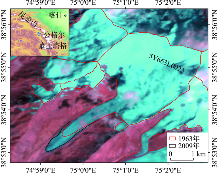
昆盖山位于东帕米高原中部,近东西走向,长约120 km,宽约40 km,其北为外阿赖山,南为公格尔和慕士塔格山,西为萨雷阔勒岭,东部为塔克拉玛干沙漠,海拔相对于公格尔和慕士塔格山较低,但山脊主线仍然在6000 m以上。昆盖山共发育现代冰川288条,面积588.5 km2。本文研究的5Y663L0023冰川(图1)系位于西南坡的一条冰川,根据中国第二次冰川编目(刘时银等, 2015),该冰川2009年的面积为10.5 km2,冰川积累区面积比率较大,达0.85,雪线高度5100 m,作用正差(雪线与山顶之间的高程差)为1100 m。东帕米尔地区气候寒冷而干燥,根据塔什库尔干气象站(海拔3090 m)的观测资料,1957-2012年年均气温3.56 ℃,年均总降水量75.2 mm。
图1 研究区示意图及5Y663L0023冰川1963年和2009年冰川编目的边界范围(图中底图为2009年9月19日Landsat TM影像)
Fig.1 The study area and glacier distribution,1963 and 2009 (Background image: Landsat 5 TM of 19 September 2009)
本文主要采用中国第一次和第二次冰川编目、Landsat、ASTER立体像对等数据(表1)。冰川编目和Landsat数据主要用于冰川长度变化的监测,ASTER立体像对数据主要用于冰川高程变化的监测。ASTER是搭载Terra卫星的一个对地观测传感器,拥有可见光与近红外(VNIR)、短波红外(SWIR)、热红外(TIR)三个不同空间分辨率的子系统。VNR(VNIR)的3N和3B波段可以构成基高比(B/H)为0.6的立体像对(Toutin, 2008)。本文使用的是经过重构的未经处理的数据Level 1A,在ENVI软件中提取DEM,平面和垂直控制点分别来自Landsat影像和地形图,分辨率设为30 m,坐标系统一为WGS84/EGM96。此外,气象数据来源于中国气象数据网(http://data.cma.cn/)。
表1 本研究所使用的ASTER及Landsat数据
Tab.1 The ASTER and Landsat images used in our study
| 影像 | 日期 | 最高空间分辨率/m | 主要用途 |
|---|---|---|---|
| ASTER | 2001年 2月22日 | 15 | 提取冰川表面高程 |
| ASTER | 2007年 8月21日 | 15 | 提取冰川表面高程 |
| ASTER | 2008年10月26日 | 15 | 提取冰川表面高程 |
| ASTER | 2013年 7月29日 | 15 | 提取冰川表面高程 |
| Landsat TM | 1991年 3月26日 | 30 | 提取冰川长度和面积 |
| Landsat TM | 1992年 7月18日 | 30 | 提取冰川长度和面积 |
| Landsat TM | 2009年 7月26日 | 30 | 提取冰川长度和面积 |
| Landsat TM | 2011年 5月 4日 | 30 | 提取冰川长度和面积 |
| Landsat ETM+ | 2007年 8月 5日 | 15 | 提取冰川长度和面积 |
| Landsat ETM+ | 2007年 9月22日 | 15 | 提取冰川长度和面积 |
| Landsat ETM+ | 2007年11月 9日 | 15 | 提取冰川长度和面积 |
| Landsat ETM+ | 2008年 5月 3日 | 15 | 提取冰川长度和面积 |
| Landsat ETM+ | 2008年10月26日 | 15 | 提取冰川长度和面积 |
| Landsat OLI | 2013年10月 9日 | 15 | 提取冰川长度和面积 |
3.2.1 冰川面积、长度提取方法
冰川跃动过程中的面积和长度的变化是基于冰川边界提取的。1963年和2009年两期冰川边界是基于修订后的中国第一次和第二次冰川编目获取的,然后基于Landsat影像,通过人工修订的方法解译得出其他期的冰川边界(孙美平等, 2015; 邢武成等, 2017; 张慧等, 2017)。冰川长度的提取首先基于面积最大的一期边界提取主流线(姚晓军等, 2015),然后利用其他期的冰川边界对其进行分割,即可得到不同时期的冰川长度。
3.2.2 DEM配准方法
不同DEM之间可能存在空间匹配误差,因此在研究冰川高程变化前有必要对该误差进行减少或消除,即以一个DEM为基准对另一个DEM进行配准。不同DEM数据间的高程偏差(dh)与坡度(α)、坡向(
式中:
经过公式(3)-(5)完成一次平移后的DEM不一定能够完全消除空间匹配误差,一般需要把一次平移后的DEM再次进入迭代过程,Nuth等(2011)推荐迭代结束的条件是dh标准差减少低于2%或者平移不足0.5 m。DEM配准时选择非冰川区稳定区域。不同DEM数据间的高程差可能会出现异常值,进而影响参数的拟合,因此,在DEM配准前须对异常值进行剔除。有研究者使用固定阈值比如高程偏差超过±100 m对异常值进行剔除(Bolch et al, 2011),也有研究者根据统计值5%和95%的分位数剔除异常值(Pieczonka et al, 2013),本文在DEM配准时,根据实际情况选择5%和95%的分位数进行异常值剔除。不同DEM之间的偏移量如表2所示。
表2 不同DEM之间的偏移量(单位m)
Tab.2 The x-y-z-shift vector between two DEMs (Unit: m)
| 基准DEM | 待配准DEM | x偏移量 | y偏移量 | z偏移量 |
|---|---|---|---|---|
| 2001DEM | 2007DEM | 20.25 | 15.51 | -0.73 |
| 2007DEM | 2008DEM | -3.36 | -6.21 | 4.01 |
| 2008DEM | 2013DEM | 16.74 | 4.48 | -27.35 |
3.2.3 不确定性分析
冰川长度的不确定性(EL)评估公式为:
式中:
式中:EL1和EL2分别为两期的冰川长度不确定性。本文采用的是USGS正射校正后的Landsat影像。研究显示其正射校正的精度(
冰川边界精度小于半个像元,因此以半个像元为直径对冰川轮廓线作缓冲区,其缓冲区面积即为冰川面积的不确定性。其变化的不确定性(EAC)可用下式评估:
式中:EA1和EA2为两期边界的不确定性。
不同DEM在配准后仍然存在一定的高程差残差,该高程差残差一般通过无冰区的标准平均误差(SE)进行评估(Bolch et al, 2011):
式中:N为采样像元的个数。为消除DEM空间自相关对误差评估的影响,N实际为去除自相关后的像元个数。本文采用Bolch等(2011)采用的保守的估计,针对30 m分辨率的DEM以600 m为去自相关距离。高程变化的不确定性(σ)可用非冰川区稳定区域的残差平均值(MED)和SE表示:
高程变化不确定性评估结果如表3所示。
表3 DEM高程差不确定性
Tab.3 The uncertainties of DEM differences
| 时期 | 校正前/m | 校正后/m | N | SE/m | σ/m | |||
|---|---|---|---|---|---|---|---|---|
| MED | STDV | MED | STDV | |||||
| 2001-2007 | 4.56 | 20.55 | -0.90 | 19.13 | 35444 | 0.10 | 0.91 | |
| 2007-2008 | 5.31 | 15.06 | -0.15 | 15.06 | 34682 | 0.08 | 0.17 | |
| 2008-2013 | 26.74 | 25.85 | -0.27 | 25.98 | 29792 | 0.15 | 0.31 | |
虽然并非所有的跃动冰川都会表现出末端前进,比如距离5Y663L0023冰川仅30 km的克拉牙依拉克冰川2015年跃动后至今未发生末端前进(Shangguan et al, 2016),但是冰川末端的快速前进现象是冰川跃动遥感识别最显著的特征。本文通过对Landsat 影像进行分析(图2、图3),5Y663 L0023冰川1990年以前末端长度没有发生明显变化,1990-1992年间发生了缓慢前进,期间末端前进了81±30 m;1993-2007年冰川末端没有明显变化。冰川大幅度前进主要发生在2007年8月5日-11月9日,期间冰川前进了538±30 m(图2、图3);其次是2008年冰川前进了166±30 m;再次是2009-2011年冰川前进了107±30 m;2011-2017年冰川末端没有发生明显变化。从冰川前进幅度可以推测,2007-2011年该冰川发生过跃动,其跃动期有4 a,2011年之后冰川进入平静期。
图2 1990-2011年5Y663L0023冰川面积和长度的变化
Fig.2 Changes of the length and area of Glacier 5Y663L0023, 1990-2011
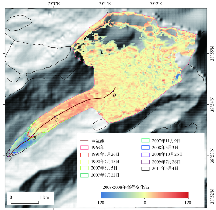
图3 1963-2011年5Y663L0023冰川末端变化及2007年8月21日-2008年10月26日冰川表面高程变化
(背景图:SRTM DEM生成的山体阴影)
Fig.3 Changes of the terminuses of Glacier 5Y663L0023, together with glacierized area, 1990-2011 and elevation difference between 21 August 2007 and 26 October 2008 (Background image: Hillshade from SRTM DEM)
1963-2011年,5Y663L0023冰川面积从10.06±0.10 km2增加到10.55±0.27 km2。冰川长度与冰川面积变化趋势基本一致(图2),冰川面积增长主要发生在2007年8月5日-11月9日,期间冰川面积增加了0.38±0.03 km2,占1963-2011年面积总扩张面积的78%;2011-2017年冰川面积没有变化。
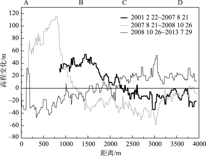
为了定量分析跃动冰川表面高程变化过程,本文选择质量较好的2001年2月22日、2007年8月21日、2008年10月26日、2013年7月29日四期ASTER立体像对数据对跃动前后的冰川高程变化进行分析。与冰川面积变化和长度变化情况类似,高程变化主要发生在2007-2008年(图3、图4)。根据2001-2007年冰川高程变化监测结果(图4)可以看出,2007年8月21日前该冰川已经开始跃动。结合长度和面积变化的监测(图2和图3)得知,冰川跃动开始启动时间可能在2007年8月21日前,CD处冰体开始卸载,至2007年8月21日卸载冰体体积达6.6×10⁶ m3。2007年8月21日-2008年10月26日,CD处冰体继续卸载并带动BC处冰体卸载,卸载体积(BD处)合计32.7×10⁶ m3(其中CD处卸载体积21.9×10⁶ m3),大量冰体卸载引发冰川大幅度前进(704±30 m),面积增加0.34±0.03 km2,末端抬高最高可达128.17±0.17 m。
图4 不同时期冰川消融区(即
Fig.4 Elevation change profiles along a transect from A to D (
2008年10月26日-2013年7月29日,冰川末端AB处平均减薄18.28±0.31 m。由冰川面积和长度变化结果可知,跃动期持续到2011年。尽管2008-2011年末端可能出现增厚的现象,但由于末端所处的海拔较低对气候变化的响应相对显著,因此,2008-2013年冰川末端可能先增厚后减薄,整体呈现减薄态势(图4)。由于积累区DEM效果不佳,本文无法得到完整冰川的表面高程变化。不过,BD段高程增加9.64±0.31 m。研究区附近的慕士塔格峰冰川1995-2003年以来的年均冰芯积累量仅有605 mm,最大为1390 mm(段克勤等, 2003)。再考虑到近些年降水增加(Yao et al, 2012),故2008-2013年BD处高程呈现大幅度增加。不过,填补积蓄区的积雪短时间内并未转换为冰层和冰川运动引起的物质重分配,2008-2013年BD段的高程变化并不能完全反映期间冰川厚度的变化。
一个完整的冰川跃动周期包括跃动期和平静期。目前没有针对东帕米尔地区冰川跃动周期的研究。研究表明,西帕米尔地区跃动冰川跃动期从数月到10 a不等(Kotlyakov et al, 2008),大多数冰川跃动期都在2 a以上(Dowdeswell et al, 1991)。根据2007-2013年冰川面积、长度和表面高程变化,5Y663L0023冰川跃动期在4 a (2007-2011年)左右;与此类似,西帕米尔Bivachny冰川跃动期也为4 a (Kotlyakov et al, 2008);而公格尔峰的克拉牙依拉克冰川跃动期只有数月;喀喇昆仑山的冰川跃动期也相对较短,从数月到几年不等(Hewitt, 2007; Copland et al, 2011)。跃动期前后是相对时间较长的平静期,平静期的长短一般取决于降雪,即积雪填平积蓄区所需要的时间(Eisen et al, 2001)。挪威斯瓦尔巴特群岛地区冰川跃动期达4~10 a,其平静期可达50~500 a (Dowdeswell et al, 1991)。阿拉斯加地区降雪率高于斯瓦尔巴特群岛地区,其冰川平静期相对较短(Eisen et al, 2001)。东帕米尔地区属极大陆型气候,降水稀少(年降水量仅仅75~100 mm),甚至小于斯瓦尔巴特群岛,由此推断该地区冰川跃动周期可能很长。不过西帕米尔的跃动周期却很短,比如熊(Medvezhiy)冰川每隔10~14 a跃动一次,Bivachny冰川每隔15~20 a跃动一次。一方面西帕米尔地区降水较多,另一方面气候也不是控制冰川跃动周期的唯一因素(Björnsson et al, 2003)。由于资料匮乏,本文没有确凿证据证明1990-1992年冰川前进与跃动是否相关,但如果该时期冰川前进是跃动造成的,那么该冰川跃动周期与熊冰川、Bivachny冰川类似,其平静期可能在15 a左右。因此,今后需要重点关注2026年前后的冰川变动状况。塔什库尔干气象站的观测资料(图5)表明,东帕米尔地区自20世纪90年代以来降水呈现增加的趋势。冰川区域气候较为复杂,其降水可能增加更多,积蓄区填满所需的时间缩短,即平静期也有可能缩短。
图5 1957-2012年塔什库尔干气象站观测资料的年平均气温和降水距平的变化
Fig.5 Annual mean air temperature anomaly and precipitation anomaly at Taxkorgan Meteorological Station, 1957-2012
冰川跃动的基本原因是冰川动力不稳定性,在冰川跃动部分的上游,物质积累大于消融,而下游则为物质收入大于支出,其差别逐渐扩大,直到应力松弛性卸荷,表现为冰川的整体性受到破坏及冰川流速的急剧增加。根据前人的研究成果(Quincey et al, 2015),可将跃动冰川的类型分为两类:一是温性冰川(热力机制控制),夏季大量融水进入冰内和冰下,水量增加导致静水压力的增加,冰川底部有效应力(冰覆盖层压力与静水压力之差)达到某一临界值时,储水洞穴打开,排水系统扩张导致有效应力发生变化,静水压力下降引发排水系统坍塌,水流润滑增加底部运动速度,进而触发冰川跃动(Kamb et al, 1985; Björnsson et al, 1998; Burgess et al, 2012; Lingle et al, 2013);二是多温型冰川(水文机制控制),物质不断积累导致底部温度达到压力熔点,冰川底部静水压力增加导致底部快速滑动(Clarke et al, 1984; Murray et al, 2000)。
根据我国第一次冰川编目资料,本区域冰川跃动前冰川作用正差为1100 m,积累区面积比率为0.85,冰川作用系数为5.91,表明该冰川极其不稳定。本区域跃动冰川积累区面积相对较大,且地势较为陡峭,其向下迁移的雪冰不断堆积到积蓄区,即图3的CD处,导致该区域冰的蠕变速率增加,产生热量,当冰体底部温度达到压力融点时引发跃动。跃动后积蓄区的冰体向下转移,随之进入恢复期。在恢复期中,积蓄区再次接收上游物质的转移,继而进入下一次跃动周期,因此该冰川属于多温型冰川的可能性较大。
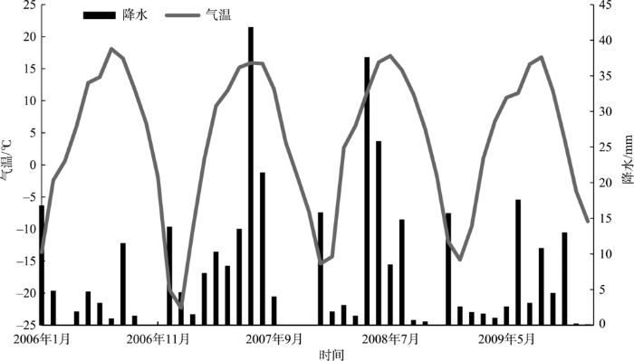
从2007-2008年前后的塔什库尔干气象资料(图6)可知,2007年7月降水较大。固体降水的增加尽管会影响积蓄区压融滑动,但如果降水中液态降水的比例较大,可能有部分降水通过冰川裂缝进入冰下或冰内。通过图2和图3可以看出,该冰川跃动的积蓄区在冰舌消融区(图2中的CD处),7-8月也是冰川的消融期,冰川融水也可能通过裂缝进入冰下或冰内。尽管2007年前后的年气温有降低的趋势(图5),但是7-8月的气温仍然处于较高水平(图6)。此外,冰下或冰内也可能存储以前的冰雪融水或者其他滞流水等等。比如王宁练等(2013)在昆仑山玉珠峰冰川内部发现富含水冰层,其富含水冰层的形成与气候变暖相关。因此,20世纪90年代以来的气温上升(图5)可能是2007年跃动的诱因,冰下或者冰内液态水的增多引发冰川跃动。Kääb等人(2018)对2016年西藏阿汝错冰崩事件的分析也表明,冰川融水和降水的增加导致冰川系统内液态水含量的增加,减小了冰川底部的摩擦力,最终引发冰崩灾害。因此,尽管本文的冰川属于多温型冰川,跃动受热力学机制影响的可能性较大,但液态降水、冰雪融水等也可能改变了冰内的水文条件,其水文控制因素也不可忽略。Quincey等(2015)认为,喀喇昆仑山跃动冰川受热力学机制和水文机制共同控制,因此东帕米尔高原跃动冰川机制可能与喀喇昆仑山相一致。
图6 2006-2009年塔什库尔干气象站观测资料月平均气温和降水的变化
Fig.6 Monthly average air temperature and precipitation at Taxkorgan Meteorological Station, 2006-2009
本文利用Landsat影像对东帕米尔高原过去近50年前进幅度最大的5Y663L0023冰川的跃动过程进行了分析,并利用ASTER立体像对和SRTM对2000-2013年冰川高程变化进行了分析,主要结论为:
(1) 该冰川于1990-1992和2007-2011年分别前进了81±30 m、811±30 m,1993-2007年和2013-2017年冰川末端无明显变化。1990-2011年面积增加了0.49 km2。其中2007-2011年冰川前进是跃动造成的,2007年8月5日前后开始发生跃动,跃动期持续到2011年;其中2007年8月21日至2008年10月26日达到最高峰,共32.7×10⁶ m3的冰体发生卸载,导致末端前进了704±30 m,面积扩张了0.34 km2。
(2) 该冰川跃动周期中跃动期为4 a,但平静期无法确定,最短可能为15 a左右,目前尚无法判断1990-1992年间的冰川前进是否为跃动引起的,不过可以重点关注2026年左右该冰川变化动态。此外,在降水增加的背景下,平静期也可能缩短。
(3) 该冰川属于多温型冰川,跃动受热力学机制影响的可能性较大,但液态降水、冰雪融水的增加也可能改变其水文条件,因此,其水文控制因素也不可忽略。该冰川跃动机制可能与喀喇昆仑山跃动冰川相一致。
The authors have declared that no competing interests exist.
| [1] |
慕士塔格冰芯降水记录及其对冰川水资源的气候意义 [J].https://doi.org/10.3969/j.issn.1000-0240.2007.05.002 URL Magsci [本文引用: 1] 摘要
2003年在东帕米尔慕士塔格冰川海拔7010 m处钻取了的一支长41.6 m的冰芯,从中恢复了1955年以来的积累量.结果表明:自20世纪70年代以来,冰川积累量持续减少,特别近年来积累量呈加速减小趋势;平均而言,20世纪90年代后期至2003年平均积累量只有20世纪60年代冰川积累量的一半.重建的慕士塔格地区冰川物质平衡近20 a来亏损严重,主要是由近年来慕士塔格高山区降水的减小和温度的升高共同作用引起的.对主要以冰川融水为补给的塔里木河流域上游山区而言,短期冰川融水的增加会调节河流径流,而当冰川得不到足够的降水补充时,冰川的退化必然影响到下游的河流径流.
Records of precipitation in the Muztag Ata Ice Core and its climate significance to glacier water resources [J].https://doi.org/10.3969/j.issn.1000-0240.2007.05.002 URL Magsci [本文引用: 1] 摘要
2003年在东帕米尔慕士塔格冰川海拔7010 m处钻取了的一支长41.6 m的冰芯,从中恢复了1955年以来的积累量.结果表明:自20世纪70年代以来,冰川积累量持续减少,特别近年来积累量呈加速减小趋势;平均而言,20世纪90年代后期至2003年平均积累量只有20世纪60年代冰川积累量的一半.重建的慕士塔格地区冰川物质平衡近20 a来亏损严重,主要是由近年来慕士塔格高山区降水的减小和温度的升高共同作用引起的.对主要以冰川融水为补给的塔里木河流域上游山区而言,短期冰川融水的增加会调节河流径流,而当冰川得不到足够的降水补充时,冰川的退化必然影响到下游的河流径流.
|
| [2] |
木孜塔格西北坡鱼鳞川冰川跃动遥感监测 [J].
基于Landsat卫星数据的遥感监测发现, 木孜塔格峰西北坡鱼鳞川冰川的中支在2007-2011年间发生了跃动, 冰川北侧末端在几年内前进距离达到了(548±34) m.进一步的监测发现, 该冰川的大幅跃动主要发生于2008年10月至2009年3月.跃动期间冰川表面约4.8 km长的范围经历了急剧的破碎化过程, 并呈现出最早由冰川中部积蓄区下段开始, 然后向上下游逐渐扩展的特征.对冰面裂隙及其他特征点的追踪发现, 冰川除积累区以外的部位都产生明显的位移, 其中冰川中部以下至冰舌部各点的位移都在1 km以上.同时, 冰面运动速度的计算结果也显示, 冰川各个部分都经历了急剧的运动速度变化过程, 其中冰川中部最大运动可视速率达到约(13.3±1.5)m·d<sup>-1</sup>, 并且还揭示出该冰川的跃动具有北侧主末端最先开始快速运动, 然后向上游逐渐扩展的特征.
Monitoring recent surging of the Yulinchuan Glacier on north slopes of Muztag Rang by remote sensing [J].
基于Landsat卫星数据的遥感监测发现, 木孜塔格峰西北坡鱼鳞川冰川的中支在2007-2011年间发生了跃动, 冰川北侧末端在几年内前进距离达到了(548±34) m.进一步的监测发现, 该冰川的大幅跃动主要发生于2008年10月至2009年3月.跃动期间冰川表面约4.8 km长的范围经历了急剧的破碎化过程, 并呈现出最早由冰川中部积蓄区下段开始, 然后向上下游逐渐扩展的特征.对冰面裂隙及其他特征点的追踪发现, 冰川除积累区以外的部位都产生明显的位移, 其中冰川中部以下至冰舌部各点的位移都在1 km以上.同时, 冰面运动速度的计算结果也显示, 冰川各个部分都经历了急剧的运动速度变化过程, 其中冰川中部最大运动可视速率达到约(13.3±1.5)m·d<sup>-1</sup>, 并且还揭示出该冰川的跃动具有北侧主末端最先开始快速运动, 然后向上游逐渐扩展的特征.
|
| [3] |
1990-2011年西昆仑峰区冰川变化的遥感监测 [J].https://doi.org/10.11820/dlkxjz.2013.04.007 Magsci [本文引用: 1] 摘要
本文应用Landsat 5、7 TM、ETM+影像分析1990-2011年昆仑山西段昆仑峰区冰川变化特征,结果表明:1990-2011年冰川面积减少16.83 km<sup>2</sup>,退缩率仅为0.65%,冰川退缩趋势不明显。单条冰川变化有进有退,中峰冰川末端在2002-2004年以661 m/a的速率前进,初步判定为跃动冰川。1991-1998年,崇测冰川面积增加9.47 km<sup>2</sup>,冰川末端以200 m/a的速率前进,不排除有跃动冰川的可能性。尽管近年来全球气温普遍上升,大量冰川处于退缩状态,但统计已有研究结果发现近50年来青藏高原存在冰川长度、面积增加,冰川物质平衡为正的现象,表现出冰川对气候变化复杂的反馈机制。通过分析气象站点和冰芯资料,研究区周边地区气温上升、降水量缓慢增加可能是冰川微弱退缩的原因之一;增强的西风环流带来更多的降水、研究区以极大陆型大规模冰川为主,也可能是冰川退缩幅度较小的原因。
Variation of West Kunlun Mountains glacier during 1990-2011 [J].https://doi.org/10.11820/dlkxjz.2013.04.007 Magsci [本文引用: 1] 摘要
本文应用Landsat 5、7 TM、ETM+影像分析1990-2011年昆仑山西段昆仑峰区冰川变化特征,结果表明:1990-2011年冰川面积减少16.83 km<sup>2</sup>,退缩率仅为0.65%,冰川退缩趋势不明显。单条冰川变化有进有退,中峰冰川末端在2002-2004年以661 m/a的速率前进,初步判定为跃动冰川。1991-1998年,崇测冰川面积增加9.47 km<sup>2</sup>,冰川末端以200 m/a的速率前进,不排除有跃动冰川的可能性。尽管近年来全球气温普遍上升,大量冰川处于退缩状态,但统计已有研究结果发现近50年来青藏高原存在冰川长度、面积增加,冰川物质平衡为正的现象,表现出冰川对气候变化复杂的反馈机制。通过分析气象站点和冰芯资料,研究区周边地区气温上升、降水量缓慢增加可能是冰川微弱退缩的原因之一;增强的西风环流带来更多的降水、研究区以极大陆型大规模冰川为主,也可能是冰川退缩幅度较小的原因。
|
| [4] |
2009年夏季喀喇昆仑山叶尔羌河上游发生冰川跃动 [J].https://doi.org/10.1016/S1003-6326(09)60084-4 URL Magsci [本文引用: 1] 摘要
喀喇昆仑山叶尔羌河冰川突发洪水在沉寂10a后,近10a(1997—2006年)又频繁发生.叶尔羌河上游支流克勒青河谷左岸喀喇昆仑山常年为冰雪覆盖,有多处庞大山谷冰川,其走向均为从喀喇昆仑山脉北坡向下流入河谷,5条进入河谷的大山谷冰川长度和面积都分别超过20km和100km2.2009年5月
A glacier surge found in the upstream area of Yarkant River, Karokorum Mountain, summer 2009 [J].https://doi.org/10.1016/S1003-6326(09)60084-4 URL Magsci [本文引用: 1] 摘要
喀喇昆仑山叶尔羌河冰川突发洪水在沉寂10a后,近10a(1997—2006年)又频繁发生.叶尔羌河上游支流克勒青河谷左岸喀喇昆仑山常年为冰雪覆盖,有多处庞大山谷冰川,其走向均为从喀喇昆仑山脉北坡向下流入河谷,5条进入河谷的大山谷冰川长度和面积都分别超过20km和100km2.2009年5月
|
| [5] |
基于第二次冰川编目的中国冰川现状 [J].The contemporary glaciers in China based on the Second Chinese Glacier Inventory [J]. |
| [6] |
喀喇昆仑山克勒青河谷近年来发现有跃动冰川 [J].
根据冰川编目、Landsat MSS/TM/ETM+影像和相关的历史考察制图,利用GIS进行了不同时期的冰川分布图的制作,对比分析了不同时期冰川范围.重点监测了喀喇昆仑山北坡克勒青河的5Y654D48、5Y654D97的不同时段内的冰川运动状况.结果发现:5Y654D48冰川和5Y654D97冰川分别在1990—2000年与1977—1990年间运动速度达272 m·a<sup>-1</sup>,213.1 m·a<sup>-1</sup>,比其它时段运动速度大7~20倍,具备跃动冰川的运动特征.分析认为,5Y654D48冰川在1990—2000年、5Y654D97在1977—1990年间曾分别发生过冰川跃动.
Surging glacier found in Shaksgam River, Karakorum Mountains [J].
根据冰川编目、Landsat MSS/TM/ETM+影像和相关的历史考察制图,利用GIS进行了不同时期的冰川分布图的制作,对比分析了不同时期冰川范围.重点监测了喀喇昆仑山北坡克勒青河的5Y654D48、5Y654D97的不同时段内的冰川运动状况.结果发现:5Y654D48冰川和5Y654D97冰川分别在1990—2000年与1977—1990年间运动速度达272 m·a<sup>-1</sup>,213.1 m·a<sup>-1</sup>,比其它时段运动速度大7~20倍,具备跃动冰川的运动特征.分析认为,5Y654D48冰川在1990—2000年、5Y654D97在1977—1990年间曾分别发生过冰川跃动.
|
| [7] |
近 50年来祁连山冰川变化: 基于中国第一、二次冰川编目数据 [J].Glacier changes in the Qilian Mountains in the past half century: Based on the revised First and Second Chinese Glacier Inventory [J]. |
| [8] |
青藏高原冰川内部富含水冰层的发现及其环境意义 [J].https://doi.org/10.7522/j.issn.1000-0240.2013.0152 URL Magsci [本文引用: 1] 摘要
<p>基于青藏高原昆仑山玉珠峰冰川Core 1冰芯钻取过程中所获得的相关资料,揭示出在该冰芯钻取点处的冰川内部34.34~34.64 m深度段存在一个富含水冰层,其未冻水(液态水)具有承压性质,水头高度至少可达到8.54 m. 该富含水冰层的存在不仅对冰川温度场带来了极大的影响,而且使该层中δ<sup>18</sup>O记录趋于均一化. 通过分析,揭示出该富含水冰层中可溶杂质离子浓度明显高于其上部冰层中的可溶杂质离子浓度,这是富含水冰层在形成初期其上部粒雪层融水下渗所引起的可溶杂质离子淋溶的结果. 同时,研究表明玉珠峰冰川粒雪中可溶杂质离子的优先淋溶顺序为NO<sub>3</sub><sup>-</sup>> Mg<sup>2+</sup>> Na<sup>+</sup>> Cl<sup>-</sup>> K<sup>+</sup>> SO<sub>4</sub><sup>2-</sup>> Ca<sup>2+</sup>> NH<sub>4</sub><sup>+</sup>. 提出可利用最易淋溶离子的浓度与最不易淋溶离子的浓度之比值,来判断冰雪层中可溶杂质离子浓度峰值是否与淋溶有关. 结合青藏高原其他地点冰芯钻取过程中发现的富含水冰层状况,认为青藏高原冰川内部富含水冰层不是在整个冰川区域内呈层状分布,而是在冰川内部呈透镜状分布. 冰川内部富含水冰层的存在,表明其形成初期气候相对较暖. 最后,阐明了青藏高原冰川中富含水冰层的形成机理与演化过程,并预测了其潜在的灾害效应.</p>
Discovery of the water-rich ice layers in glaciers on the Tibetan Plateau and its environmental significances [J].https://doi.org/10.7522/j.issn.1000-0240.2013.0152 URL Magsci [本文引用: 1] 摘要
<p>基于青藏高原昆仑山玉珠峰冰川Core 1冰芯钻取过程中所获得的相关资料,揭示出在该冰芯钻取点处的冰川内部34.34~34.64 m深度段存在一个富含水冰层,其未冻水(液态水)具有承压性质,水头高度至少可达到8.54 m. 该富含水冰层的存在不仅对冰川温度场带来了极大的影响,而且使该层中δ<sup>18</sup>O记录趋于均一化. 通过分析,揭示出该富含水冰层中可溶杂质离子浓度明显高于其上部冰层中的可溶杂质离子浓度,这是富含水冰层在形成初期其上部粒雪层融水下渗所引起的可溶杂质离子淋溶的结果. 同时,研究表明玉珠峰冰川粒雪中可溶杂质离子的优先淋溶顺序为NO<sub>3</sub><sup>-</sup>> Mg<sup>2+</sup>> Na<sup>+</sup>> Cl<sup>-</sup>> K<sup>+</sup>> SO<sub>4</sub><sup>2-</sup>> Ca<sup>2+</sup>> NH<sub>4</sub><sup>+</sup>. 提出可利用最易淋溶离子的浓度与最不易淋溶离子的浓度之比值,来判断冰雪层中可溶杂质离子浓度峰值是否与淋溶有关. 结合青藏高原其他地点冰芯钻取过程中发现的富含水冰层状况,认为青藏高原冰川内部富含水冰层不是在整个冰川区域内呈层状分布,而是在冰川内部呈透镜状分布. 冰川内部富含水冰层的存在,表明其形成初期气候相对较暖. 最后,阐明了青藏高原冰川中富含水冰层的形成机理与演化过程,并预测了其潜在的灾害效应.</p>
|
| [9] |
1959年来中国天山冰川资源时空变化 [J].https://doi.org/10.11821/dlxb201709005 URL [本文引用: 1] 摘要
基于两期冰川编目数据与气象数据,对天山1959年来冰川资源的时空变化特征进行研究。研究发现:(1)天山地区现有冰川7934条,面积7179.77 km~2,冰储量756.48 km~3。冰川数量以面积1 km~2的冰川居多,面积以1~10 km~2和≥20 km~2的冰川为主,冰川集中分布在海拔3800~4800 m之间。(2)在四级流域中,阿克苏河流域冰川面积最大为1721.75 km~2,面积最小的是伊吾河流域,为56.03 km~2。在各市(州)中,阿克苏地区冰川资源量最多,其面积和储量分别占天山总量的43.28%和68.85%;冰川资源量最少的市(州)是吐鲁番地区,面积和储量仅占天山总量的0.23%和0.07%。(3)1959年来,天山地区冰川面积减少了1619.82 km~2(-18.41%),储量亏损了104.78 km~3(-12.16%),其中数量以1 km~2的冰川减少最多,面积减少以5 km~2的冰川最为严重。(4)冰川变化呈现明显的区域差异,变化速度最快的是天山东段博格达北坡流域,变化最慢的是中部的渭干河流域。初步分析认为夏季气温显著上升带来的消融大于年内降水带来的积累是天山冰川退缩的主要原因。
Spatial-temporal variation of glacier resources in Chinese Tianshan Mountains since 1959 [J].https://doi.org/10.11821/dlxb201709005 URL [本文引用: 1] 摘要
基于两期冰川编目数据与气象数据,对天山1959年来冰川资源的时空变化特征进行研究。研究发现:(1)天山地区现有冰川7934条,面积7179.77 km~2,冰储量756.48 km~3。冰川数量以面积1 km~2的冰川居多,面积以1~10 km~2和≥20 km~2的冰川为主,冰川集中分布在海拔3800~4800 m之间。(2)在四级流域中,阿克苏河流域冰川面积最大为1721.75 km~2,面积最小的是伊吾河流域,为56.03 km~2。在各市(州)中,阿克苏地区冰川资源量最多,其面积和储量分别占天山总量的43.28%和68.85%;冰川资源量最少的市(州)是吐鲁番地区,面积和储量仅占天山总量的0.23%和0.07%。(3)1959年来,天山地区冰川面积减少了1619.82 km~2(-18.41%),储量亏损了104.78 km~3(-12.16%),其中数量以1 km~2的冰川减少最多,面积减少以5 km~2的冰川最为严重。(4)冰川变化呈现明显的区域差异,变化速度最快的是天山东段博格达北坡流域,变化最慢的是中部的渭干河流域。初步分析认为夏季气温显著上升带来的消融大于年内降水带来的积累是天山冰川退缩的主要原因。
|
| [10] |
1978-2015年喀喇昆仑山克勒青河流域冰川变化的遥感监测 [J].Variation of glaciers in the Shaksgam River Basin, Karakoram Mountains during 1978-2015 [J]. |
| [11] |
长江黄河源区冰川变化及其对河川径流的影响 [J].https://doi.org/10.11849/zrzyxb.2003.05.012 Magsci [本文引用: 1] 摘要
以位于青藏高原长江源头的各拉丹冬地区和黄河源区的阿尼玛卿山地区冰川为例,利用两期遥感影像资料(长江源为1969年和2000年,黄河源为1966年和2000年),在地理信息系统技术的支持下分析研究区典型冰川作用区小冰期(LIA)、1969年(1966年)和2000年的冰川范围变化、冰川进退情况,在此基础上,运用由点到面的研究方法,外推整个长江和黄河源区近几十年来的冰川变化情况,并以沱沱河流域为例,分析了冰川变化对河川径流的影响。结果表明,长江源各拉丹冬地区1969~2000年冰川总面积减少了1.7%,而黄河源阿尼玛卿山地区冰川面积减少是长江源区的10倍,同期,长江源区冰川末端的最大退缩速率为每年41.5m,而黄河源区每年为57.4m,与黄河源区相比,长江源区冰川退缩速度不是太大,基本上处于稳定状态,且有前进冰川存在。20世纪60年代以来,江河源区冰川虽呈长期退缩的总趋势,但也出现过明显的前进,长江源区在1969年~1995年,黄河源区在1966年至1981年,大多数冰川处于前进状态或稳定。长江源区冰川转入退缩阶段的时间要比黄河源区晚约10a左右。冰川退缩使长江源区和黄河源区年均各自损失冰川水资源约0.7×108m<sup>3</sup>。由于长江源区冰川变化幅度小,虽冰川退缩使冰川融水径流量有所增加,但对径流的影响程度相对较小。
Glacier change and its effect on surface runoff in the source regions of the Yangtze and Yellow rivers [J].https://doi.org/10.11849/zrzyxb.2003.05.012 Magsci [本文引用: 1] 摘要
以位于青藏高原长江源头的各拉丹冬地区和黄河源区的阿尼玛卿山地区冰川为例,利用两期遥感影像资料(长江源为1969年和2000年,黄河源为1966年和2000年),在地理信息系统技术的支持下分析研究区典型冰川作用区小冰期(LIA)、1969年(1966年)和2000年的冰川范围变化、冰川进退情况,在此基础上,运用由点到面的研究方法,外推整个长江和黄河源区近几十年来的冰川变化情况,并以沱沱河流域为例,分析了冰川变化对河川径流的影响。结果表明,长江源各拉丹冬地区1969~2000年冰川总面积减少了1.7%,而黄河源阿尼玛卿山地区冰川面积减少是长江源区的10倍,同期,长江源区冰川末端的最大退缩速率为每年41.5m,而黄河源区每年为57.4m,与黄河源区相比,长江源区冰川退缩速度不是太大,基本上处于稳定状态,且有前进冰川存在。20世纪60年代以来,江河源区冰川虽呈长期退缩的总趋势,但也出现过明显的前进,长江源区在1969年~1995年,黄河源区在1966年至1981年,大多数冰川处于前进状态或稳定。长江源区冰川转入退缩阶段的时间要比黄河源区晚约10a左右。冰川退缩使长江源区和黄河源区年均各自损失冰川水资源约0.7×108m<sup>3</sup>。由于长江源区冰川变化幅度小,虽冰川退缩使冰川融水径流量有所增加,但对径流的影响程度相对较小。
|
| [12] |
基于GIS的冰川中流线自动提取方法设计与实现 [J].https://doi.org/10.7522/j.issn.1000-0240.2015.0173 Magsci [本文引用: 1] 摘要
冰川长度是冰川编目的重要组成部分, 在冰川变化研究中具有十分重要的作用. 基于冰川轮廓矢量数据和数字高程模型数据, 从冰川形态角度提出了针对单一盆地与单一出口、复式盆地与单一出口、冰帽三种类型冰川的中流线自动提取方案, 并在GIS软件支持下实现了冰川海拔最高点与最低点、冰川中流线的自动提取. 以乌鲁木齐河源1号冰川、喀纳斯冰川、古里雅冰帽和野牛沟冰帽为例, 分别提取了各条冰川的中流线, 结果表明SRTM和ASTER GDEM两类数字高程模型数据对冰川海拔最高点与最低点的位置判别影响较小; 对单一盆地与单一出口类型冰川中流线实现了自动化提取, 而对于复式盆地与单一出口冰川类型和冰帽类型, 在冰川中流线提取中仍需专家知识支撑. 与我国第一次冰川编目中的长度数据相比, 本方法提取的冰川长度数据更加合理, 对于补充与完善我国第二次冰川编目数据集具有一定的参考价值.
Design and implementation of an automatic method for deriving glacier centerlines based on GIS [J].https://doi.org/10.7522/j.issn.1000-0240.2015.0173 Magsci [本文引用: 1] 摘要
冰川长度是冰川编目的重要组成部分, 在冰川变化研究中具有十分重要的作用. 基于冰川轮廓矢量数据和数字高程模型数据, 从冰川形态角度提出了针对单一盆地与单一出口、复式盆地与单一出口、冰帽三种类型冰川的中流线自动提取方案, 并在GIS软件支持下实现了冰川海拔最高点与最低点、冰川中流线的自动提取. 以乌鲁木齐河源1号冰川、喀纳斯冰川、古里雅冰帽和野牛沟冰帽为例, 分别提取了各条冰川的中流线, 结果表明SRTM和ASTER GDEM两类数字高程模型数据对冰川海拔最高点与最低点的位置判别影响较小; 对单一盆地与单一出口类型冰川中流线实现了自动化提取, 而对于复式盆地与单一出口冰川类型和冰帽类型, 在冰川中流线提取中仍需专家知识支撑. 与我国第一次冰川编目中的长度数据相比, 本方法提取的冰川长度数据更加合理, 对于补充与完善我国第二次冰川编目数据集具有一定的参考价值.
|
| [13] |
近50年新疆天山奎屯河流域冰川变化及其对水资源的影响 [J].Impact of the glacier change on water resources in the Kuytun River basin, Tianshan Mountains during recent 50 Years [J]. |
| [14] |
南迦巴瓦峰的跃动冰川 [J].
根据运动速度和运动规律的不同,冰川学家将世界上的现代冰川分为两大类:常态冰川和跃动冰川。所谓跃动冰川,是指在几小时、几天或者几个星期内突然快速前进几米、几十米甚至几公里的冰川。这类冰川跃动的周期具有一定的规律性,所以有人也把它叫做“波动冰川”。冰川跃动时,可以在很短的时间内,将沿途的森林、道路和村庄冲毁,给人类生命、财产和经济建设带来意想不到的损失。因此,有人将冰川跃动又叫做“灾难性的冰川前进”。
A surging glacier in the Nanjiabawa Peak Area, Himalayas [J].
根据运动速度和运动规律的不同,冰川学家将世界上的现代冰川分为两大类:常态冰川和跃动冰川。所谓跃动冰川,是指在几小时、几天或者几个星期内突然快速前进几米、几十米甚至几公里的冰川。这类冰川跃动的周期具有一定的规律性,所以有人也把它叫做“波动冰川”。冰川跃动时,可以在很短的时间内,将沿途的森林、道路和村庄冲毁,给人类生命、财产和经济建设带来意想不到的损失。因此,有人将冰川跃动又叫做“灾难性的冰川前进”。
|
| [15] |
新疆帕米尔跃动冰川遥感监测研究 [J].https://doi.org/10.7522/j.isnn.1000-0240.2016.0002 URL Magsci [本文引用: 3] 摘要
2015年5月,新疆克孜勒苏柯尔克孜自治州阿克陶县公格尔九别峰北坡克拉牙依拉克冰川发生跃动,造成草场和部分房屋被冰体淹没,本文针对这一冰川跃动事件的发生过程进行研究.利用2013-2015年间ASTER立体像对数据监测了克拉牙依拉克冰川的冰川表面高程的变化,并利用2015年4月13日至2015年7月11日期间的LandsatOLI数据监测了冰川的表面运动速度变化.监测发现,克拉牙依拉克冰川从2015年4月13号开始活动强烈,表面运动速度呈加快趋势,2015年5月8-15日期间冰川表面运动速度达到最高水平,其最大运动速度在西支中部达到了(20.40±0.42)m·d<sup>-1</sup>,冰川跃动达到顶峰.冰川跃动"积蓄区"位于西支冰川平衡线以下区域,跃动向下游接收区输送冰体体积约为2.4×10<sup>8</sup>m<sup>3</sup>,大量冰体堆积在东西支汇合口地段(海拔3100~3500m),造成了该处冰面隆起,其中最大隆起高度为(130.58±0.70)m.本文获得了西支冰川由静止期、跃动状态、恢复到稳定状态期间的冰面高程和表面运动速度变化,为本地区冰川跃动机理的研究奠定了基础.
Monitoring recent surging of the Karayaylak Glacier in Pamir by remote sensing [J].https://doi.org/10.7522/j.isnn.1000-0240.2016.0002 URL Magsci [本文引用: 3] 摘要
2015年5月,新疆克孜勒苏柯尔克孜自治州阿克陶县公格尔九别峰北坡克拉牙依拉克冰川发生跃动,造成草场和部分房屋被冰体淹没,本文针对这一冰川跃动事件的发生过程进行研究.利用2013-2015年间ASTER立体像对数据监测了克拉牙依拉克冰川的冰川表面高程的变化,并利用2015年4月13日至2015年7月11日期间的LandsatOLI数据监测了冰川的表面运动速度变化.监测发现,克拉牙依拉克冰川从2015年4月13号开始活动强烈,表面运动速度呈加快趋势,2015年5月8-15日期间冰川表面运动速度达到最高水平,其最大运动速度在西支中部达到了(20.40±0.42)m·d<sup>-1</sup>,冰川跃动达到顶峰.冰川跃动"积蓄区"位于西支冰川平衡线以下区域,跃动向下游接收区输送冰体体积约为2.4×10<sup>8</sup>m<sup>3</sup>,大量冰体堆积在东西支汇合口地段(海拔3100~3500m),造成了该处冰面隆起,其中最大隆起高度为(130.58±0.70)m.本文获得了西支冰川由静止期、跃动状态、恢复到稳定状态期间的冰面高程和表面运动速度变化,为本地区冰川跃动机理的研究奠定了基础.
|
| [16] |
Hydrological characteristics of the drainage system beneath a surging glacier [J].https://doi.org/10.1038/27384 URL [本文引用: 1] 摘要
A rare combination of natural circumstances permits assessment of current theories on water flow beneath glaciers. Outburst floods from the subglacial lake Grímsv02tn in Iceland took place before, during and after surging of Skei68arárj02kull, the glacier beneath which the outburst floods drain. The observable drainage patterns associated with these floods show the different nature of the basal water conduit system of the glacier during surge and non-surge phases. During surge conditions, basal water is dispersed slowly across the bed in a distributed drainage system; but when the glacier is not surging, water is transported rapidly through a system of tunnels.
|
| [17] |
Surges of glaciers in Iceland [J].https://doi.org/10.3189/172756403781816365 URL [本文引用: 1] 摘要
Surges are common in all the major ice caps in Iceland, and historical reports of surge occurrence go back several centuries. Data collection and regular observation over the last several decades have permitted a detailed description of several surges, from which it is possible to generalize on the nature of surging in Icelandic glaciers. Combining the historical records of glacier-front variations and recent field research, we summarize the geographic distribution of surging glaciers, their subglacial topography and geology, the frequency and duration of surges, changes in glacier surface geometry during the surge cycle, and measured velocity changes compared to calculated balance velocities. We note the indicators of surge onset and describe changes in ice, water and sediment fluxes during a surge. Surges accomplish a significant fraction of the total mass transport through the main outlet glaciers of ice caps in Iceland and have important implications for their hydrology. Our analysis of the data suggests that surge-type glaciers in Iceland are characterized by gently sloping surfaces and that they move too slowly to remain in balance given their accumulation rate. Surge frequency is neither regular nor clearly related to glacier size or mass balance. Steeply sloping glaciers, whether hard- or soft-bedded, seem to move sufficiently rapidly to keep in balance with the annual accumulation.
|
| [18] |
Multi-decadal mass loss of glaciers in the Everest area (Nepal Himalaya) derived from stereo imagery [J].https://doi.org/10.5194/tc-5-349-2011 URL [本文引用: 3] |
| [19] |
Surge dynamics on Bering Glacier, Alaska, in 2008-2011 [J].https://doi.org/10.5194/tc-6-1251-2012 URL [本文引用: 1] 摘要
A surge cycle of the Bering Glacier system, Alaska, is examined using observations of surface velocity obtained using synthetic aperture radar (SAR) offset tracking, and elevation data obtained from the University of Alaska Fairbanks LiDAR altimetry program. After 13 yr of quiescence, the Bering Glacier system began to surge in May 2008 and had two stages of accelerated flow. During the first stage, flow accelerated progressively for at least 10 months and reached peak observed velocities of ~ 7 m d???1. The second stage likely began in 2010. By 2011 velocities exceeded 9 m d???1 or ~ 18 times quiescent velocities. Fast flow continued into July 2011. Surface morphology indicated slowing by fall 2011; however, it is not entirely clear if the surge is yet over. <br><br> The quiescent phase was characterized by small-scale acceleration events that increased driving stresses up to 70%. When the surge initiated, synchronous acceleration occurred throughout much of the glacier length. Results suggest that downstream propagation of the surge is closely linked to the evolution of the driving stress during the surge, because driving stress appears to be tied to the amount of resistive stress provided by the bed. In contrast, upstream acceleration and upstream surge propagation is not dependent on driving stress evolution.
|
| [20] |
Thermal structure, and subglacial conditions of a surge-type glacier [J].https://doi.org/10.1139/e84-024 URL [本文引用: 1] 摘要
Abstract Temperature measurements in a subpolar surge-type glacier reveal a distinctive thermal structure associated with the boundary between the ice reservoir and receiving areas. In the receiving area the glacier is cold based, but bottom temperature has increased as much as 0.5 C between 1981 and 1982, and the basal heat flux is roughly 10 times the expected geothermal flux. Water percolation through permeable subglacial material is the probable energy source. Deformation of the substrate could destroy this drainage system and trigger a surge.
|
| [21] |
Expanded and recently increased glacier surging in the Karakoram [J].https://doi.org/10.1657/1938-4246-43.4.503 URL [本文引用: 1] 摘要
A review of published literature and satellite imagery from the late 1960s onwards has revealed 90 surge-type glaciers in the Karakoram mountains, of which 50 have not previously been described in detail. These glaciers were identified by a number of surface features indicative of surge-type behavior such as looped moraines, rapid terminus advance, strandlines and rapid changes in surface crevassing. These observations indicate that surge-type behavior is more common and widespread than previously believed on Karakoram glaciers. There is strong spatial clustering of the surge-type glaciers, and a doubling in the number of new surges in the 14 years after 1990 (26 surges) than in the 14 years before 1990 (13 surges). This is coincident with a period of increased precipitation and positive glacier mass balance in this region, and supports previous studies which have found that mass balance has an important control on the frequency of glacier surging.
|
| [22] |
The duration of the active phase on surge-type glaciers: Contrasts between Svalbard and other regions [J].https://doi.org/10.1017/S0022143000005827 URL [本文引用: 2] 摘要
Many glaciers in Svalbard and in other glacierized areas of the world are known to surge. However, the time series of observations required to assess the duration of fast motion is very restricted. Data on active-phase duration in Svalbard come from aerial photographs, satellite imagery, field surveys and airborne reconnaissance. Evidence on surge duration is available for eight Svalbard ice masses varying from 3 to 1250 km2. Worldwide, active-phase duration is recorded for less than 50 glaciers. Few observations are available on high polar ice masses. The duration of the active phase is significantly longer for Svalbard glaciers than for surge-type glaciers in other areas from which data are available. In Svalbard, the active phase may last from 3 to 10 years. By contrast, a surge duration of 1u20132 years is more typical of ice masses in northwest North America, Iceland and the Pamirs. Ice velocities during the protracted active phase on Svalbard glaciers are considerably lower than those for many surge-type glaciers in these other regions. Mass is transferred down-glacier more slowly but over a considerably longer period. Svalbard surge-type glaciers do not exhibit the very abrupt termination of the active phase, over periods of a few days, observed for several Alaskan glaciers. The duration of the active phase in Svalbard is not dependent on parameters related to glacier size. The quiescent phase is also relatively long (50u2013500 years) for Svalbard ice masses. Detailed field monitoring of changing basal conditions through the surge cycle is required from surge-type glaciers in Svalbard in order to explain the significantly longer length of the active phase for glaciers in the archipelago, which may also typify other high polar ice masses. The finding that surge behaviour, in the form of active-phase duration, shows systematic differences between different regions and their environments has important implications for understanding the processes responsible for glacier surges.
|
| [23] |
The surges of Variegated Glacier, Alaska, USA, and their connection to climate and mass balance [J].https://doi.org/10.3189/172756501781832179 URL [本文引用: 2] 摘要
One of the questions still unanswered concerning the surge behavior of glaciers concerns their quasi-periodic occurrence. Some results on the phenomenological connection between local cumulative balance and surge initiation of Variegated Glacier, Alaska, U.S.A., are discussed here. Based on climate data from neighboring weather stations, an empirical relation between precipitation, temperature and local mass balance is established and used to reconstruct the annual balance at a location in the accumulation area back to 1905. Between the last four surges in 1946/47,1964/65,1982/83 and 1994/95, the ice-equivalent cumulative balance was 43.5 m on average, with a 1 error of 1.2 m. Although the existence of a surge level cannot be directly interpreted in physical terms, it explains the variable length of the quiescent periods of Variegated Glacier by variations in the accumulation rate prior to the surge. We use the surge level to hindcast former unobserved surges, to compare the results with other surge datings obtained from photographs and to establish a complete surge history for Variegated Glacier for the 20th century.
|
| [24] |
Region-wide glacier mass balances over the Pamir-Karakoram-Himalaya during 1999-2011 [J].https://doi.org/10.5194/tc-7-1263-2013 URL [本文引用: 1] |
| [25] |
The Karakoram anomaly? Glacier expansion and the "Elevation Effect", Karakoram Himalaya [J].https://doi.org/10.1659/0276-4741(2005)025[0332:TKAGEA]2.0.CO;2 URL [本文引用: 1] 摘要
In the late 1990s widespread evidence of glacier expansion was found in the central Karakoram, in contrast to a worldwide decline of mountain glaciers. The expansions were almost exclusively in glacier basins from the highest parts of the range and developed quickly after decades of decline. Exceptional numbers of glacier surges were also reported. Unfortunately, there has been no on-going measurement of climatic or glaciological variables at these elevations. The present article examines possible explanations for this seemingly anomalous behavior, using evidence from short-term monitoring programs, low-altitude weather stations, and the distinctive environmental characteristics of the region. The latter involve interactions between regional air mass climatology, its seasonality, topoclimate or 'verticality' effects on glaciers with extreme altitudinal range, climatic sensitivities of heavy versus thin supraglacial debris, and complex temperature distributions in ice masses with ice falls throughout critical elevations. Valley climate stations indicate increases in precipitation over the past 50 years and small declines in summer temperatures, which may indicate positive trends in glacier mass balance. However, the suddenness of the expansions is problematic, as is their confinement to glaciers from the highest watersheds while others continue to retreat. Thermal shifts in ice masses with extreme altitude ranges may be even more critical, leading to an accelerated redistribution of ice mass by elevation.
|
| [26] |
Tributary glacier surges: An exceptional concentration at Panmah Glacier, Karakoram Himalaya [J].https://doi.org/10.3189/172756507782202829 URL [本文引用: 1] 摘要
Four tributaries of Panmah Glacier have surged in less than a decade, three in quick succession between 2001 and 2005. Since 1985, 13 surges have been recorded in the Karakoram Himalaya, more than in any comparable period since the 1850s. Ten were tributary surges. In these ten a full run-out of surge ice is prevented, but extended post-surge episodes affect the tributary and main glacier. The sudden concentration of events at Panmah Glacier is without precedent and at odds with known surge intervals for the glaciers. Interpretations must consider the response of thermally complex glaciers, at exceptionally high altitudes and of high relief, to changes in a distinctive regional climate. It is suggested that high-altitude warming affecting snow and glacier thermal regimes, or bringing intense, short-term melting episodes, may be more significant than mass-balance change.
|
| [27] |
Glacier surge mechanism: 1982-1983 surge of Variegated Glacier [J].https://doi.org/10.1126/science.227.4686.469 URL PMID: 17733459 [本文引用: 1] 摘要
The hundredfold speedup in glacier motion in a surge of the kind that took place in Variegated Glacier in 1982-1983 is caused by the buildup of high water pressure in the basal passageway system, which is made possible by a fundamental and pervasive change in the geometry and water-transport characteristics of this system. The behavior of the glacier in surge has many remarkable features, which can provide clues to a detailed theory of the surging process. The surge mechanism is akin to a proposed mechanism of overthrust faulting.
|
| [28] |
Massive collapse of two glaciers in western Tibet in 2016 after surge-like instability [J].https://doi.org/10.1038/s41561-017-0039-7 URL [本文引用: 1] 摘要
Surges and glacier avalanches are expressions of glacier instability, and among the most dramatic phenomena in the mountain cryosphere. Until now, the catastrophic collapse of a glacier, combining the large volume of surges and mobility of ice avalanches, has been reported only for the 2002 130 × 10mdetachment of Kolka Glacier (Caucasus Mountains), which has been considered a globally singular event. Here, we report on the similar detachment of the entire lower parts of two adjacent glaciers in western Tibet in July and September 2016, leading to an unprecedented pair of giant low-angle ice avalanches with volumes of 68 ± 2 × 10mand 83 ± 2 × 10m. On the basis of satellite remote sensing, numerical modelling and field investigations, we find that the twin collapses were caused by climate- and weather-driven external forcing, acting on specific polythermal and soft-bed glacier properties. These factors converged to produce surge-like enhancement of driving stresses and massively reduced basal friction connected to subglacial water and fine-grained bed lithology, to eventually exceed collapse thresholds in resisting forces of the tongues frozen to their bed. Our findings show that large catastrophic instabilities of low-angle glaciers can happen under rare circumstances without historical precedent.
|
| [29] |
Monitoring surging glaciers of the Pamirs, central Asia, from space [J].https://doi.org/10.3189/172756408784700608 URL [本文引用: 2] 摘要
The evolution of surging glaciers of the Pamirs, central Asia, has been studied using repeat remote-sensing surveys in the Institute of Geography, Russian Academy of Sciences, since the early 1970s. We use images obtained from national Resurs-F satellites (1972–91), as well as Landsat 7 and Terra (1999–2006), to provide a basis for monitoring of surging glaciers, aimed at developing their inventory, studying the causes and mechanisms of surges and examining the timing and extent of glacial catastrophes. The inventory from the early 1990s allows identification of 215 glaciers with a dynamically unstable regime. We discovered 51 surging glaciers. Up until 2006, 10 more surges had occurred. We use stereoscopic deciphering and photogrammetric processing of consecutive satellite images to study the morphology and ice-velocity changes of several compound surging glaciers. We analyze the results of monitoring of Bivachny and Oktyabr'sky glaciers from 1972 to 1991 and Sugran glacier from 1972 to 2006. Two surges of Sugran glacier occurred during this time: an internal surge in 1976–80, and a surge with glacier tongue advance as far as 4.5 km in 2000–05. The role of damming in compound glacier systems is examined. Satellite-based monitoring is now the only method for obtaining initial information about the state and fluctuations of such glaciers.
|
| [30] |
Elsevier's dictionary of glaciology [M]. |
| [31] |
Does englacial water storage drive temperate glacier surges? [J].https://doi.org/10.3189/172756403781816464 URL [本文引用: 1] 摘要
Hydrological studies of surge-type and steady-flow glaciers, combined with recent space-borne synthetic aperture radar interferometry measurements of the motion of Bagley Ice Valley, Alaska, U.S.A., during its 1993-95 surge, suggest a temperate-glacier surge hypothesis that is consistent with observational evidence and appears capable of shedding light on several aspects of surge behavior. We propose that the fundamental driver of temperate-glacier surges is englacial storage of water, combined with gravity-driven movement of stored water to the bed during winter. Whether a given glacier is surge-type is a matter not of whether, but of the degree to which, these processes occur. A surge-type glacier must have sufficient storage capacity for continued downward movement of englacially stored water during winter to finally overwhelm the constricted basal drainage system, thereby forcing pervasive failure of the subglacial till r, alternatively, widespread and rapid basal sliding hus initiating a surge. We further propose that the "sufficient storage capacity" requirement is most easily met by glaciers with large thickness, which are therefore likely to be long and to have, on average, low surface slopes.The average length of the surge cycle in a given region appears to be a function of the mass balances, which, after each surge, determine the time required to restore glaciers to their pre-surge geometries. We suggest that the stochastic timing of surge onset for a particular glacier, however, is a result of the uncertainty of the meteorological conditions required to cause englacial storage of a sufficiently large volume of water.
|
| [32] |
Glacier surge propagation by thermal evolution at the bed [J].https://doi.org/10.1029/2000JB900066 URL [本文引用: 1] 摘要
Bakaninbreen, southern Svalbard, began a prolonged surge during 1985. In 1986, an internal reflecting horizon on radio echo sounding data was interpreted to show that the position of the surge front coincided with a transition between areas of warm (unfrozen) and cold (frozen) bed. Ground-penetrating radar lines run in 1996 and 1998 during early quiescence show that the basal region of the glacier is characterized by a strong reflection, interpreted as the top of a thick layer of sediment-rich basal ice. Down glacier of the present surge front, features imaged beneath the basal reflection are interpreted as the bottom of the basal ice layer, the base of a permafrost layer, and local ice lenses. This indicates that this region of the bed is cold. Up glacier of the surge front, a scattering zone above the basal reflection is interpreted as warm ice. There is no evidence for this warm zone down glacier of the surge front, nor do we see basal permafrost up glacier of it. Thus, as in early surge phase, the location of the surge front is now at the transition between warm and cold ice at the glacier bed. We suggest that the propagation of the front is associated with this basal thermal transition throughout the surge. Because propagation of the front occurs rapidly and generates only limited heat, basal motion during fast flow must have been restricted to a thin layer at the bed and occurred by sliding or deformation localized at the ice-bed interface.
|
| [33] |
Co-registration and bias corrections of satellite elevation data sets for quantifying glacier thickness change [J]. |
| [34] |
Heterogeneous mass loss of glaciers in the Aksu-Tarim Catchment (Central Tien Shan) revealed by 1976 KH-9 Hexagon and 2009 SPOT-5 stereo imagery [J].https://doi.org/10.1016/j.rse.2012.11.020 URL [本文引用: 1] 摘要
The meltwater released by the glaciers in the Aksu-Tarim Catchment, south of Tomur Peak (Central Tien Shan), feeds the Tarim River which is the main artery for the oases at the northern margin of the Taklamakan desert. The correct modeling of the contribution of the glaciers meltwater to the total runoff of the Tarim River is hampered by the lack of mass balance data. Multi-temporal digital terrain models (DTMs) allow the determination of volume changes for large samples of glacier. Here, we present the mass changes for 12 glaciers using 1976 KH-9 Hexagon, 2000 SRTM3 and 2009 SPOT-5 datasets. The results show that most of the glaciers have been losing mass since 1976. The largest glaciers, Koxkar and West Qongterang, lost -0.27+/-0.15 m w.e.a(-1) and -0.43+/-0.15 m w.e.a(-1) between 1976 and 2009, despite thick debris cover. However, some smaller glaciers show mass gain at their tongues indicating glacier surges. Using SRTM3 data the volume gain of Qinbingtan Glacier No. 74 could be dated to the time period 1999-2009. The overall mass budget of -0.33+/-0.15 m w.e.a(-1) (for 1976-2009) of the investigated glaciers is within the variability range of the global average. However, in the recent years (1999-2009) a slightly decelerated mass loss of -0.23+/-0.19 m w.e.a(-1) could be observed. (C) 2012 Elsevier Inc. All rights reserved.
|
| [35] |
Heterogeneity in Karakoram glacier surges [J].https://doi.org/10.1002/2015JF003515 URL [本文引用: 2] 摘要
Abstract Many Karakoram glaciers periodically undergo surges during which large volumes of ice and debris are rapidly transported downglacier, usually at a rate of 1–2 orders of magnitude greater than during quiescence. Here we identify eight recent surges in the region and map their surface velocities using cross-correlation feature tracking on optical satellite imagery. In total, we present 44 surface velocity data sets, which show that Karakoram surges are generally short-lived, lasting between 3 and 565years in most cases, and have rapid buildup and relaxation phases, often lasting less than a year. Peak velocities of up to 265km65a611 are reached during summer months, and the surges tend to diminish during winter months. Otherwise, they do not follow a clearly identifiable pattern. In two of the surges, the peak velocity travels down-ice through time as a wave, which we interpret as a surge front. Three other surges are characterized by high velocities that occur simultaneously across the entire glacier surface, and acceleration and deceleration are close to monotonic. There is also no consistent seasonal control on surge initiation or termination. We suggest that the differing styles of surge can be partly accounted for by individual glacier configurations and that while some characteristics of Karakoram surges are akin to thermally controlled surges elsewhere (e.g., Svalbard), the dominant surge mechanism remains unclear. We thus propose that these surges represent a spectrum of flow instabilities and the processes controlling their evolution may vary on a glacier by glacier basis.
|
| [36] |
Climatic and geometric controls on the global distribution of surge-type glaciers: Implications for a unifying model of surging [J].https://doi.org/10.3189/2015JoG14J136 URL [本文引用: 1] |
| [37] |
Characterizing the May 2015 Karayaylak Glacier surge in the eastern Pamir Plateau using remote sensing [J].https://doi.org/10.1017/jog.2016.81 URL [本文引用: 1] 摘要
中国科学院寒区旱区环境与工程研究所机构知识库(CASNW OpenIR)以发展机构知识能力和知识管理能力为目标,快速实现对本机构知识资产的收集、长期保存、合理传播利用,积极建设对知识内容进行捕获、转化、传播、利用和审计的能力,逐步建设包括知识内容分析、关系分析和能力审计在内的知识服务能力,开展综合知识管理。
|
| [38] |
Two glaciers collapse in western Tibet [J].https://doi.org/10.1017/jog.2016.122 URL [本文引用: 1] 摘要
Abstract div class="title">Two glaciers collapse in western Tibet - LIDE TIAN, TANDONG YAO, YANG GAO, LONNIE THOMPSON, ELLEN MOSLEY-THOMPSON, SHER MUHAMMAD, JIBIAO ZONG, CHENG WANG, SHENGQIANG JIN, ZHIGUO LI
|
| [39] |
ASTER DEMs for geomatic and geoscientific applications: A review [J].https://doi.org/10.1080/01431160701408477 URL [本文引用: 1] 摘要
Most geoscientific applications using georeferenced cartographic/geospatial data require good knowledge and visualization of the topography of the Earth's surface. For example, mapping of geomorphological features is hardly feasible from a single image; three‐dimensional (3D) information has to be generated or added for a better interpretation of the two‐dimensional data. Since the early emergence of earth observation satellites, researchers have investigated different methods of extracting 3D information using satellite data. Since the early experiments with the Earth Terrain Camera flown onboard SkyLab in 1973 to 1974, various analogue or digital sensors in the visible or microwave spectrum have been flown to provide researchers and geoscientists with spatial data for extracting and interpreting 3D information of the Earth's surface. Stereo viewing using digital scanner images, such as with the Advanced Spaceborne Thermal Emission and Reflection Radiometer (ASTER) along‐track sensors, was, and still is, the most common method used by the mapping, geomatic, and geoscientific communities for generating digital elevation models (DEMs). This paper will review the basic characteristics of stereoscopy and its application to the ASTER system for DEM generation. It will thus address the methods, algorithms and commercial software to extract absolute or relative elevation and assess their performance using the results from various research and commercial organizations. It will finally discuss the use of stereo ASTER DEMs for different geomatic and geoscientific applications.
|
| [40] |
Different glacier status with atmospheric circulations in Tibetan Plateau and surroundings [J].https://doi.org/10.1038/nclimate1580 URL [本文引用: 2] 摘要
The Tibetan Plateau and surroundings contain the largest number of glaciers outside the polar regions. These glaciers are at the headwaters of many prominent Asian rivers and are largely experiencing shrinkage, which affects the water discharge of large rivers such as the Indus. The resulting potential geohazards merit a comprehensive study of glacier status in the Tibetan Plateau and surroundings. Here we report on the glacier status over the past 30 years by investigating the glacial retreat of 82 glaciers, area reduction of 7,090 glaciers and mass-balance change of 15 glaciers. Systematic differences in glacier status are apparent from region to region, with the most intensive shrinkage in the Himalayas (excluding the Karakorum) characterized by the greatest reduction in glacial length and area and the most negative mass balance. The shrinkage generally decreases from the Himalayas to the continental interior and is the least in the eastern Pamir, characterized by the least glacial retreat, area reduction and positive mass balance. In addition to rising temperature, decreased precipitation in the Himalayas and increasing precipitation in the eastern Pamir accompanied by different atmospheric circulation patterns is probably driving these systematic differences.
|
| [41] |
Glacier changes since the early 1960s, eastern Pamir, China [J].https://doi.org/10.1007/s11629-014-3172-4 URL [本文引用: 2] |

/
| 〈 |
|
〉 |

