左秀玲 , 苏奋振, 赵焕庭
ZUO Xiuling, SU Fenzhen, ZHAO Huanting
通讯作者:
收稿日期: 2016-10-9
修回日期: 2017-07-9
网络出版日期: 2018-11-28
版权声明: 2018 地理科学进展 《地理科学进展》杂志 版权所有
基金资助:
作者简介:
作者简介:左秀玲(1986-),女,山东济南人,博士,讲师,从事海洋海岸带资源环境遥感与GIS研究,E-mail: zuoxl@lreis.ac.cn。
展开
摘要
珊瑚礁遥感地貌分类体系在珊瑚礁遥感地貌制图中具有重要的指导作用。目前,珊瑚礁遥感地貌分类体系仍存在构建标准不统一、部分重要地貌类型不突出以及涵盖地貌类型不完备等问题,影响了珊瑚礁遥感地貌制图应用于珊瑚礁科学和管理。本文采用中国南海46个珊瑚礁(环礁、台礁)的高分辨率遥感影像(WorldView-2、Quickbird),并结合西沙群岛15个岛礁的地貌实地调查数据进行南海高分辨率遥感地貌分类体系的构建研究。以各地貌类型所处礁体位置、动力特征、出露程度和沉积类型为划分标准,将相似尺度和重要性相当的地貌类型归为同等级别,共构建了3级19类南海珊瑚礁遥感地貌分类体系。该分类体系划分标准统一、地貌类型数量最多且完备,新命名了内礁坪生物稀疏带、内礁坪生物丛生带,补充了水下礁脊、潮间带浅滩、浅水礁塘等地貌类型,便于直观理解和推断不同尺度的海洋生态相互作用及重要性。同时,其多等级多尺度性适用于分辨率由低到高的南海珊瑚礁遥感地貌制图,有助于珊瑚礁态势演变分析、管理和保护,为维护国家海洋权益作出应有的贡献。
关键词:
Abstract
Coral reef geomorphic classification scheme plays an important role in coral reef geomorphic mapping based on remote sensing images. At present, there are various problems in the coral reef geomorphic classification schemes for remote sensing, such as inconsistent construction standards, unreasonable levels of some important geomorphic types, and incomplete geomorphic type coverage, which limit the application of geomorphic mapping for coral reef science and management. This articel advocates a systematic and hierarchical geomorphic classification scheme for reefs in the South China Sea for remote sensing, which concludes three levels and 19 classes from the sea to the lagoon or island. It is constructed based on high-resolution satellite images (WorldView-2, Quickbird) of 46 reefs (atolls, table reefs) and field survey data of 15 reefs in the Xisha Islands. Geomorphic types are derived and described according to the criteria of reef location, hydrodynamic characteristics, exposure degree and sediments. Geomorphic types are placed at the same level when they possess similar scale and importance. Cay and island are placed in the first level to show their importance. The scheme has consistent standardization, the highest hierarchical structure, and the largest number of geomorphic types. In the scheme, biotic sparse zone of the inner reef flat, biotic dense zone of the inner reef flat are named; submerged reef ridge, intertidal sand zone, and shallow reef pond are supplemented. The classification scheme facilitates the intuitive understanding and inference of the processes and importance of marine ecological interaction across different scales. This hierarchical geomorphic classification scheme with multi-scale characteristic is applicable to the coral reef geomorphic mapping from low-resolution to high-resolution satellite images, contributing to the change analysis, management, and protection of China’s coral reefs in the South China Sea.
Keywords:
珊瑚礁地貌图提供了各地貌类型的分布和面积,有助于从大尺度推测影响珊瑚礁的海洋生态过程,在珊瑚礁生态评价和管理中发挥着关键作用(Andréfouët et al, 2004; Kordi et al, 2016; Roelfsema et al, 2018)。珊瑚礁遥感地貌分类体系在珊瑚礁遥感地貌制图中起着重要的指导作用。随着遥感传感器的进步,珊瑚礁遥感地貌制图所涵盖的地貌类型不断丰富。然而,该分类体系目前仍存在着构建标准不统一、部分地貌类型因级别较低而导致重要性不突出以及涵盖的地貌类型不完备等诸多问题,影响了珊瑚礁遥感地貌制图在珊瑚礁科学研究和管理中的应用。因此,构建一个具有统一划分标准的并尽可能完备的珊瑚礁遥感地貌分类体系对珊瑚礁遥感地貌制图具有重要意义。
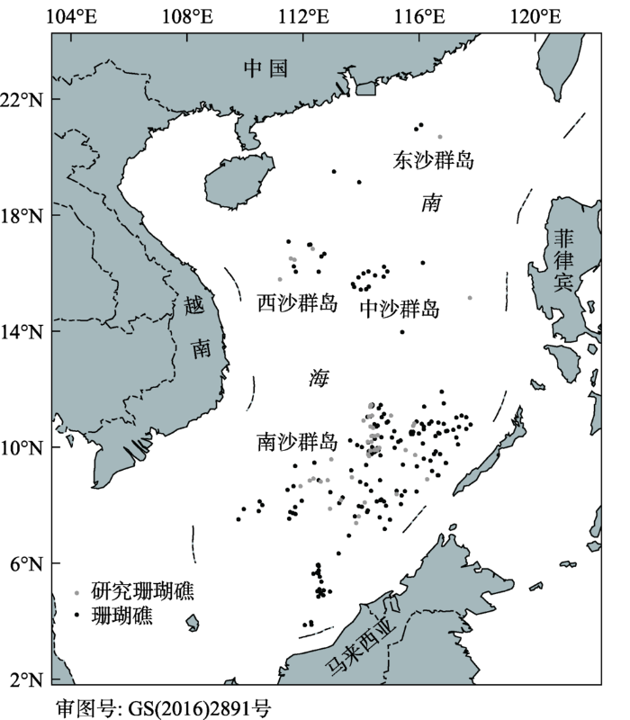
中国南海是太平洋最西部的边缘海,地处2°45´S~23°24´N,99°9´E~121°11´E,发育了数百个珊瑚礁(以环礁为主)。南海诸岛珊瑚礁包括东沙群岛、西沙群岛、中沙群岛和南沙群岛四大群岛。其中,南沙群岛珊瑚礁面积最大、珊瑚生长最繁盛,长期以来在中国的海洋生物多样性维持、海产资源供给和国防建设等方面发挥着重大作用。然而,由于远离大陆,开展珊瑚礁实地调查需要大量的人力、物力以及经费投入,时间成本高。同时,随着南海地区丰富的油气资源和海洋资源的发掘,由于其海洋资源丰富和战略地位重要,南海诸岛主权争端也不断升级。一个系统完备的遥感地貌分类体系指导生成的南海珊瑚礁地貌图将有助于我国南海珊瑚礁态势演变分析、管理和保护,将为维护南海诸岛在“一带一路”中国家主权权益做出应有的贡献。
珊瑚礁地貌以大尺度的地质结构为支撑,受气候环境组分和海洋过程控制,并结合生物反馈形成了发育良好的、可以清晰识别的地貌单元。目前珊瑚礁地貌分类体系主要基于地形、物种的丰富度和空间覆盖度进行构建(Goreau, 1959; Loya, 1972; Goldberg, 1973; Robert et al, 1973; 赵焕庭等, 1996)。以礁体位置、地形和动力环境为划分标准,典型的珊瑚礁地貌分类体系一级类型包括礁前、礁脊、礁坪、礁后和潟湖,然而不同的研究者之间也存在差异性。二级地貌类型的划分标准中多综合生境特征,因此命名多元化(表1)。例如,Goreau等(1959)将牙买加岸礁按结构分为2等级11类;Robert等(1973)从1968年夏到1970年3月调查了西印度浅水区38种珊瑚的分布与数量,将调查区地貌分为1级10类(限于利用水下呼吸器到达的深度)。中国于20世纪60年代初与苏联专家合作对海南岛的岸礁进行了研究,划分为封闭潟湖和封闭湾2类(纳乌莫夫等, 1960)。曾昭璇(1982)总结了中国环礁的类型和地貌特征,将环礁地貌划分为3等级10类。赵焕庭等(1992)将南沙群岛“腹地环礁”微地貌-沉积相带分为2等级10类。之后珊瑚礁动力地貌得到关注,以珊瑚礁区表层沉积物的粒度、生物组分、矿物成分和化学成分,并结合地貌学、岩石学综合分析,南海环礁地貌—沉积相带被分为广为使用的2等级14类(孙宗勋等, 1996; 赵焕庭等, 1996)。
表1 实地调查和高分辨率遥感影像构建的地貌分类体系
Tab.1 Geomorphic classification schemes based on field survey and high-resolution remote sensing images
| 地貌体系 | 文献 | 等级 | 指标 | 类型 |
|---|---|---|---|---|
| 实地调查 | Goreau, 1959 | 2级 | 一级:所处礁体位置、动力环境;二级:所处礁体位置、动力环境、生境 | 礁后:海岸带、潟湖;礁脊:邻近潟湖带、礁坪、波浪带、贫瘠带、混合带、扶壁带;向海坡:礁前、礁前斜坡、深礁前带,共11类。 |
| Robert等, 1973 | 1级 | 所处礁体位置、动力环境、生境 | 海岸带;潟湖;礁后;礁坪;鹿角珊瑚带;贫瘠带;混合带;辐板轴孔珊瑚带;礁前斜坡带;深礁前斜坡带,共10类。 | |
| 曾昭璇, 1982 | 3级 | 所处礁体位置、动力环境 | 礁坡区; 礁盘区:外礁盘、堤滩、次成潟湖、沙岛区(海滩岩、沙堤带、中部洼地);潟湖区:点礁,共9类。 | |
| 赵焕庭等, 1992 | 2级 | 所处礁体位置、动力环境 | 向海坡:下坡、上坡;外礁坪:礁缘坡、突起带、凹凸斑带;内礁坪:礁原带、礁坑带;潟湖:潟湖坡、潟湖底、点礁,共10类。 | |
| 孙宗勋等, 1996; 赵焕庭等, 1996 | 2级 | 一级:所处礁体位置、动力环境;二级:所处礁体位置、动力环境、生境 | 向海坡(礁缘坡);外礁坪;礁凸起;内礁坪:珊瑚稀疏带、珊瑚丛林带、礁坑发育带;潟湖:潟湖坡、潟湖盆、点礁。礁坪上发育沙洲和灰沙岛,灰沙岛:海滩、沙堤、沙席、洼地,共14类。 | |
| 高分辨率 遥感影像 | Mumby等, 1999 | 2级 | 一级:所处礁体位置、动力环境;二级:所处礁体位置、动力环境、生境 | 礁后;礁脊;潮沟:低潮沟、高潮沟;礁前;陡斜坡;点礁:浓密点礁、分散点礁;潟湖层:浅潟湖层、深潟湖层,共10类。 |
| Leon等, 2011 | 2级 | 一级:所处礁体位置;二级:所处礁体位置、生境 | 礁前;礁脊;礁坪:珊瑚带、砂为主的礁坪、海草床、植被沙洲;潟湖:砂为主的礁后、潟湖点礁、深潟湖;点礁,共10类。 | |
| Phinn等, 2012 | 1级 | 所处礁体位置 | 礁坡;礁脊;外礁坪;内礁坪;浅潟湖;深潟湖;共6类。 | |
| 龚剑明等, 2014 | 2级 | 一级:所处礁体位置、动力环境、生境;二级:所处礁体位置、动力环境 | 水下礁脊;外礁坪;礁凸起带;附礁生物稀疏带;附礁生物丛生带;礁坑发育带;潟湖:潟湖坡、潟湖底;点礁;潮汐通道;沙洲;灰沙岛:海滩、沙堤、沙席、洼地,共15类。 | |
| 周旻曦等, 2015 | 2级 | 一级:水深条件、沉积环境;二级:生物物理作用 | 向海坡;礁前;礁坪:礁脊、槽沟、珊瑚生长带、礁坑发育带;潟湖:潟湖坡、潟湖盆、潟湖点礁;潮汐通道;暗沙/暗滩;灰沙岛:海滩、沙丘,共13类。 | |
| 朱海天等, 2015 | 2级 | 一级:所处礁体位置、动力环境;二级:所处礁体位置、动力环境、生境 | 参考赵焕庭(1996),获取外礁缘;外礁坪;礁突起带;内礁坪:生物稀疏带、生物密集带、礁坑发育带;潟湖:潟湖坡、潟湖盆、点礁;沙洲,共10类。 | |
| Xu等, 2016 | 2级 | 一级:所处礁体位置,是否出露;二级:所处礁体位置、动力环境 | 环礁地貌分为潟湖:潟湖水体,潟湖点礁,点礁陆地;礁环:礁前,礁坪,浅台地,潮汐通道,礁环陆地,封闭潟湖;沉没环礁,共10类。 |
由于珊瑚礁一般形成于较浅和干净的水中,光学遥感是珊瑚礁地貌制图的理想技术(Leon et al, 2011; Roelfsema et al, 2018),弥补了传统潜水实地调查成本高、费时费力、观测点不足的局限性。遥感技术的发展推动了珊瑚礁从早期的Landsat-1到目前高分辨率影像地貌制图的成功应用,例如在大堡礁(Ahmad et al, 1994)、加勒比海(Andréfouët et al, 2005)、印度洋(Naseer et al, 2004)和太平洋(Phinn et al, 2012)的研究。在珊瑚礁遥感地貌制图中,珊瑚礁遥感地貌分类体系与实地调查建立的地貌分类体系相似:一级地貌类型通常以所处礁体位置、动力环境为指标;二级地貌类型划分指标中常综合生境类型(珊瑚区、海草床等),命名多元化(Mumby et al, 1999; Leon et al, 2011; Phinn et al, 2012; 龚剑明等, 2014; 周旻曦等, 2015; 朱海天等, 2015; Xu et al, 2016) (表1)。热带海洋中的珊瑚岛为石灰质的砂和砂砾堆积物,全部由来自周围礁坪的碳酸盐沉积物组成,是人类和鸟的栖息地,在社会—经济及生态中非常重要(Roy et al, 1991; Fuentes et al, 2011; Perry et al, 2011; 赵美霞等, 2017)。然而,在珊瑚礁遥感地貌分类体系中珊瑚岛通常被划分为礁坪的次级类型(Leon et al, 2011),不能凸显其重要性。此外,通过高分辨率遥感影像可以从大尺度上识别更多的地貌类型,且不同的珊瑚礁涵盖的地貌类型均有差异。珊瑚礁遥感地貌分类体系构建中纳入的珊瑚礁越多,遥感地貌分类体系涵盖的地貌类型就越完备,适用性越强。迄今为止尚缺乏一个尽可能完备的遥感地貌分类体系指导珊瑚礁遥感地貌制图。
因此,针对目前珊瑚礁遥感地貌分类体系中构建标准不统一、部分地貌类型重要性不突出以及涵盖的地貌类型不完备等问题,本文采用南海诸岛46个珊瑚礁(环礁、台礁)的高分辨率遥感数据(WorldView-2、Quickbird),并结合西沙群岛15个岛礁的地貌实地调查数据,在制定统一分级标准、突出重要地貌类型的基础上,构建完备的南海珊瑚礁高分辨率遥感地貌分类体系,从而服务于国家珊瑚礁生态系统的管理、保护与主权维护,并对海洋地貌学科的发展与完善也具有重要意义。
珊瑚礁地貌制图多采用光学遥感,传感器的光谱分辨率和空间分辨率决定了可识别的地貌类型。Green等(1996)为珊瑚礁生境识别定义了“描述分辨率”,即低分辨率可能仅识别出珊瑚礁,而高分辨率会区分出不同的珊瑚物种。对于珊瑚礁地貌类型,“描述分辨率”同样适用,即遥感影像分辨率越高,可区分出的地貌类型就越多。因此“描述分辨率”具有多等级多尺度的特点,此处的尺度是指地貌类型在不同空间分辨率遥感影像上的反映。本文基于“描述分辨率”建立南海珊瑚礁遥感地貌分类体系。
由于地貌类型有明确的界限,沿着坡度通常会呈现一些变化(如深度)(Houston, 1994),虽然在没有实地调查的情况下通过遥感影像可直接解译(Mumby et al, 1999)。但在不同传感器的制图能力方面,中分辨率遥感影像(TM,Landsat)可划分出珊瑚礁大的地貌类型(礁前、礁脊、礁坪和潟湖)(Green et al, 1996; Mumby et al, 2004; Andréfouët et al, 2006),高分辨率的传感器如IKONOS,Quickbird等可识别出更详细的地貌类型。高分辨率传感器自IKONOS (多光谱分辨率4 m,全色分辨率1 m)到Quickbird(多光谱分辨率2.44m,全色分辨率0.61m)等被证实可识别出更详细的地貌类型,面积较小的、斑块状的以及窄条带状的浅水地貌类型(<5 m)均能清晰的区分出来(Maeder et al, 2002; Mumby et al, 2002; Andréfouët et al, 2003; Phinn et al, 2012) 。
本文基于南海诸岛46幅环礁和台礁的WorldView-2、Quickbird高分辨率遥感影像构建南海珊瑚礁遥感地貌分类体系,所涉及珊瑚礁见图1和表2,遥感影像参数见表3。研究岛礁在东沙群岛、西沙群岛、中沙群岛和南沙群岛都有分布,对南海诸岛珊瑚礁有较好的代表性。参考已有珊瑚礁遥感地貌分类体系研究以及赵焕庭(1996)等对南海珊瑚礁地貌的系统研究,首先依据专家知识对高分辨率遥感影像中可识别的珊瑚礁地貌类型进行解译。地貌类型解译过程中应尽量避免冗余,例如环礁礁坪上发育的岛和台礁的岛均解译为灰沙岛,而不区分其所属的珊瑚礁类型。
图1 南海诸岛及研究珊瑚礁分布图
Fig.1 Offshore archipelagos in the South China Sea and the distribution of the studied coral reefs
表2 南海46个珊瑚礁的类型及分布
Tab.2 Type and status of 46 coral reefs
| 环礁 | 台礁 | |
|---|---|---|
| 西沙群岛 | 永兴岛、中建岛、琛航岛、甘泉岛 | |
| 东沙群岛 | 东沙岛 | |
| 中沙群岛 | 黄岩岛 | |
| 南沙群岛 | 奈罗礁(越占)、渚碧礁、铁峙礁、双黄沙洲(菲占)、南薰礁、舶兰礁(越占)、赤瓜礁、鬼喊礁(越占)、东门礁、西门礁、安乐礁、牛轭礁、华阳礁、东礁(越占)、西礁(越占)、中礁(越占)、仁爱礁(菲占)、司令礁(菲占)、永暑礁、美济礁、弹丸礁(马占)、毕生礁(越占)、柏礁(越占)、光星仔礁(马占)、簸箕礁(马占)、半月礁 | 北子岛(菲占)、南子岛(越占)、中业岛(菲占)、南钥岛(菲占)、太平岛、鸿庥岛(越占)、敦谦沙洲(越占)、染青沙洲(越占)、景宏岛(越占)、西月岛(菲占)、费信岛(菲占)、马欢岛(菲占)、南威岛(越占)、安波沙洲(越占) |
表3 高分辨率遥感影像参数表
Tab.3 Parameters of high-resolution remote sensing images
| 传感器 | 获取时间 | 波段 | 分辨率(星下点) | |
|---|---|---|---|---|
| 全色/m | 多光谱/m | |||
| Quickbird | 2001.10 | 全色+4多光谱波段 | 0.61 | 2.44 |
| WorldView-2 | 2009.10 | 全色+8多光谱波段 | 0.50 | 1.80 |
地貌类型解译方法为专家指导目视解译法。研究表明,地貌类型目视解译精度等于甚至大于自动分类精度,但当区域面积较大时自动解译法可节省时间(Franklin et al, 2003, Andréfouët et al, 2005)。在ENVI软件方面,通过Transform功能将高分辨遥感影像的多光谱波段与全色波段融合以辅助解译,融合后的遥感影像既具有高空间分辨率又具有丰富的光谱信息。因蓝绿波段在水中穿透性较好,地貌类型判读主要采用真彩色影像(红、绿、蓝波段合成)。地貌类型的解译采用自上而下的划分方法,即先划分大的地貌类型如水下礁脊、向海坡、外礁坪、礁凸起、内礁坪、潟湖、沙洲、灰沙岛;然后在每一个大的地貌类型内再解译次级地貌类型,如潟湖进一步划分为潟湖坡、潟湖底、点礁和潮汐通道。
珊瑚礁地貌类型清晰、准确的描述非常重要,可避免地貌制图中的混淆解译,为地貌等级的划分提供基础,还可指导珊瑚礁管理。本文珊瑚礁地貌类型描述采用的指标包括形态、动力特征、出露程度和沉积类型,这些指标可反映出珊瑚礁地貌形成的海洋过程和动力因素(Hamylton et al, 2016; Kayanne et al, 2016; Shen et al, 2018)。基于上述指标,结合已有研究,对46幅高分辨率遥感影像中解译出的所有岛礁地貌类型进行描述。为了验证珊瑚礁地貌类型描述的准确性,2014年6月对西沙群岛永兴岛、石岛、玉琢礁、盘石屿、华光礁、羚羊礁、筐仔沙洲、甘泉岛、全富岛、银屿、鸭公岛、七连屿(西沙洲、赵述岛、北岛、南沙洲)的15个岛礁开展了地貌类型实地调查,采集了珊瑚礁不同地貌类型的水下断面影像、水深数据、土壤和植被样本等。
南海46幅珊瑚礁高分辨率遥感影像中共解译出地貌类型19类,各地貌类型及结合实地调查的地貌类型描述见表4。地貌类型的描述中有的仅适用于南海珊瑚礁,如海藻脊;有的适用于全球大部分珊瑚礁,如礁坡。本文新命名了内礁坪生物稀疏带和内礁坪生物丛生带2个地貌类型,补充了水下礁脊、内礁坪潮间带浅滩、浅水礁塘地貌类型。内礁坪生物稀疏带邻近礁凸起带,为环礁和台礁礁坪中普遍存在的一个地貌类型(Zuo et al, 2017)。该带珊瑚覆盖度很低,调查的西沙群岛造礁珊瑚平均覆盖度仅为6.73%。内礁坪生物丛生带靠近潟湖坡,主要出现在环礁较宽阔的北侧礁坪,珊瑚覆盖度非常高,调查的西沙群岛造礁珊瑚平均覆盖度可达44.7%。地貌等级依据各地貌类型在珊瑚礁上的相对位置(由外海到内部潟湖或灰沙岛),综合考虑动力特征、出露程度、沉积类型特征,将相似尺度、相同重要性的地貌类型归为同等级别,并将沙洲、灰沙岛地貌类型作为第一等级进行划分。
表4 南海珊瑚礁高分辨率遥感地貌分类体系
Tab.4 Geomorphic classification scheme for coral reefs in the South China Sea based on high-resolution satellite images
| 1级 | 2级 | 3级 | 说明 | 形态 | 动力 特征 | 出露 程度 | 沉积 类型 | ||||||
|---|---|---|---|---|---|---|---|---|---|---|---|---|---|
| 代码 | 地貌 | 代码 | 地貌 | 代码 | 地貌-生物 | ||||||||
| 1 | 水下礁脊 | 大环礁不出露礁坪 | 低潮不出露 | 繁生珊瑚和钙藻等造礁生物以及贝类 | |||||||||
| 2 | 礁前斜坡(向海坡) | 2.1 | 礁前斜坡下坡 | 大于700~900 m, 坡度稍缓 | 切割起伏型 | ||||||||
| 2.2 | 礁前斜坡上坡 | 700~900 m以内, 较陡 | 平直型 | ||||||||||
| 3 | 礁坪 | 3.1 | 外礁坪 | 槽沟发育带 | 高波 能带 | 低潮几乎 全部干出 | 覆盖大量生物碎屑物,珊瑚生长较差 | ||||||
| 3.2 | 礁凸起带 | 海藻脊,无活珊瑚 | 低潮完全 干出 | 珊瑚藻,生物碎屑多为砾石 | |||||||||
| 3.3 内礁坪 | 3.3.1 | 生物稀 疏带 | 稀疏的珊瑚、附礁生物 | 低波 能带 | 薄层海水 | 积水洼地底部堆积松散的厚约1 cm的生物砂屑 | |||||||
| 3.3.2 | 潮间带 浅滩 | 无珊瑚等生物, 砂砾混合堆积物 | 丘状或条 带状 | 低潮出露 | 白色的生物质砂砾混合 堆积 | ||||||||
| 3.3.3 | 生物丛 生带 | 抗浪性差的珊瑚和附礁生物茂盛 | 低潮不出露 | 粗砂、细砂等生物碎屑 | |||||||||
| 3.3.4 | 礁坑发 育带 | 深而大的礁坑, 坑壁繁生珊瑚 | 起伏最大 | 低潮不出露 | 几厘米的白色生物砂、含生物砾块 | ||||||||
| 4 | 潟湖 | 4.1 | 潟湖坡 | 水深较浅 | 低潮不出露 | 生物碎屑物以粗砂为主 | |||||||
| 4.2 | 潟湖底 | 低潮不出露 | 生物碎屑物主要是中细砂、粉砂质砂 | ||||||||||
| 4.3 | 点礁 | 潟湖底或潟湖坡上 | 峰丘型 | 低潮不出露 | |||||||||
| 礁坪型 | 低潮出露 | ||||||||||||
| 4.4 | 潮汐 通道 | 即口门,流急 | 直通式 | 高波 能带 | 一般无碎屑沉积物 | ||||||||
| 门槛式 | |||||||||||||
| 5 | 浅水礁塘 | 礁坪上常积水的低洼地 | 低潮不出露 | 生物质的砂砾为主 | |||||||||
| 6 | 沙洲 | 没有或很少植物 | 不稳定 | 高潮出露 | 松散的珊瑚砂砾、贝壳碎屑和其他生物碎屑 | ||||||||
| 7 | 灰沙岛 | 7.1 | 海滩 | 不长植物 | 潮间带 | 中砂为主,各类高潮线粗砂和砾含量较高。分选中等-差 | |||||||
| 7.2 | 沙堤 | 植被繁茂,有高脊 | 环状 | 高潮出露 | 粗中砂、砾石含量极少,分选中等 | ||||||||
| 7.3 | 沙席 | 植被优良,低地 | 粗中砂、砾石含量极少,分选中等 | ||||||||||
| 7.4 | 洼地 | 涉水而过,无大的 树木 | 中砂、细砂为主 | ||||||||||
根据所处礁体位置、形态、动力特征、出露程度、沉积类型等差异,本文共将地貌类型划分3个等级,第一等级:自海向澙湖或灰沙岛,包括:水下礁脊、礁前斜坡(向海坡)、礁坪、潟湖、浅水礁塘、沙洲、灰沙岛;第二等级:礁前斜坡下坡、礁前斜坡上坡、外礁坪、礁凸起带、内礁坪、潟湖坡、潟湖底、点礁、潮汐通道、海滩、沙堤、沙席、洼地;第三等级:内礁坪生物稀疏带、内礁坪潮间带浅滩、内礁坪生物丛生带、内礁坪礁坑发育带(表4)。其中第一等级和第二等级以所处礁体位置和动力环境为分类标准,第三等级以所处礁体位置、动力环境和生境(珊瑚、海藻等生物的多少)为分类标准。
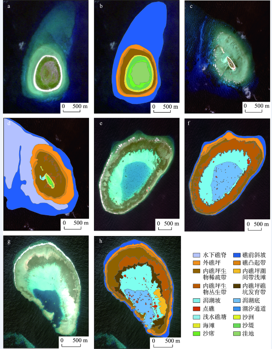
以构建的南海珊瑚礁高分辨率遥感地貌分类体系为指导,对南海46个珊瑚礁进行高分辨率遥感地貌制图,制图过程中从外海向潟湖或灰沙岛按照等级依次划分地貌类型。本文以西沙群岛甘泉岛(16°36′N, 111°35′E)、南沙群岛敦谦沙洲(10°23′N, 114°28′E)、南沙群岛簸箕礁(8°7′N, 114°10′E)和南沙群岛安乐礁(9°56′N, 114°31′E)的高分辨率遥感地貌制图结果进行展示。由于光学遥感在最清澈的水中最大穿透深度仅为25 m(Mumby et al, 1999),因此礁前斜坡(向海坡)只绘制到遥感可以识别的范围内,即礁前斜坡上坡,实际的礁前斜坡比此范围要大。高分辨率遥感影像中解译出的上述4个礁的地貌类型可涵盖南海珊瑚礁遥感地貌分类体系中的所有类型(图2)。
图2 南海珊瑚礁高分辨率遥感影像地貌制图
(a. 甘泉岛遥感影像 b. 甘泉岛地貌图 c. 敦谦沙洲遥感影像 d. 敦谦沙洲地貌图 e. 簸箕礁遥感影像 f. 簸箕礁地貌图 g. 安乐礁遥感影像 h. 安乐礁地貌图)
Fig.2 Geomorphic mapping of coral reefs in the South China Sea based on high-resolution satellite images
(a. Ganquan Island satellite image, b. Ganquan Island geomorphic map, c. Dunqian Cay satellite image, d, Dunqian Cay geomorphic map, e. Boji Reef satellite image, f. Boji Reef geomorphic map, g. Anle Reef satellite image, h. Anle Reef geomorphic map)
图2表明珊瑚礁地貌类型多样,珊瑚礁之间均存在差异性,单个或少数珊瑚礁地貌类型所构建的遥感地貌分类体系代表性较差。本文综合46个南海珊瑚礁高分辨率遥感影像,补充了水下礁脊、内礁坪潮间带浅滩、浅水礁塘等地貌类型,构建的遥感地貌分类体系更完备,在地貌类型较多的珊瑚礁地貌制图中应用性更好,如敦谦沙洲。与构建的遥感地貌分类体系相对应,通过地貌图可以统计每个地貌类型的长、宽、面积等属性及空间分布状况,根据其动力特征、出露程度、沉积类型等指标,推断作用于地貌类型的海洋动力过程。地貌图中将灰沙岛作为一级地貌类型(如甘泉岛和敦谦沙洲),相比仅将其作为礁坪的次级类型,该地貌分类体系突出了珊瑚礁当前所处的演化阶段,为人类提供了生存条件,对社会经济具有重要的意义。敦谦沙洲地貌图中也表明西北侧礁坪中沙洲的形成值得关注。此外,内含珊瑚覆盖度信息的内礁坪生物稀疏带和生物丛生带在每个珊瑚礁的空间分布和面积,对珊瑚礁的调查、管理和保护具有重要的意义。
基于南海46个珊瑚礁(环礁、台礁)的高分辨率遥感影像,本文构建了3级19类的南海珊瑚礁地貌分类体系并制图。与前人实地调查以及基于高分辨率遥感影像构建的地貌分类体系(表1)相比,此遥感地貌分类体系不仅等级最多,涵盖的地貌类型数量也最多。同时,遥感地貌分类体系构建中采用的分级标准更统一,第一等级和第二等级均以所处礁体位置和动力环境进行划分,第三等级包含少量生境信息进行划分。每个地貌类型均结合实地调查对其形态、动力特征、出露程度、沉积类型进行了描述,保证了遥感地貌分类体系的尽可能完备和系统。
其次,将沙洲和灰沙岛作为一级地貌类型,并与水下礁体部分共同构建遥感地貌分类体系,相比目前国外珊瑚礁地貌分类体系中将水下礁体和水上的灰沙岛相区分的研究(Phinn et al, 2012),以及仅将沙洲或灰沙岛作为礁坪的次级类型的研究(Leon et al, 2011),可以明确珊瑚礁演化的最终阶段,突出了沙洲和灰沙岛的重要性。
此外,南海珊瑚礁遥感地貌分类体系构建中命名了内礁坪生物稀疏带和内礁坪生物丛生带,补充了水下礁脊、潮间带浅滩、浅水礁塘等类型,使得南海珊瑚礁地貌分类体系更为完备。在实地调查中发现,内礁坪生物稀疏带珊瑚覆盖度较低,而内礁坪生物丛生带珊瑚覆盖度较高。由于大量的研究表明,珊瑚覆盖度在解释专门以珊瑚栖居的物种、鱼的丰富度和依赖珊瑚生境进行繁殖的物种中具有非常重要的作用(Munday, 2002; Pratchett et al, 2006; Komyakova et al, 2013),因此这2个带以生物稀疏带和生物丛生带进行命名,表明珊瑚和生物的分布。浅水礁塘为礁坪上常积水的很浅的低洼地,沉积物多以生物质的砂砾为主,与潟湖坡颜色相近,可作为与潟湖并列的地貌单元,也可能是潟湖发育的下一个阶段,在分析中推断其有几种不同的成因:一是潟湖演变至衰退阶段,生物碎屑堆积变浅,成浅水礁塘,如南沙群岛华阳礁中部不规则浅水礁塘,也可称残存潟湖;二是海滩外侧礁坪内缘低洼地,退潮后仍积水形成环滩分布的浅水礁塘;三是当沙堤堆积之初,沙堤围圈的礁坪低洼地积水为浅水礁塘,随沙席的扩展,礁塘萎缩消亡。珊瑚礁中浅水礁塘的类型可结合珊瑚礁整体地貌特征进行判别。
遥感地貌分类体系中的地貌单元均与实地调查对照,建立了高分辨率遥感影像解译标志,表明该遥感地貌分类体系应用于南海珊瑚礁遥感地貌制图的可行性。同时,本文所建立的遥感地貌等级体系反映出遥感传感器的制图能力,可满足不同的用户需求和遥感数据源。低等级的地貌类型适用于高分辨率影像和航空影像地貌制图,高等级的地貌类型适用于空间尺度在数十米的卫星影像地貌制图。
南海珊瑚礁高分辨率遥感地貌等级分类体系适用于目前大多数南海珊瑚礁遥感地貌制图,但是遥感本身的一些局限性可能影响基于该遥感地貌分类体系的制图。首先,光学遥感在最清澈的水中最大穿透深度仅为25 m(Mumby et al, 1999),因此所建立的地貌体系适用性不超过此深度范围。南海发育了众多的暗礁、暗沙、暗滩,其动力特征、出露程度、沉积类型与低潮出露珊瑚礁存在着差异性(王黎等, 2018),由于遥感穿透性的制约,这些暗礁等的地貌单元需作进一步研究。
其次,由于珊瑚礁遥感影像获取时受到潮汐、大气、水柱的影响,同一珊瑚礁的不同位置或不同珊瑚礁的相同地貌类型都存在差异性,因此本文建立的地貌体系是一个定性而非定量的标准,在应用过程中可以与实地相结合,给定标准。
此外,各因素共同作用形成的地貌类型的水动力及沉积等特征存在区域性,当依据南海自然环境建立的遥感地貌分类体系应用到全球其他区域的珊瑚礁时,还应根据当地的环境进行具体分析。
本文基于目前珊瑚礁遥感地貌分类体系的构建标准、合理性及完备性等方面存在的一些不足,应用中国南海46个珊瑚礁(环礁、台礁)的高分辨率遥感影像,结合西沙群岛15个岛礁的地貌实地调查数据进行南海高分辨率遥感地貌分类体系的构建研究。研究的主要结论为:
(1) 基于所处礁体位置、动力特征、出露程度和沉积类型,提出自海向内部潟湖或灰沙岛方向的3级珊瑚礁高分辨率遥感地貌分类体系。第一等级和第二等级均以所处礁体位置和动力环境为划分标准,第三等级包含少量生境信息进行划分,解决了构建标准不统一、命名多元化的问题。同时,将沙洲和灰沙岛作为一级地貌类型,明确了珊瑚礁演化的最终阶段,突出了沙洲和灰沙岛的重要性。其多等级多尺度性适用于分辨率由低到高的遥感影像地貌制图,可满足不同的用户需求。
(2) 采用自上而下的地貌类型划分方法,共解译出地貌类型19类。命名了内礁坪生物稀疏带和生物丛生带2个地貌类型,内含珊瑚和生物的覆盖度信息,对珊瑚礁的调查、管理和保护具有重要意义;补充了水下礁脊、内礁坪潮间带浅滩、浅水礁塘地貌类型,使得遥感地貌分类体系更加完备,便于直观理解和推断不同尺度的海洋和生态相互作用过程。
本文研究表明,完备的遥感地貌分类体系的构建可通过采用多个珊瑚礁的高分辨率遥感影像获取地貌类型的方法而实现,构建的遥感地貌分类体系在地貌类型越多的珊瑚礁地貌制图中应用性越强。当将该遥感地貌分类体系应用于整个南海的环礁和台礁时,需进一步根据具体珊瑚礁的水动力环境及沉积特征对地貌类型描述进行验证。应用验证后的遥感地貌分类体系指导生成的南海珊瑚礁地貌产品将在珊瑚礁保护和管理等方面发挥重要作用,例如显示各地貌单元的组分、监测地貌的演变、评估适宜珊瑚生长的区域、辅助珊瑚礁白化监测和长棘海星控制,以及辅助珊瑚礁生物生态模拟等方面。
未来的研究将关注南海暗礁、暗沙、暗滩等的遥感地貌分类体系构建工作,由于受遥感穿透性的制约,目前对这些珊瑚礁的地貌研究尚处于空白。
The authors have declared that no competing interests exist.
| [1] |
面向对象的南海珊瑚礁地貌单元提取 [J].https://doi.org/10.3724/SP.J.1047.2014.00997 Magsci [本文引用: 1] 摘要
<p>南海珊瑚礁地貌信息的提取是珊瑚礁资源利用、生态保护与管理及可持续发展的重要地学基础。本文提出了面向对象的珊瑚礁地貌单元提取模型, 针对不同的地貌单元, 以不同地貌单元的最优分割尺度、光谱参数、形状参数来分割影像并合并成不同对象, 从而获得相应的地貌单元。通过大量实验得出自然地貌的最优分割尺度区间为[140,600], 其中附礁生物稀疏带及丛生带、礁坑发育带的光谱参数和形状参数分别为0.9 和0.1, 其他自然地貌单元的光谱参数和形状参数分别为0.8 和0.2; 人工地貌的最优分割尺度区间为[25,170], 其光谱参数和形状参数分别为0.8 和0.2。进一步以南沙群岛簸箕礁WorldView-2 高分辨率遥感影像为例提取地貌单元, 并结合混淆矩阵和Kappa 系数对分类结果进行了精度评价, 地貌单元提取总体精度达到了85.75%, Kappa 系数为0.8349。结果表明, 该方法可有效运用南海珊瑚礁遥感影像的光谱特征、纹理特征, 以及影像数据不同波段的组合特性, 综合了影像和珊瑚礁地貌的关联特性, 充分利用了珊瑚礁不同地貌相带的异质性, 获得了理想的南海珊瑚礁地貌的整体信息, 满足了我国南海珊瑚礁地貌信息提取和地貌数字产品生成的需求。</p>
A study on the object-oriented model for geomorphic unit extraction of coral reefs in the South China Sea [J].https://doi.org/10.3724/SP.J.1047.2014.00997 Magsci [本文引用: 1] 摘要
<p>南海珊瑚礁地貌信息的提取是珊瑚礁资源利用、生态保护与管理及可持续发展的重要地学基础。本文提出了面向对象的珊瑚礁地貌单元提取模型, 针对不同的地貌单元, 以不同地貌单元的最优分割尺度、光谱参数、形状参数来分割影像并合并成不同对象, 从而获得相应的地貌单元。通过大量实验得出自然地貌的最优分割尺度区间为[140,600], 其中附礁生物稀疏带及丛生带、礁坑发育带的光谱参数和形状参数分别为0.9 和0.1, 其他自然地貌单元的光谱参数和形状参数分别为0.8 和0.2; 人工地貌的最优分割尺度区间为[25,170], 其光谱参数和形状参数分别为0.8 和0.2。进一步以南沙群岛簸箕礁WorldView-2 高分辨率遥感影像为例提取地貌单元, 并结合混淆矩阵和Kappa 系数对分类结果进行了精度评价, 地貌单元提取总体精度达到了85.75%, Kappa 系数为0.8349。结果表明, 该方法可有效运用南海珊瑚礁遥感影像的光谱特征、纹理特征, 以及影像数据不同波段的组合特性, 综合了影像和珊瑚礁地貌的关联特性, 充分利用了珊瑚礁不同地貌相带的异质性, 获得了理想的南海珊瑚礁地貌的整体信息, 满足了我国南海珊瑚礁地貌信息提取和地貌数字产品生成的需求。</p>
|
| [2] |
海南岛珊瑚礁的主要类型 [J].Hainandao shanhujiao de zhuyao leixing [J]. |
| [3] |
南沙群岛珊瑚礁的动力地貌特征 [J].
南沙群岛受季风、台风和波浪的影响,珊瑚礁体呈NE-SW向椭圆形态,西南礁坪宽于东北礁坪。位于不同波能带内的珊瑚礁体发育了与之相适应的动力地貌单元。礁前斜坡高波能带地形陡峭,向风坡礁脊一槽沟系发育。外礁坪消耗大量波能,广泛覆盖生物碎屑,珊瑚生长稀疏。内礁坪宽广平坦,珊瑚生长良好。外礁坪堆积许多大礁块,尤以东北礁坪为甚。在湖低波能带,通常东坡缓于百坡,湖盆一般浪静流缓,为生物碎屑堆积区。
Features of dynamic geomorphology of coral reefs in Nansha Islands [J].
南沙群岛受季风、台风和波浪的影响,珊瑚礁体呈NE-SW向椭圆形态,西南礁坪宽于东北礁坪。位于不同波能带内的珊瑚礁体发育了与之相适应的动力地貌单元。礁前斜坡高波能带地形陡峭,向风坡礁脊一槽沟系发育。外礁坪消耗大量波能,广泛覆盖生物碎屑,珊瑚生长稀疏。内礁坪宽广平坦,珊瑚生长良好。外礁坪堆积许多大礁块,尤以东北礁坪为甚。在湖低波能带,通常东坡缓于百坡,湖盆一般浪静流缓,为生物碎屑堆积区。
|
| [4] |
九章环礁水下暗礁脊槽地貌分布与形态 [J].Distribution and morphological characteristics of spur and groove on submerged reefs of Jiuzhang Atoll, South China Sea [J]. |
| [5] |
中国环礁的类型划分 [J].Zhongguo huanjiao de leixing huafen [J]. |
| [6] |
|
| [7] |
南沙群岛“危险地带”腹地珊瑚礁的地貌与现代沉积特征 [J].
<p>南沙群岛中央水道及南华水道两侧的珊瑚礁,大部分为环礁,分属开放型、半开放型、准封闭型、封闭型和台礁化型,反映了环礁向灰砂岛演变的不同阶段。每个环礁,从礁前斜坡向礁坪至潟湖,可相应划分出3种沉积相和细分9种沉积带。礁顶是全新世中期以来形成发育的。</p>
Geomorphic and modern sedimentary features of coral reefs in the hinterland of "dangerous ground": Nansha Islands [J].
<p>南沙群岛中央水道及南华水道两侧的珊瑚礁,大部分为环礁,分属开放型、半开放型、准封闭型、封闭型和台礁化型,反映了环礁向灰砂岛演变的不同阶段。每个环礁,从礁前斜坡向礁坪至潟湖,可相应划分出3种沉积相和细分9种沉积带。礁顶是全新世中期以来形成发育的。</p>
|
| [8] |
南沙群岛珊瑚礁自然特征 [J].
南沙群岛呈现典型的热带珊瑚礁群岛的景观,自第三纪中期以来,这里处于热带海洋气候条件下,热带海洋生物群性,造礁生物建造了珊瑚礁。全新世中期海面上涨至最高以来,礁坪亦到达目前位置,同时风浪不断将生物砾砂屑抛掷在礁顶上,堆积成灰沙岛,在常年基本处于恒温和恒雨量的条件下,岛屿沙土逐渐脱盐,外来植物登岛发芽,扎根,长成热带常绿乔灌林,在植物与岛栖鸟行为条件下发育了热带磷质石灰土壤,建议南沙群岛的自然区划为6
Nansha qundao shanhu jiao ziran tezheng [J].
南沙群岛呈现典型的热带珊瑚礁群岛的景观,自第三纪中期以来,这里处于热带海洋气候条件下,热带海洋生物群性,造礁生物建造了珊瑚礁。全新世中期海面上涨至最高以来,礁坪亦到达目前位置,同时风浪不断将生物砾砂屑抛掷在礁顶上,堆积成灰沙岛,在常年基本处于恒温和恒雨量的条件下,岛屿沙土逐渐脱盐,外来植物登岛发芽,扎根,长成热带常绿乔灌林,在植物与岛栖鸟行为条件下发育了热带磷质石灰土壤,建议南沙群岛的自然区划为6
|
| [9] |
珊瑚岛的动态演变及其稳定性研究综述 [J].https://doi.org/10.13284/j.cnki.rddl.002988 URL [本文引用: 1] 摘要
珊瑚岛是指发育在珊瑚礁的礁坪上,高潮时也不会被淹没的生物碎屑堆积体。珊瑚岛在珊瑚礁区广泛分布,可划分为无植被沙岛、无植被砾岛、有植被沙岛、有植被砾岛、有植被的沙砾岛、红树林岛和成熟的低林岛等7种类型,不同类型珊瑚岛的地貌特征存在差异。珊瑚岛受多种因素影响而在不同空间和时间尺度上处在动态变化中,珊瑚礁健康状况、珊瑚岛沉积特征、台风和海平面变化是影响珊瑚岛稳定性的重要因素。全球变化引起海水表面温度升高、海洋酸化、海平面上升及台风活动增强,直接或间接影响了珊瑚岛的沉积物供给、运移、堆积等动力学过程的各个方面,珊瑚岛的发展具有不确定性。迫切需要加强对珊瑚礁动态演变及其稳定性研究,建议从珊瑚岛的生物地貌动力学过程及全球变化对珊瑚岛动态演变的影响方面进行重点分析。
Review on the study of coral cay dynamics and its stability [J].https://doi.org/10.13284/j.cnki.rddl.002988 URL [本文引用: 1] 摘要
珊瑚岛是指发育在珊瑚礁的礁坪上,高潮时也不会被淹没的生物碎屑堆积体。珊瑚岛在珊瑚礁区广泛分布,可划分为无植被沙岛、无植被砾岛、有植被沙岛、有植被砾岛、有植被的沙砾岛、红树林岛和成熟的低林岛等7种类型,不同类型珊瑚岛的地貌特征存在差异。珊瑚岛受多种因素影响而在不同空间和时间尺度上处在动态变化中,珊瑚礁健康状况、珊瑚岛沉积特征、台风和海平面变化是影响珊瑚岛稳定性的重要因素。全球变化引起海水表面温度升高、海洋酸化、海平面上升及台风活动增强,直接或间接影响了珊瑚岛的沉积物供给、运移、堆积等动力学过程的各个方面,珊瑚岛的发展具有不确定性。迫切需要加强对珊瑚礁动态演变及其稳定性研究,建议从珊瑚岛的生物地貌动力学过程及全球变化对珊瑚岛动态演变的影响方面进行重点分析。
|
| [10] |
多目标珊瑚岛礁地貌遥感信息提取方法: 以西沙永乐环礁为例 [J].https://doi.org/10.11821/dlyj201504007 URL [本文引用: 1] 摘要
南海珊瑚岛礁资源极为丰富,实时、快速、高效、准确地获取大范围珊瑚岛礁地貌遥感信息具有现实意义。研究提出了一种双尺度转化下的模型与数据混合驱动的岛礁地貌信息提取框架,并设计了珊瑚岛礁地貌分类体系及相应技术流程:首先采用自上而下模型驱动的GVF Snake模型进行宏观地理分带的粗分割,然后采用自下而上数据驱动的云影极值抑制下多阈值OTSU分类算法进行微观地貌类型的精细分类,最终利用区域生长算法提取离散分布的暗沙、暗滩等浅水地貌单元。针对西沙永乐环礁利用CBERS-02B数据进行实验,精度验证表明:珊瑚岛礁地貌遥感信息提取方法总体精度优于经典数据驱动的监督分类算法,且具有抗噪能力强、顾及空间拓扑关系、自动灵活等特点。
Geomorphologic information extraction for multi-objective coral islands from remotely sensed imagery: A case study for Yongle Atoll, South China Sea [J].https://doi.org/10.11821/dlyj201504007 URL [本文引用: 1] 摘要
南海珊瑚岛礁资源极为丰富,实时、快速、高效、准确地获取大范围珊瑚岛礁地貌遥感信息具有现实意义。研究提出了一种双尺度转化下的模型与数据混合驱动的岛礁地貌信息提取框架,并设计了珊瑚岛礁地貌分类体系及相应技术流程:首先采用自上而下模型驱动的GVF Snake模型进行宏观地理分带的粗分割,然后采用自下而上数据驱动的云影极值抑制下多阈值OTSU分类算法进行微观地貌类型的精细分类,最终利用区域生长算法提取离散分布的暗沙、暗滩等浅水地貌单元。针对西沙永乐环礁利用CBERS-02B数据进行实验,精度验证表明:珊瑚岛礁地貌遥感信息提取方法总体精度优于经典数据驱动的监督分类算法,且具有抗噪能力强、顾及空间拓扑关系、自动灵活等特点。
|
| [11] |
基于随机森林的南沙岛礁分类方法研究 [C]//中国海洋学会. 中国海洋学会2015年学术论文集.Jiyu suiji senlin de Nansha daojiao fenlei fangfa yanjiu [C]//Chinese Society for Oceanography. Zhongguo haiyang xuehui 2015 nian xueshu lunwenji. |
| [12] |
An evaluation of Landsat Thematic Mapper (TM) digital data for discriminating coral reef zonation: Heron Reef (GBR) [J].https://doi.org/10.1080/01431169408954268 URL [本文引用: 1] 摘要
Coral reefs exhibit patterns of zonation. In this study we have evaluated the usefulness of Landsat-TM digital data as a tool for discrimination and mapping of reef zones. Classification, on bands 1, 2 and 3, and grouping of classes into reef zones was carried out with the aid of canonical variate analysis and minimum spanning trees. Thirteen reef zones can be identified and mapped, at a spatial scale relevant to their dimensions, with confidence. These zones can be further subdivided and mapped as spatially coherent subzones, in order to provide detailed information regarding the density of coral cover on the reef flat. In addition, the canonical variate analysis provides the basis for the aggregation of classes into sub-zones on interpreted primary productivity gradients, which is of relevance to coral reef management, monitoring and research.
|
| [13] |
Coral reef distribution, status and geomorphology-biodiversity relationship in Kuna Yala(San Blas) archipelago, Caribbean Panama [J].https://doi.org/10.1007/s00338-004-0444-4 URL [本文引用: 2] 摘要
Most of the knowledge of the reef geomorphology and benthic communities of Kuna Yala coral reefs (Caribbean Panama) comes from the western side of the archipelago, a few tens of kilometers around Punta San Blas (Porvenir). To bridge the gap between Porvenir and the Colombia–Panama border, we investigated with Landsat images the extent and geomorphological diversity of the entire Kuna Yala to provide geomorphologic maps of the archipelago in 12 classes. In addition to remote sensing data, in situ survey conducted in May–June 2001 provided a Kuna Yala-wide first synoptic vision of reef status, in terms of benthic diversity (number of species of coral, octocorals, and sponges) and reef health (coral versus algal cover). For a total reef system estimated to cover 63802km 2 along 48002km of coastline, 19502km 2 include coral dominated areas and only 3502km 2 can be considered covered by corals. A total of 69 scleractinian coral, 38 octocoral, and 82 sponge species were recorded on the outer slopes of reef formations, with a slightly higher diversity in the area presenting the most abundant and diverse reef formations (western Kuna Yala). Attempts to relate benthic diversity and geomorphological diversity provided only weak relationships regardless of the taxa, and suggest that habitat heterogeneity within geomorphological areas explain better the patterns of coral diversity. This study confirms the potential of combined remote sensing and in situ surveys for regional scale assessment, and we suggest that similar approaches should be generalized for reef mapping and assessment for other reef sites.
|
| [14] |
Multi-site evaluation of IKONOS data for classification of tropical coral reef environments [J].https://doi.org/10.1016/j.rse.2003.04.005 URL [本文引用: 1] 摘要
Ten IKONOS images of different coral reef sites distributed around the world were processed to assess the potential of 4-m resolution multispectral data for coral reef habitat mapping. Complexity of reef environments, established by field observation, ranged from 3 to 15 classes of benthic habitats containing various combinations of sediments, carbonate pavement, seagrass, algae, and corals in different geomorphologic zones (forereef, lagoon, patch reef, reef flats). Processing included corrections for sea surface roughness and bathymetry, unsupervised or supervised classification, and accuracy assessment based on ground-truth data. IKONOS classification results were compared with classified Landsat 7 imagery for simple to moderate complexity of reef habitats (5–11 classes). For both sensors, overall accuracies of the classifications show a general linear trend of decreasing accuracy with increasing habitat complexity. The IKONOS sensor performed better, with a 15–20% improvement in accuracy compared to Landsat. For IKONOS, overall accuracy was 77% for 4–5 classes, 71% for 7–8 classes, 65% in 9–11 classes, and 53% for more than 13 classes. The Landsat classification accuracy was systematically lower, with an average of 56% for 5–10 classes. Within this general trend, inter-site comparisons and specificities demonstrate the benefits of different approaches. Pre-segmentation of the different geomorphologic zones and depth correction provided different advantages in different environments. Our results help guide scientists and managers in applying IKONOS-class data for coral reef mapping applications.
|
| [15] |
Global assessment of modern coral reef extent and diversity for regional science and management applications: A view from space [C]//Suzuki Y, Nakamori T, Hidaka M, et al. 2004. |
| [16] |
Mapping and biomass estimation of the invasive brown algae Turbinaria ornata (Turner) J. Agardh and Sargassum mangarevense (Grunow) Setchell on heterogeneous Tahitian coral reefs using 4-meter resolution IKONOS satellite data [J].https://doi.org/10.1007/s00338-003-0367-5 URL [本文引用: 1] |
| [17] |
Benthic habitat mapping in the Tortugas Region, Florida [J].https://doi.org/10.1080/01490410306706 URL [本文引用: 1] 摘要
Concern about declining trends in coral reef habitats and reef fish stocks in the Florida Keys contributed to the implementation of a network of no-take marine protected areas in 1997. In support of the efforts of the Dry Tortugas National Park and Florida Keys National Marine Sanctuary to implement additional no-take areas in the Tortugas region in 2001, we expanded the scale of our fisheries independent monitoring program for coral reef fishes in the region. To provide a foundation for the habitat-based, stratified random sampling design of the program, we created a digital benthic habitat map of coral reef and hard-bottom habitats in a geographic information system by synthesizing data from bathymetric surveys, side-scan sonar imagery, aerial photogrammetry, existing habitat maps, and in situ visual surveys. Existing habitat maps prior to 1999 were limited to shallow-water (< 20 m depth) soft-sediment, coral reef, and hard-bottom habitats within Dry Tortugas National Park and did not include deeper areas such as the Tortugas Bank, now partially contained within no-take marine protected area boundaries. From diver observations made during the 1999 survey, we developed a classification scheme based on habitat relief and patchiness to describe nine hard-bottom and coral reef habitats encountered from 1-33 m depth. We provide estimates of area by habitat type for no-take marine protected areas in the Tortugas region. Updated information on the spatial distribution and characteristics of benthic habitats will be used to guide future monitoring, assessment, and management activities in the region. Significant data gaps still exist for the western area of the Florida Keys National Marine Sanctuary and are a priority for future research.
|
| [18] |
Vulnerability of sea turtle nesting grounds to climate change [J].https://doi.org/10.1111/j.1365-2486.2010.02192.x URL [本文引用: 1] 摘要
Abstract Given the potential vulnerability of sea turtles to climate change, a growing number of studies are predicting how various climatic processes will affect their nesting grounds. However, these studies are limited by scale, because they predict how a single climatic process will affect sea turtles but processes are likely to occur simultaneously and cause cumulative effects. This study addresses the need for a structured approach to investigate how multiple climatic processes may affect a turtle population. Here, we use a vulnerability assessment framework to assess the cumulative impact of various climatic processes on the nesting grounds used by the northern Great Barrier Reef (nGBR) green turtle population. Further, we manipulate the variables from this framework to allow users to investigate how mitigating different climatic processes individually or simultaneously can influence the vulnerability of the nesting grounds. Our assessment indicates that nesting grounds closer to the equator, such as Bramble Cay and Milman Island, are the most vulnerable to climate change. In the short-term (by 2030), sea level rise will cause the most impact on the nesting grounds used by the nGBR green turtle population. However, in the longer term, by 2070 sand temperatures will reach levels above the upper transient range and the upper thermal threshold and cause relatively more impact on the nGBR green turtle population. Thus, in the long term, a reduction of impacts from sea-level rise may not be sufficient, as rookeries will start to experience high vulnerability values from increased temperature. Thus, in the long term, reducing the threats from increased temperature may provide a greater return in conservation investment than mitigating the impacts from other climatic processes. Indeed, our results indicate that if the impacts from increased temperature are mitigated, the vulnerability values of almost all rookeries will be reduced to low levels.
|
| [19] |
The ecology of the coral-octocoral communities off the southeast Florida coast: Geomorphology, species composition, and zonation [J].
Three parallel submarine terraces found along the southeast coast of Florida, stretching from Miami through Palm Beach County, are described. The central portion of this area near southern Palm Beach County was analyzed with respect to geomorphology, community composition, and zonation from the low-tide mark to a depth of 50 m. Twenty-seven species of scleractinian corals and 39 species of gorgonians are found here and define a typical coral-reef community farther north than has been acknowledged. Gorgonian diversity is maximal at a depth of 15-20 m, while scleractinians are most diverse in shallower water. Studies of gorgonian biomass indicate a trend toward large numbers of small individuals in low-diversity environments, and a smaller number of larger individuals in higher-diversity environments. A mean density of 25.1 colonies/m 2 gives these reefs the highest concentration of gorgonians yet recorded in the Caribbean region.
|
| [20] |
The ecology of Jamaican coral reefs I. Species composition and zonation [J].https://doi.org/10.2307/1929924 URL [本文引用: 2] 摘要
ABSTRACT The objective of this paper is to develop a delamination model that can predict delamination growth in a new woven composite for orthopedic use. This composite material is obtained from a laminated composite woven by incorporating a natural organic load (granulates of date cores) which becomes hybrid composite. The composite is made of an organic matrix containing methyl methacrylate, a woven reinforcement including a reinforcing glass fiber and a fabric perlon having an absorbing role. The walk cycle has been used to determine the operating conditions of tibiae prosthesis. Hence, the deflection tests were validated by orthopedist experts. Three end-notched flexure (3ENF) tests were carried out on the new woven composite to detect delamination phenomenon. The formulation is based on damage mechanics and uses only two constants for delamination damage. We assume that the interface has a bi-linear softening behaviour and regarded as being a whole of several interfacial bonds. The model has been implemented into the commercial (FE) code. Numerical simulations were carried out in end-notched flexure (3ENF) tests to detect initiation and growth of delamination in the new woven composite.
|
| [21] |
A review of remote sensing for the assessment and management of tropical coastal resources [J].https://doi.org/10.1080/08920759609362279 URL [本文引用: 2] 摘要
This article reviews applications of remote sensing to the assessment of tropical coastal resources. These applications are discussed in the context of specific management objectives and sensors used. Remote sensing remains the only way to obtain synoptic data for large coastal areas uniformly in time and space, repeatedly and nonintrusively. Routine applications to tropical coastal management include the mapping of littoral and shallow marine habitats, change detection, bathymetry mapping, and the study of suspended sediment plumes and coastal currents. The case studies reviewed suggest that wider use of remote sensing in tropical coastal zone management is limited by (1) factors that affect data availability, such as cloud cover and sensor specification; and (2) the problems that decision makers face in selecting a remote sensing technique suitable to their project objectives. These problems arise from the difficulty in comparing the capabilities of different sensors and the limited amount of published information available on practical considerations, such as cost ffectiveness and accuracy assessments. The latter are essential if management decisions are to be based upon the results.
|
| [22] |
Linking pattern to process in reef sediment dynamics at Lady Musgrave Island, southern Great Barrier Reef [J].https://doi.org/10.1111/sed.12278 URL [本文引用: 1] 摘要
Abstract Linking surficial sediment patterns in reef environments to the processes that underlie their depositional dynamics enables predictions to be made of how environmental changes will influence reef-associated sedimentary landforms, such as islands and beaches. Geomorphic linkages between sediment deposition patterns and the biophysical processes that drive them are often poorly resolved, particularly at broad landscape scales where tangible statements can be made about structural changes to landforms. The present study applies geospatial techniques to link patterns in reef sediment dynamics at Lady Musgrave Island to the underlying processes driving them. In situ calcification is characterized by developing a high resolution map of the surficial calcium carbonate producing communities inhabiting the reef platform, and associated sediments across the reef flat are analysed for grain size, kurtosis, sorting and threshold bed shear stress to explore transport pathways across the reef flat and lagoon. Wave energy is modelled across the entire reef platform as a potential driver of sediment dynamics, and morphometric linkages are empirically defined between wave energy and grain size. Findings indicate that carbonate sediments are primarily sourced from calcifying communities colonizing the outer periphery of the reef platform and that sediment grain size can be reliably linked to wave energy by virtue of a linear model.
|
| [23] |
Remote sensing of coral reef processes [M]//Dubinsky Z, Stambler N.
|
| [24] |
|
| [25] |
Eco-geomorphic processes that maintain a small coral reef island: Ballast Island in the Ryukyu Islands, Japan [J].https://doi.org/10.1016/j.geomorph.2016.07.021 URL [本文引用: 1] 摘要
61Formation and maintenance processes on a reef flat were investigated by surveys and RS.61Coral branches generated by mass coral bleaching accumulated to expand the island.61High waves generated by typhoons also changed the island's topography.61Calcareous materials from corals and storm waves are key factors in maintaining topography.
|
| [26] |
The zonation of west Indian Gorgonians [J].
|
| [27] |
Relative importance of coral cover, habitat complexity and diversity in determining the structure of reef fish communities [J].https://doi.org/10.1371/journal.pone.0083178 URL PMID: 3862682 [本文引用: 1] 摘要
The structure of coral reef habitat has a pronounced influence on the diversity, composition and abundance of reef-associated fishes. However, the particular features of the habitat that are most critical are not always known. Coral habitats can vary in many characteristics, notably live coral cover, topographic complexity and coral diversity, but the relative effects of these habitat characteristics are often not distinguished. Here, we investigate the strength of the relationships between these habitat features and local fish diversity, abundance and community structure in the lagoon of Lizard Island, Great Barrier Reef. In a spatial comparison using sixty-six 2m2 quadrats, fish species richness, total abundance and community structure were examined in relation to a wide range of habitat variables, including topographic complexity, habitat diversity, coral diversity, coral species richness, hard coral cover, branching coral cover and the cover of corymbose corals. Fish species richness and total abundance were strongly associated with coral species richness and cover, but only weakly associated with topographic complexity. Regression tree analysis showed that coral species richness accounted for most of the variation in fish species richness (63.6%), while hard coral cover explained more variation in total fish abundance (17.4%), than any other variable. In contrast, topographic complexity accounted for little spatial variation in reef fish assemblages. In degrading coral reef environments, the potential effects of loss of coral cover and topographic complexity are often emphasized, but these findings suggest that reduced coral biodiversity may ultimately have an equal, or greater, impact on reef-associated fish communities.
|
| [28] |
Geomorphic classification of coral reefs in the north western Australian shelf [J].https://doi.org/10.1016/j.rsma.2016.05.012 URL [本文引用: 1] 摘要
61Reef distribution shows significant geomorphological complexity.61Fringing reefs are the dominant reef type and are widely distributed.61Planar reefs are isolated and located some distance from the mainland coast.61High intertidal reefs are remarkable features of the Kimberley Bioregion.61The resulting data provides a reliable, spatially constrained dataset for coastal management.
|
| [29] |
Improving the synoptic mapping of coral reef geomorphology using object-based image analysis [J].https://doi.org/10.1080/13658816.2010.513980 URL [本文引用: 4] 摘要
Monitoring coral reefs is of great importance for environmental management of these ecosystems. The use of remote sensing and geographical information systems enables rapid and effective mapping of the geomorphology of reefs that can be used as a basis for biodiversity and habitat assessments. However, pixel-based approaches have not been appropriate for detailed mapping of such complex systems. An object-based image analysis (OBIA) approach was used in this study to map intra-reef geomorphology of coral reefs across the Torres Strait region using Landsat ETM+ magery. By combining image analysis techniques and a non-parametric neural network classifier and incorporating additional spatial information such as context, shape and texture, the accuracy of the segmentation and classification was improved considerably. A large-scale synoptic map of 10 geomorphological classes was produced for Torres Strait with an overall accuracy of 75%. The OBIA approach employed in this research has enabled the geomorphology of reef platforms to be mapped for the first time at such accuracy and descriptive resolution.
|
| [30] |
Community structure and species diversity of hermatypic corals at Eilat, Red Sea [J].https://doi.org/10.1007/BF00366561 URL [本文引用: 1] 摘要
This study investigates the community structure of reefbulding corals in terms of species composition, zonation and diversity patterns, as well as possible factors affecting the observed distributions. The study was carried out by a series of line transects run underwater with SCUBA apparatus from the reef flat to a depth of 30 m. The reefs of Eilat are of the fringing type, with seleractinian corals as the most important hermatypic organisms. The different zones of the reef are analyzed on the basis of topographical characteristics of the reef, as well as from the numerical data on abundance and living coverage, using cluster analysis of all transects surveyed. The present knowledge concerning species diversity is reviewed and analyzed in the context of hermatypic coral data. Three different diversity indices (the species count, Simpson's index and Shannon and Weaver's index) were calculated for estimating the diversity obtained on different zones of the reef. It was found that there is a successive increase in diversity of hermatypic corals from shallow water to a depth of 30 m. Species diversity and living voverage of corals were significantly greater in steeper zones as compared to flatter zones of the reef. A possible explanation for this phenomenon is the accumulation of sediments in the flat zones. It is proposed that the severe and umpredictable nature of the reef flat may account for low abundance and living coverage of corals. It is also proposed that deep-water species which do not invade shallow water are species which have developed high specialization to their local environment. The idea that light intensity is a significant factor in calcium-carbonate deposition by scleractinian corals is supported by field measurements of individual colonies at different depths.
|
| [31] |
Classifying and mapping general coral-reef structure using IKONOS data [J]. |
| [32] |
Mapping marine environments with IKONOS imagery: Enhanced spatial resolution can deliver greater thematic accuracy [J].https://doi.org/10.1016/S0034-4257(02)00041-X URL [本文引用: 1] 摘要
The IKONOS 2 satellite was launched in late 1999 and carries the first commercial multispectral instrument to achieve 4 m spatial resolution. The cost and accuracy of using IKONOS imagery to map shallow-water marine environments is evaluated and compared directly to that using a suite of satellite and airborne instruments including Landsat Multispectral Scanner (MSS) and Thematic Mapper (TM), Satellite Pour l'Observation de la Terre (SPOT) High-Resolution Visible (HRV) multispectral and panchromatic, and Compact Airborne Spectrographic Imager (CASI). Evaluations were conducted in the Turks and Caicos Islands which are ideally suited to aquatic remote sensing because of the large areas of clear, shallow water containing a range of different habitats. Over 600 field sites were surveyed and used to define habitat categories, supervise image classification, and make an independent assessment of thematic map accuracy. For the high-resolution IKONOS imagery, pixel sizes were small enough to allow within-habitat textural information to be added to the classification. Making full use of this textural information in supervised classifications significantly improved ( P<.01) thematic map accuracy for fine-level habitat discrimination (13 classes). Although significantly ( P<.001) and almost 20% more accurate than Landsat TM, like other satellite-borne sensors, IKONOS data were unable adequately to discriminate 13 categories of coral, algal, and seagrass habitats (overall accuracy 50%). Comparison with CASI in a restricted area where only nine of these habitats were represented indicated that CASI (81% user accuracy) was significantly ( P<.01) more accurate than IKONOS (64% user accuracy). Comparisons of IKONOS, Landsat TM, and CASI along a transect in the maximally penetrating blue part of the spectrum suggest that the poor descriptive resolution of satellite sensors is partly due to loss of radiance contrast, presumably as a result of atmospheric Rayleigh scattering. Problems of scattering, coupled with the relatively poor spectral resolution of satellite sensors such as IKONOS, currently constrain their use for fine-level marine habitat mapping. IKONOS data enabled significantly more accurate mapping at a geomorphological scale (e.g., coral vs. seagrass) than other satellite sensors except Landsat TM. While reasonably high accuracies (75%) were obtained for such coarse-level habitat mapping, Landsat TM was more cost-effective than IKONOS, even for small (50 km 2) areas. IKONOS may only be a cost-effective option if (i) independent field data are available to identify habitat patches, (ii) the area to be mapped is fairly small (<500 km 2), and (iii) small-scale (<10 m) habitat dynamics are to be monitored. IKONOS data are unlikely to identify deterioration in coral reefs directly because changes in community structure cannot be resolved spectrally from the satellite.
|
| [33] |
Development of a systematic classification scheme of marine habitats to facilitate regional management and mapping of Caribbean coral reefs [J].https://doi.org/10.1016/S0006-3207(98)00108-6 URL [本文引用: 4] 摘要
Most coastal habitat mapping is conducted on an ad hoc basis with little consistency in terminology and ambiguous documentation. These limitations obstruct interpretation and integration of maps for coral reef science and management, particularly at regional (international) scales where standardisation is urgently required. This paper advocates an objective, systematic approach to habitat classification which couples coastal geomorphology and benthic cover. Benthic classes are derived and described objectively using agglomerative hierarchical classification of field data and Similarity Percentage analysis of resulting clusters. The scheme has a hierarchical structure to accommodate various user requirements, variable availability of data, and the spatial scales of most remote sensing methods. We illustrate our approach with a scheme based on extensive field data from the Turks and Caicos Islands and Belize. While the scheme will not represent all habitats of the Caribbean, it provides a useful basis for a regional classification and illustrates the systematic approach. Standardised regional maps of coastal habitats will help development of predictive models of coral metapopulation dynamics, aid the identification of larval source and sink areas, and facilitate strategic transboundary planning of protected areas to maximise species, habitat, and ecosystem conservation. Habitats might also be interpreted to reflect ecosystem processes such as productivity and trophic guild structure, thereby allowing the ecosystem function to be examined at larger scales.
|
| [34] |
Remote sensing of coral reefs and their physical environment [J].https://doi.org/10.1016/j.marpolbul.2003.10.031 URL PMID: 14972573 [本文引用: 1] 摘要
There has been a vast improvement in access to remotely sensed data in just a few recent years. This revolution of information is the result of heavy investment in new technology by governments and industry, rapid developments in computing power and storage, and easy dissemination of data over the internet. Today, remotely sensed data are available to virtually anyone with a desktop computer. Here, we review the status of one of the most popular areas of marine remote sensing research: coral reefs. Previous reviews have focused on the ability of remote sensing to map the structure and habitat composition of coral reefs, but have neglected to consider the physical environment in which reefs occur. We provide a holistic review of what can, might, and cannot be mapped using remote sensing at this time. We cover aspects of reef structure and health but also discuss the diversity of physical environmental data such as temperature, winds, solar radiation and water quality. There have been numerous recent advances in the remote sensing of reefs and we hope that this paper enhances awareness of the diverse data sources available, and helps practitioners identify realistic objectives for remote sensing in coral reef areas.
|
| [35] |
Does habitat availability determine geographical-scale abundances of coral-dwelling fishes? [J].https://doi.org/10.1007/s00338-001-0200-y URL [本文引用: 1] 摘要
The role of local-scale processes in determining large-scale patterns of abundance is a key issue in ecology. To test whether habitat use determines local and large-scale patterns of abundance of obligate coral-dwelling fishes (genus Gobiodon ), the author compared habitat availability with the abundance of four species, G. axillaris , G. brochus , G. histrio , and G. quinquestrigatus , among four locations, from the southern Great Barrier Reef to northern Papua New Guinea. Habitat availability, measured at tens of meters, explained 47 65% of the variation in abundance of these species among geographic locations spanning over 2,000 km. Therefore, local-scale patterns of habitat use appear to determine much larger-scale patterns of abundance in these habitat-specialist fish. The abundances of all species, except G. brochus , were also closely associated with particular exposure regimes, independently of the abundance of corals. Broad-scale habitat selection for reef types within locations can most easily explain this pattern. The abundances of all species, except G. brochus , also varied among geographic locations, independently of coral abundances. Therefore, the abundances of these species are influenced by either geographic variation in local-scale processes that was not measured, or additional processes acting at very large spatial scales.
|
| [36] |
Inventory of the Maldives’ coral reefs using morphometrics generated from Landsat ETM+ imagery [J].https://doi.org/10.1007/s00338-003-0366-6 URL [本文引用: 1] 摘要
In this study, we present exact measures of the number, area, and basic morphometric statistics for every single reef of the Maldivian archipelago, as derived from the interpretation of remotely sensed data collected by the Landsat-7 ETM+ earth-observing satellite sensor. We classified and mapped seven morphological attributes of reefs (six marine habitats and reef-top islands) to 30-m depth at 30×3002m spatial resolution (pixel size) for the entire archipelago. The total archipelagic area (all coral reef and lagoon habitats) of the 16 atolls, five oceanic faros, and four oceanic platform reefs which comprise the Maldives is 21,372.72±1,068.6402km 2 (approx. 20% of the Maldives’ Territorial Sea). A total of 2,041±10 distinct coral reef structures larger than 0.0102km 2 occur in the Maldives, covering an area of 4,493.8502km 2 (including enclosed reef lagoons and islands) to 30-m depth. Smaller areas of coral reef substratum cover another 19.2902km 2 , bringing the total area of Maldivian coral reefs to 4,513.14±225.6502km 2 . Shallow coral platforms thus occupy 21.1% of the total area of the archipelago (0.0052% of the EEZ area of the Maldives). Of these reefs, 538 are rim and oceanic reefs, covering 3,701.9302km 2 (82.5% of the total reef area), and 1,503 are patch reefs within the atoll lagoons, covering 791.9202km 2 (17.5% of the total reef area). Islands occupy only 5.1% of the total reef area. Mapping the Maldives’ coral reefs at high spatial resolution is only possible with remote sensing and spatial analysis technologies. These greatly reduce the large uncertainty around current estimates of reef area. Our accurate measure of total reef area is only 50.6% of the current best estimate, a result having significant implications for predictions of the Maldives’ reef productivity and response to global climate change. Here we present current best practice and compare the methods and measures with previous approaches.
|
| [37] |
Implications of reef ecosystem change for the stability and maintenance of coral reef islands [J].https://doi.org/10.1111/j.1365-2486.2011.02523.x URL [本文引用: 1] 摘要
Coral reef islands are among the most vulnerable environments on Earth to climate change because they are low lying and largely constructed from unconsolidated sediments that can be readily reworked by waves and currents. These sediments derive entirely from surrounding coral reef and reef flat environments and are thus highly sensitive to ecological transitions that may modify reef community composition and productivity. How such modifications – driven by anthropogenic disturbances and on-going and projected climatic and environmental change – will impact reef island sediment supply and geomorphic stability remains a critical but poorly resolved question. Here, we review the unique ecological–geomorphological linkages that underpin this question and, using different scenarios of environmental change for which reef sediment production responses can be projected, explore the likely resilience of different island types. In general, sand-dominated islands are likely to be less resilient than those dominated by rubble grade material. However, because different islands typically have different dominant sediment constituents (usually either coral, benthic foraminifera or Halimeda) and because these respond differently to individual ecological disturbances, island resilience is likely to be highly variable. Islands composed of coral sands are likely to undergo major morphological change under most near-future ecological change scenarios, while those dominated by Halimeda may be more resilient. Islands composed predominantly of benthic foraminifera (a common state through the Pacific region) are likely to exhibit varying degrees of resilience depending upon the precise combination of ecological disturbances faced. The study demonstrates the critical need for further research bridging the ecological–geomorphological divide to understand: (1) sediment production responses to different ecological and environmental change scenarios; and (2) dependant landform vulnerability.
|
| [38] |
Multi-scale, object-based image analysis for mapping geomorphic and ecological zones on coral reefs [J].https://doi.org/10.1080/01431161.2011.633122 URL [本文引用: 4] 摘要
Providing accurate maps of coral reefs where the spatial scale and labels of the mapped features correspond to map units appropriate for examining biological and geomorphic structures and processes is a major challenge for remote sensing. The objective of this work is to assess the accuracy and relevance of the process used to derive geomorphic zone and benthic community zone maps for three western Pacific coral reefs produced from multi-scale, object-based image analysis (OBIA) of high-spatial-resolution multi-spectral images, guided by field survey data. Three Quickbird-2 multi-spectral data sets from reefs in Australia, Palau and Fiji and georeferenced field photographs were used in a multi-scale segmentation and object-based image classification to map geomorphic zones and benthic community zones. A per-pixel approach was also tested for mapping benthic community zones. Validation of the maps and comparison to past approaches indicated the multi-scale OBIA process enabled field data, operator field experience and a conceptual hierarchical model of the coral reef environment to be linked to provide output maps at geomorphic zone and benthic community scales on coral reefs. The OBIA mapping accuracies were comparable with previously published work using other methods; however, the classes mapped were matched to a predetermined set of features on the reef.
|
| [39] |
Declines in the abundance of Chaetodon butterflyfishes following extensive coral depletion [J].https://doi.org/10.1111/j.1095-8649.2006.01161.x URL [本文引用: 1] 摘要
This study documented temporal variation in the abundance of butterflyfishes (Chaetodontidae) at Trunk Reef, on the central Great Barrier Reef, Australia, from May 2000 to March 2005. During this period, live coral cover declined by >90%, mostly due to severe coral bleaching. There were no short-term changes (within 4 months) in the abundance of butterflyfishes following initial declines in live coral cover. Surveys conducted in 2005, however, revealed significant declines in the abundance of Chaetodon baronessa , Chaetodon lunulatus , Chaetodon trifascialis, Chaetodon plebeius and Chaetodon rainfordi , all of which are obligate hard-coral feeders. In contrast, there was no significant change in the abundance of Chaetodon auriga , Chaetodon aureofasciatus , Chaetodon citrinellus , Chaetodon melannotus or Chaetodon vagabundus , which are much less reliant on scleractinian coral for food. Clearly, extensive coral depletion, such as that caused by severe coral bleaching, can have a major effect on the abundance of butterflyfishes. Specific responses of butterflyfishes varied according to their reliance on hard corals for food and their ability to utilize alternate prey types.
|
| [40] |
Coral reef habitat mapping: A combination of object-based image analysis and ecological modelling [J].https://doi.org/10.1016/j.rse.2018.02.005 URL [本文引用: 2] 摘要
Despite being one of the most important and well-studied coral reefs in the world, the full extent of coral habitat of the Great Barrier Reef (GBR) is not well mapped and there is no current and comprehensive map of the GBR's geomorphic zonation or benthic composition. This paper demonstrates an approach that integrates ecological coral habitat mapping with empirical modelling to map the geomorphic zonation and benthic composition of the "shallow offshore reefs" of the GBR, using the Capricorn Bunker Group (CBG) as a case study. The approach combined environmental data sets and geo-ecological rule sets to identify geomorphic zones. The benthic composition of individual geomorphic zones was mapped for: shallow reef flat zones, using object-based image analysis with context driven rules based on coral reef ecology; and reef slope zones, using levels of wave exposure to predict the distribution of coral types. The environmental data sets used were field-based benthic composition data, Landsat 8 OLI satellite image-derived bottom reflectance, water depth and slope (15 m x 15 m pixel size) data, reef impact data, and modelled wave exposure. The study showed that the combination of geomorphic-ecological rules and models with remote sensing imagery provided robust mapping results over a large (~2500 km 2 ) reef system, of which 245 km 2 was mapped as shallow coral reefs and 88 km 2 of that was mapped as areas containing coral. Most importantly, the method produced defined the geomorphic zones and benthic composition of a study area that is significantly larger than the majority of coral reef remote sensing mapping projects previously published. With some modifications, the methods presented have the potential to be applied to the full extent of the shallow offshore reefs of the GBR, or any large reef globally. Monitoring and management of coral reefs for conservation and other purposes, at regional to global scales will benefit from the ability to produce and use this type of essential information on a regular basis.
|
| [41] |
Climatic change and the future of atoll states [J].https://doi.org/10.1007/s00776-011-0078-7 URL [本文引用: 1] 摘要
The combination of rising sea level and increased storminess that is expected to accompany changes in global climate due to the greenhouse effect may well have severe impacts on lowlying coral islands in tropical oceans. This paper deals principally with the atoll island states of Kiribati, Maldives, Marshall Islands, Tokelau and Tuvalu which comprise only coral- rubble islands with land rarely rising more than 3 m above present sea level. Their combined populations are about 300,000, and since colonial times, island economies have not achieved self- sufficiency. Presently they are substantially dependent on foreign aid and remittances from islanders who work overseas. The situation is worsening as natural resources decline, populations grow, aspirations for better living standards increase and the terms of trade worsen. Atoll island ecology and the ability to sustain human habitation depend in large part on fresh ground water reserves which are related to island size. Ground water degradation due to greenhouse- induced coastal erosion and inundation of low-lying ground will further reduce agricultural productivity and other island resources. The economic and social viability of atoll island states in the future is therefore doubtful; their people may become the first environmental refugees of the greenhouse era. /// L'effet combiné de la montée du niveau de la mer et de l'augmentation des tempêtes qui accompagnent lea changements globaux due climat et sont d04s àl'effet de serre, peuvent très bien avoir de sèrieuses conséquenes Bur lea basses files coralliennes des mere tropicales. Cet article concerne l'atoll de Kiribati, lea Maldives, lea 06les Marshall, Tokelau et Tuvalu, files coralliennes dont lea terres émergent rarement au dessus de 3 m du niveau actuel. Ces atolls comptent une population d'environ 3000 habitants, dont l'économie, depuis l'époque coloniale n'était pas d'auto-subsistance. Actuellement, lea files sont fortement tributaires de l'aide étrangère et des subsides des 06liens travaillant outre mer. La situation West dégradée h mesure du déclin des ressources naturelles, de l'accroissement de la population, du désir d'un meilleur niveau de vie et de la dégradation du commerce. L'évolution des atolls et la possibilité d'y maintenir l'implantation humaine dépendent en grande partie due potentiel en eau douce. La dégradation des nappes phréatiques causée par l'érosion littorale et par l'inondation des basses terres, induite par l'effet de serre, a pour conséquence de réduire la productivité agricole et autres ressources. La viabilité économique et sociale des atolls dans lea années h venir est incertaine. Leurs populations peuvent devenir lea premiers réfugiés de l'environnement d'un ére de l'effet de serre. Catherine Bousquet-Bressolier Géomorphologieie EPHE. Montrouge, France. /// Es wird erwartet, daβ globale Klimaver01nderungen im Zusammenhang mit dem Bog. Treibhauseffekt der Atmosph01re von einem ansteigenden Meeresspiegel and einer Zunahme der Sturmaktivit01ten begleitet werden. Diese werden insbesondere einen betr01chtlichen Einfluβ auf flache Koralleninseln in den tropischen Meeren haben. In diesem Aufsatz werden die aus Atollen bestehenden Inselstaaten Kiribati, Malediven, Marshal l-Inseln, Kokelau and Tuvalu behandelt. Diese Inseln rind aus Korallenschutt aufgebaut, der nur selten mehr als 3 m über das Meeresniveau herausragt. Die Inseln, die zusammen von ca. 300.000 Menschen bewohnt werden, haben seit kolonialer Zeit keine okonomische Unabh01ngigkeit erreicht. Augenblicklich Bind sie Behr stark abh01ngig von ausl01ndischer Hilfe and den 05berweisungen ihrer Gastarbeiter in 05bersee. Die Situation versh01rft rich weiterhin, da die natürlichen Ressourcen zur Neige gehen, die Bevolkerung w01chst, das Streben nach besseren Lebensbedingungen zunimmt and sick das Verh01ltnis von Export- zu Importpreisen verschlechtert. Die okologischen Verh01ltnisse auf den Atollen and die M02glichkeiten für die Ern01hrung einer Bevolkerung h01ngen in hohem Maβe von den SdBwasserreserven ab, die in enger Beziehung zur Gr02βe der Inseln stehen. Die Verschlechterung der Grundwasserverh01ltnisse, als Folge der durch die globalen Klimaschwankungen induzierten Küstenerosion, and die 05berflutung tiefgelegener Inselabschnitte wird die agrarische Produktivit01t and andere Inselressourcen verringern. Die okonomische and sociale Lebensf01higkeit dieser Atollstaaten wird zukünftig in Frage zu stellen sein; ihre Einwohner werden vielleicht die ersten okologischen Flüchtlinge bzw. Obdachlosen des Bog. "Treibhauszeitalters" sein.-Ulrich Radtke, Geographisches Insitut der Universit01t Düsseldorf, F.R.G.
|
| [42] |
Seasonal wind patterns influence the configuration and geomorphology of insular reef systems: Yongxing Island, Xisha Islands, China [J].https://doi.org/10.1002/gj.2925 URL [本文引用: 1] 摘要
Abstract Yongxing Island is a coral reef island formed by the growth and accumulation of corals and other skeletal fragments on a reef platform. The reef flat is developed around the entire island. The southeast reef flat and the north and northwest reef flat are asymmetrical in proportions, showing significant differences in reef‐flat width, patterns of sedimentary and ecological zonation, forereef slope gradients, and submarine geomorphic features. Through application of an underwater survey, measurements and statistics were recorded on the extensional pattern of the Yongxing reef platform, the reef pool, and the spur–groove systems incised on the reef crests and forereefs. It is demonstrated that the Yongxing reef platform is an irregular ovoid in form with a distinct NW‐SE elongation that includes gently and steeply sloping forereefs and fore‐reef slopes. A gradual transition to the deep sea basin occurs in the southeast part of the Yongxing reef platform, whereas a steep forereef and fore‐reef slope that rapidly transition to the deep‐water basin are more characteristic of the north and northwest sectors of the Yongxing reef platform. The width of the reef platform in the southeast direction is much greater than that in the northwest direction. Correspondingly, the developmental pattern of the north and northwest reef crest and forereef is different from that of the southeast reef crests and forereefs. The southeast reef crest and forereef are characterized by reef pools with various shapes, different water depths, and discontinuous tidal channels on the outer reef flat. In contrast, the north and northwest reef crest and forereef developed a typical spur‐and‐groove system. The former is related to coral reef growth and construction, whereas the latter is shaped by wave or tide flow scouring that contributes to substrate erosion. Similar geomorphic features are known from examples of Indian‐Pacific and Caribbean‐Atlantic reef crests and forereefs, but the occurrence of such features in different parts of the same reef platform provides a new example of reef crest and forereef development. The differences in slope gradient of forereef and fore‐reef slopes (gentle vs. steep in transition), the development of contrasting submarine platform widths in different directions, as well as other submarine geomorphic features on reef crests and forereefs around the reef flats of Yongxing Island may be related to the confluence of several factors. These include the tectonic uplift of reef platform, the island's initial underwater topography, the windward and leeward positions, the direction and strength of winter and summer monsoon, the sea‐water dynamics, and the substrate characteristics related to coral reef growth.
|
| [43] |
Object-based image analysis for mapping geomorphic zones of coral reefs in the Xisha Islands, China [J].https://doi.org/10.1007/s13131-016-0921-y URL [本文引用: 1] 摘要
Mapping regional spatial patterns of coral reef geomorphology provides the primary information to understand the constructive processes in the reef ecosystem. However, this work is challenged by the pixel-based image classification method for its comparatively low accuracy. In this paper, an object-based image analysis (OBIA) method was presented to map intra-reef geomorphology of coral reefs in the Xisha Islands, China using Landsat 8 satellite imagery. Following the work of the Millennium Coral Reef Mapping Project, a regional reef class hierarchy with ten geomorphic classes was first defined. Then, incorporating the hierarchical concept and integrating the spectral and additional spatial information such as context, shape and contextual relationships, a large-scale geomorphic map was produced by OBIA with accuracies generally more than 80%. Although the robustness of OBIA has been validated in the applications of coral reef mapping from individual reefs to reef system in this paper, further work is still required to improve its transferability.
|
| [44] |
Regional hard coral distribution within geomorphic and reef flat ecological zones determined by satellite imagery of the Xisha Islands, South China Sea [J].https://doi.org/10.1007/s00343-017-5336-x URL [本文引用: 1] 摘要
Coral reefs in the Xisha Islands (also known as the Paracel Islands in English),South China Sea,have experienced dramatic declines in coral cover.However,the current regional scale hard coral distribution of geomorphic and ecological zones,essential for reefs management in the context of global warming and ocean acidification,is not well documented.We analyzed data from field surveys,Landsat-8 and GF-1 images to map the distribution of hard coral within geomorphic zones and reef flat ecological zones.In situ surveys conducted in June 2014 on nine reefs provided a complete picture of reef status with regard to live coral diversity,evenness of coral cover and reef health (live versus dead cover) for the Xisha Islands.Mean coral cover was 12.5% in 2014 and damaged reefs seemed to show signs of recovery.Coral cover in sheltered habitats such as lagoon patch reefs and biotic dense zones of reef fiats was higher,but there were large regional differences and low diversity.In contrast,the more exposed reef slopes had high coral diversity,along with high and more equal distributions of coral cover.Mean hard coral cover of other zones was <10%.The total Xisha reef system was estimated to cover 1 060 km2,and the emergent reefs covered ~787 km2.Hard corals of emergent reefs were considered to cover 97 km2.The biotic dense zone of the reef flat was a very common zone on all simple atolls,especially the broader northern reef flats.The total cover of live and dead coral can reach above 70% in this zone,showing an equilibrium between live and dead coral as opposed to coral and algae.This information regarding the spatial distribution of hard coral can support and inform the management of Xisha reef ecosystems.
|

/
| 〈 |
|
〉 |