彭书时 , 朴世龙
, 朴世龙
PENG Shushi, PIAO Shilong
收稿日期: 2017-12-21
修回日期: 2018-01-13
网络出版日期: 2018-01-28
版权声明: 2018 地理科学进展 《地理科学进展》杂志 版权所有
基金资助:
作者简介:
作者简介:彭书时(1986-),男,湖北武穴人,研究员,研究方向为全球变化与陆地生态系统,E-mail: speng@pku.edu.cn。
展开
摘要
地理系统是多圈层交互的复杂巨系统。地理系统模型是理解和预测不同尺度地理系统格局和过程变化最重要的研究方法。地理系统模型作为可持续发展科学决策必需的工具,是自然地理学重要的研究方向。过去几十年来,在全球变化等全球性重大环境问题和人类科学决策需求的推动下,地理系统模型虽然发展迅速,但还不足以准确地模拟和预测复杂人地耦合系统。本文分别从模型原理、框架和尺度等方面回顾与梳理了地理系统模型从单要素到多要素、从统计到过程、从静态到动态、从单点到区域和全球尺度模拟等发展历程,并总结了地理系统模型对发展人类—自然耦合系统以及模型—数据融合系统的趋势。发展中国的地理系统模型将有助于中国和全球可持续发展的科学决策。
关键词:
Abstract
The geographical system is a complex system including multiple spheres and their interactions. A geographical system model is a coupled human and environmental system model for understanding and predicting changes in patterns and processes of the system. Geographical system models are important tools for supporting sustainable development policy making, and thus is a key scientific research area. During the past decades, geographical system models have been developed to examine global environmental problems such as global change and sustainable development. However, the existing geographical system models have limited ability to simulate and project changes in the complex coupled human-environmental system. This study reviewed the history of development of geographical system models, which is characterized by transitions from single process to multiple process, statistics-based to process-based, static to dynamic, and site level to regional and global scale simulations. We also summarized two important development trends of geographical system models: toward coupled human and natural processes and their interactions, and model-data synthesis. To support policy making for sustainable development in China and globally, developing geographical system models is urgent for the Chinese physical geography research community.
Keywords:
“地理系统”一词源自科钱学森先生1988年提出的“地理科学必须用系统科学的方法”,“地理系统是一种复杂巨系统,开放的复杂巨系统”。在此基础上,1991年陈述彭先生提出,“地理系统把地理环境看作是一个运动着的发生和发展中的世界,包括人类赖以生存和生活并强加影响的整个自然环境和社会经济环境。”(陈述彭, 1991)。地球在长期演化过程中,形成了典型的圈层结构,如岩圈、水圈、大气圈和生物圈。相比于部门地理学比较侧重其中某一圈层的机制、形成过程和区域分异等,地理系统则更多地着眼于圈层之间的界面及其物质流、能量流与信息流的关系,更多关注人地关系高度复合地带和生态环境脆弱地带。整体上看,地理系统是由多层次嵌套组成的循环系统与开放系统,每个子系统进行各自的物质迁移、能量转换与信息传输的内部循环;同时通过高层次的外部循环与其他圈层发生关联。地理系统具有非线性、多层次、多尺度、突变性、随机机、自组织、自相似等复杂系统特点,地理学家需要用复杂理论和方法来进行研究(蔡运龙, 2000)。
全球变化、环境和资源利用等地理系统中正在发生的全球性重大环境问题与人类发展密切相关。鉴于此,学界对耦合自然系统和人类活动的地理系统进行了深入研究,并试图为人类未来的可持续发展提供科学决策。地理系统模型是从地理系统的整体出发,以多个角度对地理要素进行分析,对地理整体的结构和功能进行分析,在此基础上进行模拟系统的构建,是融合了数学模型和计算机技术等多种技术手段对地理系统进行空间上的虚拟,达到实验、观察和研究的目的。通过这些模拟,地理学家实现了对地球系统的时空变化及其相互作用的模拟,促进了地理研究从状态与格局研究发展到过程模拟与系统预测研究。这些为理解和解释地理系统的特征、预测和控制地理系统的行为提供了科学的方法,形成了以方程为基础的算式计算模型,因而也进一步促进了地理研究的科学水平(周成虎等, 2009)。
地理系统模型是理解和预测不同尺度地理系统格局和过程变化最重要的研究方法。经过几十年的迅速发展,地理系统模型已成为人地关系科学决策时必不可少的工具,也是自然地理学未来重要的研究方向。回顾地理系统模型的发展历程,不仅有助于了解地理学是如何逐渐着重于模拟和预测复杂的人地系统,而且有助于理解地理学在定量化和综合化方向上的发展趋势和研究重点。本文梳理了地理系统模型从单要素到多要素、从统计到过程、从静态到动态、从单点到区域和全球尺度模拟等发展历程,并总结了在当今地球系统科学蓬勃发展之际,人类—自然耦合系统以及模型—数据融合系统的发展趋势(图1)。
地理系统模型的发展历程与地理学走向模型模拟和预测密不可分(傅伯杰, 2017)。地理系统模型的发展符合地理学的发展规律,总体来说是逐步走向综合和定量的趋势。从模型的原理、框架、尺度等方面出发,本文回顾和梳理了地理系统模型的具体发展历程。
统计模型是采用观测资料,选取影响因变量的相关因素,或根据预测变量的时间序列,基于数理统计方法建立统计模型,继而对变量进行模拟和预测。即使对地表过程和机理了解不足,或无法定量描述复杂的地表过程及其相互作用,统计模型仍可通过观测数据和简单的因果关系定量模拟和推测变量的动态变化,因此被广泛应用于地理过程模拟。例如,水文统计(如频率分析、回归和相关性分析、水文资料生成、随机模型和水文时间序列分析等)可用于水文事件的分析和预测(徐乾清, 2004),如年洪峰流量、年径流量、各种雨量、泥沙、水位等水文特征。在植被生产力估算方面,1971年,Lieth提出了经典的生产力统计模型—Miami模型(Lieth, 1975)。该模型利用全球53个样点的观测数据,以多年平均年降水量和年均温作为自变量,用最小二乘法建立了植被净初级生产力(NPP)的回归方程,从而基于全球年均温和年降水量气候数据得到了全球NPP空间分布图。
统计模型虽然简单易行,但由于缺乏对内在机理和过程的刻画,难以进行定量归因分析和预测未来(Bonan, 2016)。而基于地表过程的机理模型解决了这一难题,被广泛应用于地理学归因、预测和决策。例如,朱再春等(Zhu et al, 2016)使用TRENDY模型的输出结果,定量分析了全球尺度多种环境因子对植被叶面积指数(LAI)上升的贡献,发现了CO2施肥效应贡献了约70%,氮沉降、气候变化及土地利用变化分别贡献了9%、8%和4%。过程模型也常应用于水文预报和水资源管理(Arnold et al, 2012)、生态系统生产力变化(Piao et al, 2013)和植被动态对气候系统反馈作用(Zeng et al, 2017)等地理学研究。ISIMIP模型比较计划(The Inter-Sectoral Impact Model Intercomparison Project, ISIMIP, https://www.isimip.org/)基于过程模型探讨全球变化对地表过程和人类社会影响,其研究结果已经成为政府间气候变化专门委员会(Intergovernmental Panel on Climate Change)报告中模拟过去和预测未来全球变化对地表和人类社会影响的主要依据(Stocker et al, 2013; Warszawski et al, 2014; McSweeney et al, 2016; Frieler et al, 2017)。ISIMIP的部分结果可参见2014年《美国科学院院刊》第111期题为” Global Climate Impacts: A Cross-Sector, Multi-Model Assessment Special Feature”的专辑(http://www.pnas.org/cgi/collection/global_climate)。目前,参与ISIMIP的过程模型已经完成对未来不同典型浓度路径情景下(Representative concentration pathways,RCPs,人为碳排放由低到高分别为RCP2.6、RCP4.5、RCP6.0和RCP8.5)水资源、洪涝灾害、生物圈、冻土、农业影响的预测。这有助于深入理解气候变化和人类活动下地表关键过程的内在机理和过程,并为决策者制定相关政策提供了科学依据(Ricke et al, 2015; McSweeney et al, 2016; Frieler et al, 2017; Veldkamp et al, 2017)。
为解决水资源管理、洪水预测、土壤侵蚀估算、植被物候和生产力等科学和管理问题,单要素模型早就应用于水文、土壤、植被等各个部门地理学研究领域,以解决水资源管理、洪水预测、土壤侵蚀估算、植被物候和生产力等科学和管理问题(Wischmeier et al, 1978; Morgan et al, 1998; 王中根等, 2003; Stöckli et al, 2008;)。单要素模型的主要特点是简化复杂的地表过程,只模拟相对单一的地表过程。例如,降水-径流过程水文模型,模拟和预测径流时主要利用简化和易于处理的水文过程,却简化或忽略植被影响蒸腾等相对复杂的过程。1973年,Burnash等提出萨克拉门托(Sacramento Soil Moisture Accounting, SAC-SMA)模型,利用概念化的储水库来近似实际的土壤水分,并模拟径流的生成,刻画了在一个地表系统中降水后,水分的迁移和运动情况(Singh, 1995),这是现代水文模型的雏形。现代发展的流域水文模型和分布式水文模型,包括新安江模型、Sacramento模型、Tank模型、SHE模型、IHDM模型、SWAT模型等(王中根等, 2003),皆以水循环过程为核心,逐步考虑其它地表过程,更为准确的进行水文预测,从而更好地为水文预报和水资源管理服务。土壤流失模型(Revised Universal Soil Loss Equation)已广泛应用于土壤侵蚀估算(Renard et al, 1997; Nyakatawa et al, 2001)。此外,单因素模型在模拟植被物候和生产力等方面也有很多应用,例如生长季指数(GSI)模型考虑了已知外界因子包括温度、昼夜和饱和水汽压,得到GSI的季节动态,用于定量预报物候事件(Jolly et al, 2005; Stöckli et al, 2008);光能利用效率模型考虑了植被最大光能利用效率(LUEmax)、环境因子(如温度、水分条件等)对LUE的限制作用、可吸收的有效光合辐射,模拟植被总初级生产力或净初级生产力(Zhao et al, 2010)。
地球表层系统是由岩石圈、土壤圈、水圈、大气圈、生物圈和人类圈所构成的地表自然社会综合体。地表过程之间紧密耦合,单要素模型难以模拟复杂的地表过程耦合,因此,多要素综合模型的发展是地理系统模型的必然之路(Bonan, 2016)。例如,为了更准确地模拟和预测地表过程,水文模型模拟蒸腾作用时须考虑植被光合作用过程,而植被碳循环模型需考虑土壤水分等水循环过程。预测未来全球气候变化亦得益于地表多要素综合模型的发展,例如碳—氮—水等多要素耦合(Stocker et al, 2013)。碳—氮—水耦合模型有助于深入理解陆地生态系统对全球变化的响应和适应规律,更准确地评估和预测陆地生态系统碳汇功能的变化(Stocker et al, 2013)。纵观目前国际主流模型的发展历程,例如CLM1.0到CLM4.5(Oleson et al, 2004; Lawrence et al, 2007; Oleson et al, 2010; Lawrence et al, 2011),ORCHIDEE到ORCHIDEE-MICT、ORCHIDEE-CNP等(Krinner et al, 2005; Goll et al, 2017; Guimberteau et al, 2017),地理系统模型的发展越来越趋向于多要素综合模型。
早期在水文模型和大气环流模式(GCM)中,下垫面均被设置为静态,如:静态植被(Manabe, 1969; Henderson-Sellers et al, 1993;梁顺林等, 2013)。然而,现实中,下垫面并非一成不变。土地利用和覆盖、植被过程及植被属性、土壤属性等变化均会改变下垫面,并因此影响能量平衡、碳水循环过程以及其它陆地大气耦合过程。模型中假设的静态植被或土地覆盖难以准确模拟历史和预测未来变化(Carson et al, 1981; Bonan, 2016)。随着植被生理生态过程和植被动态研究的逐渐深入,以及IGBP等计划强调碳循环对气候系统影响的重要性,植被动态过程模型应运而生,用于研究陆地碳循环过程和土壤—植被—大气的相互作用关系。
早期植被动态模型主要包括:生物地理模型(Biogeography Models)、生物地球化学模型(Biogeochemistry Models)、生物物理模型(Biophysical Models)和森林林窗模型(Forest Patch or Gap Models)等(Foley et al, 1996; Hurtt et al, 1998; Levis et al, 2004; 毛留喜等, 2006; 车明亮等, 2014; 陈报章, 2017)。生物地理模型基于生态生理约束和资源限制理论(Prentice et al, 1991; 车明亮等, 2014),根据植被生理、生态特性及气候因素,通过统计方法将植被类型归并为植被功能型(Plant Functional Types, PFTs),继而模拟全球潜在PFT分布,如BIOME1和MAPSS模型。早期生物地球化学模型主要基于气候和土壤特征设计,通过输入静态的全球植被、土壤分布类型,模拟全球植被生产力和碳储量等,其代表性模型为TEM、CENTRUY、CASA、BIOME-BGC。生物物理模型同样基于静态的植被、土壤类型分布,但可与气候模式耦合,模拟陆-气交互作用,其代表性模型为BATS、SIB、LSM、CoLM、EASS等。以上模型虽然都引入了植被过程,但输入的植被覆盖空间分布是静态的,并不具有模拟植被动态变化的功能。森林林窗模型(例如JABOWA、FORGAR、ED等)能在林窗尺度上模拟树木在环境变化下的生长、死亡和物种更替等动态变化。但,该类模型由于计算量过大,只适用于小尺度生态系统演替研究,而不适用于全球植被动态研究(车明亮等, 2014; 陈报章, 2017)。
随着全球变化和陆地生态系统研究领域的发展,为深入研究陆地生态系统对全球变化的响应及其反馈,全球植被动态模型(Dynamic global vegetation models, DGVMs)迅速发展(Prentice et al, 2007)。DGVM可以模拟陆地生态系统中植被生长、竞争及随气候演变等过程,动态地模拟植被分布和陆地生态系统的能量、碳、水循环过程(Prentice et al, 2007; Zhu et al, 2015)。当前国际上广泛应用的DGVMs包括IBIS(Foley et al, 1996), CLM(Lawrence et al, 2011),JULES(Clark D B et al, 2011), LPJ(Sitch et al, 2003; Le Quéré et al, 2015), LPJ-GUESS(Lindeskog et al, 2013; Le Quéré et al, 2015), LPX-Bern(Stocker et al, 2011), OCN(Zaehle et al, 2010), ORCHIDEE(Krinner et al, 2005)等。国内研发的代表性DGVM包括IAP-DGVM(Zeng et al, 2014)和DLM-DGVM(陈报章, 2017)等。这些DGVM的框架设计有所不同,但都以气候数据、大气CO2浓度和土壤数据等为驱动数据,模拟了植被的生理过程、植被动态、植被物候和营养物质循环等(Prentice et al, 2007; 王旭峰等, 2009; 车明亮等, 2014)。DGVM是模拟和预测地表能量平衡、碳氮水循环等过程的有效工具,动态植被模型的发展、改进和应用也是目前多个国际项目(Future Earth, CMIP5, MsTMIP, TRENDY, ISIMIP, C4MIP等)的主要目标之一。
地表过程模拟的空间尺度包括:单点尺度、区域尺度、全球尺度。在单点或特征相似的区域模拟时,模型所需输入数据的可获取性和质量通常较好,且模型参数化工作也相对比较简单。但是,随着近几十年来全球变化问题日益突出,为了回答区域和全球性相关科学问题,需要开展区域和全球尺度地表过程模拟。与此同时,全球陆地观测系统(GTOS)、全球气候观测系统(GCOS)、世界气候研究计划(WCRP)和国际地圈生物圈计划(IGBP)等国际计划和研究项目的广泛实施,一方面为全球尺度模拟提供了观测数据和理论支持;另一方面,全球尺度的模型研究也是众多计划和项目的重要分析和研究工具(Bonan, 2016)。
目前,水文模型和碳循环模拟都存在空间尺度扩大的需求和发展趋势(Bonan, 2016)。早期,农作物蒸散、水量平衡模型都在田间和小流域尺度得到了很好的模拟(Mohan et al, 1995; 胡和平等, 2004; 汤秋鸿等, 2004)。当前,国内外田间尺度的水文模拟研究在观测和物理过程的模拟精度方面已达到较高水平(中国科学院, 2016)。自20世纪70到80年代以来,地理信息系统(GIS)和遥感(RS)等技术的发展,描述流域下垫面空间分布信息的技术以及模型所需的大尺度数据日益完善,为流域尺度上的分布式数字水文模拟奠定了基础(任立良, 2000),例如SHE模型、Susa流域模型、CASC2D模型、SWMM模型、SWAT模型等(吴险峰等, 2002; 中国科学院, 2016)。近几十年来,全球水资源问题日益突出,加之许多国际观测与研究项目的实施,推动了全球尺度上水文模拟的研究。与水文模型类似,碳循环模拟也随着遥感和GIS等技术的发展,从单点模拟发展到区域和全球尺度模拟(Cramer et al, 2001; McGuire et al, 2001; Huntzinger et al, 2013; Raczka et al, 2013; Sitch et al, 2015)。模型通常在单点尺度上基于观测数据校准参数,然后再基于校准好的参数,模拟区域和全球尺度的格局和过程。区域和全球尺度碳水循环过程的模拟对评估陆地生态系统碳源汇、水资源可持续利用、粮食安全和生态系统服务功能等研究都具有重要意义(Gerten et al, 2004; Harris et al, 2006; Schmidhuber et al, 2007; Sitch et al, 2015),可为国家和全球减缓和应对气候变化、资源利用等环境问题的政策制定提供科学依据。
目前,地理系统模型仍然比较偏重自然过程,对人类活动和人类社会的刻画不足,还难以准确地模拟复杂人地系统和预测未来的人地系统。因此,在可持续发展的框架下,人类—自然系统耦合是地理系统模型的主要发展趋势之一。另外,模型和数据融合也是地理系统模型通向精确预测之路的主要发展趋势之一。
自工业革命以来,人类活动深刻地改变了地表环境、气候系统以及生态系统结构和功能(Stocker et al, 2013)。人类所排放的CO2等温室气体是全球变暖最主要的驱动因素(Grace, 2005; Stocker et al, 2013)。另外,土地利用与覆盖变化也是人类活动影响地表系统的重要形式。过去300年中,地球陆地表层42%~68%的面积受人类活动影响(Hurtt et al, 2006)。农业用地(包括耕作和放牧用地)是受人类活动影响最强烈的用地类型之一,约占全球土地面积的40%(Foley et al, 2005, 2011)。此外,人为管理和干扰活动也会对生态系统物质能量循环产生影响。例如,约20%~30%的可利用地表水用于作物灌溉(Millennium Ecosystem Assessment, 2005),显著影响局部土壤水分及地表径流;人工施肥和作物种植导致输入生物圈的活性氮增加,这部分增加量甚至超过了自然固氮量(Galloway et al, 1995; Smil, 1999)。对自然系统的人为干扰,例如对火灾频率的改变会影响植被的演替和物种组成,也会对生态系统结构和功能产生影响(Rabin et al, 2017)。
人类活动对地表系统的影响日益加剧的同时,人类的发展也依赖于地表系统所提供的水、土、气、生物等各类资源。目前,为了应对人类社会可持续发展所面临的严峻挑战,准确模拟和和预测复杂的人地系统至关重要。因此,在自然地表系统模型中耦合人类活动是地理系统模式发展的必然方向。自上世纪80年代以来,耦合自然系统和人类社会经济模型概念被提出后,全球开发出超过20个Integrated Assessment Models(IAMs),为气候变化政策提供科学依据。其中,荷兰环境评估局(PBL Netherlands Environmental Assessment Agency)所开发的全球环境评估整合模式框架(Integrated Model to Assess the Global Environment Framework,IMAGE)是全球IAMs的代表性模型之一。IMAGE框架考虑人口密度变化、资源可得性、地形和农业生产力,使用适宜性评估和迭代分配的方法来评估农业用地的扩张、分配各土地利用类型面积对环境造成的影响;根据能源系统、工业、农业和土地利用变化等方面的活动强度以及减排力度,可评估人为排放的温室气体和污染物等政策的有效性(Stehfest et al, 2014)。IMAGE主要用于评估土地利用变化和人为排放两个方面政策对气候变化的影响(Stehfest et al, 2014)。
IMAGE的最新版本V3.0(Stehfest et al, 2014)定义了不同的经济—社会发展情景下(van Vuuren et al, 2012),人类活动(如人口变化、经济发展、生活方式、政策及技术发展等)对未来全球环境变化的影响。IMAGE模型内部加入的人类活动包括能量供需和农业系统;其中能源供需部分使用能量区域模型(The IMage Energy Regional model,TIMER)(De Vries et al, 2001),通过人口、收入及消费水平模拟能源需求,并使其与终端能源载体相匹配,同时考虑了技术发展、煤炭及多种替代能源的供应情况,用于综合描述能量系统的动态。此外,IMAGE还考虑了木材需求和森林管理等对经济和环境的影响。农业系统部分使用农业—经济软联结模型MAGNET(Woltjer et al, 2011)或IMPACT(Component Agricultural economy)模型(Rosegrant et al, 2012),主要通过考虑技术和生物物理条件,评估区域农作物和畜产品产量水平。具体而言,农业系统部分是通过设置不同的假设情景,输入土地供应和潜在作物产量,并考虑全球和区域贸易过程,模拟未来区域农作物生产水平和强度及多个畜牧业生产系统的产量。
总之,IAMs的框架将人类社会经济系统的模拟和自然系统进行耦合,探究了人类发展对自然系统和自身生存环境的影响和反馈,是研究人地关系和人类可持续发展的重要工具。然而,现有的IAMs中自然系统和人类社会—经济活动的过程仍比较简单,如何耦合复杂的人类活动和地表过程模式依然是目前人地关系模拟研究的重要发展方向(Liverman et al, 2013)。
近数十年来,模型作为地球系统科学研究的基本方法之一,取得了十分显著的进步。但是,由于模型自身的缺陷、模型参数误差和观测数据误差等原因,不同模型的模拟结果差异较大,导致陆地生态系统关键过程(碳循环、水循环等)的模拟和预测还存在很大的不确定性(方精云等, 2011)。“数据-模型融合(Model-data Fusion)”方法将模型与实验和观测数据有效融合,并定量表达不同尺度过程的不确定性,是当前地球系统科学的研究热点(Clark et al, 2006b; Zhu et al, 2014)。“数据—模型融合”的基本思想为:充分利用已有观测数据,通过数学方法调整模型的参数或状态变量,使模拟结果与观测数据之间达到一种最佳匹配关系,从而更准确地认识和预测系统状态的变化(Scholze et al, 2007; 张黎等, 2009)。目前,数据—模型融合方法的实现途径主要包括:“参数估计”、“数据同化”和“模型-参数同步估计”(Trudinger et al, 2007)。
参数估计主要通过优化模型参数达到提高预测效果的目的(Richardson et al, 2010; Pokhrel et al, 2012)。当模型结构一定时,模型参数成为刻画系统特征的核心变量。只有合理确定了模型参数,才能得到合理的模拟结果,并对模型参数和结构存在的问题有清晰的认识(Williams et al, 2009)。因此,参数估计方法一直是地球系统科学“数据-模型融合”领域的研究热点,并得到有关研究组织和团体的高度重视。例如,全球碳计划(Global Carbon Project)就陆地碳循环和生物地球化学模型参数估计问题设立了“参数优化方法比较专项”(Optimization Inter-comparison Project)(Trudinger et al, 2007);英国谢菲尔德大学Fox教授领导的“区域通量估计实验”(Regional Flux Estimation eXperiment, REFLEX)旨在利用通量数据估计碳循环模型参数(Fox et al, 2009);中国科学家段青云教授领导的国际模型参数估计实验(Model Parameter Estimation Experiment; MOPEX)的主要目标是发展新的水文/大气模型参数估计方法(Duan et al, 2006)。纵观这些研究,参数估计方法主要包括:梯度方法、卡尔曼滤波方法、遗传算法、模拟退火方法、复形洗牌算法、蒙特卡洛方法、马尔科夫蒙特卡洛方法(Markov Chain Monte Carlo, MCMC)和顺序蒙特卡洛(sequential Monte Carlo; SMC)等。其中,马尔科夫蒙特卡洛方法具有融合多源观测数据、多尺度过程,调和不确定性影响的优势,是一种反演模型参数、评估由参数引起的模拟结果不确定性的有效方法(Zhu et al, 2014)。多源数据(涡度相关通量数据、生物计量数据和卫星遥感数据)在模型参数不确定性较少和估计参数的维数较单源数据具有明显优势(Richardson et al, 2010)。值得注意的是,模型与观测数据之间误差分布形式的选择对参数估计结果影响比较大(Trudinger et al, 2007)。尽管参数估计方法已取得了很大的进展,但是,这种基于模型与观测达到最佳匹配的数据—模型融合方法在定量表述输入数据误差、观测误差和模型结构误差方面还存在明显的不足。
数据同化主要通过依靠观测数据不断调整模型运行轨迹,优化状态变量的模拟结果(李新等, 2010)。目前,各种数据同化方法可归纳为2类:一类是建立在控制论基础上的全局拟合(Li et al, 2004);另一类是建立在估计论基础上的顺序同化(Sequential Data Assimilation)(李新等, 2010)。全局拟合数据同化方法以变分方法为代表,基于最优控制理论,在一个同化的时间窗口内,构建模拟值与观测值以及背景场之间偏差为目标函数,通过全局优化算法寻求目标函数的全局最小,从而获得整个同化时段的最优同化值(王文等, 2009)。顺序同化方法是指在系统运行过程中,当有观测时刻,利用观测信息在观测和模型误差分别加权的基础上对模型状态进行更新,从而获得模型状态的后验优化估计;状态更新后,模型利用新的状态重新初始化,继续向前积分,直到获得新的观测信息(李新等, 2010)。这种方法能显式地表达输入数据误差、模型结构误差和观测误差,以达到模型模拟结果和观测之间的最优融合(Vrugt et al, 2005) 。传统上,顺序同化方法以针对线性系统的卡尔曼滤波(Kalman Filter, KF; Kalman, 1960)和针对非线性系统的扩展卡尔曼滤波(Extended Kalman Filter, EKF)为代表,但EKF需要计算模型算子和观测算子的切线性算子。为了更好地应对非线性问题,以集合卡曼滤波(Ensemble Kalman filter, EnKF; Evensen, 2003)为代表的蒙特卡洛顺序同化方法,是将观测数据(如站点数据或卫星反演数据)同化到模型中,不断地调整模型状态变量,以消除模型初始场不确定性对模拟结果的影响(Williams et al, 2005)。这种方法已经在大气环流模型、海洋动力模型等领域得到广泛应用。
模型—参数同步估计是采用一定的方法力求实现模型状态变量和参数的同步估计(Moradkhani et al, 2005; Nagarajan et al, 2011; Noh et al, 2011; Vrugt et al, 2013)。纵观国内外进展,模型-参数同步估计的研究思路主要有二:①状态空间扩展方法(state augmentation method),即将模型参数扩展到状态变量空间中,从而把参数优化问题转化状态变量的滤波问题,再利用数据同化方法(如EnKF、粒子滤波等)进行模型参数和状态变量的同步估计。对于地表植被模型,参数一般会随着植被的生长发育过程而表现出一定的时变(Time-Variant)特性,但其变化过程远远慢于模型状态变量变化过程(Liu et al, 2007)。不同于植被模型,水文模型的大多参数代表着流域的水文特性,是非时变、静态的(static)。因此,利用模型参数直接扩展到状态变量空间进行模型参数和状态变量同步估计的同化方法取得的参数估计结果往往不太可靠,而且也会引起模型的不稳定性;②组合方法,即将数据同化方法与参数估计方法相结合,利用数据同化方法定量表达模型的输入数据误差、模型结构误差及观测误差的分布形式,量化误差的动态演进,进而应用优化方法寻求最优参数,使得模型同化结果与观测的达到最佳拟合,以实现模型参数与状态变量的同步估计(Vrugt et al, 2005)。
近10年来,随着统计学和计算机技术的发展,层级贝叶斯方法(Hierarchical Bayesian Approach)为多源数据-模型融合方法的研究提供了新的框架和工具(Clark et al, 2006a; Clark M P et al, 2011b) 。这方面最具代表性的人物是杜克大学的James S. Clark教授。他指出,层级贝叶斯方法能有效地融合多源数据、多尺度过程、自适应不确定性影响,并合理推断模型参数和难于直接测量的状态变量。例如,Clark等(2004)通过层级贝叶斯方法将多源数据(如森林种子数据、树木大小数据和树木状态数据)与多个生态过程模型(种子扩散模型、繁殖力(fecundity)模型和树木发育(maturation)模型进行有机融合,实现了多个模型参数和难于观测状态变量的合理估计。较之于传统的参数估计方法,层级贝叶斯方法强调将所有与研究有关的数据全部用于分析,并通过更高层次的参数使得不同来源的数据能交换信息。Norros等(2017)研究表明,这种信息交换特点使得层级贝叶斯方法在参数估计方面优于传统方法。层级贝叶斯方法在大气、海洋、环境科学领域的动态时空模型(dynamic spatio-temporal models)中也得到了广泛应用(Wikle, 2003; Cressie et al, 2011)。但是,随着模型复杂程度的提高,模型参数和状态变量维数将显著增加,会导致计算负担过重和后验分布估计不合理,这是层级贝叶斯方法目前面临的主要挑战。因此,发展高效的贝叶斯统计推断方法仍是亟待解决的前沿科学问题。
如何在全球环境变化下实现人类可持续发展,是人类面临的严峻挑战。为应对这一挑战,国际上组织了未来地球(Future Earth)计划,旨在增强全球可持续性发展的能力。模拟和预测复杂人地关系是人类可持续发展决策的核心,也是地理系统模型发展的必然趋势。地理系统模型不仅需要综合自然要素和人类经济社会要素,更需要综合自然和人类社会,才能解决人地关系这一地理学核心问题。
改革开放以来,中国经历了经济快速发展和资源大量消耗,土地利用急剧变化,生态和环境问题日益严重。一系列的城市化、气候变化、生态退化、环境污染等成为关系到国家可持续发展的关键问题,对于这些问题的完整准确刻画和预警需充分发挥地理系统模型的作用,为中国地理学工作者提供了难得的历史机遇。此外,发展适合中国的地理系统模型,并用于解决中国现在的环境问题和未来的可持续发展问题,可为中国生态文明建设提供保障。面对中国的实际,地理系统模型需要考虑以下几个方面的改进:一是中国快速发展驱动下的地表格局改变的速度和强度可能远高于全球其它地区,因此,许多国际模型在中国区域的应用需要充分考虑地表下垫面急剧变化的特点;二是地理系统模型的应用可更多地聚焦于全球变化和关键带等重大科学前沿问题和重点生态脆弱区等重大应用问题,如农牧交错区、黄土高原、喀斯特地区等典型生态脆弱区和生态工程实施区域;充分考虑国家宏观政策因素和生态工程措施等人类活动影响,在模型中应体现自然和人类活动的影响;三是面向中国最近提出的生态、生产和生活三生空间统筹优化的战略,应该充分发挥地理模型综合性的优势,从农业生产、城市建设和生态保护等多角度综合模拟和优化中国可持续发展的路径。
The authors have declared that no competing interests exist.
| [32] |
Model Parameter Estimation Experiment (MOPEX): An overview of science strategy and major results from the second and third workshops [J].https://doi.org/10.1016/j.jhydrol.2005.07.031 URL [本文引用: 1] 摘要
The Model Parameter Estimation Experiment (MOPEX) is an international project aimed at developing enhanced techniques for the a priori estimation of parameters in hydrologic models and in land surface parameterization schemes of atmospheric models. The MOPEX science strategy involves three major steps: data preparation, a priori parameter estimation methodology development, and demonstration of parameter transferability. A comprehensive MOPEX database has been developed that contains historical hydrometeorological data and land surface characteristics data for many hydrologic basins in the United States (US) and in other countries. This database is being continuously expanded to include more basins in all parts of the world. A number of international MOPEX workshops have been convened to bring together interested hydrologists and land surface modelers from all over world to exchange knowledge and experience in developing a priori parameter estimation techniques. This paper describes the results from the second and third MOPEX workshops. The specific objective of these workshops is to examine the state of a priori parameter estimation techniques and how they can be potentially improved with observations from well-monitored hydrologic basins. Participants of the second and third MOPEX workshops were provided with data from 12 basins in the southeastern US and were asked to carry out a series of numerical experiments using a priori parameters as well as calibrated parameters developed for their respective hydrologic models. Different modeling groups carried out all the required experiments independently using eight different models, and the results from these models have been assembled for analysis in this paper. This paper presents an overview of the MOPEX experiment and its design. The main experimental results are analyzed. A key finding is that existing a priori parameter estimation procedures are problematic and need improvement. Significant improvement of these procedures may be achieved through model calibration of well-monitored hydrologic basins. This paper concludes with a discussion of the lessons learned, and points out further work and future strategy.
|
| [33] |
The Ensemble Kalman Filter: Theoretical formulation and practical implementation [J].https://doi.org/10.1007/s10236-003-0036-9 URL [本文引用: 1] |
| [34] |
Global consequences of land use [J].https://doi.org/10.1126/science.1111772 URL [本文引用: 1] |
| [35] |
An integrated biosphere model of land surface processes, terrestrial carbon balance, and vegetation dynamics [J].https://doi.org/10.1029/96GB02692 URL [本文引用: 2] |
| [36] |
Solutions for a cultivated planet [J].https://doi.org/10.1038/nature10452 URL PMID: 21993620 [本文引用: 1] 摘要
Abstract Increasing population and consumption are placing unprecedented demands on agriculture and natural resources. Today, approximately a billion people are chronically malnourished while our agricultural systems are concurrently degrading land, water, biodiversity and climate on a global scale. To meet the world's future food security and sustainability needs, food production must grow substantially while, at the same time, agriculture's environmental footprint must shrink dramatically. Here we analyse solutions to this dilemma, showing that tremendous progress could be made by halting agricultural expansion, closing 'yield gaps' on underperforming lands, increasing cropping efficiency, shifting diets and reducing waste. Together, these strategies could double food production while greatly reducing the environmental impacts of agriculture.
|
| [37] |
The REFLEX project: Comparing different algorithms and implementations for the inversion of a terrestrial ecosystem model against eddy covariance data [J].https://doi.org/10.1016/j.agrformet.2009.05.002 URL [本文引用: 1] 摘要
We describe a model-data fusion (MDF) inter-comparison project (REFLEX), which compared various algorithms for estimating carbon (C) model parameters consistent with both measured carbon fluxes and states and a simple C model. Participants were provided with the model and with both synthetic net ecosystem exchange (NEE) of CO 2 and leaf area index (LAI) data, generated from the model with added noise, and observed NEE and LAI data from two eddy covariance sites. Participants endeavoured to estimate model parameters and states consistent with the model for all cases over the two years for which data were provided, and generate predictions for one additional year without observations. Nine participants contributed results using Metropolis algorithms, Kalman filters and a genetic algorithm. For the synthetic data case, parameter estimates compared well with the true values. The results of the analyses indicated that parameters linked directly to gross primary production (GPP) and ecosystem respiration, such as those related to foliage allocation and turnover, or temperature sensitivity of heterotrophic respiration, were best constrained and characterised. Poorly estimated parameters were those related to the allocation to and turnover of fine root/wood pools. Estimates of confidence intervals varied among algorithms, but several algorithms successfully located the true values of annual fluxes from synthetic experiments within relatively narrow 90% confidence intervals, achieving >80% success rate and mean NEE confidence intervals <110 gC m 2 year 1 for the synthetic case. Annual C flux estimates generated by participants generally agreed with gap-filling approaches using half-hourly data. The estimation of ecosystem respiration and GPP through MDF agreed well with outputs from partitioning studies using half-hourly data. Confidence limits on annual NEE increased by an average of 88% in the prediction year compared to the previous year, when data were available. Confidence intervals on annual NEE increased by 30% when observed data were used instead of synthetic data, reflecting and quantifying the addition of model error. Finally, our analyses indicated that incorporating additional constraints, using data on C pools (wood, soil and fine roots) would help to reduce uncertainties for model parameters poorly served by eddy covariance data.
|
| [38] |
Assessing the impacts of 1.5 °C global warming-simulation protocol of the Inter-Sectoral Impact Model Intercomparison Project (ISIMIP2b) [J].https://doi.org/10.5194/gmd-2016-229 URL [本文引用: 2] 摘要
In Paris, France, December 2015, the Conference of the Parties (COP) to the United Nations Framework Convention on Climate Change (UNFCCC) invited the Intergovernmental Panel on Climate Change (IPCC) to provide a "special report in 2018 on the impacts of global warming of 1.5 above pre-industrial levels and related global greenhouse gas emission pathways". In Nairobi, Kenya, April 2016, the IPCC panel accepted the invitation. Here we describe the response devised within the Inter-Sectoral Impact Model Intercomparison Project (ISIMIP) to provide tailored, cross-sectorally consistent impacts projections. The simulation protocol is designed to allow for (1) separation of the impacts of historical warming starting from pre-industrial conditions from other human drivers such as historical land-use changes (based on pre-industrial and historical impact model simulations); (2) quantification of the effects of additional warming up to 1.5 , including a potential overshoot and long-term effects up to 2299, compared to a no-mitigation scenario (based on the low-emissions Representative Concentration Pathway RCP2.6 and a no-mitigation pathway RCP6.0) with socio-economic conditions fixed at 2005 levels; and (3) assessment of the climate effects based on the same climate scenarios but accounting for simultaneous changes in socio-economic conditions following the middle-of-the-road Shared Socioeconomic Pathway (SSP2, Fricko et al., 2016) and differential bio-energy requirements associated with the transformation of the energy system to comply with RCP2.6 compared to RCP6.0. With the aim of providing the scientific basis for an aggregation of impacts across sectors and analysis of cross-sectoral interactions that may dampen or amplify sectoral impacts, the protocol is designed to facilitate consistent impacts projections from a range of impact models across different sectors (global and regional hydrology, global crops, global vegetation, regional forests, global and regional marine ecosystems and fisheries, global and regional coastal infrastructure, energy supply and demand, health, and tropical cyclones).
|
| [39] |
Nitrogen fixation: Anthropogenic enhancement-environmental response [J].https://doi.org/10.1029/95GB00158 URL [本文引用: 1] 摘要
In the absence of human activities, biotic fixation is the primary source of reactive N, providing about 90090009130 Tg N yr0908081 (Tg = 1012 g) on the continents. Human activities have resulted in the fixation of an additional 090908140 Tg N yr0908081 by energy production (09090820 Tg N yr0908081 ), fertilizer production (09090880 Tg N yr0908081), and cultivation of crops (e.g., legumes, rice) (09090840 Tg N yr0908081 ). We can only account for part of this anthropogenic N. N2O is accumulating in the atmosphere at a rate of 3 Tg N yr0908081. Coastal oceans receive another 41 Tg N yr0908081 via rivers, much of which is buried or denitrified. Open oceans receive 18 Tg N yr0908081 by atmospheric deposition, which is incorporated into oceanic N pools (e.g., NO3090808, N2). The remaining 80 Tg N yr0908081 are either retained on continents in groundwater, soils, or vegetation or denitrified to N2. Field studies and calculations indicate that uncertainties about the size of each sink can account for the remaining anthropogenic N. Thus although anthropogenic N is clearly accumulating on continents, we do not know rates of individual processes. We predict the anthropogenic N-fixation rate will increase by about 60% by the year 2020, primarily due to increased fertilizer use and fossil-fuel combustion. About two-thirds of the increase will occur in Asia, which by 2020 will account for over half of the global anthropogenic N fixation.
|
| [40] |
Terrestrial vegetation and water balance—hydrological evaluation of a dynamic global vegetation model [J].https://doi.org/10.1016/j.jhydrol.2003.09.029 URL [本文引用: 1] 摘要
Earth's vegetation plays a pivotal role in the global water balance. Hence, there is a need to model dynamic interactions and feedbacks between the terrestrial biosphere and the water cycle. Here, the hydrological performance of the Lund–Potsdam–Jena model (LPJ), a prominent dynamic global vegetation model, is evaluated. Models of this type simulate the coupled terrestrial carbon and water cycle, thus they are well suited for investigating biosphere–hydrosphere interactions over large domains. We demonstrate that runoff and evapotranspiration computed by LPJ agree well with respective results from state-of-the-art global hydrological models, while in some regions, runoff is significantly over- or underestimated compared to observations. The direction and magnitude of these biases is largely similar to those from other macro-scale models, rather than specific to LPJ. They are attributable primarily to uncertainties in the climate input data, and to human interventions not considered by the model (e.g. water withdrawal, land cover conversions). Additional model development is required to perform integrated assessments of water exchanges among the biosphere, the hydrosphere, and the anthroposphere. Yet, the LPJ model can now be used to study inter-relations between the world's major vegetation types and the terrestrial water balance. As an example, it is shown that a doubling of atmospheric CO 2 content alone would result in pronounced changes in evapotranspiration and runoff for many parts of the world. Although significant, these changes would remain unseen by stand-alone hydrological models, thereby emphasizing the importance of simulating the coupled carbon and water cycle.
|
| [41] |
A representation of the phosphorus cycle for ORCHIDEE (revision 4520) [J].https://doi.org/10.5194/gmd-10-3745-2017 URL [本文引用: 1] 摘要
Land surface models rarely incorporate the terrestrial phosphorus cycle and its interactions with the carbon cycle, despite the extensive scientific debate about the importance of nitrogen and phosphorus supply for future land carbon uptake. We describe a representation of the terrestrial phosphorus cycle for the ORCHIDEE land surface model, and evaluate it with data from nutrient manipulation experiments along a soil formation chronosequence in Hawaii. ORCHIDEE accounts for the influence of the nutritional state of vegetation on tissue nutrient concentrations, pho-tosynthesis, plant growth, biomass allocation, biochemical (phosphatase-mediated) mineralization, and biological nitrogen fixation. Changes in the nutrient content (quality) of litter affect the carbon use efficiency of decomposition and in return the nutrient availability to vegetation. The model explicitly accounts for root zone depletion of phosphorus as a function of root phosphorus uptake and phosphorus transport from the soil to the root surface. The model captures the observed differences in the foliage stoichiometry of vegetation between an early (300-year) and a late (4.1 Myr) stage of soil development. The contrasting sensitivities of net primary productivity to the addition of either nitrogen, phosphorus, or both among sites are in general reproduced by the model. As observed, the model simulates a preferential stimulation of leaf level productivity when nitrogen stress is alleviated, while leaf level productivity and leaf area index are stimulated equally when phosphorus stress is alleviated. The nutrient use efficiencies in the model are lower than observed primarily due to biases in the nutrient content and turnover of woody biomass. We conclude that ORCHIDEE is able to reproduce the shift from nitrogen to phosphorus limited net primary productivity along the soil development chronosequence, as well as the contrasting responses of net primary productivity to nutrient addition.
|
| [42] |
Role of forest biomes in the global carbon balance [M] |
| [43] |
|
| [1] |
自然地理学的创新视角 [J].https://doi.org/10.3321/j.issn:0479-8023.2000.04.021 URL [本文引用: 1] 摘要
综合性、地域性和人地关系研究,既是自然地理学厚的科学传统,也是全球环境变化研究中自然地理学可创新之所在。曾经在国家开发建设中作出独特贡献的自然地理学,要立足传统主旨和学科基础,针对社会的新需求,在人与自然关系调控、国土整和资源保育诸方面作出创新性贡献。自然地理学研究对象的复杂性,要求以全新的思路和途径,建立贴切的“物理”模型,并重视机理研究,在方法论上有所创新。明确界定一定地域空间和时间尺度上的科
Perspectives on innovation in physical geography [J].https://doi.org/10.3321/j.issn:0479-8023.2000.04.021 URL [本文引用: 1] 摘要
综合性、地域性和人地关系研究,既是自然地理学厚的科学传统,也是全球环境变化研究中自然地理学可创新之所在。曾经在国家开发建设中作出独特贡献的自然地理学,要立足传统主旨和学科基础,针对社会的新需求,在人与自然关系调控、国土整和资源保育诸方面作出创新性贡献。自然地理学研究对象的复杂性,要求以全新的思路和途径,建立贴切的“物理”模型,并重视机理研究,在方法论上有所创新。明确界定一定地域空间和时间尺度上的科
|
| [44] |
Ecological restoration and global climate change [J].https://doi.org/10.1111/j.1526-100X.2006.00136.x URL [本文引用: 1] 摘要
There is an increasing consensus that global climate change occurs and that potential changes in climate are likely to have important regional consequences for biota and ecosystems. Ecological restoration, including (re)afforestation and rehabilitation of degraded land, is included in the array of potential human responses to climate change. However, the implications of climate change for the broader practice of ecological restoration must be considered. In particular, the usefulness of historical ecosystem conditions as targets and references must be set against the likelihood that restoring these historic ecosystems is unlikely to be easy, or even possible, in the changed biophysical conditions of the future. We suggest that more consideration and debate needs to be directed at the implications of climate change for restoration practice.
|
| [45] |
The project for intercomparison of land-surface parameterization schemes [J].https://doi.org/10.1175/1520-0477(1995)0762.0.CO;2 URL [本文引用: 1] 摘要
The World Climate Research Programme Project for Intercomparison of Land Surface Parameterization Schemes (PILPS) is moving into its second and third phases that will exploit observational data and consider the performance of land surface schemes when coupled to their host climate models. The first stage of phase 2 will focus on an attempt to understand the large differences found during phase 1. The first site from which observations will be drawn for phase 2 intercomparisons is Cabauw, the Netherlands (51 58'N, 4 56'E), selected specifically to try to reduce one of the causes of the divergence among the phase 1 results: the initialization of the deep soil moisture. Cabauw's deep soil is saturated throughout the year. It also offers a quality controlled set of meteorological forcing and 160 days of flux measurements. PILPS phase 2 follows the form of the phase 1 intercomparisons: simple off-line integrations and comparisons, but in phase 2 participating schemes' results will be compared against observed fluxes. Preliminary results indicate that between model variability persists (i) in better specified experiments and (ii) in comparison with data. Although median values are consistent with observations, there is a large range among models. Phase 3, in which the intercomparison of PILPS schemes as a component of global atmospheric circulation models, is being conducted jointly with the Atmospheric Model Intercomparison Project (AMIP) as diagnostic subproject number 12. Preliminary results suggest that results differ by about the same range as in the off-line experiments in phases 1 and 2. Incomplete diagnostics suggest that bucket and canopy models differ and that variability among models can be tracked to the soil moisture parameterization. This paper offers a review of the PILPS project to date and an invitation to participate in PILPS' current and future activities
|
| [2] |
全球植被动力学模型研究综述 [J].
<div style="line-height: 150%">全球植被动力学模型(DGVM)是研究陆地生态系统碳循环过程的重要手段,是进行植被动力学模拟的有效工具.本文对DGVM的发展进行概述,探讨了DGVM的基本结构,介绍了国际上应用较广泛的CLMDGVM、LPJ、IBIS和SEIB模型,并针对植被动力学机制指出了DGVM在植被功能型方案、植被竞争、干扰和物候方面普遍存在的不足.最后,文章从改善植被功能型方案、完善植被动力学机制和开展模型比较计划方面,对DGVM研究方向进行了展望.</div><div style="line-height: 150%"> </div>
Review of dynamic global vegetation models (DGVMs) [J].
<div style="line-height: 150%">全球植被动力学模型(DGVM)是研究陆地生态系统碳循环过程的重要手段,是进行植被动力学模拟的有效工具.本文对DGVM的发展进行概述,探讨了DGVM的基本结构,介绍了国际上应用较广泛的CLMDGVM、LPJ、IBIS和SEIB模型,并针对植被动力学机制指出了DGVM在植被功能型方案、植被竞争、干扰和物候方面普遍存在的不足.最后,文章从改善植被功能型方案、完善植被动力学机制和开展模型比较计划方面,对DGVM研究方向进行了展望.</div><div style="line-height: 150%"> </div>
|
| [46] |
The North American carbon program multi-scale synthesis and terrestrial model intercomparison project-Part 1: Overview and experimental design [J].https://doi.org/10.5194/gmdd-6-3977-2013 URL [本文引用: 1] 摘要
Terrestrial biosphere models (TBMs) have become an integral tool for extrapolating local observations and understanding of land-atmosphere carbon exchange to larger regions. The North American Carbon Program (NACP) Multi-scale synthesis and Terrestrial Model Intercomparison Project (MsTMIP) is a formal model intercomparison and evaluation effort focused on improving the diagnosis and attribution of carbon exchange at regional and global scales. MsTMIP builds upon current and past synthesis activities, and has a unique framework designed to isolate, interpret, and inform understanding of how model structural differences impact estimates of carbon uptake and release. Here we provide an overview of the MsTMIP effort and describe how the MsTMIP experimental design enables the assessment and quantification of TBM structural uncertainty. Model structure refers to the types of processes considered (e.g. nutrient cycling, disturbance, lateral transport of carbon), and how these processes are represented (e.g. photosynthetic formulation, temperature sensitivity, respiration) in the models. By prescribing a common experimental protocol with standard spin-up procedures and driver data sets, we isolate any biases and variability in TBM estimates of regional and global carbon budgets resulting from differences in the models themselves (i.e. model structure) and model-specific parameter values. An initial intercomparison of model structural differences is represented using hierarchical cluster diagrams (a.k.a. dendrograms), which highlight similarities and differences in how models account for carbon cycle, vegetation, energy, and nitrogen cycle dynamics. We show that, despite the standardized protocol used to derive initial conditions, models show a high degree of variation for GPP, total living biomass, and total soil carbon, underscoring the influence of differences in model structure and parameterization on model estimates.
|
| [47] |
The underpinnings of land-use history: Three centuries of global gridded land-use transitions, wood-harvest activity, and resulting secondary lands [J].https://doi.org/10.1111/j.1365-2486.2006.01150.x URL [本文引用: 1] 摘要
To accurately assess the impacts of human land use on the Earth system, information is needed on the current and historical patterns of land-use activities. Previous global studies have focused on developing reconstructions of the spatial patterns of agriculture. Here, we provide the first global gridded estimates of the underlying land conversions (land-use transitions), wood harvesting, and resulting secondary lands annually, for the period 1700–2000. Using data-based historical cases, our results suggest that 42–68% of the land surface was impacted by land-use activities (crop, pasture, wood harvest) during this period, some multiple times. Secondary land area increased 10–44 × 10 6 km 2 ; about half of this was forested. Wood harvest and shifting cultivation generated 70–90% of the secondary land by 2000; permanent abandonment and relocation of agricultural land accounted for the rest. This study provides important new estimates of globally gridded land-use activities for studies attempting to assess the consequences of anthropogenic changes to the Earth's surface over time.
|
| [3] |
|
| [48] |
Terrestrial models and global change: Challenges for the future [J].https://doi.org/10.1046/j.1365-2486.1998.t01-1-00203.x URL [本文引用: 1] 摘要
Abstract A wide variety of models have illustrated the potential importance of terrestrial biological feedbacks on climate and climate change; yet our ability to make precise predictions is severely limited, due to a high degree of uncertainty. In this paper, after briefly reviewing current models, we present challenges for new terrestrial models and introduce a simple mechanistic approach that may complement existing approaches.
|
| [49] |
A generalized, bioclimatic index to predict foliar phenology in response to climate [J].https://doi.org/10.1111/j.1365-2486.2005.00930.x URL [本文引用: 1] 摘要
Abstract The phenological state of vegetation significantly affects exchanges of heat, mass, and momentum between the Earth's surface and the atmosphere. Although current patterns can be estimated from satellites, we lack the ability to predict future trends in response to climate change. We searched the literature for a common set of variables that might be combined into an index to quantify the greenness of vegetation throughout the year. We selected as variables: daylength (photoperiod), evaporative demand (vapor pressure deficit), and suboptimal (minimum) temperatures. For each variable we set threshold limits, within which the relative phenological performance of the vegetation was assumed to vary from inactive (0) to unconstrained (1). A combined Growing Season Index (GSI) was derived as the product of the three indices. Ten-day mean GSI values for nine widely dispersed ecosystems showed good agreement ( r >0.8) with the satellite-derived Normalized Difference Vegetation Index (NDVI). We also tested the model at a temperate deciduous forest by comparing model estimates with average field observations of leaf flush and leaf coloration. The mean absolute error of predictions at this site was 3 days for average leaf flush dates and 2 days for leaf coloration dates. Finally, we used this model to produce a global map that distinguishes major differences in regional phenological controls. The model appears sufficiently robust to reconstruct historical variation as well as to forecast future phenological responses to changing climatic conditions.
|
| [4] |
地理系统与地理信息系统 [J].https://doi.org/10.11821/xb199101001 URL [本文引用: 1] 摘要
人类认识自己住居的星球是漫长的,然而是加速度的。学科的分化和交叉是多层次的。统一地理学一再遭受过冲击,但它的合理的内核——地理综合体是客观存在的。地图和遥感作为信息载体证实了这一观点。地理系统的概念反映当代科学技术进步和社会需求;而地理信息系统为地理学发挥区域性与综合性的优势提供了一种现代化的高技术手段。
Geo-system and geo-information system [J].https://doi.org/10.11821/xb199101001 URL [本文引用: 1] 摘要
人类认识自己住居的星球是漫长的,然而是加速度的。学科的分化和交叉是多层次的。统一地理学一再遭受过冲击,但它的合理的内核——地理综合体是客观存在的。地图和遥感作为信息载体证实了这一观点。地理系统的概念反映当代科学技术进步和社会需求;而地理信息系统为地理学发挥区域性与综合性的优势提供了一种现代化的高技术手段。
|
| [50] |
A new approach to linear filtering and prediction problems [J].https://doi.org/10.1115/1.3662552 URL [本文引用: 1] |
| [51] |
A dynamic global vegetation model for studies of the coupled atmosphere-biosphere system [J].https://doi.org/10.1029/2003GB002199 URL [本文引用: 2] 摘要
[1] This work presents a new dynamic global vegetation model designed as an extension of an existing surface-vegetation-atmosphere transfer scheme which is included in a coupled ocean-atmosphere general circulation model. The new dynamic global vegetation model simulates the principal processes of the continental biosphere influencing the global carbon cycle (photosynthesis, autotrophic and heterotrophic respiration of plants and in soils, fire, etc.) as well as latent, sensible, and kinetic energy exchanges at the surface of soils and plants. As a dynamic vegetation model, it explicitly represents competitive processes such as light competition, sapling establishment, etc. It can thus be used in simulations for the study of feedbacks between transient climate and vegetation cover changes, but it can also be used with a prescribed vegetation distribution. The whole seasonal phenological cycle is prognostically calculated without any prescribed dates or use of satellite data. The model is coupled to the IPSL-CM4 coupled atmosphere-ocean-vegetation model. Carbon and surface energy fluxes from the coupled hydrology-vegetation model compare well with observations at FluxNet sites. Simulated vegetation distribution and leaf density in a global simulation are evaluated against observations, and carbon stocks and fluxes are compared to available estimates, with satisfying results.
|
| [5] |
全球变暖、碳排放及不确定性 [J].Global warming, human-induced carbon emissions, and their uncertainties [J]. |
| [52] |
Parameterization improvements and functional and structural advances in version 4 of the community land model [J].https://doi.org/10.1029/2011MS00045 URL [本文引用: 2] 摘要
The Community Land Model is the land component of the Community Climate System Model. Here, we describe a broad set of model improvements and additions that have been provided through the CLM development community to create CLM4. The model is extended with a carbon-nitrogen (CN) biogeochemical model that is prognostic with respect to vegetation, litter, and soil carbon and nitrogen states and vegetation phenology. An urban canyon model is added and a transient land cover and land use change (LCLUC) capability, including wood harvest, is introduced, enabling study of historic and future LCLUC on energy, water, momentum, carbon, and nitrogen fluxes. The hydrology scheme is modified with a revised numerical solution of the Richards equation and a revised ground evaporation parameterization that accounts for litter and within-canopy stability. The new snow model incorporates the SNow and Ice Aerosol Radiation model (SNICAR) - which includes aerosol deposition, grain-size dependent snow aging, and vertically-resolved snowpack heating as well as new snow cover and snow burial fraction parameterizations. The thermal and hydrologic properties of organic soil are accounted for and the ground column is extended to ~50-m depth. Several other minor modifications to the land surface types dataset, grass and crop optical properties, atmospheric forcing height, roughness length and displacement height, and the disposition of snow-capped runoff are also incorporated. Taken together, these augmentations to CLM result in improved soil moisture dynamics, drier soils, and stronger soil moisture variability. The new model also exhibits higher snow cover, cooler soil temperatures in organic-rich soils, greater global river discharge, and lower albedos over forests and grasslands, all of which are improvements compared to CLM3.5. When CLM4 is run with CN, the mean biogeophysical simulation is slightly degraded because the vegetation structure is prognostic rather than prescribed, though running in this mode also allows more complex terrestrial interactions with climate and climate change.
|
| [53] |
Representing a new MODIS consistent land surface in the Community Land Model (CLM 3.0) [J].https://doi.org/10.1029/2006JG000168 URL [本文引用: 1] 摘要
[1] Recently a number of studies have found significant differences between Moderate Resolution Imaging Spectroradiometer (MODIS) land surface mapping and the land surface parameters of the Community Land Model (CLM) of the Community Climate System Model (CCSM). To address these differences in land surface description, we have developed new CLM 3.0 land surface parameters that reproduce the physical properties described in the MODIS land surface data while maintaining the multiple Plant Functional Type (PFT) canopy and herbaceous layer representation used in CLM. These new parameters prescribe crop distributions directly from historical crop mapping allowing cropping to be described in CLM for any year from 1700 to current day. The new model parameters are calculated at 0.05 degrees resolution so they can be aggregated and used over a wider range of model grid resolutions globally. Compared to the current CLM 3.0 parameters, the new parameters have an increase in bare soil fraction of 10% which is realized through reduced tree, shrub, and crop cover. The new parameters also have area average increases of 10% for leaf area index (LAI) and stem area index (SAI) values, with the largest increases in tropical forests. The new land surface parameters have strong repeatable impacts on the climate simulated in CCSM 3.0 with large improvements in surface albedo compared to MODIS values. In many cases the improvements in surface albedo directly resulted in improved simulation of precipitation and near-surface air temperature; however, for the most part the existing biases of CCSM 3.0 remained with the new parameters. Further analysis of changes in surface hydrology revealed that the increased LAI of the new parameters resulted in lower overall evapotranspiration with reduced precipitation in CCSM 3.0. This was an unexpected result given that other research into the impacts of vegetation change suggests that the new parameters should have the opposite impact. This suggests that while the new parameters significantly improve the climate simulated in CLM 3.0 and CCSM 3.0, the new surface parameters have limited success in rectifying surface hydrology biases that result from the parameterizations within the CLM 3.0.
|
| [6] |
地理学: 从知识、科学到决策 [J].https://doi.org/10.11821/dlxb201711001 URL [本文引用: 1] 摘要
地理学是研究地理要素或者地理综合体空间分布规律、时间演变过程和区域特征的一门学科,是自然科学与人文科学的交叉,具有综合性、交叉性和区域性的特点。随着地理信息技术发展与研究方法变革,新时期的地理学正在向地理科学进行华丽转身,研究主题更加强调陆地表层系统的综合研究,研究范式经历着从地理学知识描述、格局与过程耦合,向复杂人地系统的模拟和预测转变。在服务国内重大需求和国际全球战略过程中,地理学正在扮演愈发重要的角色,在新型城镇化、生态环境保护、水土资源管理、地缘政治等领域拥有广阔发展前景。中国地理学正面临前所未有的机遇,需要紧紧围绕国家重大需求,创新发展综合性的理论、方法和技术,逐步形成具有鲜明中国特色、深远国际影响的地理科学体系,为中国和全球的可持续发展服务。
Geography: From knowledge, science to decision making support [J].https://doi.org/10.11821/dlxb201711001 URL [本文引用: 1] 摘要
地理学是研究地理要素或者地理综合体空间分布规律、时间演变过程和区域特征的一门学科,是自然科学与人文科学的交叉,具有综合性、交叉性和区域性的特点。随着地理信息技术发展与研究方法变革,新时期的地理学正在向地理科学进行华丽转身,研究主题更加强调陆地表层系统的综合研究,研究范式经历着从地理学知识描述、格局与过程耦合,向复杂人地系统的模拟和预测转变。在服务国内重大需求和国际全球战略过程中,地理学正在扮演愈发重要的角色,在新型城镇化、生态环境保护、水土资源管理、地缘政治等领域拥有广阔发展前景。中国地理学正面临前所未有的机遇,需要紧紧围绕国家重大需求,创新发展综合性的理论、方法和技术,逐步形成具有鲜明中国特色、深远国际影响的地理科学体系,为中国和全球的可持续发展服务。
|
| [54] |
Global carbon budget 2015 [J].https://doi.org/10.5194/essd-7-349-2015 URL [本文引用: 2] |
| [55] |
Soil feedback drives the mid-Holocene North African monsoon northward in fully coupled CCSM2 simulations with a dynamic vegetation model [J].https://doi.org/10.1007/s00382-004-0477-y URL [本文引用: 1] 摘要
We explore climate-vegetation interactions in mid-Holocene North Africa with a suite of community climate system model (CCSM2) simulations. The CCSM includes synchronously coupled atmosphere, ocean, sea ice, land, and vegetation models. The CCSM’s present-day precipitation for North Africa compares well with simulations of other models and observations. Mid-Holocene data reveal a wetter and greener Sahara compared to the present. The CCSM exhibits a greater, closer to the expected, precipitation increase than other models, and in response, grasses advance from 18.75° to 22.5°N in much of North Africa. Precipitation is enhanced locally by the northward advance of grasses, but suppressed regionally mainly due to an insufficient albedo decrease with the expansion of vegetation. Prior studies have always lowered the surface albedo with the expansion of vegetation in North Africa. In the CCSM’s mid-Holocene simulations, the albedo decreases more because wetter soils are simulated darker than drier soils than due to expanding vegetation. These results isolate albedo as the key ingredient in obtaining a positive precipitation-vegetation feedback in North Africa. Two additional simulations support this conclusion. In the first simulation, the desert’s sandy soil textures are changed to loam to represent increased organic matter. Soil water retention and grass cover increase; albedo decreases somewhat. Precipitation responds with a small, yet widespread, increase. In the second simulation, a darker soil color is prescribed for this region. Now the monsoon advances north about 4°. These results illustrate a North African monsoon highly sensitive to changes in surface albedo and less sensitive to changes in evapotranspiration.
|
| [7] |
干旱区平原绿洲散耗型水文模型: I模型结构 [J].https://doi.org/10.3321/j.issn:1001-6791.2004.02.002 URL Magsci [本文引用: 1] 摘要
针对干旱地区平原绿洲水土资源利用的特点,建立了以农区土壤水为中心的干旱区平原绿洲散耗型水文模型。散耗型模型考虑了水在不同介质和不同形态之间的交换或转化,并重点考虑人类活动如引水灌溉、地下水的开采等对水平衡的影响。模型把研究区划分为河段、泉井、水库湖泊、农区和非农区五类水均衡模块,水均衡模块之间通过地表渠系、地下水侧渗进行水量交换。应用模型可以对研究区农区、非农区各自的蒸发量、农区向非农区地下水迁移量等干旱区主要水分散耗项进行分析。
Runoff-evaporation hydrological model for arid plain oasis: 1, the model structure [J].https://doi.org/10.3321/j.issn:1001-6791.2004.02.002 URL Magsci [本文引用: 1] 摘要
针对干旱地区平原绿洲水土资源利用的特点,建立了以农区土壤水为中心的干旱区平原绿洲散耗型水文模型。散耗型模型考虑了水在不同介质和不同形态之间的交换或转化,并重点考虑人类活动如引水灌溉、地下水的开采等对水平衡的影响。模型把研究区划分为河段、泉井、水库湖泊、农区和非农区五类水均衡模块,水均衡模块之间通过地表渠系、地下水侧渗进行水量交换。应用模型可以对研究区农区、非农区各自的蒸发量、农区向非农区地下水迁移量等干旱区主要水分散耗项进行分析。
|
| [56] |
A very fast simulated re-annealing (VFSA) approach for land data assimilation [J].https://doi.org/10.1016/j.cageo.2003.11.002 URL [本文引用: 1] 摘要
We develop a new data assimilation algorithm by employing a heuristic optimization approach named very fast simulated re-annealing (VFSA), which is capable of minimizing the cost function without using the adjoint model. The method is independent on model operator and observation operator, and has advantages in dealing with strong nonlinearities and discontinuities. Based on the VFSA algorithm, we design a land data assimilation scheme which can assimilate both the in situ measurement of soil moisture, and the passive microwave remote sensing observations into a land surface model. The scheme is tested with GAME-Tibet observations and TMI brightness temperature. Results show that it works successfully with strongly nonlinear land surface model, SiB2 and the radiative transfer model of moist soil. The cost value calculated from optimized initial state is much smaller and the bias from observations are also significantly reduced.
|
| [57] |
Modeling the primary productivity of the world [M]//Lieth H, Whittaker R H. |
| [8] |
顺序数据同化的Bayes滤波框架 [J].
<p> 数据同化是在动力学模型的运行过程中不断融合新的观测信息的方法论,Bayes理论是数据同化的基石。从原理、方法和符号系统为Bayes滤波在数据同化中的应用勾勒一个统一的框架。首先对连续数据同化和顺序数据同化的各种方法做了分类,然后给出了非线性系统顺序数据同化的Bayes递推滤波形式,并在此基础上介绍了典型的顺序数据同化方法——粒子滤波和集合Kalman滤波。粒子滤波实质上是一种基于递推Bayes估计和Monte Carlo模拟的滤波方法,而集合Kalman滤波相当于一种权值相等的粒子滤波。Bayes滤波理论为顺序数据同化提供了更广义的理论框架,从基础的数学理论上揭示了数据同化的基本原理。</p>
A Bayesian filter framework for sequential data assimilation [J].
<p> 数据同化是在动力学模型的运行过程中不断融合新的观测信息的方法论,Bayes理论是数据同化的基石。从原理、方法和符号系统为Bayes滤波在数据同化中的应用勾勒一个统一的框架。首先对连续数据同化和顺序数据同化的各种方法做了分类,然后给出了非线性系统顺序数据同化的Bayes递推滤波形式,并在此基础上介绍了典型的顺序数据同化方法——粒子滤波和集合Kalman滤波。粒子滤波实质上是一种基于递推Bayes估计和Monte Carlo模拟的滤波方法,而集合Kalman滤波相当于一种权值相等的粒子滤波。Bayes滤波理论为顺序数据同化提供了更广义的理论框架,从基础的数学理论上揭示了数据同化的基本原理。</p>
|
| [9] |
|
| [58] |
Implications of accounting for land use in simulations of ecosystem carbon cycling in Africa [J].https://doi.org/10.5194/esd-4-385-2013 URL [本文引用: 1] 摘要
Dynamic global vegetation models (DGVMs) are important tools for modelling impacts of global change on ecosystem services. However, most models do not take full account of human land management and land use and land cover changes (LULCCs). We integrated croplands and pasture and their management and natural vegetation recovery and succession following cropland abandonment into the LPJ-GUESS DGVM. The revised model was applied to Africa as a case study to investigate the implications of accounting for land use on net ecosystem carbon balance (NECB) and the skill of the model in describing agricultural production and reproducing trends and patterns in vegetation structure and function. The seasonality of modelled monthly fraction of absorbed photosynthetically active radiation (FPAR) was shown to agree well with satellite-inferred normalised difference vegetation index (NDVI). In regions with a large proportion of cropland, the managed land addition improved the FPAR vs. NDVI fit significantly. Modelled 1991???1995 average yields for the seven most important African crops, representing potential optimal yields limited only by climate forcings, were generally higher than reported FAO yields by a factor of 2???6, similar to previous yield gap estimates. Modelled inter-annual yield variations during 1971???2005 generally agreed well with FAO statistics, especially in regions with pronounced climate seasonality. Modelled land???atmosphere carbon fluxes for Africa associated with land use change (0.07 PgC yr???1 release to the atmosphere for the 1980s) agreed well with previous estimates. Cropland management options (residue removal, grass as cover crop) were shown to be important to the land???atmosphere carbon flux for the 20th century.
|
| [59] |
Uncertainty in hydrologic modeling: Toward an integrated data assimilation framework [J].https://doi.org/10.1029/2006WR005756 URL [本文引用: 1] 摘要
Despite significant recent developments in computational power and distributed hydrologic modeling, the issue of how to adequately address the uncertainty associated with hydrological predictions remains a critical and challenging one. This issue needs to be properly addressed for hydrological modeling to realize its maximum practical potential in environmental decision-making processes. Arguably, the key to properly addressing hydrologic uncertainty is to understand, quantify, and reduce uncertainty involved in hydrologic modeling in a cohesive, systematic manner. Although general principles and techniques on addressing hydrologic uncertainty are emerging in the literature, there exist no well-accepted guidelines about how to actually implement these principles and techniques in various hydrologic settings in an integrated manner. This paper reviews, in relevant detail, the common data assimilation methods that have been used in hydrologic modeling to address problems of state estimation, parameter estimation, and system identification. In particular, the paper discusses concepts, methods, and issues involved in hydrologic data assimilation from a systems perspective. An integrated hierarchical framework is proposed for pursuing hydrologic data assimilation in several progressive steps to maximally reduce uncertainty in hydrologic predictions.
|
| [10] |
陆地生态系统碳循环模型研究概述 [J].
陆地碳循环研究是全球变化研究中的一个重要组成部分,而碳循环模型已成为目前研究陆地碳循环的必要手段.本文针对有关碳循环研究方面的进展,介绍了陆地碳循环模型的基本结构、碳循环过程中涉及的两个基本模型以及目前陆地生态系统碳循环模型的两大类型,并通过对现有主要陆地生态系统碳收支模式的分析,指出了未来陆地碳循环模型的研究方向可能是发展基于动态植被的生物物理模型.这种耦合模型也可能是地球系统模式的重要组成部分.
Modeling of carbon cycling in terrestrial ecosystem: A review [J].
陆地碳循环研究是全球变化研究中的一个重要组成部分,而碳循环模型已成为目前研究陆地碳循环的必要手段.本文针对有关碳循环研究方面的进展,介绍了陆地碳循环模型的基本结构、碳循环过程中涉及的两个基本模型以及目前陆地生态系统碳循环模型的两大类型,并通过对现有主要陆地生态系统碳收支模式的分析,指出了未来陆地碳循环模型的研究方向可能是发展基于动态植被的生物物理模型.这种耦合模型也可能是地球系统模式的重要组成部分.
|
| [60] |
Future earth initial design[R]. Paris, France: The Science and Technology Alliance for |
| [61] |
Climate and the ocean circulation: I. The atmospheric circulation and the hydrology of the earth's surface [J].https://doi.org/10.1175/1520-0493(1969)097<0739:CATOC>2.3.CO;2 URL [本文引用: 1] |
| [11] |
流域数字水文模型研究 [J].https://doi.org/10.3321/j.issn:1000-1980.2000.04.001 URL [本文引用: 1] 摘要
探讨了数字水文模型的基本内涵和基本框架 ,首先利用数字高程数据自动提取流域水系 ,构建数字高程流域水系模型 ,主要包括数字高程模型中凹陷区域的识别和处理、平坦部位水流流向设定、子流域集水单元勾划、河网生成、河网与子流域编码及河网结构拓扑关系的建立 ;然后在每一集水单元上建立数字产流模型 ,再根据河网结构拓扑关系建立数字河网汇流模型 ,从而形成数字水文模型 .通过淮河流域能量与水分循环试验强化观测资料的检验 ,结果表明数字水文模型能够很好地模拟洪水的涨落过程
A study on digital hydrological modeling [J].https://doi.org/10.3321/j.issn:1000-1980.2000.04.001 URL [本文引用: 1] 摘要
探讨了数字水文模型的基本内涵和基本框架 ,首先利用数字高程数据自动提取流域水系 ,构建数字高程流域水系模型 ,主要包括数字高程模型中凹陷区域的识别和处理、平坦部位水流流向设定、子流域集水单元勾划、河网生成、河网与子流域编码及河网结构拓扑关系的建立 ;然后在每一集水单元上建立数字产流模型 ,再根据河网结构拓扑关系建立数字河网汇流模型 ,从而形成数字水文模型 .通过淮河流域能量与水分循环试验强化观测资料的检验 ,结果表明数字水文模型能够很好地模拟洪水的涨落过程
|
| [62] |
Carbon balance of the terrestrial biosphere in the Twentieth Century: Analyses of CO2, climate and land use effects with four process-based ecosystem models [J].https://doi.org/10.1029/2000GB001298 URL [本文引用: 1] 摘要
The concurrent effects of increasing atmospheric CO2 concentration, climate variability, and cropland establishment and abandonment on terrestrial carbon storage between 1920 and 1992 were assessed using a standard simulation protocol with four process-based terrestrial biosphere models. Over the long-term(1920 1992), the simulations yielded a time history of terrestrial uptake that is consistent (within the uncertainty) with a long-term analysis based on ice core and atmospheric CO2 data. Up to 1958, three of four analyses indicated a net release of carbon from terrestrial ecosystems to the atmosphere caused by cropland establishment. After 1958, all analyses indicate a net uptake of carbon by terrestrial ecosystems, primarily because of the physiological effects of rapidly rising atmospheric CO2. During the 1980s the simulations indicate that terrestrial ecosystems stored between 0.3 and 1.5 Pg C yr 1, which is within the uncertainty of analysis based on CO2 and O2 budgets. Three of the four models indicated (in accordance with O2 evidence) that the tropics were approximately neutral while a net sink existed in ecosystems north of the tropics. Although all of the models agree that the long-term effect of climate on carbon storage has been small relative to the effects of increasing atmospheric CO2 and land use, the models disagree as to whether climate variability and change in the twentieth century has promoted carbon storage or release. Simulated interannual variability from 1958 generally reproduced the El Ni o/Southern Oscillation (ENSO)-scale variability in the atmospheric CO2 increase, but there were substantial differences in the magnitude of interannual variability simulated by the models. The analysis of the ability of the models to simulate the changing amplitude of the seasonal cycle of atmospheric CO2 suggested that the observed trend may be a consequence of CO2 effects, climate variability, land use changes, or a combination of these effects. The next steps for improving the process-based simulation of historical terrestrial carbon include (1) the transfer of insight gained from stand-level process studies to improve the sensitivity of simulated carbon storage responses to changes in CO2 and climate, (2) improvements in the data sets used to drive the models so that they incorporate the timing, extent, and types of major disturbances, (3) the enhancement of the models so that they consider major crop types and management schemes, (4) development of data sets that identify the spatial extent of major crop types and management schemes through time, and (5) the consideration of the effects of anthropogenic nitrogen deposition. The evaluation of the performance of the models in the context of a more complete consideration of the factors influencing historical terrestrial carbon dynamics is important for reducing uncertainties in representing the role of terrestrial ecosystems in future projections of the Earth system.
|
| [63] |
How representative is the spread of climate projections from the 5 CMIP5 GCMs used in ISI-MIP [J].https://doi.org/10.1016/j.cliser.2016.02.001 URL [本文引用: 2] 摘要
In many studies that use data from Coupled Model Inter-comparisons Project Five (CMIP5) the large number of models included prohibits the use of data from all models. Studies based on small subsets of CMIP5 may therefore exclude a significant fraction of the plausible range of future climate changes. In the Inter-sectoral Impact Model Inter-comparison Project (ISI-MIP), a subset of five CMIP5 models is used in global climate impact studies. We find that the fraction of the full range of future projections captured across different regions and seasons by the ISI-MIP subset varies from 0.5 to 0.9 for temperature (median 0.75) and 0.3 to 0.8 for precipitation (median 0.55). The implication of this is that for many regions and seasons, this subset can be expected to underestimate both the total uncertainty in future climate impact, and the proportion of total uncertainty that is attributable to the use of different GCMs. The fraction of climate model uncertainty sampled could be improved only marginally by using a strategically selected global optimal subset of 5. In order to capture > 0.8 (0.9) of the range in >75% or more of regions and seasons, at least 13 (20) models would be required. However, the use of regionally optimised subsets could significantly improve the range of regional precipitation changes captured by a subset of restricted size. The results of impact studies based on subsets of CMIP5 could be presented alongside information about how well the subset captures uncertainties in future climate to aid interpretation of impact uncertainty ranges.
|
| [12] |
干旱区平原绿洲散耗型水文模型: Ⅱ模型应用 [J].https://doi.org/10.3321/j.issn:1001-6791.2004.02.003 URL Magsci [本文引用: 1] 摘要
以地处我国西北内陆的阿克苏河平原绿洲为研究对象,在所建立的干旱区平原绿洲散耗型水文模型的基础上,开展了对模型的实证研究,并对相关结果进行了分析。在阿克苏河流域平原区1980-1995年逐月水量平衡研究中,模拟结果比较符合研究区水盐监测的结果,模型效率系数超过90%,多年平均相对误差仅为36%,证明模型在干旱区具备很好的模拟精度,在我国西北内陆干旱区绿洲有进一步应用的前景。
Runoff-evaporation hydrological model for arid plain oasis: 2, applications of the model [J].https://doi.org/10.3321/j.issn:1001-6791.2004.02.003 URL Magsci [本文引用: 1] 摘要
以地处我国西北内陆的阿克苏河平原绿洲为研究对象,在所建立的干旱区平原绿洲散耗型水文模型的基础上,开展了对模型的实证研究,并对相关结果进行了分析。在阿克苏河流域平原区1980-1995年逐月水量平衡研究中,模拟结果比较符合研究区水盐监测的结果,模型效率系数超过90%,多年平均相对误差仅为36%,证明模型在干旱区具备很好的模拟精度,在我国西北内陆干旱区绿洲有进一步应用的前景。
|
| [64] |
|
| [65] |
Forecasting weekly reference crop evapotranspiration series [J].https://doi.org/10.1080/02626669509491459 URL [本文引用: 1] 摘要
Evapotranspiration (ET) is an important process in the hydrological cycle and needs to be accurately quantified for proper irrigation scheduling and optimal water resources systems operation. The time variant characteristics of ET necessitate the need for forecasting ET. In this paper, two techniques, namely a seasonal ARIMA model and Winter''s exponential smoothing model, have been investigated for their applicability for forecasting weekly reference crop ET. A seasonal ARIMA model with one autoregressive and one moving average process and with a seasonality of 52 weeks was found to be an appropriate stochastic model. The ARIMA and Winter''s models were compared with a simple ET model to assess their performance in forecasting. The forecast errors produced by these models were very small and the models would be promisingly of great use in real-time irrigation management.
|
| [13] |
水文数据同化方法及遥感数据在水文数据同化中的应用进展 [J].Methods for hydrological data assimilation and advances of assimilating remotely sensed data into rainfall-runoff models [J]. |
| [66] |
Dual state-parameter estimation of hydrological models using ensemble Kalman filter [J].https://doi.org/10.1016/j.advwatres.2004.09.002 URL [本文引用: 1] 摘要
Hydrologic models are twofold: models for understanding physical processes and models for prediction. This study addresses the latter, which modelers use to predict, for example, streamflow at some future time given knowledge of the current state of the system and model parameters. In this respect, good estimates of the parameters and state variables are needed to enable the model to generate accurate forecasts. In this paper, a dual state arameter estimation approach is presented based on the Ensemble Kalman Filter (EnKF) for sequential estimation of both parameters and state variables of a hydrologic model. A systematic approach for identification of the perturbation factors used for ensemble generation and for selection of ensemble size is discussed. The dual EnKF methodology introduces a number of novel features: (1) both model states and parameters can be estimated simultaneously; (2) the algorithm is recursive and therefore does not require storage of all past information, as is the case in the batch calibration procedures; and (3) the various sources of uncertainties can be properly addressed, including input, output, and parameter uncertainties. The applicability and usefulness of the dual EnKF approach for ensemble streamflow forecasting is demonstrated using a conceptual rainfall-runoff model.
|
| [67] |
The european soil erosion model (EUROSEM): A dynamic approach for predicting sediment transport from fields and small catchments [J].https://doi.org/10.1002/(ISSN)1096-9837 URL [本文引用: 1] |
| [14] |
动态全球植被模型的研究进展 [J].
<p>植被与气候之间的相互作用是一个复杂的过程,为了研究植被与气候之间相互作用的机理和评价气候变化对植被影响,植被模型得以迅速发展,并从静态的植被模型发展到了动态全球植被模型(Dynamic Global Vegetation Model,DGVM)。DGVM主要模拟植被的生理过程、植被动态、植被物候和营养物质循环,包括动态的生物地球化学模型和动态的生物地球物理模型两类。国际上应用最广泛的DGVM有LPJ、IBIS、VECODE和TRIFFID等。目前DGVM研究的焦点主要有4个:①模型本身的完善;②不同模型比较研究;③与气候模型的耦合研究;④碳数据同化系统研究。</p>
Advance in dynamic global vegetation models [J].
<p>植被与气候之间的相互作用是一个复杂的过程,为了研究植被与气候之间相互作用的机理和评价气候变化对植被影响,植被模型得以迅速发展,并从静态的植被模型发展到了动态全球植被模型(Dynamic Global Vegetation Model,DGVM)。DGVM主要模拟植被的生理过程、植被动态、植被物候和营养物质循环,包括动态的生物地球化学模型和动态的生物地球物理模型两类。国际上应用最广泛的DGVM有LPJ、IBIS、VECODE和TRIFFID等。目前DGVM研究的焦点主要有4个:①模型本身的完善;②不同模型比较研究;③与气候模型的耦合研究;④碳数据同化系统研究。</p>
|
| [15] |
基于DEM的分布式水文模型研究综述 [J].https://doi.org/10.3321/j.issn:1000-3037.2003.02.007 URL Magsci [本文引用: 2] 摘要
基于DEM的分布式水文模型是数字化时代水文模型发展的主要方向。论文回顾了分布式水文模型30年的发展历史,对国内外分布式水文模型的研究状况做了简要评述。归纳出基于DEM的分布式水文模型的主要特点。在分布式水文模型的构建中,水文单元的划分是一个十分关键的环节,论文重点探讨了3种基于DEM常用的流域离散化方法。在模型结构方面,提出了一个典型的分布式水文模型框架,包括分布式输入模块,单元水文模型和河网汇流模型。在模型参数方面,提出了3种分布式水文模型参数的确定方法。最后,对分布式水文模型存在的几个典型问题进行了分析和讨论
A review of the studies on distributed hydrological model based on DEM [J].https://doi.org/10.3321/j.issn:1000-3037.2003.02.007 URL Magsci [本文引用: 2] 摘要
基于DEM的分布式水文模型是数字化时代水文模型发展的主要方向。论文回顾了分布式水文模型30年的发展历史,对国内外分布式水文模型的研究状况做了简要评述。归纳出基于DEM的分布式水文模型的主要特点。在分布式水文模型的构建中,水文单元的划分是一个十分关键的环节,论文重点探讨了3种基于DEM常用的流域离散化方法。在模型结构方面,提出了一个典型的分布式水文模型框架,包括分布式输入模块,单元水文模型和河网汇流模型。在模型参数方面,提出了3种分布式水文模型参数的确定方法。最后,对分布式水文模型存在的几个典型问题进行了分析和讨论
|
| [68] |
Particle Filter-based assimilation algorithms for improved estimation of root-zone soil moisture under dynamic vegetation conditions [J].https://doi.org/10.1016/j.advwatres.2010.09.019 URL [本文引用: 1] 摘要
In this study, we implement Particle Filter (PF)-based assimilation algorithms to improve root-zone soil moisture (RZSM) estimates from a coupled SVAT-vegetation model during a growing season of sweet corn in North Central Florida. The results from four different PF algorithms were compared with those from the Ensemble Kalman Filter (EnKF) when near-surface soil moisture was assimilated every 3days using both synthetic and field observations. In the synthetic case, the PF algorithm with the best performance used residual resampling of the states and obtained resampled parameters from a uniform distribution and provided reductions of 76% in root mean square error (RMSE) over the openloop estimates. The EnKF provided the RZSM and parameter estimates that were closer to the truth than the PF with an 84% reduction in RMSE. When field observations were assimilated, the PF algorithm that maintained maximum parameter diversity offered the largest reduction of 16% in root mean square difference (RMSD) over the openloop estimates. Minimal differences were observed in the overall performance of the EnKF and PF using field observations since errors in model physics affected both the filters in a similar manner, with maximum reductions in RMSD compared to the openloop during the mid and reproductive stages.
|
| [69] |
Applying sequential Monte Carlo methods into a distributed hydrologic model: Lagged particle filtering approach with regularization [J].https://doi.org/10.5194/hessd-8-3383-2011 URL [本文引用: 1] 摘要
Applications of data assimilation techniques have been widely used to improve hydrologic prediction. Among various data assimilation techniques, sequential Monte Carlo (SMC) methods, known as "particle filters", provide the capability to handle non-linear and non-Gaussian state-space models. In this paper, we propose an improved particle filtering approach to consider different response time of internal state variables in a hydrologic model. The proposed method adopts a lagged filtering approach to aggregate model response until uncertainty of each hydrologic process is propagated. The regularization with an additional move step based on Markov chain Monte Carlo (MCMC) is also implemented to preserve sample diversity under the lagged filtering approach. A distributed hydrologic model, WEP is implemented for the sequential data assimilation through the updating of state variables. Particle filtering is parallelized and implemented in the multi-core computing environment via open message passing interface (MPI). We compare performance results of particle filters in terms of model efficiency, predictive QQ plots and particle diversity. The improvement of model efficiency and the preservation of particle diversity are found in the lagged regularized particle filter.
|
| [16] |
流域水文模型研究的若干进展 [J].https://doi.org/10.11820/dlkxjz.2002.04.007 Magsci [本文引用: 1] 摘要
计算机技术和一些交叉学科的发展 ,给水文模拟的研究方法带来了根本性的变化。文章阐述了分布式物理水文模型、地理信息系统 (GIS)和遥感 (RS)技术在流域模拟中的应用等方面的进展。指出分布式模型具有良好的发展前景 ,应用 GIS的水文模型尽管有诸多优点 ,但并不能代表模型本身的高质量 ,遥感资料还没有完全融入水文模型的结构中 ,给直接应用带来较大的困难。
Progress in watershed hydrological models [J].https://doi.org/10.11820/dlkxjz.2002.04.007 Magsci [本文引用: 1] 摘要
计算机技术和一些交叉学科的发展 ,给水文模拟的研究方法带来了根本性的变化。文章阐述了分布式物理水文模型、地理信息系统 (GIS)和遥感 (RS)技术在流域模拟中的应用等方面的进展。指出分布式模型具有良好的发展前景 ,应用 GIS的水文模型尽管有诸多优点 ,但并不能代表模型本身的高质量 ,遥感资料还没有完全融入水文模型的结构中 ,给直接应用带来较大的困难。
|
| [17] |
|
| [70] |
Parameterization of aquatic ecosystem functioning and its natural variation: Hierarchical Bayesian modelling of plankton food web dynamics [J].https://doi.org/10.1016/j.jmarsys.2017.05.004 URL [本文引用: 1] 摘要
Methods for extracting empirically and theoretically sound parameter values are urgently needed in aquatic ecosystem modelling to describe key flows and their variation in the system. Here, we compare three Bayesian formulations for mechanistic model parameterization that differ in their assumptions about the variation in parameter values between various datasets: 1) global analysis - no variation, 2) separate analysis - independent variation and 3) hierarchical analysis - variation arising from a shared distribution defined by hyperparameters. We tested these methods, using computer-generated and empirical data, coupled with simplified and reasonably realistic plankton food web models, respectively. While all methods were adequate, the simulated example demonstrated that a well-designed hierarchical analysis can result in the most accurate and precise parameter estimates and predictions, due to its ability to combine information across datasets. However, our results also highlighted sensitivity to hyperparameter prior distributions as an important caveat of hierarchical analysis. In the more complex empirical example, hierarchical analysis was able to combine precise identification of parameter values with reasonably good predictive performance, although the ranking of the methods was less straightforward. We conclude that hierarchical Bayesian analysis is a promising tool for identifying key ecosystem-functioning parameters and their variation from empirical datasets.
|
| [71] |
Predicting soil erosion in conservation tillage cotton production systems using the revised universal soil loss equation (RUSLE) [J].https://doi.org/10.1016/S0167-1987(00)00178-1 URL [本文引用: 1] 摘要
Despite being one of the most profitable crops for the southeastern USA, cotton ( Gossypium hirsutum L.) is considered to create a greater soil erosion hazard than other annual crops such as corn ( Zea mays L.) and soybeans ( Glycine max (L.) Merr.). Reduced tillage systems and cover cropping can reduce soil erosion and leaching of nutrients into ground water. The objectives of this study, which was conducted in north Alabama from 1996 to 1998, were to assess the impact of no-till and mulch-till systems with a winter rye ( Secale cereale L.) cover crop and poultry litter on soil erosion estimates in cotton plots using the revised universal soil loss equation (RUSLE). Soil erosion estimates in conventional till plots with or without a winter rye cover crop and ammonium nitrate fertilizer were double the 1102t02ha 611 02yr 611 tolerance level for the Decatur series soils. However, using poultry litter as the N source (10002kg02N02ha 611 ) gave soil erosion estimates about 50% below the tolerance level under conventional till. Doubling the N rate through poultry litter to 20002kg02N02ha 611 under no-till system gave the lowest soil erosion estimate level. No-till and mulch-till gave erosion estimates which were about 50% of the tolerance level with or without cover cropping or N fertilization. This study shows that no-till and mulch-till systems with cover cropping and poultry litter can reduce soil erosion in addition to increasing cotton growth and lint yields, and thus improve sustainability of cotton soils in the southeastern USA.
|
| [72] |
Technical description of the Community Land Model (CLM)[R]. NCAR Technical Note NCAR/TN-461+STR. Boulder, Colorado: National Center for |
| [73] |
Technical description of version 4. |
| [18] |
基于模型数据融合的长白山阔叶红松林碳循环模拟 [J].https://doi.org/10.3773/j.issn.1005-264x.2009.06.004 Magsci [本文引用: 1] 摘要
充分、有效地利用各种陆地生态系统碳观测数据改善陆地生态系统模型, 是当前我国陆地生态系统碳循环研究领域亟待解决的重要问题之一。该研究以2003~2005年长白山阔叶红松林的6组生物计量观测数据和涡度相关技术测定的碳通量数据为基础, 利用马尔可夫链-蒙特卡罗方法对陆地生态系统模型的关键参数(即碳滞留时间)进行了反演, 进而预测了长白山阔叶红松林生态系统碳库、碳通量及其不确定性。反演结果表明, 长白山阔叶红松林叶凋落物和微生物碳的平均滞留时间最短, 为2~6个月; 其次是叶和细根生物量碳, 二者的平均滞留时间为1~2 a; 慢性土壤有机碳的平均滞留时间为8~16 a; 碳在木质生物量和惰性土壤有机质库中的滞留时间最长, 平均滞留时间分别为77~109 a和409~1 879 a。模拟结果显示, 碳库和累积碳通量模拟值的不确定性将随着模拟时间的延长而增大。当气温升高10%和20%时, 长白山阔叶红松林总初级生产力年总量将分别增加6.5%和9.9%, 净生态系统生产力(<EM>NEP</EM>)年总量的变化取决于土壤温度的变化。若土壤温度保持不变,<EM> NEP</EM>年总量将分别增加11.4%~21.9%和17.6%~33.1%; 若土壤温度也相应升高10%和20%, <EM>NEP</EM>年总量的增幅反而下降甚至低于原来的水平。假设气候和植被保持在2003~2005年的状态, 2020年长白山阔叶红松林<EM>NEP</EM>年总量为(163±12) g C·m<SUP>–2</SUP>·a<SUP>–1</SUP>, 土壤呼吸年总量为(721±14) g C·m<SUP>–2</SUP>·a<SUP>–1</SUP>。马尔可夫链-蒙特卡罗方法是反演模型参数、优化模拟结果和评估模拟结果不确定性的有效方法, 但今后仍需在惰性土壤碳滞留时间的估计、驱动数据和模型结构的不确定性分析、模型数据融合方法方面进行深入研究, 以进一步提高碳循环模拟的准确性。
Carbon cycle modeling of a broad-leaved Korean pine forest in Changbai Mountain of China using the model-data fusion approach [J].https://doi.org/10.3773/j.issn.1005-264x.2009.06.004 Magsci [本文引用: 1] 摘要
充分、有效地利用各种陆地生态系统碳观测数据改善陆地生态系统模型, 是当前我国陆地生态系统碳循环研究领域亟待解决的重要问题之一。该研究以2003~2005年长白山阔叶红松林的6组生物计量观测数据和涡度相关技术测定的碳通量数据为基础, 利用马尔可夫链-蒙特卡罗方法对陆地生态系统模型的关键参数(即碳滞留时间)进行了反演, 进而预测了长白山阔叶红松林生态系统碳库、碳通量及其不确定性。反演结果表明, 长白山阔叶红松林叶凋落物和微生物碳的平均滞留时间最短, 为2~6个月; 其次是叶和细根生物量碳, 二者的平均滞留时间为1~2 a; 慢性土壤有机碳的平均滞留时间为8~16 a; 碳在木质生物量和惰性土壤有机质库中的滞留时间最长, 平均滞留时间分别为77~109 a和409~1 879 a。模拟结果显示, 碳库和累积碳通量模拟值的不确定性将随着模拟时间的延长而增大。当气温升高10%和20%时, 长白山阔叶红松林总初级生产力年总量将分别增加6.5%和9.9%, 净生态系统生产力(<EM>NEP</EM>)年总量的变化取决于土壤温度的变化。若土壤温度保持不变,<EM> NEP</EM>年总量将分别增加11.4%~21.9%和17.6%~33.1%; 若土壤温度也相应升高10%和20%, <EM>NEP</EM>年总量的增幅反而下降甚至低于原来的水平。假设气候和植被保持在2003~2005年的状态, 2020年长白山阔叶红松林<EM>NEP</EM>年总量为(163±12) g C·m<SUP>–2</SUP>·a<SUP>–1</SUP>, 土壤呼吸年总量为(721±14) g C·m<SUP>–2</SUP>·a<SUP>–1</SUP>。马尔可夫链-蒙特卡罗方法是反演模型参数、优化模拟结果和评估模拟结果不确定性的有效方法, 但今后仍需在惰性土壤碳滞留时间的估计、驱动数据和模型结构的不确定性分析、模型数据融合方法方面进行深入研究, 以进一步提高碳循环模拟的准确性。
|
| [19] |
|
| [74] |
Evaluation of terrestrial carbon cycle models for their response to climate variability and to CO2 trends [J].https://doi.org/10.1111/gcb.12187 URL PMID: 23504870 [本文引用: 1] 摘要
The purpose of this study was to evaluate 10 process-based terrestrial biosphere models that were used for the IPCC fifth Assessment Report. The simulated gross primary productivity (GPP) is compared with flux-tower-based estimates by Jung et al. [Journal of Geophysical Research 116 (2011) G00J07] (JU11). The net primary productivity (NPP) apparent sensitivity to climate variability and atmospheric CO2 trends is diagnosed from each model output, using statistical functions. The temperature sensitivity is compared against ecosystem field warming experiments results. The CO2 sensitivity of NPP is compared to the results from four Free-Air CO2 Enrichment (FACE) experiments. The simulated global net biome productivity (NBP) is compared with the residual land sink (RLS) of the global carbon budget from Friedlingstein et al. [Nature Geoscience 3 (2010) 811] (FR10). We found that models produce a higher GPP (133 15 Pg C yr(-1) ) than JU11 (118 6 Pg C yr(-1) ). In response to rising atmospheric CO2 concentration, modeled NPP increases on average by 16% (5-20%) per 100 ppm, a slightly larger apparent sensitivity of NPP to CO2 than that measured at the FACE experiment locations (13% per 100 ppm). Global NBP differs markedly among individual models, although the mean value of 2.0 0.8 Pg C yr(-1) is remarkably close to the mean value of RLS (2.1 1.2 Pg C yr(-1) ). The interannual variability in modeled NBP is significantly correlated with that of RLS for the period 1980-2009. Both model-to-model and interannual variation in model GPP is larger than that in model NBP due to the strong coupling causing a positive correlation between ecosystem respiration and GPP in the model. The average linear regression slope of global NBP vs. temperature across the 10 models is -3.0 1.5 Pg C yr(-1) C(-1) , within the uncertainty of what derived from RLS (-3.9 1.1 Pg C yr(-1) C(-1) ). However, 9 of 10 models overestimate the regression slope of NBP vs. precipitation, compared with the slope of the observed RLS vs. precipitation. With most models lacking processes that control GPP and NBP in addition to CO2 and climate, the agreement between modeled and observation-based GPP and NBP can be fortuitous. Carbon-nitrogen interactions (only separable in one model) significantly influence the simulated response of carbon cycle to temperature and atmospheric CO2 concentration, suggesting that nutrients limitations should be included in the next generation of terrestrial biosphere models.
|
| [75] |
Multiple-criteria calibration of a distributed watershed model using spatial regularization and response signatures [J].https://doi.org/10.1016/j.jhydrol.2008.12.004 URL [本文引用: 1] 摘要
This paper explores the use of a semi-automated multiple-criteria calibration approach for estimating the parameters of the spatially distributed HL-DHM model to the Blue River basin, Oklahoma. The study was performed in the context of Phase 2 of the DMIP project organized by the Hydrology Lab of the NWS. To deal with the problem of ill conditioning, we employ a regularization approach that constrains the search space using information contained in a priori estimates of the spatially distributed parameter fields developed from soils and other geo-spatial datasets. Unlike the commonly used spatial-multiplier method, our more general approach allows the parameters to depart non-uniformly (to some degree) from the a priori spatial pattern. The approach reduces the number of unknowns to be estimated using historical input utput data from 860 to 35. Two commonly used summary statistics of the model residuals, MSE and MSEL, are used to optimize fitting of the model to both the peaks and the recession periods of the time series data. A signature measure approach is used to select parameter sets that are close to Pareto-optimal in terms of MSE and MSEL, but which provide more consistent representation of the hydrologic behavior of the watershed as summarized by measures derived from the flow duration curve. While the results support the methods used in this analysis and show considerable improvement over the a priori parameter estimates, we find that the basin has some peculiar behaviors (including time non-stationarity) that the HL-DHM model as implemented is not set up to reproduce.
|
| [20] |
地理系统模拟的CA模型理论探讨 [J].https://doi.org/10.11820/dlkxjz.2009.06.001 URL Magsci [本文引用: 1] 摘要
<p>在系统认识和理解地理元胞自动机(CA)模型的基本性质基础上,重点从自然与人文综合的复杂地理系统模拟研究角度,对地理元胞模型所涉及的基本理论与方法问题进行了进一步的探讨。研究表明:从地理系统的模拟看,CA模型的研究和应用提供了一种从地理系统的微观出发、将自然与人文统一的地理系统模拟的新视角与新途径。在此基础上,提出了地理系统模拟的CA模型需要解决的三队基本关系和三个基本科学方法问题。</p>
Theoretical perspectives of CA-based geographical system modeling [J].https://doi.org/10.11820/dlkxjz.2009.06.001 URL Magsci [本文引用: 1] 摘要
<p>在系统认识和理解地理元胞自动机(CA)模型的基本性质基础上,重点从自然与人文综合的复杂地理系统模拟研究角度,对地理元胞模型所涉及的基本理论与方法问题进行了进一步的探讨。研究表明:从地理系统的模拟看,CA模型的研究和应用提供了一种从地理系统的微观出发、将自然与人文统一的地理系统模拟的新视角与新途径。在此基础上,提出了地理系统模拟的CA模型需要解决的三队基本关系和三个基本科学方法问题。</p>
|
| [76] |
Dynamic global vegetation modeling: Quantifying terrestrial ecosystem responses to large-scale environmental change [M]//Canadell J G, Pataki D E, Pitelka L F. |
| [77] |
The possible dynamic response of northern forests to global warming [J].https://doi.org/10.2307/2997426 URL [本文引用: 1] 摘要
Increasing greenhouse-gas concentrations in the atmosphere are expected to produce maximum warming in high latitudes, displacing the potential boreal forest zone of the northern hemisphere far to the north. We analyse the implications of this shift for forest composition and biomass dynamics across the present-day boreonemoral zone in Scandinavia, using a forest succession model that includes a generalized disturbance regime and realistic climatic effects on species' regeneration and growth. Temperature increases in the range of 2-4 K in summer and 5-6 K in winter, typical of simulated CO2 doubling effects, force the boreonemoral zone >1000 km northward from central Sweden where dominance passes from Picea (spruce) to Fagus (beech), Quercus (oak) and Pinus (pine) over 150-200 years. Simulated increases of 175-250 mm in annual precipitation are required to counteract drought, which would otherwise reduce forest biomass and increase the representation of the more drought-tolerant species. The simulated forest dynamics are the net result of individualistic responses of species to different aspects of climate, modulated by successional processes that are on the same time scale as human impacts on climate.
|
| [21] |
SWAT: Model use, calibration, and validation [J].https://doi.org/10.13031/2013.42256 URL [本文引用: 1] |
| [22] |
|
| [78] |
The Fire Modeling Intercomparison Project (FireMIP), phase 1: Experimental and analytical protocols with detailed model descriptions [J].https://doi.org/10.5194/gmd-10-1175-2017 URL [本文引用: 1] 摘要
The important role of fire in regulating vegetation community composition and contributions to emissions of greenhouse gases and aerosols make it a critical component of dynamic global vegetation models and Earth system models. Over 2 decades of development, a wide variety of model structures and mechanisms have been designed and incorporated into global fire models, which have been linked to different vegetation models. However, there has not yet been a systematic examination of how these different strategies contribute to model performance. Here we describe the structure of the first phase of the Fire Model Intercomparison Project (FireMIP), which for the first time seeks to systematically compare a number of models. By combining a standardized set of input data and model experiments with a rigorous comparison of model outputs to each other and to observations, we will improve the understanding of what drives vegetation fire, how it can best be simulated, and what new or improved observational data could allow better constraints on model behavior. In this paper, we introduce the fire models used in the first phase of FireMIP, the simulation protocols applied, and the benchmarking system used to evaluate the models. We have also created supplementary tables that describe, in thorough mathematical detail, the structure of each model.
|
| [79] |
Evaluation of continental carbon cycle simulations with North American flux tower observations [J].https://doi.org/10.1890/12-0893.1 URL [本文引用: 1] 摘要
Terrestrial carbon models are widely used to diagnose past ecosystem-atmosphere carbon fluxes in response to climate variability, and are a critical component of coupled climate-carbon model used to predict global climate change. The North American Carbon Program (NACP) Interim Regional and Site Interim Synthesis activities collected a broad sampling of terrestrial carbon model results run at both regional and site level. The Regional interim synthesis activity aims to determine our current knowledge of the carbon balance of North America by comparing the flux estimates provided by the various terrestrial carbon cycle models. Moving beyond model-model comparison is challenging, however, since no continental-scale reference values exist against which to validate modeled fluxes. This paper presents an effort to evaluate the continental-scale flux estimates of these models using North American flux tower observations brought together by the Site interim synthesis activity. Flux towers present a standard for evaluation of the modeled fluxes, though this evaluation is challenging because of the mismatch in spatial scales between the spatial resolution of continental-scale model runs and the size of a flux tower footprint. We rank the models according to performance vs. flux tower observations using the statistical criteria of standard deviation, correlation coefficient and centered root mean square deviation. Models run at both site and continental scale are evaluated. As might be expected the site level model runs matched the flux tower net carbon flux observations better than the regional runs both in terms of mean annual flux magnitude and interannual variability in fluxes. Model simulation of interannual variability in net carbon flux, however, is poor even for site-level model runs in most cases. Future analyses will include evaluation of the modeled seasonal cycles, respiratory and photosynthetic fluxes, and determination of the role of spatial resolution in explaining the differences between site and regional level model-data comparisons. This work is a first step towards systematic and quantitative evaluation of the performance of continental-scale terrestrial carbon cycle models.
|
| [23] |
The influence of land-surface albedo and soil moisture on general circulation model simulation' [M]//Rutherford I D. |
| [24] |
The Joint UK Land Environment Simulator (JULES), model description-Part 2: Carbon fluxes and vegetation dynamics [J].https://doi.org/10.5194/gmd-4-701-2011 URL [本文引用: 1] 摘要
The Joint UK Land Environment Simulator (JULES) is a process-based model that simulates the fluxes of carbon, water, energy and momentum between the land surface and the atmosphere. Past studies with JULES have demonstrated the important role of the land surface in the Earth System. Different versions of JULES have been employed to quantify the effects on the land carbon sink of separately changing atmospheric aerosols and tropospheric ozone, and the response of methane emissions from wetlands to climate change. There was a need to consolidate these and other advances into a single model code so as to be able to study interactions in a consistent manner. This paper describes the consolidation of these advances into the modelling of carbon fluxes and stores, in the vegetation and soil, in version 2.2 of JULES. Features include a multi-layer canopy scheme for light interception, including a sunfleck penetration scheme, a coupled scheme of leaf photosynthesis and stomatal conductance, representation of the effects of ozone on leaf physiology, and a description of methane emissions from wetlands. JULES represents the carbon allocation, growth and population dynamics of five plant functional types. The turnover of carbon from living plant tissues is fed into a 4-pool soil carbon model. The process-based descriptions of key ecological processes and trace gas fluxes in JULES mean that this community model is well-suited for use in carbon cycle, climate change and impacts studies, either in standalone mode or as the land component of a coupled Earth system model.
|
| [25] |
A future for models and data in environmental science [J].https://doi.org/10.1016/j.tree.2006.03.016 URL PMID: 16815437 [本文引用: 1] 摘要
Abstract Together, graphical models and the Bayesian paradigm provide powerful new tools that promise to change the way that environmental science is done. The capacity to merge theory with mechanistic understanding and empirical evidence, to assimilate diverse sources of information and to accommodate complexity will transform the collection and interpretation of data. As we discuss here, we specifically expect a shift from a focus on simple experiments with inflexible design and selection among models that embrace parts of processes to a synthesis of integrated process models. With this potential come new challenges, including some that are specific and technical and others that are general and will involve reexamination of the role of inference and prediction.
|
| [26] |
|
| [27] |
Fecundity of trees and the colonization-competition hypothesis [J].https://doi.org/10.1890/02-4093 URL [本文引用: 1] 摘要
Colonization-competition trade-offs represent a stabilizing mechanism that is thought to maintain diversity of forest trees. If so, then early-successional species should benefit from high capacity to colonize new sites, and late-successional species should be good competitors. Tests of this hypothesis in forests have been precluded by an inability to estimate the many factors that contribute to seed production and dispersal, particularly the many types of stochasticity that contribute to fecundity data. We develop a hierarchical Bayes modeling structure, and we use it to estimate fecundity schedules from the two types of data that ecologists typically collect, including seed-trap counts and observations of tree status. The posterior density is obtained using Markov-chain Monte Carlo techniques. The flexible structure yields estimates of size and covariate effects on seed production, variability associated with population heterogeneity, and interannual stochasticity (variability and serial autocorrelation), sex ratio, and dispersal. It admits the errors in data associated with the ability to accurately recognize tree status and process misspecification. We estimate year-by-year seed-production rates for all individuals in each of nine sample stands from two regions and up to 11 years. A rich characterization of differences among species and relationships among individuals allows evaluation of a number of hypotheses related to masting, effective population sizes, and location and covariate effects. It demonstrates large bias in previous methods. We focus on implications for colonization-competition and a related hypothesis, the successional niche-trade-offs in the capacity to exploit high resource availability in early successional environments vs. the capacity to survive low-resource conditions late in succession. Contrary to predictions of trade-off hypotheses, we find no relationship between successional status and fecundity, dispersal, or expected arrivals at distant sites. Results suggest a mechanism for maintenance of diversity that may be more general than colonization-competition and successional niches. High variability and strong individual effects (variability within populations) generate massive stochasticity in recruitment that, when combined with "storage," may provide a stabilizing mechanism. The storage effect stabilizes diversity when species differences ensure that responses to stochasticity are not highly correlated among species. Process variability and individual effects mean that many species have the advantage at different times and places even in the absence of "deterministic" trade-offs. Not only does colonization vary among species, but also individual behavior is highly stochastic and weakly correlated among members of the same population. Although these factors are the dominant sources of variability in data sets (substantially larger than the deterministic relationships typically examined), they have not been not included in the models that ecologists have used to evaluate mechanisms of species coexistence (e.g., even individual-based models lack random individual effects). Recognition of the mechanisms of coexistence requires not only heuristic models that capture the principal sources of stochasticity, but also data-modeling techniques that allow for their estimation.
|
| [28] |
Pursuing the method of multiple working hypotheses for hydrological modeling [J].https://doi.org/10.1029/2010WR009827 URL [本文引用: 1] 摘要
Ambiguities in the representation of environmental processes have manifested themselves in a plethora of hydrological models, differing in almost every aspect of their conceptualization and implementation. The current overabundance of models is symptomatic of an insufficient scientific understanding of environmental dynamics at the catchment scale, which can be attributed to difficulties in measuring and representing the heterogeneity encountered in natural systems. This commentary advocates using the method of multiple working hypotheses for systematic and stringent testing of model alternatives in hydrology. We discuss how the multiple-hypothesis approach provides the flexibility to formulate alternative representations (hypotheses) describing both individual processes and the overall system. When combined with incisive diagnostics to scrutinize multiple model representations against observed data, this provides hydrologists with a powerful and systematic approach for model development and improvement. Multiple-hypothesis frameworks also support a broader coverage of the model hypothesis space and hence improve the quantification of predictive uncertainty arising from system and component nonidentifiabilities. As part of discussing the advantages and limitations of multiple-hypothesis frameworks, we critically review major contemporary challenges in hydrological hypothesis-testing, including exploiting different types of data to investigate the fidelity of alternative process representations, accounting for model structure ambiguities arising from major uncertainties in environmental data, quantifying regional differences in dominant hydrological processes, and the grander challenge of understanding the self-organization and optimality principles that may functionally explain and describe the heterogeneities evident in most environmental systems. We assess recent progress in these research directions, and how new advances are possible using multiple-hypothesis methodologies.
|
| [80] |
Predicting soil erosion by water: A guide to conservation planning with the revised universal soil loss equation (RUSLE) [M]. |
| [81] |
Estimating parameters of a forest ecosystem C model with measurements of stocks and fluxes as joint constraints [J].https://doi.org/10.1007/s00442-010-1628-y URL [本文引用: 2] |
| [29] |
Global response of terrestrial ecosystem structure and function to CO2 and climate change: Results from six dynamic global vegetation models [J].https://doi.org/10.1046/j.1365-2486.2001.00383.x URL [本文引用: 1] |
| [30] |
Statistics for spatio-temporal data [M]. |
| [31] |
The timer image energy regional (Timer) model [M]. |
| [82] |
Policy thresholds in mitigation [J]. |
| [83] |
International model for policy analysis of agricultural commodities and trade (IMPACT): Model description[R]. Washington, D.C.: |
| [84] |
Global food security under climate change [J].https://doi.org/10.1073/pnas.0701976104 URL [本文引用: 1] |
| [85] |
Propagating uncertainty through prognostic carbon cycle data assimilation system simulations [J].https://doi.org/10.1029/2007JD008642 URL [本文引用: 1] 摘要
[1] One of the major advantages of carbon cycle data assimilation is the possibility to estimate carbon fluxes with uncertainties in a prognostic mode, that is beyond the time period of carbon dioxide (CO2) observations. The carbon cycle data assimilation system is built around the Biosphere Energy Transfer Hydrology Scheme (BETHY) model, coupled to the atmospheric transport model TM2. It uses about 2 decades of observations of the atmospheric carbon dioxide concentration from a global network to constrain 57 process parameters via an adjoint approach. The model's Hessian matrix of second derivatives provides uncertainty estimates for the optimized process parameters that are consistent with the assumed uncertainties in the observations and the model. With those estimated parameter values, the model can predict the response of the terrestrial biosphere to prescribed climate forcing beyond the assimilation period. We develop a methodological framework that is able to propagate parameter uncertainties through such a prognostic simulation and provide uncertainty estimates for the simulation results. We demonstrate the concept for a 4-year hindcast simulation from 2000 to 2003 following a 21-year assimilation period from 1979 to 1999. We discuss prognostic uncertainties for surface fluxes and atmospheric carbon dioxide.
|
| [86] |
Computer models of watershed hydrology [M]. |
| [87] |
Recent trends and drivers of regional sources and sinks of carbon dioxide [J].https://doi.org/10.5194/bg-12-653-2015 URL [本文引用: 2] 摘要
08 2015 Author(s). The land and ocean absorb on average just over half of the anthropogenic emissions of carbon dioxide (CO2) every year. These CO2 "sinks" are modulated by climate change and variability. Here we use a suite of nine dynamic global vegetation models (DGVMs) and four ocean biogeochemical general circulation models (OBGCMs) to estimate trends driven by global and regional climate and atmospheric CO2 in land and oceanic CO2 exchanges with the atmosphere over the period 1990-2009, to attribute these trends to underlying processes in the models, and to quantify the uncertainty and level of inter-model agreement. The models were forced with reconstructed climate fields and observed global atmospheric CO2; land use and land cover changes are not included for the DGVMs. Over the period 1990-2009, the DGVMs simulate a mean global land carbon sink of g'2.4 ± 0.7 Pg C yrg'1 with a small significant trend of g'0.06 ± 0.03 Pg C yrg'2 (increasing sink). Over the more limited period 1990-2004, the ocean models simulate a mean ocean sink of g'2.2 ± 0.2 Pg C yrg'1 with a trend in the net C uptake that is indistinguishable from zero (g'0.01 ± 0.02 Pg C yrg'2). The two ocean models that extended the simulations until 2009 suggest a slightly stronger, but still small, trend of g'0.02 ± 0.01 Pg C yrg'2. Trends from land and ocean models compare favourably to the land greenness trends from remote sensing, atmospheric inversion results, and the residual land sink required to close the global carbon budget. Trends in the land sink are driven by increasing net primary production (NPP), whose statistically significant trend of 0.22 ± 0.08 Pg C yrg'2 exceeds a significant trend in heterotrophic respiration of 0.16 ± 0.05 Pg C yrg'2 - primarily as a consequence of widespread CO2 fertilisation of plant production. Most of the land-based trend in simulated net carbon uptake originates from natural ecosystems in the tropics (g'0.04 ± 0.01 Pg C yrg'2), with almost no trend over the northern land region, where recent warming and reduced rainfall offsets the positive impact of elevated atmospheric CO2 and changes in growing season length on carbon storage. The small uptake trend in the ocean models emerges because climate variability and change, and in particular increasing sea surface temperatures, tend to counter\-act the trend in ocean uptake driven by the increase in atmospheric CO2. Large uncertainty remains in the magnitude and sign of modelled carbon trends in several regions, as well as regarding the influence of land use and land cover changes on regional trends.
|
| [88] |
Evaluation of ecosystem dynamics, plant geography and terrestrial carbon cycling in the LPJ dynamic global vegetation model [J].https://doi.org/10.1046/j.1365-2486.2003.00569.x URL [本文引用: 1] |
| [89] |
Nitrogen in crop production: An account of global flows [J].https://doi.org/10.1029/1999GB900015 URL [本文引用: 1] 摘要
Human activities have roughly doubled the amount of reactive N that enters the element's biospheric cycle. Crop production is by far the single largest cause of this anthropogenic alteration. Inorganic fertilizers now provide 80 Tg N yr0908081 (Tg = 1012 g), managed (symbiotic) biofixation adds about 20 Tg N yr0908081, and between 28 and 36 Tg N yr0908081 are recycled in organic wastes. Anthropogenic inputs (including N in seeds and irrigation water) now supply about 85% of 170 (151090009186) Tg N reaching the world's cropland every year. About half of this input, 85 Tg N yr0908081, is taken up by harvested crops and their residues. Quantification of N losses from crop fields is beset by major uncertainties. Losses to the atmosphere (denitrification and volatilization) amount to 2609000960 Tg N yr0908081, while waters receive (from leaching and erosion) 3209000945 Tg N yr0908081. These N losses are the major reason behind the growing concerns about the enrichment of the biosphere with reactive N. The best evidence suggests that in spite of some significant local and regional losses, the world's agricultural land accumulates N. The addition of 30900094 billion people before the year 2050 will require further substantial increases of N input in cropping, but a large share of this demand can come from improved efficiency of N fertilizer use.
|
| [90] |
Integrated assessment of global environmental change with IMAGE 3.0: Model description and policy applications [M]. |
| [91] |
Sensitivity of Holocene atmospheric CO2 and the modern carbon budget to early human land use: Analyses with a process-based model [J].https://doi.org/10.5194/bg-8-69-2011 URL [本文引用: 1] |
| [92] |
|
| [93] |
Remote sensing data assimilation for a prognostic phenology model [J].https://doi.org/10.1029/2008JG000781 URL [本文引用: 2] 摘要
[1] 02Predicting the global carbon and water cycle requires a realistic representation of vegetation phenology in climate models. However most prognostic phenology models are not yet suited for global applications, and diagnostic satellite data can be uncertain and lack predictive power. We present a framework for data assimilation of Fraction of Photosynthetically Active Radiation absorbed by vegetation (FPAR) and Leaf Area Index (LAI) from the MODerate Resolution Imaging Spectroradiometer (MODIS) to constrain empirical temperature, light, moisture and structural vegetation parameters of a prognostic phenology model. We find that data assimilation better constrains structural vegetation parameters than climate control parameters. Improvements are largest for drought-deciduous ecosystems where correlation of predicted versus satellite-observed FPAR and LAI increases from negative to 0.7–0.8. Data assimilation effectively overcomes the cloud- and aerosol-related deficiencies of satellite data sets in tropical areas. Validation with a 49-year-long phenology data set reveals that the temperature-driven start of season (SOS) is light limited in warm years. The model has substantial skill (R = 0.73) to reproduce SOS inter-annual and decadal variability. Predicted SOS shows a higher inter-annual variability with a negative bias of 5–20 days compared to species-level SOS. It is however accurate to within 1–2 days compared to SOS derived from net ecosystem exchange (NEE) measurements at a FLUXNET tower. The model only has weak skill to predict end of season (EOS). Use of remote sensing data assimilation for phenology model development is encouraged but validation should be extended with phenology data sets covering mediterranean, tropical and arctic ecosystems.
|
| [94] |
OptIC project: An intercomparison of optimization techniques for parameter estimation in terrestrial biogeochemical models [J].https://doi.org/10.1029/2006JG000367 URL [本文引用: 3] 摘要
[1] We describe results of a project known as OptIC (Optimisation InterComparison) for comparison of parameter estimation methods in terrestrial biogeochemical models. A highly simplified test model was used to generate pseudo-data to which noise with different characteristics was added. Participants in the OptIC project were asked to estimate the model parameters used to generate this data, and to predict model variables into the future. Ten participants contributed results using one of the following methods: Levenberg-Marquardt, adjoint, Kalman filter, Markov chain Monte Carlo and genetic algorithm. Methods differed in how they locate the minimum (gradient-descent or global search), how observations are processed (all at once sequentially), or the number of iterations used, or assumptions about the statistics (some methods assume Gaussian probability density functions; others do not). We found the different methods equally successful at estimating the parameters in our application. The biggest variation in parameter estimates arose from the choice of cost function, not the choice of optimization method. Relatively poor results were obtained when the model-data mismatch in the cost function included weights that were instantaneously dependent on noisy observations. This was the case even when the magnitude of residuals varied with the magnitude of observations. Missing data caused estimates to be more scattered, and the uncertainty of predictions increased correspondingly. All methods gave biased results when the noise was temporally correlated or non-Gaussian, or when incorrect model forcing was used. Our results highlight the need for care in choosing the error model in any optimization.
|
| [95] |
Roads from Rio+20: Pathways to achieve global sustainability goals by 2050[R]. The Hague, The Netherlands: |
| [96] |
Water scarcity hotspots travel downstream due to human interventions in the 20th and 21st century [J].https://doi.org/10.1038/ncomms15697 URL PMID: 28643784 [本文引用: 1] 摘要
Abstract Water scarcity is rapidly increasing in many regions. In a novel, multi-model assessment, we examine how human interventions (HI: land use and land cover change, man-made reservoirs and human water use) affected monthly river water availability and water scarcity over the period 1971-2010. Here we show that HI drastically change the critical dimensions of water scarcity, aggravating water scarcity for 8.8% (7.4-16.5%) of the global population but alleviating it for another 8.3% (6.4-15.8%). Positive impacts of HI mostly occur upstream, whereas HI aggravate water scarcity downstream; HI cause water scarcity to travel downstream. Attribution of water scarcity changes to HI components is complex and varies among the hydrological models. Seasonal variation in impacts and dominant HI components is also substantial. A thorough consideration of the spatially and temporally varying interactions among HI components and of uncertainties is therefore crucial for the success of water scarcity adaptation by HI.
|
| [97] |
Improved treatment of uncertainty in hydrologic modeling: Combining the strengths of global optimization and data assimilation [J].https://doi.org/10.1029/2004WR003059 URL [本文引用: 2] 摘要
Hydrologic models use relatively simple mathematical equations to conceptualize and aggregate the complex, spatially distributed, and highly interrelated water, energy, and vegetation processes in a watershed. A consequence of process aggregation is that the model parameters often do not represent directly measurable entities and must therefore be estimated using measurements of the system inputs and outputs. During this process, known as model calibration, the parameters are adjusted so that the behavior of the model approximates, as closely and consistently as possible, the observed response of the hydrologic system over some historical period of time. In practice, however, because of errors in the model structure and the input (forcing) and output data, this has proven to be difficult, leading to considerable uncertainty in the model predictions. This paper surveys the limitations of current model calibration methodologies, which treat the uncertainty in the input-output relationship as being primarily attributable to uncertainty in the parameters and presents a simultaneous optimization and data assimilation (SODA) method, which improves the treatment of uncertainty in hydrologic modeling. The usefulness and applicability of SODA is demonstrated by means of a pilot study using data from the Leaf River watershed in Mississippi and a simple hydrologic model with typical conceptual components.
|
| [98] |
Toward diagnostic model calibration and evaluation: Approximate Bayesian computation [J].https://doi.org/10.1002/wrcr.20354 URL [本文引用: 1] 摘要
The ever increasing pace of computational power, along with continued advances in measurement technologies and improvements in process understanding has stimulated the development of increasingly complex hydrologic models that simulate soil moisture flow, groundwater recharge, surface runoff, root water uptake, and river discharge at different spatial and temporal scales. Reconciling these high-order system models with perpetually larger volumes of field data is becoming more and more difficult, particularly because classical likelihood-based fitting methods lack the power to detect and pinpoint deficiencies in the model structure. Gupta et al. (2008) has recently proposed steps (amongst others) toward the development of a more robust and powerful method of model evaluation. Their diagnostic approach uses signature behaviors and patterns observed in the input-output data to illuminate to what degree a representation of the real world has been adequately achieved and how the model should be improved for the purpose of learning and scientific discovery. In this paper, we introduce approximate Bayesian computation (ABC) as a vehicle for diagnostic model evaluation. This statistical methodology relaxes the need for an explicit likelihood function in favor of one or multiple different summary statistics rooted in hydrologic theory that together have a clearer and more compelling diagnostic power than some average measure of the size of the error residuals. Two illustrative case studies are used to demonstrate that ABC is relatively easy to implement, and readily employs signature based indices to analyze and pinpoint which part of the model is malfunctioning and in need of further improvement.
|
| [99] |
The inter-sectoral impact model intercomparison project (ISI-MIP): Project framework [J].https://doi.org/10.1073/pnas.1312330110 URL [本文引用: 1] 摘要
The Inter-Sectoral Impact Model Intercomparison Project offers a framework to compare climate impact projections in different sectors and at different scales. Consistent climate and socio-economic input data provide the basis for a cross-sectoral integration of impact projections. The project is designed to enable quantitative synthesis of climate change impacts at different levels of global warming. This report briefly outlines the objectives and framework of the first, fast-tracked phase of Inter-Sectoral Impact Model Intercomparison Project, based on global impact models, and provides an overview of the participating models, input data, and scenario set-up.
|
| [100] |
Hierarchical bayesian models for predicting the spread of ecological processes [J].https://doi.org/10.1890/0012-9658(2003)084[1382:HBMFPT]2.0.CO;2 URL [本文引用: 1] |
| [101] |
Improving land surface models with FLUXNET data [J].https://doi.org/10.5194/bg-6-1295-2009 URL [本文引用: 1] 摘要
There is a growing consensus that land surface models (LSMs) that simulate terrestrial biosphere exchanges of matter and energy must be better constrained with data to quantify and address their uncertainties. FLUXNET, an international network of sites that measure the land surface exchanges of carbon, water and energy using the eddy covariance technique, is a prime source of data for model improvement. Here we outline a multi-stage process for fusing LSMs with FLUXNET data to generate better models with quantifiable uncertainty. First, we describe FLUXNET data availability, and its random and systematic biases. We then introduce methods for assessing LSM model runs against FLUXNET observations in temporal and spatial domains. These assessments are a prelude to more formal model-data fusion (MDF). MDF links model to data, based on error weightings. In theory, MDF produces optimal analyses of the modelled system, but there are practical problems. We first discuss how to set model errors and initial conditions. In both cases incorrect assumptions will affect the outcome of the MDF. We then review the problem of equifinality, whereby multiple combinations of parameters can produce similar model output. Fusing multiple independent data provides a means to limit equifinality. We then show how parameter probability density functions (PDFs) from MDF can be used to interpret model process validity, and to propagate errors into model outputs. Posterior parameter distributions are a useful way to assess the success of MDF, combined with a determination of whether model residuals are Gaussian. If the MDF scheme provides evidence for temporal variation in parameters, then that is indicative of a critical missing dynamic process. A comparison of parameter PDFs generated with the same model from multiple FLUXNET sites can provide insights into the concept and validity of plant functional types (PFT) - we would expect similar parameter estimates among sites sharing a single PFT. We conclude by identifying five major model-data fusion challenges for the FLUXNET and LSM communities: 1) to determine appropriate use of current data and to explore the information gained in using longer time series; 2) to avoid confounding effects of missing process representation on parameter estimation; 3) to assimilate more data types, including those from earth observation; 4) to fully quantify uncertainties arising from data bias, model structure, and initial conditions problems; and 5) to carefully test current model concepts (e.g. PFTs) and guide development of new concepts.
|
| [102] |
An improved analysis of forest carbon dynamics using data assimilation [J].https://doi.org/10.1111/j.1365-2486.2004.00891.x URL [本文引用: 1] 摘要
There are two broad approaches to quantifying landscape C dynamics – by measuring changes in C stocks over time, or by measuring fluxes of C directly. However, these data may be patchy, and have gaps or biases. An alternative approach to generating C budgets has been to use process-based models, constructed to simulate the key processes involved in C exchange. However, the process of model building is arguably subjective, and parameters may be poorly defined. This paper demonstrates why data assimilation (DA) techniques – which combine stock and flux observations with a dynamic model – improve estimates of, and provide insights into, ecosystem carbon (C) exchanges. We use an ensemble Kalman filter (EnKF) to link a series of measurements with a simple box model of C transformations. Measurements were collected at a young ponderosa pine stand in central Oregon over a 3-year period, and include eddy flux and soil CO 2 efflux data, litterfall collections, stem surveys, root and soil cores, and leaf area index data. The simple C model is a mass balance model with nine unknown parameters, tracking changes in C storage among five pools; foliar, wood and fine root pools in vegetation, and also fresh litter and soil organic matter (SOM) plus coarse woody debris pools. We nested the EnKF within an optimization routine to generate estimates from the data of the unknown parameters and the five initial conditions for the pools. The efficacy of the DA process can be judged by comparing the probability distributions of estimates produced with the EnKF analysis vs. those produced with reduced data or model alone. Using the model alone, estimated net ecosystem exchange of C (NEE)=61251±197 g C m 612 over the 3 years, compared with an estimate of 61419±29 g C m 612 when all observations were assimilated into the model. The uncertainty on daily measurements of NEE via eddy fluxes was estimated at 0.5 g C m 612 day 611 , but the uncertainty on assimilated estimates averaged 0.47 g C m 612 day 611 , and only exceeded 0.5 g C m 612 day 611 on days where neither eddy flux nor soil efflux data were available. In generating C budgets, the assimilation process reduced the uncertainties associated with using data or model alone and the forecasts of NEE were statistically unbiased estimates. The results of the analysis emphasize the importance of time series as constraints. Occasional, rare measurements of stocks have limited use in constraining the estimates of other components of the C cycle. Long time series are particularly crucial for improving the analysis of pools with long time constants, such as SOM, woody biomass, and woody debris. Long-running forest stem surveys, and tree ring data, offer a rich resource that could be assimilated to provide an important constraint on C cycling of slow pools. For extending estimates of NEE across regions, DA can play a further important role, by assimilating remote-sensing data into the analysis of C cycles. We show, via sensitivity analysis, how assimilating an estimate of photosynthesis – which might be provided indirectly by remotely sensed data – improves the analysis of NEE.
|
| [103] |
Predicting rainfall erosion losses: A Guide to Conservation Planning. Agriculture Handbook No. 537 [M]. |
| [104] |
The agricultural world in equations: An overview of the main models used at LEI [M]. |
| [105] |
Carbon and nitrogen cycle dynamics in the O-CN land surface model: 1. Model description, site-scale evaluation, and sensitivity to parameter estimates [J].https://doi.org/10.1029/2009GB003521 URL [本文引用: 1] 摘要
[1] Nitrogen (N) availability plays a key role in terrestrial biosphere dynamics. To understand and quantify the role of terrestrial N in the Earth system, we developed an advanced terrestrial biogeochemical model O-CN that mechanistically couples terrestrial energy, water, carbon, and nitrogen fluxes in terrestrial ecosystems. We evaluate this new model against observations from intensive forest monitoring plots at temperate and boreal locations in Europe. O-CN simulates realistic foliage N concentrations and N cycling rates and reproduces observed diurnal and seasonal cycles of C fluxes as well as observed gradients in vegetation productivity with N availability for the forest sites studied. A sensitivity test reveals that these results are reasonably robust against uncertainties in model parameter estimates. Using this model we quantify the likely contribution of anthropogenic N deposition to present ecosystem C sequestration as 36 (range: 209000979) g C g0908081 N in agreement with ecosystem manipulation studies.
|
| [106] |
Development of the IAP dynamic global vegetation model [J].https://doi.org/10.1007/s00376-013-3155-3 URL [本文引用: 1] 摘要
The IAP Dynamic Global Vegetation Model (IAP-DGVM) has been developed to simulate the distribution and structure of global vegetation within the framework of Earth System Models. It incorporates our group recent developments of major model components such as the shrub sub-model, establishment and competition parameterization schemes, and a process-based fire parameterization of intermediate complexity. The model has 12 plant functional types, including seven tree, two shrub, and three grass types, plus bare soil. Different PFTs are allowed to coexist within a grid cell, and their state variables are updated by various governing equations describing vegetation processes from fine-scale biogeophysics and biogeochemistry, to individual and population dynamics, to large-scale biogeography. Environmental disturbance due to fire not only affects regional vegetation competition, but also influences atmospheric chemistry and aerosol emissions. Simulations under observed atmospheric conditions showed that the model can correctly reproduce the global distribution of trees, shrubs, grasses, and bare soil. The simulated global dominant vegetation types reproduce the transition from forest to grassland (savanna) in the tropical region, and from forest to shrubland in the boreal region, but overestimate the region of temperate forest.
|
| [107] |
Climate mitigation from vegetation biophysical feedbacks during the past three decades [J].https://doi.org/10.1038/nclimate3299 URL [本文引用: 1] 摘要
The surface air temperature response to vegetation changes has been studied for the extreme case of land-cover change; yet, it has never been quantified for the slow but persistent increase in leaf area index (LAI) observed over the past 30 years (Earth greening). Here we isolate the fingerprint of increasing LAI on surface air temperature using a coupled land-atmosphere global climate model prescribed with satellite LAI observations. We find that the global greening has slowed down the rise in global land-surface air temperature by 0.09 +/- 0.02 C since 1982. This net cooling effect is the sum of cooling from increased evapotranspiration (70%), changed atmospheric circulation (44%), decreased shortwave transmissivity (21%), and warming from increased longwave air emissivity (-29%) and decreased albedo (-6%). The global cooling originated from the regions where LAI has increased, including boreal Eurasia, Europe, India, northwest Amazonia, and the Sahel. Increasing LAI did not, however, significantly change surface air temperature in eastern North America and East Asia, where the effects of large-scale atmospheric circulation changes mask local vegetation feedbacks. Overall, the sum of biophysical feedbacks related to the greening of the Earth mitigated 12% of global land-surface warming for the past 30 years.
|
| [108] |
Drought-induced reduction in global terrestrial net primary production from 2000 through 2009 [J].https://doi.org/10.1126/science.1192666 URL PMID: 20724633 [本文引用: 1] 摘要
Terrestrial net primary production (NPP) quantifies the amount of atmospheric carbon fixed by plants and accumulated as biomass. Previous studies have shown that climate constraints were relaxing with increasing temperature and solar radiation, allowing an upward trend in NPP from 1982 through 1999. The past decade (2000 to 2009) has been the warmest since instrumental measurements began, which could imply continued increases in NPP; however, our estimates suggest a reduction in the global NPP of 0.55 petagrams of carbon. Large-scale droughts have reduced regional NPP, and a drying trend in the Southern Hemisphere has decreased NPP in that area, counteracting the increased NPP over the Northern Hemisphere. A continued decline in NPP would not only weaken the terrestrial carbon sink, but it would also intensify future competition between food demand and proposed biofuel production.
|
| [109] |
Improving the dynamics of northern hemisphere high-latitude vegetation in the ORCHIDEE ecosystem model [J].https://doi.org/10.5194/gmd-8-2263-2015 URL [本文引用: 1] |
| [110] |
Simultaneously assimilating multivariate data sets into the two-source evapotranspiration model by Bayesian approach: Application to spring maize in an arid region of northwestern China [J].https://doi.org/10.5194/gmd-7-1467-2014 URL [本文引用: 2] 摘要
Based on direct measurements of half-hourly canopy evapotranspiration (ET; W m) using the eddy covariance (EC) system and daily soil evaporation (E; mm day) using microlysimeters over a crop ecosystem in arid northwestern China from 27 May to 14 September in 2013, a Bayesian method was used to simultaneously parameterize the soil surface and canopy resistances in the Shuttleworth-Wallace (S-W) model. Four of the six parameters showed relatively larger uncertainty reductions (> 50%), and their posterior distributions became approximately symmetric with distinctive modes. There was a moderately good agreement between measured and simulated values of half-hourly ET and daily E with a linear regression being y = 0.84 x + 0.18 (R= 0.83) and y = 1.01 x + 0.01 (R= 0.82), respectively. The causes of underestimations of ET by the S-W model was possibly attributed to the microscale advection, which can contribute an added energy in the form of downward sensible heat fluxes to the ET process. Therefore, the advection process should be taken into account in simulating ET in heterogeneous land surfaces. Also, underestimations were observed on or shortly after rainy days, which may be due to direct evaporation of liquid water intercepted in the canopy. Thus, the canopy interception model should be coupled to the S-W model in the long-term ET simulation.
|
| [111] |
Greening of the earth and its drivers [J].https://doi.org/10.1038/nclimate3004 URL [本文引用: 1] 摘要
Global environmental change is rapidly altering the dynamics of terrestrial vegetation, with consequences for the functioning of the Earth system and provision of ecosystem services. Yet how global vegetation is responding to the changing environment is not well established. Here we use three long-term satellite leaf area index (LAI) records and ten global ecosystem models to investigate four key drivers of LAI trends during 1982-2009. We show a persistent and widespread increase of growing season integrated LAI (greening) over 25% to 50% of the global vegetated area, whereas less than 4% of the globe shows decreasing LAI (browning). Factorial simulations with multiple global ecosystem models suggest that COfertilization effects explain 70% of the observed greening trend, followed by nitrogen deposition (9%), climate change (8%) and land cover change (LCC) (4%). COfertilization effects explain most of the greening trends in the tropics, whereas climate change resulted in greening of the high latitudes and the Tibetan Plateau. LCC contributed most to the regional greening observed in southeast China and the eastern United States. The regional effects of unexplained factors suggest that the next generation of ecosystem models will need to explore the impacts of forest demography, differences in regional management intensities for cropland and pastures, and other emerging productivity constraints such as phosphorus availability.
|

/
| 〈 |
|
〉 |
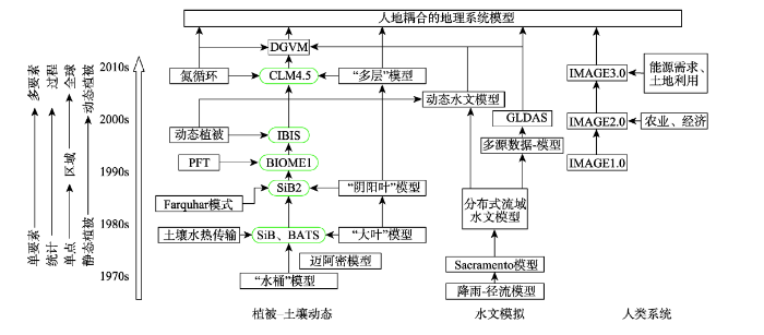