陈宝芬 , 张耀民
, 张耀民
CHEN Baofen, ZHANG Yaomin
通讯作者:
收稿日期: 2016-09-20
网络出版日期: 2017-05-20
版权声明: 2017 地理科学进展 《地理科学进展》杂志 版权所有
基金资助:
作者简介:
作者简介:陈宝芬(1990-),女,河北唐山人,硕士研究生,主要从事资源环境遥感应用以及城市扩张研究,E-mail:1244910426@qq.com。
展开
摘要
以中国海西地区重要门户福州市为研究区,结合其地理位置多层次约束性条件,以地理加权回归模型作为元胞自动机(CA)层的转换规则,同时以2000-2015年多期LandsatTM/ETM+影像的城市用地情况为参照,借助GIS空间分析技术,对CA和多智能体(ABM)相耦合的城市用地扩张模型进行改进。然后利用传统的和改进后的CA-ABM模型,多角度、多层次地模拟福州市2000年、2005年、2010年、2015年城市用地扩张在微观格局上的变化。结果表明,传统的和改进后的CA-ABM模型的整体精度均在80%以上,模拟结果具有较强的可信度;改进的 CA-ABM模型模拟的点对点总体精度和Kappa系数均高于传统的CA-ABM模型,而且模拟结果更加接近实际的城市用地扩张分布情况。结论可为平衡城市化进程和合理规划城市用地提供重要的理论技术支撑。
关键词:
Abstract
Fuzhou City is an important gateway west of the South China Sea. This study uses geographically weighted regression (GWR) as the transformation rules of cellular automata (CA) layer based on the multi-level constraint conditions, taking into account geographical location, natural factors, and the multi-criteria and willingness of various agents to make decisions on environmental change, to simulate urban land expansion of Fuzhou City from 2000 to 2015. Using the urban land use data derived from remote sensing imageries of Fuzhou City in 2000-2015 as a reference, and with the help of GIS spatial analysis technology, this study developed an improved model of urban land expansion based on coupled CA and ABM. The traditional and improved CA-ABM models were used to simulate urban land expansion and change with a microscopic view for Fuzhou City in 2000, 2005, 2010, and 2015 from multiple angles and at multiple levels. The results show that the overall accuracy of the traditional and improved CA-ABM models was higher than 80%, and the simulation results based on the CA-ABM models for Fuzhou City are reliable. The point-to-point overall accuracy and Kappa of the improved CA-ABM model were higher than the traditional CA-ABM model, and the results of the improved CA-ABM model were closer to the actual distribution of urban land expansion in Fuzhou. It indicates that the improved CA-ABM model can be used to simulate urban land expansion, more accurately expresses a variety of geographic processes and mechanisms, and improves the reliability and stability of the simulation results. Finally, a forecast of the distribution of urban land expansion in 2020 and 2030 based on the improved CA-ABM model with scenario natural, economic, and social developments in Fuzhou provides an important theoretical and technical support for the urban land use planning of the city.
Keywords:
城市土地是人类活动最频繁的区域,其空间扩展已成为衡量城市化水平的重要测度指标(李新东等, 2016)。城市扩张是城市由于社会生产力的发展而引起的城市空间增长、城市规模扩大,也是农村人口向城市集中的过程。作为经济发展的客观要求和必然产物,它已成为继工业化、现代化、信息化之后的又一全球性趋势(徐新良等, 2014)。《中国城市状况报告2010-2011》指出,今后5年内,中国的城镇人口将超过农村人口,到2030年,中国城镇化率将达到65%左右,各类城镇将新增3亿多人口(汪光焘, 2014)。诺贝尔经济学奖获得者Stiglitz则把“中国的城市化”和“美国的高科技”并称为 21 世纪人类发展进程的两大关键因素(牛文元, 2009)。因此,城市扩张的过程、机理等已成为地理学、测绘学、经济学、生态学等学科的研究热点,目的是为城市用地非理性扩张造成的生态破坏、环境污染等严重阻碍城市可持续发展问题的治理提供理论和技术支撑(Angela et al, 2011; Wei et al, 2014; Liu et al, 2016)。
纵观当前国内外的研究工作,城市扩张模拟研究可以分为两大类:一类是基于多期遥感数据的分析模拟,另一类是基于城市系统模型的参数优化模拟。前者是在多期遥感数据的城市用地现状分析基础上,对其趋势进行统计分析与预测;后者则是在分析城市用地扩张机理的基础上,动态地模拟预测其发展趋势与变化。近年,随着科学技术的不断发展,特别是人工智能理论的不断进步,越来越多的学者将元胞自动机模型(CA)和多智能模型(Agent-based Model, ABM)作为模拟城市用地扩张的主要手段。例如Wahyudi等(2015)在CA-ABM的基础上结合空间动力学对城市扩张的研究;Rienow等(2014)通过CA-ABM的结合预测了德国鲁尔区2025年的城市结构;Basse等(2014)、肖琳等(2014)、张鸿辉等(2011a, 2011b, 2011c)及杨青生等(2007a, 2007b)的研究提供了利用CA和ABM进行土地利用格局演变模型的应用案例,研究区尺度包括城区、县域或城市群。
目前,基于CA-ABM模型对城市用地扩张模拟研究,各领域学者已经做了大量工作,并且展示出较好的优势和前景,但尚存在以下突出问题:在CA与ABM耦合的过程中,CA层的转换规则依然局限于自身邻域状态的组合,难以反映地理区位、社会经济条件等因素对城市用地格局的影响(廖江福等, 2014),ABM层中更多的只是单纯模拟智能体的决策行为,忽视其选择意愿,从而影响模型的整体精度。而本文在前人研究的基础上,尝试解决上述不足,具体途径为:首先,从微观机制出发充分考虑地理区位、自然因素,借助GIS空间分析技术,以地理加权回归模型(Geographically Weighted Regression, GWR)作为CA层转换规则,真实地模拟自然、社会、经济等因素作用下城市用地在微观格局上的变化;其次,在ABM层加上地理区位与微观智能体的耦合关系以及各个智能体对环境变化决策的多准则性和选择意愿,结合多期遥感影像的城市用地情况,对城市用地进行多角度、多层次的模拟研究。结果表明,本文较好地解决了传统CA因转换阈值的不确定性而导致模拟精度低的问题,同时改进了ABM中智能体决策逻辑推理的复杂性和意愿性,使CA-ABM模型的模拟结果更加真实、可靠,可以更好地为城市的可持续发展和规划提供科学依据。
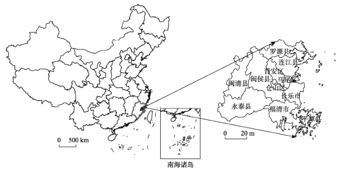
选择福建省福州市作为研究区。福州位于福建东部、闽江下游沿岸,台湾海峡以西。西靠三明市、南平市,南邻莆田市、泉州市,北接宁德市。市域范围包括:台江、仓山、晋安、鼓楼及马尾5个区,及福清、长乐2个县级市,闽侯、连江、罗源、闽清、永泰、平潭6个县的50个乡镇。具体位置如图1。
福州作为中国海西地区辐射中西部的重要门户,既是连接东北亚与东南亚的海上中点,同时也是进入福建内陆的咽喉。近年来福州市的社会经济和城市建设取得快速发展,其城市用地在人类活动的干预下也发生巨大变化。
本文选取2000年6月、2005年11月、2010年11月TM和2015年8月ETM+的4期卫星影像作为数据源,图像质量均良好。借助大比例地形图对所获取的遥感数据进行图像波段配准、大气校正、几何校正等预处理后,裁剪出本文所需要的研究区范围,然后利用计算机自动分类与人工交互相结合的方法提取城市用地信息,通过实地考察和抽样调查对分类结果进行验证,提取精度保证在80%以上,并将其最终统一到albers投影下。将这4期福州市城市用地分布图代替2000年、2005年、2010年和2015年城市用地实际扩张情况作为验证数据,调整模型参数。
在阅读相关文献的基础上,本文选取的数据主要包括:数字高程(DEM)和坡度(Slope)数据、数字城市专题数据(教育资源、医疗卫生资源、休闲设施等分布数据)、交通道路数据、河流数据、生活品市场数据、灯光数据、地价和房价数据(在模型设中参考的实际经济收益,为房价与地价之差)等作为模型基础数据。数字高程和坡度数据来自于美国奋进号航天飞机的雷达地形测绘(Shuttle Radar Topography Mission, SRTM);数字城市专题、生活品市场数据为从福州市POI数据中提取出的点分布数据;地价和房价数据从福州市搜房网下载获取;交通道路数据来自OpenStreetMap;夜间灯光数据来自美国国家航空航天局地球观测站(NASA's Earth Observatory)。
本文需对上述数据作如下预处理:首先进行投影转换,统一获得albers投影;然后借助于GIS空间分析功能对数据进行欧氏距离计算分析,并统一重采样成100 m×100 m栅格;最后,消除所有数据量纲对模型研究的影响,利用ArcGIS中的栅格计算工具Raster Calculator完成标准化过程。本文采用模糊隶属度函数模型对各种数据进行标准化(张云堂, 2014)。正向因子的模糊隶属度函数模型为:
负向因子的模糊隶属度函数模型为:
式中:
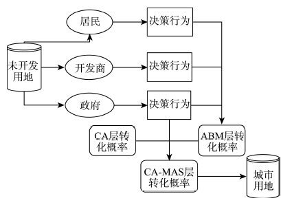
针对CA层的转换规则局限于自身邻域状态的组合上,以及ABM层单纯模拟智能体的决策行为而忽视其选择意愿等问题,本文以地理加权回归为CA层转换规则,从微观角度出发综合考虑地理区位、自然因素以及各智能体对环境变化决策的意愿性和逻辑性,对模型进行改进,使其更为准确地表达各种地理过程和机理,提高模拟结果在地理位置上的可信度和稳定性。因此,本文设计的城市用地扩张模型由以下两大部分组成:元胞自动机模型和多智能体模型(图2)。其中,元胞自动机模型是以各空间数据信息为基础的环境层,采用地理加权回归方法作为转换规则;而多智能体模型选取利用主体、开发主体以及政府主体作为微观智能体,研究讨论其对未开发地块的决策效用,构建ABM层的城市用地转化概率。2个模型最终通过共同的栅格空间实现交互,在汪锐良等(2013)研究方法的基础上加以改进,最终获得未开发地块的CA-ABM的转化概率。即可表示为:
式中:
图2 基于CA与ABM的城市居住用地扩张模型
Fig.2 Urban residential land expansion based on coupled cellular automata and agent-based model (CA-ABM)
环境层由 GIS 获取的一系列环境要素层构成,包括交通通达层、社会状况层、经济发展层、自然条件层及城市用地层(表1)本文采用指数距离衰减函数(Tian et al, 2014)表达某环境要素层对某位置的吸引力,以交通通达层为例,其公式为:
式中:
表1 环境层类型及数据
Tab.1 Environmental layers and data
| 环境层类型 | 数据 |
|---|---|
| 交通通达层 | 到高速公路、一般公路的距离 |
| 社会状况层 | 到教育资源、医疗卫生资源、休闲服务距离 |
| 经济发展层 | 地价、房价、到生活品市场的距离 |
| 自然条件层 | 高程、坡度 |
| 城市用地层 | 2000、2005、2010、2015年城市用地数据 |
本文采用地理加权回归(Geographically Weighted Regression, GWR)作为元胞自动机的转换函数,综合考虑地理区位、自然、社会、经济等因素,以提高模型的模拟能力。
地理加权回归将局部地理位置的空间特性纳入模型中,反映空间上某一点的特征值受其邻近观测点特征值的影响程度,并且这种影响会随距离的增加逐渐降低(翟瑞雪, 2015; 李欣, 2016)。地理加权回归对一般的全局最小二乘回归模型进行扩展,将数据的地理位置嵌入到回归参数之中,其表达式为:
式中:
因此,非城市用地的土地单元向城市用地转化的CA层概率又可以表示为:
式中,
本文根据主体的功能、属性以及城市用地需求,将主体分为3类:利用主体(城市居民)、开发主体(房地产开发商)和政府主体。
(1) 利用主体的空间决策模型
利用主体是城市用地的终端消费者,在土地效用最大化原则的假设前提下,结合前人的研究成果(张云堂, 2014; Tsai et al, 2015),采用随机效用模型,综合考虑利用主体在城市用地选择决策过程中的行为和意愿,得到某一待选土地单元(i, j)对利用主体Agent的选择偏好概率,可表示为交通便利度、医疗条件、教育条件、环境质量、经济状况、土地利用状况以及区位条件的函数。
(2) 开发主体的空间决策模型
在前人研究的基础上(张云堂, 2014),利用随机效用模型和离散选择模型,同时综合考虑开发主体和利用主体双方是相互影响、交互决策以及选择偏好问题,得到开发主体的选择效用公式:
式中:
(3) 政府主体的空间决策模型
政府在城市用地扩张的过程中扮演着引导者的角色,本文研究获取非城市用地单元转化为城市用地的转化概率,借鉴刘小平、黎夏等(刘小平等, 2006)的土地适宜性评价方法,综合考虑自然地理、法规政策等因素,其中自然条件主要包括高程、坡度和土地类型。
城市用地发展的空间自组织性以及城市用地扩张过程中各微观主体决策行为的相互影响,共同推动了城市用地的扩张。因此,基于CA与ABM的城市用地扩张模型的转化概率可表示为:
式中:
本文以2000年数据为基准,利用传统的CA-ABM模型(张云堂,2014)与改进后的CA-ABM模型对2000年福州市城市用地情况进行模拟,确定模型参数,然后再利用模型分别对2005年、2010年和2015年福州市城市用地扩张情况进行模拟,并通过与2005年、2010年和2015年城市用地实际扩张情况进行对比,调整参数优化模型,最后得到模拟结果(图3)。
图3 2000、2005、2010、2015年福州市城市用地扩张模拟结果与实际结果对比图
Fig.3 Urban land expansion simulation results compared with the actual urban land expansion of Fuzhou city, 2000, 2005, 2010, and 2015
结合图3,从整体上看,改进后的CA-ABM模型获得的结果与传统的CA-ABM模型结果相比,在整体形态上比较一致,但在局部地区略有差别。例如,在福州市的西南部和东北部,传统模型误将部分农村居民点归为城市用地范围。
为了对改进前后的模型效果进行细致分析,本文采用点对点验证和Kappa系数两种方式对模拟结果进行精度评价。点对点验证是将模拟结果与实际情况进行叠加,然后逐点比较计算精度;而Kappa系数检验是评价空间模拟精度的一种常用指数,不同的Kappa系数表明相应的空间模拟一致性。Kappa的计算结果越接近于1,表明模拟结果与实际情况越接近。2000年、2005年、2010年和2015年模拟验证结果如表2所示。
表2 基于CA-ABM模型的城市用地扩张模拟结果检验表
Tab.2 Urban land expansion test results based on the traditional and modified CA-ABM models
| 传统CA-ABM模型 | 改进CA-ABM模型 | |||
|---|---|---|---|---|
| Kappa/% | 总精度/% | Kappa/% | 总精度/% | |
| 2000年 | 85.12 | 91.67 | 98.65 | 96.26 |
| 2005年 | 84.03 | 91.62 | 93.44 | 96.84 |
| 2010年 | 87.68 | 89.79 | 95.87 | 97.19 |
| 2015年 | 85.61 | 87.53 | 92.03 | 97.93 |
由表2可知,表2用量化的形式显示模型精度验证结果,其中传统的CA-ABM模型模拟的2000年、2005年、2010年和2015年点对点总体精度分别为91.67%、91.62%、89.79%和87.53%,Kappa系数分别为85.12%、84.03%、87.68%和85.61%;改进后的CA-ABM模型模拟的2000年、2005年、2010年和2015年点对点总体精度分别为96.26% 、96.84%、97.19%和97.93%,Kappa系数分别为98.65%、93.03%、95.87%和92.03%。两种模型的精度均在80%以上,表明其在模拟福州市城市用地扩张的模拟结果有较强的可信度,而且修改后的模型精度更高,更稳定。
随着福州市城市用地扩张进程的不断加快,城市用地开始向周边河流和主要交通干线大规模扩张,加上港口吞吐量以及进出口贸易量的快速增长,促使福清区和平潭县的城市用地快速扩张。尤其是2015年,在“一带一路”战略和福州新区等政策的促进下,城市用地在2010年的基础上呈现大规模扩张趋势,以西南部最为明显。改进后的模型从微观角度出发,综合考虑人为和自然环境等各种因素,使模型的总体精度和Kappa系统均有所提高,这表明改进后的模型是可行的,而且更加可靠、稳定。
情景是指对一些存在合理或不确定性的事件在未来一段时间内可能呈现的态势的一种假定(王贞超, 2012)。本文根据福州市城市用地扩张的条件和特点,以及未来经济社会发展对城市用地的需求规划,模拟福州市2020年和2030年城市用地的扩张情况(图4)。由图4可知,随着福州市城市用地扩张进程的加快,相对集中的核心城市用地区的空间已不能满足城市用地的发展要求,因此其城市用地开始沿河流和主要交通干线大规模扩张,居民点集聚成城市用地明显。城市用地量从3735 km2增加到4421 km2,年平均水平达到1.84%,相比于2000-2015年增速略有减缓。在原有城市用地连接成片的基础上,城市用地主要往两个方向扩张,一个是东北部,另一个是西南部,空间格局变化明显。模拟结果可为编制土地利用规划和城市的可持续发展提供科学依据。
图4 福州市城市用地扩张模型预测结果图
Fig.4 Urban land expansion prediction results of Fuzhou City
本文在研究福州市2000-2015年城市用扩张的基础上,以元胞自动机(CA)和多智能体(ABM)的相关理论为支撑,结合地理位置多层次约束性条件,以地理加权回归模型作为CA层转换规则,从微观角度出发充分考虑地理区位、自然因素以及各智能体对环境变化决策的多准则性和意愿性,并以多期遥感影像的城市用地为参照,借助GIS空间分析技术,对CA和ABM相耦合的城市用地扩张模型进行改进,然后利用传统的和改进后的CA-ABM模型,多角度、多层次地模拟福州市2000年、2005年、2010年、2015年城市用地扩张在微观格局上的变化。最后运用该模型,并结合福州市未来经济社会发展对城市用的需求规划,对2020年和2030年城市用地分布情况进行了预测。主要结论为:
(1) 传统的和改进后的CA-ABM模型整体精度均在80%以上,表明基于CA-ABM模型来模拟福州市城市用地扩张的模拟结果有较强的可信度;而且改进后的模型精度更高,与福州市城市用地扩张的实际情况更为接近,表明改进后的模型更加稳定、可信。最后,利用该模型,结合福州市未来经济社会发展对城市用地扩张的需求规划,对2020年和 2030年福州市城市用地扩张进行了模拟和预测,结果表明城市用地扩张依然保持开速发展趋势,尤其以西南和东北方向最为明显。
(2) 改进后的CA-ABM模型从微观机制出发,充分考虑了地理区位、自然因素、智能体选择意愿以及其间的相互耦合,借助GIS空间分析技术,以地理加权回归模型作为CA层转换规则,对城市用地进行多角度、多层次的模拟研究。相比于传统模型,其较好地解决了模型因转换阈值的不确定性而导致模拟精度低的问题使其模拟结果更加真实、可靠。
尽管本文利用优化后的CA-ABM模型模拟福州市城市用地扩张,结果相对较好,但由于城市用地是受到自然、经济、社会等因素相互影响的复杂系统,要完全模拟其演变过程和细节是具有挑战性的。在今后的研究中还有很多需要改进的地方,例如,为确保模型更加稳定可靠,可将人口、GDP等社会驱动力纳入模型;预测过程中,结合福州市发展规划,可设定不同发展情景,使预测结果更加接近实际情况。
The authors have declared that no competing interests exist.
| [1] |
基于GWR模型的鄱阳湖地区城镇用地空间扩张差异及其影响因素研究 [J].Spatial differences of urban land expansion in Poyang Lake region and its influencing factors based on GWR model [J]. |
| [2] |
基于RS和GIS的北海市城市空间扩展监测分析 [J].https://doi.org/10.3969/j.issn.1672-5867.2016.01.032 URL [本文引用: 1] 摘要
准确判别城市扩展规律、剖析演化过程,对于预测城市未来演化趋势、制定合理的调控政策具有重要的意义。本文以1990年、2000年、2008年和2012年4个具有代表性年份的卫星影像为依据,应用RS和GIS手段提取了北海市城市实体边界,分析了该市扩展空间特征、面积、方向和速度。研究结果表明:22年间北海市城市实体加速扩展,但其建成率基本不变,这种变化反映了城市规划、宏观调控、海岸带利用政策以及交通对城市扩展的影响。
Characteristic monitor and analysis of spatial expansion of Beihai city based on RS and GIS [J].https://doi.org/10.3969/j.issn.1672-5867.2016.01.032 URL [本文引用: 1] 摘要
准确判别城市扩展规律、剖析演化过程,对于预测城市未来演化趋势、制定合理的调控政策具有重要的意义。本文以1990年、2000年、2008年和2012年4个具有代表性年份的卫星影像为依据,应用RS和GIS手段提取了北海市城市实体边界,分析了该市扩展空间特征、面积、方向和速度。研究结果表明:22年间北海市城市实体加速扩展,但其建成率基本不变,这种变化反映了城市规划、宏观调控、海岸带利用政策以及交通对城市扩展的影响。
|
| [3] |
城市元胞自动机扩展邻域效应的测量与校准研究 [J].https://doi.org/10.11820/dlkxjz.2014.12.005 URL Magsci [本文引用: 1] 摘要
城市元胞模型由于在定量分析与预测城市动态的潜力而受到众多研究者的持续关注。邻域规则是主导城市元胞模型模拟过程的关键组件。研究表明,不同土地利用组合间存在显著的邻域效应,且邻域效应具有惯性、排斥和吸引等影响。然而,传统城市元胞模型主要考虑的是特定分辨率下较小窗口的邻域范围。本文尝试刻画更大窗口的邻域效应及其对元胞模型的影响。基于测量的扩展邻域因子,应用粒子群优化算法校准大窗口邻域规则,并创建了考虑扩展邻域效应的城市元胞模型。为验证模型有效性,将其应用于模拟厦门市1995-2010 年期间的城市扩张动态。与3 × 3 摩尔邻域的逻辑回归模型相比较,1995-2010 年期间的建设用地模拟精度从80.7%提高到83.9%,总体精度从87.8%提高到89.6%,Kappa 系数从70.0%提高到74.5%,表明考虑扩展邻域效应的城市模型取得了更好的模拟效果。
Measuring and calibrating extended neighborhood effect of urban cellular automata model based on particle swarm optimization [J].https://doi.org/10.11820/dlkxjz.2014.12.005 URL Magsci [本文引用: 1] 摘要
城市元胞模型由于在定量分析与预测城市动态的潜力而受到众多研究者的持续关注。邻域规则是主导城市元胞模型模拟过程的关键组件。研究表明,不同土地利用组合间存在显著的邻域效应,且邻域效应具有惯性、排斥和吸引等影响。然而,传统城市元胞模型主要考虑的是特定分辨率下较小窗口的邻域范围。本文尝试刻画更大窗口的邻域效应及其对元胞模型的影响。基于测量的扩展邻域因子,应用粒子群优化算法校准大窗口邻域规则,并创建了考虑扩展邻域效应的城市元胞模型。为验证模型有效性,将其应用于模拟厦门市1995-2010 年期间的城市扩张动态。与3 × 3 摩尔邻域的逻辑回归模型相比较,1995-2010 年期间的建设用地模拟精度从80.7%提高到83.9%,总体精度从87.8%提高到89.6%,Kappa 系数从70.0%提高到74.5%,表明考虑扩展邻域效应的城市模型取得了更好的模拟效果。
|
| [4] |
基于多智能体的土地利用模拟与规划模型 [J].
<p>利用多智能体和元胞自动机对城市土地资源的可持续利用进行了规划。根据环境经济学资源分配原理和可持续发展理论,提出结合多智能体及元胞自动机的微观规划模型,在时间和空间上合理分配及规划城市土地资源的利用,以避免浪费不可再生的土地资源。该模型由相互作用的多智能体层、元胞自动机层和环境因素层组成,可方便地探索不同土地利用政策下城市土地利用发展情景,能够为城市规划提供有用的决策依据。以广州市海珠区为实验区,在可持续发展为前提的规划下,模拟了1995-2010年的城市扩展的动态变化,并讨论了在不同规划情景下城市土地资源的利用效率及合理性。</p>
Multi-agent systems for simulating and planning land use development [J].
<p>利用多智能体和元胞自动机对城市土地资源的可持续利用进行了规划。根据环境经济学资源分配原理和可持续发展理论,提出结合多智能体及元胞自动机的微观规划模型,在时间和空间上合理分配及规划城市土地资源的利用,以避免浪费不可再生的土地资源。该模型由相互作用的多智能体层、元胞自动机层和环境因素层组成,可方便地探索不同土地利用政策下城市土地利用发展情景,能够为城市规划提供有用的决策依据。以广州市海珠区为实验区,在可持续发展为前提的规划下,模拟了1995-2010年的城市扩展的动态变化,并讨论了在不同规划情景下城市土地资源的利用效率及合理性。</p>
|
| [5] |
|
| [6] |
|
| [7] |
基于ABM的城市扩张、耕地保护与湿地流失的模拟研究: 以杭州市萧山区为例[D] .Research on simulation of urban expansion, cultivated land protection and wetland loss based on Agent-based model: A study of Xiaoshan[D]. |
| [8] |
基于GIS和MAS的城市用地扩展模拟研究[D] .Study of simulation for urban land expansion based on GIS and MAS[D]. |
| [9] |
基于Agent的城市扩张占用耕地动态模型及模拟 [J].
An agent-based approach for urban encroachment on cropland dynamic model and simulation [J].
|
| [10] |
城市扩展研究的主要进展与展望 [J].
城市扩展是现阶段多个学科的研究热点, 国内外学者对它的时空特征、驱动机制、模拟和预测方法以及环境效益等问题做了大量研究和探索。文章对城市扩展的研究体系、研究方法和尺度问题进行了总结和分析, 并对未来城市扩展的研究方向进行了展望。研究发现: (1)目前城市扩展的研究已经形成多学科的交叉研究局面, 各学科为城市扩展的研究提供了丰富的方法支撑, 但理论探索相对缺乏; (2)目前元胞自动机和分形理论在城市扩展的研究中应用较多, 引入其他有效的数理方法深化城市扩展研究非常必要; (3)尺度在城市扩展研究中非常重要, 慎重选择时空粒度能更好的反映和揭示城市扩展的特征和规律; (4)我国对城市扩展的研究在理论上和方法上借鉴国外的居多, 结合中国城市化实际进行理论探索, 并深入对全国范围城市扩展特征和规律的全面认识, 是中国未来城市扩展研究的重要方向。<br>
Main progress and prospect of urban expansion study [J].
城市扩展是现阶段多个学科的研究热点, 国内外学者对它的时空特征、驱动机制、模拟和预测方法以及环境效益等问题做了大量研究和探索。文章对城市扩展的研究体系、研究方法和尺度问题进行了总结和分析, 并对未来城市扩展的研究方向进行了展望。研究发现: (1)目前城市扩展的研究已经形成多学科的交叉研究局面, 各学科为城市扩展的研究提供了丰富的方法支撑, 但理论探索相对缺乏; (2)目前元胞自动机和分形理论在城市扩展的研究中应用较多, 引入其他有效的数理方法深化城市扩展研究非常必要; (3)尺度在城市扩展研究中非常重要, 慎重选择时空粒度能更好的反映和揭示城市扩展的特征和规律; (4)我国对城市扩展的研究在理论上和方法上借鉴国外的居多, 结合中国城市化实际进行理论探索, 并深入对全国范围城市扩展特征和规律的全面认识, 是中国未来城市扩展研究的重要方向。<br>
|
| [11] |
多智能体与元胞自动机结合及城市用地扩张模拟 [J].https://doi.org/10.3969/j.issn.1000-0690.2007.04.015 URL Magsci 摘要
运用多智能体(Agent)和元胞自动机(CA)结合来模拟城市用地扩张的方法,将影响和决定用地类型转变的主体作为Agent引进元胞自动机模型中,Agent在CA确定的城市发展概率的基础上,通过自身及其周围环境的状况,综合各种因素的影响做出决策,决定元胞下一时刻的城市发展概率。运用Agent的决策结果,对CA模型中以随机变量体现的不确定性通过Agent决策行为给予地理意义的新解释。以城市郊区—樟木头镇为例,对1988~1993年城市用地扩张进行了模拟研究,取得了良好的模拟效果。
Integration of multi-agent systems with cellular automata for simulating urban land expansion [J].https://doi.org/10.3969/j.issn.1000-0690.2007.04.015 URL Magsci 摘要
运用多智能体(Agent)和元胞自动机(CA)结合来模拟城市用地扩张的方法,将影响和决定用地类型转变的主体作为Agent引进元胞自动机模型中,Agent在CA确定的城市发展概率的基础上,通过自身及其周围环境的状况,综合各种因素的影响做出决策,决定元胞下一时刻的城市发展概率。运用Agent的决策结果,对CA模型中以随机变量体现的不确定性通过Agent决策行为给予地理意义的新解释。以城市郊区—樟木头镇为例,对1988~1993年城市用地扩张进行了模拟研究,取得了良好的模拟效果。
|
| [12] |
基于遗传算法自动获取CA 模型的参数: 以东莞市城市发展模拟为例 [J].https://doi.org/10.3321/j.issn:1000-0585.2007.02.003 URL Magsci 摘要
本文提出了基于遗传算法来寻找CA模型最佳参数的方法。CA被越来越多地应用于城市和土地利用等复杂系统的动态模拟。CA模型中变量的参数值对模拟结果有非常重要的影响。如何获取理想的参数值是模型的关键。传统的逻辑回归模型运算简单,常常用来获取模型的参数值,要求解释变量间线性无关,所以获取的城市CA模型参数具有一定的局限性。遗传算法在参数优化组合、快速搜索参数值方面有很大的优势。本文利用遗传算法来自动获取优化的CA模型参数值,并获得了纠正后的CA模型。将该模型应用于东莞1988~2004年的城市发展的模拟中,得到了较好的效果。研究结果表明,遗传算法可以有效地自动获取CA模型的参数,其模拟的结果要比传统的逻辑回归校正的CA模型模拟精度高。
Calibrating urban cellular automata using genetic algorithms [J].https://doi.org/10.3321/j.issn:1000-0585.2007.02.003 URL Magsci 摘要
本文提出了基于遗传算法来寻找CA模型最佳参数的方法。CA被越来越多地应用于城市和土地利用等复杂系统的动态模拟。CA模型中变量的参数值对模拟结果有非常重要的影响。如何获取理想的参数值是模型的关键。传统的逻辑回归模型运算简单,常常用来获取模型的参数值,要求解释变量间线性无关,所以获取的城市CA模型参数具有一定的局限性。遗传算法在参数优化组合、快速搜索参数值方面有很大的优势。本文利用遗传算法来自动获取优化的CA模型参数值,并获得了纠正后的CA模型。将该模型应用于东莞1988~2004年的城市发展的模拟中,得到了较好的效果。研究结果表明,遗传算法可以有效地自动获取CA模型的参数,其模拟的结果要比传统的逻辑回归校正的CA模型模拟精度高。
|
| [13] |
基于多主体模型的城市扩张模拟研究: 以赣州市章贡区为例[D] .Research on simulation of urban expansion based on multi-agent model: A case study in Zhanggong District, Ganzhou City[D]. |
| [14] |
多目标土地利用空间优化配置模型及其应用 [J].URL 摘要
为探索一种客观、量化且能解决多目标决策问题的土地利用空间优化配置方法,在"资源节约"与"环境友好"目标约束下,设计应用于土地利用空间优化配置的多智能体遗传进化算法,构建多目标土地利用空间优化配置MOSOLUA(Multi objective spatial optimization model for land use allocation)模型;以国家资源节约型和环境友好型社会建设综合配套改革实验区——长株潭城市群的核心区域为例,进行多目标土地利用空间优化配置应用研究。研究结果表明:基于MOSOLUA模型得到的优化后的土地利用格局的资源节约与环境友好程度较优化前有明显提高;MOSOLUA模型的收敛速度较普通遗传算法模型的快,实证应用所花时间由8.57 h减少到3.31 h,运行效率提高61.38%;模型的总体适应度与采用普通遗传算法的优化配置模型相比提高了12.57%。
Multi-objective spatial optimization model for land use allocation and its application [J].URL 摘要
为探索一种客观、量化且能解决多目标决策问题的土地利用空间优化配置方法,在"资源节约"与"环境友好"目标约束下,设计应用于土地利用空间优化配置的多智能体遗传进化算法,构建多目标土地利用空间优化配置MOSOLUA(Multi objective spatial optimization model for land use allocation)模型;以国家资源节约型和环境友好型社会建设综合配套改革实验区——长株潭城市群的核心区域为例,进行多目标土地利用空间优化配置应用研究。研究结果表明:基于MOSOLUA模型得到的优化后的土地利用格局的资源节约与环境友好程度较优化前有明显提高;MOSOLUA模型的收敛速度较普通遗传算法模型的快,实证应用所花时间由8.57 h减少到3.31 h,运行效率提高61.38%;模型的总体适应度与采用普通遗传算法的优化配置模型相比提高了12.57%。
|
| [15] |
基于多智能体的农地非农化时空模拟与规划模型 [J].
已有的土地利用/土地覆盖变化(LUCC)模型或者城市增长模拟模型虽然能够模拟与预测农地的空间分布,但是不能解释引起农地非农化的各种行为体之间的相关关系,更不能对农地非农化进行合理的时空模拟与规划。遵循时间与空间规划效率最大化和可持续发展准则,基于多行为体系统和资源经济学理论构建了农地非农化时空模拟与规划模型 (Spatio-temporal simulation and planning of farmland conversion Model (STSPFCM)。该模型由外部环境、多行为体系统、决策框架组成,可实现影响农地非农化过程的行为体决策规则的时间与空间“显性”表达,模拟不同农地非农化规划准则下的农地非农化发展趋势,实现农地非农化的时空规划。以长沙、株洲、湘潭城市群的核心区域—长沙市为实验区,利用STSPFCM对2006-2020年长沙市农地非农化进行了时空模拟与规划。结果表明:STSPFCM能够为农地非农化时空规划提供有意义的辅助决策支持。
A spatio-temporal simulation and planning model for farmland conversion based on multi-agent systems [J].
已有的土地利用/土地覆盖变化(LUCC)模型或者城市增长模拟模型虽然能够模拟与预测农地的空间分布,但是不能解释引起农地非农化的各种行为体之间的相关关系,更不能对农地非农化进行合理的时空模拟与规划。遵循时间与空间规划效率最大化和可持续发展准则,基于多行为体系统和资源经济学理论构建了农地非农化时空模拟与规划模型 (Spatio-temporal simulation and planning of farmland conversion Model (STSPFCM)。该模型由外部环境、多行为体系统、决策框架组成,可实现影响农地非农化过程的行为体决策规则的时间与空间“显性”表达,模拟不同农地非农化规划准则下的农地非农化发展趋势,实现农地非农化的时空规划。以长沙、株洲、湘潭城市群的核心区域—长沙市为实验区,利用STSPFCM对2006-2020年长沙市农地非农化进行了时空模拟与规划。结果表明:STSPFCM能够为农地非农化时空规划提供有意义的辅助决策支持。
|
| [16] |
多智能体区域土地利用优化配置模型及其应用 [J].https://doi.org/10.11821/xb201107010 URL Magsci 摘要
土地利用优化配置对促进区域可持续土地利用具有重要意义,然而现有的土地利用优化配置模型引导可持续土地利用的能力有待提高。本文从整体考量区域土地利用优化配置数量、空间、时间三维特征的角度,定义了区域土地利用优化配置多智能体系统及其决策行为规则,构建了基于多智能体系统的区域土地利用优化配置RLUOA (Regional Land Use OptimizationAllocation) 模型,并以中部地区典型城市——长沙市为例开展了实证应用研究。研究结果表明:该模型能够将规划时间段内多目标约束的区域土地利用规模的数量结构合理配置到不同的空间单元,实现土地利用数量结构、空间布局、效益的协同优化,构建整体上经济可行、社会可接受、生态环境友好的土地利用格局,并明显提高区域整体土地利用经济、生态和社会效益,从而能够为促进区域土地资源可持续利用和制定土地利用总体规划提供参考借鉴。
A model for regional land use optimization allocation based on multi-agent system and its application [J].https://doi.org/10.11821/xb201107010 URL Magsci 摘要
土地利用优化配置对促进区域可持续土地利用具有重要意义,然而现有的土地利用优化配置模型引导可持续土地利用的能力有待提高。本文从整体考量区域土地利用优化配置数量、空间、时间三维特征的角度,定义了区域土地利用优化配置多智能体系统及其决策行为规则,构建了基于多智能体系统的区域土地利用优化配置RLUOA (Regional Land Use OptimizationAllocation) 模型,并以中部地区典型城市——长沙市为例开展了实证应用研究。研究结果表明:该模型能够将规划时间段内多目标约束的区域土地利用规模的数量结构合理配置到不同的空间单元,实现土地利用数量结构、空间布局、效益的协同优化,构建整体上经济可行、社会可接受、生态环境友好的土地利用格局,并明显提高区域整体土地利用经济、生态和社会效益,从而能够为促进区域土地资源可持续利用和制定土地利用总体规划提供参考借鉴。
|
| [17] |
基于CA与ABM的城市居住用地扩张微观驱动机理模拟: 以杭州市为例[D] .Research on simulation of urban residential land expansion's microscopic drive mechanism based on CA and Agent-based model: A case study of Hangzhou[D]. |
| [18] |
The dimensions of global urban expansion: Estimates and projections for all countries, 2000-2050 [J].https://doi.org/10.1016/j.progress.2011.04.001 URL [本文引用: 1] 摘要
Our study of the expansion of a representative sample of 30 cities showed that 28 of them expanded more than 16-fold during the twentieth century. More generally, cities are now expanding at twice their population growth rates, on average, and now cover almost 0.5% of the planet's land area. We created a new dataset comprising the universe of all 3646 named metropolitan agglomerations and cities that had populations in excess of 100,000 in the year 2000, their populations in that year, and their built-up area identified in the Mod500 map, currently the best of eight satellite-based global maps of urban land cover. Using this dataset, we estimated urban land cover in smaller cities and towns in all countries and calculated total urban land cover in every country in the year 2000. We then employed multiple regression models that could explain more than 90% of the variations in our urban land cover estimates amongst countries. Then, using U.N. urban population projections in combination with three realistic density change scenarios based on our previous global and historical study of densities, we projected urban land cover in every country and world region from 2000 to 2050. According to our medium projection, urban land cover in developing countries will increase from 300,00002km 2 in 2000 to 770,00002km 2 in 2030 and to 1,200,00002km 2 in 2050. Containing this expansion is likely to fail. Minimal preparations for accommodating it – realistic projection of urban land needs, the extension of metropolitan boundaries, acquiring the rights-of-way for an arterial road grid that can carry infrastructure and public transport, and the selective protection of open space from incursion by formal and informal land development – are now in order.
|
| [19] |
Land use changes modelling using advanced methods: Cellular automata and artificial neural networks. The spatial and explicit representation of land cover dynamics at the cross-border region scale [J].
|
| [20] |
Modeling different urban growth patterns based on the evolution of urban form: A case study from Huangpi, Central China [J].https://doi.org/10.1016/j.apgeog.2015.11.012 URL [本文引用: 1] 摘要
Spatial patterns of urban expansion mainly include infilling, edge expansion, and outlying growth patterns. The cellular automata (CA) model, is an important spatio-temporal dynamic model and effectively simulates infilling and edge-expansion urban expansion. but is evidently lacking in outlying scenarios. In addition, CA cannot explain the causes and processes of urban land expansion. Given these limitations, we proposed a novel urban expansion model called simulation model of different urban growth pattern (SMDUGP), which can work well in both adjacent (i.e., infilling and edge expansion) and outlying growth patterns. SMDUGP has two main components. First, we divided the non-urban region into two categories, namely, candidate region for adjacent pattern urban growth (CRFAP) and candidate region for outlying pattern urban growth (CRFOP). Second, different methods were utilized to simulate urban expansion in the different categories. In CRFAP, a CA model based on the potential of urban growth was proposed to simulate urban growth in relatively randomly selected urban growth regions based on the discrete selection model and Monte Carlo method as the expansion area was implemented in CRFOP. Huangpi, a suburban area in Wuhan, is utilized as the case study area to simulate the spatial and temporal dynamics of urban growth from 2004 to 2024. SMDUGP can effectively simulate outlying urban growth with a highly improved simulation precision compared with the traditional CA model and can explain the causes and processes of urban land expansion.
|
| [21] |
Geosimulation of urban growth and demographic decline in the Ruhr: A case study for 2025 using the artificial intelligence of cells and agents [J].https://doi.org/10.1007/s10109-014-0196-9 URL Magsci 摘要
The Ruhr is an "old acquaintance" in the discourse of urban decline in old industrialized cities. The agglomeration has to struggle with archetypical problems of former monofunctional manufacturing cities. Surprisingly, the image of a shrinking city has to be refuted if you shift the focus from socioeconomic wealth to its morphological extension. Thus, it is the objective of this study to meet the challenge of modeling urban sprawl and demographic decline by combining two artificial intelligent solutions: The popular urban cellular automaton SLEUTH simulates urban growth using four simple but effective growth rules. In order to improve its performance, SLEUTH has been modified among others by combining it with a robust probability map based on support vector machines. Additionally, a complex multi-agent system is developed to simulate residential mobility in a shrinking city agglomeration: residential mobility and the housing market of shrinking city systems focuses on the dynamic of interregional housing markets implying the development of potential dwelling areas. The multi-agent system comprises the simulation of population patterns, housing prices, and housing demand in shrinking city agglomerations. Both models are calibrated and validated regarding their localization and quantification performance. Subsequently, the urban landscape configuration and composition of the Ruhr 2025 are simulated. A simple spatial join is used to combine the results serving as valuable inputs for future regional planning in the context of multifarious demographic change and preceding urban growth.
|
| [22] |
Modeling urban expansion policy scenarios using an agent-based approach for Guangzhou Metropolitan Region of China [J].https://doi.org/10.5751/ES-06909-190352 URL [本文引用: 1] 摘要
Policy makers and the human decision processes of urban planning have an impact on urban expansion. The behaviors and decision modes of regional authority, real estate developer, resident, and farmer agents and their interactions can be simulated by the analytical hierarchy process (AHP) method. The driving factors are regressed with urban dynamics instead of static land-use types. Agents鈥 behaviors and decision modes have an impact on the urban dynamic pattern by adjusting parameter weights. We integrate an agent-based model) (ABM) with AHP to investigate a complex decision-making process and future urban dynamic processes. Three policy scenarios for baseline development, rapid development, and green land protection have been applied to predict the future development patterns of the Guangzhou metropolitan region. A future policy scenario analysis can help policy makers to understand the possible results. These individuals can adjust their policies and decisions according to their different objectives.
|
| [23] |
An interactive land use transition agent-based model (ILUTABM): Endogenizing human-environment interactions in the Western Missisquoi Watershed [J].https://doi.org/10.1016/j.landusepol.2015.07.008 URL [本文引用: 1] 摘要
Forest Transition Theory (FTT) suggests that reforestation may follow deforestation as a result of and interplay between changing social, economic and ecological conditions. We develop a simplistic but empirically data driven land use transition agent-based modeling platform, interactive land use transition agent-based model (ILUTABM), that is able to reproduce the observed land use patterns and link the forest transition to parcel-level heuristic-based land use decisions and ecosystem service (ES). The ILUTABM endogenously links landowners’ land use decisions with ecosystem services (ES) provided by the lands by treating both lands and landowners as interacting agents. The ILUTABM simulates both the land use changes resulting from farmers’ decision behaviors as well as the recursive effects of changing land uses on farmers’ decision behaviors. The ILUTABM is calibrated and validated at 3002m02×023002m spatial resolution using National Land Cover Data (NLCD) 1992, 2001 and 2006 across the western Missisquoi watershed, which is located in the north-eastern US with an estimated area of 283 square kilometers and 312 farmers farming on 16% of the total Missisquoi watershed area. This study hypothesizes that farmers’ land use decisions are made primarily based on their summed expected utilities and that impacts of exogenous socio-economic factors, such as natural disasters, public policies and institutional/social reforms, on farmers’ expected utilities can significantly influence the land use transitions between agricultural and forested lands. Monte Carlo experiments under six various socio-economic conditions combined with different ES valuation schemes are used to assess the sensitivities of the ILUTABM. Goodness-of-fit measures confirm that the ILUTABM is able to reproduce 62% of the observed land use transitions. However, the spatial patterns of the observed land used transitions are more clustered than the simulated counterparts. We find that, when farmers value food provisioning Ecosystem Services (ES) more than other ES (e.g., soil and water regulation), deforestation is observed. However, when farmers value less food provisioning than other ES or they value food provisioning and other ES equally, the forest transition is observed. The ILUTABM advances the Forest Transition Theory (FTT) framework by endogenizing the interactions of socio-ecological feedbacks and socio-economic factors in a generalizable model that can be calibrated with empirical data.
|
| [24] |
Spatial dynamic models for inclusive cities: A brief concept of cellular automata (CA) and agent-based model (ABM) [J].https://doi.org/10.5614/jpwk.2015.26.1.6 URL 摘要
Abstrak.Kawasan perkotaan terutama di negara-negara berkembang menunjukkan laju pertumbuhan fisik yang tinggi. Telah banyak model yang mencoba merekonstruksi pertumbuhan perkotaan ini dengan menggunakan data demografi dan data sosial. Permodelan ini adalah salah satu yang lazim digunakan para praktisi perencana karena ketersediaan data dan waktu proses yang relatif lebih singkat. Sayangnya, model ini bersifat statis yaitu hanya menangkap karakteristik dan bentuk kota pada satu satuan waktu. Model ini tidak akan berubah saat variabel waktu berubah. Kebanyakan model ini bertujuan untuk memperkuat atau memperjelas suatu teori perencanaan perkotaan. Model statis ini juga memanfaatkan batas-batas administrasi dan tidak memungkinkan untuk melakukan permodelan diluar bentuk administrasi sebuah kota. Dengan permasalahan perkotaan yang semakin rumit yang menuntut pengambil keputusan membuat kebijakan tepat, diperlukan suatu metode permodelan pertumbuhan perkotaan yang dinamis yang dapat memberikan informasi yang lebih lengkap kepada pengambil kebijakan terkait struktur dan bentuk perkotaan, serta beroperasi pada skala yang lebih detail. Kemudian model perkotaan ini juga perlu mewakili perilaku para aktor pembangunan perkotaan. Salah satu konsep yang berkembang sejak tiga dasawarsa lalu adalah cellular automata (CA) dan agent-based urban model (ABM). Dalam konteks penelitian perkotaan di Indonesia, sayangnya konsep-konsep ini belum banyak tersedia pada jurnal-jurnal perkotaan dan terlebih lagi belum banyak kontribusi pada konsep-konsep permodelan dan mekanisme pada proses perubahan guna/tutupan lahan. Artikel ini bertujuan untuk memperkenalkan teori dasar CA dan adaptasi dari sistem tersebut untuk keperluan aplikasi di bidang spasial perkotaan. Kami juga akan menjelaskan konsep ABM sebagai komponen dari model yang memiliki kemampuan mewakili perilaku para pelaku pembangunan. Beberapa contoh aplikasi dan kemungkinan perkembangan model dinamis untuk kota inklusif akan diberikan di akhir artikel ini.Kata kunci. Cellular automata, agent-based, permodelan perkotaan, Sistem Informasi GeografisAbstract. Urban areas in the developing countries experience a rapid urban growth. Current practices in urban modelling employ demographic and social data as the inputs for urban models. These practices occur as a result of data scarcity in the developing countries. These models are static in which only captures the shapes of a city at the selected time. They have limitation in presenting the sequence of simulations over a series of time. Another limitation of static models is the use of administrative boundary as their unit of analysis, which often less accurate for large regions. When facing with a mounting complexity of a city, the decision makers need to obtain as much as information to guide their decisions. They need to know how big the magnitude of urban problems could have, and where exactly the policy should be implemented. They also need to know how different stakeholders influence the spaces in the cities. Cellular Automata (CA) and Agent-based Model (ABM) are the two prominent dynamic models occupying a large portion of spatial discussions in the last two decades. In the context of research in Indonesia, they are less recognized, and have less contribution to many urban applications. This article aims to briefly introduce the concept of CA and ABM in spatial context, in particular land use land cover changes in urban areas. Examples and potential application for inclusive cities are given in the last part of the discussion.Keywords. Cellular automata, agent-based model, urban modelling, GISDOI:脗聽10.5614/jpwk.2015.26.1.6
|
| [25] |
Urbanization, urban land expansion and environmental change in China [J].https://doi.org/10.1007/s00477-013-0840-9 URL Magsci [本文引用: 1] 摘要
China's economic reforms and unprecedented growth have generated many fascinating issues for scholarly research. An understanding of urbanization and land use change in China is required for appropriate strategies and policies to facilitate future sustainable development. This paper reviews the literature on urbanization, land use and sustainable development in China with a focus on land use change. We argue that land use and environmental research are embedded in the complex economic-geographical processes and multiple trajectories of development and urbanization in China. This paper highlights the important role of space-time modeling in a multi-disciplinary setting in the study of urbanization, land use and sustainable development. It also points out potential areas for future research.
|

/
| 〈 |
|
〉 |

