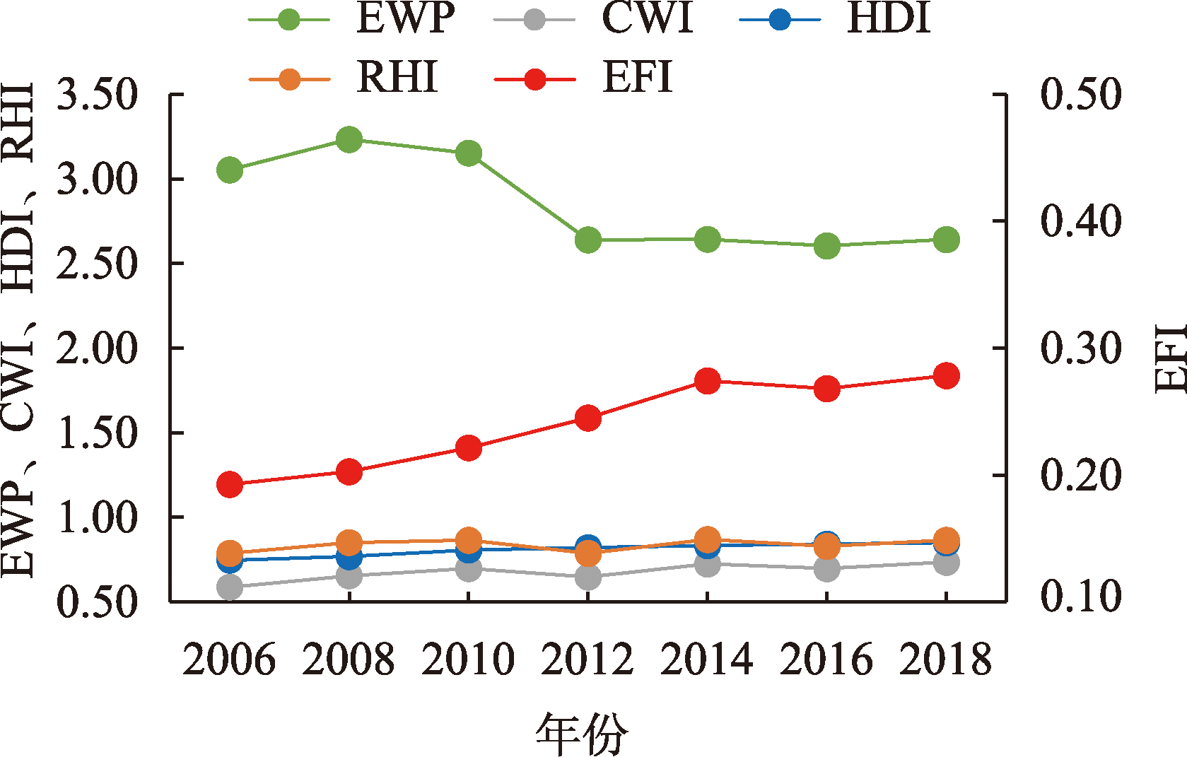
Ecological well-being performance (EWP) is the ecological efficiency of improving human well-being. Analyzing the spatial and temporal patterns and driving effects of EWP can help reveal regional differences in ecological efficiency of human well-being enhancement in China and its causes. This study analyzed the evolution of the spatiotemporal patterns of EWP in China based on a comprehensive subjective and objective well-being perspective, and used the Logarithmic Mean Divisia Index (LMDI) method and Stochastic Frontier Analysis (SFA) method to reveal the driving effects of EWP changes and the determinants of economic growth effect in China. The results show that: 1) The changes in EWP in China in 2006-2018 relied mainly on the effect of economic growth, but the overall level of EWP decreased due to the constraints of environmental well-being effect and social well-being effect. Among the determinants of the economic growth effect, technological progress played the most important role. 2) The differences between the mean values of EWP of southern and northern provinces in China had increased from 0.762 to 1.005, showing a spatial variation of high in the south and low in the north. The economic growth effect value in the south was much higher than that in the north, which was the main reason for the widening of the north-south differences in EWP in China. 3) The change in EWP in China as a whole appeared to be driven by economic growth, with only Beijing, Tianjin, and Shanghai showing a change driven by economic growth + environmental well-being improvement. There was a significant regional heterogeneity in the determinants of the economic growth effect in the southern and northern regions and in eastern, central, and western China. The results of the study can provide reference suggestions for promoting the coordinated regional development of EWP in China.
Urban-rural integration (URI) is a new idea to guide the urban-rural transformation in China, and exploring the spatio-temporal characteristics and driving mechanism of URI in China is an urgent need to overcome the dilemmas of insufficient rural development and unbalanced urban and rural development. Based on the process framework of "foundation-motivation-result" of URI, an evaluation indicator system was constructed. The improved entropy evaluation model and the kernel density estimation method were used to quantitatively measure the spatiotemporal evolution characteristics of URI level of 31 provinces, autonomous regions, and municipalities in China's mainland from 2000 to 2020. This study further used the Geodetector to explore the heterogeneous evolution of driving factors for URI level in different regions of China. The main conclusions are as follows: 1) From 2000 to 2020, the URI level in China decreased first and then increased, showing a √-shaped trend, and its spatial differences narrowed. 2) The URI level in China presented a spatial pattern of high in the east and low in the west, divided by the Hu Huanyong Line. The high-value centers showed prominent polarization characteristics and presented a zonal aggregation trend. The medium-value areas were clustered but weakened,and showed a spreading trend from the eastern to the central and western parts. 3) At the national scale, the core influencing factors of URI level were population mobility, economic development level, urban-rural income gap, and educational supports, potential factors were the optimization of industrial structure and the opening-up level, and threshold effect existed in investment benefit and government intervention. At the regional scale, the core driving forces of URI level in China showed obvious spatial heterogeneity, and in 2020 they were economic development level, investment benefit, and government intervention in the eastern region, investment benefit, opening-up level, and urban-rural income gap in the central region, are educational supports, government intervention, and the optimization of industrial structure in the western region. The interaction of driving factors had far more influence on URI level in China than individual factors, and the interaction between traffic accessibility and other socioeconomic factors had been significantly enhanced. Research on the spatio-temporal evolution and mechanism of URI in China can provide theoretical basis for rural revitalization and high-quality urban and rural development.
Rural revitalization needs to consider the regional differences in rural development, scientifically grasp the spatial characteristics of rural functions, reveal the spatial heterogeneity of the interaction between rural functions, and explore the unique value and multiple functions of rural areas in great depth. Based on the analysis of the connotation of rural multi-functionality from the perspective of production-living-ecological functions, this study used multi-source data such as points of interest and land use to construct the evaluation indicator system of rural multi-functionality, employed a functional index measurement model, global spatial autocorrelation, Spearman correlation analysis, and geographical weighted regression (GWR) to analyze the spatial pattern of rural production-living-ecological functions and the spatial heterogeneity of their interaction in 1636 towns of Shandong Province, and then classified the spatial differentiation types of rural functions and put forward the corresponding development strategies. The results show that: 1) The spatial pattern of rural production-living-ecological functions has obvious agglomeration distribution and spatial differentiation characteristics. The production function relies on the driving effect of the urban core area, showing a ring structure around the urban core area. The areas of predominately living function are mainly distributed on inland plains. The predominately ecological function areas are mainly distributed in mountainous hills of central and southern Shandong, hilly areas of eastern Shandong, and northern coastal areas of Shandong Province. 2) There are both similarities and differences between the overall and local relationships of production-living-ecological functional interactions, and the local relationships have obvious spatial heterogeneity. From the perspective of overall relationship, production function and living function are significantly positively correlated, production function and ecological function are not significantly correlated, and living function and ecological function are not significantly correlated. 3) According to the theories of rural functional space differentiation, the township-level rural space in Shandong Province was divided into eight functional types, the quantitative differentiation of interactions between different types of functions was revealed, and preliminary recommendations for the future development of different types of rural areas were put forward. The research results provide some reference for building a Qilu Model for rural revitalization, and provide a technical support for the formulation of differentiated collaborative development paths of rural functions.
As an important measure to improve the institutions and mechanisms for coordinated regional development, the new urbanization is of great significance for reversing the unbalanced development between urban and rural areas and between different regions, and promoting high-quality economic development. Taking Sichuan Province as the research object and adopting the spatial autocorrelation analysis method, the spatial econometric model, and the threshold panel model, this study analyzed the spatiotemporal change of the new urbanization and urban-rural income gap, discussed the relationship between them, and verified other influencing factors of urban-rural income gap. The conclusions are as follows: 1) In 2009-2019, the level of new urbanization was rising year by year, and annual urban-rural income gap were continuously narrowing. Urban-rural income gap in each year showed significant spatial autocorrelation, with the low value areas concentrated in the Chengdu-Chongqing economic corridor, and the high value areas concentrated in western Sichuan and the Qinba Mountains area in the northeast. 2) The new urbanization had a nonlinear impact on urban-rural income gap, showing an inverted U-shaped relationship, the main reason of which was that the new urbanization and agricultural modernization were not coordinated and synchronized. Only when the level of agricultural modernization crossed the threshold, would the new urbanization curb the widening of urban-rural income gap. 3) Degree of regional economic imbalance, scientific and technological innovation, and human capital level were also significant factors that affect urban-rural income gap. The research results may provide theoretical support to steadily promote new urbanization and to narrow the urban-rural income gap effectively.
Consolidating and expanding the achievements of poverty alleviation is an important task during the 14th Five-Year Plan period. Improving the livelihood sustainability of farming households is the key to prevent the return to poverty and achieve high-quality development in poverty alleviation areas. From the perspective of livelihood sustainability, a systematic evaluation of the effects of the targeted poverty alleviation (TPA) policy provides an important basis for achieving these goals. In this study, an evaluation framework was constructed from the dimensions of livelihood capital, livelihood environment, and intergenerational development capacity. Taking Shizhu County in the Wuling Mountains as the study area, this research used the difference-in-differences (DID) and propensity score matching (PSM)-DID methods to quantify the effects of the TPA policy and discussed the differentiation of policy effects. The findings are: 1) The TPA policy improved the livelihood sustainability level of farming households by 20.5%, and improved the livelihood capital, livelihood environment, and intergenerational development capacity by 21.3%, 23.9% and 15.8%, respectively. The improvement of livelihood environment was more prominent, while the improvement of intergenerational development capacity was relatively weak. 2) The TPA policy had a greater and significant effect on farming households with multiple livelihood strategies, followed by agriculture-oriented households and off-farm employment-oriented households, while subsidy-dependent households with "blood transfusion" assistance were marginalized. The TPA policy aggravated the differentiation of livelihood sustainability among groups. 3) The effect of the TPA policy showed spatial specificity. Compared with Wangchang Town and Huangshui Town that had better basic economic conditions, TPA had a higher and more significant impact on Longsha Town that has locational advantages and Zhongyi Town that was at a deeper poverty level. 4) Countermeasures and recommendations were put forward to consolidate the achievements of poverty alleviation from the aspects of continuously strengthening education and technology input, intensifying efforts to alleviate poverty in remote areas, and providing policy-based guidance for the governance of poor marginal groups. The research provides a theoretical basis for improving the matching and accuracy of policies to consolidate the achievements of poverty alleviation, which may help deepen the understanding of China's anti-poverty theories and practice.
Accessibility is one of the most important concepts in transportation geography. Accurate evaluation of accessibility is of great significance for transportation planning and development. However, there is a lack of literature on accessibility assessment that considered seasonal variation and mountainous terrain influence. The Qinghai-Tibet Plateau is characterized by distinct rainy season and snow season, as well as high altitude and complex terrain. Therefore, this study fully considered seasonal and terrain influences in the evaluation of accessibility. Combined with multi-source data, the cost-distance model was adopted in this study to evaluate the road accessibility in the Qinghai-Tibet Plateau region. The results are as follows: 1) The shortest time to basic service facilities in the Qinghai-Tibet Plateau region during the rainy season considering the influence of precipitation had little change compared with the situation without considering the influence of precipitation. In the rainy season, the average value of the total accessibility of the whole region increased by 0.011 hours, and more than 0.021% of the areas could not reach the nearest service facilities within 8 hours because of the impact of rainfall. 2) Affected by snow cover, the total accessibility of the Qinghai-Tibet Plateau region became worse, and the minimum road accessibility time in the snow season increased by 2.04 hours on average. Given the effect of snowfall, more than 5.41% of the areas could not reach the nearest service facility within 2 hours, and more than 5.54% of the areas could not reach the nearest service facility within 2-4 hours. 3) According to the seasonal change of accessibility affected by precipitation and snow cover in the rainy season and snow season, the fluctuation range of accessibility in the snow season was larger. The areas with the greatest impact on accessibility by precipitation mainly concentrated near the Mount Qomolangma and the Yarlung Zangbo River Grand Canyon, while the areas that were most seriously affected by snow cover mainly concentrated in the eastern part of Tibet Autonomous Region, the southern part of Qinghai Province, and the western part of Sichuan Province, which are mainly distributed in the Hengduan Mountainous area, Tanggula Mountains range, Bayan Har Mountains range, and other topographic areas.
In the process of rural revitalization, it is of great social relevance to comprehensively and systematically identify the dynamic values of traditional villages and evaluate them objectively and effectively. In the face of the diverse and dynamically evolving traditional villages, the traditional standardized evaluation system can hardly adapt to the changing development reality, so the construction of a more flexible evaluation model is a key technical problem that needs to be solved. This study aimed to identify the composition, relationships, and characteristics of dynamic values from three aspects: spatial functions, landscape imagery, and humanistic spirit. A multidimensional evaluation framework including resource value, element continuity, dynamic conditions, functional adaptation, dynamic effects, and development potential was constructed, and a flexible evaluation model consisting of 3 types and 50 indicators was formed. The study used 54 national-level traditional villages in Northern Shaanxi as cases for validating the model. The study results show that: 1) Five characteristics of the dynamic values of traditional villages are distinctive, which include multiplicity, integrity, dynamicity, vulnerability, and adaptability. 2) The flexible multidimensional assessment model results basically conform to the development reality in Northern Shaanxi, and show significant differences in different evaluation dimensions, highlighting the unique values of different types of traditional villages. 3) In a comprehensive analysis, the dynamic values of the 54 national-level traditional villages in Northern Shaanxi are in the range of 42.42-83.60, with an average score of 62.55, and the percentage of traditional villages with high dynamic value and above is about 39%, and the percentage of traditional villages with average dynamic value and below is about 61%, so the problem of insufficient level of development of the dynamic values of a large number of traditional villages still exists in the region. The flexible multidimensional evaluation model of the dynamic values of traditional villages has the characteristics of wide applicability and representativeness, is applicable to the actual situation of traditional villages of various types, and can accurately and objectively reflect the value assessment in multiple dimensions, which is better adapted to the realistic needs of rural revitalization and heritage conservation at the present stage. This research enriches and promotes the theoretical study and practice of the value evaluation of traditional villages by exploring the technical improvement from unidimensional static evaluation to multidimensional dynamic evaluation.
Constructing a vibrant urban space by optimizing urban built environment is a significant measure to shape and develop urban vitality. However, the nonlinear and threshold effects of variables on urban dynamics are often overlooked in most existing studies. In this study, we used the Wuhan metropolitan area at the weekend as a case to quantify the spatiotemporal pattern of urban vitality with population heat data in 2019. We investigated the nonlinear influence of urban built environment on urban vitality and extracted the optimal thresholds for key variables with the gradient boosting decision tree-Shapley additive explanations (GBDT-SHAP) model. The results indicate that: 1) The distribution of urban vitality showed distinct spatiotemporal and functional heterogeneity in the Wuhan metropolitan area. Spatially, urban vitality showed an overall characteristic of high in the center and low at the periphery; temporally, it gradually increased from 7:00 a.m. and peaked in the afternoon and evening; functionally, urban vitality was higher in areas with better infrastructure facilities and near large shopping centers, and lower in industrial areas. 2) The built environment in the Wuhan metropolitan area significantly affected the intensity of urban vitality, and its nonlinear influences and threshold effects were significant: the impact threshold for large shopping centers was roughly 3000-4000 m; the impact of subway on urban vitality was mainly in the intra-city area and the subway stations served the areas within 1500 m; the point of interest (POI) mix above 0.4 inhibited urban vitality. The SHAP values compensated for the shortcomings of traditional multivariate linear models in terms of interpretability. 3) The three variables of distance to central business district (CBD), distance to subway stations, and sky openness and business type have time-varied effects, and the importance of their impacts on urban vitality changes over time. Implementing the transit-oriented development (TOD) concept and improving the connection of metro traffic with large shopping areas are effective measures to enhance the vitality of the city. Setting up outdoor open space promotes residents’ morning exercise and social activities. Adding small dining and recreational spaces is also a measure to enhance vitality. These nonlinear effects and thresholds help planners make better decisions.
Urban health examination is an innovative measure to promote the high-quality development of urban human settlements and improve subjective well-being (SWB) of urban residents in China. However, few studies have focused on the impact of public evaluation of urban health on urban residents' SWB. Drawing on a large-scale questionnaire survey of eight cities in the Yangtze River Delta region collected from the urban health public satisfaction survey conducted by the Ministry of Housing and Urban-Rural Development in 2021, this study used principal component analysis and multiple regression analysis to explore principal components of perceived urban human settlement quality in the region and their impacts on urban residents' SWB, which aimed to put forward the high-quality development strategy of urban human settlements in the Yangtze River Delta region from a people-oriented perspective. The results indicate that: 1) Public satisfaction survey of urban health can extract seven principal components in terms of perceived urban human settlement quality, including urban management, urban vitality, urban comfort, urban livability, urban inclusiveness, urban safety, and urban convenience, and their cumulative contribution rate reached 66.767%. 2) All principal components of perceived urban human settlement quality had a significant impact on the SWB of residents in the region, but the impact direction of different principal components of perceived urban human settlement quality varied. More specifically, the principal components of urban management, urban vitality, urban comfort, urban livability, and urban inclusiveness had a significant positive impact on SWB, while the principal components of urban safety and urban convenience had a significant negative impact on subjective well-being. 3) The impact of perceived urban human settlement quality on SWB not only changed by different sized cities, but also varied by household registration type and age of residents. The findings can play an important role in decision making to promote urban residents' SWB via urban human settlement environment improvement in the Yangtze River Delta region.
As the core element of informal institutional environment, social trust has a complex and important impact on regional entrepreneurial activities. Due to the different social distance and communication objects, there are obvious differences in the form and mechanism of social trust, but the existing research rarely pays attention to the impact of the sub-dimensions of social trust on regional entrepreneurship. This study constructed a social trust framework from the three dimensions of universal trust, kinship trust, and institutional trust, and conducted an empirical analysis by using the panel data of the China Family Panel Studies (CFPS) 2012-2018 and the micro data of enterprise industrial and commercial registration information. The research found that: 1) At the national scale, kinship trust significantly improved the activity of regional entrepreneurship, while universal trust and institutional trust had little impact on the entrepreneurial system. 2) The results of interaction effects show that there was a substitution effect between universal trust, kinship trust, and economic development; there was a complementary relationship between the effects of universal trust and government intervention on regional entrepreneurial activities; and institutional trust and government intervention showed a mutually reinforcing effect, which jointly promoted regional entrepreneurial activities. 3) Regional heterogeneity tests show that entrepreneurial activities in the eastern regions was less dependent on social trust; entrepreneurial activities in the central and western regions was positively influenced by universal trust and kinship trust; entrepreneurial activities in cities with good business-government relations was promoted by institutional trust, where the entrepreneurial policy dividend was effectively released; and in cities with average business-government relations, universal trust could significantly promote entrepreneurship and stimulate entrepreneurial vitality. This study focused on the impact of different dimensions of social trust on regional entrepreneurial activities, which enriches and expands the research on informal institutional environment and entrepreneurship, and has important implications for local enterprises to formulate entrepreneurial policies and optimize the entrepreneurial environment.
The government, enterprises, and other non-governmental organizations (NGOs) participate actively to help poor rural households get rid of poverty in targeted poverty alleviation programs in China, which leads to the transformation of rural relational space. From the perspective of actor-network theory (ANT), this study focused on the case of targeted poverty alleviation at Hebian Village, Mengla County, Yunnan Province after 2015. Using participatory observation, semi-structured interview, and questionnaire survey methods, we collected first-hand material about the targeted poverty alleviation program in the village. Then we constructed a framework about spaces of prescription and spaces of negotiation to analyze the poverty alleviation effort that all actors were involved, which helped put forward the explanation of the transformation of relational space in ANT by finding that: 1) There were periodic features in the transformation of relational space at Hebian Village after the implementation of targeted poverty alleviation in 2015, including the previous relational space for poverty alleviation (with bigger space of prescription) and the following relational space for consolidating the work of poverty alleviation (with bigger space of negotiation). 2) The transformation of relational space within a certain stage means the process from the space of prescription to the space of negotiation, affected by the applied prescriptive actions. For example, it was easy to target the obligatory passage point (OPP) and promote the process in the previous relational space, because of the bigger space of prescription constructed by explicit policy goals such as "safe housing". 3) The transformation of relational space between stages means the process from the previous space of negotiation to the following space of prescription. Considering the high satisfaction of farmers and the new prescriptive actions, it was proved that there was a stable new space of prescription and the transformation of relational space after the village got out of poverty at the end of 2018. 4) The transformation of relational space had also contributed to the transformation of farmers, who had been mobilized in the improvement of the built environment in the previous relational space. As key actors in the following relational space, they were expected to play a bigger role to consolidate the work of poverty alleviation and revitalize the village. The transformation framework of relational space constructed in this paper has both theoretical value and practical meaning for analyzing and promoting the development of rural areas.
Freezing damage results in the dehydration of plant cells and reduces the photosynthetic capacity of plants, which causes significant losses to ecology and economy. Over the past 40 years, global warming has reduced the frequency and intensity of frost events while bringing forward the spring phenology of plants, increasing the exposure of their leaves and flowers to harsh cold temperatures. Therefore, the dual effects of climate warming should be considered in order to accurately assess the changes of plant freezing damage. To date, there is no systematic analysis of plant freezing damage in different climatic regions of China. Based on phenological observation records from the China Phenological Observation Network, leaf frost damage of four common woody plants (Ulmus pumila, Robinia pseudoacacia, Salix babylonica, Fraxinus chinensis) in the spring over the past 40 years was calculated, and the spatio-temporal patterns were analyzed. We also investigated the change in the occurrence time of maximum frost damage (TMFD) and its relationship with plant phenology. The results show that: 1) Most species presented an overall trend towards an earlier leaf unfolding date, and the advancing trend was significant and greater than 1 d/a in about 60% of the regions (P<0.05). 2) The TMFD occurred earlier in 72.22%-83.03% of the regions, which was closely related to plants' earlier leaf unfolding date. The TMFD of all species advanced the most (8.3 days) in the temperate climate zone, followed by the warm temperate, subtropical, plateau, and cold temperate zones. 3) The leaves of U. pumila, R. pseudoacacia and S. babylonica suffered more freezing damage in the spring, and the most significant freezing damage was mainly found in the north of 50°N region and part of the west of the Qinghai-Tibet Plateau. In comparison, the leaves of F. chinensis suffered less frost damage due to later leaf unfolding date and stronger leaf frost resistance. With regard to interannual variations, the average freezing damage of U. pumila, R. pseudoacacia and S. babylonica increased significantly (P<0.05), but that of F. chinensis did not change obviously. In addition, the freezing damage of U. pumila and S. babylonica increased the most in the cold temperate zone, while that of R. pseudoacacia increased in about 10% of the regions in the plateau climate zone, and 3%-6% of the regions in the cold temperate, temperate, and warm temperate climate zones. The freezing damage of F. chinensis merely increased in the warm temperate zone. The results of this study can provide a reference for assessing the risk of plant freezing damage accurately and help develop regional-specific response and adaptation strategies to climate change.
In the era when information, labor, capital, and commodities are extremely mobile, knowledge increasingly shows multi-locational interactions characterized by the coexistence of interaction between neighboring areas and interaction between distant places, which has an important impact on regional economic development. Based on a series of changes in the current human social and economic systems, combined with the inherent inadequacies of the traditional regional innovation research paradigm, this article introduced the territorial knowledge dynamics theory with knowledge combination as the core. According to the theory of territorial knowledge dynamics, knowledge combination is the key driving force of regional innovation, characterized by multi-scale networks. The combination of different types of knowledge is realized through interaction between neighboring areas or interaction between distant places in space. According to the spatial pattern of knowledge combination, territorial knowledge dynamics can be classified into multi-locational knowledge dynamics and networks of distant knowledge dynamics. This study built an analytical framework of multi-locational knowledge dynamics for regional economic development. By introducing trust and learning mechanisms, this framework analyzes the mechanism of influence of local contexts, such as formal/informal institutions and cognitive level, on knowledge interaction and combination. Based on the external knowledge linkages and knowledge network externality, this framework explores the path and mechanism of influence of multi-locational knowledge networks on the evolution of regional industrial comparative advantage and endogenous economic growth. Finally, the logic of regional governance in the era of the knowledge economy was summarized from four dimensions: regional governance, regional strategic guidance, policy tools, and knowledge impact. The study of multi-locational knowledge dynamics promotes the regional innovation school's research on knowledge dynamics in regional economic development. It is also helpful for scientifically formulating policies for regional collaborative innovation and high-quality economic development.
Small towns occupy a vital position in the urban and rural settlement system and are one of the main settlement types of humankind. Since the middle of the twentieth century, small towns in Western developed countries have gradually started transitional development. Their overall decline and differentiated development have become a universal phenomenon worldwide. With the increasing interaction between urban and rural areas and global mobility, small towns are increasingly influenced by forces at the regional, national, and global scales. Therefore, this study systematically examined the relevant studies on the transformation and development of small towns in developed countries and summarized the processes and patterns of their transformation and development based on the perspective of multi-scalar characteristic and rescaling from the four dimensions of economy, society, culture, and policy, with the hope to provide a reasonable explanation for the transformation and development of small towns in developed countries. This study holds that small towns have a multi-scalar characteristic and can be embodied by ladder scale, nested scale, and network scale metaphors. The transformation and development of small towns contain the process of scale production and reproduction and can be further divided into four dimensions of economy, society, culture, and policy. Under the background of globalization and urbanization, the original core-periphery structure of small towns is undergoing a trans-scale and networked scale restructuring process. Some small towns tend to decline in this process, while others can become nodes in the global network scale, achieve a development transition in the ladder scale, and expand the hinterland in a nested scale. Finally, this article argued that it is necessary to pay attention to the differences in different contexts when we examine the transformation and development of small towns in China based on the rescaling theory. There is still a considerable gap in the research on the pluralistic differentiation and transformation and development of small towns in China, which urgently needs to be supplemented by theoretical research of urban and rural geography to provide theoretical support for the planning and construction of small towns in China.
In the context of high-quality development, the conflicting relationship between tourist areas and surrounding communities has become a severe obstacle to the realization of high-quality economic development. As a theoretical tool to describe the relationship between tourist areas and surrounding communities, the concept of tourism island is of great value in identifying, assessing, and managing the conflicts between tourist areas and surrounding communities. Therefore, it has gradually become a new topic in geography, sociology, economics, and other related disciplines. On the basis of distinguishing and analyzing the three interrelated concepts of tourism enclave, tourism bubble, and tourism island, this article systematically reviewed the research progress from the four aspects of tourism island types, key characteristics, causes of formation, and impacts, and found that the current research still has obvious deficiencies in theoretical framework, empirical research, and governance system. Finally, this article proposed three specific directions for further research based on the shortcomings of the current research. Based on the practice of Chinese tourism development, a theoretical framework of tourism island should be constructed, the formation processes and impacts of tourism island should be explored using diversified methods of analysis, and a multi-dimensional, multi-level, and multi-process regulatory mechanism should be developed. Overall, this article presented a systematic review of the previous research literature on tourism island to show their results and quality; it also clarified the starting point for further research and laid a foundation for new research works.