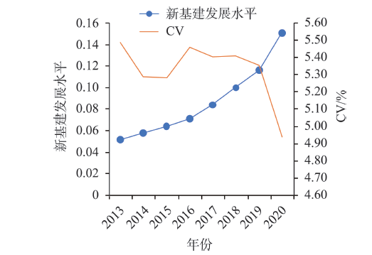
New infrastructure has become an important support for China's economic transformation and high-quality development in the new era. In order to investigate the temporal and spatial evolution of China's new infrastructure development and its driving factors, this study first constructed a comprehensive evaluation index of the development level of new infrastructure based on the provincial panel data from 2013 to 2020. Then, it used the technique for order of preference by similarity to ideal solution (TOPSIS) entropy method and spatial econometric model to measure the development level of new infrastructure and analyze its driving factors. The results show that: 1) The development level of China's new infrastructure has increased year by year, and there is a trend of balanced development among provinces. 2) There is great spatial heterogeneity in the development level of China's new infrastructure. The new infrastructure development level is much higher in the eastern region than the central, western, and northeastern regions. The overall temporal and spatial evolution pattern showed an east-west expansion trend, and the center of gravity continued to move to the southwest. 3) The development level of new infrastructure is affected by many factors, among which the economic development level, financial development level, innovation foundation, urbanization process, and population size are the key driving factors. By examining the evolution of the spatial pattern of China's new infrastructure development level and its influencing factors, this article may provide a decision-making reference for its optimal layout and development.
Formally, outward foreign direct investment (OFDI) is a cross-country interaction, with the motivation and location that vary dramatically across the different sectors of value chains. Based on the FDI Markets database, this study built a global OFDI network, and explored the evolutionary characteristics and spatial patterns in different sectors (including Headquarter and R&D, Extraction, Manufacturing, and Marketing) through network analysis. This study found that: 1) The global OFDI networks exhibit a core-peripheral structure and there are significant differences in different sectors, with the highest connectivity in the Marketing network, the most pronounced small-world nature in the Headquarter and R&D network, and the de-networking trend in the Extraction network. 2) The spatial patterns of OFDI networks vary across different sectors. Specifically, the Headquarters and R&D network shows reciprocal investments between developed and emerging economies as well as rapid expansion, while the Extraction network tends towards large and one-off investments. In the Manufacturing network, developed countries play a predominantly home country role while developing countries are embedded as host countries more, and the high proportion of two-way investment flows in the Marketing network reflects fierce competition in the global market. 3) The spatial patterns of advantaged investment countries are very different, and they can be summarized in four points, including "big in and big out" in the Headquarters and R&D network, "polarization" in the Extraction network, "gradient shift" in the Manufacturing network, and "ubiquitous dominance" in the Marketing network.
In urban agglomerations, the environmental impact of urban industries may spillover between cities not only through the pollution diffusion, but also through the inter-city linkages of industrial investment and transfer. The spillover effect of urban industries on air quality through the urban industrial investment network has been largely ignored in the literature. Due to the urban network externality, the air quality in a city is not only influenced by its own industrial activities, but also closely related to the industrial development of other cities connected through the industrial investment in the urban network. By applying the investment data of manufacturing enterprises among cities in the Beijing-Tianjin-Hebei region from 2004 to 2018, this study investigated the characteristics of the inter-city manufacturing investment network in the region. This study created inter-city manufacturing investment network matrices under a spatial econometric model to empirically test the spillover effect of urban industries on haze pollution via the inter-city manufacturing investment network in the Beijing-Tianjin-Hebei region. The findings suggest that the investment in polluting manufacturing has increased significantly under the mutual investment in manufacturing between cities in the region. Furthermore, compared with other types of manufacturing investment, the polluting manufacturing investment network among cities in the Beijing-Tianjin-Hebei region is more dispersed. Those extensive investment linkages in polluting manufacturing industries between cities in the region are important channels for the spillover effect of urban industries on haze pollution. From the perspective of spatiotemporal evolution, our results indicate that the gradual expansion of the network of polluting manufacturing investment between cities in the Beijing-Tianjin-Hebei region is more likely to generate extensive cross-city environmental impacts. Our empirical results confirm the spillover effect of urban industries on haze pollution via the inter-city manufacturing investment network. The transmission mechanism of this spillover effect is based on the investment linkages between cities and depends on the types of invested industries. Specifically, the polluting manufacturing investment linkages result in more significant and stronger spillover effects of urban industries on haze pollution through the urban network. Therefore, the coordinated development of urban industries among cities in the urban agglomeration is necessary for meeting the regional environmental and sustainability challenges.
The 2008 global financial crisis had a huge impact on China's real economy, and inspecting the imbalance and differentiation mechanism of the regional economic recovery process after the crisis is conducive to providing a reference for promoting regional high-quality and sustainable development. Based on the multidimensional resilience measurement framework, this study comprehensively investigated the dynamic evolution process of economic resilience in the Yangtze River Economic Belt after the 2008 global financial crisis, and focused on the temporal variation characteristics and spatial differentiation patterns of resistance and resilience. On this basis, the fixed effect panel regression model was used to analyze the role of factors such as industrial development status, regional development foundation, level of opening up, government management level, and innovation environment on economic resilience. The study found that at the overall level, the resistance of the Yangtze River Economic Belt after the impact showed a trend of first rising and then declining and the overall performance was high, but the resilience showed a trend of decline-rise-decline and the overall performance was low. The fluctuations in export resistance and resilience were much greater than the fluctuations in the dimensions of GDP, industry, consumption, and employment. Regression models showed that diversity and related diversity and regional innovation capabilities, although limited in the process of resisting risks in the early stage of the crisis, were conducive to the rapid regional resumption of growth after the crisis, areas with strong government management capabilities may hinder economic recovery to a certain extent, and the ability to open up to the outside world has no significant impact on resistance and resilience.
China began to implement marine economic development pilot policies from 2011 in order to promote land and marine development in a coordinated way, transform and optimize marine industrial layout, formulate and improve the policy and institutional construction of ocean development, promote marine economic power strategy, and improve the level of regional economic resilience in coastal area. Tourism industry is an important part of regional economy of coastal areas. Taking the marine economic development pilot policies as a quasi-natural experiment and based on the panel data of cities in coastal areas of China from 2007 to 2020, a multi-period difference-in-differences (DID) model was used to assess the impact of these pilot policies on regional economic resilience and tourism economic resilience. The results show that the implementation of marine economic development pilot policies can significantly promote regional economic resilience and tourism economic resilience. COVID-19, as a moderating variable, has significantly weakened the effect of marine economic development pilot policies on regional economic resilience. In terms of regional heterogeneity, the establishment of marine economic development pilots has a more significant policy effect on regional economic resilience in the central and southern coastal areas, while the policy effect on tourism economic resilience is more significant in the eastern coastal areas. In view of these findings, it is of great significance for cities to prevent systemic risks and improve regional economic resilience, by means of reasonably expanding marine economic development pilots and planning coastal regional economic systems according to local conditions.
Scientifically diagnose the spatial conflict of resource-based cities and clarify the complex relationship between spatial conflict and land use are important for urban development transformation and rational use of regional resources. Based on the characteristics of resource-based cities, this study constructed a spatial conflict measurement model considering spatial pressure, spatial exposure, and spatial risk response dimensions with the perspective of land use and ecosystem service value, and explored the relationship between spatial conflict and land use using a geographically weighted regression model. The results indicate that: 1) From 2009 to 2020, the spatial conflict index of Xintai City remained stable with a change of 0.0018 only. The change trends of different conflict levels varied. The spatial pattern was zonal, and the conflict level gradually decreased from the center to the peripheral areas. 2) From 2009 to 2020, the average land use dynamic degree of Xintai City was 23.14%, the spatial layout was significantly different, and the land use changes were mainly cultivated land conversion to woodland, land reclamation, expansion of construction land, and afforestation. 3) Based on the analysis of the geographically weighted regression model, the dynamic degree of land use was significantly correlated with the change of spatial conflict index (P < 0.01, R2 =0.8517), and the average coefficient value was 0.1381, dominated by positive correlation. The research provides a scientific basis for the rational use of regional land, governance of spatial conflicts, and optimization of spatial structure in the city.
Scientifically identifying the pattern, process, and mechanism of the old-new growth driver conversion in the Shanxi-Shaanxi-Inner Mongolia region is an urgent requirement for narrowing the regional development gap and achieving high-quality development in the region. On the basis of constructing a theoretical framework for regional old-new growth driver conversion and with the aim of promoting regional coordinated high-quality development, this study examined the process of old-new growth driver conversion and the spatiotemporal differentiation mechanism in the Shanxi-Shaanxi-Inner Mongolia region at the city scale in 2005-2019 from the four dimensions of driving force, institution, structure, and mode. The results show that: 1) The level of old-new growth driver conversion in the Shanxi-Shaanxi-Inner Mongolia region showed a trend of first fluctuating and decreasing and then rising rapidly, and the gap of old-new growth driver conversion between cities is gradually widening. 2) The overall level of old-new growth driver conversion in the region is low, showing a core-periphery structure spatially, with the provincial capital cities as the cores. The advantageous and leading areas showed a dotted distribution pattern with provincial capital cities as the cores, and the lagged and medium-level areas are widely distributed in non-provincial capital cities. 3) The negative spatial correlation of old-new growth driver conversion in the region is obvious, showing the spatial differentiation characteristics of cold spot agglomeration and hotspot dispersion, and a health interaction mechanism of old-new growth driver conversion between cities has not yet been formed. 4) The geographical differentiation of old-new growth driver conversion in the Shanxi-Shaanxi-Inner Mongolia region is the result of the comprehensive action of multiple elements, and human capital, urban scale, and the level of informatization are the core driving factors. This study indicates that cultivating innovation talents, enhancing the ability of agglomeration and transformation of innovation resources, and strengthening informatization development are the key paths to promoting the old-new growth driver conversion and coordinated and high-quality development in the region.
Emergency evacuation guidance is important in the safety planning of urban open public places. In order to solve the problem of spatial allocation of evacuation leaders at the early stage of emergency evacuation, a new allocation optimization method of evacuation leaders in open public places was built based on the particle swarm algorithm and gradual covering model. The method considers the influence of obstacles on the intervisibility, the spatial covering range, the distance decay effect of leaders' guidance, and the guided evacuee number threshold for each evacuation leader. Taking Binjiang Green Space in Xuhui District, Shanghai Municipality as an example, we conducted the allocation optimization of evacuation leaders. Using the agent-based evacuation model, emergency evacuation guidance simulations were conducted to verify the feasibility of the method by comparing the evacuation efficiency before and after the optimization. Meanwhile, considering the difference of crowd distributions in several time periods of a day, the dynamic planning of leaders' responsibility areas was conducted. The analysis results show that the demands for evacuation leaders varied at different moments and were proportional to the number of evacuees. The evacuation time cost of the optimized evacuation leader allocation scenario was much lower than that of the artificial allocation scenario. The division of the evacuation leaders' responsibility areas helped to clarify the area that each leader was responsible for and the daily safety precautions that should be taken under the limited leader number situation. This study can provide a decision basis for the spatial allocation of evacuation leaders in urban open public places, reduce the potential safety risks, and promote the construction of urban public safety.
Human resources are the basis for the spatial development of rural areas. Encouraging migrant workers to return to their hometown for employment is an important measure for promoting rural revitalization and the fundamental guarantee for achieving common prosperity. This study adopted the fuzzy set qualitative comparative analysis method of multivariable interaction and took the willingness of rural tourism destination residents to return home for employment as the outcome variable to construct a model with place participation, place attachment, perceived benefits, risk tolerance, trust on the government, and support as the influencing variables, and explored the driving mechanism and multiple influence paths of return for employment. The results show that: 1) None of the individual factors constitutes the necessary condition for rural tourism destination residents to return home for employment. 2) There are seven combined paths that meet the conditions, with an overall consistency of 0.876 and an overall coverage of 0.862. 3) In all path combinations, the appearance frequency of support and trust on the government is the highest, and the coverage of paths that include place attachment is high. 4) The seven paths constitute four kinds of path models: attachment dominated path, trust dominated path, support dominated path, and the comprehensive path. 5) When attachment, trust, support, and participation factors are included at the same time, the path has the highest explanatory power. 6) Different types of rural tourism destination show differences in the impact path of returning home for employment. The results of this study provide a reference for encouraging and attracting migrant workers from rural tourism destinations to return home to participate in tourism development, and provide a theoretical basis for more extensive rural areas to encourage talent repatriation.
In order to analyze the impact of COVID-19 prevention and control measures on the hotspots of residential burglary, the data of crimes that occurred during the First Level Response period of Major Public Health Emergencies in Beijing in 2020 and the same period in 2019 were collected, and the changes of hotspots during the two periods were compared by using kernel density estimation and predictive accuracy index. Consequently, the environmental features such as street network, point of interest (POI) diversity, crime locations, and repeat victimization in significantly varied hotspot areas were investigated. The results show that: 1) After the outbreak of the pandemic, the occurrence of residential burglary in the core urban areas of Beijing dropped significantly, and daily occurrence of crimes during the First Level Response period in 2020 decreased by 66.8% compared with the same days in 2019. 2) The eight major hotspots that existed in 2019 apparently declined during the corresponding days in 2020, five of them basically disappeared, and three hotspots weakened. 3) The declined hotspots were generally clustered around traffic hubs, areas with high diversity of POIs, clustered crimes, and repeat victimizations. 4) Home isolation and social restriction strategies implemented during the First Level Response period reduced the opportunities of offenders, and the real-name inspection adopted in public places increased the exposure risk of offenders, which are the main reasons for the hotspots decline during the pandemic. This work has some implications for crime prevention and police resources optimization during the pandemic.
Existing studies show that the outbreak of the COVID-19 pandemic has a significant impact on crime occurrences. However, it remains to be empirically examined whether the regular pandemic prevention and control measures in China can significantly affect the spatial patterns of crimes. To fill this gap, this study chosed the central urban area of Haining City in Zhejiang Province, which had taken the regular pandemic prevention and control measures, as the research area. Using standard deviation ellipse and kernel density estimation methods, this study examined the spatiotemporal patterns of theft crimes between February 2018 and July 2021 in the study area. The results show that: 1) While there were no significant changes in the hourly patterns of theft crimes within a day, the monthly number of thefts in the study area decreased by an average of 53% after the outbreak of the COVID-19 pandemic and fluctuated between 100 to 200 thefts per month. The regular COVID-19 pandemic prevention and control measures had a long-term and stable inhibitory effect on the number of theft crimes in Haining City. 2) The intensity and amount of hotspots for theft crimes in the study area decreased significantly during February 2020 and July 2021 when compared with the pre-pandemic period, and the spatial distribution patterns of theft crimes were relatively s
The erosion effect of rivers on the bank slopes is one of the important factors in the destabilization of loess landslides. Exploring the impact of seasonal changes of river water level on the stability of slopes is important for disaster early warning. The study utilized remote sensing techniques to examine the relationship between the rate of deformation of coastal slopes and seasonal changes in water levels over a five-year period, using the landslide in Qingquan Village, Tianshui City, Gansu Province as a case study. The time series deformation data of the landslide was obtained based on SBAS-InSAR technology, the time series water level data at the bottom of the slope was obtained using MNDWI and DEM, and the time series rainfall data of the study area was obtained through GPM. By comparing the river water level, time series rainfall, and landslide deformation rate curves, we found that as the rainfall increased and the river water level rose, the deformation rate of the Qingquan Village landslide increased significantly, and the landslide deformation rate increased the most during the summer season. In particular, the peak of the slope deformation rate has a certain lag compared to the peak of the water level. The coefficient of correlation between water level and landslide deformation was 0.46, and that between rainfall and landslide deformation was 0.39, indicating that the degree of response of the landslide in Qingquan Village to changes in water level was more pronounced. The seasonal change of river water level causes the seasonal change of river erosion on erosive landslides. The seasonal relationship between the deformation of loess landslides and the water levels of rivers is vital in understanding the evolution of riverbank slopes, recognizing landslides, and preventing disasters.
The Hengshan area in Shaanxi Province is located at the transitional junction of the Loess Plateau and the Mu Us sandy land in China. It is sensitive to environmental changes and has formed a unique paleoaeolian sand loess paleosol sequence. In this study, the L3 and S3 loess paleosol strata of the Liushumao section in Hengshan were selected for the analysis of the element content and related geochemical parameters in soil samples, to systematically explain the chemical weathering intensity and environmental evolution information recorded by the element geochemical index parameters during the L3 loess accumulation and S3 paleosol development in the Hengshan area. The results show that the major elements in the Liushumao section are mainly SiO2, Al2O3 and CaO. There are differences in the content of major elements in loess layers (L3-1, L3-2), paleosol layers (S3-1, S3-2), and aeolian sand layers (L3F, S3F). The contents of Al2O3 and Fe2O3 are the highest in the paleosol layer of the section, the content of CaO is the highest in the loess layer, and the content of Na2O is the highest in the aeolian sand layer. The CIA and Na/K values of the section samples reveal that the loess-paleosol layer are in the stage of primary chemical weathering, and the aeolian sand layer has not entered the stage of chemical weathering. The high values of CIA, Rb/Sr ratio, and magnetic susceptibility in the Liushumao section indicate the strengthening of weathering and pedogenesis, the relatively warm and humid climate in this period, the increasingly strong summer monsoon, and the fixed contraction of the Mu Us sandy land. The high values of the ratio of silicon and aluminium (Sa) and > 63 μm particle content indicate the occurrence of strong winter monsoon, which led to the activation and expansion of the sandy land under the effect of dry and cold climate. One extremely cold period, two cold periods, and a relatively warm period occurred in the L3 loess accumulation period, while two warm periods and one cold period occurred in the S3 paleosol development period. The change of element geochemical indicators in the Liushumao section revealed that the climate change in the Hengshan area was mainly affected by the change of strength of the East Asian winter and summer monsoon, which is generally consistent with other climate change records in North China. The study results provide more evidence for exploring the climate and environmental changes in the transitional area of the Loess Plateau and Mu Us sandy land in China.
Global-local interaction is an important research topic in economic geography. In recent years, the rapid development of digitalization in various countries and regions has profoundly affected the global production and trade networks. However, there is a lack of systematic theoretical discussion on digitalization and global-local interaction studies. The objective of this study is to conceptually rethink the role of digitalization in reshaping global-local interactions from a dynamic and relational perspective. To do this, the study first systematically reviewed the digital turn in economic geography and discussed the rethinking of digitalization. It is found that the understanding of digitalization is gradually moving beyond the limits of isolated, static, and passive technocentric approaches and towards a more dynamic, relational, and open perspective. Second, the study combined the "digital turn" with the "relational turn" in relational economic geography, which constructs theoretical bridges between digitalization and global-local studies. Third, this study provided a basic understanding for sorting out the evolution of the research frameworks, that is, from the global value chain (GVC) to the global production network (GPN) and then to the digital ecosystem (DE). We argued that digitalization has been deeply involved in shaping the global economic landscape, restructuring global-local production relations, and reconstructing regional development. Based on this recognition, we discussed the primary performance of digitalization on the restructuring of global-local interaction from three aspects: enterprise relationship, spatial effect and interaction mechanism. Finally, grounded in the practice of China's urban and regional digital economy development, the possible theoretical innovations and prospects for future research on digitalization and global-local interaction in the Chinese context were proposed. The study pointed out that we can integrate the regional practices of China's digital development with more in-depth research from the perspectives of the platform ecosystems, spatial effects, location analysis, local development models, and so on in future research.
Urban renewal is an inevitable requirement for adapting to the new situation of urban development and promoting the high-quality development of cities. As an integral part of the city, the redevelopment of the urban waterfront has increasingly become an important way to promote urban renewal and participate in global competition. In order to comprehensively understand the status of waterfront redevelopment, this article summarized the relevant progress of urban waterfront redevelopment in China and abroad from the aspects of waterfront concept, waterfront redevelopment concept, spatial process, evolution path, organizational model, and driving mechanism, and examined the research prospects. The findings are as follows: 1) The evolution trend of the spatial process of waterfront redevelopment changes from production to service-economy, and from a single land use type to a multiple land use types. 2) From the evolution of the spatial process, it can be concluded that waterfront areas are mainly redeveloped in four different temporal and spatial evolution paths: material space improvement, high-quality economic development, shared vision of leisure and entertainment, and historical and cultural protection. 3) The organizational model of waterfront redevelopment is mainly divided into three types: government led, private, and public-private partnership. Stakeholders participate in forming the organizational model of waterfront redevelopment, interacting with the social-environmental systems composed of port, environment, economy, politics, culture, and so on and jointly acting on waterfront redevelopment. 4) In the future, the research on urban waterfront redevelopment should focus on the innovation of analytical systems and theoretical research frameworks, pay attention to the research on the dynamic evolution path of waterfront redevelopment, further analyze waterfront redevelopment mechanism and mechanism of influence, strengthen the systematic analysis of the multiple performances of waterfront redevelopment, and establish a waterfront redevelopment management and control method library to promote urban renewal.
Financial inclusion is important for reducing poverty and promoting the sharing of development results. It is an important research topic in international financial geography. Based on 3421 core journal articles in the CNKI database from 2005 to 2021, this study analyzed the basic characteristics and hotspot evolution of financial inclusion research in China using knowledge map visualization techniques. The results show that: 1) Academic achievements went through three stages of slow growth, rapid growth, and accelerated growth. The research hotspots evolved through financial exclusion, financial inclusion, to digital financial inclusion, among which rural areas, regional differences, spatial patterns, and development effects were the common concerns of all stages. 2) The research on financial inclusion in China is interdisciplinary, inclusive, and open. The participation of multiple disciplines promotes the vigorous development of the research on inclusive finance. In the process of interdisciplinary integration, different disciplines have their own concerns. 3) Based on the perspective of financial geography, this study proposed future research topics such as the spatial process of financial inclusion development, cultural and economic factors and relationship networks of local financial inclusion development, the development effect of financial inclusion, and the spatiality of fintech and its potential impact.