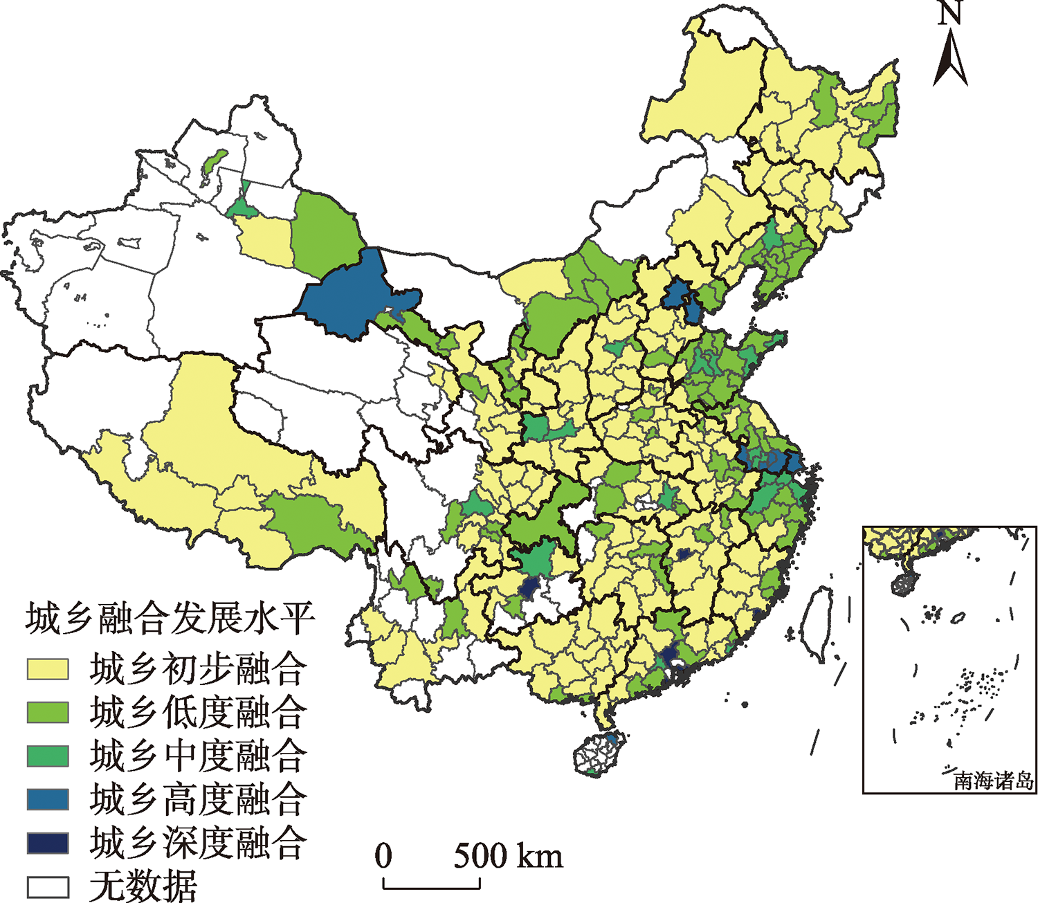
The flow of urban and rural elements runs through the entire process of urban and rural development and is the core of achieving urban and rural integration. Exploring the mechanism of influence of urban-rural element flow on urban-rural integrated development can provide a scientific guidance for breaking the plight of urban-rural integrated development. Based on the technique for order of preference by similarity to ideal solution (TOPSIS) model, this study evaluated the development level of urban-rural integration in 292 cities across China, and used the ordinary least squares (OLS) and geographically weighted regression (GWR) models to explore the impact mechanism of urban-rural element flow on urban-rural integration. The results show that: 1) There are large spatial differences in the level of urban-rural integrated development at the city level in China. Most of the cities that have reached the level of deep urban-rural integration are economically developed. In general, the eastern region has the most balanced urban-rural integration. 2) Overall, the flow of land elements and population elements has the most significant impact on the urban-rural integrated development, and the driving effects of the two are negative. Locally, the influence of the flow of various urban-rural elements on the urban-rural integrated development has obvious regional differences. 3) The loss of land elements of the countryside causes loss of production elements and development space in these areas, and the lost talents have no effective way to return to the countryside, which limits urban-rural integrated development. Government investment promotes the agglomeration of elements and reduces the cost of element flow, urban and rural industries achieve division of labor and complement each other in functions, and the effective flow of information elements reduces allocation costs and improves allocation efficiency of other elements, which are beneficial to urban-rural integration.
Transportation is the physical carrier of knowledge and technology spatial flows such as talent and capital flows in innovation networks, and its impacts on urban innovation capacity have become a cross-cutting frontier in economic geography. Based on the city-scale data of China from 2007 to 2018 and taking air and high-speed rail transportation as examples, this study constructed a theoretical framework for the effect of transportation on urban innovation capacity, adopted the two-way fixed-effects panel regression model to empirically test the multiple heterogeneity mechanisms of aviation and high-speed rail on urban innovation capacity, and explored the mediation effects of knowledge dissemination, capital accumulation, and industrial upgrading between transportation and innovation capacity. The results are as follows: 1) Both aviation and high-speed rail development have significant positive impacts on urban innovation capacity, and the spillover effect of high-speed rail on urban innovation is about three times that of aviation. 2) The innovation spillover effects of aviation and high-speed rail on different types of cities are significantly different. In terms of urban grade heterogeneity, the positive impact of aviation and high-speed rail on the innovation capacity of central cities is higher than that of other cities. In terms of population size heterogeneity, aviation has a significant positive impact on the innovation capacity of large and medium-sized cities and an inhibitory effect on small cities, while high-speed rail transportation has a positive impact on urban innovation capacity of cities of different population sizes, showing the trend of large cities > medium-sized cities > small cities. In terms of regional heterogeneity, aviation and high-speed rail have improved the innovation capacity of the eastern, central, western, and northeastern cities of China in varying degrees with a significant Matthew effect, and eastern China has a prominent dominant position. 3) Both aviation and high-speed rail can indirectly promote urban innovation capacity by stimulating technology transfer, venture capital allocation, and foreign capital allocation. Aviation can also indirectly promote urban innovation capacity by stimulating industrial upgrading.
With the rapid advancement of population urbanization in China, the agglomeration differences between cities caused by asymmetric population flow continue to accumulate and generate spatial polarization. The study of the pattern of polarization formation and its spatial effects is of great practical significance for coordinated regional development. Taking 41 cities in the Yangtze River Delta region as research cases, this study built a comprehensive evaluation indicator system for the level of population urbanization. On the basis of measuring the population agglomeration index from 2000 to 2019, this study used polarization index and coefficient of variation to explore the evolution process, spatial characteristics, and positive- negative effects of the spatial polarization of population urbanization. The research found that: 1) Since 2000, the spatial and temporal differentiation of population urbanization in the Yangtze River Delta region has been increasing year by year, the spatial polarization has increased by nearly 40%, and the unevenness of urban development has continued to increase; The overall polarization of the Yangtze River Delta region is larger than that of the Yangtze River Delta urban agglomeration, forming a multi-center spatial polarization pattern with Shanghai-Nanjing-Hangzhou-Hefei as centers, and the core area has evolved into a spatially positive area. 2) With the change in the degree of agglomeration, the spatial and temporal differentiation of spatial polarization in different dimensions continues to expand. The high-value areas are mainly concentrated along the Yangtze River Delta axis with Shanghai-Nanjing as the center, and then decrease to Anhui, northern Jiangsu, and southern Zhejiang. It presents an obvious core-periphery structure, forming a spatial polarization trend of population quality > population structure > population potential. 3) During the study period, the polarization level of most cities has changed. The increase of positive-positive and negative-negative cities has intensified the spatial polarization effect of the region, showing a dumbbell-shaped distribution characteristic. 4) In the process of population urbanization, population structure is the main driving force of spatial polarization in the region. In the future, continuously improving the population quality and regulating the transformation of positive-positive and negative-negative cities into positive-negative and negative-positive cities will help promote the high-quality and coordinated development of population urbanization in the Yangtze River Delta.
Ecological well-being performance is an important tool to explore the relationship between ecology and human well-being and measure the ecological civilization construction. Based on the panel data of cities of the middle reaches of the Yangtze River from 2005 to 2020, this study used the super-slacks-based measure (Super-SBM) model to calculate the value of ecological well-being performance of the urban agglomeration of the middle reaches of the Yangtze River and analyzed its spatiotemporal evolution characteristics. Based on this, factors driving ecological well-being performance were explored by the panel Tobit Model. The driving mechanism of the evolution was revealed under the carbon peaking and carbon neutrality goals. The study results indicate that: 1) From 2005 to 2020, the ecological well-being performance of the study area showed the characteristics of slow decline→fluctuation→rapid development. 2) The ecological well-being performance of the study area presented a significant core-periphery structure. "Border area collapse" was obvious at the junction of three sub-agglomerations of Wuhan, Poyang Lake, Changsha-Zhuzhou-Xiangtan. 3) Through circular accumulation and joint promotion, the spatiotemporal evolution of ecological well-being performance of the study area was driven by multiple factors such as technological progress, environmental regulation, industrial structure, population agglomeration, level of sharing the achievements of development, and degree of opening-up. There existed dual driving pathways of endogenous transformation and exogenous driving, which were closely related to carbon emission intensity. Revealing the spatiotemporal evolution and driving mechanism of ecological well-being performance under the carbon peaking and carbon neutrality goals will help us understand the transformation mechanism between ecological elements and human well-being, as well as the relationship between ecological well-being performance and carbon emissions. This study may provide a reference for the high-quality development of urban agglomerations and the ecological civilization construction.
The development of financial network has profoundly changed cities' ability to obtain resources and further affected the entrepreneurial vitality of cities. The externalities of financial network and their transmission mechanisms have become a research hotspot in financial geography. This study constructed city financial networks based on the data of the headquarters and branches of 839 financial enterprises in China, established 274 × 274 matrices for 2010, 2015, and 2020, and measured the entrepreneurial vitality of cities by the number of new enterprises. The impact of financial network embedding on entrepreneurial vitality of cities was then quantitatively tested by a combination of multiple linear regression model, intermediary effect model, and quantile regression model. A conceptual framework was tentatively proposed to understand the impact of financial network embedding on entrepreneurial vitality of cities from the perspective of network externality and entrepreneurship theory. Three conclusions are drawn: 1) Financial network embedding has a positive impact on the promotion of the entrepreneurial vitality of cities. Those cities with higher network link scale, link accessibility, and network power are in a dominant position in the network competition, and thus have a higher level of entrepreneurial development. 2) The financial network acts as a conduit to communicate with different node cities, and node cities can significantly improve their entrepreneurial vitality by enhancing the availability of financial capital and knowledge production level through network links. 3) The impact of financial network embedding on entrepreneurial vitality of cities is characterized by multi-dimensional heterogeneity. On the one hand, from the perspective of urban marginal revenue, with the improvement of entrepreneurial development level, financial network embedding has a non-linear impact on entrepreneurship vitality of cities, which first rises and then declines. On the other hand, from the perspective of spatial heterogeneity, financial network embedding has a greater impact on entrepreneurial performance in central and western cities than in eastern cities. The results of this study have clear policy implications. In the future, the government should accelerate the construction of financial enterprise network and fully release the positive impact of financial network externalities on entrepreneurial vitality of cities. At the same time, high attention should be paid to the heterogeneity of urban network externalities to promote the effective improvement of entrepreneurial vitality of different types of cities.
Urban administrative center relocation is an important means for local governments to carry out spatial governance. Scientifically based and well-planned urban administrative center relocation has a profound impact on urban economic growth. Taking Qingdao City as a case, this study used the urban panel data from 1988 to 2010 and the synthetic control method to explore the economic effect of urban administrative center relocation and analyze the underlying mechanism. The results show that: 1) The relocation of urban administrative center can improve urban economic performance measured by the logarithm of GDP, but the economic growth effect is lagged. 2) After the relocation of Qingdao's urban administrative center, the urban economic performance showed inertia in the short term. The economic growth effect of the relocation of urban administrative center began to appear in the sixth year of the implementation of the policy. The economic development of the whole city can be divided into four stages: investment and construction, slow growth, rapid growth, and stabilization. 3) The economic growth effect brought by the relocation of Qingdao's urban administrative center can be understood from three aspects: government-led effect, investment-driven effect, and factor-driven effect. This study not only proves the promotion effect of urban administrative center relocation on urban economy, but also provides an important reference for local governments to evaluate the relocation scheme of administrative centers.
Due to the differences in resource endowments and the complex relationship between governments at all levels, there are inevitable conflicts and imbalances in socialeco development in the cross-boundary regions of urban agglomerations. Scholars have revealed that the administrative boundary effect is common in different scales such as provincial and urban agglomeration, and its influence on land use change varies in different development stages. However, previous studies have mostly transformed administrative boundaries into virtual variables rather than as spatial geographical elements, which is insufficient for understanding the complex interactions between various factors at the meso and micro scales. This study analyzed the expansion mechanism of impervious surface area (ISA) in Tongzhou-Wuqing-Langfang (TWL)—a typical cross-boundary region of the Beijing-Tianjin-Hebei urban agglomeration—by using China's Land-Use/Cover Datasets from 1985 to 2020. Taking districts and counties as the units of analysis, we used centroid migration, kernel density analysis, and Logistic regression methods to measure the impact of administrative boundaries. The results show that: 1) The speed and main period of urban land expansion in different administrative regions varied due to different resource endowments and development stages. 2) Due to the high mobility of factors, the driving forces of urban expansion in geographically adjacent administrative regions showed some similarities. 3) Under different levels of regional collaboration, the influence of the administrative boundaries on urban land expansion also varied. Improving the coordination level of various elements in the TWL area through "strong-weak" control and reducing the negative impact of administrative boundaries on local resource integration play an important role in realizing the coordinated development of the Beijing-Tianjin-Hebei urban agglomeration.
Innovation has a geographic dimension that promotes economic growth and technological change, and is closely related to regional spatial characteristics. The innovation connections formed by firms are key elements in understanding the spatial dynamics of innovation processes. As a geographic element, administrative boundaries divide urban space, resulting in the border effects of firm innovation connections. Based on the micro statistical data of Shanghai high-tech enterprises from 2008 to 2017, this study used a spatial regression discontinuity design to test inhibitory effects of administrative boundaries on five types of cross-district innovation connections, including patent cooperation, citation, agency, transaction, and licensing. The empirical results are as follows: 1) Administrative boundaries have a significant inhibitory effect on the five types of cross-district innovation connections, called border effects, and this inhibitory effect still exists when controlling for distance and firm locations. Compared with market approaches (agency, transaction, and licensing), border effects are higher on non-market approaches (cooperation and citation). 2) Temporal trend analysis showed that there is a significant downward trend on the intensity of border effects from 2008 to 2017, which may be related to the fact that in recent years, the governments have continuously encouraged firms to establish interregional innovation connections through various political instruments. 3) Mechanism analysis showed that government intervention in firm innovation and local innovation environment result in the increase of border effects. Administrative district consolidation reduces border effect between two merged districts. The empirical results of this study provide policy references for promoting firm innovation connections and improving innovation performance.
As digital transformation penetrates into residents' daily lives, online services have changed residents' living habits and community services, which has a remarkable impact on the efficiency and fairness of social service configuration. Current research has been limited to traditional offline scenarios of community retailing and the impact mechanisms, and less consideration has been given to the impact of the growing online to offline (O2O) platforms on the accessibility and fairness of community retailing. In addition, the methods for assessing the accessibility of community retailing under the online scenario should be optimized. Taking Nanjing City's community retailing as an example, this study integrated Web Map Service (WMS) and Scenarios Accessibility Gap (SAG) to map the spatial pattern of accessibility of community retails under offline, online, and integrated scenarios based on offline and online retail characteristics. The Spatial Lag Model (SLM) and Gini coefficient were adopted to measure the fairness of community retail accessibility for different income groups under the three scenarios. The results show that: 1) Under all scenarios, community retail accessibility in Nanjing shows an urban-rural polarization pattern, decreasing gradually from the central city to the other parts of the city and then to the suburbs. 2) Of all communities, 96.76% have improved accessibility of retail services by online services, and 64.23% of the blind spot communities under the offline scenario have improved assessibility with online services that significantly optimized the accessibility of traditional offline community retail. 3) Under the offline scenario, retail accessibility follows an inverted U-shaped curve as the housing price rises; under the online scenario, retail accessibility increases linearly as the housing price increases, which indicates that online services changed the relationship between economic attributes and retail accessibility in offline communities, amplifying the inequality of opportunities between communities with different economic attributes. 4) Under the offline scenario, the gap between community retail resources of different income groups is relatively small (0.20), while the gap is larger and inequity is higher under the online scenario (0.24); due to the scale effect, the fairness of community retail within most of urban district is higher under the online scenario compared to the offline scenario. The findings can provide some references for the construction of community living circle and ensuring the fairness of community services.
Rural transformation is the key to rural revitalization, and it is also an important basis for the transformation of agriculture, rural areas, and farmers. This study constructed a rural transformation indicator system based on population, land use, and industrial transformations, which is applied to a case study of Yuzhong County in Gansu Province in the hilly region of the Loess Plateau. Based on multi-source data such as statistical data from 2002 to 2018, rural household survey data, and remote sensing data, entropy method, analytic hierarchy process, rural transformation degree model, and spatial analysis method were used to quantify and analyze the rural transformation and its spatial-temporal evolution patterns, and to describe the pathways of rural household livelihood transformation from the perspectives of county and rural households. Then, we applied the regime shift theory to describe the mechanism of rural transformation, using the stepwise regression analysis method to identify the key factors driving rural transformation. The results show that: 1) The rural transformation degree, industrial transformation degree, and population transformation degree in Yuzhong County increased significantly from 2002 to 2018, while the land use transformation degree decreased steadily. The difference between rural transformation degree and industrial transformation degree was obvious and changed greatly, especially in the central plain area. 2) Rural transformation, population transformation, and industrial transformation basically showed a spatial pattern of relatively high and high-speed transformation in the central area, low-speed transformation in the north, and transition from low-speed to relatively high-speed transformation in the south, accompanied by step-by-step and cross-level changes, and the spatial distribution of land use transformation was relatively scattered. The hot spots of rural transformation, population transformation, industrial transformation, and land use transformation were concentrated in the central plain area of the county, while cold spots were mainly concentrated in the northern mountainous area. 3) The livelihood transformation pathways of rural households were diverse, which showed comprehensive transformation in the northern mountainous area, and part-time farming in the central plain and southern mountainous areas. 4) Rural transformation regime shift has taken place in the central plain area, while in the southern mountainous area rural development is progressing but a regime shift has not occurred, and rual transformation is not significant in the northern mountainous area. 5) Fixed asset investment is the key factor of rural transformation in Yuzhong County. Finally, the results aim to provide a theoretical basis for rural revitalization and rural high-quality development in the hilly region of the Loess Plateau from the new perspective of rural transformation study.
Soil organic carbon plays a critical role in regional carbon balance. Quantifying the spatial pattern and dynamic changes of soil organic carbon can lay a solid foundation for a realistic assessment of the ecosystem carbon sink potential. Different methods and samples for the estimation of soil organic carbon can lead to dramatic differences and uncertainties in the estimated results, particularly in the Qinghai-Tibet Plateau area with complex terrain and sensitive to climate changes. In order to quantitatively assess differences of the soil organic carbon density spatial distribution pattern obtained by different methods in the Qinghai-Tibet Plateau area, this study used Qinghai Province as its research area, and collected data from 806 soil organic carbon density sampling sites in the province. Explanatory variables, including climate, vegetation, terrain, and soil conditions, and four different methods, including stepwise regression, inverse distance weighted interpolation, ordinary kriging interpolation, and random forest model, were used to investigate the surface (0-30 cm) soil organic carbon density spatial distribution in Qinghai Province and its influencing factors. The results suggest that the normalized difference vegetation index, photosynthetically active radiation, total nitrogen, annual mean temperature, elevation, annual precipitation, and net primary productivity are the major factors that influence the soil organic carbon density estimation. The average of the soil organic carbon density in Qinghai Province estimated by the four methods ranges from 5.14 to 5.62 kg C·m-2. But their variation range is significantly different, being 0.17-23.25, 0.34-46.61, 0.56-35.08, and 0.62-24.85 kg C·m-2, respectively. Simulation precision assessment revealed that the root-mean-square error of the results obtained by the four methods is 3.93, 3.37, 3.48, and 3.19 kg C·m-2, and their mean standard deviation is 0.12, 0.51, 0.61, and 0.27 kg C·m-2, respectively. Among the results, those obtained by the random forest model are relatively stable and of high precision, and can more accurately reflect the spatial distribution pattern of the soil organic carbon in Qinghai Province. The current products—SoilGrids250m 2.0 and HWSD v1.2—show relatively large differences in reflecting the distribution of the soil organic carbon in Qinghai Province. Comparatively, among these two soil carbon products, the results obtained by SoilGrids250m 2.0 and the random forest simulation results are more similar to each other.
Coupled human and natural systems are complex and open giant system with plenty of nonlinear mutual feedback relationships. Although current studies regarding single element and static characteristics in a system are helpful for understanding its state at a certain moment, such study cannot fully express the intricate relationship between different elements inside the system. This study focused on attributing vegetation dynamics (leaf area index, LAI, is applied as an indicator to characterize vegetation dynamics) at the district and county scale in the Yellow River Basin based on multi-source datasets and causal diagnostic methods. A basin-wide complex causal network of LAI is constructed. The spatial distribution of dominant factors influencing LAI variations is finally identified through decomposing the nodes and structural characteristics of the constructed complex network. The results show that: 1) Basin-wide LAI increased at an annual rate of 1.3% during 1990-2018. The growth rate decreased gradually from the southeast to the northwest of the basin. 2) From the perspective of the network, precipitation, temperature, saturated water vapor pressure deficit, agricultural land use, urbanization rate, and grain yield are key factors affecting LAI changes in the basin. 3) Natural elements (for example, precipitation and temperature) dominated LAI changes of 259 districts and counties inside the basin; socioeconomic (for example, urbanization rate and grain yield) and land use (for example, forest and grassland use) elements dominated LAI changes of 76 districts and counties, which are mostly concentrated on the Loess Plateau. The influence intensity of socioeconomic and land use factors on LAI variations is much greater than that of natural factors. In this study, we constructed a multilayer mutual feedback network under the coupled human and natural system framework to comprehensively examine vegetation dynamics and their natural and social drivers in the Yellow River Basin. It provides a new idea for understanding complex mutual feedback relationships in coupled natural-social systems.
In the context of the comprehensive implementation of the rural revitalization strategy, the development of traditional village human settlement environment has gradually become a hotspot of academic research. Based on the organic renewal theory and from the perspectives of renewal goals, objects, subjects, space, timing, and methods, this study systematically examined the basic logic of the organic renewal of traditional villages. The study found that: 1) The goal of organic renewal is to solve the conflict between functional requirements and order protection, and to promote the dialectical unity of the parts and the whole, the present and the future, and functional needs and cultural heritage. 2) The objects of organic renewal are organic order and traditional functions. Among them, dominant genes and recessive genes are the key footholds for the repair of organic order. Site function and areal function are important focuses for the transformation of traditional functions. 3) The main subjects of organic renewal is the renewal community composed of stakeholders, mainly including local residents, governments, enterprises, and scientific research institutions. 4) The space of organic renewal has a zonal spatial structure formed based on the different emphases of renewal. 5) The sequence of organic renewal follows the long-term upgrading intervention intensity cycle, and the short-term serial-parallel progressive upgrading process. 6) The method of organic renewal emphasizes the construction of a specific implementation path through the three steps of precise determination, precise repair, and precise policy implementation. Further, this study constructed an analytical framework for the organic renewal of human settlement in traditional villages from the perspective of strategic target layer-entity cognition layer-organic strategy layer, to provide theoretical support and decision-making basis for the renewal of human settlement environment in Chinese traditional villages.
Behavioral geography aims to discuss the interaction between human behavior and space. Its key characteristics are cutting-edge methods and technologies. Examining its development from the perspective of technology could help understand the values and advantages of behavioral geography. This article reviewed the development of three technologies, including real-time positioning, environmental monitoring, and neurophysiology. As the basis of spatial-temporal behavior measurements, real-time positioning technology is a key way to obtain individual behavior data with high-precision temporal and spatial information. Environmental monitoring technology measures environmental characteristics, such as air or noise pollution, in specific time and space that individuals encounter, which deepens the understandings of individual micro-space. Neurophysiological technology focuses on the importance of individual cognitive process and emotional feedback and depicts physiological processes and measures subjective experiences in individual behavioral process. The article summarized technical applications of behavioral background, behavioral environment, and behavioral experience in transportation, public health, and tourism. It also presented theoretical debates on space-behavior interaction, uncertain geographic context, and critical neurogeography. The space-behavior interaction theory enriches empirical studies and theoretical verifications, and provides a basic research framework for objective environment and subjective experience. The uncertain geographic context problem has been expanded with the assistance of environmental monitoring technology. Critical neurogeography promotes research on the integration of behavior, environment, and human bodies in specific space and time. Combining the three technologies, this article further highlighted the importance of behavioral experience in behavioral process. Subjective experience constructs a comprehensive technical framework integrating dynamic background, micro-space environment, and real-time experience. This article built a behavioral geographical paradigm from the perspective of technology. Finally, the theoretical direction of integrating neurophysiological technology into behavioral geography research is proposed from the perspective of discipline integration, method application, and topic expansion. This study aimed to contribute to innovative path of behavioral geography in the context of geographical mobility, and promote knowledge production and theoretical development of behavioral geography.
This study summarized the core research problems of social-ecological systems, focusing on the types, characteristics, and development trend of social-ecological system structure, with novel explorations of network modeling. Social-ecological system research covers three fundamental aspects of state, process, and response. The structural research at the state level has revealed the structural characteristics of the social-ecological systems and the interaction mechanism between elements, and has formed six basic structural types, including hierarchical, comprehensive interactive, balanced, collaborative, axial network, and open space, but it is still necessary to introduce new structural modeling ideas to broaden the research path in this direction. This study exploratively proposed the hexagonal circular network structure, clarified that the social-ecological system is a network structure operated by a double-chain nested cycle, and systematically answered the questions of what elements constitute the social-ecological system; what are the related characteristics between them; and what is the operation principle of the final system structure. In this article, the basic elements of a social-ecological system are summarized into six elements: population, capital, facility, management, resource, and environment, which are connected by the basic material circulation chain and the basic social production chain. It also tentatively put forward the hexagonal circular network structure of social-ecological systems, and expounded that social-ecological system is a network structure operated by double chain nested cycle. The structural modeling of social-ecological system is related to the basic attributes and architecture of the system. The hexagonal circular network follows the modeling process of point-line-grid-network and the principle of element flow network nested cycle, which suggests that the realization of sustainable development should be based on the balance between social and ecological subsystems. With the increasingly more comprehensive, complex, and uncertain relationship between human and the environment, this study maintained that the research on social-ecological system structure should make breakthroughs in three aspects in the future: theory, method, and application. It is necessary to strengthen the integration and support of multi-disciplinary theories, the mutual learning and innovation of multi-type modeling in method, and the expansion and promotion of multi-domain services in application.
Since the 1950s, the urban amenity theory, which was proposed in the Western developed countries, provided a new perspective for cities to enhance talent attraction and urban development. The theory of urban amenity, as a new concept to explain urban sustainable development in the era of globalization and knowledge economy, has been employed in Western countries for nearly 70 years, while China has carried out little research in this area. Currently, since China has entered the "new normal" state of economic development, driving urban development by innovation has become an important subject and realistic challenge that the academic and political circles must face. The theory of urban amenity provides a better theoretical perspective for meeting such challenge. This study used CiteSpace to analyze research on urban amenity. First, it systematically analyzed the framework of international research on urban amenity based on its conception and discussions on its connotation, the formation of urban amenity theory, the establishment of urban amenity evaluation methods, and empirical research on its impact. Second, progress of research in China on urban amenity was systematically summarized from four aspects: the introduction and evaluation of amenity concept, the relationship between amenity and talent flow, the relationship between amenity and innovation output, and urban development and amenities configuration. Finally, on the basis of a brief review of the progress of urban amenity research, and from the perspective of urban development, it is necessary to carry out in-depth research on urban amenity in China. The article also discussed the prospects of using for reference the international urban amenity research ideas and empirical experience in the study of China's urban economic transition, talent migration, and urban planning.