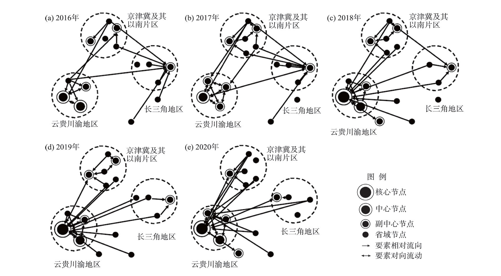
Virtual tourism flow (VTF) to some extent represents geographic biases of tourist demands. It is a crucial entry point for analyzing the spatial structure of China's tourism and promoting the formation of domestic circulation. From the perspective of VTF, this study built models of virtual tourism attraction and latent emissiveness using Baidu index search data from 2016 to 2020. Coefficient of variation and spatial autocorrelation were employed to analyze its spatial distribution characteristics. Virtual tourism dominance degree and correlation of each provincial node were analyzed to further investigate the characteristics of the spatial change of VTF network structure. The results show that: 1) Beijing, Shanghai, and Yunnan are the radiating centers in the spatial structure of China's VTF. Based on this, a virtual spatial structure with the core of the Beijing-Tianjin-Hebei region, the Yangtze River Delta region, and the Yunnan-Guizhou-Sichuan-Chongqing region is formed. 2) The polarization and diffusion features of VTF are manifested in the obvious diffusion effect of the Yangtze River Delta, and the significant polarization effect of the Beijing-Tianjin-Hebei region and areas to its south and the Yunnan-Guizhou-Sichuan-Chongqing region. Among them, the Beijing-Tianjin-Hebei region and areas to its south has changed from a dual core to a single core structure, while the Yunnan-Guizhou-Sichuan-Chongqing region has formed a robust regional circulation structure with multiple cores and multiple levels due to the region's continuously strengthened internal and external ties. 3) According to the spatial change of VTF network structure, intra-regional circulation is an effective way to balance the development of tourism within and outside a region. Meanwhile, provinces with strong virtual tourism advantage degree have stronger resilience, which can well boost the circulation of inter-regional tourism flow. 4) The change of VTF network structure is mainly affected by economic development level, tourism resource endowment, infrastructure development, and temporal and spatial proximity. This study broadens the horizon of tourism flow research by introducing the concept of VTF and analyzing both virtual tourism attraction and latent emissiveness. Its results provide a reference for the geographic direction of tourist demands, which can help to promote the coordinated regional development of tourism.
Building high-quality tourist clusters and creating multi-site scenic tour routes and loops are important breakthroughs in promoting the development of global tourism. Based on the data of "5A" scenic spots—the highest-level scenic spots—selected from 288 prefecture-level cities in China from 2006 to 2018, this study divided these sites into three categories: natural, humanistic, and comprehensive. With the help of ArcGIS and Stata, this study explored the spatial distribution characteristics of the "5A" scenic spots and quantitatively analyzed the impact and spatial effects of high-level scenic spots on tourism development of cities by using a dynamic spatial panel model. The study found that: First, "5A" scenic spots distribution showed spatial imbalance, agglomerated mainly in the eastern and central regions. Resource endowments differ great across regions, and the number of comprehensive scenic spots is seriously insufficient. Second, high-level scenic spots can significantly promote the development of tourism in cities, and have significant effects of spatial cooperation and spatial competition. Specifically, high-level scenic spots in adjacent cities of the same province have a spatial competitive effect on the cities' tourism development, and the main competition range is 0-400 km; while high-level scenic spots in adjacent cities across provinces have a spatial cooperation effect on the cities' tourism development, and the optimal cooperation range is 200-400 km. In the meantime, competition mainly occurs between the same type of scenic spots, and cooperation mainly occurs between different types of scenic spots. Finally, comparing the spatial distribution of scenic spots within each province, this study found that the scenic spots in the same province are mainly natural or humanistic "5A" scenic spots, which means that there may be competition between similar scenic spots within the same province due to their homogeneity. The conclusions of this research provide empirical evidence for the spatial allocation and spatial optimization of tourism resources.
This study examined the stable poverty alleviation of rural households from a sustainable livelihood perspective. It constructed an evaluation indicator system from five dimensions—natural capital, physical capital, social capital, human capital, and financial capital—and selected Tianzhu County in Guizhou Province, which is a deeply impoverished area, as the study area. Using the stable poverty alleviation index based on a sample of 1295 rural households, this study identified the influencing factors, explored the mechanism of influence, and proposed a long-term mechanism of stable poverty alleviation. The research results show that: 1) The overall level of the stable poverty alleviation index of rural households in the study area is relatively high, but although the stability of poverty alleviation is relatively strong, there are significant differences between individual rural households. The stability of poverty alleviation in the dimensions of physical capital, natural capital, and financial capital is relatively high, but the stability of poverty alleviation in the dimensions of human capital and social capital is low. In the case of the latter, households are at greater risk of returning to poverty. 2) Stable poverty alleviation index of most rural households in the study area can be categorized as general or stable type. The distribution of stable poverty alleviation households can be described as droplet shaped, with about 12.44% of the sample households in the critical category and at a high risk of falling back into poverty. 3) Skills training, proportion of migrant workers, land transfers, proportion of transfer income, distance to township centers, and distance to main roads are the main factors that affect the stable poverty alleviation of rural households in the study area. 4) A "five-in-one" long-term mechanism of facilitating industrial development, enhancing capacities, expanding employment opportunities, stimulating motivations, and improving infrastructure for stable poverty alleviation of rural households in deeply impoverished areas has been established, with the aim of improving the stability of poverty alleviation in rural households.
As the difficult and key point of rural revitalization, an accurate analysis of the foundation of rural revitalization and its influencing factors in out-of-poverty mountainous areas not only can provide a scientific basis for establishing an effective link between the consolidation of poverty alleviation and rural revitalization in the new era, but also provides important support for the formulation of policies related to high-quality development in mountainous areas. Based on the connotation of rural revitalization foundation, we constructed an evaluation indicator system of rural revitalization foundation and took the Longnan mountainous areas in the hinterland of the western Qinling Mountains as a case area to assess the foundation of rural revitalization and analyze the dominant factors that affect its spatial differentiation. The results show that: 1) The overall level of the foundation of rural revitalization in the Longnan mountainous areas in 2020 was low, with a mean value of 0.299. There were great differences in the level of rural revitalization foundation in different dimensions. Among them, the foundation of ecological livability was the best, the affluent life was the worst, and the foundation of rural revitalization in areas of different landform types varied greatly. 2) The overall distribution pattern of the foundation of rural revitalization was characterized by "low in the middle and high in the peripheries". The medium level areas account for the highest proportion, at 44.62%, roughly in a Chuan-shaped distribution, and the high level areas only account for 12.30%, mainly clustered in the eastern part of the Huicheng Basin. The different dimensions of revitalization foundation also showed obvious spatial differences. 3) Altitude, cultivated land per capita, the number of people employed in the agricultural sector, and total power of agricultural machinery all affected the spatial differentiation of the foundation of rural revitalization in the region. Among these key influencing factors, total power of agricultural machinery had the highest explanatory power, and its interaction with other factors significantly enhanced the explanatory power of spatial differentiation of the foundation of rural revitalization. The dominant factors of spatial differentiation of rural revitalization foundation in areas of different landform types varied widely.
Along with urban industrial upgrading and rural development, the return of floating population has become an important part of China's population movement. The returnees are becoming an important driver for rural revitalization and new-type urbanization. Distance is an important factor influencing population migration, but the impacts of distance on migrants' return-migration has not been understood well. Based on the data of China Migrant Population Dynamic Survey in 2016, a multi-proximity analysis framework and binary Logistic regression model were used to identify the role of distance in population return. The results show that: 1) Married people with older age and low-level of education, who have no advantage in the labor market, are the main part of returnees. They often have stronger return intention, as their families have a large emotional demand and dependence. 2) All the dimensions of proximity investigated in this study have significant impacts on the return intention of floating population. Geographical, institutional, and social proximities have a significant negative impact on return intention. People who migrated across provinces or dialects over a long-distance have a strong tendency to return. 3) The impact of multi-proximities on return intention showed heterogeneity in different groups. The return intention of highly educated migrants is restrained by the social security situation of their inflow places, at the same time, it is affected by dialect and geographical distance. The new generation floating population is more likely to choose to return under the influence of informal institutional proximity. The return intention of long-term migrants will be reduced when they become familiar with local language and actively participate in the social security system of the inflow places.
Reducing the inequality of food supply is an important way to achieve the goal of "zero hunger". This study examined the temporal and spatial evolution characteristics of global food production from 1986 to 2018 based on the Lorentz curve and Theil coefficient, and measured the global and regional food production inequality and the impact of trade. The results show that: 1) The production of all categories of food showed an increasing trend, and the output structure has changed significantly. The proportion of cereals in total food production has decreased, while the proportion of oils, vegetables, and fruits has increased. There were significant differences in food nutrition sources among different regions and countries, and the largest variance was observed at the country level. 2) The concentration degree of grain, sugar, and fruit production was relatively low, while vegetables, oil crops, roots and tubers, and aquatic product production was relatively concentrated in a few countries. The inequality of beans, vegetables, oil crops, sugars, and stimulants production per capita showed an increasing trend, while roots and tubers, fruits, livestock, and aquatic products production per capita showed a decreasing trend. The inequality of caloric output per capita was lower than that of fat and protein. 3) Trade played a significant role in reducing the inequality of global food supply, especially for sugars, oil crops, and stimulants, and the impact of trade is intensifying gradually. Thus, the formulation of nutrition-oriented food production and trade policies is of great significance for improving the equality of food supply.
Using mobile office is a new production and office activity in the information era. The development of mobile office is of great value to the digital transformation of office activities in big cities, the improvement of suburban office location, and the optimization and reorganization of urban and suburban office location. Based on the big data of mobile office app usage by users of China Unicom and enterprises in the urban and suburban areas of Wuhan City in 2019 and 2021, this research used conventional mathematical statistics, Getis-Ord Gi*, and hierarchical spatial clustering, as well as geographical detectors to explore the heterogeneity characteristics and trend of change of mobile office in Wuhan. The results show that: 1) From the perspective of the proportion of mobile office workers and average using duration, the suburbs are very close to the urban area, and the growth rate of mobile office usage in the suburbs is higher than that of the urban area, reflecting the flat development trend of mobile office. 2) From the perspective of spatial differentiation, the high value areas of the proportion of mobile office workers and mobile office average using duration in the suburban metro-cities are far more than those in the urban area. And in the surburban area, far more away from the urban area, the higher the most-value is, so is the degree of local agglomeration, indicating that mobile office has a good complementary effect on suburban office location. 3) From the point of view of industry type and size, the mobile office development level of producer and consumer services is higher in the urban area, while the mobile office development level of the information technology and manufacturing industry is higher in the suburban areas. In the urban area, the development level of mobile office is higher in the large-scale agglomeration centers with more enterprises, while in the suburban metro-cities, the development level of mobile office is higher in the small-scale agglomeration centers with fewer enterprises. This research contributes to clarify the spatial distribution characteristics of cities' mobile office activities in the mobile-information era, explore the mobile office development pattern of different industries, and optimize and reorganize the suburban office location. The method based on mobile office app usage using big data to analyze cities' mobile office activities also provides a new reference for probing city online activities.
Out-of-school hours care place (OSHCP) is a new type of educational auxiliary facility, mainly provides meals and rest places for primary and secondary school students, has gradually become the third activity space for students outside their homes and schools, and worth further examination from a spatial perspective. Based on the data of OSHCPs and related points of interest (POIs) in Yanta District of Xi'an City, we used spatial analysis, statistical analysis, and field investigation methods to explore the basic functions and location choice and its influencing factors of OSHCPs. The results indicate that: 1) The service demands of OSHCPs are from families with childcare needs in the lower grades of compulsory education for childcare assistance and children's "transfer" and "deposit", and the service types include student care, catering, help with homework, and so on. 2) The distribution of OSHCPs generally showed a trend of extending along the east-west direction, which is consistent with the urban morphology and the development status of residential committees, mainly in the traditional neighborhoods, high-rise housing estates, and work unit housing areas, concentrated in the low floors (1-5 floors). 3) Regional population, educational environment, investment costs, and spatial location influence the layout and location of OSHCPs, with the number and distribution of primary and secondary schools, the number and distribution of residential neighborhoods, and the distance from the central city having significant impacts. Finally, we summarized the influencing factors of location choice from three scales including urban area, residential committee, and care place in combination with the needs of the population, and provide an outlook on future research directions in conjunction with the "double reduction" education policy.
Through extensive and detailed field investigation inside and outside the Zoige Basin in eastern Tibet Plateau, a typical sedimentary profile containing the stratigraphic sequence of paleolake facies and paleo-riverbed floodplain facies was found in the front of the second terrace of the Yellow River in the Maqu section at the outlet of the Zoige Basin. Through grain size characteristic analysis and Optically Stimulated Luminescence(OSL) dating, we found that: 1) The pale-blue-grey paleolake sedimentary layer in the profile indicates that the lacustrine sediment formed in the deep-water anoxic environment, while the mottled pebble layer covered by the pale-yellow-orange lenticular sand layer was a typical fluvial floodplain sediment, which indicates the process of strong dynamic flow. The unconformable contact relationship between the two layers indicates that the profile is a typical sedimentary evidence for studying the Zoige Basin dissected by the Yellow River. 2) The OSL dating results of the top boundary of the pale-blue-gray paleolake sedimentary layer and the bottom boundary of the paleoshore-shallow lake sedimentary layer show that the Yellow River dissected the Zoige Basin at 37 ka BP, resulting in the leakage of lake water. At 35 ka BP, the lake water became shallow and disappeared, and then the Yellow River connected the water system of the Zoige Basin. 3) The strong neotectonic movement of the East Kunlun fault in late Pleistocene and the warm and humid climate of the Tibet Plateau in 37 ka resulted in the aggravation of the headward erosion of the paleo-Yellow River source in the rift valley grassland, and the Zoige Basin was dissected by the paleo-Yellow River from the west to the east in the Maqu bottleneck reach, resulting in the discharge of the paleolake water through the Yellow River, thus connecting the water system of the Zoige Basin and making it the source of the Yellow River. The study results have important scientific significance for an in-depth understanding of the evolution of river-lake water system and the formation of Yellow River water system in northeastern Tibet Plateau.
In recent years, "Holocene temperature conundrum" has received extensive attention from paleoclimatologists. In order to solve this conundrum, more Holocene temperature reconstruction needs to be carried out in different regions of the world. The Pamir region of Xinjiang, China, is located in the core area of inland Asia and many scholars have conducted in-depth studies on the Holocene climate change in this region. However, these studies are mainly focused on precipitation (or humidity) rather than temperature. In this study, the correlation between topsoil carbon isotopes and climatic factors (temperature and precipitation) was first established, and the results showed that δ13Corg in Pamir was highly positively correlated with temperature. Supported by the AMS 14C dating data of seven samples and 175 peat δ13Cα-cellulose data, the temperature variation in Pamir during the past ~5000 year was reconstructed. Generally, Pamir has shown a warming climate during late Holocene and the change can be further divided into two sub-stages: a fluctuating cool period from ~5000 cal a BP to ~3600 cal a BP and a fluctuating warming period since ~3600 cal a BP. The driving mechanism analysis shows that the temperature decrease before ~3600 cal a BP was mainly controlled by the decrease of summer solar radiation and the temperature increase since ~3600 cal a BP was mainly controlled by the enhanced radiative forcing of greenhouse gases and human activity.
Urban shrinkage is a new phenomenon in the process of China's rapid urbanization, which brings great impact and challenge to the traditional regional-urban planning cognitive theory and planning paradigm based on "growth scenario simulation". How to construct the theoretical and analytical framework of urban shrinkage research in China has become the focus of academia and planning management departments. The following issues were analyzed in the study: 1) Systematically reviewed the origin of the concept of urban shrinkage, the relationship between urban shrinkage and urban growth, urbanization, and its relationship with localization and internationalization. It pointed out that urban shrinkage and urban growth are the products of different process in two directions in the development of regional urbanization, also a product embedded in globalization and rooted in localization. It is necessary to avoid "discussing urban shrinkage based only on shrinking cities" in the study. 2) Distinguished and defined the concept and connotation of urban shrinkage and shrinking city. It pointed out that the inconsistency of current identification standards for shrinking cities stems from the confusion between the concept of shrinking city and urban shrinkage, the emphasis on the description of shrinkage concepts, and the negligence of the development correlation between factors and functions. 3) Conducted a preliminary study on the connotation of urban shrinkage research "sinicization" from the aspects of research scope, research period, definition standard, research background, and regional differences. It proposed to take the urban built-up area as the research scope and 10 years as the investigation period, use comprehensive indicators to replace single population indicator to construct the identification standard and method system of shrinking city, and use the analysis of the overall development environment of the city and its related areas and prediction of and response to the formation and development of shrinking city as the bases, to realize "sinicization". 4) Constructed a framework and path of shrinking city research in the Chinese context based on property right region, field theory, regional association, and regional difference. This study aimed to engage geographers in China for an in-depth discussion of the "sinicization" of urban shrinkage research, so as to provide Chinese experience for the study of urban shrinkage globally.
Territory is the key concept in political geography, and territorial trap is one of the most classical theories in political geography. This article systematically reviewed the literature on territorial traps, summarized the origin, development, and research progress of the territorial trap theory, and discussed its significance in Chinese political geographical studies. The theory of territorial trap proposed by Agnew is based on three geographical assumptions: the "trinity" of territory-state-sovereignty, the "dichotomy" of domestic-foreign, and the state as a social container. The territorial trap theory refutes the existing state-centric view of territory and emphasizes various effective forms of sovereignty besides the state's territory, such as extraterritorial sovereignty, graduated sovereignty, and social sovereignty. The extensive application of the territorial trap theory reflects its strong explanatory power in global governance, non-traditional security, cross-border migration control, cross-border resource protection, cross-border water politics, and so forth. This article argued that territorial issues should be understood from the complex interaction between territorial control and effective sovereignty and the perspectives from the center and periphery, and be examined by combining rationality and historical emotion. It has important implications for China to effectively resolve territorial issues, promote the realization of the Belt and Road Initiative, and establish the "community with a shared future for mankind".
This article critically reviewed the development of research perspectives in the studies of regional spatial structure, with an analytical shift from the focus of behavioral aggregation to behavioral interaction, as well as from place-based attributes to network-based interrelationships. Traditional spatial structure research mainly highlights social or spatial correlations among the attributes of intra-regional spatial units (for example, cities), based on the aggregated statistics of social and economic behaviors. Corresponding approach includes social-area analysis and homogenous-area detection. Recent studies have encountered a "relational turn” and "network turn", which aim to frame regional spatial structure into a combination of network structures and spatial patterns from the perspective of behavioral interaction and spatial network. Such network-based analyses include traditional functional-area analysis, community detection algorithms, and core-periphery analysis from the field of network science and social network analysis. By comparing these perspectives, this article finally suggested that future studies should further explore the rationale of behavioral interaction and intra-regional network in understanding regional spatial structure, avoid the trap of "methodological determination" by developing mesoscale analysis, and investigate multiple spatial structures across scales and mobility factors under the perspective of multilayer networks.
Mobility is ubiquitous and flourishing, and its impact on society, space, and individuals is becoming increasingly complex in the continuously changing sociotechnical environment of the contemporary world. Since the start of the "mobility turn", Western mobility studies and transport geography have experienced a fierce collision and gradually developed an extensive and in-depth dialogue, which have jointly promoted the inclusive development of mobility study in geography. However, the existing study on mobilities in geography in China has lagged behind, the research is mostly confined to the internal discourse system of sub-disciplines, and the mutually beneficial dialogue between disciplines has not been carried out effectively, which has not fully stimulated the research innovation in this interdisciplinary field. Therefore, in this article, we focused on the dialogue between Western new mobility study and transport geography and reviewed the key literature on mobility studies in the Western geographic research since 2006, which connects mobility study and transport geography in three common topics—mobility practice and meaning, mobility inequality, and information and communication technology and mobility. This article proposed a rethinking of mobility theory and its fruitful connotation, characteristics, and value, as well as outlining some avenues for future research where further conversation would continue in the area of daily mobility study, taking into account the current local context. We argued that the complementary and progressive nature of mobility research and transport geography constitute the premise of their dialogue, which also suggests that deepening the understanding of the multiplicity, relationality, and contextuality of the connotation of mobility, as well as integrating more dialectical thinking, will drive more innovation in mobility research. In the future, mobility research in China should further expand the multiple connotations of mobility, enrich the subjects and scales of research, think dialectically about the value of mobility, associate with sociotechnical contexts, and explore methodology innovations. Mobility study in the context of China could make great contributions to global research and promote the decentralization and further diversification of the international context.
Under the background of global climate change and complex international geopolitics, the spatial perspective of geography provides a new entry point for studying the nexus between energy, economy, and the environment. By summarizing the literature on energy-economy nexus, energy-environment nexus, and energy-economy-environment nexus, we found that: 1) There is a "spatial turn" in the research of energy-economy nexus, and location characteristics are used to explain spatial heterogeneity. 2) The literature on the energy-environment nexus focuses on the spatial effects of energy-related pollution and policies, and new research topics such as energy landscape research have emerged recently. 3) The study on the energy-economy-environment nexus has just appeared, with three general research frameworks: empirical research on causality, coupling and coordination degree evaluation, and multi-objective planning prediction. 4) The current research has shortcomings such as high homogeneity of empirical analysis, insufficient explanation of spatial disparity mechanism, and less research related to renewable energy. Accordingly, this article attempted to construct a research framework for the energy-economy-environment (3E) nexus from the spatial perspective. We also proposed further research topics based on the existing studies in China—improving the construction of the theoretical framework, strengthening renewable energy research, and carrying out simulation and prediction of energy-economy-environment systems under carbon reduction targets, so as to provide theoretical and empirical support for the realization of China's carbon peak and carbon neutrality goals.
Zhang Xiangwen was a pioneer geographer in modern China. In the turbulent period of the late Qing Dynasty and the early Republic of China, he combined his academic pursuit with patriotism, and sought to serve the nation through geoscience discipline in the midst of his changing identities. His primary social identity as a geographer was intertwined with multiple identities such as revolutionist, historian, educator, and industrialist. Zhang Xiangwen's academic contributions include leading the establishment of the China Geoscience Society, which was the predecessor of the Geographical Society of China; the founding of the Journal of Geosciences, which was the first Chinese academic journal of geography; the proposal of the Qinling-Huaihe north-south geographical boundary; the creation and compilation of geography textbooks; and the active engagements in flood control research and field research. This article attempted to tease out Zhang Xiangwen's main activities, academic thoughts, and their practical implications by extensive data comparison. It is argued that open mindedness and professionalism, outstanding organizational leadership, and active participation in solving practical and societal issues led to Zhang Xiangwen's pioneering work, which still has significance for the development of geographers and academic community nowadays.