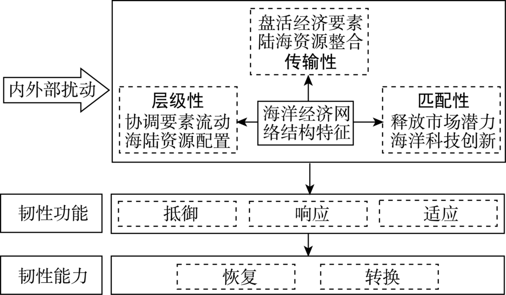
With the continuous improvement of the strategic status of China's marine economy, enhancing the resilience of marine economy in China's coastal areas under internal and external disturbances has become an inevitable way and an important guarantee for its development. In this study, we carried out resilience research from the perspective of marine economic network structure. We used the data of sea-related A-share listed companies and their subsidiaries to build a marine economic network, and evaluated the structural resilience of the marine economic network in 2010, 2015 and 2020 from the three dimensions of hierarchy, assortativity, and transmission. The results show that: 1) The hierarchical structure of the marine economic network in China's coastal areas has been enhanced, and regional absolute polarization and relative equilibrium coexist. 2) Assortativity has changed to disassortativity, and the connection between core cities and peripheral cities has been strengthened. 3) Transmission is generally at a low level but has the tendency to improve. 4) The enhancement of hierarchical structure, disassortativity, and transmission has improved the cohesion, innovation, and openness of the marine economic network, which increased the structural resilience of the marine economic network in China's coastal areas. This study aimed to enrich the resilience research in economic geography and provide some basis and reference for the safe development of the marine economy, in order to facilitate the high-quality development of marine economy in China.
With the increasing economic interaction between cities, disturbance of economic risks has a great impact on their economic resilience. Examining urban economic resilience is crucial for the economic development of cities. Using economic risk disturbances of the Asian financial crisis and the global financial crisis as examples, this study measured economic resilience from four dimensions, including relative-diversity index, relative-specialization index, regional economic connection intensity, and regional economic sensitivity, and analyzed the characteristics and change of the spatial and temporal patterns for cities in the Yangtze River Delta urban agglomeration and their causes. The results show that: 1) The relative-diversity index of most cities declined from 1997 to 2016. The relative specialization developed stably, which promoted the regional industrial division and the improvement of economic resilience. Some of the cities in Anhui Province exhibited structural homogeneity in manufacturing industries. 2) The relative-specialization index showed significant regional differences, which was correlated with dominant industrial structure. The relative-specialization index of the eastern cities was medium, while the western cities mainly developed resource-based economy with high specialization. In the face of economic risk disturbances, some cities in the region tended to strengthen the traditional low-efficiency industry model. These cities had low regional coordination ability, which negatively affected economic resilience and high-quality development. 3) The proportion of total connection between a core city and other cities in the Yangtze River Delta urban agglomeration decreased year by year, and the agglomeration ability of core cities is still strong, hindering the systematic development of economic resilience. Shanghai was one of the highest regional economic connection intensity cities with its large economic volume, multiple industrial types, and large population, leading to the increasing regional economic gap in the Yangtze River Delta urban agglomeration. Spatially, the regional economic connection intensity between eastern cities was higher than that of western cities. 4) The resistance and recoverability of cities in the urban agglomeration were closely related to their economic development models. Export-oriented cities were the first to be seriously affected by economic risk disturbances and had low resistance in the period of urban economic contraction. However, the cities with high-tech industries and domestic demand industries developed rapidly in the period of urban economic expansion. Economic risk disturbances had regional sequential influence on the economic growth of different cities. This paper is helpful to remedy the deficiency of the existing literature on urban economic resilience from the perspective of urban agglomeration, and provides methodological guidance for the high-quality and sustainable development of urban and regional economies in China.
Hierarchical structure identification is important for the construction of national park groups. However, existing studies have paid little attention to the method for the identification of hierarchical structure of national park groups. This study proposed the UBAN framework (Uniqueness, Biodiversity, Aesthetic value, Naturalness) for the identification of park hierarchy in national park groups through theoretical analysis and multi-criteria analysis methods, and applied the framework to the Qinghai-Tibet Plateau National Park Group for testing its feasibility and validation. The results show that the UBAN framework is feasible and easy to operationalize in identifying hierarchical structure of the national park group. Among the 21 national parks, the Source of the Yangtze River has the highest relative importance, followed by Mount Everest and Giant Pandas. The large difference in relative importance within the national park group is attributed to differences in various dimensions. When the four-level structure is adopted, the overall difference is mainly caused by the differences between the levels rather than the differences within each level, suggesting that the four-level structure is suitable for national park group management based on the characteristics of each level. In the four-level structure, the first level includes the Source of the Yangtze River, Mount Everest, Giant Pandas, Selincuo-Puruogangri, and the Source of the Yellow River. Parks at this level have the highest ecosystem uniqueness, biodiversity, aesthetic value, and naturalness, and plays a central role in the construction of the Qinghai-Tibet Plateau National Park Group. The second-level includes Pamirs, Brahmaputra Grand Canyon, Sacred Mountain and Holy Lake, Qilian Mountains, the Source of the Lancang River, and Kunlun Mountains-Hoh Xil. Parks at this level have high ecosystem uniqueness, biodiversity, aesthetic value, and naturalness, and should be further optimized in the construction of the Qinghai-Tibet Plateau National Park Group. The third-level includes Pudacuo, Daocheng Yading, Ruoergai, and Zanda Earth Forest. Parks at this level have moderate ecosystem uniqueness and biodiversity, and should be characteristically developed in the construction of the Qinghai-Tibet Plateau National Park Group. The fourth-level includes Yadan, Gongga Mountain, West Tianshan, Dulong River-Three Parallel Rivers, Zari Mountain, and Haixi Salt Lake. Parks at this level have lower ecosystem uniqueness, biodiversity, aesthetic value, and naturalness, and should be given significant supports in the construction of the Qinghai-Tibet Plateau National Park Group. This study contributes to the national park group structure theory and offers implications for the construction practices of national park groups.
Limited by the difficulty of obtaining individual mobility data, existing studies on population mobility mostly used strength of traffic flow to simulate population flow between cities, while ignoring the differences between them. This study constructed transportation networks based on inter-city bus and train trips in Northeast China, and built population flow networks based on Tencent location big data correspondingly. It then analyzed the differences and relationship between the two types of networks by using social network analysis and quadratic assignment procedure model. The results are as follows: 1) Both railway population network and railway transportation network in Northeast China are characterized by a spatial pattern of dense in the south and sparse in the north and numerous in the east and fewer in the west, with the Harbin-Dalian corridor as the axis. The spatial structure of railway population flow is more dispersed, while the polarization effect of railway transportation network is obvious. 2) There are great differences between road population flow network and road transportation network. There is not only competition but also complementary relationship between roads and railways. That is, road population or transportation flow is often strong in areas with less developed railways. 3) The accuracy of simulating inter-city population flow with a single transportation network is low, while the composite influencing factors can more accurately express the inter-city population flow structure. Among other influencing factors, economic ties and population size do not have significant impact on population flow, while adjacency between cities has a significant impact on the structure of population flow. 4) The fitting regression between railway population flow strength and its transportation network is better than that of roads. This study quantitatively explained the correlation between population flow and its transportation network, which provides a theoretical and practical reference for the simulation of population flow in transportation network.
The growth and contraction of small towns have attracted great attention in the process of regional transformation. However, the criteria for distinguishing growth and contraction of small towns lack clarity, and the research on transformation mechanism is relatively limited. Therefore, this study proposed a criterion for identifying the types of growth and contraction for small towns based on statistical data and NPP/VIIRS series remote sensing data. It established a heuristic analytical framework to analyze the driving forces, results, and responses for demographic and economic transitions in 5268 small towns in the Yellow River Basin. The results show that growth and contraction of population and economy coexist for small towns. Small towns with population reduction are mainly concentrated in the "Jiziwan" areas, while small towns with economic contraction are mainly located in the upper and middle reaches of the Yellow River Basin. The Guanzhong, Zhongyuan, and Shandong Peninsula urban agglomerations are the core areas with population and economic growth. The small towns can be divided into four types according to their population and economic change: sustained growth (6.4%), transitional growth (5.8%), slow growth (42.4%), and sustained contraction (45.4%). The small towns in technology-intensive and labor-intensive cities showed obvious growth trend, while contracting small towns accounted for a large proportion of resource-oriented cities. Multiple thresholds of natural conditions indicate that small towns in both plain and high-altitude areas have growth advantages. Scale economies and location advantage can promote the growth of small towns as a whole, but trickle-down effect and externality will cause the contraction of some small towns. Hence, small towns with different growth and contraction types should explore various transformation paths according to the local conditions.
Farmyard functional change is a dominant expression of rural functional transformation in tourism villages. It is of great significance to explore the spatial-temporal change characteristics and influencing factors of farmyard functional transformation to promote sustainable regional development. Taking Lianhuachi Village, a rural tourist resort in Huairou District of Beijing, as a case and using semistructured interview, GIS tools, and remote sensing images, this study examined the functional transformation process of 149 farmyards of the village during 2000-2020, and analyzed the functional transformation characteristics and influencing factors of such rural tourist villages under the background of industrial and commercial capital inflow to the countryside. The results show that: 1) The farmyards switched from residential function to tourism and productive functions repeatedly. The business forms of tourism changed from diversification to uniform. 2) The spatial differentiation of farmyard functions reflects the differences in investment intensity and management modes, and the advantages or disadvantages of a location are relative depending tourism forms. 3) The changes of farmyard functions were accompanied by the replacement of users, and outsiders played a significant role in promoting the upgrading of farmyard functions. 4) The impacts of government policies and internal and external capital inputs on the transformation of farmyard functions have phased characteristics, which in different periods can be primary or secondary, strong or weak, and obvious or implicit. The main driving factors of farmyard functional change in Lianhuachi Village can be identified in three stages: the joint actions of external capital and government policies, the dominance of government regulation, and government control and the competition of external and internal capitals. As a result, the farmers acted from active participation to passive compliance, and finally were forced to withdraw from the tourism business.
Health hazards and risks caused by air pollution have become a public topic. Ecological civilization construction and "Healthy China" strategy emphasize the alleviation of environmental stressors and the construction of healthy living environment. Using city-level data of population census and the 1% provincial sample demographic survey from 2000 to 2015, this study examined the spatial-temporal patterns of mortality and the effects of PM2.5 concentration on mortality based on spatial regression models. It further examined the moderation effects of regional socioeconomic conditions on the PM2.5 concentration-mortality association. Analytical results are as follows: 1) There is a considerable regional variation in mortality rate in China. Cities with high mortality rates initially were maincdly concentrated in Southwest China, and they become increasingly concentrated in Southwest China, North China, East China, and Central China after 2005. Cities with low mortality rates have long been concentrated in Northwest China, Northeast China, the Yangtze River Delta, the Pearl River Delta, and Beijing and Tianjin. 2) There is a significant spatial correlation in mortality rates. From 2000 to 2015, mortality rates became increasingly concentrated in particular regions. High-high type areas were concentrated in the southwest in the early stage and then expanded to the east. Low-low type areas are mainly distributed in the north of Xinjiang, the west of Inner Mongolia, and Guangdong Province and its surrounding areas. 3) The concentration of PM2.5 has a positive correlation with mortality rates and a significant spatial spillover effect on mortality rates in neighboring areas. 4) The impact of PM2.5 on mortality is subject to the influences of educational differences and urban-rural divides: regions with great concentration of highly educated people are less vulnerable to PM2.5 health impact, and areas with a low level of urbanization are more subject to health risks of PM2.5. The results show that regional prevention and control of air pollution is important, and in order to reduce health risks, more attention should be paid to the development of high-quality urbanization, optimization of economic structure, and promotion of residents' health literacy. Our findings can provide a scientific reference for the environmental risk assessment of air pollution and the construction of healthy living environments.
To unravel the conditions of application of street eyes theory and defensible space theory as well as the reasons of their theoretical dispute, this study took the central urban area of Beijing as research area and systematically explored the impacts of the permeable built environment on theft crime and the moderation effects of social disorganization on such relationships by integrating crime opportunity theory and social ecology theory. Big data from multiple sources during 2016 to 2020, including court records, location-based service data, street view images, points of interest, and road networks were used together. The results indicate that characteristics of permeable built environment such as land use density, mixing degree of urban functions, road network density, and transparency of street buildings all have positive and significant associations with the density of theft crimes in general. Furthermore, the direction and intensity of incluence of built environment features on criminal activities vary depending on the social ecological factors of communities. In other words, the degrees of social disorganization moderate the links between permeable environment and theft distribution. With social disorganization exacerbating, including the increase in residential instability, visitor mobility, employee mobility, population heterogeneity, and socioeconomic disadvantages, the positive effects of permeable built environment on crime will be steadily magnified, which more conforms to the defensible space theory. On the contrary, street eyes theory has better explanatory power in communities with stable social structure and abundant social capital where street eyes can be activated so as to provide effective informal surveillance to ensure safety. Unfortunately, according to the critical value of moderators estimated by the regression models, the later situation is less common in Beijing, suggesting that defensible space theory is more applicable in the majority of communities and the safety risks would increase when applying the approach of New Urbanism.
Employment distribution is one of the key components of urban structure. Employment polycentricity is currently becoming a global phenomenon, leading the paradigm change of urban structure research around the world. However, this topic is covered by relatively few studies in China. Therefore, by browsing a large number of relevant publications, this article presented its research progress in order to provide a reference for studies on employment polycentricity in China. First, this article briefly introduced the geographical patterns and process of urban employment concentration/decentralization and polycentricity, focusing on reviewing the current consensus and debates, as well as dynamics and growth trends of employment centers. Second, it traced the mechanism of urban employment decentralization and its evolving polycentric patterns from different theoretical perspectives, with particular attention to the predominant forces on the formation of polycentricity through the lens of spatial political economy, especially interactions between the institutional factors of urban planning and governance and the market. Finally, the article summarized the consequences of employment polycentricity from two aspects: the impact on urban spatial features and on urban commuting. The evolution of urban employment polycentricity provides a unique view for us to understand the growth logic of urban space, which is significant for the policy making of urban transformation and spatial reconstruction of Chinese cities.
The impact of smart technology has penetrated into various aspects of city life. The flow of spatial elements is faster and more complex. Urban functions need to be adjusted to adapt to the changes of residents' activities. The smart operation and management of urban space has also become a new challenge. This article reviewed the impact of current smart technology on urban space from three aspects: urban spatial element organization, residents' activities, and spatial functions, and spatial operation and management. Looking forward, we believe that urban space would have the characteristics of instantaneous relocation, spatial intelligence, complex mobility, and stronger resilience in the next five to ten years. To provide guidance for urban space research and planning design under the influence of smart technology, this article further proposed four key directions of future urban space research: urban space organization, functional form, operation management, and planning methods.
Since the rise of geomedia in recent years, the previous boundaries between production and consumption, and between technical object and symbolic representation in urban public space and everyday life space are increasingly blurred, leading to the need for theoretical innovation in terms of the "virtual/physical" dualism in geography. The development of geographies of media and communication, which is the outcome of the "spatial turn" of media research and the "communication turn" of geography, contains the potential to break through the dualism. This article reviewed the core concepts, main issues, and research framework of geographies of media and communication in order to promote the academic dialogue between Chinese scholars in geography and media and communication studies, as well as to expand the research field of Chinese human geography. First, geographies of media and communication in Western geography was founded on the dynamic relational notions of media and space that were deeply influenced by postmodernism and posthumanism thoughts, including core concepts such as texture, mobility, materiality, and embodiment. Second, existing studies mainly focus on the spatiality of digital media and posthumanism media, the hybrid space politics dominated by digital media representation and algorithmic logic, as well as the hybrid space experience brought by mobile media. Finally, this article referred to the "thirdspace" as a potential direction for geographies of media and communication to surpass the previous dualism, and materiality and embodiment serve as the ontological bridge between media and space.
Maps are the basic language of geography and an indispensable tool for spatial analysis. But maps have long been seen as an objective, neutral scientific product. Inspired by critical geography, critical cartography/GIS emerged with the goal of elucidating the nature of discourse, power relations, and even the physical environment embedded in cartographic practice and challenging the untested but taken for granted assumptions in cartographic representation. After nearly 40 years of debates, this field of research has been gradually defined, and a blueprint of "hybrid geographies" has gradually emerged. Through the combination of various geographical methodologies, critical cartography/GIS has generally formed two research directions. The deconstruction approaches mainly start from the identity of cartographers and the production process of map knowledge, and analyze the inseparable relationship between "cartographicality" and national governance as well as the inherent mechanism of power. The construction approaches mainly explore the new production and representation of maps by means of collaborative mapping and counter-mapping. The research of critical cartography/GIS in China has just started, so it is necessary to continue to draw on the achievements of critical geography to carry out the deconstruction research of different types of maps in different historical periods, strengthen the convergence of construction path and deconstruction path, and actively participate in the social applications of research results.
As the world's geopolitical game center of gravity shifts to the Asia-Pacific region, China's periphery and the areas along the Belt and Road will be the areas where shatter belts are most likely to occur, facing huge geopolitical risks. In this article, we traced the origin of the concept of shatter belt, reviewed the relevant research progress of shatter belt, and proposed the future research direction of shatter belt in China. "Shatter belt" was introduced from geology to geopolitical research in the early 20th century and was mainly used to analyze and explain the influence of geographic configurations on conflicts. Research on shatter belt mainly focused on the interpretation of its basic characteristics, analysis of the distribution and evolution of shatter belts, and exploration of the integration paths of shatter belts. The research methods were mostly qualitative analysis and description. The research of shatter belt was mainly concentrated on periods of dramatic changes in the global geopolitical situation and the Eurasian rimland. Future directions of shatter belt research in China should include: 1) constructing a theoretical analysis framework of shatter belt, and strengthening the visualization, quantification, and simulation of shatter belt by combining big data and other analytical methods; 2) strengthening the examination of the evolution processes and driving mechanisms of shatter belts in China's peripheral regions and along the Belt and Road, and identifying and assessing the geopolitical risks in shatter belts; and 3) exploring the ways to integrate shatter belts by combining the thought of a community with shared future for mankind.
The transformation and development of urban waterfront space is the key way to promote the optimization of urban space and the adjustment of industrial structure, which has become the main part of the current international urban renewal and redevelopment efforts, and a large number of relevant studies have emerged. Therefore, it is necessary to summarize the existing studies. Taking the relevant publications in the Web of Science and Science Direct databases from 1988 to 2020 as the analysis object, this study systematically examined the research results of the transformation and development of urban waterfront space abroad, summarized and analyzed the research contents and main conclusions from the aspects of the transformation process, mode, motivation and mechanism, and effect. The results show that international studies on the transformation and development of waterfront space mostly used qualitative methods to carry out descriptive analysis of cases, the research themes have shifted from paying attention to practical needs to exploring underlying academic issues and gradually diversified, and the research perspective increasingly emphasizes humanism and the concept of equality. Finally, considering the international research experience and domestic reality, this study proposed that in the future, China should change the research perspective and research object, pay attention to the comparative study of multiple cases in different regions, reveal the transformation process of urban waterfront space, simulate the transformation mechanism of urban waterfront space, and comprehensively evaluate the transformation effect of urban waterfront space, so as to optimize and improve the research system of urban waterfront space in China.
Since the start of operation of the China-Europe Railway Express (CR Express) in 2011, with its increasing domestic and international influences, it has become one of the hotspots of academic research in China. Based on the data from the China National Knowledge Infrastructure (CNKI) database, the number of publications related to the CR Express has increased by about 70% annually, but the proportion of those published in highly cited journals is still relatively low. From the geographical perspective, the research on the CR Express by Chinese scholars mainly focuses on four aspects: 1) estimation of its regional scope with competitive advantages; 2) analysis of competition among the operating regions; 3) optimization of the spatial layout of its transportation network; and 4) analysis of its regional impacts and differences. The shortcomings of the current research mainly include that theoretical research has not yet followed the practice; the research on the overall reform of the CR Express is still lacking; and the research is still limited to the national territory. Therefore, future research on the CR Express should accelerate the theoretical framework construction, produce more systematic and targeted countermeasure recommendations, and deepen the exploration at a larger spatial scale.