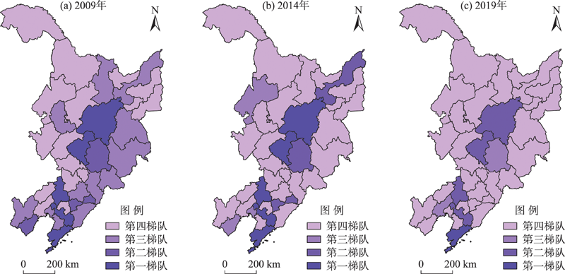
Strategic emerging industries are important support for national economic development. It is of great significance to explore the spatial-temporal evolution characteristics and influencing factors of the development level of related industries in Northeast China to promote regional economy and industrial innovation development. Using the Tianyancha software to extract the A-shares and the new over-the-counter market listed company data in 2009, 2014, and 2019 for Liaoning, Jilin, and Heilongjiang provinces and applying the methods of Markov chain, spatial autocorrelation analysis, and geographical detector model, this study explored the spatial and temporal change of strategic emerging industry development level and analyzed its influencing factors. The results show that: 1) The development level of strategic emerging industries in Northeast China is constantly improving, and the growth rate is slowing down. All types of strategic emerging industries in Northeast China have achieved leap-forward development, while the industries at a high development level have achieved steady development. 2) The development level of strategic emerging industries in Northeast China is characterized by a "polar area" in the central part of the region and a "S-shaped polar zone" in the south. Spatial agglomeration is weakened, and the spatial differentiation of the provinces is gradually enhanced. The spatial centers of gravity of development level of various industries have shifted southward, with both diffusion and agglomeration effects. 3) Different factors play different roles, and multiple factors jointly affect the change of the development level and spatial pattern of strategic emerging industries in Northeast China.
In the development of science and technology innovation centers, upgrading to complex technologies requires full consideration of the local technology capacities. Evolutionary economic geography emphasizes the impact of technology relatedness with the local technology capacities on technology evolution. This study took three international science and technology innovation center cities, Beijing, Shanghai and Shenzhen, as examples, and incorporated complexity and relatedness into the research framework to comparatively analyze the technology relatedness and complexity of the three cities and their impact on technological change. It is found that there are significant differences in technology structure, technology relatedness, complexity, and evolutionary paths among the three cities. Shanghai has higher technology relatedness and lower complexity, Shenzhen has the lowest technology relatedness and highest technology complexity, and Beijing is in between. In terms of evolutionary trends, Beijing has experienced an obvious change to complex technologies; Shenzhen has the largest increase in overall technological complexity, but after 2006 there was a trend toward diversification into low-complexity technologies; and Shanghai has the smallest increase in technological complexity. The econometric analysis shows that technologies with stronger local technology linkages are more likely to become the dominant technologies in the next stage of development in the three cities, but technologies with high complexity are more likely to become the dominant technologies in the next stage of development in Beijing, and have no significant impact on the technology change of Shanghai and Shenzhen. The construction of science and technology innovation centers requires cities to fully consider urban technology base and evolutionary characteristics, and formulate targeted technology development strategies.
In the context of the development of regional economic integration, urban network research based on different financial industries has gradually become a research hotspot in financial geography. Using the data of 15524 financial companies in the Yangtze River Delta region from 1990 to 2017 and the interlocking network model, modularity, and QAP (quadratic assignment procedure) regression model, this study explored the organizational models and influencing factors of the urban network in the Yangtze River Delta over 27 years. The study found that: 1) From the perspective of the banking industry, the urban network presents a fan-shaped pattern with Shanghai as the core and radiating to cities such as Nanjing, Hangzhou, and Ningbo. From the perspective of the insurance industry, the multi-centric network pattern with Shanghai as the core and Nanjing, Hangzhou, Hefei, and other cities as the sub-centers is more prominent. From the perspective of the securities industry, the urban network connection pattern is relatively stable. 2) Based on different financial industries, urban networks have obvious characteristics of "small world" and scale-free networks. Geographic proximity and preferential links are important factors that affect the division of network "factions". 3) Core cities such as Shanghai, Nanjing, Hangzhou, and Hefei have strong network radiation and agglomeration capabilities and play the "gatekeeper" role in the overall network connection. However, due to the relatively small number of securities companies and slow expansion speed, their network radiation and agglomeration ability is far lower than that of banking and insurance networks. 4) The per capita GDP difference has an inverted U-shaped relationship with the banking network. Cities within the same administrative division and with geographic proximity can reduce spatial friction and promote the flow of factors. Cities with a similar industrial structure and financial environment can help release the lock-in effect, thereby accelerating the integration of actors into the external network.
Many rural heritage sites in China are rich in natural and cultural tourism resources. The co-creation of landscape resources, co-ownership of territorial space, and diverse ethnicities and rural social relationship provide the basis and conditions for the symbiosis development of tourism. In addition, as an open system with comprehensive multidimensional and dynamic evolution, rural heritage sites are formed by the interaction of various elements. Population, land, and industry are the core elements of rural development. Symbiosis theory is an important theory for studying the internal relationships of rural systems, which can be used to analyze the coordinated development paths of human-land-industry subsystems in rural heritage sites. Taking Tingsong cultural community in Yi County, Hebei Province as an example, this study examined the collaborative dynamic evolution process of the three subsystems of population, land, and industry driven by the returning elite from the perspective of symbiosis, and put forward the symbiotic paths of rural development: 1) Building the symbiont of rural community. 2) Promoting the regional circular economic and ecological sphere. 3) Cultivating the horizontal symbiotic chain of industries. The results of this study may provide some reference for the comprehensive revitalization of population, land, and industry in rural heritage sites.
Integrated rural tourism aims at realizing the sustainable development of rural areas, and improving the integration of rural tourism is of far-reaching significance for rural revitalization and sustainable tourism. Based on the Western framework of integrated rural tourism research and combined with existing research and the development of rural areas in China, this study constructed a rural tourism integration evaluation indicator system composed of 29 indicators covering 6 dimensions of network, scale, empowerment, endogeneity, embeddedness, and complementarity. Using the ArcGIS spatial visualization tool, geographically weighted regression analysis, and geographical detectors, this study analyzed the spatial differentiation characteristics of rural tourism integration level and influencing factors in Qianshan City of the Dabie Mountains. The results show that: 1) There are obvious spatial differences in the level of rural tourism integration in Qianshan City. The level of rural tourism integration in the southern part of the city is significantly higher than that in the northern part. There is great potential for the improvement of rural tourism integration in the sample villages. 2) The development of rural tourism is weakly linked to the "beautiful countryside" program, and the phenomenon of "beautiful hollow villages" is a key barrier to enhancing rural tourism integration in the city. 3) Tourism development stage, resource support type, and rural economic development level are the dominant factors that influence the spatial differentiation of the level of rural tourism integration in Qianshan City. Interactions between the influencing factors enhance the spatial differentiation of rural tourism integration. Integrated rural tourism is a tourism development model that realizes value co-creation and comprehensive benefits. The results of this research may provide some theoretical guidance and practical reference for the high-quality development of rural tourism, and promote the improvement and development of integrated rural tourism theory.
Since the Ministry of Education of China issued a series of documents requiring the implementation of the policy of nearby enrollment without entrance exam in 2014 and 2015, the enrollment qualifications of public primary and secondary schools have been linked to housing property. In this context, it is of significant value to explore how the primary and secondary school education resources affect housing prices and how the resulting urban socio-spatial restructuring takes place. Based on the data from open platforms of Anjuke, Lianjia, and Baidu and survey questionnaire and interview data, this study took Wuchang District of Wuhan City as the case area to explore the real influence of school districts on housing prices through adopting the hedonic price model, geographically weighted regression (GWR) model, and other technical methods. Moreover, starting with the concept of "production of space", this study explored the effect of school districts on urban socio-spatial restructuring. The results show that: 1) The impact of the characteristics of school districts on housing prices has exceeded the traditional housing characteristics, such as location, architecture, and neighborhood. 2) Housing within the high school district provides a convenient path for capital inflow from secondary to tertiary circuits, forming a macro basis for the production of school districts as well as a new stratification of social space. 3) At the micro scale, the competition for high-quality school districts has produced "people of school districts" and "space of school districts", and then enclaves of school districts have emerged, which has an impact on the traditional urban social space. 4) Unlike the "danwei (workplace) people" and "community people", the definition of "people of school districts" does not mainly rely on occupational or income divisions, but is associated with families of similar life cycles.
Urban park green space (UPGS) is an important part of the urban ecosystem. Good accessibility of UPGS can promote urban livability and improve residents' well-being. It is important to evaluate the fairness of UPGS accessibility. Taking the central city of Wuhan as a study case and 2020 as the research time period, this study measured the accessibility from the supply and demand aspects, evaluated the spatial characteristics of the accessibility of UPGS from both the local and global perspectives, and further explored the relationship between accessibility and residents' social and economic conditions, in order to explore its social equity. Our findings include: 1) The spatial distribution of accessibility of regional, city, and comprehensive level UPGS is better than that of community level UPGS. 2) The spatial pattern of the overall accessibility of UPGS in the central city area of Wuhan gradually decreases from the core to the periphery. The communities with more UPGS and higher UPGS density show a higher level of accessibility. 3) There is a positive spatial correlation between UPGS accessibility and residents' socioeconomic conditions. The communities with higher housing prices also have higher UPGS accessibility. Thereby we identified marked social inequality in terms of the UPGS accessibility for Wuhan. It is recommended that in the future we should be further concerned with the optimization and regulation of the layout of UPGS with more nuance. While implementing the universal strategies, we should adopt targeted strategies and implement precise policies for the needs of different regions and different social groups. This study contributes to the literature in several ways. Using multi-source data and new technology to optimize indicators and data sources, the quality of parks was measured from UPGS area, ecosystem service value (ESV), recreation facilities, and safety conditions and various traffic patterns, real-time conditions, and selection preferences of different age groups, and so on were considered. At the same time, this study paid attention to the social inequality of accessibility, which enriches the empirical content and case materials and provides a scientific basis for the layout of urban infrastructure and the practice of environmental justice.
Allocation of public medical facilities affects the health and well-being of urban and rural residents, therefore a scientific and accurate estimation of equal accessibility of public medical facilities in rural areas is of great significance. In rural areas, the population is scattered and the scale of settlement is small, and the medical care demand of residents is different from that of urban residents. The 2-step floating catchment area (2SFCA) and 3-step floating catchment area (3SFCA) algorithms are unable to accurately reflect the pattern of population distribution in rural areas, the characteristics of medical care-related travels, and residents' preference for higher-level medical institutions. Therefore, the 3SFCA method is not effective in evaluating the accessibility of medical facilities in rural areas. This study improved the 3SFCA algorithm from three aspects—selecting the distance attenuation function according to the travel pattern of the rural residents in Haikou City, gridding the study area into population demand points, and considering the attraction of medical institutions of different levels to residents. Then the methodological framework for evaluating the accessibility and spatial equality of public medical facilities in rural areas was established, and an empirical analysis of Haikou City was conducted. The results show that: 1) The improved 3SFCA algorithm can accurately evaluate spatial accessibility at a finer grid, and the established rural medical facility accessibility and spatial equality evaluation model is more objective. 2) The accessibility of public medical facilities in the rural areas of Haikou City is poor, and the spatial differences are obvious. The high-value areas are distributed in the east of the study area, such as Sanjiang, Yunlong, and Jiazi towns, and the low-value areas are mainly concentrated in the west of the study area. 3) The spatial equality of the allocation of public medical facilities in the rural areas of Haikou City is also poor. A small number of areas of high and medium-high equality level are located in the low- and medium-density areas, while the areas of low and very low spatial equality level cover a large number of high-density areas, and the spatial equality of medical resource allocation urgently needs to be improved.
Public transport is of great significance for maintaining the quality of life of the elderly population. Based on frequency differentiation, this study took the urban area of Wuhu City as the research area and used the Thiessen polygon of bus stations as the spatial unit and smart card data of four months in 2018 to analyze the activity space of the elderly. Based on the identification of the locations of elderly bus card swiping, this study calculated the residential area of the elderly and the bus activity points of different activity frequencies and used the standard deviation ellipse to represent the activity space, and selected the radius and direction as the measurement indicators.The global linear regression analysis model was used to compare and analyze the difference in the impact of the built environment on daily and occasional activity spaces. Furthermore, the geographically weighted regression model was used to analyze the spatial heterogeneity of the impact of built environment factors. The main findings of the study are as follows: 1) The daily and occasional public transport activities of the elderly present similiar typical zonal distribution characteristics, but the specific zonal hierarchical structure and coverage are different. Occasional activities have a more obvious attenuation level from the city center to the periphery, while daily activities are relatively even. 2) There are differences in the mechanism of influence of daily and occasional activity spaces, and the intensity and direction of influence of the built environment in different spaces are clearly different, especially in the outer parts of the city. More factors in the built environment affect daily activities, the intensities of influence are relatively homogeneous; there are clear differences in the coefficient level of the influencing factors of occasional activities. The research results show that in the planning of the layout of urban public transport and public service facilities, it is necessary to consider the regular daily activities of the elderly to meet their high-frequency and basic life needs, as well as their occasional and low-intensity activity requirements. Establishing a structured and heterogeneous public service facility layout system for different spaces in the city can solve the problems of existing public transportation and public service facilities that do not consider the needs of the elderly, which can help provide improved urban services for the elderly.
In the context of mobility, due to the collision between the home culture gene and local food culture, immigrant groups inevitably fall into the dilemma of maintaining the home dietary tradition and integrating into the local food culture, which leads to problems such as dietary adjustment and identity anxiety. Although scholars have discussed the adjustment strategies of floating population groups under the influence of different food cultures, most of them regard the relationship between adhering to the home dietary tradition and accepting the local food culture as a kind of opposition, ignoring the negotiation process of individual initiatives. From the perspective of cultural geography, this study took the immigrant group in Guangzhou City as the research object and analyzed the multiple strategies and identity negotiation adopted by them in the process of trans-local dietary adaptation. It was found that under the influence of different local dietary cultures, the strategies of trans-local dietary adaptation of floating population groups include dietary assimilation, dietary integration, dietary isolation, and dietary marginalization. Under different strategies, the daily diet practices of the immigrant group show different characteristics and complicate the original single identity. This study proposed an integrated analytical framework for trans-local dietary adaptation and discussed the relationship between multiple strategies of dietary adaptation and identity negotiation. It provides a new theoretical perspective for understanding migration and diet based on cultural geography theories, and may facilitate the dietary adaptation and social integration of floating population groups in practice.
Examining village ecosystem service bundles is of great significance for clarifying the complex characteristics of the agricultural ecosystem in the loess hilly and gully region and improving the ecosystem services contribution to human well-being from the perspective of multiple ecosystem services supply. Taking Mizhi County in the loess hilly and gully region as a study area, this study used the Gaussian mixture model (GMM) to identify village ecosystem service bundles and analyze their spatial-temporal differentiation during 2009-2019. The distribution patterns of ecosystem service bundles along the terrain gradient were revealed based on the terrain relief index. The results are as follows: 1) The spatial differentiation of various ecosystem services was obvious, and the spatial distribution of various services was significantly different. The levels of ecosystem services have been improved to different degrees in the past 10 years, among which the regulating services have been improved greatly, while food supply and cultural services have increased slightly. There were large differences in the spatial change patterns of ecosystem services, which were closely related to the spatial change of land use patterns. 2) Four types of ecosystem service bundles were identified using GMM, including agricultural production bundles, agricultural aesthetics bundles, ecological conservation bundles, and urban leisure bundles. The spatial differentiation of ecosystem service bundles was obvious, and there were obvious changes in quantity and spatial transfer during 2009-2019. Agricultural aesthetics bundles and ecological conservation bundles were the dominant local ecosystem service bundles, and their dominance has increased, while the proportion of agricultural production bundles and urban leisure bundles has declined. 3) The spatial relationship between terrain relief and ecosystem service bundles was close. With the increase of terrain relief, agricultural production bundles and agricultural aesthetics bundles assume an inverted U-shaped trend, the dominant distribution of ecological conservation bundles increases, and the distribution of urban leisure bundles decreases. During the study period, agricultural production bundles and urban leisure bundles tended to shift to the areas of low relief, while the agricultural aesthetics bundles and ecological conservation bundles tended to shift to the areas of high relief.
By changing the surface energy and water exchange at the land-atmosphere interface, farmland management change becomes an important feedback process of climate change. The planting date and growing degree day of maize on the North China Plain have changed, which is a potential feedback process for regional climate by influencing leaf area index (LAI), surface albedo (α), net radiation (Rn), latent heat (LH), and canopy temperature (Tc). The SiBcrop model was used to simulate the seasonal dynamics of LAI, α, Rn, LH and Tc under three maize planting scenarios (spring maize, summer maize, and potential maize). The results show that spring maize had the characteristics of early planting, early harvest, and early LAI peak; summer maize was characterized by late planting, late harvest, and late LAI peak; potential maize was characterized by early planting, late harvest, and high LAI. The differences between the simulated scenarios were ±2.5 m2·m-2 for LAI and ±0.5 ℃ for Tc. The main determinants of Tc difference between the three scenarios were α and surface energy partitioning. The cooling effect of delayed planting was dominated by the increased α; and the cooling effect of prolonged growing degree day was mainly due to the increased LH partitioning. Spring maize had the highest Tc, while summer maize and potential maize had lower Tc with little difference. The results of this study have certain significance for farmland management change for the adaptation to regional climate change and mitigation.
In order to provide water resources for the economic development in karst mountainous areas, this study took Chongqing Municipality as an example and identified the development fracture and control mechanism of karst springs and their flow using 1∶200000 regional hydrogeological maps and reports, on-site hydrogeological surveys, basic feature and statistical analyses, and ArcGIS spatial analysis methods. On the basis of analyzing the characteristics of karst development, this study examined the influence of topography, stratum lithology, geological structure, and surface water system on the development, distribution, and flow of karst springs. Our findings revealed that the relief amplitude of 0-200 m is most conducive to the development of karst springs. With the increase of relief of land surface, the average flow rate of karst springs begins to decrease gradually. The density of karst springs is the greatest in the carbonate and clastic rock group, followed by the limestone and dolomite interbedded rock group, limestone rock group, and dolomite rock group. Geological structural parts such as structure composite, gentle wings of anticlines, syncline shafts, and faulted structures are all conducive to the development of karst springs. Based on the hydrodynamic characteristics of karst water and the relationship with the local erosion base level, the large karst springs in Chongqing are divided into the following three types: riverbed type, riparian type, and river source (ditch) type, and the number of large karst springs is river bank type > source (ditch) type > river bed type.
Gullies are the areas with the most obvious changes in the morphological characteristics on the Loess Plateau, and their development has an important control effect on the development of the entire Loess Plateau region. Based on the digital elevation model (DEM) data at a resolution of 5 m, this study investigated 42 sites covering 15 geomorphological types on the Loess Plateau of Northern Shaanxi. Representative factors (gully density, lateral expansion degree, and downcutting depth) of the three spatial dimensions were used to analyze the multi-dimensional development process, characteristics, spatial differentiation, and influencing factors of the gullies. The results show that the development of gullies in the north-south direction of the Loess Plateau in Northern Shaanxi has shifted from traceable erosion dominated to lateral-tracing erosion, tracing-downcutting erosion, and lateral-tracing erosion. Of the sample sites, 54.8% have similar effects on the overall development process in each dimension, and 86.4% of these are in the central area of the Loess Plateau in Northern Shaanxi, that is, the central area has a balanced multi-dimensional development, and the north and south ends are dominated by traceable erosion and lateral erosion. Combined with the hypsometric index, we found that the gully development can be divided into three stages. In the early stage of development, traceable erosion is the main driving force, leading to downcutting erosion accompanied by lateral erosion, and in the middle stage of development, traceable erosion is dominant, accompanied by continuous lateral erosion and strong downcutting erosion. Later stage of development is dominated by lateral erosion, accompanied by a certain degree of tracing erosion and slight downcutting erosion. Loess thickness has the greatest influence on the vertical erosion of the gully system (Cv=0.164), and land use type has the greatest influence on the lateral erosion of the gully system (Cv=0.0681). Forestland maintains the strongest anti-erosion ability for each dimension, followed by dense grass and shrubs and crops, and sparse grass and crops are the poorest.
Subjective well-being is a focus of research worldwide, which is closely related to the improvement of residents' quality of life and the construction of livable cities. Numerous studies on subjective well-being have been conducted, mainly discussing the impact of social and economic attributes, geographical background (including the built environment, social environment, and environmental pollution), and residents' travel and activity characteristics on subjective well-being at the city or regional scale. Some research has also explored the interaction between long-term happiness and short-term happiness based on the perspective of spatiotemporal behavior. This article provides a comprehensive review on geographical context and subjective well-being studies from the time-space perspectives, and presents a diversified research framework to investigate the complexity between micro-environment, spatiotemporal behavior, and subjective well-being. It presents a theoretical framework of multi-scale spatiotemporal analysis of subjective well-being, and summarizes the mechanism of multi-scale and multi-dimensional geographical environment factors on subjective well-being. Moreover, we propose that future research needs to link individual spatiotemporal behavior, environmental pollution, and well-being, and investigate the spatiotemporal dynamics of residents' subjective well-being under different social and spatial backgrounds, in order to provide a scientific basis and policy recommendations for improving urban residential environment and optimizing residents' behavioral patterns.
Traditional distributed hydrological models adopt the serial computing mode and the computing power cannot meet the requirements of large-scale refined, multi-element, and multi-process coupling hydrological simulation, thus the support of parallel computing is urgently needed. In the 21st century, the rapid development of computer technology and the gradual improvement of the parallel environment have provided hardware and software support for the parallel computing of distributed hydrological models. This article summarized the existing research from the two aspects of parallel environment and parallel algorithm, analyzed the advantages and disadvantages of different parallel environments and parallel algorithms, and proposed several methods to improve the parallel efficiency of the models, such as rationally allocating the number of processes/threads to reduce communication overhead, adopting a hybrid parallel environment to enhance model scalability, spatial or spatiotemporal discretization to improve model parallelism, and dynamically allocating computing tasks to balance workloads, and so on. Finally, this article examined future research directions of high-performance parallel distributed models.