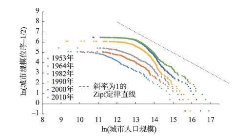
Based on the data of permanent residents from six national population census of China over the period 1953-2010, this study conducted an empirical analysis on the size heterogeneity of city size distribution and the relationship between the evolution of city size distribution and city growth model, to which little attention was paid in previous studies. We selected all cities (including prefecture-level cities and county-level cities) and prefecture-level cities (city propers) alone as samples, and empirically analyzed the morphological characteristics and evolution trends of urban rank-size distribution in China and its relationship with Gibrat's Law. The results show that the main body of city size distribution in China conforms to the linear distribution of Zipf's Law. However, the two ends of the city size distribution spectrum, namely small cities and megacities, deviate from the linear distribution due to insufficient sizes. This phenomenon is not unique to China, but supported by evidence from other countries of the world. From the perspective of evolution, the city size distribution in China gradually dispersed and deviated from Zipf's Law in the early stage. However, from 2000, it began to return to the direction in line with Zipf's Law, with big cities taking the lead in 1990, which shows the coupling with the random growth of urban population in this stage and verifies the logical consistency between Zipf's Law and Gibert's Law. The findings of this study have important implications for promoting the high-quality development of city size distribution in China.
As a window of the Economic Cooperation Belt around the Himalayas, the development of trade and transportation at the Chinese-Nepalese ports is an important support for China's construction of the Grand Opening Channel to South Asia. This study explored the coupling and coordination composite system of ports trade and cross-border transportation of China and Nepal, evaluated the ports trade sustainable development level and the accessibility of cross-border transportation of China and Nepal using an evaluation index and cross-border transportation accessibility model, and analyzed the coupling and coordination relationship between ports trade sustainability and cross-border accessibility from 2010 to 2019 using the coupling and coordination model. The results show that: 1) The composite system of ports trade and cross-border transportation is an organic whole with an interactive coupling relationship. The simultaneous high-level development of ports trade and cross-border transportation is the key to the coupling and coordination of ports trade and cross-border transportation. 2) The overall sustainable development level of China-Nepal ports trade is relatively low, and trade flow is the key for ports trade sustainability. The cross-border transportation accessibility of the Chinese-Nepalese ports has been slowly improved, and the Zhangmu Port has obvious advantages in cross-border transportation. 3) The coupling and coordination of ports trade and cross-border transportation of China and Nepal are moderately out of balance, trade lags behind transportation development, and transportation has a limited role in promoting trade. In order to promote the coupling and coordinated development of ports trade and cross-border transportation, it is necessary to give full play to the cargo transportation function of the Chinese-Nepalese ports, vigorously develop Nepal's re-export trade, and open up the South Asian market. Accelerating the construction of a cross-border economic cooperation zone at Jilong Port, building new channels in the long term to give full play to the cargo transportation function of Zhangmu Port, and using helicopters to develop the "Holy Mountains and Lakes" tourism economy at Pulan (Xie erwa) Port will promote the sustainable development of ports trade.
Urban expansion is mainly reflected in the evolution of urban two-dimensional plane morphology and the expansion of three-dimensional urban space. This study was based on the spatial and temporal data of Zhengzhou urban residential quarters obtained by Internet crawler technology. Ellipse of standard deviation, kernal density analysis, and local indicators of spatial autocorrelation were used to analyze the temporal and spatial characteristics and agglomeration changes of residential districts in Zhengzhou City. The results show that: 1) With the change of dominant factors, the increase of residential area in Zhengzhou City in 1985-2019 was obvious, but it showed a downward trend after 2017; the floor area ratio of residential areas in the city has gradually changed from a slow growth trend to a rapid growth trend. 2) In 1985-2019, the gravity of residential quarter center in the city was mainly distributed at the junction of the five districts, affected by the migration of the total resident population, moving from the southwest to the northeast; affected by the N-shaped moving trend of the gravity of economic center, the east-west migration speed was greater than the north-south migration speed. 3) With the rapid increase of the number of residential quarters, the spatial spillover effect of urban residential quarters was significant, from dispersion to agglomeration, and the high degree of spatial differentiation changed from local to regional balanced. 4) There was an obvious spatial autocorrelation of the floor area ratio of the residential quarters at the residential community scale. The ecological conservation areas and the urban planning restricted development areas are the floor area ratio high-high agglomeration area, and the commercial agglomeration areas are the floor area ratio low-low agglomeration area.
Rural prosperity means national prosperity. Specialized villages (SVs) are the typical model of village economic development and the important starting point to realize rural revitalization. Funded by the Henan Provincial Agricultural Work Office, this study investigated nearly 1200 and 1500 SVs in Henan Province in 2009 and 2018 through questionnaire surveys. Based on the definition of SVs and the evaluation of village economy, 487 and 668 SVs were selected respectively for the two years. Using spatial autocorrelation, nearest neighbor index, and kernel density estimation methods, we explored the spatial changes of SVs in Henan Province. The research found that: 1) In terms of spatial patterns, the SVs in Henan Province had changed from local agglomeration to full-scale diffusion, showing the distribution characteristics of "large-scale dispersion and small-scale aggregation". The number of SVs in southern Henan and southwestern Henan were relatively small. 2) In terms of zoning differences, the core-periphery spatial structure of SVs had gradually faded, and the "V-shaped" partition in the past had gradually changed into a "T-shaped" partition. There were significant differences in the density of SVs in different districts, and there existed the phenomenon of darkness under the lights at the junction of the districts. 3) In terms of the characteristics of change, the spatial distribution of SVs showed an expanding trend, with the center of gravity moved to the southeast. The number of SVs in eastern Henan had increased significantly. 4) In terms of the degree of agglomeration, the agglomeration areas of SVs had changed from a single core to multi-cores. Many secondary agglomeration centers were formed, and the agglomeration extreme value decreased. In some areas, there was a "disappearance under growth".
The expansion of village and town construction land inevitably squeezes the ecosystem space and disrupts the original ecological environment and biogeochemical processes in the system. Under the background of ecological civilization, how to deal with the relationship between village and town construction land expansion and ecological environment protection is a very important question for realizing sustainable development. On the basis of clarifying the coupling and coordination mechanism between village and town construction land expansion and ecological environmental response and taking 2008, 2013 and 2018 as the study years and Rongchang District of Chongqing Municipality as the study area, this study constructed the evaluation indicator systems of village and town construction land expansion and ecological environmental effect. Using the coupling and coordination index calculation model and synchronous development model, this study analyzed the change of temporal and spatial patterns of village and town construction land expansion and ecological environment response in Rongchang District, and divided the types of coupling and coordinated development. The results show that: 1) The expansion of village and town construction land and the response of ecological environment form an interactive coupling relationship with human activities as the link. The analysis of the coupling and coordination state of the two provides a channel for understanding the conflict between development and protection in village and town construction. 2) The coupling and coordination degree of village and town construction land expansion and ecological environmental response in the district showed an upward trend temporally and a low differentiation pattern in space between the north and south. 3) Using the coupling and coordination model and combined with the synchronous development model, the village and town in Rongchang District were divided into three coupling and coordination types: protection and development synchronization type, ecological environment support type, and ecological environment loss type. 4) Differentiated regulatory strategies should be implemented for various types: village and town with protection and development synchronization should give consideration to both economic development and ecological protection; village and town with ecological environment support can develop an appropriate amount of unused land; and village and town with ecological environment depletion should change the current situation of lagging ecological environment protection.
Based on the characteristics of flash floods such as extensiveness, abruptness, and destructiveness, the current focus of disaster prevention and mitigation is to assess the resilience of communities in regions with frequent flash flood disasters, so as to enhance the disaster response level. This study proposed a set of multidisciplinary integrated methods: 1) The quantitative transmission relationship among the indicators of the community resilience evaluation system under the impact of flash floods was clarified by examining the mediating effect. 2) The coupling decision mathematical model of the decision laboratory model and the interpretive structure model was established, the multilevel interpretive structure model of the influencing factors of community resilience was constructed, and then the differential influencing factors of community resilience were analyzed. 3) Information diffusion method was used to quantitatively analyze and rank the community resilience of flash flood disasters. Taking the flood-prone areas in northern Guangdong Province as the research area, this study analyzed three types of communities—that is, towns, villages, and peri-urban areas, and the results show that the community resilience indicator system from the perspective of flash flood impact is a multi-dimensional and multi-layered complex network system, including five aspects: environmental, social, psychological, institutional, and communication. The direct influencing factors of community resilience to different types of disasters are different. The construction of water supply and drainage facilities and flood emergency drills, as the fundamental influencing factors of community resilience, play an essential role in enhancing community resilience to flash floods. Since most of the surveyed villages are located in areas with frequent flash floods, residents have a high awareness of disaster prevention and mitigation and the villages show higher community resilience than the sample towns and peri-urban areas. The study can provide an important reference for improving the resilience of communities in the flood-prone areas in northern Guangdong and their disaster prevention and mitigation capabilities. This comprehensive analysis method can also provide strategic support to the refinement of disaster prevention and mitigation of other types of disasters.
The Lhasa urban circle is a prominent area of ecological environment change and urbanization in the Tibet Autonomous Region. In recent years, there have been ecological and environmental problems such as grassland degradation and soil desertification. The monitoring of the ecological quality of the region is urgent, but currently there is a lack of fine-scale monitoring of ecological quality status in the area. In view of this gap, by taking advantage of the parallel computing capacity of the Google Earth Engine remote sensing big data platform and based on Landsat TM/ETM+ satellite imagery, this study used the remote sensing ecological index method to monitor the temporal and spatial changes of the ecological quality of the Lhasa urban circle from 1994 to 2017, analyzed the climatic and land use transfer factors of ecological quality changes, and explored the temporal and spatial distribution characteristics of comprehensive climate driven ecological quality changes. The results show that: 1) During 1994-2017, the ecological quality of the Lhasa urban circle was good, showing a gradual decrease in space from the southwest to the northeast, and the overall ecological quality showed an improving trend, with an improvement proportion of 45.98%. 2) Heat has been the main internal controlling factor of ecological quality changes, which had a negative impact. 3) Vapor pressure deficit and climate water deficit have been the main climatic driving factors of ecological quality changes, and the transfer of grassland has been the main driving factor of land use. 4) Comprehensive climatic driving force has weakened in the past 20 years, and the impact has gradually increased from the southwest to the northeast. The in-depth analysis of this study may provide a scientific guidance for the protection of the plateau ecological environment and the healthy development of urbanization in Tibet.
Clarifying the climatic factors driving plant phenological changes is vital for assessing the effects of global change on the ecosystem. The previous controlled experiments on European and North American woody plants demonstrated that spring phenological changes were mainly affected by chilling, forcing temperature, and photoperiod. However, it was unclear whether these three climatic factors have similar effects on the spring phenology of East Asian woody plants. In this study, we selected five typical woody plants (Jasminum nudiflorum, Forsythia suspensa, Viburnum dilatatum, Yulania denudata and Cerasus yedoensis) to investigate the leaf-out date of their dormant twigs in growth chambers with controlled environments. We set three forcing temperature treatments (12 ℃, 15 ℃, and 18 ℃), three chilling treatments (3 d, 38 d, and 59 d), and two photoperiod treatments (10 h and 14 h) and monitored the leaf-out date in each treatment. Finally, we established the relationship between the leaf-out dates and the climatic factors using the hierarchical Bayesian model. The results show that 1 ℃ warming in forcing temperature advanced the leaf-out dates by 2.6-9.0 d, but the temperature sensitivity of the leaf-out dates decreased with the increase in forcing temperature and chilling days. Chilling is also an important factor affecting the leaf-out dates of woody plants. Compared with 3 d chilling treatment, 59 chilling days advanced the leaf-out dates by 20.3-66.6 d. However, the sensitivity of leaf-out dates on chilling decreased with the increase in chilling days. Longer photoperiod caused earlier leaf-out dates, but the effect of photoperiod was smaller than that of forcing temperature and chilling. When the photoperiod was extended from 10 h to 14 h, the leaf-out dates were advanced by 0.3-12.9 d, and the effect of photoperiod was more significant in lower chilling treatment. These results provide a scientific basis for understanding spring phenological changes in responses to climate warming over the past decades.
Trade network research originated from complex network science, and its study is related to the globalization research of economic geography. However, relational economic geography, engaging in globalization research and social network and network science, has hardly participated in trade network research. In response to this phenomenon, this article critically reviewed the origin, process, and achievements of the network paradigm of relational economic geography and examined the progress of trade network research, to rethink how relational economic geography should participate in the discussion of trade networks. This article presented the following findings: 1) The network paradigm of relational economic geography only borrows a small part of the concepts of social network analysis, and pays little attention to the overall structure of the network and its influence on collective behaviors. 2) Trade network research mainly discusses the structure and nature of trade networks through building topological network between countries, but relational economic geography based on the actor perspective (for example, enterprises and local agent) is difficult to use social network analysis methods. 3) Relational economic geography should attach importance to global cluster network, and rethink the economic geography foundation of the network concept and the research on the mutual coupling relationship of multi-dimensional networks. This article has implications for expanding the research fields of relational economic geography and for exploring the application of theories and new methods of economic geography.
Venture capital (VC) is conducive to promoting technological progress and the development of high-tech industry. With the development of the VC industry and high requirements for various elements in the process of VC investment such as information, time, and cost, the constraint effect of geographical space has gradually been paid attention to and become an important research perspective. In this context, it is of great significance to examine the research progress of VC investment from the spatial perspective, which can provide some important reference for the related research of geography, finance, economics, and management. 1) This article first clarified the concept of venture capital and summarized the related influencing factors. It then analyzed the framework of VC investment research from the perspective of space. 2) The spatial distribution characteristics of VC institutions, invested enterprises, and investment activities are one of the basic research topics based on the spatial perspective. A large number of studies have been carried out at the global, national, regional, and local levels. Based on these, we summarized the spatial distribution characteristics of VC investment, and revealed the spatial agglomeration characteristics of VC activities from the perspective of supply and demand. 3) From the perspective of VC investment process, the constraint of spatial distance has an important impact in different stages. We summarized the literature on the local bias of VC investment and the impact of distance on investment strategy selection and investment performance. 4) Transport plays an important role in overcoming spatial resistance and expanding human activity space. In recent years, with the construction and development of high-speed transportation, some scholars have paid attention to the impact of transportation operation on VC investment process, especially in terms of local preference and investment performance. Finally, based on the progress and shortcomings of existing literature, this article discussed the future prospects of relevant research. In the future, we can focus on the mechanism of influence and multiscale comparison of the spatial distribution of VC investment, the spatial distribution and regional coordinated development, city network based on VC flows, and the comprehensive impact of transportation development on VC investment.
With the implementation of new technologies such as 5G networks, the Internet of Things, cloud computing, big data analysis, and so on, inclusive and innovative governance and efficient innovation and application of technologies that lead cities towards smartness have become crucial and frontier topics of exploration in current international urban geography. The study of smart cities from the perspective of humanism provides an effective theoretical tool for geographiers in this field. Different from the perspective of technocentrism that regards smart cities as a collection of physical spaces composed of a communication infrastructure network and digital technology, the humanism perspective emphasizes the interaction of technology, humanistic governance (society), and space in a specific (local) context. It calls for a micro-survey of the local cooperation mechanism of information and communication technology (ICT) innovation and smart city construction, as well as governance decision making carried out by multiple actors, with a view to revealing the construction process and localized driving mechanism of smart cities, and with an emphasis on the data analysis of individual actions to find out a development path consistent with local conditions. This study examined the latest developments in humanistic research on smart cities, arguing that current studies still follow the technocentric perspective or adopt the opposite knowledge-centric position, but lack a technology-society synergy perspective. On this basis, this article proposes future research topics that are worthy of in-depth discussion, namely, the symbiosis of technology and society, the complexity of social interactions on technology innovation, and the contextual analysis of technology innovation and interactions. Our discussion may help to understand how smart cities, as a complex human-environment system, undergo transformation in the continuous interaction of people and technology, and provide some theoretical references for the study of smart cities in China.
Along with the development of digital technology, the everyday life practice of local subjectivities are inevitably being interfered by digital technology, and the organization of social space is also being affected by the complex digitization. Despite that the current geographic studies have been increasingly characterized by a trend of "digital turn", the research topic of digital technology impact on rural social and cultural space still needs to be expanded. On this basis, this study first focused on how digital technology shapes and reshapes the spatial spectrum of the rural areas and constructed a theoretical framework of "human society-digital technology interaction". Then, it showed the importance of the social and cultural topics of the geography of digital technology and its value in rural revitalization by focusing on three main research topics: spatial governance, local place making, and temporality. Finally, based on the background of China's rural revitalization strategy, this study used the approach of social and cultural geography to conceptualize the case study of digital technology in rural areas, and explored the potential of digital technology intervention in rural development. The main purpose of this study was to explore the future development direction of the digital technology related to social and cultural geography, so as to appeal to the academic community to further examine the rural social space reconstruction caused by digital technology, and to provide suggestions and a reference for the future development strategy of comprehensive rural revitalization.
In tourism discourses, landscape is the objective manifestation of the interaction between tourism behavior and tourism destination. It links the objective existence and subjective perception, the past and future, and the local and global. It can be a powerful tool to manage the relationship between human and nature in rural tourism. Starting from the interpretation of the concept of landscape and landscape management system, this study systematically examined the essence and context of rural tourism landscape management and the incorporation of landscape management into the human-environment relationship research of rural tourism. The main conclusions include: 1) The ideological logic of rural tourism landscape management includes the balance between anthropocentrism and non-anthropocentrism, the balance between instrumental rationality and value rationality, and the resolution of the paradox between landscape and sustainable development. 2) From the perspective of human geography, rural tourism landscape management is mainly based on the place, space, and landscape theoretical paradigms. The three explain the concept of human-environment relationship from different angles. 3) The technical route of rural tourism landscape management includes two main stages: landscape planning and landscape protection. Landscape ecology methods can be used in quantitative research, and landscape semiotics methods can be used for reference in qualitative research. 4) The research framework of rural tourism landscape management takes ecological issues as the core, and subjectivity, temporal, and spatial issues as the bases.
Tourism flow is an important tourism phenomenon, and it is also one of the core problems in tourism geography research. At present, the overall research situation is characterized by multiple scales, multiple cases and themes, and equal emphasis on big data and refinement. However, most of the existing studies are based on innovations in technical methods or case topics, which mistakenly regard tourism flow as the ultimate scientific problem and research goal. Therefore, the basic theoretical research of tourism flow needs to be re-recognized, strengthened, and enriched. The "Golden Week" holiday tourism flow is a special short-term high-intensity tourism flow restricted by time, space, information, and other conditions. When the concentration of vacation time promotes the tourist flow in some scenic spots to a certain extent, it will inevitably lead to excessive tourism. How to correctly deal with and effectively alleviate the blowout effect caused by the Golden Week and promote the sustained, healthy, and standardized development of holiday tourism still needs further in-depth discussion. Based on the tidal fluctuation, advancing, and retreating phenomenon of holiday tourism flow in attractive scenic spots with well-known brand and resource endowment advantage as core competitiveness, this study deduced the tidal movement theory of tourism flow by comparing with the tidal phenomenon of oceans. A systematic framework of tidal tourism flow research was constructed from the aspects of flow characteristics, spatial process, system dynamics, scale effect, energy characteristics, and digital simulation. The research refined the complicated phenomenon of holiday tourism flow into a simplified theoretical explanation, broke through the bottleneck of traditional tourism seasonality research, and may enrich the basic theory of China's tourism flow research and provide an important practical reference for guiding the practice of Golden Week holiday tourism flow management in scenic spots.
The Earth surface system is a giant system with both complexity and openness formed by the interaction of the atmosphere, biosphere, anthroposphere, hydrosphere, pedosphere and lithosphere, and so on, which has spatial-temporal heterogeneity and hierarchy. Taxonomy is not only the fundamental way to recognize the formation and development of a system, but also an important way to clarify the structure, function, evolution, and spatial differentiation characteristics of a complex system. Classification of the land surface system can provide a scientific basis for multiscale geoscience research and natural resource management. The essence of land surface system classification is the division of the space and relationship between its constituent elements at a specific scale, so land use type, ground substrate, and critical zone type can all be considered as land surface system classification schemes. On this basis, we systematically reviewed the research progress of classification methods of the land surface system in China and internationally, and divided the methods into exploration, development, and mature developmental stages. Then, we compared the connotation of each classification system, and proposed that although each classification system belongs to different schools, they take the land surface system as the research object, and are a methodology to study the structure, function, and spatial differentiation of the land surface system. We compared the similarities and differences in the structure of the classification systems, and summarized the common features of these systems in terms of the level, scale, and elements. Finally, we proposed to build a land surface system classification framework from land parcel to country level, and discussed the prospect of hierarchical structure, classification system, and classification method integration.