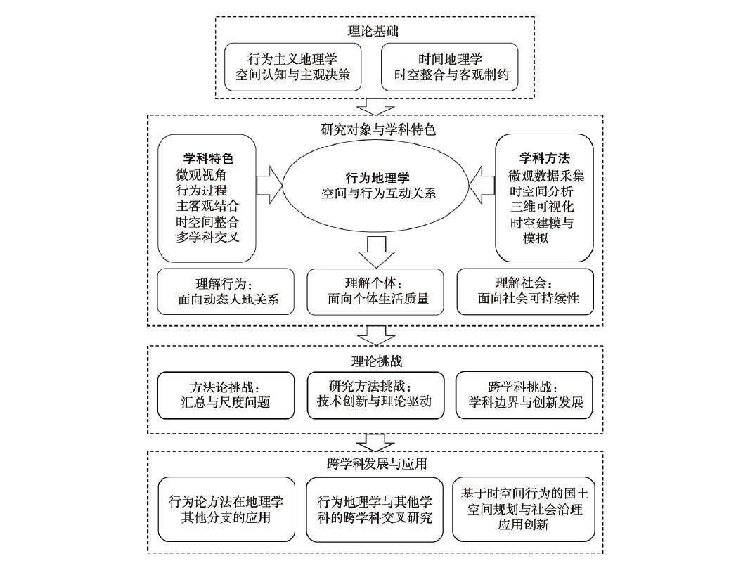
Beginning from the behavioral revolution, behavioral geography has gradually moved towards a diversified development direction, by continuously expanding its theoretical framework and practical extension, as well as reflecting on its own meaning. It is an important part of human geography. In the 21st century, geographic mobility has increasingly become a core factor in shaping human-environment relationships. Mobility not only constitutes a new mode of operation of the world through flows and networks, but also fundamentally reshapes the relationship between geographic space and social space. As an important part of geographic mobility, space-time behavior demonstrates the diversity and dailyness of mobility, which is key to understanding urban and rural space and social development. This brings new opportunities for the development of behavioral geography, which promotes related research to micro-interpretation, simulation, and evaluation, and puts the actual problems of people and society at the core of the research. To understand the recent development and future direction of behavioral geography, this article examined the disciplinary position of behavioral geography, reviewed the latest research results of behavioral geography in the past 10 years, discussed the challenges faced by the development of behavioral geography, and explored its future development trends. Behavioral Geography is a branch of human geography describing and explaining the interactions between the geographical environment and human behavior. The core is to explore how people's spatial behaviors are generated in the geographical environment and how people's behaviors react to space. Behavioral geography has five characteristics, including microscopic perspective, behavioral process, subjective and objective combination, integration of time and space, and interdisciplinary. The development of behavioral geography has experienced rise, integration, and expansion, and has gradually developed from the initial narrow positivist framework to more diversified directions. In the recent years, behavioral geography has presented three frontier development directions, including understanding dynamic human-environment relationship, individual quality of life, and sustainable social development. First, behavioral geography provides a new perspective to understand the interaction between geographic space and individual behavior from the perspective of micro-processes. It includes three new directions including analyzing dynamic geographic backgrounds, emphasizing the combination of subjective and objective, and deepening the understanding of cognitive space. Second, behavioral geography focuses on the quality of life at the individual level, and understands the quality of life and its changes from the perspective of temporal and spatial behavior. The main topics include lifestyle, social relations, subjective well-being, and physical and mental health. Third, behavioral geography understands urban issues and improves urban governance from the perspective of micro-processes, and bridges the gap between individual research at the micro-scale and urban spatial research at the macro-scale. It brings a behavioral perspective on social equity, smart cities, low-carbon cities, and planning applications. Behavioral geography faces challenges in methodology, research methods, and interdisciplinary aspects. It needs to think about aggregation and scale issues, develop theory- and problem-oriented research, find new interdisciplinary development points, consolidate the core of geography, expand its boundary, and optimize its theoretical system.
Behavioral geography is an important subdiscipline of human geography. It provides innovative approach and special angles for interpreting human-environment relationship. Behavioral geography had experienced rapid development in the 1970s, which was considered an era of "behavioral movement". However, the development of behavioral geography slowed down in Western geography since the 1990s and few theoretical and methodological progresses had been made until recently. Moreover, there are some confusions about the unique features and theoretical contributions of behavioral geography within both the subdisciplines of human geography and the general "behavioral science". This situation is detrimental for researchers in other subdisciplines of geography to realize the values of behavioral geography and for the communication and consensus building among behavioral geographers. Recently, the professional committee on behavioral geography was founded in the Geographical Society of China. This provides new opportunities for the development of behavioral geography in China on the one hand, yet makes more pressing requirements for discussing the disciplinary and theoretical issues in behavioral geography on the other hand. Therefore, this article summarized four related unique features of behavioral geography and provided some referential directions for future studies. Specifically, this article argued that behavioral geography is both a subject of specific objects (environment-behavior relations) and a methodological science (behaviorism), and provides individual, subjective, and process-centered perspectives to interpret the relationship between human behaviors and geographical environment. Behavioral geographers should pay more attention to the questions related to spatial behavior and behavior-environment interaction instead of behaviorism. The models and explanations at the individual level should be extended to the group level in behavioral geography. Continuous efforts should be made to explore the mediating mechanisms of psychological processes when explaining the relationship between human behaviors and geographical environment, yet more attention should be paid to models based on subjective well-being and more robust tests of causal relation. Chinese behavioral geographers should enhance their own specialty and knowledge contribution by probing into group behaviors within collective culture and exploring more applications in behavioral geography. This article may clarify the values of behavioral geographical studies, further the theoretical debates in Chinese behavioral geography, and draw more scholarly attention to some promising directions in behavioral geography.
Since the behaviorist revolution in the 1960s, human geography has started to explore the micro geography research from an individual perspective, and gradually formed the behavioral geography research with a typical microscale human-environment relationship research paradigm. However, the current research is still insufficient in exploring the microscale human-environment relationship. This has led to the slow development of the microscale human-environment relationship theory and limited guidance in practice because the macro and micro research scales are separated. Therefore, this article summarized the behavioral geography methodologies, and research paradigms of human-environment relationship including regionalism, positivism, behaviorism, humanism, and structuralism from the perspectives of ontology and epistemology. By comparing the differences between the macro and microscale human-environment relationship research paradigms, we found that the behavioral geography research paradigm has formed a theoretical and methodological basis for exploring the microscale human-environment relationship. By establishing the connection with other research paradigms and based on the basic connotation and objectives of the microscale human-environment relationship research, we can reconstruct the basic viewpoints and methodology of microscale human-environment relationship research and build a cross-scale research paradigm from the micro level to the macro level, to inspire the development of behavioral geography and the microscale human-environment relationship research.
Behavioral geography focuses on the relationships between space and behavior. After decades of development, as well as the constant improvement of theoretical basis, the deepening of research methods, and the extension of research topics, behavioral geography has gradually moved towards diversification and socialization, and consequently become an important subdiscipline of human geography. Its theories, methods, and empirical research results have also been widely used in research and practice in many disciplines. This research expounds the interdisciplinary basis of behavioral geography in terms of theory, method, and application. With respect to theoretical basis, behavioral geography originated from the disciplines of geography and psychology, and then absorbed the closely related theories and methodologies, especially time geography and activity-based approach, which constitute the core theoretical basis of behavioral geography. The research methods of behavioral geography have become diversified in the process of interdisciplinary integration. Methods from disciplines such as computer science, geographic information science, sociology, statistics, and biology have been draw into behavioral geography in terms of collection of behavioral data, mining and visualization of behavioral pattern, as well as analysis and simulation of mechanism of behaviors. In regard of application research, behavioral geography has been deepening the integration with different disciplines, and our study elaborated the application research combined with behavioral geography from three aspects: urban planning and design, mobility planning and management, and sustainable social development and governance. This research aimed to explore the influence of behaviorism on geography and adjacent disciplines, clarify the interdisciplinary context of applied research around behavioral geography, further promote the interdisciplinary development of behavioral geography, and explore future research and application directions. Looking forward to the future, there is still much room for the interdisciplinary integration and application of behavioral geography. In terms of theoretical construction, further research and discussion on the space-behavior interaction theory by different disciplines are needed. For practical application, behavioral geography guided by the improvement of quality of life and sustainable social development has good interdisciplinary application prospects, and is expected to play a greater role in smart city planning and management, living space planning, living time planning, as well as residents' behavior guidance and service. In particular, how to arrange the dynamic spatial allocation of cities from the three dimensions of space, time, and individual behavior is the key direction of exploration of combined behavioral geography and planning practice.
All-ecological worldveiw as well as the focus on the process and the complexity of human-environment interaction are the theoretical core of time geography, which are also the key questions of the theoretical construction of space-behavioral interactions within behavioral geography, while the concepts of project and pockets of local orders are the latest development in new time geography. This article reviewed the theoretical development and the frontier of time geography in recent years from three aspects, including the project-activity system and its changes, social interaction under the interwoven organizational project and individual project, and the process of project realization by the construction of pockets of local orders. The development of new time geography further improves the interpretation of the human activity system and deepens the understanding of the complex mechanism of human and environmental interactions. This article systematically examined the interdisciplinary and innovative application of time geography in transportation, urban and regional planning, geography, occupational therapy and health, and resources and energy use. It calls for more attention from researchers to time geography in future research by using it and carrying out interdisciplinary application, carrying out international comparative study on time geography, further developing the behavior paradigm of Chinese urban research, enriching Chinese urban space-behavior interaction theory, and contributing to the high-quality social and economic development of Chinese cities.
Time geographic kernel density estimation is an extension of classical kernel density estimation (KDE) based on time geography. It mainly extends the definition domain of the standard kernel function to the space-time reachable domain of time geography, so as to avoid the problem of non-zero density being assigned outside the reachable domain by enhancing the physical meaning of the definition domain in space-time. The space-time reachable area includes the space-time disc and the potential path area (PPA) compounded by the space-time disc. These two types of reachable domains can be used as the domain of the kernel function to solve the above problems, but they also bring new problems. The kernel function constructed based on the space-time disc can be superimposed into the probability density on the PPA, but it is sensitive to the time point of the disc. Compared with the ideal Brown Bridge model, the kernel function constructed based on PPA lacks bimodal characteristics, and cannot generate the probability density function on the space-time disc. Therefore, the research on the combination of time geography and KDE is still in the stage of theoretical exploration before application. The goal of this article is to sort out this process and elicit future development trends. Focusing on the goal of quantifying the uncertainty of space-time trajectory, this article first reviews the different functions of time geography and KDE, and then elaborates the meaning, framework and mode of the integration of the two. Finally, this article believes that the time-geographic reachable domain instead of the domain of KDE is an important means to improve the uncertainty measurement of space-time trajectory, but there is still a certain distance from the landing of the target.
Cognitive map, as the internal representation of abstracting and ordering the complex system of human-environment relationship, is the theoretical basis of individual spatial behavior decision making, spatial cognition, and spatial planning. It is also one of the important research fields of behavioral geography. This article systematically reviewed the research progress of cognitive map in geography and urban planning, psychology and neuroscience, computer science and engineering, and business economics and management science. It also summarized the definition, research hotspots, and historical development of the cognitive map. Through CiteSpace clustering analysis and reviewing classical literature, it is found that cognitive map research plays an important role in the disciplinary development of behavioral geography, especially in cognitive space and city image, spatial distortion and preference, spatial knowledge, and decision-making behavior. Recently, the interdisciplinary research of cognitive maps related to behavioral geography has three turns: digital turn, emotional turn, and neural turn. Finally, this article identified the role and application prospect of the geography of cognitive map spatial analysis in the development of interdisciplinary integration.
The digital revolution produced by digital technology progression has been significantly changing the urban economy, society, and spatial systems. A number of new digital behaviors, including e-shopping, riding-hailing, and instant delivery, have increasingly emerged in urban everyday life. Spatiotemporal behavior studies, in particular behavior geography and time geography, have intensively investigated these new behavior phenomena. However, there is still great potential to develop new frameworks for understanding the behavioral changes in a digital society. This framework should go beyond the current dichotomy of frameworks that divides all behaviors into those with or without the engagement of modern information and communication technologies (ICTs) and further study how these ICT-enabled activities combine with physical activities. With insights on the whole course of digital behaviors and their outcomes, this study aimed to incorporate the theory of environmental affordance and dynamic interaction to look at how the digital society changes the traditional constraint-centered paradigm. This article summarized these changes in three aspects and categorized them into three kinds of "augment effects". First, the information provision for decision making evolves from static to dynamic and real-time. It changes the Information asymmetry between human and the environment reality, and creates flexibilities for adjusting behaviors at any time and in any locations. Second, the digial society has facilitated a number of the behaviors fulfilled by multiple agents rather than solely replying on the actor him- or herself. It creates a mechanism by which a number of behaviors could be outsourced and entrusted to others. It also creates huge abilities for individuals to make daily activitiy arrangements. Third, the space and time where the behaviors could happen have been enlarged. It suggests that the place where activities rarely happened without Internet enagement would be a site that digital behaviors could access. It creates the diversity of activities through time. These three augment effects could be attributed to the engagement of digital platforms. The digital platform is increasingly attracting the facilities and services to be presented online. The agglomeration benefits created by one-stop effects further attract the infux of end users. The two-side network effects render the platform the role of intermediator and infracture in the interaction between human behavior and the environment. It empowers the users to access, acquire, and use the resources and opportunities affiliated with any platform. Responding to these changes, this article suggests that temporal and spatial behavior research needs to increase the spatial resolution of behavior research and analyze the dynamics of the situation. It is essential to explore the scene design that supports the realization of behaviors. One argument of this research is to transform accessibility planning to availability planning and improve the spatial-temporal availability of social resources and opportunies. To achieve this transformation, it is necessary to study how to organize spatial planning by time, and improve the responsiveness to temporal and spatial behaviors in the digital society.
The information and communication technologies (ICTs) have made great impact on everyday life. However, there are few publications reviewing the relationship between ICTs and the digital transition of everyday life. In addition, little attention has been paid to the analysis of the theoretical progress and mechanism. Time geography timely responds to the digital transition of everyday life. This article reviewed the basic characteristics of digital transition of everyday life, including fragmentation, multitasking, and space-time displacement. Such empirical studies are usually inconclusive–one of the reasons is that they try to answer whether and how ICTs have changed everyday life while neglecting the underlying mechanism. The recent progress of time geography has provided a great theoretical base and analytical and descriptive tool to the digital transition of everyday life. First, the theories and concepts of the classical time geography have been extended to applied to the behavior in virtual space. It is found that space-time decoupling and the relaxation of space-time constraints are the underlying mechanism of the digital transition of everyday life. Second, visualization and analysis tools based on GIS have also been developed to visualize and analyze the hybrid physical-virtual space behavior. However, the intrinsic absolute space and time of GIS is inadaptive to the basic characteristics of the digital transition of everyday life. The decoupling has dissolved the one-by-one relationships between space-time position and activity, and fragmentation and multitasking have made the before-and-afterness as well as the side-by-sidedness more important than the absolute position in space and time. Therefore, third, the visualization of the complex activity contexts of new time geography can jump out of the three-dimensional visualization framework based on GIS, and demonstrate the fragmentation, multitasking, space-time displacement, and the complex relationships between online and offline activities of the daily activities in the hybrid physical-virtual space. Besides, the concepts of foreground and background activity, mediated bundle, and pockets of mediated order have been proposed, which are powerful in understanding the transition of everyday life under the impact of mobile ICTs. We finally proposed a time geography analytical framework of the digital transition of everyday life with the core of physical-virtual hybrid activity system. The digital transition of everyday life will be the important direction of space-time behavior in the future information society. We also discussed future research topics including digital life, smart society, and safe city.
In the context of China's new-type urbanization, how to build more inclusive and equitable cities has become an important question for sustainable social development. Research on transportation-related social exclusion mainly includes theoretical research, socio-spatial analysis, and comparative research on transportation and social exclusion. Supported by a large number of theoretical and empirical studies, two paradigms have been formed: the research based on "space" and the research based on "classification" of specific social groups. However, there is still a lack of effective demonstration of the internal causal relationships between space and behavior. Therefore, it is urgent to clarify the concept and mechanism of transportation and social exclusion from the perspective of geographic space and spatiotemporal behavior of different social groups. This article reviewed the concepts, research paradigms, and measurement methods of transportation and social exclusion, and elaborated on the internal logic and empirical results of social exclusion research in transportation from the perspective of spatiotemporal behavior and activities. Then, a research framework of transportation and social exclusion based on space-time-behavior interaction was constructed based on China's reality. The article attempted to provide a practical and theoretical support for the elimination of social exclusion in transportation, the construction of multi-scale social integration, and the development of more inclusive, equitable, and just cities.
Consumption upgrading breeds new business forms of consumer services, which changes the urban spatial pattern of consumer service industry. This study took the food markets as a representative of consumer service space, selected Wuhan City that experiences urban consumption upgrading and post-epidemic recovery as a case area, and integrated GIS spatial analysis and STATA statistical analysis techniques to analyze the formation process, types of markets, and influencing factors of the food market system. The results show that: 1) The food markets in Wuhan City had experienced a development process from the traditional farmers' market to the expansion of new retail formats and then down to the community scale. They had formed a new compound consumer service space with the fresh food products department of hypermarket, farmers' market, fresh food products supermarket, and community vegetable shop, and this system showed a certain resilience after the epidemic. 2) The spatial structure of the food markets changed from dual-cores to multi-cores, and the spatial distribution extended from the city center to the periphery. The spatial layout of different types of food markets presented the differentiated distribution pattern of cluster-shaped (farmers' market), strip-shaped (fresh food products supermarket), punctiform-shaped (hypermarket), and butterfly-shaped (community vegetable shop). 3) The spatial configuration of all forms of food markets was significantly influenced by social, economic, and locational factors and development foundation, traditional food market layout was significantly affected by market and locational factors, and new retail format food market layout was significantly affected by economic factors and early food market agglomeration basis. Under the situation of consumption upgrading, the site selection of new food markets prefers experiential consumption places represented by shopping malls. This study has a certain theoretical significance for enriching the research of modern food market system, expanding the disciplinary perspectives of urban consumer service space research, and has a certain practical value for optimizing the spatial structure of urban consumer service to meet residents' increasing needs for a better life and the pursuit of service quality.
With the rapid development of China's high-speed railways (HSR), the impact of high-speed rail construction on urban and rural residents' income gaps has gradually become an academic topic. By constructing an HSR station accessibility indicator, this research illustrated the impact of HSR stations on urban and rural residents. Based on the literature review, it revealed the spatial spillover effect of transportation infrastructure on urban and rural residents' income gaps. Using the prefecture-level city data of China from 2010 to 2017, this research adopted the proximity matrix in the spatial Dubin model to analyze the spatial spillover effect of high-speed rail construction on urban and rural residents' income. The empirical results show that: 1) At the national level, the increase of high-speed rail stations is positively related to urban and rural residents' income gap change, and the spillover effect is also significant. 2) At the regional level, the positive relationship between the increase in the number of high-speed rail stations and urban and rural residents' income gap change mainly exists in the central and western regions of China, while this relationship is not apparent in the eastern region. 3) The trend of the spillover effect of high-speed rail stations on urban-rural income disparity increased across the periods 2010-2014, 2010-2015, 2010-2016, 2010-2017, but the increase of spillover effect in 2010-2017 weakened. Since 2016, the number of new high-speed rail stations has decreased compared with previous years. The spillover effect of high-speed rail station accessibility on the income disparity of urban residents has gradually reduced. Therefore, policymakers need to pay more attention to the impact of high-speed rail stations on urban and rural residents' income gaps, especially in prefecture-level cities with a low proportion of the primary industry. Optimizing the layout of new high-speed rail stations and coordinating the distribution of transportation infrastructure between urban and rural areas are important ways to narrow the income gaps between urban and rural residents.
Taking the central urban area of Shanghai Municipality as the study area and using the enhanced two-step floating catchment area method (E2SFCA), this study evaluated the accessibility of urban fire service (UFS) under the impact of a 100-year pluvial flood, which can cause extensive road closures. A high-resolution hydrodynamic model (FloodMap-HydroInundation2D) was used to produce flood scenarios at very fine spatiotemporal scales. The results show that: 1) Under the flood scenario, the most serious flood extent (water depth > 50 cm) totals about 1.5 km2 and may cause 471 road closures (accounting for 5.11% of the entire road length). Flooding on the west side of the Huangpu River is slightly more severe than the east. 2) The spatial distributions of UFS accessibility are not the same at different time periods of the day, but they show a very similar pattern that the accessibility decreases from both sides of the Huangpu River to the northwest and the southeast peripheral areas. 3) Compared with normal weather situation, the number of inaccessible spatial units (250 m × 250 m) at the night, morning peak, nonpeak daytime, and evening peak hours increases by 36.32%, 35.89%, 39.07% and 32.01% respectively under the flooding scenario. During the entire process of the pluvial flood event (120 min), both the maximum number of inaccessible units and the most significant spatial variance emerge at the second phase of the rain peak (30-45 min). 4) Urban fire service accessibility displays significant spatial agglomeration characteristics under both the normal and the flooding scenarios. The High-High clusters are mainly located along the two sides of the Huangpu River and the western peripheral areas, while the Low-Low clusters are primarily distributed in the northwest and southwest. Neither the High-Low clusters nor the Low-High clusters are significant. 5) The spatial mismatch of UFS demand and accessibility (low demand-high accessibility or high demand-low accessibility) is evident even under the normal weather situation, and can be further aggravated if a 100-year pluvial flood occurs. These results can provide a scientific support for improving the smart management of pluvial flood disaster and emergency response service in urban areas.
As an open human-natural system with a complex organizational structure, the urban system has always been the core object of geographic research. Using the published literature from 2000 to 2020 as the data, we developed a new approach by combing quantitative and qualitative analyses to investigate related research results from the perspective of geography in terms of conceptual connotations, research themes, and technical methods, and put forward the future research needs. Over the past 20 years, urban complexity research in China has gradually shifted from single-scale pattern, process, and mechanism research to integrated and comprehensive research on complex interaction processes at multiple scales, and has gradually formed four major themes, including urban facility networks, urban habitat, urban economic activities, and urban spatial governance. In terms of data analysis methodology, the research has gradually shifted to multi-dimensional scenario analysis supported by spatial technology and social computing with panoramic whole-life cycle data. In the future, urban complexity research from the perspective of geography needs to further strengthen the construction of urban digital infrastructure and life cycle information collection capability, deepen the comprehensive measurement and monitoring of urban ecological-economic systems from the perspective of geospatial pattern, and study the urban flow space under the influence of cross-regional development mechanism.
Drought propagation is an important topic in the drought research field, and its theory and research framework are not yet complete. This article elucidated the spatiotemporal conception of drought propagation from the perspective of geographic sciences, and comprehensively revealed the characteristics and patterns and summarized the research status of drought propagation following the steps of defining the concept, quantifying the characteristics, and describing the processes, which has an important theoretical significance for a deep understanding of the evolution process and driving mechanism of drought propagation throughout a drought. First, the article defined the conception of drought propagation from the spatiotemporal dimensions in a comprehensive manner based on the principles of geographic sciences. Then we analyzed the spatiotemporal characteristics of drought propagation and examined the research approaches and methods, and subsequently explored the main influencing factors of drought propagation. Finally, this article summarized the research framework and provisions based on the characteristics, processes, and mechanisms of drought propagation. A review of Chinese and international literature showed that drought propagation is characterized by the two-dimensional attributes of space and time, which was mainly controlled by the catchment characteristics, climate change, and anthropogenic activities. However, the previous studies have focused mainly on the lag time and probability of drought propagation, and are inadequate in exploring the spatial dimension, describing the evolution process, and identifying the driving mechanism of drought propagation. Revealing the process and mechanism and the formation and transition of meteorological drought, hydrological drought, agricultural drought to socioeconomic drought is the essence of drought research and the primary prerequisite for formulating effective drought control measures. Understanding the characteristics and process and mechanism of drought propagation is a key component of drought research.