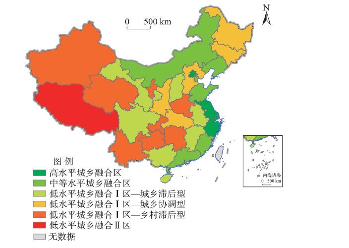
Urban-rural transformation (URT) is a comprehensive process with the characteristics of multi-domains and multi-levels. A scientific understanding of the concept and connotation of URT and a systematic discussion of the patterns and mechanism of URT are of great significance to solving the problems of unbalanced urban-rural development and insufficient rural development. Based on the theoretical cognition of URT, this study comprehensively analyzed the urban-rural development level and its spatial-temporal patterns in China, revealed the patterns of URT according to the coupling coordination degree of urban-rural development level, and discussed the key of urban-rural integrated development in different types of URT areas. The results show that URT is the result of the interaction between the change of urban regional system and the change of rural regional system, and its external representation is the coupling coordination state of the two different but closely related processes. From 2000 to 2018, the level of urban and rural development in all provinces of China's mainland has risen rapidly, and the coupling coordination degree of urban and rural development level has changed from being on the verge of imbalance to intermediate coordination. Spatially, the provincial coupling coordination degree of the central and western regions is significantly lower than that of the northeast and eastern regions. Accordingly, URT in China has realized the transformation from low-level urban-rural coordination to medium-level urban-rural integration, showing a spatial characteristic that provincial URT in the central and western regions lags behind the eastern areas, especially Beijing and the provinces in the Yangtze River Delta, where urban-rural development has entered or will soon enter the stage of high-level urban-rural integration. According to the features of URT in each province, URT in China can be divided into four types, that is, high-level urban-rural integrated area, medium-level urban-rural integrated area, low-level urban-rural integrated area Ⅰ, and low-level urban-rural integrated area Ⅱ. To continuously promote the development of new-type urbanization and the implementation of rural revitalization strategy, it is urgent to establish and improve the system and mechanism of urban-rural integrated development through measures such as deepening the reform, innovating the mechanism, and making up for the shortcomings.
Understanding the patterns of city size distribution around the world is important for the formation of reasonable city size distribution and high-quality national economic development. Based on a panel two-way fixed effects model and multiple databases such as LandScan from 2000 to 2018, this study identified the spatial and temporal change characteristics of city size distribution at the national level and analyzed its influencing factors as well as their heterogeneity based on global cities with a uniform definition. It was found that city size distribution across countries showed a fluctuating equalizing trend. In terms of spatial change, African and South American countries showed gradually equalized city size distribution, while Asian and European countries showed a trend of polarization. In a comparison of the present situation, African countries lead in the polarization of city size distribution, while European countries are the most equalized. Higher river densities, city population densities, and industrialization levels promote a equalized city size distribution, while larger topographic relief and national unrest reinforce their polarization. Compared to other factors, the socioeconomic factors (especially urban population density) have the most significant impact on the heterogeneity of city size distribution across countries with different income levels, industrial structures, and levels of government intervention. Although increased city population density contributes to a more equalized city size distribution overall, it has a significant polarizing effect in service-dominated and weak government intervention countries and a less pronounced effect in high-income countries. The balancing effect of industrial development on city size distribution and the polarizing effect of increased railway density are more significant in low-income countries, manufacturing-dominated countries, and countries with weak government intervention. Increased economic development significantly contributes to the polarization of city size distribution in service-dominated and weak government intervention countries and the expansion of openness contributes to the equalization of city size distribution in high-income countries. The increase in city population and internet penetration contributes to polarization and equalization of the city size distribution in countries with strong government intervention, and the increase in government spending only has a balancing effect on the city size distribution in countries with strong government intervention. This study deepens the knowledge of the patterns of city size distribution and its formation mechanism, and provides strong empirical support for the formation of a reasonable city size distribution. In the future, China should reshape the national economic geography by constructing an appropriately equalized city size distribution, expanding the two-way internal and external openness, and applying new generation information technologies.
Multilevel spatial models of innovation activities and innovation networks have been the focus of researchers. To provide more direct evidence for multilevel spatial model of innovation, we chose the new energy vehicle industry (NEV industry) as an example, because the knowledge in NEV industry is tacit and codified, which means it would be with a significant multilevel feature. This study used the patent data of 2004 to 2018 from the State Intellectual Property Office (SIPO) to analyze the multilevel spatial characteristics of China's NEV industry innovation from 2001 to 2015 because the patents in China would be published 18 to 24 months after the application and there is a time lag of almost 3 years between innovation input and output. We used the Theil coefficient to understand the multilevel structure, the coefficient of variation (CV) and Gini coefficient to clear the variation and difference of innovation at multiple levels, and the local Moran's I, Getis-Ord $G_{i}^{*}$, and natural breaks (Jenks) to map the spatial agglomerations and clustering. The results show that: 1) At the municipal level resides the strongest explanation of innovation activities and they are mainly agglomerated in the eastern coastal region (ECR) and northern coastal region (NCR), and the distribution of innovation activities are greatly different at the municipal level. 2) The regional level has the strongest explanatory power of internal and external innovation networks and they are mainly clustered in the ECR and NCR, and the distribution of innovation networks are quite different at the municipal level. 3) The distributions of innovation networks and innovation activities are significantly different at different spatial levels. Based on this reality, we point out that the formation mechanism of innovation activities and innovation networks are different. The spatial pattern of innovation activities is affected by regional innovation system, and the innovation networks are the result of actors' choices. We argue that it is difficult to explain the spatial characteristics of innovation networks only from the spatial perspective. Therefore, it is necessary to examine the formation process of innovation networks from a more micro level. Because the municipal level is the most important place for innovation activities and the regional level is the key area for innovation networks, as the Theil coefficient shows, we actually provide direct evidence for the multilevel structural nesting feature of innovation activities and the multilevel initiative interaction feature of innovation networks. It would be necessary for researchers to discuss the differences between them in the future.
Resilience is a basic characteristic of the rural system, which plays a crucial role in rural revitalization. By the end of 2020, China had completed the mission of poverty alleviation in the new era. However, rural development in some areas is of low quality and when facing external risks and challenges, these areas have the risk of returning to poverty. Therefore it is urgent to improve rural resilience. This study selected Yangyuan County of Hebei Province in the contiguous poverty-stricken area of Yanshan-Taihang Mountains as the research object. The "Pressure-State-Response" (PSR) model was constructed to comprehensively evaluate the rural economic resilience. The study found that: 1) The average value of rural economic resilience in Yangyuan County is 0.13 (total score is 1), which indicates that the quality of rural economic development is not high. 2) The areas located near the town and township seats and close to the main traffic lines display high economic resilience. In contrast, mountainous areas and areas far from the main traffic lines display low economic resilience. 3) Low per capita income of rural households, low per capita arable land, and insufficient investment in rural fixed assets are the main constraints to economic resilience. The article proposed four aspects to improve rural resilience: establishing multi-level development system of "individual farmers-rural collectives-urban centers", strengthening the development of infrastructure such as rural transportation and communication systems, promoting farmers' skill training, and strengthening the collective economy of the villages. Developing key towns-central villages-new rural communities effectively accelerates the development of ruralization, which drives rural development together with urbanization.
:Peri-urban areas are transitional urban areas with urban-rural mixed landscape and functions, and the positive change of peri-urban areas is essential to achieve the mission of urban-rural integrated development. The accurate identification of the spatial scope of peri-urban areas is a prerequisite for managing such areas, and a scientific understanding of the change of peri-urban areas can provide important references for its future development. However, due to the high complexity, dynamics, and fuzzy boundary of peri-urban areas, there is still little progress in fine-scale and quantitative identification of such areas. Under such backgroud, this study established a methodology for identifying peri-urban areas supported by remote sensing data, comprehensively considering the complexity and multi-dimensional characteristics of peri-urban areas. First, a comprehensive indicator system across socioeconomic and spatial pattern dimensions was established. Second, a measurement for peri-urban index was developed by using spatial gridding and linear weighting methods. Third, combined with the moving t-test and probability density analysis, the threshold for distinguishing peri-urban areas and non-peri-urban areas was determined. Finally, taking Suzhou City as a case, the peri-urban areas of the city in 2010, 2015, and 2018 were identified at the 1 km × 1 km scale. On this basis, the pattern of change of Suzhou's peri-urban areas was further discussed. It is expected that the research results can provide some references for future urbanization process of Suzhou City and other regions. The case results show that the peri-urban areas of Suzhou are spatially discontinuously distributed around the central urban district, and temporally experience a decreasing trend, especially during the period of 2015 to 2018, which indicates that the urbanization process of Suzhou City tends to be under control, and the city's rural industrialization and urban sprawl have slowed down.
Characteristic Protection Villages (CPVs) are one of the four basic types of villages identified in the national strategic plan for rural revitalization. However, further subdivision is also needed for targeted measures due to the clear differentiation of these villages. Following the problem-oriented and theory-guided classification principle and aiming at addressing the balance of protection and development in CPVs, this study drew on the symbiosis theory to build a conceptual model of symbiosis system, and subdivided the types of revitalization according to the differences in symbiosis system types and compositions. It selected 8173 national CPVs as empirical study samples to identify the sample types and clarify the revitalization models. The results show that: 1) The symbiosis system of CPVs can be divided into three types: ectosymbiosis, endosymbiosis, and both endosymbiosis and ectosymbiosis. There are four symbiotic relationships: symbiosis between a village and external entities, symbiosis between village characteristic resources and industry, symbiosis between village characteristic cultural resource and living environment, and symbiosis between village characteristic resources, industry, and external entities. 2) Based on the similarities and differences in symbiotic relationships, the CPVs were divided into 10 revitalization types with 47 tourist destinations, 75 cultural and tourism integration sites, 251 agricultural and tourism integration sites, 47 characteristic agriculture sites, 442 scenic-reliant sites, 1463 market-driven sites, 2159 transportation-driven sites, 160 historical memory protection sites, 1543 ethnic characteristic protection sites, and 1986 regional culture protection villages. 3) The revitalization model of CPVs varies and includes seven types: "optimizing and upgrading, and demonstrating and leading", "deep integration and value-added empowerment", "brand-strengthening agriculture and characteristic clustering", "leveraging scenic spots and complementing villages and scenic spots", "targeting the market and connecting villages and cities", "linking transportation and integrating symbiosis", and "village living protection and nostalgia retention".
Rural human settlements are the facilities and conditions for farmers to carry out their daily production activities and living. The adaptability evaluation of rural human settlements based on subjective and objective comparison is a requirement to practice the "people-centered" development concept and promote the implementation of the strategy of rural revitalization in China. On the basis of evaluating the comprehensive development levels of villages and towns/townships of Gong'an County on the Jianghan Plain, this study selected 50 villages in 5 towns as samplings, and conducted a household survey to obtain data by using the methods of semistructured interview, stratified sampling, and random sampling in September 2017. This study analyzed the rural human settlement environmental supply with the accessibility of rural living space, interpreted the farming households' demand with the residents' satisfaction of living conditions, and deconstructed the difference between supply and demand with the adaptability of rural human environment. Two adaptability modes and nine adaptability types of rural human settlements supply and demand were proposed. Adaptability was evaluated by using entropy method, fuzzy comprehensive evaluation, natural break and maximum membership principle, and then, the direction and path for the optimization of rural human settlements were put forward. The results show that during the study period, the maximum distribution of rural living space accessibility was 44.75%, which belongs to the medium level category, and the accessibility of employment space and leisure space was the weakest; the maximum distribution of satisfaction of rural human settlements in the case area was 0.467, belonging to the medium level category, and the satisfaction of the rural natural environment and economic operation environment was the lowest. Although the adaptability between subjective demand and objective supply are all of "medium-medium" pattern at the county and the individual farming household scales, there are differences in different dimensions and at different scales. The research results can provide a scientific basis for the construction of rural human settlements and rural revitalization in the case area and similar regions.
Along with the development of "people-centered urbanization" and a series of household registration (hukou) reforms, promoting the conversion of floating population into urban residents (shiminhua) has become a priority task of China's urbanization. The permanent settlement intention of floating population is one of the driving forces to promote the urbanization of floating population. Based on the 2017 China Migrants Dynamic Survey conducted by the National Health and Family Planning Commission and China's city statistical yearbook 2017, and using the spatial visualization function of ArcGIS and multiple linear regression model, this study analyzed the spatial pattern and determinants of floating population's permanent settlement intention between prefecture-level cities in China. The results show that the overall level of the floating population's permanent settlement intention is only 27.2%, and there is a significant variation of floating population's permanent settlement intention between prefecture-level cities among cities of different sizes and geographical regions. The flow of permanent settlement intention forms a multipolar pattern with Shanghai, Shenzhen, and Beijing as the main cities, and the core cities of some inland urban agglomerations as supplement. Meanwhile, the floating population prefers the three major coastal urban agglomerations of the Yangtze River Delta, the Pearl River Delta, and the Beijing-Tianjin-Hebei region, and with the increasing intention of permanent settlement, the choice of cities is increasingly focused on a few big cities. The modeling results reveal that the more stable of employment environment and higher wages of the destination cities than the cities of origin, the stronger intention of floating population to settle permanently. The gap of the wage and unemployment rate between the destination cities and cities of origin significantly affects the floating population's permanent settlement intention. Female, older people, and people with higher levels of educational attainment, short distance of migration, longer duration of residence in the host city, and family migration, have significantly higher permanent settlement intention. Moreover, owning houses in the destination city began to replace the role of employment and became the most important economic status variable in the settlement decision-making process. These results will facilitate relevant policy making to further advance China's urbanization, and contribute to better theoretical understanding of urban and mobility transitions in developing countries.
Remote sensing-based analysis on characterizing the spatio-temporal variation of actual evapotranspiration (ET) is essential for sustainable water resource management. The Qinling Mountains are transitional, and different land use patterns provide typical cases for understanding the relationship between ecological restoration and evapotranspiration under the global climate change and human activities. Based on MODIS ET and normalized difference vegetation index (NDVI) data, this study analyzed the spatiotemporal variation of ET in the north and south of the Qinling Mountains from 2000 to 2019, explored the relationship of ET with vegetation restoration in different regions, and analyzed the key ocean-atmosphere indices that influence the tendency and inter-annual change of ET in the study region. The results show that: 1) The contour of 1000 m is the boundary between the northern subtropical zone and the warm temperate zone of the mountains. High altitude mountainous areas (>1000 m) are the areas where the ET decreases significantly (P < 0.01), and low altitude valley areas (< 1000 m) are the areas where the ET increases significantly (P < 0.01). 2) Except for the surrounding areas of cities and towns, the underlying Earth surface of the north and south Qinling Mountains is relatively stable in recent 20 years. The active areas of land use cover change are mainly distributed in the mountainous transition zone of 1000 m, where ET and NDVI changes are significantly correlated, while the correlation between ET and NDVI is relatively low in high altitude areas above 1000 m. 3) ENSO and the atmospheric pressure anomaly in the northern Qinghai-Tibet Plateau can be used as teleconnection factors to explain the trend changes and interannual fluctuations of ET in the Qinling Mountains and the Hanjiang Valley. The correlation between western Pacific subtropical high and annual fluctuation characteristics of ET is weaker than the trend variation of ET in the Qinling Mountains and the Hanjiang Valley. When the central Pacific El Niño events occur, the subtropical high intensity in western Pacific is stronger, and the anomalous anticyclone is formed in the lower layer of the troposphere, which leads to the northward shift of rain belt, less precipitation, higher temperature, and larger evapotranspiration in the Qinling Mountains and the Hanjiang Valley. Our research results imply two useful perspectives for adapting to climate change in north and south of Qinling Mountains. Firstly, we should pay attention to the large-scale circulation anomalies with teleconnection impact associated with the variation of ET in Qinling Mountains and the Hanjiang Valley. Secondly, we need explicitly consider the decreasing of ET in the high altitude of Qinling Mountains influencing on the regional water-cycle components.
Based on data on the establishment, change, and closure of undergraduate and graduate programs in higher education institutions of geography in China from 1980 to 2021 extracted from a variety of sources, this article discussed the development process of these institutions from three perspectives—types, growth, and distribution—and the current main issues they are facing. The following results were obtained. First, higher education institutions of geography include research institutions and departments at universities/colleges. Universities/colleges running geography departments could be divided into 11 categories: comprehensive, normal, engineering and mining, agriculture and forestry, technology and information, city and architecture, finance and economics, tourism, ethnic, language, and military universities/colleges. Second, it is necessary to divide geography institutions into "discipline" and "major," considering the difference in the number of geography majors in different institutions. Third, the development of higher education geography institutions can be divided into three stages: 1980-1998, stable growth period; 1999-2009, rapid growth period; and 2010-2021, fluctuating growth period. The various types of universities/colleges that run geography departments affect the growth of geography institutions in different stages. Fourth, the distribution of geography institutions can be divided into three stages: provincial stable expansion (1980-1998), provincial-prefecture level fast expansion (1999-2009), and provincial-prefecture level continuous expansion (2010-2021). Furthermore, there are differences in the spatial distribution and expansion trend of various types of universities/colleges that run geography departments. In the past 40 years, the types, growth, and distribution of higher education institutions of geography in China have been continuously optimized. Recently, there has been a development momentum of forming institutions with geography as a discipline as the core body and institutions with geography as a major as extended space. While this is a healthy development, it is also necessary to strengthen the disciplinary identity and communities in order to avoid the misunderstanding that geography is not a unified discipline for its diversified development, to alter the common phenomenon that "geography" or "geographic sciences" is disappearing from department names, and to reduce the risk of major institutions being closed.
The implementation of ecological restoration of territorial space is an important way to construct ecological civilization in the new era. The arrangement of ecological protection and restoration is the precondition and basic link for scientifically carrying out ecological restoration, which affects the protection implementation, the effectiveness of engineering restoration, and the allocation of social resources. Based on the analyses of the relationship of the concepts related to ecological restoration, and from the perspectives of region identification and temporal sequence identification, this study used bibliographic analysis to examine the current research status of the ecological restoration arrangement internationally, and reviewed the application of the theoretical paradigm of landscape "pattern-process-service-sustainability" in the study of the arrangement of terrestrial ecological restoration. This article identified six important research trends, including the construction of ecological protection and restoration goals that support sustainable development, the balance of spatial and temporal needs for ecological restoration based on social satisfaction, opportunity cost-oriented ecological restoration cost evaluation, natural solutions based on ecological rigid constraints, decision-making threshold of ecological protection and artificial restoration under the concept of resilience, and location decisions for ecological protection and restoration projects based on spatial and temporal simulation, to construct a terrestrial ecological restoration arrangement research system coupled with social-ecological goals. It may provide a reference for the research and practice of ecological restoration of territorial space.
Urban renewal is important to global sustainable development and high-quality development strategy in China. In order to understand the spatial-temporal evolution path and driving mechanisms of sustainable urban renewal, this article reviewed the research on sustainable urban renewal, summarized the spatial-temporal evolution path and regional differentiation of sustainable urban renewal, analyzed the driving factors, mechanisms, and spatial response modes, and put forward the research prospects and policy recommendations. The study shows that sustainable urban renewal has changed from problem oriented to sustainable goal oriented. There are regional differentiations in the process of globalization, localization, and temporal evolution. Geographical environment influences the spatial pattern while stakeholders decide the organizational pattern of sustainable urban renewal, and the interaction of these two systems produces five spatial response modes including government-dominant urban redevelopment, government-dominant urban renaissance, market-dominant real estate development, market-dominant industrial development, and multi-stakeholder participation modes. Future research on sustainable urban renewal needs to focus on global sustainable development and high-quality development strategies, quantitatively analyze the driving factors, main control factors, and collaborative mechanism of sustainable urban renewal, as well as establish governance method library and policy set. In practice, China should improve the multi-scale policy, management system, and participation mechanism of multiple stakeholders.
Urban functions are an important basis for city identity and the formulation of development strategies. Urban functions have development stage, hierarchical, and regional characteristics. It is urgent to analyze and summarize the research results of different scholars in order to grasp the pattern of urban functional characteristics and formation mechanisms. The results show that: 1) The functional characteristics of different stages of urban development include political and commercial functions in the agrarian society; and manufacturing, trade, and logistics functions in the industrial society. The post industrialization stage is characterized by the service industry, and productive services are the main functions. 2) With regard to the functional characteristics of different city scales, the higher the city level, the more comprehensive the urban functions and the stronger the service functions. 3) At different spatial scales, cities present different functional characteristics. 4) Traditional factors such as natural conditions, population, transportation, government guidance, and location play a fundamental role in the evolution of urban functions, while new factors such as science and technology, globalization, and informatization play an increasingly important role. The evolution of urban functions is also affected by regional division of labor, industrial upgrading, industrial transfer, convergence development, and other mechanisms. 5) In the future, we should include and improve the long-temporal scale and recent research on urban functions, deepen the research on urban function effect, urban function evolution mechanism, and function optimization, and promote the integration with national strategies. In addition to statistical analysis, the research methods should be supplemented by field survey, questionnaire, interview, and other methods.
Understanding the spatiotemporal characteristics of human activities is an important foundation and core content for exploring human-land relationship and improving human well-being in geographic research. The increasingly popular Wi-Fi network can provide reliable data for such understanding. To clarify the entry point and application direction of Wi-Fi data in geographic research, we compared Wi-Fi data with other location sensing data, including GPS, mobile phone signaling, and Bluetooth data. We found that Wi-Fi data have higher sampling accuracy and stronger sampling representativeness, which can obtain the continuous individual activity trajectory in various urban spaces indoors and outdoors, and support human activity research on a finer scale. Then we systematically reviewed the existing research using Wi-Fi data from the aspects of crowd activity status monitoring, individual social relationship identification, building function identification, and privacy infringement risk reduction. On this basis, we proposed the application prospects of Wi-Fi data, including real-time dynamic population data-based urban functional facility planning, multi-source data-based human-land relationship exploration, and human well-being oriented livable city construction. Therefore, we believe that Wi-Fi data will become a new support for geographic research on human activities.