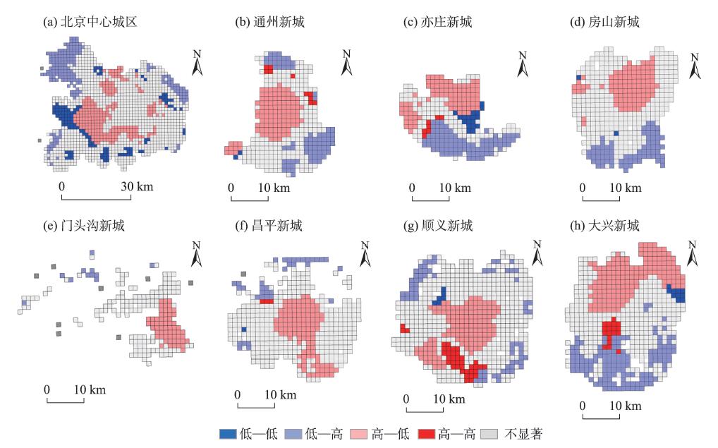
Residents' daily life circle is one of the key issues in relation to the national spatial planning in the "new era". Supply of public service facilities is the primary condition for plan-making of this type of circle. Spatial match between residents' daily life circle and public service facilities reveals the human-environment relationship at the community level. There exist many studies on spatial match between residents' daily life circle and public service facilities. However, the existing findings are mainly based on survey data, which have disadvantages such as insufficient samples, small geography coverage, and so on. This study investigated the spatial match between residents' daily life circle and public service facilities in large cities by taking Beijing as an example. Using mobile phone data and point-of-interest (POI) data collected in 2018, this study measured the spatial range of residents' daily life circle and accessibility of public service facilities, and analyzed the relationship between the spatial range of residents' daily life circle and accessibility of public service facilities by the bivariate spatial autocorrelation method. It also analyzed the geographical variations in the relationship. The results of analysis show that residents' daily life circle has a multi-centric structure at the city level. The length of radius of the circle increases from the central areas to the periphery. Accessibility of public service facilities is featured with a zonal structure but its level decreases with the distance away from the centers. The level of accessibility is negatively related with radius of the circle, which means that the higher level of accessibility, the smaller radius of the circle. There are geographical variations in the relationship. The relationship is "high-low" in the city center and new town centers, but dominated by "low-low" and "low-high" pattern in the fringe of the city center and new town centers. There are also variations in the relationship between different types of public service facilities. For the cultural and leisure facilities, the degree of spatial match between residents' daily life circle and public service facilities is obvious lower than other facilities. The conclusion of this research provides new evidence for residents' daily life circle study, and has policy implications for residents' daily life circle planning.
As the basic institutional arrangement for resource allocation and social integration in China during the era of planned economy, the danwei system played an important role in shaping the daily activity space and life circle structure of urban residents. However, currently studies on the relationship between the danwei system and life circle mostly focus on cities with a long history of planned economy and strong state-owned economy. Few studies have attempted to focus on the danwei system in emerging cities, although the danwei system practice existed in these cities. In addition, few studies have explained the formation and development of life circle from the perspective of public service facility supply mechanism. This study first analyzed the evolving role of the danwei system in the process of urban construction and development in Shenzhen City. Seven communities with features of danwei compounds, named as pan-danwei communities, together with one commercial housing community and one urban village community, were selected to depict the life circles of residents in these communities from the dimensions of spatial behavior and social relations. We believe that the path differences of the danwei system on the spatial and social practice that occurred in these communities have resulted in different community life circle structures and patterns. The life circle of these pan-danwei communities has similar features with the traditional danwei communities. These features include work-housing balance, self-contained amenity provision, and strong sense of community. On the other hand, because residents have no personal attachment to the danwei or the neighborhoods, they can make full use of various urban facilities to meet diverse demands. It provides a new model of reconstructing life circle in China, learning from the danwei communities. It is essential to encourage the development of various types of pan-danwei communities. Especially, various enterprise units or community developers should be supported to participate in the public good provision mechanism, and the construction mechanism of community life circles should be improved. Analyzing the localized practice of community life circles of this type of danwei compound can enrich the concept and construction models of community life circle in a market economy environment.
China is in a period of comprehensive transformation of economic and social developments. Urban development has shifted from expansion to focusing on the improvement of quality, and gradually began to focus on the quality of life of residents. Living space has become an important factor reflecting the quality of urban development. With the increasingly clear social class stratification and residential space differentiation in Shanghai, the complex background and multiple attributes of different residential areas shape a variety of living spaces, reflecting different life styles and quality of life. This study selected 253 typical residential areas as the research samples, and used mobile signaling data, supplemented by questionnaire survey data, to explore the structural pattern of living space of typical residential areas in Shanghai. Both the mobile signaling data and the questionnaire survey data were used to calculate the scope and boundary of daily activities, as well as the main nodes and channels of the activity network. It is found that the main center, subcenters, and other urban centers attract residents' daily activities and thus become nodes of the network; while rail transit makes activities extend and spread and become channels of activities by shortening travel time cost. The influence degree of urban centers and rail transit stations on residential areas can basically explain the spatial distribution of daily activities. Under the influence of these factors, 15 typical structural patterns have been formed. Among them, the main center has medium-strong influence, the subcenters have medium influence, and the structural mode of rail transit has the highest influence. Exploring the structure of living space in typical residential areas is of practical significance for the development of planning policies such as life circle construction, urban center system planning, and transportation facility construction.
In the new era of China's development, people's needs for living space have become diversified. At the community level, the transformation of the planning of a human-oriented community life circle needs to pay attention to residents' daily activities to use the community space, thereby reflecting residents' use of community public service facilities. This demands to identify the daily activity space of residents. However, current research has paid little attention to the differentiated spatial and temporal behavior characteristics of different types of residents, and cannot effectively respond to the diverse needs of community residents. Based on the theory of behavioral geography, this research proposed a method of using mobile phone signaling data to measure the core activity space and flexible activity space based on the frequency and density of residents' travel activities, and then analyze the characteristics of daily activities of different types of people. Taking Shazhou and Nanyuan streets in Nanjing City as examples, the daily activity space of adolescent, youth, middle-aged, and elderly resident groups in different communities was delineated, and the basic characteristics of residents'use of community space were analyzed from the perspective of daily activity range and vitality differences among groups. The research results show that the daily activity space of residents shows hierarchical, sharing, and directional features, and there are significant differences in the daily activity space of different age groups. Further, by using the correlation test to analyze the influencing factors of the vitality of different groups of the communities, we proposed a differentiated supply strategy for public service facilities that considers the activity space and facility needs of different groups. This research is helpful for improving the method of measuring the daily activity space of community based on the spatiotemporal behavior of residents, and enriching the understanding of the diverse behavior needs of community residents. The conclusions of the empirical research have certain guiding significance for the allocation of community public service facilities based on residents' diverse space and facility needs.
Family is an important context of individuals' everyday life. Solo and joint activity participation of family members is strongly affected by spatiotemporal constraints and resources. An extensive literature has focused on intra-household interaction and its impacts on households' daily activity patterns, but most studies are limited to aggregated time use and activity participation, and implicitly examine the interaction between family members. Using one-week GPS-based activity-travel diary dataset of three families in the Shangdi-Qinghe area of Beijing, this study applied the concept of project context in time geography to extend the study of household task division to a one-week period, to describe the characteristics and understand the strategies of household task division in suburban families. Spatiotemporal paths were used to describe and analyze solo and joint activity participation of family members. We found that working status, age of children, presence of extended family members, and ownership of private cars have complicated impacts on the allocation of household tasks, resulting in different patterns of allocation of household responsibility among family members. In this process, the dynamic transformation of constraints and resources reflects the construction and reconstruction of family local order, and routine-forming and routine-changing of individual behavior. To conclude, the introduction of family project helps to explicitly understand tasks and constraints of family members of suburban residents, and to provide sophisticated and nuanced planning and services.
Public service facilities (PSF) are the basic guarantee for urban production and living. Whether the distribution of public service facilities is equitable is related to the healthy development of cities and the society. At present, due to the lack of urban micro-scale population distribution data, there are few studies that consider both the supply side (PSF) and the demand side (population). In view of this, using the Internet maps application programming interface (API), this study established the 5-minute, 10-minute, and 15-minute community life circle of Lanzhou City, and then used Worldpop grid data, population census data, and Baidu heat map data to simulate the population distribution at high spatial resolution and with high accuracy. We evaluated the matching relationships between population and public service facilities in Lanzhou City. The study found that: 1) The matching relationships between different types of PSF and population are very different. However, they show a common phenomenon that the matching degree close to district administrative centers is often better than that of urban fringe. 2) In Lanzhou City, the matching relationships between PSFs and population are highly polarized, that is, there are more highly matched and mismatched life circles, and the number of moderately matched and relatively poorly matched life circles is fewer. 3) Based on the coverage of moderately and highly matched life circles, the coverage of all levels of travel, medical (except community health service centers corresponding to 10-minute life circle), dining, and entertainment facilities is the widest. The allocation of elderly care facilities at all levels and grass-roots cultural facilities is seriously inadequate, and other facilities are between the two types. The study concludes that the problems that have been identified need to be addressed. It suggests that urban planning should focus on the allocation of various PSF in the urban fringe, and improve the coverage of all levels of elderly care facilities.
Using export data of the China Customs Database from 2000 to 2016 and methods measuring path-dependent and path-creation new industries and technological complexity of industries, this study analyzed the regional industrial development paths of China. Four types of regional industrial development paths were identified based on technological relatedness and technological complexity dimensions. The results show that, first, Chinese exports have an increasing trend in spatial dispersion, moving from the core cities of the Pearl River Delta to the core cities of the Yangtze River Delta and Shandong Province, and then to the peripheral areas of the Yangtze River Delta, the provincial capital cities of the central and western regions, and Jiangxi Province. Second, regional industrial diversification shows a high level of path dependence. From 2000 to 2016, path-dependent new industries accounted for about 70% of the total, while the figure for path-creation new industries was about 30%. Developed areas in coastal regions and capital cities in the central and western regions showed more path-creation characteristics. Third, in terms of path-dependent new industries, a half of them have a higher technological complexity than their parent incumbent industries. Regarding path-creation new industries, roughly two thirds of them have a higher technological complexity than their corresponding city average. Fourth, coastal regions have more path-creation new industries with a higher technological complexity, while the central and western regions have more path-dependent new industries with lower technological complexity. The results indicate that the Chinese government should take measures to promote the development of path-creation new industries with a higher technological complexity in the central and western regions.
The financial crisis in 2008 had a great impact on the global manufacturing industry, especially on the industrial chains in the "world processing plant" Pearl River Delta region. In the context of the financial crisis, high-quality market demand and flexible production models have impacted the traditional production pattern of the Pearl River Delta. The closure of mass production enterprises has affected the relationship between industrial clusters in the Pearl River Delta. Based on the complex network theory of evolutionary economic geography, this study used the second National Economic Census databases of 2008 and the third National Economic Census databases of 2013 to map the manufacturing industry space network in Guangdong Province at the town and township scale. We analyzed the internal and external relationships of the five leading regional industrial groups. We also discussed their change in the industry space and finally took Beijiao Town of Foshan City as a case study. This study found that the internal industrial proximities within the leading industrial groups increased and the proximities between them decreased in the industry space network. It indicates that the region is beginning to grow out of local support and is more deeply integrated into the external production network, so as to enhance regional resilience and adapt to the new needs of the global market. This reveals that the industries have evolved from a relatively primary, diversified, and decentralized development to a high-end, specialized, and centralized industrial pattern. In the future, the Pearl River Delta urgently needs to transform and respond more quickly to the global market, and it is suggested that the region should not be confined to providing processing and manufacturing functions for developed countries, but strengthen local characteristic production brands and build a complete local industrial chain to achieve sustainable industrial development.
The fast-growing high-speed rail network has a deep impact on regional socioeconomic systems. This study used the external horizontal economic linkage data of the whole industry in Nanjing City from 2000 to 2019 to measure the change in the economic linkages between Nanjing and other cities. On the basis of revealing the connection patterns and changes between city-dyads, the study quantitatively identified and analyzed the heterogeneity of the impact of high-speed rail on city-dyads with different attributes. The results show that: 1) The strength of the connections between Nanjing and different cities across the country exhibits obvious hierarchical, regional distribution, and portal characteristics. 2) The difference in economic development level and the strength of the transportation connection between city-dyads are the key influencing factors of the strength of the connections. The development of high-speed rail strengthens the connections between city-dyads and to a certain extent aggravates the polarization of the geographical pattern of connections. 3) The high-speed rail shows obvious heterogeneity in the degree of impact on different types of city-dyads. City-dyads with short time distances, high degree of cooperation guided by government policies, large differences in GDP, and small differences in innovation capacity are more likely to benefit from the development of high-speed rail. According to the conclusions of this research, it is possible to intervene and guide specific cities to participate in the construction of urban networks. Under the influence of the high-speed rail, city-dyad may further directionally drive the flow of factors between cities.
The construction of healthy communities is an important trend in the post-pandemic era. While many studies have investigated the effects of single lifestyle behaviors on health, the minimization of the individual risk of disease might only be achieved by a combination of these behaviors.This paper uses the 2019 Beijing City Physical Examination questionnaire survey data to construct an evaluation index system for the healthy lifestyle behaviors of community residents. Based on this, we use the hierarchical linear model (HLM) to investigate the impact of community built environment on residents' lifestyle. Results from the HLM show that the differences between neighborhoods can explain 6.93% of the differences in residents' healthy lifestyle. And within the 500 m buffer zone of the community boundary, the built environment with a low degree of urban function mix, a well-developed public transportation system, and a high proximity to parks is more conducive for residents to form a healthy lifestyle. And from the perspective of community type, the healthy degree of lifestyle of residents in policyhousing communities is significantly lower than that of other communities, which is manifested in the low level of social communication and mental health. This study provides new ideas for the construction of healthy communities from the perspective of promoting a healthy lifestyle for community residents.
The impact of urban built environment on residents' travel behavior, especially car commuting, is a basic topic of traffic demand forecasting, which has received considerable research attention. Existing studies mainly focused on single trips and paid less attention to the collaborative decision making under the influence of trip chains. By using the logistic model and detailed activity diary data collected in Guangzhou City in 2017, this study investigated the relationship between urban built environment and car commuting on weekdays from the trip chain perspective. Empirical results indicate that there is an interactive relationship between non-commuting trip in the trip chain and the built environment of the workplace and residence, which synergistically affects residents' commuting modes. On the one hand, the non-commuting trip time (before or after the commuter's trip) make difference in the relationship between the built environment and commuting mode choice. On the other hand, the mutual influence of several built environment factors—residential area, work location, and non-commuting activity—determines the commuting behavior. Therefore, the extension of the results may provide new thoughts for predicting individual traffic behavior and traffic demand based on individual models.
Based on the daily temperature data of 37 stations in northern Xinjiang from 1961 to 2017 and elevation, 15 extreme temperature indices of 3 categories (cold indices, warm indices, and extreme indices) were selected to explore the possible impacts of geographical factors on long-term trends of extreme temperature indices over northern Xinjiang by means of correlation analysis and grey correlation degree. The results show that: 1) Climate warming is significant in northern Xinjiang, the extreme temperature cold indices show a very significant downward trend, and the warm and extreme indices show a significant or very significant upward trend; climate warming is mainly reflected in the decrease of extreme cold event frequency, and the rise of night temperature and extreme low temperature, which has the characteristics of asymmetry of daytime and nighttime changes and imbalance of low and high temperature changes. 2) The trends of extreme temperature indices in the central basin area of northern Xinjiang are the strongest, while relatively small in the mountainous areas. The influence of topography on the long-term trends of warm indices is greater than that of cold indices. Altitude has a great influence on the frequency of extreme temperature events. 3) The meridional distribution of the trends of extreme temperature indices is the dominant pattern of their spatial distribution. The tendency variations of extreme temperature indices in northern Xinjiang are greater in the north than in the south, and greater in the west than in the east. The biggest difference of tendency variation between the north and the south is in the central part of Northern Xinjiang, and the difference has a negative correlation with altitude, which indicates that latitude has little influence on the long-term trends of the extreme temperature indices in mountainous areas, while it is an important factor in the basin. In the meridional direction, the increasing trend of hot nights has a lower correlation with altitude, while the other indices have a higher correlation with latitude in the east than in the west of northern Xinjiang. 4) Geographical factors have significant influences on long-term trends of extreme temperature indices (the grey correlation degrees are greater than 0.6, which means a high correlation), and the influences of geographical factors on warm indices are greater than cold indices. The influences of geographical factors on the cold indices are stronger in the mountainous and hilly areas, while the influences on the warm indices are mainly manifested in the hilly and basin areas with relatively flat terrain.
To reveal the impact of urbanization on urban river systems, the Buji River Basin, a typical highly urbanized watershed in the Guangdong, Hong Kong and Macao Bay Area, was selected as the study area. Based on Landsat satellite images from 1988 to 2015, Google Earth high-resolution images from 2003 to 2017, the river system data in 2019, as well as literature on the river improvement projects of Shenzhen City since 1980, the characteristic indices of river channel change were constructed to evaluate the spatial and temporal evolution of the river in the process of urbanization using remote sensing data and GIS technology. The study shows that: 1) From 1988 to 2015, the land use/land cover types of the Buji River Basin changed dramatically, and the urbanization rate increased from 24.55% to 61.78%. Generally, the urbanization showed the spatial and temporal characteristics of "fast first, then slowed", "spreading from downstream to upstream", and "developing along the river then towards the periphery". With the development of urbanization, the improvement of the Buji River has gone through four stages: pre-improvement, flood control measures, flood control and ecological restoration measures, and dredging measures. 2) The spatial and temporal evolution of the river was affected by urbanization. The increase of population and GDP has a driving effect on the river channel change. Different urbanization processes in different places have had different impacts on the river system, and urbanization has had different impacts on the main stream and tributaries of the Buji River. 3) On the whole, from 2003 to 2017, the proportion of surface channel, bending coefficient of surface channel, and river surface rate of the Buji River decreased by 19.06%, 9.63%, and 1.79%, respectively, which were negatively correlated with urbanization level. The river bed hardening rate was positively correlated with urbanization level, with an increase of 6.47%. This study provides a reference and theoretical support for river improvement and flood control and disaster reduction in urbanized areas of China.
Nature reserves are the areas with the most abundant biodiversity. Conducting a survey of current forest biodiversity in Lushan Nature Reserve and understanding the distribution and changes of vegetation in the protected area is of great significance for the protection of forest resources in Lushan. In this study, we used the Proba-V satellite 100-meter resolution 5-day vegetation index product from 2015 to 2018 using the maximum synthesis and Hants time series harmonic analysis methods to smooth the data and reduce noise, and used a random forest algorithm to classify the forest vegetation. The changes of Lushan vegetation communities were also analyzed. The research results show that: 1) The overall accuracies of the random forest classification of Lushan forestland from 2015 to 2018 were 85%, 84.25%, 84.75%, and 85.25% while Kappa coefficients were 0.80, 0.79, 0.81, and 0.80, respectively. Compared with the Cover-CCI-2010, Globcover-2009, Globeland30, and MODIS-2010 land cover products, the classification results by random forest classifier based on time series NDVI products have achieved good classification effect and high classification accuracy in spatial resolution and mapping accuracy. 2) In Lushan Nature Reserve, coniferous forest and broad-leaved forest are concentrated while mixed forest and bamboo forest are scattered among them. Coniferous forest has the largest distribution area, accounting for 39.36% of the total forest area, and the bamboo forest has the smallest distribution area, accounting for 14.63%. 3) From 2015 to 2018, the spatial distribution of forest vegetation communities in Lushan did not change much. The change rates of broad-leaved forest, coniferous forest, and mixed forest were all less than 10%. Bamboo forest fluctuated during 2015-2018 because of the interference of human activities while the change of broad-leaved forest was the smallest.
Urban network research has become the frontier academic field of international urban research and has gradually become a hot spot. At present, the related literature on "urban network" mostly focuses on conceptual discussion, dimension analysis, and network structure analysis. Research on the influence of network on regional economic development is relatively weak. Externality, as an essential attribute of urban network, is of great significance to the evolution of urban network and the development of cities and regions. This article starts from a comparison of agglomeration externalities with urban network externalities, focusing on the review and evaluation of the formation mechanism, utility, and measurement methods of urban network externalities. The synergy effect, integration effect, and borrowing size are considered important reasons for the formation of urban network externalities. The research on the effectiveness of urban network externalities focuses on two aspects. The first is the role of factor flow in promoting knowledge diffusion and innovation, and the second is the impact of urban network on competitiveness and economic growth. Based on the existing literature, the research on the measurement of urban network externalities mainly involves identification and estimation, including three common methods: correlation analysis, regression analysis, and spatial econometric analysis. The existing empirical research on externalities is still mostly based on static analysis and lacks dynamic consideration. To a large extent, the existing research has insufficient theoretical framing and insufficient explanatory power, often resulting in the discovery of conditional associations, but not causal relationships. The Western research on urban network externalities is relatively early and mainly focuses on the global and regional dimensions, while Chinese scholars focus on the national and regional dimensions. In terms of empirical methods and objects, Chinese scholars have also made some innovations based on the study of world city network. The issues that need further attention in the future include theoretical understanding of urban network externalities, externality measurement methods, and empirical research.