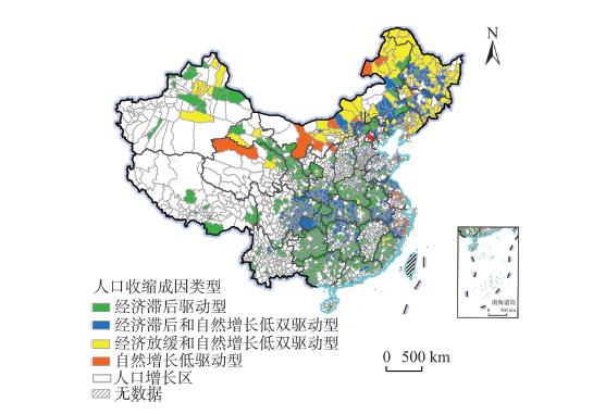
Regional population decline has gradually become a new phenomenon in recent years, which has attracted extensive attention from scholars and the government. Using the national census data and 1% population sampling survey data, this study identified the population decline areas at the county level from 1990 to 2015 from a multi-periodical perspective. Based on the theoretical analysis of the driving factors of population decline, a cluster analysis has been conducted to reveal the spatial differences of the driving factors of population decline, which resulted in four typical cases of causes. The findings are as follows: First, the population decline areas have very different trajectories: while about 24% of them are characterized by fluctuating but overall decline, about 13% of them have experienced continuous decline, and about 5% of them have only experienced recent decline. Second, the fluctuating but overall decline county units were mainly distributed in the middle reaches of the Yangtze River and Gansu, Shaanxi, Jiangsu, and Fujian Provinces, and the continuous decline county units were mainly concentrated in Sichuan, Guizhou, Chongqing, and the Northeast region, and the recent decline county units were mainly concentrated in the Northeast region, Henan, and Xinjiang. Third, there are obvious regional differences in the driving factors of population decline: the county units driven by lagged economy accounted for the highest percentage, and these units were mainly distributed in the central and western regions; the county units in the Northeast region were mainly driven by the slowed economic development and the low natural growth level; in contrast, the percentage of county units only driven by the low natural growth level is relatively low, and these units were mainly distributed in the eastern region. Based on these findings, we argue that it is necessary to pay more attention to the phenomenon of population decline at the regional scale, and take targeted measures by fully considering the trend of change and driving factors of population decline in different regions.
In order to grasp the specific consumption path of water resources in the production chain and the role played by each department in the consumption path, as well as grasp the key departments that maintain water consumption in the production chain, this study used input-output models and structural path analysis to analyze the total amount and structure of water consumption in 42 sectors of China and the specific path of water consumption in the production chain based on the 2017 input-output table and related meteorological data, and adding green water consumption to agricultural water use. In this way, we can grasp the specific consumption path of water resources in the production chain and the role played by each department in the consumption path, as well as grasp the key departments that maintain water consumption in the production chain. The results show: 1) Urban residents consume and import are the sectors with the highest water footprint, followed by rural residents. Most sectors with higher water footprints are dominated by residential consumption. Imported water resources make up for the consumption of some domestic production water, but the situation of water shortage is still severe. 2) The water footprint consumption ratio of the first five levels of the production chain is about 95%, of which intra-sectoral consumption ratio is the largest. Water footprint decreases with the increase of the number of levels, and the degree of water resource cycling is weak. 3) With regard to the production chain of sectors, intra-sectoral water footprint accounts for the largest proportion, the difference between the water footprint of sectoral inflow and outflow is large, one-way dependence between sectors is common, and the association network is not stable. 4) From the perspective of final consumption, the internal water footprint of the agricultural sector has the largest proportion, and is an important connection point in the production chain. Diversified consumer demand increases the pressure on water resources in upstream sectors. The study provides a theoretical basis for adjusting water-saving policies and improving water resources allocation and management capabilities.
Inclusive green development aims to ensure sustainable economic growth while promoting social equity and resource and environmental improvement. It is an inevitable choice for building ecological civilization and improving people's livelihood. This study constructed an evaluation system of inclusive green efficiency, and used the Super-Epsilon-Based Measure (EBM) model considering the undesirable outputs to comprehensively measure China's inclusive green efficiency. On this basis, spatial autocorrelation analysis was used to analyze the spatiotemporal characteristics of inclusive green efficiency. By using a spatial Durbin model, the spatial spillover effects and influencing factors were analyzed. The results show that: 1) From 2000 to 2017, China's comprehensive inclusive green efficiency and scale efficiency fluctuated slowly, and the pure technical efficiency showed a "V-shaped" trend. The improvement of comprehensive efficiency gradually changed from scale effect to technology driven. 2) The spatial pattern of inclusive green efficiency in China has evolved from low-level equilibrium to high-level imbalance. The high-value areas are concentrated to the east of the Hu Huanyong Line, while the low-value areas are mainly in the northwestern, southwestern, and northeastern areas. Comprehensive efficiency and pure technical efficiency form three high-value areas in Beijing-Tianjin, the Yangtze River Delta, and the Pearl River Delta at the national level, and the high-value areas of scale efficiency show a "H" shape. 3) The same type of inclusive green efficiency shows the characteristics of spatial agglomeration, which is also continuously enhanced. The hotspots tend to move to the northeast. The hotspots are gradually stabilized in the Yangtze River Delta region, and the secondary hotspots are mainly in the Beijing-Tianjin and Pearl River Delta regions. The northwest, southwest, and northeast are basically cold spots. 4) The regression results of spatial Durbin model show that there is a positive spatial spillover effect of comprehensive inclusive green efficiency and its components. Economic development level, industrial structure, industrialization, government administrative ability, fiscal decentralization, environmental regulation, scientific and technological innovation, and marketization have significant influences on inclusive green efficiency, among which government administrative ability, fiscal decentralization, environmental regulation, scientific and technological innovation, and marketization have some spillover effects. Finally, some related policies, such as strengthening inter-regional exchanges and cooperation, accelerating the optimization and upgrading of industrial structure, optimizing the government's fiscal expenditure structure, promoting the transformation and application of scientific and technological achievements, and letting the market play a decisive role in the allocation of resources, were put forward based on the empirical analysis. This study provides a new perspective than the traditional assessment of economic efficiency, and the conclusions can provide some reference for China's ecological civilization construction and green transformation development.
Imports can bring new knowledge to a region, and the spillovers of this kind of knowledge show multi-scalar characteristics. This article held the view that imported knowledge can first show a spillover effect within the firms, and then cross firms' borders to have a spillover effect within the regions through inter-firm linkages. Firms can achieve the evolution of export products by searching for imported knowledge within firms as well as within the regions. Based on this theory, this article established a multi-scalar research framework of knowledge spillovers, and used the data of China Customs Trade Statistics from 2002 to 2016 to confirm the existence of the above phenomenon. The results show that on the one hand, for the evolution of export products, the effects of intra-firm and intra-region spillovers are mutually substituted. On the other hand, the knowledge spillovers show the characteristics of distance attenuation. The results of sub-sample regression show that in regions with higher marketization levels, intra-region knowledge spillovers are more effective for the evolution of firms' export products, and firms prefer to "learning from others" in order to achieve the goal of exporting more products, while in regions with lower marketization levels, firms rely more on intra-firm spillovers, which can be called "learning from yourself". To some extent, this article enriches the discussion of knowledge spillovers at different scales and their interrelationships, and improves the cognition of the mechanisms of firms' export products evolution, which is of certain academic and practical contributions.
With the implementation of the "mass entrepreneurship and innovation" strategy, China has entered a golden era of entrepreneurship. As one of the most important innovations, Internet has increasingly become a new driver of regional competitive advantage. Drawing on a unique dataset of Chinese Internet firms during 1994-2019, this study investigated the spatiotemporal dynamics and survival determinants of startups in China by the spatial econometric and survival analysis methods (Kaplan-Meier method and time-dependent Cox regression model). We found that: 1) The number of Internet startups in China reached a high speed of increase during the past 25 years. It grew slowly in the early stage and then rose sharply around 2015, showing a "S-shaped" trend. The survival time of Internet firms across four cohorts is significantly different—those who entered earlier usually have a longer survival time. It is common that new firms face a high survival risk regardless of cohorts, because they are not strong enough to compete with the big companies and resist various risks. 2) The spatial pattern of Internet firm survival varies significantly among regions. There is an obvious urban preference in the existing numbers. Regions with long firm survival time are mainly located in the eastern areas of China, which enjoy a high level of economic development and population concentration. However, with the industrial development and increasing number of entries, both the regional resource advantage and competition pressure of the eastern region have become greater. As a result, the survival advantage of the central areas of China starts to appear. 3) In terms of survival determinants, firm heterogeneity, cohort, and entrepreneurial environment all show significant effects. Among the firm features, larger scale and higher investment rounds usually have a stable protective effect and would reduce the survival risk remarkably. At the cohort level, the average survival time of the early-entering startups is significantly higher, and favorable entrepreneurial environment imposes survival risk as a whole mainly because of the competition effect. 4) While the incubation environment changes from incentive effect to competitive effect over cohorts, the protection effect of firm scale and life cycle, as well as Internet infrastructure, gradually weakens. This study could provide empirical support for the longitudinal development of Chinese Internet innovation and entrepreneurship wave, as well as an interesting case study for the geography of entrepreneurship.
Since the marketization of China's housing system, urban residents' housing adjustment through making residential moves has become relatively frequent. Residential mobility, as the micro-mechanism of urban space differentiation and restructuring, has been extensively studied in urban geography and housing studies. However, the existing literature mainly focuses on the motivation underlying residential mobility and its impacts on individuals/families and urban space. Comparatively, the location changes before and after residential moves have received scant attention in previous studies. This study adopted the perspective of life course and time geography to depict the residential trajectories of Shanghai residents and explore the influencing factors of location choice in residential mobility. The data used for the empirical analysis were drawn from the 2018 "Shanghai Resident Housing and Living Space Survey", which adopted the stratified and multi-stage probability proportion to size sampling. A retrospective survey was conducted, allowing us to obtain information on the respondents' sociodemographic information and their residential trajectories. The results reveal that the dominant type of location change is outward move across the ring roads. Nevertheless, the variations in location choice between cohorts, local population and migrants, and renters and owners of properties are evident. Compared with the older cohorts, younger cohorts generally make residential moves at earlier ages, and many of them move from the central areas to the suburbs. Different from the local population, migrants' residential mobility is more constrained in terms of the timing of making residential moves and their location choice. Furthermore, this study shows that age, location of workplace, and housing tenure all significantly affect location choice in making residential moves. Specifically, the older cohorts concentrate in the central areas before as well as after a residential move. Commuting distance plays a major role in affecting people's choice of residential location, and owning an automobile has insignificant influence. A transition into homeownership is often associated with a change to an advantageous location.
Understanding the regularity and randomness of residents' daily activities is fundamental for spatial behavior studies when the focus is turned from description to prediction. In this study, behavioral regularity was explored from multiple aspects based on individual spatiotemporal trajectories, which were extracted from 10 working days' mobile signaling data in Shanghai Municipality. First, spatiotemporal behavior was recognized as four modes—non-trips, random trips only, regular commutes, and other regular trips—based on periodical recurrency and time series connection. The latter two modes with strong regularity account for 49.3% in population, 83.6% in trip generations, and 82.0% in trip distance. Second, entropies of trajectories were calculated at the individual level, from which a 0.84 potential predictability of locations could be inferred. All these findings arrive at a conclusion that residents' spatiotemporal behavior in working days is strongly regular. Furthermore, the article discussed the spatial heterogeneity of behavioral modes and predictability of locations, including characteristics of spatial distributions, as well as underlying influencing factors from the environment.
Under the dual impact of industrialization and urbanization, the built environment and social environment of local communities have changed dramatically. With the increasing pursuit of a high-quality residential environment, green space as a kind of scarce spatial resource can buffer the adverse environmental conditions and promote physical activity and social contact, and therefore exert an important influence on residents' place attachment to neighborhoods. Additionally, with the profound reform in the housing market, the heterogeneity of green space between gated neighborhoods and non-gated neighborhoods has become more prominent and attracts increasing attention. The association between green space and place attachment deserves an in-depth exploration. Using the data collected from a questionnaire survey conducted in 2015 from 23 Guangzhou neighborhoods and a multilevel linear model, this study explored the effect of urban green space on residents' place attachment, paying particular attention to the mediating role of residents' satisfaction with their living environment. The green space rate for each case neighborhood was extracted from the "Quick Bird-2" high-resolution remote sensing image data. The second focus of this study is on the difference between the gated neighborhoods and the non-gated neighborhoods with respect to the effect of urban green space. Our empirical findings suggest that: 1) Green space rate can directly enhance residents' place attachment to a neighborhood. 2) Residents' satisfaction with the living environment can mediate the relationship between green space rate and place attachment. 3) For the gated neighborhoods, residents' satisfaction with the living environment is a partial mediator—it partially explains the association between green space rate and residents' place attachment and indirectly promotes residents' place attachment. 4) For the non-gated neighborhoods, the association between green space rate and residents' place attachment can be fully explained by residents' satisfaction with the living environment. Based on these empirical results, this article suggests that the government should pay attention not only to the spatial distribution and the accessibility of green space, but also to residents' right of entering and using green space, their experience and feelings, and their subjective satisfaction with the living environment. In recent years, market forces such as the real estate developers have provided neighborhood services and resources for their residents, relieving the pressure on the government to maintain public goods and services. Through setting up boundaries, the gated neighborhoods can effectively guarantee residents' right to use green space and avoid the problem of free riding. But meanwhile, it has also enlarged the problem of inequality on green space use and therefore has led to the differences in place attachment between the gated neighborhoods and the non-gated neighborhoods. The right of using and entering green space becomes especially important—the territoriality and exclusiveness provided by the boundary of the gated neighborhoods can strongly arouse residents' sense of territory, and thus promote their place attachment. These conclusions can provide inspirations for optimizing local governments' neighborhood governance and urban planning policy. The municipal government should give priority to the vulnerable groups and reallocate public resources to improve subjective well-being and place attachment of all citizens.
Under the institutional background of China, the development of rural tourism is closely related to the change of policies. In this study, the dynamic mechanism of rural tourism policy change was explored by using the clear set qualitative comparative analysis method of multivariable interactions. This method emphasizes that through the continuous dialogue of empirical data and relevant theories, the possible causality of the research target can be mapped out from small and medium sample data. This method was used due to the following considerations: First, the main feature of the clear set qualitative comparative analysis method is its treatment of dichotomous variables, especially phenomena "occurring" and "not occurring", thus it is suitable for examining whether there is a change in policy in this study. Second, the core of the qualitative comparative analysis method of clear set is not to consider each condition variable as an independent variable, but to consider it in combination with other variables in different ways. The results of rural tourism policy change in Huangshan depend on different influencing factors at the same time and the use of clear set qualitative comparative analysis method can discover multiple pathways with equivalent results. Third, the relationship between the single factors causing Huangshan rural tourism policy change is not symmetrical and the clear set qualitative comparative analysis method is useful for such analysis. Fourth, the use of qualitative comparative analysis method of clear set can find out multiple pathways with equivalent results. This method can compare different cases in the same area, explore the combination of antecedent conditions in accordance with the theoretical logic, and establish the causal relationship between various combinations of conditions and the interpreted results. Based on the above, this research explored the configuration of the impact of rural tourism policy change, which is composed of organization/leadership change, rural planning policy change, local cultural policy change, host resident participation, and tourism market public opinion. The results show that: 1) Among the individual factors, the change of organization/leadership has a greater influence on the tourism policies at the level of tourism bureau and the participation of host residents has a greater influence on the policies at the city level, but all individual factors are not sufficient for the change of rural tourism policies. 2) Among the 32 alternative path combinations, there are four specific combination pathways with sufficient conditions that affect the changes of rural tourism policies at the municipal level, and there are three specific combination pathways with sufficient conditions that affect the changes of rural tourism policies at the tourism bureau level. 3) For the change of tourism policies at the municipal level, the change of rural planning policy, public opinion of tourism market, and the participation of host residents have similar degrees of influence, and the influence of leadership change of the tourism department is relatively small. 4) For the change of policies at the level of tourism bureau, the change of organization and leadership, the change of rural planning policy, and the change of cultural policy have similar degrees of influence, and host resident participation and public opinion of tourism market have less influence in this pathway.
Since the implementation of the targeted poverty alleviation strategy, rural poor population measured by the income standard has declined significantly, but rural poverty has multidimensional and dynamic characteristics. It is of great significance to carry out research on the dynamic change of rural poverty for its effective governance in the new era. Based on the data of fixed observation points in rural areas of Henan Province from 2010 to 2018, this study constructed a multidimensional poverty evaluation index system for rural households from three dimensions—income, living conditions, and education—and used Markov Transition Probability Matrix and Panel Logit Model to make an empirical analysis on poverty type transfer and the influencing factors of households falling into poverty. The results show that: 1) Multidimensional poverty is more accurate than single-dimensional poverty, especially income poverty, in reflecting the state of rural poverty. 2) The gap between the incidence of single-dimensional poverty and multidimensional poverty is widening from 2010 to 2018, which is largely related to the rise of the incidence of education poverty, and the decline of education-living condition poverty, income-education poverty, and three-dimensional poverty. 3) Single-dimensional poor households are more likely to turn into education poverty households, and multidimensional poor households are more likely to turn into education and living condition poverty. 4) The occurrence of rural household poverty is the result of the interaction of the characteristics of household head, family, and village, but the influencing factors of different types of poverty are significantly different. Compared with the occurrence of single-dimensional poverty, the occurrence of multidimensional poverty is significantly affected by fewer factors, and the influence of each factor is greater. The above conclusion indicates that along with the shift of focus of poverty alleviation in the new era to multidimensional poverty, specific poverty alleviation measures should be formulated according to the types of poverty, especially with a focus on the provision of public services such as education.
The southeastern Tibetan Plateau is high in elevation, with complex terrain and high cloud cover. It is very important to understand the characteristics of the snow cover distribution in this area for railway snow disaster prevention. Based on 35 GF-1 images during the snow accumulation period from 2013 to 2019, 2 m-resolution images were obtained by fusing panchromatic band and multispectral bands. Characteristics of the spatial distribution of snow cover within study area were obtained by visual interpretation. Combined with the modified 30 m-resolution SRTM DEM, the influence of topography on the distribution of snow cover was analyzed. The proportion of snow pixel in the study area is 33.1%. The vertical characteristics of snow cover are obvious. Snow cover is concentrated in the elevation zone of 4000-5000 m (high altitude), accounting for 18.1% of the total snow cover area. The distribution ratio of snow cover on the north slope and northeast slope is higher, which is more than 15%, and the distribution ratio of snow cover on the south slope, west slope, southwest slope and southeast slope is lower, which is all about 10%. The comparison between the snow cover distribution obtained based on GF-1 images and the snow distribution proportion (MODIS fractional snow cover, FSC), and the snow cover distribution calculated based on the MODISV6 snow cover product (MODIS snow cover) obtained on the same day suggests that for the absolute error, 64.4% of MODIS FSC snow pixels are less than 10%, the producer accuracy and user accuracy of MODIS snow distribution products snow pixels are 33.8% and 32.7%, respectively, which indicates that the accuracy of MODIS snow products is relative low in the areas on the study area, and it is more pronounced with low snow coverage. The results indicate that when using MODIS snow cover products to study the temporal and spatial variation characteristics of snow cover in the study area, it is necessary to improve the retrieval algorithm of snow cover and to strengthen ground observations and snow cover research based on multi-source remote sensing data. This study provides support for snow and ice disaster prevention in the southeast Tibetan Plateau.
The long-term supply-demand imbalance of rural land use functions (RLUFs) is one of the main reasons for rural issues in China. Based on the multifunctionality theory, this study explained the mutual relationship between rural land consolidation (RLC) and rural vitalization with a focus on supply-demand and element-structure-function relationships, and then discussed how to realize the supply-demand balance of RLUFs through RLC so as to promote sustainable rural development. The results show that: 1) Comprehensive rural land consolidation is a multifunctional land use method and an important means to solve rural issues for promoting rural vitalization. In essence, it is the transition from productivism that focuses on economic benefits to non-productivism that takes social, economic, and environmental benefits as a whole. 2) RLUFs include production, living, ecological, and cultural functions, corresponding to the economic, social, enviromental, and cultural demands of rural vitalization. The production functions are divided into agricultural, commercial, and industrial functions, and living functions include residential, employment, and public service functions. 3) Along the path of integrating land use elements, restructuring land use structures, and optimizing land use functions, RLC promotes the supply-demand balance of RLUFs from the supply side according to local conditions. 4) In future research, the mechanisms and modes of RLC impact on rural vitalization at different spatial scales, as well as quantitative analysis of the functional supply of land use and the functional demand of rural vitalization under the influence of RLC should be given more attention, thus laying a scientific foundation for the formulation and implementation of land use and rural vitalization planning.
Sustainability transitions focus on the fundamental transformation of the existing socio-technical system towards a more sustainable mode of production and consumption. Emerged in Europe two decades ago, this new research field has already exerted impacts on the green transition policy practices of many countries and regions. In recent years, transition studies have increasingly taken geography into account, resulting in a new paradigm of geography of sustainability transitions. This emerging paradigm focuses on the role of spatial embeddedness and multi-scalar interactions in explaining where transitions take place. This article provides a critical overview of the development in the geography of sustainability transitions research, and suggests five promising avenues for future transition research in the Chinese context: 1) to develop concepts and theorize from the Chinese context; 2) to link sustainability transitions with latecomer regions' industry catch-up; 3) to compare the sustainability transitions in cities with different leading industries; 4) to pay more attention to the role of local agency through the lens of multi-scalar interactions; and 5) to explore the impact of digitalization and artificial intelligence on sustainability transitions.
New state space (NSS) framework is the main theoretical framework to explain urban and regional spatial transformation under the background of globalization. Researchers in China have introduced NSS to interpret China's spatial reconfiguration process in recent years. This study reviewed the background, key concepts, main ideas, and research findings of NSS in China and internationally, revealing that NSS can provide a unified perspective to analyze global spatial transformation. However, some defects of NSS would lead to serious ontological problems. First, the concepts of NSS have a tendency of generalization, meanwhile, are lack of falsifiability; second, the lack of flexibility of the framework is hard to capture multifaceted situations; third, NSS may complicate the real-world scenarios sometimes, which would go against the intention of theorization. China has unique national spatial administrative structures, governmental relationship, property right arrangement, promotion system of officials, and market economy development path, therefore NSS may run into difficulties to articulate the intricate Chinese contexts because it was proposed based on the background of Western scenarios. That is to say, there are limitations in using NSS to interpret China's spatial transformation—the differences of territorial administrative framework between China and Western countries may lead to correspondence problems of terms and concepts. Different property right arrangement could result in different dimensions of analysis in spatial restructuring. Finally, the complicated power field in China would have different internal driving forces in the process of regional and urban transformation. These problems would result in dilemmas when discussing and exploring the multiple-scalar practical situations and the underlying logic of state spatial transformation. Further, it would be difficult for Chinese academia to engage in in-depth academic exchanges with scholars from other countries, and to have their voice heard in the theoretical study of Chinese spatial transformation. The NSS might be caught in the involution of dogmatization and instrumentalization if it could not concentrate on several core topics related to the ontology of human geography. China is large and complex in territorial areas with multifarious populations, resources, environment, and so on. The special history and development contexts mean that any theories or frameworks would need to be examined in real and practical situations. Therefore, it is urgent to pay more attention to the localization of spatial transformation and governance theories and propose more universal theoretical frameworks to underpin the study of spatial transformation since 1978.
In the new era, oil and gas are still the core contents of energy power games, the attributes of energy power are very different, and the connotation of energy security and energy strategy has also changed. Based on a systematic review of energy geopolitics, this study put forward the concept of energy power, and found that the global energy situation is undergoing profound changes. Instead of taking the "oil power" generated by the possession and production rights of fossil energy as the only core, global energy research has expanded to multi-dimensional energy power, and the power connection has expanded from competition and cooperation to the complex energy network relationship. The research elaborated specifically from four aspects: geopolitical pattern, energy security concept, energy network, and global energy governance: 1) The core of traditional energy geopolitical research is energy distribution, spatial change of production and marketing, and their patterns, and the imbalance of oil and gas resources geographic distribution is the most direct factor of energy power generation. 2) From the oil crisis era with supply security as the core, to the collective action formed around energy interdependence, and the new order of global energy governance in the new energy era in the future, the different views of energy security are the important factor leading to the change of international energy geopolitical power. 3) Energy as commodity and the geographical attributes of energy determine that energy trade is not only an economic behavior, but also closely related to international politics. The separation of production and consumption makes trade control and channel control in the secondary distribution of oil and gas an important influencing factor on the reconstruction of energy power. 4) The change of global energy power and complex energy power network will lead to a new order of global energy governance system. The main holders of power have changed from countries, international organizations, and multinational companies to communities of interest in the global energy network. The theme of energy governance has changed from the interests of countries to the redistribution process of global energy power. In future studies, academic research of energy geopolitics should focus on the following issues: how to construct a new theory of multi-dimensional energy power system; how to evaluate the influence of new factors such as climate change and renewable and sustainable energy development; how to understand the inter-relationship between energy power and geographic space under globalization; how to reconstruct the order of global energy power and simulate its effect, and how to clarify the new energy governance mechanism and governance patterns. These themes are important energy geopolitics research propositions, and are of great significant for understanding and predicting the future energy situation and change in energy strategies.