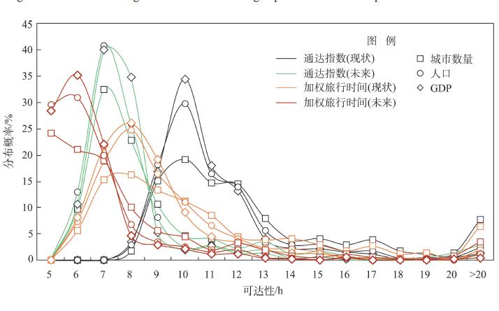
With the increasing emphasis on coordinated regional development, transport and socioeconomic developments in China have taken a new turn in recent years. Based on the present and future integrated land transport network, the trend of city network accessibility and its impact on the change of regional development patterns in China were analyzed in this study by focusing on the construction of travel circles and regional balance. The results show that the completion of the existing planning can greatly improve the accessibility of China's city network and can largely support the construction of travel circles according to the shortest travel time. By promoting the development of hub-spoke organization mode and spatial cascading order, the existing planning can guide the multi-center and networking development of spatial structure and provide a basis for the coordinated and balanced development between regions. In the future, China's transport development should continue to optimize the supply structure of transportation services and improve the ability of the integrated transport system to serve the needs of people's daily lives and production.
Since China joined the World Trade Organization (WTO), export trade has developed rapidly. From the perspective of export entities, domestic enterprises' export is particularly important for regional economic growth and the improvement of China's economic strength. Establishing inter-regional linkages and utilizing external resources can effectively promote the overseas market expansion of domestic enterprises. Based on the import and export data of Chinese customs database from 2001 to 2011, the spillover effect of external knowledge environments on the development of new export market of domestic enterprises of prefecture-level cities was examined by a conditional logistic regression model. This study distinguished three external knowledge environments that affect the overseas market expansion of domestic companies. Domestic companies can: obtain external knowledge from foreign invested companies in the same region; form cross-regional contacts with companies in neighboring areas and obtain external knowledge; and acquire external knowledge by importing from other countries. By comparing the effects of the three external knowledge environments on the development of new export markets by domestic enterprises at the prefecture-level city scale, this study found that: 1) All three external knowledge environments have positive effects on domestic enterprises in their effort to explore new export markets. Local foreign invested enterprises have the largest spillover effects on exports, followed by the spillover effect of local enterprises' imports, and the effect of export enterprises in neighboring cities is the smallest. 2) In the central, western, and northeastern parts of China, the spillover effect of enterprises in neighboring cities is the largest and the spillover effects of all three external knowledge environments are significantly stronger than those in the eastern regions. 3) The spillover of exports from local foreign invested enterprises and enterprises in neighboring cities is stronger on high-tech products than on low-tech products.
Assessing the characteristics of landscape multifunctionality change in rapidly urbanized areas is critical for understanding resource allocation and optimization under the background of rural-urban development and transformation and for formulating reasonable regional land management and planning policies. This study took Suzhou City, the most prominent representative city in the urbanization process in the Yangtze River Delta Economic Zone, as the research area. Six landscape multifunctionality indicators are selected, including residential support, food supply, habitat maintenance, water conservation, climate regulation, and soil retention. Based on the 1 km landscape units, change in hotspots of regional landscape multifunctionality and trade-off co-evolution relationships were analyzed through spatial analysis, self-organizing feature maps (SOFM) network model, and other methods. The research shows that: 1) Affected by urban expansion, landscape multifunctions in Suzhou during 2000-2015 were dominated by the spread of residential support functions. Other landscape functions represented a differentiated shrinking trend, of which the function of food supply and habitat maintenance was weakened most significantly, and the spatial distribution characteristics of the three regulatory functions were consistent. 2) Landscape multifunctionality in Suzhou has gradually increased over time, and its high-value (>2) areas are concentrated in forest, grassland, and farmland areas. The spatiotemporal change of regional landscape multifunctionality varied from strong to weak and gradually stabilized under the influence of socioeconomic development, the hotspots of change were mainly distributed in rural areas and rural-urban junctions, and the cold spots are mainly based on ecological spatial agglomerations. 3) Trade-off relationships between landscape multifunctions during the study period did not change over time, but there is a volatile change in trade-off degrees. Combining the features of multifunctional trade-offs and the changing pattern of multifunctionality hotspots, Suzhou City can be divided into eight types of dominant landscape functions and four types of rural-urban development zones in landscape units and township administrative units. Overall, the advantages of landscape multifunctionality in rapidly urbanized areas of the Yangtze River Delta present a circular spatial migration process of "city → near suburbs → far suburbs → rural areas". However, land use diversifications mapped out by the multifunctionality will inevitably lead to more land use conflicts. Policymakers should consider the design and implementation of landscape management or land use policies from a multi-scale spatiotemporal coupling perspective.
Taking the Yangtze River Delta as the research object, this study established the correlation model and coupling degree model for evaluating the mechanism of interaction between urban land expansion and ecological environment effects by using grey correlation analysis method. It explored the pattern of temporal and spatial variation and coupling degree characteristics of urban land expansion and ecological environment effects and change, and analyzed the interactions between the two systems. The results show that: 1) The index of urban land expansion in the Yangtze River Delta has been increasing, and the socioeconomic development and land use development have played a significant positive role. Socioeconomic development imposes a demand for greater urban production and living space and higher environmental quality. The increase of construction land area, the high-intensity expansion and the decrease of population density are all important reasons for the increase of urban land expansion index. 2) The overall performance of the regional ecological environment quality is stable, and the ecological environment effect is reflected in its spatial differentiation, with obvious characteristics of spatial and temporal change. The ecological environment quality of the cities in Zhejiang Province is significantly higher than that of Shanghai Municipality and Jiangsu Province, which is closely related to the regional environmental carrying capacity, the construction of pollution control facilities, and the propagation of ecological protection concepts. 3) Most cities have low coupling degree between urban land expansion and ecological environment effect, and the relationship between the two systems is in a state of imbalance. In the process of urbanization, land expansion tends to be low-density and decentralized, which strongly threatens the ecological security and environmental quality and lead to the increase of spatial disparity between urban land development and ecological environment protection. 4) There is a strong interaction between the elements of urban land expansion system and ecological environment system in the Yangtze River Delta, and the forces of each element are slightly different. The stressing effect of urban land expansion on ecological environment is gradually increasing, while the restraining effect of ecological environment on urban land expansion is decreasing.
Achieving sustainable poverty alleviation and establishing a prevention and control mechanism for return-to-poverty in extreme poverty rural areas is a realistic requirement in the post-2020 era. It is also a key link between precision poverty alleviation and rural revitalization. Taking Chengkou County of Chongqing Municipality—an area of strong ecological fragility and concentrated continuous poverty—as the research area, and based on the poverty alleviation sustainability measurement model, obstacle degree model, and minimum variance model, this study explored the spatial differentiation of multidimensional poverty alleviation sustainability and the return-to-poverty risk models for 60 villages and 1950 farming households in the area. The study found that: 1) The sample villages' poverty alleviation sustainability distribution generally showed a "gourd-like" structure where the front end is narrow and the middle part protrudes. The multidimensional poverty alleviation sustainability in the area is generally low and of different degrees. 2) The return-to-poverty risk in Chengkou County can be divided into four models and 11 types, dominated by diversified integration of various resistance factors. Human capital, development opportunities, and other factors related to sustainable income growth, dynamic anti-risk capability, and endogenous drives of farmers have gradually become the focus of poverty reduction and control of return-to-poverty at this stage. 3) Local governments should give equal priority to alleviating poverty, improving the sustainability of poverty alleviation, and preventing return-to-poverty. At the same time, improve people's ability to resist risks and develop a network for preventing return-to-poverty of vulnerable groups with specific policy in each village.
Under the pressure of rural population and land-use change, the building of resilience has become an effective measure to ensure the sustainable development of regional social-ecological systems. Taking Gaoqu Township in Mizhi County of Shaanxi Province as the research area and using entropy weight TOPSIS method, this research measured the community resilience of 20 villages in the loess hilly-gully region from four dimensions of society, economy, institution, and ecology. The spatiotemporal change of community resilience from 2015 to 2019 was discussed; the impact mechanism of key influencing factors of community resilience was analyzed by using the obstacle degree model, and the dimensions of the current key factors were compared to divide the case study communities into different types for differentiated governance. The results show that: First, community resilience increased from 0.171 to 0.318 during the research period. Economic resilience increased significantly, institutional and ecological resilience increased only slightly, while social resilience decreased. The spatial variation of community resilience became more significant and shows a distribution pattern of "high in the middle and low in the peripheries". Second, the key influencing factors of community resilience at the end of the research period include the development level of animal husbandry and cropping, the number of farming households participated in agricultural industrialization, and per capita income of farmers in the economic dimension; the average years of education of local leaders, fairness in governance, and farmers' opportunity of participating in decision making in the institutional dimension; the proportion of rural public space and the proportion of migrant population in the social dimension; and the proportion of the area of irrigated land, terrace, and dammed land in the ecological dimension. Third, according to the obstacle degree ranking of the dimensions of the key influencing factors, the low-value communities of economic, institutional, social, and ecological resilience are identified successively. Finally, the 20 rural communities in Gaoqu were divided into three types, and corresponding countermeasures and suggestions were put forward according to the characteristics of the different types of rural communities, aiming to provide a reference for the decision making of precision and differentiated management.
Settlement pattern, an important part of the human-nature system, is the foundation of rural geography, and it has become a hotspot in geographic research. Scientific analysis and characterization of settlement patterns are significant for promoting the development of urbanization, ethnic unity, and well-off society in rural minority areas. However, there is still a lack of research on the settlement patterns of ethnic minority areas, especially in those multi-ethnic group gathered areas. This study depicted the settlement patterns of seven ethnic minority groups (including Hani, Yi, Zhuang, Han, Miao, Yao, and Dai) in the Hani Rice Terraces World Heritage area, which is a typical multi-ethnic group gathered area in the southwest of China. The results show that: 1) In terms of spatial locations, 68% of the settlements in the Hani terraced fields area are located in the west and central parts of the territory, mainly in the areas of Han, Yi, and Zhuang. 2) The ethnic settlement pattern in the Hani terraced fields is characterized by the mix of Hani-Yi, accompanied by the mix of other ethnic groups. 3) In terms of location and the environment, settlements of the seven ethnic groups have significant differences in locational and environmental characteristics such as altitude, slope, temperature, precipitation, distance to river, settlement scale, cultivated land area, distance to administrative center, and grain yields. 4) The main controlling factors of the distribution of Zhuang, Miao, and Yao settlements are economic and administrative and distance to tourism centers (86.4%, 75.3%, and 92.8%); the main controlling factor of the distribution of Yi settlements are air temperature (52.0%); and the main controlling factors of the distribution of Han, Hani, and Dai settlements are precipitation (98.7%, 52.2%, and 97.0%). 5) On the whole, the settlements of Hani terraced fields formed a three-dimensional pattern of multi-ethnic symbiosis vertically, and a multi-ethnic mosaic pattern horizontally. This research can provide a reference for the construction of new rural areas in minority regions, the optimization of settlement patterns, targeted poverty alleviation, and the construction of a well-off society in an all-round way.
The spatial distribution of reserve available construction land overlaps with that of reserve available cultivated land in the resources and environmental carrying capacity and territorial development suitability evaluations of current territorial spatial planning. On the basis of elaborating the connotation of relevant concept, this study developed an integrated evaluation method of reserve available land resources, discussed the regional tendency of use of these two types of land, and took Jiexiu City in Shanxi Province as an example. The results are as follows: 1) Reserve available construction land in Jiexiu City had an area of 45.3 km 2, which was 6.1% of the total land area of the city. Its distribution was scattered. The reserve available construction land could be generally divided into three levels: highly suitable, suitable, and less suitable. The corresponding areas were 3.6 km 2, 16.1 km 2, and 25.6 km 2 respectively. The area of reserve available construction land per capita was 0.16 mu. 2) The area of the reserve available cultivated land was 74.1 km 2, which was 10% of the total. The reserve available cultivated land also could be divided into three levels: highly suitable, suitable, and less suitable. The corresponding areas were 21.7 km 2, 26.1 km 2, and 26.3 km 2respectively. The area of reserve available cultivated land per capita was 0.26 mu. There were similar spatial distributions between these two types of land in the study area. The potential of reserve available land resources in Mianshan and Lianfu towns was large, while the potential of the urban area and its surroundings was small. In view of the overlap and difference of spatial distribution between these two types of land, reserve available land resources in the urban area, town centers, and the northern part of the city could be used as construction land preferentially in the future. They should be classified as urban space. Reserve available land resources in the southern areas of Lianfu, Mianshan, Yitang, and Zhanglan towns could be transformed into new cultivated land. They should be classified as agricultural space.
The change of housing price is an important issue related to urbanization and high-quality social and economic development in China. In order to explore the influencing factors in terms of the quantiles of housing price, this study took Wuhan City as a case, which is the central city of central China, and used the spatial quantile regression (SQR) model for quantitative analysis. The two-stage least squares (2SLS) model result was compared with the SQR model output to reveal its superiority. The research shows that: 1) The SQR model not only can consider the spatial autocorrelation of the housing price, but also have the capability to embed the conditional distribution characteristics, which helps to better describe the driving effects of micro-factors on different housing prices. 2) In view of the quantiles, the spatial autocorrelation of the high prices is stronger than the low prices. The influencing factors show volatility and heterogeneity. Compared with the mean result of the 2SLS model, the influencing degree of each factor in the SQR model increases or decreases with the change of the quantile. There is a significant difference in the degree of influence on housing price of different levels. 3) Overall, age of the residential building and medical facilities are negative influencing factors, and building characteristics including floor area ratio, location, and neighborhood such as nearby educational facilities are positive influencing factors. Based on the results, reasonable increase of the floor area ratio and green space ratio of low- and middle-priced residential areas, and increased investment in rail transportation and educational facilities in low-priced residential areas can be taken as alternatives for the government to formulate differentiated policy measures for housing with different levels of prices.
Mobility is an important factor that influences the quality of life of elderly population. Improving the mobility of the elderly is an important means to prolong their independent living time and thereby reduce the cost of elderly care of the society. Public transport is the most important transportation mode for the Chinese elderly population when they travel for a long distance. Despite many studies focusing on the elderly's mobility through walking, insufficient attention has been paid to the public transport-based mobility. This study took Wuhu City as the study area and examined the pattern of the elderly's public transport-based mobility using smart card data. In particular, three parameters—movement radius, movement frequency, and movement entropy—were first used to quantify elderly's public transport-based mobility. Spatial autocorrelation methods were applied to analyze how elderly's public transport-based mobility patterns are spatially aggregated in different seasons and how the patterns vary under seasonal changes. The results show that: 1) Elderly's public transport-based mobility shows an obvious spatial aggregation pattern. The clusters are circularly distributed across the city, with the city center, the periphery of the city center, and the edge of the city showing different aggregation characteristics. Specifically, the radius of movement shows a crossed distribution of cold spots and hot spots from the city center to the outskirts of the city; the movement frequency and movement entropy show a wide range of hot spots in the city center and the periphery of the city center, while the cold spots are distributed in groups on the edge of the city. The agglomeration characteristics did not show structural changes in different seasons, but there were differences in the location and range of agglomeration. 2) The spatiotemporal differentiation of the elderly's public transport-based mobility is compound. Although the overall influence of seasonal factors on the mobility of the elderly population is weak, there is a significant concentration in specific places. However, the sensitivity of different urban spaces to seasonal change is different, and it mainly increases from the city center outward. The study enriches elderly mobility research by developing an understanding on public transport-related mobility behavior of the elderly, and by exploring the spatiotemporal differentiations of public transport-based mobility across seasons. Empirically, this study can shed light on planning strategies and policy recommendations for developing elderly-friendly cities.
:In this study, we compared the 2017 ground-based surface ultraviolet radiation in the UVA and the UVB bands of the Hongliuhe Black Gobi desert in Hami region of eastern Xinjiang Autonomous Region with the CERES_SYN1 deg_Ed4A product data provided by the NASA Langley Research Center Atmospheric Science Data Center. The results show that: 1) On a daily scale, the coefficient of correlation between the ground-based and the satellite-retrieved UVA and UVB fluxes is above 0.9. The daily mean bias of the ground-based observed data and the satellite-retrieved UVA and UVB fluxes are 1.15 W·m -2 and 0.03 W·m -2 under all-sky conditions, and 0.93 W·m -2and 0.03 W·m -2under clear sky. 2) Seasonally, the difference of UVA and UVB observed and retrieved by satellite is the largest in the summer, at 2.04 W·m -2 and 0.05 W·m -2 respectively, followed by the spring and the winter, and is the smallest in the autumn. 3) The Hongliuhe area was greatly affected by aerosol optical depth (AOD) in the spring and the summer, showing a significant negative correlation. 4) The degree of ultraviolet radiation attenuation increases with the cloud cover. Under cloudy conditions, the mean bias of ground measurements and satellite-retrieved data of UVA and UVB are the largest, at 1.73 W·m -2 and 0.05 W·m -2 respectively.
National parks achieve their public welfare objective through public welfare oriented management that takes different stakeholders' behaviors as the main object of management, and the management focuses on maximizing the positive externalities of related behaviors and minimizing their negative externalities. There has been a history of 148 years since the first national park was set up in the world. From then on, numerous international studies relevant to the public welfare orientated management have been conducted. This study examined the international research literature by using bibliometric analysis, summarizing the key contents on managing national park stakeholders' behaviors for public welfare, and systematically reviewing international research related to these key contents. Implications for the public welfare orientated management of national parks in China for addressing the current problems and realizing the main management goals, improving the ownership relationship, enhancing social participation, realizing public welfare, and protecting local communities' interests include: 1) to promote management through managing non-state land by signing contracts, granting regulatory agency systematic administration authority, institutionalizing the protection duty, normalizing social donation, and improving environmental conservation; 2) to realize public involvement in conservation and management by establishing channels and scientifically organizing such activities so as to achieve greater protection and sound decision making and to reflect public interests; 3) to provide recreational services aiming at reflecting public welfare of national parks, optimizing tourist experience, and implementing environment education; 4) to manage private enterprises and visitors according to the principles of maximizing positive externalities and minimizing negative externalities; and 5) to guarantee local people's rights and to realize community co-management and sharing of benefits through integrating conservation and development.
The purpose of adaptation research is to reduce the negative effects of external environment and improve adaptation through the adjustment of the subject to the changes of the external environment, which is an important way to realize the sustainable development of human-environment systems. In view of the lack of a unified understanding and systematic review of the adaptation theories, this article summarized the progress of research on adaptation from the concepts, theoretical frameworks, and methods by examining the literature on adaptation of human-environment systems in China and internationally, and put forward a scientific paradigm of adaptation research. The findings are as follows: 1) There is no scientific consensus on the concept of adaptation in academia, which hinders the construction of a general theoretical system of adaptation research. 2) The existing analytical frameworks of adaptation are mostly based on the extension and revision of the theoretical framework in the field of global change. 3) There is no representative method in adaptation research, which mainly uses vulnerability and resilience assessment methods and index systems. Therefore, the construction of a unified concept and theoretical system of adaptation needs to be strengthened. The existing theoretical research in other countries may not be universally applicable, and an analytical framework and method of adaptation research specifically useful in China should be an important research direction in the future. Simultaneously, it is necessary to strengthen the research on integrated adaptation of human-environment systems considering both human society and the natural environment, and pay attention to the dynamic analysis of adaptation with a combination of multiple scales.
Tree-ring density is one of the important proxies for climate reconstruction. In the past few decades, international and Chinese scholars have carried out a large number of studies on the relationship between tree-ring density and climate, and many climate series were reconstructed for different regions. In this study, we collected publications about the responses to climate change and climate reconstruction based on tree ring density, and reviewed some progresses in these areas. Although the relationship between tree-ring density and the climate may be affected by tree species, terrain (altitude, slope direction, and so on), and other factors, the maximum latewood density is a well-known proxy of summer or early fall temperature variation in cold and moist areas, while earlywood density can be used to reconstruct precipitation variation in arid areas. Therefore, most of the scholars reconstructed the temperature of the summer or the late fall, and only few precipitation and sea level pressure series were reconstructed based on tree-ring density. In addition, the variance that the reconstruction can explain varies from region to region, and from tree species to species. To date, the reconstruction series spanned 2018 years in Europe, which is the longest in the world, and 449 years in Southwest China, which is the longest series in China. There still exist controversies around the divergence in tree-ring density response to temperature and the cooling effect of volcanic eruptions, because of the unstable relationship between tree-ring density and temperature. Future research should pay more attention to the relationship between tree-ring density and other climate variables such as precipitation and light, and the influence of nonclimatic factors such as altitude, tree species, and experimental methods.