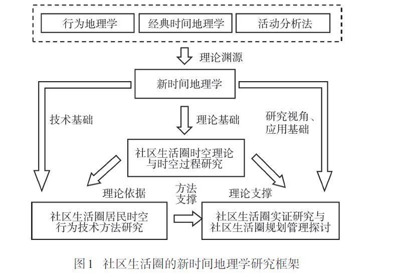
Community life circle examines urban communities from the perspective of residents' daily activities. It is the frontier of urban geography and urban related studies. It is also an important part of the innovation of Chinese territorial and spatial planning system and an important starting point for the sustainable development of China's urban society. With the continuous deepening of mobility and informatization, the agents of community life circles, community activities and residents' spatiotemporal behavior, and the function and meanings of community space are becoming more diversified, which needs innovative research and practical guidance of urban social geography. Time-geography is a comprehensive social-technical-ecological approach to understand the relationship between humans and the environment, which provides an essential basis for early research on community life circles based on activity space. New time-geography attaches great importance to the interactions and spatiotemporal combinations of projects between family and other social organizations. It can provide an important basis for the study of the complex interactions between individual, family, and community and the sociocultural constraints, the complex context analysis, and the simulation of spatiotemporal behavior in community life circles. Based on the new time-geography approach, this study proposed a new time-geography research framework of community life circle from theoretical, methodological, and empirical perspectives, including: 1) constructing the community life circle theory based on spatiotemporal behavior and revealing community life circle spatial and temporal structures; 2) developing methods for collecting and analyzing spatiotemporal behavioral data of community life circle and simulation; 3) innovating Chinese urban planning and management from the aspects of optimizing residents spatiotemporal behaviors within the community life circle, community social interaction life circle, and community safety life circle.
As the key of the Beijing-Tianjin-Hebei coordinated development strategy, non-capital function transfer is of great significance for solving the problem of a congested Beijing and achieving the sustainable development of the Beijing-Tianjin-Hebei region. This study constructed an analytical framework of change of industrial investment networks, which include the intrinsic attributes of industries, resource endowments, market mechanisms, and governmental response mechanisms. Taking the central core area of the Beijing-Tianjin-Hebei region as a sample, the study used the big data of industrial and commercial enterprise investment to measure the capital flow characteristics of the three key industries with non-capital functions in 2010, 2014, and 2018, and analyzed the process of change of industrial investment networks from the three levels of node-path-pattern under the background of functional dispersal. The research results show that the spillover trend of various industries' investment in Beijing has increased, and industrial agglomerations of non-capital functions are gradually shifting to the periphery of the central city under the background of non-capital function dispersal, but the pattern of change of different industries varies. The manufacturing industry presents a path of change from neighborhood diffusion to hierarchical diffusion, and is developing towards a multi-center pattern; the wholesale and retail industry shows the characteristics of spillover at the level of net capital flow, and agglomeration at the level of backbone path, which evolves from the single centric pattern around Beijing to the dual core linkages between Beijing and Tianjin; the transportation, warehousing, and logistics industries are clustered around the locations of suburban logistics parks outside the city, but the overall development of the network is lagging. The results of this study can provide a reference for understanding of the capital's functional transfer and the dynamic change of industrial structure and industrial development of the central core area of the Beijing-Tianjin-Hebei region.
The transition of cultivated land use represents the change trend of cultivated land use form. Taking 157 counties in the Beijing-Tianjin-Hebei region as cases, this study constructed the index system of cultivated land use form from the dual attributes of dominant form and recessive form. The spatial and temporal characteristics of change of cultivated land use form were analyzed by the methods of cold/hot spot analysis and spatial variation functions. On this basis, the driving mechanism of cultivated land use transition is quantitatively analyzed by the spatial error model (SEM). The results show that: 1) Cultivated land use form index values in the Beijing-Tianjin-Hebei region is high in the southeast and low in the northwest, which is consistent with the terrain distribution pattern in the region. Due to the development of characteristic agriculture on the Bashang Plateau, an independent high-value area was formed. 2) The spatial differentiation of cultivated land use form index in the Beijing-Tianjin-Hebei region shows a trend of gradual reduction. The distribution of significant hot spots and significant cold spots is relatively stable and the area continues to shrink, which indicates that the transition of cultivated land use is relatively steady. Specifically, the dominant morphological value generally increases first and then decreases, while the recessive morphological value increases, demonstrating that the cultivated land in the Beijing-Tianjin-Hebei region is undergoing spatial contraction and functional optimization transitions. 3) Elevation is the main natural environmental factor that affects the spatial characteristics of cultivated land utilization, while the economic and urban development factors such as the proportion of secondary and tertiary industries, average fixed asset investment, and urbanization rate are the leading factors driving the transition of cultivated land in the Beijing-Tianjin-Hebei region from 1990 to 2015. However, there are differences in the dynamic mechanism of cultivated land use transition in different time periods and different county units, and the intensity of each driving factor is also different.
Taking Haohuahong Village, a rural tourist resort in Huishui County of Guizhou Province, as a typical case and using spatial analysis method and high-resolution remote sensing and field survey data, this study analyzed the pattern of change of land use functions of the village in the past 14 years, and probed into the role of land use function transformation in boosting rural revitalization. The results show that: 1) Land use functions of the village are affected by land use transition and was transformed from the traditional single function of agricultural production, social security, and ecological conservation into a compound leisure sightseeing and economic development function, increasing the economic benefit while ensuring the ecological benefits, and showing the characteristics of diversity and integration. 2) There are significant differences in the pattern of change in the different stages of development in the research area, including the stage of single agricultural production function, the stage of multiple function transformation transition, and the stage of multi-functional compound transformation. The change of land use functions includes three modes: mainly agriculture but supplemented by rural tourism, combining agriculture and tourism; gradually shrinking agriculture, and mainly rural tourism; and overall transformation. 3) Natural conditions are the basis of the land use functional change; changing operators is the inner impetus for the transformation of land use functions; regional development policy is the fundamental driving force; and the demand of expanding the scale of the tourism market is also an important driving factor of rural and land use functional change. These factors interact with each other, and together drive the change of land use functions.
Community-oriented new retail is a new business model and important area of interaction between business and community, and worth further examination from the view of urban space. Based on the data of Freshippo stores in Nanjing, related points of interest (POIs) and areas of interest (AOIs), we use statistical analysis, spatial analysis, and field investigation to explore the service types and objects, spatial patterns, and location factors of Freshippo stores, in order to provide some recommendations for the optimization of business development. The results indicate that: 1) The service objects of Freshippo stores in Nanjing are mainly communities, supplemented by hotels and office buildings. The most of customers are young and middle-aged people with certain economic status and consumption ability. 2) There are five Freshippo stores in the urban areas and seven Freshippo stores in the near suburban areas, which form three clusters in the north-south direction. All stores have a point location with irregular service areas, which forms a core-periphery structure. The actual scope of delivery is different from the 3km buffer area. 3) The location choice of Freshippo stores is mainly affected by the density of communities and transportation conditions, and also dependent on land price and business zones, while competitors have a slight impact on the choice of the store locations. The stores are mainly located in medium and high-density areas of communities, marginal areas of business districts, both sides of the main roads, and the medium land value areas. Online delivery service is used to expand the scope of services to acquire more potential target customers. Finally, we explore the influencing mechanism of location choice from three aspects of consumer groups, operating costs and brand competition, and put forward some recommendations for the optimization of development in the future.
As the most important parts of urban systems, jobs and housing spaces and their balance directly affect the spatial structure of cities, the behavior and experience of the residents, and the harmony and livability of the society. This study used more than 100 million records of mobile phone signaling data, covering the whole city of Beijing and over a period of one month, to identify the jobs-housing spaces by targeting the origin-destination (OD) oriented connections applying the density-based spatial clustering of applications with noise (DBSCAN) method. Furthermore, this study explored the spatial distribution pattern and matching characteristics of Beijing's jobs and housing spaces from different spatial scales by using various measurement methods of jobs-housing balance. The spatial scales for analysis cover the whole city, ring roads, districts, and residential community and town and townships, and the methods applied include the spatial mismatch index, deviation degree, commuting flow rate, and so on. The results show that: 1) Mainly influenced by the spatial layout of the Beijing Master Plan, Beijing's housing space is characterized by dispersion at the large scale and agglomeration at the small scale, showing a pattern of scattered groupings. In contrast, its working space presents features of agglomeration at the large scale and dispersion at the small scale, retaining a significant single-centered layout. 2) Although working in local areas is the first choice for people at both the ring road scale and the district scale, there are still a great number of people works outside their residential areas. The degree of jobs-housing mismatch gradually decreases from the central city to the periphery no matter which method was adopted or at which scale. At the residential community and town and township scale, however, a more detailed feature of three-zones, with job agglomeration inside, housing agglomeration in between, and balanced distribution outside, was observed. 3) Both the general lack of jobs in certain areas caused by the high concentration of working space and the two-way commuting phenomenon in the majority of the areas caused by the high spatial concentration of jobs indicate the necessity of spatial reorganization of residential function and employment function. Specifically, for the regions with a high proportion of two-way commuting flow between them, such as Chaoyang-Changping, Tongzhou-Daxing, Haidian-Changping, Mentougou-Shijingshan, and Chaoyang-Tongzhou, further in-depth investigation should be conducted to find out the reasons for its formation and then possible industrial adjustment or functional reconstruction from the city level should be coordinated. Relying on big data, on the one hand, the job preference and demand of local residents can be identified, so the types and number of jobs in each region could be adjusted accordingly; on the other hand, the proper locations for new job and residential centers may be identified to help rearrange the land use of the whole city.
Commuting is an issue that urban residents must face in their day-to-day work. The health problems caused by long-distance, long-time, and motorized commuting have aroused widespread concern of scholars in China and internationally. Based on the survey data of physical activity and health status of residents in eight typical communities in Nanjing City from 2017 to 2018, a structural equation model was constructed to analyze the relationship between commuting distance, commuting time, and commuting mode and their impacts on mental health, physical health, and health behavior. The research findings show that: 1) Commuting distance has a significantly positive direct effect on commuting mode and commuting time, while commuting distance has a significantly positive indirect effect on commuting time. 2) In terms of the impact on mental health, commuting distance, commuting time, and commuting mode have a significantly negative direct effect on the neighborhood relationship. At the same time, there is also a significantly negative indirect effect of commuting distance and commuting mode on the neighborhood relationship. In terms of the impact on physical health, commuting distance reduces the probability of overweight or obesity among urban residents, but increases the probability of workers choosing a motorized commuting mode, which indirectly increases the risk of chronic diseases for the commuters. In terms of the impact on health behavior, commuting distance and commuting time are significantly negative correlated with sleeping time. Commuting mode has a negative indirect impact on sleeping time. Motor vehicle commuting mode is also significantly negative correlated with housework and significantly positive correlated with walking behavior. 3) The impacts of commuting behavior characteristics on health vary depending on the socioeconomic attributes of the commuters. The commuting behavior characteristics of female, older, and lower-income workers have a more significant impact on health. Based on the results of this study, we recommend to optimize the working and living space in the city, reduce commuting time, reduce car dependence, promote active commuting to increase the physical activity of commuters, and create more favorable conditions for the commuting of special groups, thereby improve their health.
The form of population migration and mobility constitutes a key element of the characteristics of migration. Since China has entered the late-intermediate stage of urbanization, it is very important to accurately identify and understand the transformation in the form of population migration and mobility. While a growing body of literature has been generated and significant progress has been made on China's population migration and mobility and its determinants, an important inadequacy of relevant research are often focused on rural to urban population migration and mobility, neglecting the multi-dimensional forms of population migration and mobility. Based on relevant theories and international experience relating to the transformation in the forms of population migration and mobility, and using data from the China Migrants Dynamic Survey (CMDS), Report on Monitoring and Investigation of Migrant Workers in China, and relevant statistics, this study examined the processes of the transformation in the forms of the population migration and mobility in China and their characteristics at the present stage and the issues and challenges arising therefrom. The results show that there have been significant changes in the forms of population migration and mobility in China, and such changes mainly manifest in the following aspects: First, there has been a steady increase in return migration and short-distance migration; Second, inter-urban migration has also significantly increased and become increasingly common; Third, the urbanization process of the floating population based on the rural-urban transfer of their hukou has started to accelerate, and their rural-urban multiple livelihoods has increasingly shifted towards the urban end; Fourth, there has been a developing trend of urbanization driven by housing purchases in both migrants' places of origin and destination. The study also identified issues and challenges in the process of transformation in the forms of population migration and mobility, including: First, there is a lack of sustainability in in situ urbanization promoted by return migration; Second, urban-urban migration are highly concentrated in a few provinces of the eastern region; Third, there are still many obstacles for the urbanization of rural migrants based on their hukou transfer. Finally, the article puts forward some policy recommendations from the perspectives of the construction of multi-level spatial system of urbanization of the floating population, the transformation of urban governance mode, and the promotion of the capacity for sustainable development of small towns in central and western regions.
Population distribution is an important indicator of regional development patterns. Also, regional coordinated development is closely related to the balanced distribution of the population. In the context of the regional integration of the Yangtze River Delta as a national strategy, the population distribution across the Yangtze River Delta has undergone significant changes. Using Kernal density analysis, gravity center analysis, concentration index, and shift-share analysis methods, this study examined the spatio-temporal change characteristics of the population in the Yangtze River Delta from 2000 to 2018, and explored the influencing factors as well as internal mechanisms of population growth shifts by utilizing quantitative methods. The main conclusions are as follows: 1) The shift in the population distribution trend led by some cities did not significantly change the imbalanced pattern of regional population distribution, and the increase in the concentration index indicates that the regional population concentration showed a steady growth trend. 2) The research based on shift-share analysis found that the shift in population growth pattern was mainly manifested in the acceleration of population growth in some underdeveloped areas. For example, Anhui Province was transformed into positive growth shift at the provincial scale. On the city scale, the positive growth shift dominated by core developed cities has changed to the positive growth shift dominated by some less developed cities. The spatial distribution of positive growth shift of municipal districts changed from the core areas to the peripheral areas. However, the population was still attracted to a few large cities and municipal districts. The diversified population growth shift trend characterizes the differentiated demands for future development strategies. 3) Economic factors, social development, and financial resources were important driving forces of population growth shift in the Yangtze River Delta. However, the temporal and spatial change of influencing factors shows that the formulation of future population balancing policies not only needs to be adapted to local conditions, but also should evolve through time. This research not only provides a reference for the formulation of relevant population policies, but also enriches the empirical findings on the spatial and temporal change of population.
Returning to the area of origin has become an important trend of migrant worker decision in China, and it will reshape the spatial pattern of rural population mobility in the future. Based on the data from field survey of 901 returnee migrant workers, descriptive statistics and multiple logistic regression methods were used to examine the work location choice of the returnee migrant workers and influencing factors. The results show that after the return of migrant workers, the choice of work location is mainly in county seats, followed by villages, and fewer returnees chose central urban areas and towns. Inter- and intra-provincial flows are the basic forms of return for migrant workers, but there are some differences between these two groups of returnees. The work locations of returnees are mainly in the local areas of their origin, but there are also a few who chose non-local locations. The significant factors influencing the choice of the work location for returnees mainly include age, residential location, village per capita income, village employment ratio, village topography, former work place types, and return source areas. After the return of migrant workers, although the problem of long-distance travel across regions has been solved, the issue of balancing between work and family care still exists at a smaller spatial scale. Distance plays an important role in the return location choice of migrant workers. The location of residence is often also the location of work. The exchange of information within the community affects the returnees' evaluation on the benefits of work. It has become an important mechanism for the decision of the migrant workers. Path dependence is a common phenomenon in the choice of work location for the returnee migrant workers. County seats should become the focus and main carrier of the new urbanization development in the rural areas.
The change of contemporary Chinese rural employment is an important perspective for understanding the change of rural human-land relationship. In this study, taking the rural households of Jingshan City on the Jianghan Plain as an example, we examined the characteristics of rural households' employment change in the research area through the change rate index and employment transfer matrix. This article described the changing characteristics of employment in three aspects: Employment type, employment space, and employment pattern. A multinomial Logistic regression model was used to analyze the influencing factors of rural households' employment pattern. The results show that: 1) From 2007 to 2017, the employment type of the surveyed rural households evolved from agricultural employment to part-time agricultural employment, with significant increase in non-agricultural employments. 2) Correspondingly, the distance attenuation characteristics of rural households' employment location choice weakened. The role of village as the starting point and returning sink of rural households' employment transfer is still prominent. 3) During the study period, pure agricultural employment in the rural area is still the main type of employment for the surveyed households, but the diversification of employments has become a new trend. 4) The choice of farmers' employment is the result of a combination of factors including farming households' employment demand, local employment opportunities, and environmental factors. Specifically, age of the head of the household, ratio of migrant workers, family dependency ratio, and family employment habits were taken as farming households' employment demand factors; the developing level of township and village development opportunities were taken as local employment opportunity factors; and distance from a village to town centers and regional employment satisfaction, and information and communication system development level were taken as environmental factors in the model. The results may shed some light on the change of human-land relationship and provide a theoretical support for the implementation of the rural revitalization strategy in typical agricultural regions of China.
Reconciling the conflicts between the protection and use of tourism resources is one of the key issues to be solved urgently in the development of protected areas. Based on a review of the characteristics and models of development and use of tourism resources in protected areas in China and using qualitative research methods, this study analyzed the conflicts of tourism resource use in protected areas in China, and explored the formation mechanism of tourism resource use conflicts in protected areas. From the perspectives of ecological protection, community development, and related theories, we discussed the feasibility and assessed the situation of tourism resource use in protected areas at the current stage. Finally, to establish an integrated resource use system with clear rights and responsibilities for stakeholders in protected areas, strengthen the research on the assessment of the environmental effects of tourism resource use activities, explore the dynamic models of protection and use of natural ecological resources based on local conditions, establish a more precise resource use zoning plan for the protection of protected areas, and take the ecological concept as guidance to creatively develop new types of ecotourism products, we proposed a reasonable path for tourism resource use in protected areas. The conclusions of the article may help the society to understand the conflicts in the use of tourism resources in protected areas from a systematic perspective, and may be used as a reference for promoting the balanced use of natural ecological resources.
This article summarizes the geographical research on immigration and in particular the research on the floating population of China in the context of globalization and new-type urbanization, and discusses the research progress and trends of immigration geography from the perspective of "cultural turn". The findings include: 1) The geographic studies of migration mainly focuses on the mode of immigration and research of motivation, the local negotiation research of immigrants, the cultural interaction of immigrants and the daily life, and identity and emotion of immigrants; and the geographies of migration focus on the human-land relationships of "immigrant-place", especially the practice and negotiation of place. 2) Under the influence of "cultural turn", the geographic research of migration has gradually switched the focus from the macro structures of migration to the micro contexts of everyday life, emotion, power, and social relations, which increasingly engages in the diversity and complexity of migration. 3) The research on Chinese migration mainly focuses on the floating population in the context of "urban-rural" dualism, which needs to be extended to research on the diverse immigrants in the context of globalization. This article attempts to expand the research agenda about the geographies of migration in China and produce the new knowledge of immigration based on the discourse of developing countries.
Rural amenity is a key concept in rural studies in western developed countries. However, it has drawn little attention from Chinese scholars, and very little work has been done to date in China's context. One plausible reason is that the longstanding urban-rural divide has left rural regions in China far behind the urban areas and thus lacks the quality to be considered amiable. However, with the recent development, especially under the current nationwide campaign on rural revitalization, rural areas in China has witnessed a rapid improvement of facilities and infrastructure, which has laid the foundation for examining rural amenity with Chinese characteristics. This study aimed to introduce the concept of rural amenity to the academia in China. Through a systematic literature review of existing studies on rural amenity published in international journals, the study aimed to stimulate discussions and debates on the concept from Chinese scholars. This article reviews and summarizes the definition, connotation, and characteristics of the concept adopted by international scholars. It then focuses on four major research areas on rural amenity: Rural amenity index and its impacts, rural amenity and counter-urbanization, rural amenity and rural development, and amenity migration. This article further discusses several issues related to the theoretical aspects of the concept, including comparison of urban amenity and rural amenity, comparison of rural amenity and rural gentrification, and translation of rural amenity/amenities into Chinese. Finally, this article concludes with four insights that can be drawn from understanding rural amenity in China: First, defining rural amenity in China based on traditional Chinese culture. Second, building rural attractiveness and competitiveness based on quality of place. Third, improving rural ecosystem and built environment based on the needs of a variety of dwellers. Fourth, exploring ways of co-development of rural amenity and rural industries with a focus on synergy. This article emphasizes that with continuous deepening of rural revitalization and improvement of rural ecological environment and infrastructure in China, it is of great theoretical and practical value to conduct comprehensive and in-depth research on rural amenity within the Chinese context.
