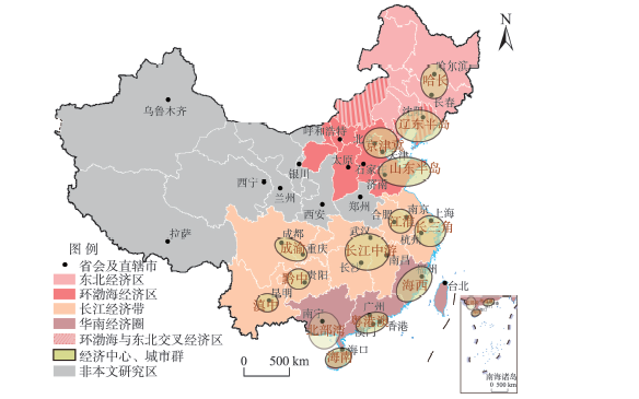
On the basis of the Third National Report on Climate Change of China and using the latest scientific literature on climate change of China since 2012 and China climate bulletins, this study assessed the climate changes of four national-level economic zones of China—the Bohai Economic Rim (BER), the Yangtze River Economic Belt (YREB), the South China Economic Zone (SCEZ), and the Northeast China Economic Zone (NEEZ)—during recent decades. The main conclusions are: 1) Annual temperature increased at a rate of 0.35 ℃/10 a, 0.20 ℃/10 a, 0.20 ℃/10 a, and 0.33 ℃/10 a for the BER, YREB, SCEZ, and NEEZ, respectively, over the period 1961 to 2018. Although there was a climate warming slowdown in these regions during 1998-2014, the annual temperature after 2014 broke the warmest records for the BER, YREB, and SCEZ. 2) Precipitation changes over the period 1961 to 2018 were lower than 1 mm/10 a for each region, but there were significant inter-annual and inter-decadal oscillations. Precipitation during 2012-2018 were mostly more than normal, but with large spatiotemporal variability. The precipitation of NEEZ in 2013 and precipitation of YREB in 2016 respectively reached the highest values since 1961, but precipitation of Liaoning Province in 2014 reached the lowest since 1961. 3) During 2014-2018, there were more frequent extreme heat events in each region, whose maximum temperature broke historical heat extremes or exceeded the extreme high temperature threshold, that is, the 9th decile. Meanwhile, there were increases in the frequency of inter-seasonal droughts and extreme rainstorms in the BER and NEEZ; and there were more rainstorm days in the YREB and more severe impacts of typhoons in the SCEZ. There were also extensive extreme low temperature events in the context of climate warming in the YREB and NEEZ.
Network structural resilience is an important direction for the future development of urban spatial organization, which is of great significance for the high-quality coordinated development of urban agglomerations. On the basis of systematic review and summary of existing theoretical and empirical research on complex networks, we built a model to evaluate the evolution characteristics of urban network structural resilience. Taking the Harbin-Dalian urban belt as the research object, we explored the evolution direction and quality of multiple urban network structural resilience. The results show that: 1) There are differences in the hierarchy and matching of multiple urban networks. In terms of hierarchy, transportation and financial networks tend to be flat, while information and innovation networks tend to be three dimensional; In terms of matching, transportation network and innovation network are characterized by homogeneity and heterogeneity respectively, and their characteristics are strengthened, while financial network and information network are characterized by heterogeneity but their characteristics are weakened. 2) Network structural resilience type remains stable. Transportation network can be characterized as core-periphery network of homogeneity, while finance, information, and innovation networks can be categorized as resilient network. The structural resilience of transportation and financial networks has declined, while that of information and innovation networks has increased. The comprehensive level of resilience evolution is as follows: innovation cooperation network > information association network > 0 > financial connection network > transportation network. 3) The restrictive factors of the resilience evolution of urban network structure in the Harbin-Dalian urban belt can be traced back to three aspects: core cities, peripheral cities, and factor flow. In view of these, we put forward the optimization path of the resilience evolution of urban network structure in the Harbin-Dalian urban belt from three aspects: overall structure, regional difference, and factor flow.
In recent years, rural geographers have made in-depth research on the utilization of resources, environmental change, economic development, spatial system, and regional pattern of rural areas. However, the research on the subjects/actors of rural development is relatively weak. Most of these studies focus on the temporal and spatial changes of population and interregional migration. In contrast, insufficient attention is paid to the subgroups of rural development subjects/actors. Rural elite is one of the main subjects of rural governance in China and an important force to promote the modernization of rural governance. Rural elite can often stimulate endogenous motivations, integrate external resources, and organize people to carry out a series of actions based on policy guidance and village resources to promote rural transformation and development. In-depth research on the roles, activities, and problems of rural elite in rural governance has important practical significance. This article analyzed the related concepts of rural elite and explored the active role of rural elite in maintaining the stability of rural society, promoting the economic development of villages, driving entrepreneurship, and fulfilling social responsibilities. We also analyzed the negative effects of autocracy and "distributed order" caused by the concentration of power, and discussed the obstacles and deficiencies of rural governance by rural elite. Rural elite refers to the individuals who are recognized by most villagers in a specific rural area, have strong motivation of development, personal ability, and social network, and are willing to lead or have driven rural development through own expertise. Generally, rural elite is the "engine" for promoting progress, the "locomotive" for collective action, the pioneer for village development, the "bridge builder" for external contact, and the leader of rural vitalization. However, if the supervision mechanism is absent, rural elite may also bring negative effects on the democracy, economic development, and law and order of local areas. In order to better realize the modernization of the rural governance system and governance capacity in China, it is recommended to further strengthen case studies of rural elite governance, deepen the theoretical research of rural elite governance, and explore innovative models for training rural elites. Specifically, it is necessary to strengthen the research on the emerging mechanism and cultivation model of rural elites, deepen the research on the mechanism, mode, and effect of governance by rural elites, pay attention to the new situation and problems of governance by rural elites, and explore the data and methods for the research on rural elites. Strengthening the research of rural elite is helpful for enriching the content and theory of rural geography.
Resource-based cities are widely distributed in the Yellow River Basin and face prominent problems. Improving urban efficiency and promoting the transformation of resource-based cities are an important way to achieve ecological protection and high-quality development in the Yellow River Basin. This study used the data envelopment analysis (DEA) model to evaluate the transformation efficiency of 41 resource-based cities in the Yellow River Basin from 2007 to 2017. It further carried out a panel regression analysis on the factors that influence the transformation efficiency of resource-based cities through the fixed effect model. The results show that: 1) Transformation efficiency of resource-based cities in the Yellow River Basin is not ideal. The number of cities with the best comprehensive efficiency reached 39.02% of all cities in 2017, but the gap in transformation efficiency has widened since 2015. 2) Scale efficiency is the main determining factor of comprehensive efficiency. The number of cities with the best scale efficiency increased first and then decreased, and the feature of decreasing returns to scale became increasingly more obvious, which indicates that there was a input redundancy in the transformation efficiency of some cities. 3) On the whole, per capita GDP, the proportion of government financial revenue in GDP, and the number of students in ordinary higher education institutions have a significant positive effect on the transformation efficiency of resource-based cities, while the proportion of the tertiary industry has a significant negative effect. With regard to different types of resource-based cities, the proportion of foreign-invested industrial enterprises has a significant positive effect on the transformation efficiency of coal-based cities, and the proportion of mining employees has a significant positive effect on the transformation efficiency of mature resource-based cities. The factors influencing the transformation efficiency of different cities are different.
Urban agglomeration is an important engine for the development of economic and social systems in a country or region, and its development cannot be separated from the use of construction land. However, there is a time-lag effect of urban agglomeration construction land growth on economic growth due to the process of land investment, construction land development, benefit generation, benefit enhancement, and benefit stabilization. Therefore, it is of great significance for the supply and management of regional construction land and the sustainable development of the economy and the society to calculate the length of lag period and the size of total effect, and to explore its internal mechanism. Based on the statistical data of 13 major cities in the Beijing-Tianjin-Hebei urban agglomeration from 1995 to 2017, this study put forward a lag variable model of the construction land growth to economic growth, and obtained the number of lag period, the effect of each period, and the total effect of each city in the region. This study also analyzed the reasons for the differences in time-effect combined with the level, functional orientation, and industrial composition of each city. The research found that: 1) There is a general lag effect of construction land growth on economic growth in the urban agglomeration, with a lag period of 0-4 years. 2) The growth of the urban agglomeration's construction land has a significant positive effect on economic growth, and the total effect is between 1.66 billion-49.5 billion yuan/km2. 3) The lag period and total effect of urban agglomeration construction land growth on economic growth show the spatial differentiation feature of core-periphery differences. 4) The lag period is mainly related to the level and function of the cities. The lag periods of high-level central city, medium level sub-central city, and low-level node city are 4 years, 2 years, and 0-2 years respectively. 5) The total effect is mainly related to the industrial composition. The corresponding effects of high-end, medium-end, and low-end industries are 30 billion-50 billion yuan/km2, 10 billion-20 billion yuan/km2, and 1 billion-10 billion yuan/km2, respectively.
Unicorn company, a new term in today's business climate, is the integration of different types of innovations in the new era, and its internal relations and spatial organization reflect the pattern and characteristics of regional innovation networks. Consistent with the emerging entrepreneurship and the rapid development of the Internet, increasingly more unicorn companies appear in China, which provides an opportunity for us to catch a glimpse of China's innovation development through a new perspective. In this study, we used the ownership linkage model to map China's urban innovation network based on 164 Chinese unicorn companies' internal relations, and analyzed the spatial structure through the following social network analysis perspectives: urban hierarchy, association pattern, and city nodes. The "unicorn index" was developed as an indicator to evaluate the development and magnitude of a city's unicorn companies as well as its innovation environment and position in the network. Cities of high unicorn index values rank high in the urban innovation network hierarchy, which constitutes four tiers in a pyramid-shaped structure with 253 cities, only nine of which are in the top three tiers. Among them, Beijing, Shanghai, Hangzhou, and Shenzhen show their innovative activity and advanced development in the unicorn entrepreneurship. To analyze the association pattern, we calculated the network density, assortativity coefficient, and the degree correlation for the network. The results show that most cities are not closely linked with each other in this generally loose-association urban innovation network, while intensive connections only happen between the cities with high unicorn index, highlighting an intensive-connection diamond-shaped structure. To further examine each city node, we regard outdegree as its innovative influence and "power", indegree as its innovative attraction and "prestige", and eigenvector centrality as its connectivity. We found that Beijing and Shanghai still play leading roles in the innovation network, but Nanjing and Wuhan start to exhibit innovative attraction and potential. In conclusion, the development of urban innovation network is driven by four leading cities—Beijing, Shanghai, Hangzhou, and Shenzhen, showing a spatial polarization character. The network pattern highlights a diamond structure whose activity weakens from the east to the west. Cities having high unicorn index are strongly linked to each other and playing important roles while other cities enter the network by establishing links to those cities, shaping the core-periphery network structure. Moreover, those important cities enjoy power and prestige and have various influences in the innovation network. This study provides a new look into China's urban innovation network and some insights for policymakers to promote urban innovation. Also, the unicorn index can be considered in city innovation evaluation.
To investigate the current status of the distribution of selenium (Se) in the environment, food, and human body in the Kashin-Beck Disease (KBD) endemic areas of the Qinghai-Tibet Plateau, literature on Se contents in soil, food, drinking water, and human hair in the Qinghai-Tibet Plateau KBD endemic areas published during 2000-2018 were searched and collected from databases including the China National Knowledge Infrastructure (CNKI), Web of Science (WoS), and Google Scholar. Based on a series of selection criteria, 33 of the retrieved articles were identified and valid data were extracted for statistical analysis. The results show that the natural environment in the Qinghai-Tibet Plateau KBD endemic areas was still in low-Se cycle status. Average Se contents in cultivated soil and drinking water were 0.147 mg·kg-1 and 0.54 μg·L-1; average Se contents in local-produced highland barley, wheat, and tsamba and imported rice were 9.27, 19.08, 11.07, and 43.29 μg·kg-1, respectively. Compared with the years before 1990, a clear increasing trend was observed in Se nutrition level of children in the KBD endemic areas. The average Se content in children's hair was 0.234 mg·kg-1, which is basically above the low-Se range (< 0.20 mg·kg-1). No significant correlation was observed between total soil Se and Se in children's hair (r=0.125, P>0.05, N=23). The inconsistent changing trend of Se levels between children's hair and the natural environment in the Qinghai-Tibet Plateau KBD areas suggests that social and human interventions increased the input of exogenous Se, which weakened the dependence of local residents on the low-Se environment to some extent. This might be the main reason that the prevalence of KBD in the Qinghai-Tibet Plateau declined steadily and was brought under effective control.
National key towns are the leader in the development of small towns. The formation of scientific and reasonable national key town layouts is of great significance for optimizing China's urbanization strategy. Taking the 1887 and 3675 national key towns published in 2004 and 2014 respectively as samples, this study used geodector and the geographically weighted regression (GWR) model to explore the changing characteristics of their distribution and analyze the influencing factors of national key town layouts and effects at the prefecture level. The results show that: 1) After the adjustment by the government, the balance of the layout and construction effect of national key towns is enhanced. The main gathering areas moved westward and northward, the distribution of cold spots and hotspots break through the "Hu Huanyong Line", and the degree of differentiation of economic radiation effect is weakened, reflecting the powerful influence of policy factors. In addition to the inter-county balance and regional preferential policies, the distribution of national key towns is also significantly affected by factors such as altitude, road network density, and resident population urbanization rate. 2) The combination of the factor detector, the GWR model, and the interaction detector can more accurately characterize the mode of action, direction, path, and intensity of the influencing factors. The layout of national key towns is not the result of the uniform, independent, and direct effect of the five significant factors, but the product of the synergistic effect of the interaction of the factors with spatial heterogeneity. 3) The synergy between the inter-county balance policy and other factors is the dominant force in the formation of the existing layout of the key towns; the effect of the regional preferential policy is overall positive, but the target areas need to be more accurately identified.
In recent years, homestay inn has developed and matured based on its personalized services and cozy accommodation experience. Its spatial agglomeration also promotes the homestay inn industry to grow in clusters and become specialized. This study chose Hangzhou City in Zhejiang Province, Huzhou City in Zhejiang Province, and Enshi City in Hubei Province, which are the typical areas of the homestay inn industry, as cases. Based on the homestay inn data of Tujia.com, this study used global spatial association indicators and Getis-Ord Gi * index to explore the agglomeration pattern and influencing factors of the three areas. The spatial distributions of homestay inn in Hangzhou, Huzhou, and Enshi Cities all show an agglomeration pattern, and the largest hot spot region of Hangzhou spreads around the city center. The spatial agglomeration pattern of homestay inn of Hangzhou is based on locations within the city. The hot spot region of homestay inn in Huzhou is far away from the city center and spreads around the Mogan Mountains. The spatial agglomeration pattern of homestay inn of Huzhou is based on the regional brand. The hot spot region of Enshi homestay inn consists of three small hot spots, which are all connected to the scenic spots. The spatial agglomeration pattern of homestay inn of Enshi is based on the scenic spots. Through the analysis of location, transportation, tourism resources, and regional brands of the three areas, the study showed that location is the basis of the agglomeration of homestay inn in cities. Regional brand is a booster to promote the agglomeration of homestay inn. Tourism resources are the early motivation of clustering for homestay inn. Road transportation is a guarantee for the clustering and expansion of the homestay inn. The conclusions provide a useful reference for choosing reasonable locations for homestay inn and allocating resources rationally.
Development and evolution of large rivers is a classic subject of geomorphology. As one of the seven large rivers in China, the Huaihe River locates in China's north-south transitional zone. However, there is much controversy about its formation and development. In this study, we explored and discussed the formation of different sections of the Huaihe River based on the analysis of topography and sedimentary stratigraphy. The results show that there were two major adjustments of the river system in the Huaihe River Basin during the Cenozoic period, which occurred at the end of the Paleogene and the end of the Pliocene, respectively. During the Paleogene and Neogene periods, lacustrine sediments were extensively developed in the Huaihe River Basin, with the sedimentary environment dominated by rivers and lakes. However, during the Quaternary period, the sedimentary environment in the basin gradually changed to a river-dominated system. The formation of the modern river-lake system in the Huaihe River Basin occurred in the early- to mid-Pleistocene. Tectonic activities and climate change were the main drivers of the evolution of the Huaihe River system. The Qingzang Movement from the late Pliocene to the early Pleistocene led to the disintegration of the Neogene hydrological system in the Huaihe River Basin. In addition, the cooling climate in the Late Cenozoic may be the cause of decreasing lake developments and increasing river activites.
Under the background of global environmental change and urbanization, various risks and uncertainties have posed an important obstacle on urban security and urban sustainable development. As a potential new approach of urban risk management, urban resilience can improve the ability to resist, dissolve, and adapt when facing risks and uncertainties, and expound the adaptive scheme of risks in the process of rapid urbanization. Urban resilience has been a new topic in geography and related disciplines. Based on the origin and concept of urban resilience research, from the perspective of the impact of various factors (human, environmental, disaster) on urban resilience, this study constructed a theoretical framework of urban resilience, including evaluation and scenario simulation, and discussed the status of urban resilience research, pointing out that there are still many weak links in the theoretical framework, mechanism, practical application, and difference analysis of urban resilience research. Finally, the key directions of urban resilience research were also discussed. The theoretical framework should be used as a guide to promote multi-objective, multi-level, and multi-perspective systematic evaluation research. With the analysis of mechanism as support, studies should aim to achieve a new breakthrough in process simulation of urban resilience and decision making and early warning. Oriented by empirical research, studies should continue to strengthen the application model of multidisciplinary integration and exploration of urban resilience. Considering regional differences, further work should try to achieve a change in urban planning from the unified "one policy for multi-city" approach to the flexible "one policy for one city" approach.
It is expected that the world economy would be gradually integrated and interconnected by trade liberalization and progress in technology in globalization era. However, researchers have found that international trade remains significantly affected by geographies. At the same time, economic geographers put little effort on building theories about geographies of international trade and their main contribution in this field is confined to descriptive analysis on the heterogeneous patterns and network structures of international trade. In this article, how geographies affect trade in international economic studies is reviewed from three dimensions—production, circulation, and consumption. Differences on production side promote trade through the intermediation of opportunity cost while differences in circulation process hinder trade by increasing trade cost. Differences on consumption side affect trade through the intermediation of demand level. By summarizing the literature on the relationship between trade and institutional change, trade and urban agglomeration, trade and inequality, trade and innovation, and trade and pollution, we identify three major limitations of these studies. First, few studies dig into the endogeneity of geography systematically. Spatial disparity can be shaped by international trade rather than only determining international trade. Second, there is a dearth of multi-scale and inter-scale perspective despite that gains from trade at the macro level predicted by traditional trade theory are found not evenly distributed at the meso and micro levels, resulting in evident spatial disparity. Third, some of the studies do not fully explore product heterogeneity, thus cannot completely capture the various spatial impacts of trade. Therefore, possible contribution of economic geographers to international trade studies lies in thorough investigation on multi-dimensional heterogeneity and complex interactions between geographies and international trade from multi-scale and inter-scale perspective.
Soil erosion is one of the most serious environmental problems in China. Soil erosion model is an efficient tool for diagnosing and preventing soil erosion. Stochastic simulation of precipitation can generate synthetic input data for soil erosion models when observation data are absent. This study summarized the main progress of rainfall process stochastic simulation in existing studies. One-minute resolution rainfall data were collected from 18 weather stations distributed in the main water erosion areas to analyze the characteristics of the storm process and calibrate, evaluate, and develop CLImate GENerator (CLIGEN) stochastic models for China. The main results are as follows: 1) Minimum inter-event time (MIT) for separating precipitation events from continuous precipitation recording ranged from 7.6 h to 16.6 h, with an average of 10.7 h. The MIT values calculated from 1-minute data and hourly data were not significantly different. Storm process characteristics such as the amount, duration, average intensity, and peak intensity of precipitation were sensitive to the variation of MIT values when the MIT values were smaller than 6 h, which suggests that the comparison of storm process characteristics for different storms and areas should use the same MIT value. 2) Events with peak intensity occurring in the first half of the duration of an event were dominant, which accounted for more than 65% of the total events and they were characterized by relatively short duration and greater intensity, comparing with events whose peak intensity fell in the second half of the duration of the events. 3) Weather generator CLIGEN in the Water Erosion Prediction Project (WEPP) soil erosion model can satisfactorily simulate the daily precipitation amounts (P), but it underestimated the storm duration (D) and overestimated the maximum 30-minute intensity (I30). The direction and degree of the bias for D and I30 were not consistent for different groups classified by different precipitation amounts. 4) A method was developed to use hourly precipitation data to prepare the TimePk and MX.5P parameters for CLIGEN input files for the generation of storm process data in the absence of high resolution hyetography precipitation data. More efforts are needed to improve the simulation of precipitation extremes and develop multi-site and multi-variable stochastic models conditioned on weather types in the future.
Soil moisture (SM) is a key variable for assessing agricultural drought. For a long time, due to the lack of large-scale, high-precision, continuous SM measurements, SM-based agricultural drought monitoring has been limited in application. With the recent development of remote sensing technologies, the spatial-temporal coverage and accuracy of SM data have been improved significantly. Agricultural drought monitoring indicators using SM have received increasing attention. This study systematically summarized the main characteristics of the SM data sets from multiple sources including in-situ measurements and microwave remote sensing, and further reviewed the three categories of agricultural drought indicators based on SM: 1) drought indicators based on long-term SM; 2) drought indicators based on both SM and soil hydraulic parameters; and 3) integrated drought indicators based on multiple variables including SM. Finally, with the aim of providing some reference for future research, we envisioned the challenges and opportunities for agricultural drought monitoring from the perspectives of 1) the development of SM data; 2) the strengthening of agricultural drought mechanism research; and 3) the improvement of agricultural drought monitoring systems.
Scientific and reasonable urban green space layout is an important guarantee of urban sustainable development. The research on the spatiotemporal change of urban green space pattern and its influencing factors could reveal its complex relationship with various factors and processes of urbanization to facilitate improvement of the function of ecosystem services of urban systems. In the context of ecological civilization construction, urban green space will play an important role in multi-scale territorial spatial planning, but how to combine them remains a challenge. Therefore, based on a review of the definition and development of urban green space patterns, we discussed the research progress of the spatiotemporal change, driving factors, scenario simulation, and optimization strategies of urban green space patterns. We also summarized the application of ecosystem services in urban green space evaluation. Finally, we explored the evaluation and optimization framework of urban green space patterns in the territorial spatial planning system, with a view of providing a reference for urban green space planning in the new era.