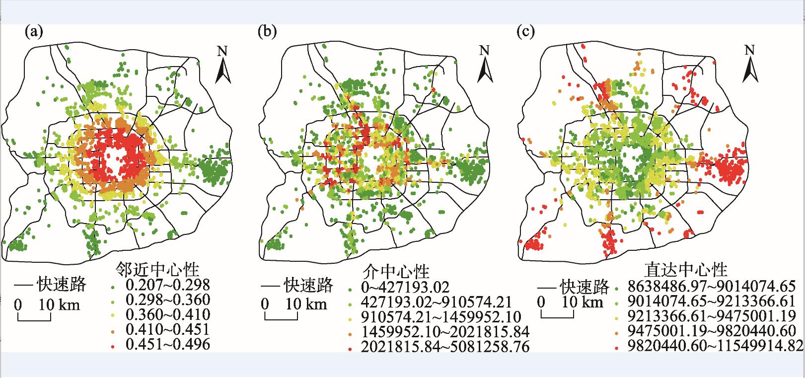
Higher housing demand leads to housing price increasing rapidly, with lower housing affordability. Under these circumstances, renting a place has progressively become an alternative way for residents of cities. Urban transportation is one of the most significant influencing factors for housing rent, which needs to be examined at greater depth. This study used complex network analysis to explore how transportation centrality impacts housing rent. The conclusions are: transportation network shows significant impacts on housing rent, with higher impacts of public transport network than street network. Closeness in public transport has the highest impact on housing rent. Each centrality aspect influences housing rent differently, and relative accessibility in public transport network and transfer capacity in street network have the greatest impacts on housing rent. This article discussed two modes of urban transportation and their spatial characteristics. By refining the impacts of different transportation modes by network analysis, it provides a new perspective of urban transportation research and its spatial effects.
City networks have experienced rapid reconstruction in the past decades due to the development of city-regions. In the Guangdong-Hong Kong-Macao Greater Bay Area, Guangzhou and Shenzhen are two pivotal cities. They play key roles in promoting regional development. Therefore, it is of great significance to identify their influence areas, which can inform urban management and regional planning. Meanwhile, increasing availability of social media data creates opportunities for relevant research. The pervasive presence of location-based services and the associated content make it possible for researchers to gain an unprecedented access to the direct records of human activities and perceptions. Much of existing literature, however, pays little attention to the differences in multi-scale network or to the relationship between the real-world network and virtual network, which are both presented in datasets of this kind. Our research contributes to the literature in both the methodological and the empirical aspects. First, we investigated the node and link characteristics of the influence areas of Guangzhou and Shenzhen by computing social network indicators with a dataset of almost 10 million Sina Microblog records between January 1 and February 6, 2018. Indices of mobility and attention were computed based on characteristics such as consecutive locations, degree centrality, closeness centrality, and average radius of gyration. These indices help to catch the interaction between real and virtual networks. Second, in order to understand inter-city mobility and attention characteristics of Guangzhou and Shenzhen, we mapped city networks of multi-scale, where edge weights denote interaction strengths. Third, our analysis confirmed that the Sina Microblog data exhibit similar statistical properties as other city network datasets. Based on the result of analyses, we argue that Guangzhou had more balanced influence in various directions, representing efficiency in hinterland connection and resource integration. Shenzhen's area of influence was relatively concentrated, with a strong tie with neighboring Hong Kong. Overall, Guangzhou competes better in the mobility network while Shenzhen competes better in the attention network. A complementary relationship was also identified between those two networks. In conclusion, we propose that Guangzhou and Shenzhen took advantage of their respective role as the hubs of regional transportation and innovation as well as what they have already accumulated and their connections with other parts of the world. They should help to build a coordinated and competitive Guangdong-Hong Kong-Macao Greater Bay Area. Our research results offer some insights for policymakers to interpret the geographic dynamics and make relevant decisions in this region. It also provides some references and inputs for analyzing social media data for the research community.
Making use of the advantages of different rural functions is an important way to realize rural revitalization. By constructing an index system of rural function evaluation and using GIS and the Theil index, the characteristics of production-living-ecological functions and source of regional differences in rural areas in the Yangtze River Economic Belt in 2016 were revealed. The results show that: 1) The spatial differentiation of production-living-ecological functions in rural areas of the Yangtze River Economic Belt was obvious. Midstream and downstream plain areas have a strong agricultural production function, downstream provincial capital cities and core development cities have powerful living function, and upstream and midstream mountainous and hilly areas have a strong ecological conservation function. 2) The overall regional differences in rural functions are derived from intraregional differences. The agricultural production function is significantly different within the upstream region, and the life and ecological conservation function is significantly different within the downstream region. The overall differences in rural functions in the midstream area are not significant. 3) Based on the evaluation results, the study area is divided into eight types of functional areas, namely, agricultural production area, living area, ecological conservation area, living-agricultural production area, living-ecological conservation area, agricultural production-ecological conservation area, agricultural production-living-ecological conservation development area, agricultural production-living-ecological conservation coordination area, thus providing a scientific basis for improving the spatial layout of rural functions in the Yangtze River Economic Belt.
In the context of rural revitalization and poverty alleviation through tourism proposed by the state, in order to give play to the driving role of tourism transportation in regional development, it is important to provide a theoretical basis for the construction of key villages for poverty alleviation through tourism and the acceleration of regional poverty alleviation. Taking 258 tourism poverty alleviation key villages of in the Wuling Mountain area of Hubei Province as research samples, this study used the raster cost-weighted distance algorithm and the geographically weighted regression (GWR) model to explore the spatial differences in the accessibility of tourism transportation and the influence degree and direction of the influencing factors. The results show that: In the Wuling Mountain area, the average time to reach the tourism poverty alleviation key villages is 1.82 hours, the overall regional accessibility is relatively poor, and the travel cost is high. Factors affecting the accessibility of tourism poverty alleviation key villages in both the natural and social dimensions were extracted. The order of the impact of each influencing factor in the region is as follows: shortest path from the nearest county and city > elevation > tourism resource endowment in the surrounding area > shortest distance from a river > shortest distance from the surrounding scenic spot > slope. The shortest distance from a river and surrounding tourism resource endowment are negatively correlated with the cost of access, while other factors are positively correlated with the cost of access. The unit change of the shortest distance from the surrounding scenic spot and the slope value has relatively insignificant influence on the spatial difference of access cost.
Existing criminal geography research has always focused on the number of cases, but neglected their severity. Limited by the availability of data, cross-sectional analysis was more universal than longitudinal, which would cause endogeneity problems. Furthermore, spatial dependence of different independent variables has not been systematically examined. In order to fill these gaps, this study utilized criminal case records, points of interest, and road network data from 2012 to 2017 in Beijing to explore spatial pattern of crime number and its harm, and clarify the role of urban built environment in their forming process. In order to measure the extent of crime harm, criminal penalty by judicial authorities was used as the indicator. First, this research demonstrated that both crime number and crime harm showed geographical concentration and agglomeration. However, concentration extent of crime harm was higher than crime number, but agglomeration extent of crime harm was lower than crime number. The degree of harmspot's stability was weaker than crimespot, therefore geographical analysis of crime number cannot fully reveal the spatial pattern of social harms caused by criminal cases. Second, permeable space postulated by street eyes theory was unable to inhibit criminal activities, while high density land use, diversified urban functions, convenient transport branch networks, and close spatial proximity to crime-prone areas could lead to the increase of crime number and crime harm, which is consistent with the prediction of defensible space theory. Additionally, crime harm was more susceptible to conducive built environment factors. Third, most influences caused by various characteristics of the built environment showed spatial dependence. Specifically, density, diversity, design of road network, as well as commercial place had agglomeration spillover effect, which meant that both local and neighboring environmental elements had positive relationship with native criminal activities. In contrast, local educational institutions, parks, squares, hotels, bus stops, parking lots, and residential areas that were strictly supervised had no effect or negative effect on native criminal activities, but neighboring attractors had significant positive impact on native criminal patterns. Because of this spatial competition effect, security measures should not confine to local areas and attractors.
Job-housing relationship is not only a reflection of urban residents' daily activities, but also an important criterion for assessing the quality of urban spatial layout. Since the economic reform of China in 1978, the original system of jobs and housing allocation has undergone considerable changes. Along with economic development and industrial upgrading, suburbanization process of manufacturing industry has taken place. Because of the reform of housing system and the suburbanization of industries in China, urban residents suffer from the impact of spatial mismatch between residence and work. Newly-employed college graduates, migrant workers, and low- and middle-income people often face the problem of unequal housing opportunities as well as unique problems in job-housing relationship. In order to investigate the job-housing relationship of people with housing difficulties, this study took 873 questionnaires in Nanjing City and analyzed the job-housing characteristics of people with housing difficulties. A two-step clustering method was employed to examine commuting flow pattern. After clustering, multinomial Logistic regression models were applied to explore the impact factors of commuting time and method. Finally, Gulou District was used as a case to analyze the job-housing relationship of people with housing difficulties. The results show that newly-employed college graduates mainly commute within the inner city. Their commuting time is the shortest among the three groups of people with housing difficulties. Their job-housing relationship is affected by commuter flow and work unit. Migrant workers mainly commute outside the inner city. They have the lowest level of commuter motorization. Their job-housing relationship is significantly affected by commuter flow, work unit, and gender. Low- and middle-income people mainly commute outside the inner city, with the highest level of separation of work and residence. Their job-housing relationship is mainly affected by the type of housing. The case of Gulou District further shows that the main characteristics of the job-housing relationship of people with housing difficulties are that newly-employed college graduates prioritize traffic condition considerations, migrant workers prioritize consideration of location of workplace, and low- and middle-income people prioritize consideration of location of residence.
In recent years, cross-research has become the mainstream paradigm of tourism study in China and internationally. The study of inbound tourism has always been the focus and hotspot of tourism cross-research. International sister-city relationship is an important urban diplomatic relationship. Exploring the influence of international sister-city relationship on inbound tourism and its spatiotemporal heterogeneity is helpful for developing the driving factors of inbound tourism. In this study, international sister-city relationship (city diplomacy) is incorporated into the model of influencing factors of city inbound tourism. Based on the panel data of 60 typical cities in China from 1973 to 2017, this study used the regression method of instrumental variables (2SLS) to test whether the establishment of international sister-city relationship and the accumulated numbers of international sister cities significantly promote the growth of the scale of inbound foreign tourists in cities, and whether the growth shows spatial heterogeneity due to the locational difference of cities. The research findings show that: 1) The establishment of a city's international sister-city relationship significantly increased the size of the city's foreign tourist reception. On average, cities with international sister cities receive about 150%-160% more foreign tourists than those without international sister cities. 2) With the increase of the cumulative number of international sister cities established by cities, the positive promotional effect on the reception scale of foreign tourists reached 3.6%-3.9% on average. 3) There is a significant regional difference in the promotion of establishment of international sister cities and the effect of international sister cities on the scale of city foreign tourists. Among the 60 cities, the spatial heterogeneity of central and western cities is stronger than that of eastern and northeastern cities, which is mainly due to the differences in the time of establishing international sister-city relations and the frequency of exchanges and cooperation between cities in different regions. 4) Theoretically, when the accumulated count of international sister cities established by a city reaches 50 pairs, the promotional effect of increasing the number of international sister cities on the scale of foreign tourists will no longer be obvious. The research results not only expand the scope of traditional inbound tourism research, but also enrich the theory of inbound tourism driving force, which provide a theoretical basis for cities in the new era to promote the growth of foreign tourists by virtue of the international sister-city relationship.
In the process of urbanization, the original landform is inevitably changed, which directly affects the dynamic characteristics of the underlying surface of cities. On the other hand, with the increase of population, high density of buildings, and the emission of all kinds of waste and heat to the atmosphere, the thermodynamic characteristics of the underlying surface and the air above the city, as well as the condensation nucleus of the atmospheric cloud induced rain are all changed, which directly affect rainfall. Beijing as the capital city of China has experienced rapid development of urbanization in the recent decades. Extreme rainfall events and heavy floods in flood seasons have become more frequent and the socioeconomic losses caused by floods have become increasingly serious. In this case, it is very necessary to study the relationship between urbanization and rainfall. Based on the precipitation data of 30 stations during 1963-2012, the temporal and spatial features of precipitation in Beijing flood season were analyzed by linear regression, sliding average, and ArcGIS spatial analysis. In addition, the data were used to research the impact of urbanization on precipitation characteristics in flood season by comparing the differences between urban and suburban areas. Land-use data of different urbanization stages in Beijing were used to analyze the effect of the change of urban underlying surface on rainfall. The results indicate that: 1) Precipitation in the flood season showed a downward trend and the overall spatial pattern is gradual decrease from east to west. 2) Light rain and moderate rain were most likely to occur in Beijing mountainous areas, while urban areas were more prone to moderate rain and heavy rain events, especially rainstorm and heavy rain. The frequency of light rain and moderate rain in the suburbs was close to that in the urban area, but the frequency of rainfall events above the heavy rain level was less than that in the urban area. The frequency of all grade rainfall events in the far suburbs was higher. 3) Compared with the northern suburb, the rainfall in the urban area was greater than that in the southern suburb at different stages of urbanization, but the effect of urbanization was also reflected in the rainfall difference between the urban area and the northern suburb. 4) With the development of urbanization, the area of urban construction land in Beijing and suburban areas continues to increase. However, because the urbanization of urban areas is faster than that of peri-suburbs, the situation of the underlying surface of urban areas also changes more, which makes the rainfall in flood season in urban areas higher than that in the suburbs and rainfall events above the grade of heavy rain are more likely to occur.
Lake ice phenology is a sensitive indicator of climate change. This study examined lake ice phenology of the Hulun Lake in Inner Mongolia, China based on multi-source remote sensing imageries including MODIS, Landsat, GF-1, and HJ-1 and meteorological data. We used GIS technology to comprehensively analyze the phenological characteristics of ice in the Hulun Lake and its response to regional climate from 1986 to 2017. The results show that: 1) The average freezing time of the Hulun Lake began in late October to early November, and the average time from freezing to complete freezing was 6.4 days. The melting start was usually in early April of the following year, and the ablation period averaged about 32 days. At the beginning of early May, the lake ice completely melted. 2) From 1986 to 2017, the complete freezing period of the Hulun Lake showed a significant shortening trend, with an average shortening of 18.5 days. The complete freezing time showed some delay, with an average delay of 8.4 days. The complete ice melting time advanced, with an average advancement of 11.2 days. 3) The spatial characteristics of freezing and melting of lake ice are different. Freezing starts from the complex shoreline areas of the lake, then rapidly propagate from the east coast to the west coast, but melting starts from the northwest coast of the lake and gradually spread toward the east shore. 4) The characteristics of ice conditions in the Hulun Lake are mainly affected by regional air temperature, wind speed, wind direction, among other factors.
Addressing the issue of subdivision of construction land for quantitative evaluation of spatial variability of urban thermal environment is of great significance for improving the ecological environment of cities and realizing the healthy development of urban areas. In this study, we used Landsat 8 remote sensing imageries to retrieve the surface temperature data of Guangzhou City. Based on the concept of natural city combined with the classification standard of urban construction land, we identified five types of natural blocks based on the open data of point of interest (POI). On this basis, the distribution pattern of land surface heat field levels, thermal field average value of natural blocks, and thermal environment footprint range were calculated and analyzed to evaluate the spatial variability of the urban thermal environment of the city. The results show that: 1) The identification of natural blocks may accurately reflect the spatial distribution of all kinds of POI and realize a meaningful division of the sub-types of construction land. 2) Land surface heat field in the five types of natural blocks was dominated by high temperature pixels (more than 90%), and the distribution range of low temperature pixels is small (less than 1%). But the distribution of the heat field levels was significantly different across the natural blocks. In the residential, road and traffic, and public management and service natural blocks, the proportion of land surface heat field levels was similar; the proportion of mesothermal pixels in the commercial and services natural block was less than half of the above three types of natural blocks. The proportion of high temperature pixels in the industrial natural block was the highest, reaching 99%, and there was no low temperature pixel. The order of thermal field average value of natural blocks from high to low is: industrial natural block > commercial and services natural block > road and traffic natural block > residential natural block > public management and service natural block. 3) Heat diffusion exists in the high temperature agglomeration area formed by natural blocks, and the actual influence range is larger than its physical boundary. The thermal environment footprint range of the five types of natural blocks was different. The thermal environment footprint of industrial natural block was the widest, and the 6th ring buffer zone was still in the scope of impact. While the thermal environment footprint of public management and service natural block only affects the 2nd ring buffer zone, compared with the other four types of natural blocks, the effect of heat diffusion was not significant. The influence range of thermal environment footprint from large to small is: industrial natural block > commercial and services natural block > residential natural block > road and traffic natural block > public management and service natural block. The result of this study may provide some scientific basis for the analysis of urban thermal environment, the improvement of urban ecological environment, and the healthy development of urbanization.
Polycentricity has become the spatial development strategy in many Chinese cities. Effective identification of polycentric urban form is of great significance for assessing planning performance and formulating better planning strategy. Compared with Baidu Heat Map and cell phone call data, Tencent Easygo data have the advantages of high spatial and temporal resolution and low acquisition cost, which can be used to compare the population agglomeration capabilities of different urban centers, and dynamically identify and monitor polycentric urban form. Taking Chongqing metropolitan area as an example, this study applied the method of Kernel density analysis to identify its polycentric urban form and the size and rank of the urban centers based on Tencent Easygo data of one week. The results show that Chongqing as a mountainous city has developed a polycentric urban structure with multiple subcenters and urban clusters due to the constraint of natural environment, the drive of economic forces, and the guidance of urban planning. The main center and several subcenters inside the inner ring road have comparable degrees of population aggregation, land use scales, and urban development levels. These subcenters are also stronger than the other subcenters outside the inner ring road. The study pointed out that the urban development degree and population aggregation capacity of Xiyong, Chayuan, and peripheral urban clusters need to be improved.
There is a consensus that cumulative knowledge is a key driver of technological revolution and long-run economic growth. In addition, the literature has shown that not all knowledge has the same value. However, we have been obsessed with counting knowledge inputs and outputs rather than assessing the quality of knowledge produced simply because the quality of knowledge is difficult to quantify. In this study, we examined the city-technology (dual-mode) network in the Yangtze River Delta, measured the knowledge complexity, mapped the distribution of knowledge complexity, and distinguished different types of knowledge pool. The result shows that knowledge complexity is unevenly distributed across the Yangtze River Delta. The most complicated technologies are produced only by a few cities. According to knowledge diversity and knowledge complexity, the local knowledge pool can be classified into four types: the innovative type, the Casino type, the slow catch-up type, and the locked-in type. We underlined further the need for a region-specific focus by identifying the type of local knowledge pool.
The research of innovation networks is a hot topic in innovation geography, and the evolution mechanisms of innovation networks are one of the core issues in the research of innovation networks. Based on CiteSpace knowledge map and deep literature analysis, this article summarizes the international research on the evolution mechanisms of innovation networks. The results show that: The endogenous effects of networks, including the overall characteristics, embeddedness, externality, technology gatekeeper, and absorptive capacity of networks, mainly reflect the evolution of innovation networks in terms of the degree of dependence of organizations on local areas, the absorptive capacity of external knowledge, and the ability to control overall networks. The characteristics of network organizations, which are embodied in the scale, nature, and size of different organizations, also have effects on the evolution of innovation networks. Multidimensional proximities play an important role in the evolution of innovation networks, and the single proximity and multidimensional proximities have periodic characteristics for the evolution of innovation networks. The evolution mechanisms of innovation networks differ at various stages of development, and the combination modes among mechanisms are also different. Finally, based on the analysis of the contents and methods of international research on the evolution mechanisms of innovation networks, the shortcomings of current research and directions for future research are put forward.
Space is a product of society. Driven by industrialization, urbanization, informationization, and government policies, China's rural space is going through drastic reconstructions. As one of the core contents of international rural geography research, rural space studies are multi-disciplinary, multi-perspective, multi-dimensional, and multi-methods, forming a rich research field. In order to grasp the progress of rural space research more comprehensively, this study reviewed international rural space research literature in recent 40 years. The study found that international researchers described the connotation of rural space from the perspectives of material, imagination, and practice. The three-fold architecture was established to emphasize the practice of everyday life. It introduced living space to build the systematic research framework of rural space. With regard to the theoretical perspective, international research of rural space has gone through functionalism, political economy, and social constructivism; it transformed from productivism to post productivism; the research included settlement space, economic space, social space, and cultural space. As a whole, international research of rural space realized the change from material level to social representation, from object space to subject space, and from static one-dimensional space to dynamic multi-dimensional space, which revealed the importance of interdisciplinary and sociocultural approaches in rural space studies. The construction of rural space in China needs to pay attention to the subject status of farmers and multifunction of rural space, respect the role of locality and difference of various places, and recover the function of production of meaning of rural space.