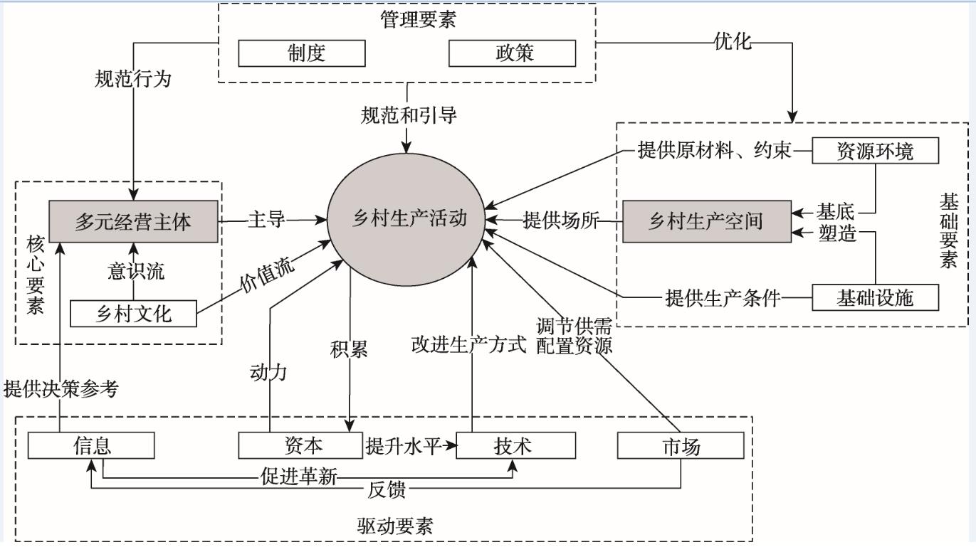
Rural production spatial system is a typical human-earth system, which has the characteristics of dissipative structure. Guided by the system theory and following the basic methods of system science, this study theoretically analyzed the connotation and elements of rural production spatial system, and divided the evolution process of rural production spatial system around the transformation of rural production relations. On this basis, it clarified the operation mechanisms of rural production spatial system. The study found that rural production spatial system is mainly composed of four sets of elements: basic elements (resources, environment, and infrastructure), core elements (multiple stakeholders and rural culture), driving elements (capital, technology, information, and market) and management elements (institutions and policies). According to the patterns of rural production relation change, economic system change, and urban-rural relationship change, the evolution process of rural production spatial system after the founding of the People's Republic of China was divided into four periods: land reform movement, agricultural mutual assistance and cooperation movement, people's commune movement, and household responsibility system. In different periods, the elements of rural production spatial system and their interrelated ways varied, and the characteristics of rural production spatial system are different. Rural production spatial system promotes its operation and development through supporting and restraining mechanisms, competition and cooperation mechanisms, and regulatory and feedback mechanisms. Future research will focus on examining the operation status of rural production spatial system, and diagnosing the dynamic mechanisms or obstacles of the system operation from the perspective of factor function, structural relationship, and coordination.
The spatial differentiation characteristics of the impact of high-speed rail on China's air passenger market is of important reference value for the coordinated development of the two modes of transportation. Using the standard deviation ellipse and traffic comprehensive utility analysis methods, this study analyzed the development status and spatial competition of the high-speed rail and air passenger transport market. The results show that: 1) The high-speed rail and aviation passenger markets have all formed a spatial pattern with Wuhan as the center. Compared with the high-speed rail, the development of the air passenger market area is more balanced; compared with the central cities of the eastern and western regions, the probability of passengers traveling with high-speed rail in the central cities of central China is higher. 2) The per capita time value is inversely proportional to the superiority distance of high-speed rail. The difference in superiority distance makes the high-speed rail and aviation passenger markets in central cities clearly different spatially. Based on the comprehensive utility perspective of traffic, for travels between most central cities in China, air travel is still the best choice. 3) The impact of high-speed rail on the air passenger transport market shows clear spatial differentiation. Most of the central cities in central China are the most affected, which is a key area for coordinating the development of high-speed railways and aviation. In the western region, due to the location conditions of transportation and the lagging development of high-speed rail, air transportation is dominant, and there is still a market gap in the aviation-dominated areas.
Examining the spatial agglomeration level and hierarchy differences of various urban elements and the distribution of diverse functional centers is significant for guiding the development and regulating the plans of the polycentric spatial structure of cities. City center is represented by various urban elements. It is difficult to fully identify and recognize the urban spatial structure by using a single data source. Thus, combining different types of data to deeply understand the status of urban internal development is necessary. This study used points of interest (POI), nighttime light, and road network data and adopted the local contour tree algorithm to identify the polycentric spatial structure in Wuhan City. The results show that: 1) The overall agglomeration level of various urban elements in the three towns of Wuhan is not balanced—the agglomeration level is higher in Hankou and Wuchang, and lower in Hanyang. 2) The development of the core area of Wuhan City is relatively mature. In the process of outward expansion, various urban elements tend to aggregate in local areas to form an urban center. 3) Considering the zonal development of Wuhan City, the functional distribution model of business-housing-industry corresponding to the ring roads of the city center was gradually established. The inner ring and the second ring regions have formed stable business service centers. Representative residential centers appeared in the multifunctional clusters near the second ring road. Similarly, Zhuankou and Wugang outside the third ring road led the development of industries, and are typical industrial centers.
The "Tanpeng canal", also known as "Tianwei path" or "Xianrenlong", was canalized and dredged by Pian Gao during the Xiantong period of the late Tang Dynasty. It was located in the sea area near the Jiangshan Peninsula south of Fangchenggang City in Guangxi Zhuang Autonomous Region, and is an important part of China's Maritime Silk Road. However, its geographic location is still a fair subject of speculation. Based on historical records and other materials, the authors explored the historical background, development process, and geographic location of the canal, which is of great significance for clarifying the historical and cultural value of Tianwei path and its important role in the maritime silk road. On the basis of historical literature review and investigation of the geographic background, we demonstrated the historical background of the canal's excavation, development process, and geographic location. Our research shows that: 1) The location of the Tanpeng canal should be in the sea area outside the White Dragon Tail at the southern end of the Jiangshan Peninsula. The excavation process of Tanpeng canal was the clearing of rocks in the sea area south of the White Dragon Tail. 2) The purpose of the development of the canal was to provide the Tang army in Annan with continuous and stable logistic supplies. The excavation of the canal took place between the eighth and ninth years of the Xiantong period of the Emperor Yi Zong. 3) Based on this history, the reef on which Pian Gao' canal passed through should be named Tianwei path, and the Tanpeng ancient canal on the peninsula should be renamed Tianwei path stone relics.
Since the 1980s, the critical theory of humanities and social sciences generates a new sub-discipline called critical toponymy, which focuses on the dissection of the cultural, economic, and political motivations of naming or renaming and pays close attention to the critical interpretation of the evolution of place-name landscape based on the perspectives of power competition and social relations. This sub-discipline gives an opportunity to account for the huge changes in the place-name landscape in China within the characteristic social context of market-oriented economy and rapid urbanization. It makes use of knowledge from multiple disciplines such as history, geography, management, linguistics, and folkloristics. As the produce and component of social memory, the application of social memory theory to the research of toponymy is of great theoretical and practical significance. But the role of social memory theory in toponymy has been overlooked for a long time. Meanwhile, place names have been considered intangible cultural heritage and many cities take diverse measures to preserve them. However, social memory is characterized by continuity, contemporaneity, and selectivity, which decide that not only the usage habitat and collective memory of local residents, but also the collective imagination of social groups can be ignored when naming or renaming place names. In other words, preserving historical place names and developing modern place names are equally important. Applying GIS spatial analysis and the theory of social memory, this study explored the spatiotemporal pattern and dynamic change of street names of the main districts in Nanjing City. It found that the most of newly-added street names distributed around the old urban area and the disappeared names clustered within the old urban area. The old south district has the highest density of both existent and disappeared street names. From the 1950s to the 1980s, the then newly-added street names were mainly found in the areas along the Yangtze River of Xiaguan District and districts surrounded by the Ming Great Wall, and from the 1990s they scattered at the periphery of the old city districts. Since 1911, the government came to control naming rights; as time went by, the leading role of the government and passivity of enterprises increased. The existing street names were mainly derived from surrounding residences, blessing, alien cultural sites, and natural landscape, which were not only inherited via the local culture of old districts, but also reflected the development prospect of the new districts. The street names based on religious beliefs, historical figures, economic activities, municipal facilities, and location in the city were more likely to die out due to the frequent change in social ideology and the city's functional space. The involvement of power and capital gave rise to many place names in modern style; the inertia of memory delayed the vanishing of old names; and the social construction of memory propelled the evolution of place names.
The level of urban public service provision directly affects the life quality of residents, and location and allocation of urban public service facilities are an important task of urban planning and development. In recent years, the concept of urban life circle has been paid increasing attention to in China, and various localities have aimed to create a perfect "community life circle" as a key task of urban governance. Using the open source map data and the urban network analysis (UNA) toolbox, this study analyzed the spatial difference of public service facilities in Shahekou District of Dalian City, and measured the number and type of reachable facilities to residents of 90 communities in the district. Then, an overall evaluation of each community was conducted. Finally, the optimal allocation of public service facilities was proposed. The results show that: 1) Public service facilities are unevenly distributed in Shahekou District of Dalian City. There are more facilities on the north side and fewer on the south side, showing a structure of one primary center and six secondary centers. The primary center is around the commercial area of Xi'an Road and the secondary centers are distributed in each subdistrict. 2) There is a large difference in the number of reachable facilities to residents—facilities on the north side of the Malan River are more than that of the south side, and there are more facilities in one or two areas in each subdistrict. 3) There are some differences in types of reachable facilities to residents, and more than 70% of the residents can reach all six types of public service facilities. The number of facility types reachable to residents on the west side of Xibei Road-Xinan Road-Wuyi Road is less than that of the east side. 4) Generally, in various communities reachable facilities are balanced and have small differences. However, there are still some communities that show large internal differences. According to the analysis, whether residents can access the various public service facilities is greatly affected by the distribution of facilities, the barriers of ground objects, and the closed degree of community. At the end of this article, we propose to build 15-minute community life circles with all needed facilities and easy to reach.
Residential differentiation refers to the spatial agglomeration of different social classes due to various socioeconomic backgrounds, housing preferences, and so on. Although rich literature has explored the relationship between residential differentiation and public health, few have combined urban geography with social psychology to analyze such relationship from the perspective of rational action. This study constructed a theoretical framework based on the theory of planned behavior. It took Nanjing City as the case study area and employed a structural equation model to analyze the complex influencing paths between residents' attitudes, subjective norms, perceived behavior control, physical activity intention, and actual physical activities by taking into account the unique residential differentiation context in China. This study collected 747 valid survey questionnaires from 31 neighborhoods in March-June 2018. The results show that there are significant differences in the socioeconomic characteristics and physical activity hours per week, perceived neighborhood environment, physical activity intention of respondents of traditional neighborhoods, working unit housing areas, affordable housing neighborhoods, urban villages, and commercial housing neighborhoods. Although urban villages and affordable housing neighborhoods have relatively less health resources and more lower income families than commercial housing neighborhoods, residents living in these neighborhoods perceive stronger health behavior control and show more positive health behavior intention and longer physical activity hours. Residents' physical activities are influenced by their perceived neighborhood environment and health behavior intention. Residents with more positive subjective norms are more satisfied with their residential environment, tend to positively evaluate benefits of physical activities, and consequently feel less barriers of doing physical activities. This can be explained by that the norms of residents' social environment affect residents' recognition effects of physical activities. When more people around are engaged in physical exercises, the surveyed residents think that physical activities are more important. The most significant factor affecting residents' intentions of physical activities and actual physical activities is the perceived strength of behavior control. Therefore, in addition to improving public opinion and residents' attitudes towards physical activities, it is necessary to reduce the perceived strength of behavior control and to improve the accessibility of health resources. This study provides some insights into actively intervening health behavior through improving built environments for health policy making.
Human habitat activity is the foundation of urban network. Examining the network structure of human habitat activities has important practical significance for promoting regional coordinated development. This study used Baidu Post Bar data to characterize urban human habitat activities, employed a social network analysis method to study the urban human habitat activity network system, and used quadratic assignment procedure (QAP) correlation and regression analysis to analyze the influencing factors of urban human habitat activity network structure. The results show that: 1) In terms of the overall network, the density of contact in the habitat activity area is 95.99%, and there are widespread connections among the cities in the three northeastern provinces. Urban connections can be divided into five types: global, common, relatively high, medium, and relatively low. 2) Urban human habitat activity network hierarchy at intraprovincial level is more obvious, and dominant cities and sub-dominant cities have not yet formed within the regional scope. 3) The network system of human habitat activities within the provinces is relatively complete, forming a relatively obvious urban network system. 4) In terms of influencing factors, tourism resources, administrative relations, spatial proximity, and income levels have significant impacts on the formation of urban human habitat activity networks.
With the emergence of global governance, non-state actors have increasingly attracted attentions around the world as a key participant of governance, although nation state is still the most important actor. As the Belt and Road initiative being promoted around the world, it becomes unavoidable to deal with the relationship with numerous non-state actors along the road. Many disputes between Chinese enterprises and foreign stakeholders are embedded in the complex social relations, which cannot be completely solved through official agreements or negotiations between the states. But non-state actors play an irreplaceable role in the generation and settlement of these problems. Geopolitics, particularly critical geopolitical theories (a key branch of geopolitics), and global governance theories have emphasized studies of diverse actors and their interpretation of international affairs, raising the necessity to examine the role and influence of non-state actors. Therefore, it is necessary to inspect their roles. However, the research on the geopolitics of non-state actors is under-developed, especially lacking the thinking from a spatial perspective. This article examines the impacts and the pathways of influence of non-state actors on the basis of existing studies to provide some references for understanding the role of non-state actors. First, this article examines the conception and classification of non-state actors. Then their geopolitical influences in space and pathways of these influences are explored, aiming to improve the framework for understanding non-state actors theoretically and instruct China's international cooperation in practice. We drew conclusions as follows. First, although non-state actors have not shaken the status of nation state on the world stage, they do have unique and irreplaceable roles to play in many issues. They not only act as the extension of states or governments on some occasions, but also make a breakthrough on traditional national border and territory. Second, they have both positive and negative impacts in the process of interacting with state actors in international spaces. The impact can be understood by the question that how non-state actors participate to change the security space, the institution space, the perception space, and the power space in the world. Third, the main approaches that non-state actors adopt comprise participating in and maintaining global governance, molding geopolitical imagination and perception, as well as adjusting the geopolitical space and borders. At last, drawn from what is found above, this article puts forward that in the ongoing global processes, Chinese government and enterprises need to attach importance to the power of various non-state actors and the coordination of their relations. When dealing with the relationship with them, it is counterproductive to simply define them as collaborators or challengers of the state actors. This article also proposes some ways to cope with the potential impacts of non-state actors, such as enhancing dialogue, expanding cooperation, improving management, staying alert of possible threats, and encouraging China's non-state actors to participate in international affairs actively.
This study examined the characteristics of spatial agglomeration and network power distribution of Beijing film industry. We mapped the Beijing film industrial network by choosing 115 films produced mainly by companies in Beijing based on relational data among film companies from the titles, acknowledgments, and campaign posters of the films. We assigned companies to 16 districts of Beijing and outlined the film industrial division network of districts in Beijing. Then we analyzed the network's characteristics of spatial agglomeration with kernel density analysis and measured network power distribution and spatial differences by social network analysis. The results show that: 1) There were four kinds of clusters. The first was at the juncture of southeastern Haidian District and northern Xicheng District. The second was located at the juncture of Dongcheng District and Chaoyang District with Sanlitun being the core, facing the Imperial Palace on the west and CBD on the east. The third was in the middle of Chaoyang District, covering the core area of the CBD-Dingfuzhuang international media industry corridor. The fourth was a film and television base—the Huairou Film & Television Industry Park, Beijing, China, whose remote location was decided by recent city planning. The former three, due to path dependence with market mechanism, were situated in the old city. 2) Beijing film industrial network power distribution was extremely unbalanced. Four state-owned film enterprises occupied the center of power. They had highly organizational and institutional proximity, being closely related to China Film Group Corporation. They formed the passage for capital, personnel, technology, and information exchange with dependence on the equity network within the China Film Group Corporation as well as controlled and coordinated operation of the whole film industrial network of Beijing in various ways, such as implementing industrial policies, exercising administrative supervision, taking control of releasing channels of films, and leading innovation in science and technology. The power center of the Beijing film industrial network was neither producers nor investment companies or non-profit organizations, but state-owned film companies with high organizational and institutional proximity. However, the power of state-owned enterprises came from monopolized political resources instead of market competition. With the gradual opening of the Chinese film market to the outside world, market mechanism will become more important. The policy advantage of state-owned enterprises is gradually vanishing. Thus it is of great importance to boost the development of state-owned enterprises and improve their efficiencies, which will lead to the sustainable development of film industry in Beijing. 3) Network power distribution of Beijing film industry had obvious differences in space. The network power focused on five districts of the city: Chaoyang District was the core region of the network, while Haidian, Dongcheng, Xicheng, and Huairou Districts were sub-centers and the other 11 districts were on the periphery.
Karst rocky desertification (KRD) is one of the most important environmental problems in the karst area of Southwest China. Studies of KRD process and its driving mechanism have been the hot spots in the related research fields and particularly, the impact of human activities on KRD remains to be further studied. In this study, Guanling County of Guizhou Province, where KRD is extremely serious, was selected as the research area. Using SPOT5/ALOS data in 2010, GF-1/ZY-3 data in 2015, and information from field investigations, the KRD spatial distribution and KRD change data were obtained by visual interpretation. Based on the examination of the spatiotemporal change characteristics of KRD, the impact of human activities such as land use, socioeconomic development level, and KRD restoration projects were analyzed. The results of this study show that: 1) The KRD land in Guanling County is dominated by moderate KRD, and it occupies more than 45% of the total land area in 2015. 2) The deteriorating trend of KRD in Guanling County has been effectively controlled. The area of KRD land is decreasing year by year, and most of the KRD land is in a stable state, especially that the severe KRD land and the extremely severe KRD land are clearly reduced, but some of the KRD land is still deteriorating. 3) Human activities play important roles on KRD change. First, land use types, especially shrub forest land, non-irrigated farmland, and forestry land have important influences on the change of KRD. Second, the higher the population density and GDP, the higher the degree of KRD and the less the effect of restoration. The KRD restoration projects in Guanling County have made remarkable achievements, where about one-third of the stable and improved KRD lands were a result of these restoration projects.
Due to its adverse impacts on urban ecological environment and the overall livability of cities, the urban heat island (UHI) phenomenon has become a major research focus in various interrelated fields. This study sought to evaluate the intensity of land surface temperature (LST) and the spatial pattern of source and sink landscape in the metropolitan areas of Wuhan City at a local scale, by examining urban surface temperature, landscape density of source and sink, contribution of source and sink, and landscape effect index. Landsat 8 OLI/TIRS data and geospatial approaches as well as statistical analysis were used to facilitate the analysis. The results shows that: 1) The UHI effect in Wuhan City has obvious seasonal changes and the intensity of UHI is strong in summer; the UHI generated by industrial agglomeration areas and economic development zones is more significant. 2) The mean LST of the city gradually declines along the urban-rural gradient after reaching the peak at about 8 km from the city center, showing a "barb-shaped" feature, which is closely related to the change of landscape density. 3) We found a significant strong correlation between mean LST and the density of source (positive) and sink (negative) landscape, and impervious surface is the main contributing factor of UHI. 4) With the same density of water and green spaces, water has greater potential of weakening the UHI effects. 5) Generally, when the areal ratio of sink-source landscape is greater than 0.89 (sink density greater than 0.47), the local landscape pattern has a mitigating effect on UHI. The more concentrated the local sink areas, the more significant the mitigation effect is.
The karst mountain areas are typical ecologically fragile regions in China. The vegetation is highly prone to degradation and is difficult to recover after that. In this study, we explored the change trend of climatic factors and distinguished the impact factors of annual NDVI change in karst mountain areas, by using stepwise regression, correlation analysis, and residual analysis. From 2002 to 2015, a warm and humid trend was found in the study area, but not significant at the P=95% level. The average annual changes of precipitation and temperature are in the range of -15.6-25.6 mm/a and -0.08-0.06 ℃/a, with an increasing rate of 7.9 mm/a and 0.00035 ℃/a respectively at the regional scale. During the study period, climate variability was the dominating factor of NDVI changes, which accounted for 95% of the annual variations, and the impact of precipitation on NDVI was slightly greater than that of temperature. The residual analysis of NDVI showed that the mean values of NDVI residual and its trend were 0.03 and 0.0007/a in the last 14 years, indicating that the positive effects of human activities were present. Human activities such as urbanization caused a large amount of cultivated land and forest to be occupied by construction land, thus had obvious negative effects on NDVI changes in Bijie, Anshun, Guiyang, Hechi, Liuzhou, and Baise. However, due to the implementation of ecological rehabilitation and reforestation projects, human activities had positive effects on NDVI changes in Liupanshui, Qianxinan, Zunyi, and Laibin.
Based on the 24 years (1993-2016) meteorological data including solar radiation and other related variables, this study analyzed the characteristics of surface solar radiation variation in Kunming City, and examined its influencing factors by using the methods of regression analysis, Mann-Kendall (M-K) abrupt test, wavelet analysis, and grey correlation degree analysis. The results show that surface solar radiation varied between 4620.21 MJ/m 2 and 6221.65 MJ/m 2, the maximum occurred in 2016 and the minimum occurred in 2008, and the annual mean was 5598.06 MJ/m 2. Annual mean solar radiation showed a fluctuating rising trend. The dry and wet seasons are distinct in Kunming City, and the maximum surface solar radiation appeared in dry season (November to April of the following year at 2825.22 MJ/m 2), but the minimum appeared in rainy season (May to October, at 2774.41 MJ/m 2). Maximum monthly variation of surface solar radiation in Kunming City appeared in April (604.75 MJ/m 2), and the minimum appeared in December (361.01 MJ/m 2). The difference of surface solar radiation between April and December was 243.74 MJ/m 2. According to the M-K abrupt test, the point of abrupt change appeared in 2014, but it is statistically insignificant. On the one hand, annual wavelet analysis detected a 15-year primary period of surface solar radiation. On the other hand, using seasonal wavelet analysis of surface solar radiation, the amplitude of surface solar radiation in dry season was stronger than in rainy season, but the primary periods are both 19 days. Finally, through grey relational analysis, the 24-year surface solar radiation was influenced by both human and natural factors. Precipitation is an important natural factor, but gross industrial output value is an important human factor influencing the surface solar radiation variation in Kunming City. Compared to the human factor, natural factor is the main contributor of the surface solar radiation variation in Kunming City.
Over the past four decades since China introduced the reform and opening-up policy, a rare large-scale population movement in human history has occurred. More than 200 million migrant workers left their hometowns to work in big cities, which has profoundly affected the politics, economy, society, and culture of contemporary China. With the transformation of economy, society, and population structure under the new normal conditions, China's labor geography is facing dramatic restructuring. The emerging industrial workers are constantly changing in the focus of rights and interests, the way of expression, and the effectiveness of practice, and quietly changing the existing labor relations with their unique spatial fix, then shaping their own economic geographical landscape. The study on geography of labor by neo-Marxist spatial political theory has undergone a transformation from class struggle geography to labor geography. Class struggle geography emphasizes that capital-dominated production of space originates from capitalist class struggle. In the late 1990s, Herod's theory of labor geography regards labor as the behavioral agent with the ability of "spatial fix" like capital. The perspective of agency has become an important trend in the study of labor geography in recent years. With the help of the production of space theory, this article attempts to construct a new research paradigm of labor geography based on the perspective of agency. The perspective of agency is critical, that is, workers' spatial practice has the ability to break through various structural constraints. First, in the process of daily spatial practice, the production and reproduction politics of struggle, livelihood politics of integration, and identity politics of creation constitute the dynamic mechanism of new workers' production of space. Second, a research path from new workers' production of space process to production of relation and labor regulation is put forward structurally. Around the core of agency, and driven by the external mechanisms of globalization and local processes, the three-dimensional mechanisms interact to form the basic process of three kinds of production of space of new workers. In this process, with the remodeling of material, social, and spiritual space, the new patterns of societal power relations are constantly derived, which will provide a new prospect for the realization of human-oriented labor market regulation mechanism and the construction of a harmonious society. Finally, this article suggests several future directions of research: the mechanism of new workers' production of space and its relationship with economic geographical reconstruction; regional differences of new workers' agency; the interaction between new workers' agency and local labor market regulation system; and agency of rural returned labor force.
Reducing CO2 emissions from transport is a major issue worldwide. It is also an important goal for sustainable urban and transport development. Using bibliometric methods, this article reviews and summarizes the current research situation and trends of global CO2 emissions from transport over the past two decades. On this basis, the article reviews and analyzes the literature on the driving forces of energy consumption and its related CO2 emissions, and the impacts of urban form and neighborhood built environments on CO2 emissions from transport at the national, city, and neighborhood scales, respectively. Our study found that most of the early national-scale studies were based on time-series data, using decomposition methods to explore the main driving forces of transport energy consumption. In recent years, further studies calculated CO2 emissions from transport with a "top-down" approach based on energy consumption data, and explored the impact of socioeconomic, urban form, and transportation development factors on CO2 emissions from transport by constructing panel data models. Early city-scale studies focused on whether compact cities are a low-carbon urban form, mainly using cross-sectional data and correlation analysis methods. In recent years, scenario forecasting, GIS spatial analysis, spatial regression, spatial simulation, and other methods have been further developed to explore the spatial differences of urban transport carbon emissions and their relationships with urban morphology and urban center distribution. For the neighborhood-scale studies, mathematical models were used to examine the effects of residents’ demographics and built environments on CO2 emissions, mainly based on cross-sectional and disaggregated questionnaire survey data. The built environment factors include population density, land-use mix, distance to employment sites or distance to urban centers, road network and intersection density, and the supply level of public transport. At the end of the article, research trends of influencing factors of CO2 emissions from transport in urban China are analyzed with respect to the three aspects of study data, methodology, and research contents.