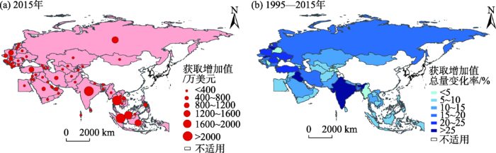
With the deepening of globalization, the global production networks have become the most important organizational platform for coordinating and organizing global production activities. The Belt and Road initiative marks the beginning of the era of inclusive globalization, and China will be more quickly and deeply integrated into the global production networks. In this context, whether there is a stable production network connection within the Belt and Road region and how deeply China participates in such network are very meaningful research topics. Based on the perspective of global production networks, this study conducted quantitative research with methods such as input-output analysis, value-added decomposition, and network analysis. The results show that: 1) During 1995-2015, the connection of the internal production networks of the Belt and Road region intensified continuously. 2) China is at the core and the first position in the value flow of the Belt and Road production networks, and this advantage was constantly strengthened. 3) The spatial distribution of China's added value sources have the characteristics of decreasing from east to west and high concentration in southeast, and Southeast Asia is the most important source of China's value added. 4) China's acquisition of value added from finished products along the Belt and Road is inefficient. Confronting the dilemma of "low-level lock-in", China needs to upgrade its value capture capability. According to the above results, China should increase spatial integration and maximize production cooperation with the Belt and Road region, at the same time, carry out industrial upgrading, improve the efficiency of value-added acquisition, and find new growth points for China's economic development.
With the advancement of economic globalization and regional integration, the demands of communica-tion and cooperation among regions increase rapidly. Relying on the unique advantages of speed, accessibility, and convenience, air transportation plays a significant role in the exchange of passenger and cargo among countries. The Belt and Road Initiative was proposed in 2013, which has attracted the attention of the world. Since then, the background of China's development has changed sharply, which brings new development opportunities for the expansion of the country's air transport network and can be shown in the following ways: 1) International tourism as a way of having vacation becomes more popular among people in China, largely due to the rapid increase of income. According to the statistics from China Tourism Administration, the number of outbound tourists increased from 98.2 million in 2013 to 130.51 million in 2017, contributing more passengers for international air transportation. 2) International trade also contributes more to China's prosperous international air transportation. 3) In the Belt and Road Initiative, facility connectivity was proposed as one of the most importance area of cooperation with countries of the region, and air transport network plays an important role in the realization of facility connectivity between countries. However, research on the change of China's international air transport since the proposition of the Belt and Road Initiative is still lacking. To fill this gap, this study analyzed the spatial distribution and change of international air transport network of China in terms of air routes, flights, and navigable cities based on the data of China's international air routes and flights in 2013 and 2018. The results show that: 1) On a whole, in the past five years, the Belt and Road Initiative has not altered the original pattern of China's air transport network, in which navigable cities formed the catchment centered on east and southeast Asia. 2) With regard to countries along the Belt and Road, their importance in China's air transport network is increasing and the numbers of routes and flights are increasing distinctively. 3) The main hub cities in China were Beijing, Shanghai, and Guangzhou in both 2013 and 2018, and more cities became secondary hub cities for different regions. New air transport routes and flights are operated in the existing navigable cities, showing that the direction of China's international air transport development is to deepen the connection with existing navigable countries and cities.
Along with the global strategy written into national strategy in 2000 and the Belt and Road Initiative proposed in 2013, China is accelerating the pace of investment for overseas ports. This study constructed a data base of examples of overseas ports investment by Chinese enterprises from 1978 to date, analyzed the spatial change of investment pattern on a global level, and clarified the features and pathway for Chinese enterprises entering overseas ports from the aspects of regional structure, participants, ownership change, and so on. It also examined the main entry patterns of overseas ports, internal relationship between different entry patterns, and correlation and shift between different patterns. Finally this article discussed the development mechanism of China's overseas port investment based on, in progression, why Chinese enterprises went global, why these enterprises invested where they did, and why these enterprises chose certain pattern. The results show that: The process of Chinese investment for overseas pworts can be divided into five development stages—before 2000, these overseas ports scarcely distributed in North Africa; from 2000 to 2008 China's investment for overseas ports tended to distribute in its surrounding areas; from 2009 to 2012 ports distribution turned to a global spread; from 2013 to 2016 overseas ports tended to concentrate as guided by the opening strategy; since 2007 ports distribution has remained overall stable. The changing process of distribution reflects three features: 1) Country distribution is dispersed, while these ports assemble significantly in Northwest European and Mediterranean at the navigation area scale. 2) The investors include large shipping enterprises, wharf operators, and infrastructure enterprises, among which the core enterprises for overseas ports' stock acquisition include China Ocean Shipping (Group) Company and China Merchants Steamship Company, and the core enterprise for overseas ports' infrastructure construction is China Harbour Engineering. 3) The number of overseas ports invested through stock acquisition began to increase rapidly since 2013 and as the investment process constantly deepening, overseas ports investment changed from equity participation to holding. Overseas ports entry patterns include infrastructure project construction, transfer of port managerial authority, acquisition of port's stock, and port management export. The influencing factors for overseas ports investment can be summarized as national economic development context, key opening-up strategy, global shipping pattern, spatial substitution, and enterprise self-development demand. Leading factors and their functions changed at different spatial scales and stages of development.
Under the background of the Belt and Road and the economic corridor of China, Mongolia and Russia initiatives, this study examined the accessibility level and its spatial differentiation of the Blagoveshchensk-Vladivostok railway in the southwest border area of the Far East Federal District in Russia. We first evaluated the accessibility level of the Blagoveshchensk-Vladivostok railway. Then, change after the future operation of the Blagoveshchensk-Vladivostok high-speed rail (HSR) was projected with two accessibility indicators—weighted average time and economic potential. Spatial differentiation of the accessibility change was presented using ArcGIS. Finally, the spatial differentiation of accessibility change was used to reveal the change and reshaping of spatial patterns in the southwestern border area of the Far East Federal District in Russia. The results are as follows: 1) The operation of the Blagoveshchensk-Vladivostok HSR will greatly improve the accessibility level in the southwestern border area of the Far East Federal District in Russia. It will shorten the journey time to eight hours from Blagoveshchensk to Vladivostok. After the operation of the HSR, the increase rate of economic potential is significantly higher than the decrease rate of weighted average travel time. The weighted average travel time of the nodes along the HSR will decrease by about 68%, while the economic potential of the nodes along the HSR will increase by around 1009%. 2) Before and after the operation of the Blagoveshchensk-Vladivostok HSR, accessibility strength of various federal subjects in the Russian Far East Federal District differs: the Primorsky Territory > the Khabarovsk Territory > the Jewish Autonomous Area > the Amur Region. However, accessibility improvement of the Primorsky Territory, the Khabarovsk Territory, and the Jewish Autonomous Area will be weaker than that of the Amur Region. Spatially, accessibility optimal element shows a decreasing trend from Vladivostok via Khabarovsk to Blagoveshchensk. Accessibility improvement of the nodes at the beginning and end of the Blagoveshchensk-Vladivostok line is stronger than those in the middle of the line. 3) Affected by the Blagoveshchensk-Vladivostok HSR, the gradual change and reshaping of regional spatial patterns will become increasingly more complicated in the southwestern border area of the Far East Federal District in Russia. Spatial extension and competition of influencing areas will intensify in the Blagoveshchensk-Vladivostok HSR distribution field. Spatial polarization of the Blagoveshchensk-Vladivostok HSR line will further enhance, and a new pattern of center-periphery spatial system will appear. The spatial pattern of four regional service centers (Vladivostok, Khabarovsk, Blagoveshchensk, and Birobidzhan) will evolve into the dual-core pattern of two regional service centers (Vladivostok and Khabarovsk). Spatial integration will occur among near-field cities. Regional coordinating effect will become obvious in Blagoveshchensk-Belogorsk, Khabarovsk-Birobidzhan, and Vladivostok-Artem.
Based on the imports and exports of intellectual property rights between countries (regions) from 2001 to 2015 and by mapping the global (external) and local (internal) technology trade networks, this study examined the technology trade pattern and change of the Belt and Road region from the global and local perspectives. We found that: 1) In the local (internal) technology trade network, internal technology imports pattern has changed from CIS (Commonwealth of the Independent States) and CEU (Central and Eastern Europe countries) dominated to East Asia countries dominated, and internal technology exports pattern has shifted from "one leading pole" of West Asia countries to the "three poles" of countries in ASEAN, West Asia, and East Asia. The Belt and Road region has a very low status in the internal technology supply chain. A large number of technologies need to be imported from the outside, but as a technology sales market, the Belt and Road region has significantly improved its position in the internal technology sales chain. 2) In the global (external) technology trade network, external technology imports pattern has changed from ASEAN dominated to East Asia dominated, and external technology exports pattern was always dominated by the ASEAN region with Singapore at the core. The Belt and Road region has significantly improved its position in the international technology sales market, but its position in the international technology supply chain was always very low. 3) With regard to the types of technology trade, most of the countries along the Belt and Road relied on internal technology trade to achieve technological complementarity, while the technology supply and sales of the countries with high technology trades were mainly relying on the outside. The regional technology trade network of the Belt and Road region has not yet been formed. At the end of the article, we recommend that China should increase its exports of technology to countries along the Belt and Road and build a regional technology cooperation network along the Belt and Road as soon as possible.
The Belt and Road initiative has become China's basic international policy. Keeping abreast of the social development trend of countries along the Belt and Road is crucial to ensuring the steady progress and successful implementation of the initiative. To this end, this study used the Global Data on Events, Location and Tone (GDELT) as a data source to obtain the full-text English news data in 25 countries along the Belt and Road in the past five years, and analyzed the social development trends of various countries by introducing topic models and combining an unsupervised method—the latent Dirichlet allocation (LDA) and a supervised method—labeled latent Dirichlet allocation (Labeled LDA) to mine the topics contained in the news data, and construct a social stability model. The study found that: 1) The social development trend of the countries along the Belt and Road is uneven, and the countries can be divided into four categories: Stable, such as Oman, Vietnam; Relatively stable, such as Uzbekistan, Iran; Moderate risk, such as Kuwait, Jordan, Pakistan, Myanmar; High risk, such as Syria, Afghanistan. 2) Through the spatiotemporal mining of news topics, hot spots can be effectively identified. For example, this study found that Andijon has an important influence on the social development and stability of Central Asia. 3) The supervised topic model could reveal Uzbekistan's economic and industrial structure, identify major social events, and discover its social security risks and trend. This method can effectively explore the spatiotemporal changes of news events, discover potential risks of countries, support real-time dynamic monitoring of the social development trends of countries along the Belt and Road, and provide auxiliary decision support for the implementation of the Belt and Road initiative, and thus has important application value.
Building Beautiful China is an important starting point for accelerating the reform of the ecological civilization system and realizing the sustainable development of the Chinese nation. At present, the country has set the timetable and roadmap of the construction of Beautiful China. It is of great significance to fully understand the current progress of Beautiful China research to guide future study. The current research on Beautiful China is at an exploratory stage, mainly focusing on the background and connotation of Beautiful China, the discussion of the index system, and the construction path. Among them, the connotation and theoretical basis of Beautiful China is the main body and focus of the present research, but a mature system is yet to be developed. The research of evaluation index system is in the exploration stage, and a unified understanding and standards have not been formed. The research content of the construction path is rather vague, and operability is limited. Future research needs to prioritize the following aspects. The first is to clarify the definition and connotation of Beautiful China, to build a theoretical system, and to answer the question of "what is". The second is to build a differential, development-oriented indicator system that is accessible, can be assessed, and can be implemented, to answer the question of "what to build". The third is to sum up local experiences, build a Beautiful China construction path system, and answer the question of "how to build".
Food is related to the national economy and people's livelihood. China's food system is facing many challenges. The reduction of cultivated land resources, criticality of environmental pressures, loss of agricultural workforce, and rapid transformation of consumer demand have placed higher demands on food system functions. At the present in China, food system research is insufficient and the research content is fragmented, which cannot meet the needs and challenges of the society today. This article provides an in-depth analysis of the evolving concept of food system, summarizing the conceptual issues and types and characteristics of food systems. It then examines the progress of food system research, which evolved from concepts to methods, from a linear to a systematic recognition of the concept, from economic activities to food landscapes, from phenomenon descriptions to spatiotemporal analysis, among others, to consolidate the core connotation of the food system. Under the guidance of the human-environmental relationship paradigm, the spatial paradigm, the philosophy of science paradigms, and the systematic science paradigm, and following the path of "pattern-structure-process-mechanism," the spatial and temporal patterns, factor structure, evolution process, and development mechanism of food systems are further explored. The aim of this study is to construct a geographical paradigm of food system research. It intends to provide some references for promoting basic research and practical applications of a food system perspective.
Plant phenology is an important indicator of the impact of global change on biological systems because it is very sensitive to climate change. Flowering phenology is of great importance since it represents the major developmental transition of plants from the vegetative to the reproductive stage. Many existing studies have identified the advancement in first flowering date in response to global warming. However, the mechanism of first flowering date dependency on climate change remains obscure. Plant hormones play pivotal roles in almost every aspect in plant life including flowering. To understand the regulation of plant flowering phenology in response to climate change by plant hormones, accurate and efficient measurements of plant hormones are required. In this review, the functions and possible links between plant hormones and the change in first flowering date were discussed. Also, recently developed methods for plant hormone detection were briefly summarized, providing scientific techniques for understanding the underlying mechanisms of plant phenology in response to environmental stimuli.
Urban tourism development has driven the boom of urban tourism research. Based on 377 Ph.D. dissertations majored in urban tourism between 2008 and 2017 from China and the United States, this study compared and analyzed the research structure and progress of urban tourism research in the two countries. A "space-theme" urban tourism research framework was proposed, and methods of industrial structure research were utilized. We found that there is no significant difference between the number of dissertations of these two countries, but disciplinary background and origin universities of the U.S. dissertations are more diverse than Chinese; the research structure of the dissertations from these two countries’ are similar. Chinese research was more concentrated, and more evenly distributed on different scales. With regard to the six research themes, scholars from the two countries focus on varied directions, but also share similar topics. Finally, based on the comparison between the two countries, we summarized the research structure, research space, research content, and research methods as well the prospect of future research.
In this study, the variability of the strong wind events in the Beijing-Tianjin-Hebei (BTH) region during the period 1979 to 2017 and its relationship with atmospheric circulation were analyzed, by employing the daily average wind speed records from the meteorological stations and the ERA-Interim reanalysis data. The analysis boreal winter months cover November to March of the following year. During 1979-2017, there were 556 strong wind events, and nearly 90% of them were dominated by northerly winds. The frequency of strong wind events has decreased significantly at a rate of -1.77 d·(10 a)-1 (P<0.1), and the mean wind speed for these events has weakened with a trend of -0.07 m·s-1·(10 a)-1 (P<0.05). The regional and hemispheric atmospheric circulation anomalies were also analyzed. It was found that the East Asian westerly jet has a significant positive correlation with the frequency of strong wind events. The North Atlantic region has a negative-positive stratospheric circulation anomaly distribution in the north-south direction, and its correlation coefficients with both the frequency and mean wind speed of strong wind events are close to 0.30. These analyses suggest that the wind variability in northern China is related to the regional atmospheric circulation over East Asia, the large-scale circulation in the northern hemisphere, and the upstream circulation in the North Atlantic
Under the new normal background, marine economy in China should develop with higher quality and effectiveness. Based on the framework of "knowldege/understanding-evaluation-construction-optimization", this study defined the connotation of marine economic growth quality and used a center-gravity model to analyze the spatial structure of marine economic growth quality in Liaoning coastal areas from 2000 to 2014. A spatial econometric model was used to examine the spatial effects and influencing mechanisms for marine economic growth. Recommendations for path control were proposed according to the extent of factor effects. The study found that: 1) Marine economic growth quality in Liaoning coastal areas exhibits a "core-circles" structure, forming a goose-straddle pattern with Dalian as the leading goose. A diamond-shaped gravitational flow promotes the concentrated development for the area. 2) There is a significant spatial agglomeration effect in the gravitational flow of marine economic growth quality in Liaoning coastal areas. The results of the spatial Durbin model show that the elements of marine capital, marine infrastructure, and marine industrial structure have become downstream mechanisms that promote marine economic growth quality in the area, and marine industrial structure is the main flow for marine economic growth quality, which has obvious influence in spatial agglomeration. However, marine talents have become a constraint flow on marine economic growth quality in Liaoning coastal areas, which restricts the flow of relevant elements. 3) Through the division of path effects, we proposed to strengthen the role of Dalian as the central area, formulate control measures for cities in the hinterland based on their roles and resource endowments in the regional system, and promote the process of coordination and integration in Liaoning coastal areas.
Hub-spoke network is an efficient network structure, which is helpful for reducing the cost of factor flow, improving efficiency, and increasing scale effect. Hub-spoke network consists of some hubs and spoke, where the hubs play the key role of circulating factors like people, capital, information, and so on, and the spoke receive the factors and transfer them in a specific way so that efficiency would be improved significantly. In this study, we took 37 counties and districts in the Wuhan metropolitan area as the research area and used the modified gravity model to calculate the spatial linkage strength in 1995, 2005, and 2015 between the 37 units. Then we mapped the hub-spoke network with networkx, an open source package of python and analyzed the changes. The results show that: 1) The strength of the linkages between towns and cities have gradually increased, and the pattern evolved from unipolar radiation to network integration. Meanwhile, the overall linkages present a core-periphery pattern centered on the main urban area of Wuhan City. The spatial linkage network developed synchronously with linkage strength, and network structure has become increasingly more compact. At the same time, the pivotal position of key nodes is becoming more prominent. 2) Key hub towns and linkage channels gradually developed around the main urban area of Wuhan City, forming some connecting rings covering the northeast and south of the main urban area of Wuhan City as the key connecting channels between key hub towns and spoke towns. 3) The structure of the overall linkage network consists of a high level hub, which is the main urban area of Wuhan City, some middle level hubs, which are the main urban areas of some prefecture-level cities, and the spoke towns in the Wuhan metropolitan area. The hub and spoke network structure has evolved from point-to-point to primary hub and spoke network and leveled hub and spoke network, but this structure is not perfect at present and is still in development.
Mental health has become one of the main health challenges that urban residents are facing in today's society. Previous research has proven that neighborhood built and social environments can influence mental health. However, related research was mainly focused on Western developed countries. Furthermore, previous research paid little attention to noise pollution and failed to consider the influences of neighborhood environment and noise pollution together. This may be one of the reasons that the results of previous research are inconsistent. Based on the health survey data of urban residents conducted in 2017 in 26 communities in Beijing, this study used a multilevel Logistic model to investigate the relationships between neighborhood environment (including built environment and social environment) and perceived noise pollution from various sources (including road traffic noise, railway and subway noise, store and restaurant noise, and housing renovation noise) and residents' mental health. The results show that residents' mental health is significantly affected by both the neighborhood environment and noise pollution level. As for neighborhood built environment, distance to main roads, which indicates traffic volume, as well as accessibility to health services and sports and recreational facilities, are significantly correlated with mental health. However, distance to public parks shows no significant relationship with residents' mental health. According to previous research, accessibility to parks is not equal to the actual use of them, and the latter relates to mental health more directly. In terms of neighborhood social environment, consistent with previous research, the number of greeting neighbors is positively correlated with mental health. Besides, neighborhood satisfaction also shows positive and significant association with mental health. The result suggests that it is necessary to promote community belongingness, neighborhood satisfaction, and social networks of residents through a variety of community activities and campaigns, in order to maintain mental health. Perception of trust and safety of neighborhoods show no significant association with mental health. Finally, housing renovation noise shows significant relationship with mental health, while other noise sources like road traffic, railways and subways, and stores and restaurants show no significant association with mental health. This result indicates that housing renovation noise has become the main source of noise affecting the mental health of Beijing residents, and it also reflects the rapid urban transition and large-scale mobility that happened in Beijing. Compared with previous research, this study combined neighborhood built and social environments as well as different sources of noise pollution to give a more comprehensive understanding on their influences on residents' mental health. This article also tried to explain the results in the context of rapid urban transition in China and to enrich the research findings for developing countries. However, there are still many areas in which more research is needed.