

冻土区分于其他土壤最显著的特征是冻土存在周期性冻融过程,冻土的周期性冻融和冻土退化会改变土壤水力性质[12]。如活动层的冻融过程直接影响青藏高原多年冻土冻结层上水的动态变化[13];季节冻土的冻融过程和季风气候带来的降水使得青藏高原水储量增加[14];冰川退缩、冻土退化导致雅鲁藏布江陆地水储量每年下降约11.59 mm[15];冻土和高寒草甸的退化导致高寒区域土壤持水能力下降[16]等。对于冻土水文要素的研究大多基于水热耦合模型,通过考虑温度和水分的相互作用来模拟冻土的水文要素变化过程。如刘杨李[17]基于WEP-COR模型模拟青藏高原河流源区多年冻土活动层之间的水热通量变化;张伟等[18]基于CoupModel模型模拟长江源区风火山区域多年冻土活动层水热迁移过程;秦越[19]改进GBEHM模型用来分析黑河上游冻土变化对土壤水热耦合传输的影响。一些水热耦合模型能够提高对冻土区域水文过程的模拟精度,但模型计算量大,所需要的多个参数难以确定[20⇓-22],且模型模拟的初始条件通常假设为均质土壤,很少考虑到冻土土壤属性会随冻土冻融过程发生变化。而水动力学模型HYDRUS-1D适用性广,广泛应用于生态农业、环境科学领域,用来表征土壤营养元素或污染物的溶质运移过程,模拟结果准确[20]。相比于其他陆面水文模型,HYDRUS-1D模拟所需要的土壤水力参数较易获取,且模型参数可调性高[23],能够准确地模拟土壤未冻水的变化趋势。此外,HYDRUS-1D还能考虑冻土冻融过程对土壤属性的影响,对冷季和暖季分别模拟。因此,本文选取HYDRUS-1D模拟黄河源区关键水文要素变化[24]。目前国内外对冻土水文要素的研究主要聚焦于土壤含水量、储水量和持水能力的变化,对冻土底部渗漏通量、冻土垂直剖面含水量变化的研究较少。本文利用HYDRUS-1D模型对季节冻土和多年冻土活动层的底部渗漏通量、垂直剖面含水量进行对比分析,力求研究清楚冻土未冻水运移的过程及特征。
黄河源区冻土分布广泛,是中国西北地区重要的生态环境保护区[25]。近年来,随着全球气候变化的加剧,冻土区域的水文过程受到很大影响[26-27],季节冻土和多年冻土的冻融过程会直接影响黄河源区的产汇流过程和水文要素变化[28]。黄河源区地理环境具有特殊性,研究季节冻土和多年冻土活动层关键水文要素的变化对于黄河流域的生态环境保护和可持续发展具有重要意义。本文着眼于黄河源区季节冻土和多年冻土活动层的土壤未冻水迁移过程,在考虑降水和蒸散发的外界影响下利用HYDRUS-1D模型进行模拟分析[29]。本文研究结果可为厘清黄河源区冻土冻融过程与关键水文要素变化之间的相互关系提供参考,也可为黄河流域的水资源管理和生态环境保护提供重要科学理论和决策依据[30]。
1 研究区域、数据与方法
1.1 研究区概况
图1
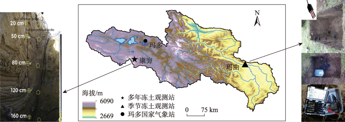
图1
黄河源区及观测站示意图
Fig.1
The source region of the Yellow River and observation stations
1.2 数据来源
分别在玛曲季节冻土观测站和康穷多年冻土观测站布设气象、冻土、水文等不同类型的观测仪器。在玛曲季节冻土观测站配置有一个METER EM50数据记录器和多个METER SMST探针。SMST探针每15 min记录一次土壤剖面温度、土壤含水量。在康穷多年冻土观测站配置有S-SMC-M005土壤湿度传感器和HOBO 压力式水位计,每4 h记录一次土壤含水量和地下水位。本文使用5 cm、20 cm、80 cm深度的土壤含水量数据对模型模拟结果进行验证。文中降水数据包括降雨和降雪。实际观测中康穷多年冻土观测站12月、1月部分降水数据有缺失,用国家气象信息中心(
1.3 HYDRUS-1D模型关键参数及模拟过程
1.3.1 水分运动方程
HYDRUS-1D模型基于Richards方程模拟多层冻土条件下的一维水分运动,用来分析冻土冻融过程中土壤未冻水、土壤储水量及底部渗漏通量的变化[24]。
式中:
式中:
1.3.2 时间离散化
HYDRUS-1D模型使用有限差分元方法进行数值求解,时间离散化的合理性是提升模型计算速度和稳定性的关键[36]。本文将冻土土壤水分下渗过程的初始时间步长定为0.1 d,最小步长定为0.001 d,最大步长定为5 d。
1.3.3 初始条件和边界条件
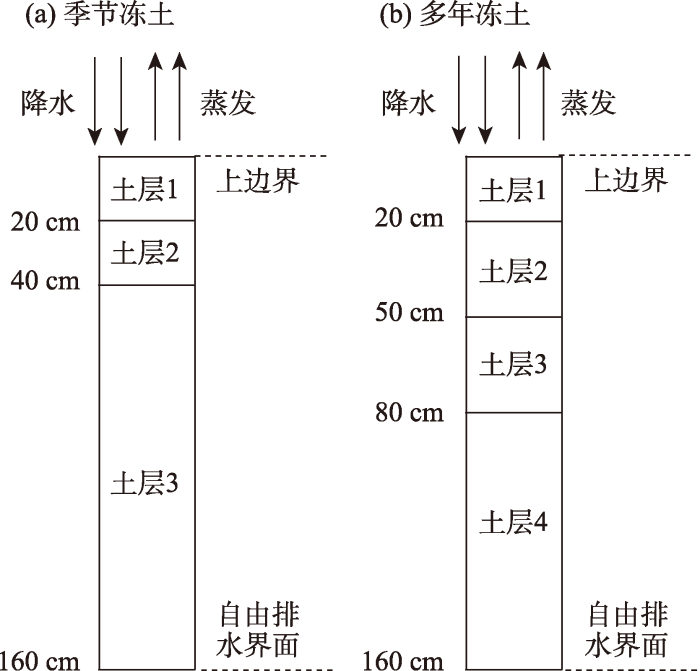
HYDRUS-1D模型仅考虑一维垂向运移时的土壤水分运动[37],模型模拟的一维垂直土柱简图见图2。玛曲观测站季节冻土一维土柱高160 cm,等间隔分为160个垂向网格单元,初始条件下分3层土壤(0~20 cm、>20~40 cm、>40~160 cm)。康穷观测站多年冻土一维土柱高160 cm,等间隔分为160个垂向网格单元,初始条件下分4层土壤(0~20 cm、 >20~50 cm、>50~80 cm、>80~160 cm)。土壤剖面的初始含水量用不同深度土壤实测含水量插值得到。HYDRUS-1D模型上边界为大气边界条件,由于观测站冬季降雪稀少,不单独输入降雪量,而输入日降水量(包括降雨和降雪)和日蒸散量。下边界(地下160 cm)默认为自由排水界面。
图2
1.4 输出关键水文要素
设置初始条件与边界条件后,利用HYDRUS-1D模型对黄河源区冻土水文要素进行模拟,本文主要分析不同深度的冻土土壤含水量、土壤储水量、底部渗漏通量和垂直剖面含水量的变化过程。土壤含水量指单位体积冻土内所含有未冻水的量,也称土壤含水率(cm3·cm-3)。由于HYDRUS-1D模型在“点”尺度上模拟,文中土壤储水量特指一维冻土土柱中所含有的液态水总量(用水深表示,单位 cm)。底部渗漏通量指单位时间内冻土中液态水渗漏穿过下边界的总量(cm·d-1)。文中提及的土壤含水量、土壤储水量、土壤水分等均为未冻水。
2 结果分析
2.1 季节冻土土壤水力参数的率定与验证
如图3所示,冷暖季不同深度土层土壤含水量模拟值与实测值对比结果表明:HYDRUS-1D模型对于季节冻土冻融过程水文要素变化模拟精度较高,模拟结果可信。冷季浅层土壤模拟效果优于深层土壤,5 cm、20 cm土壤含水量R2大于0.90,80 cm土壤含水量R2为0.67。暖季模拟效果不如冷季(R2为0.64~0.86)。
图3
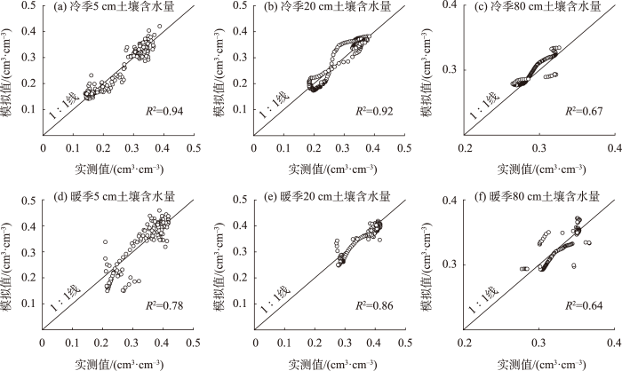
图3
冷季和暖季不同深度土壤含水量模拟值与实测值比较
Fig.3
Comparison of simulated and measured values of soil water content at different depths during the cold and warm periods
率定和验证后的土壤水力参数见表1。季节冻土的冻融变化会导致土壤水力参数发生变化。不同深度季节冻土残余含水率θr冷季小于暖季,饱和含水率θs冷季大于暖季。后续对冻土区域的研究中,充分考虑冻土冻融所引起的土壤水力参数变化对于提高水文模型模拟的精度有重要意义。
表1 季节冻土土壤水力参数
Tab.1
| 阶段 | 土层深度/cm | θr/(cm3·cm-3) | θs/(cm3·cm-3) | α | n | K/(cm·d-1) | l |
|---|---|---|---|---|---|---|---|
| 冷季 | 0~20 | 0.05 | 0.464 | 0.030 | 1.829 | 3.80 | 0.5 |
| >20~40 | 0.02 | 0.456 | 0.050 | 1.350 | 12.17 | 0.5 | |
| >40~160 | 0.01 | 0.412 | 0.027 | 1.440 | 4.33 | 0.5 | |
| 暖季 | 0~20 | 0.07 | 0.417 | 0.038 | 1.535 | 2.85 | 0.5 |
| >20~40 | 0.05 | 0.428 | 0.075 | 1.234 | 5.97 | 0.5 | |
| >40~160 | 0.01 | 0.367 | 0.016 | 1.270 | 4.56 | 0.5 |
2.2 季节冻土不同深度土壤含水量变化
图4是季节冻土冷季和暖季实测与模拟的土壤未冻水含量对比图。冷季模拟效果优于暖季,冷季RMSE均不超过0.023 cm3·cm-3,暖季RMSE为0.015~0.04 cm3·cm-3。在季节冻土开始冻结之前,HYDRUS-1D模型能够准确捕捉冷季5 cm土壤含水量从0.36 cm3·cm-3波动变化到0.42 cm3·cm-3的过程,进一步说明模型模拟效果较好。由于不同深度土层的渗透速率和储水能力不同,20 cm土壤含水量变化与5 cm相比在时间上有滞后,但整体变化趋势一致。研究中将表层5 cm土壤含水量变化的拐点作为季节冻土冻融过程的转折点,将冷季土壤未冻水年内变化过程划分为4个时期(图4左)。
图4
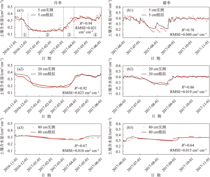
图4
冷季(左)、暖季(右)不同深度土壤含水量变化
注:图中①②③④分别指冻结开始时期(2016年11月18日至12月4日)、冻结稳定时期(2016年12年5日至2017年3月1日)、融化开始时期(2017年3月2日至3月27日)、完全融化时期(2017年3月28日至6月1日)。
Fig.4
Changes of soil water content at different depths during the cold period (left) and the warm period (right)
① 冻结开始时期(2016年11月18日至12月4日):处于融化状态的土壤由于负温开始冻结,土壤含水量迅速降低并达到最小值,5、20 cm土壤含水量迅速下降,深层80 cm土壤含水量变化不大。② 冻结稳定时期(2016年12年5日至2017年3月1日):持续的负温使得土壤完全冻结,土壤含水量稳定在低值不变,5、20、80 cm土壤含水量分别稳定在0.15、0.17、0.30 cm3·cm-3左右。③ 融化开始时期(2017年3月2日至3月27日):气温由0 ℃开始回升,处于冻结状态的季节冻土开始融化,此时降水增强,土壤含水量迅速上升。5 cm土壤含水量从0.15 cm3·cm-3上升到0.34 cm3·cm-3,20 cm土壤含水量从0.17 cm3·cm-3上升到0.36 cm3·cm-3,80 cm土壤含水量变化不明显。④ 完全融化时期(2017年3月28日至6月1日):季节冻土完全融化,土壤含水量主要受降水、蒸发等外界因素影响而波动变化。
HYDRUS-1D模型在暖季模拟效果不如冷季(图4右),模型虽然能够很好地模拟5、20 cm土壤含水量的整体变化趋势,但处理不好土壤含水量曲线拐点的高值和低值(在7月26日、8月5日模拟值高于实测值)。80 cm土壤含水量变化幅度小,稳定在0.35 cm3·cm-3左右。总的来说,不同深度土壤含水量冷季小于暖季,冷季季节冻土的冻融变化使得表层土壤含水量呈“U”形变化,暖季季节冻土完全融化,土壤含水量变化主要受降水等外部条件影响。
2.3 季节冻土水文要素变化分析
2.3.1 土壤储水量变化
如图5所示,季节冻土冷季与暖季土壤储水量变化差异明显。整体而言,冷季土壤储水量小于暖季,冷季土壤储水量在32~50 cm呈“U”型变化,暖季土壤储水量在49~52 cm波动变化。季节冻土冻结开始时期,土壤温度迅速下降,土壤快速冻结。已冻结的土壤水转化为冰,形成冻结带[40],使得土壤储水能力下降,土壤储水量减少。稳定冻结时期,由于季节冻土冻结带的存在,土壤储水量难以通过水分下渗的形式得到补充。这一时期,玛曲观测站日夜温差大,蒸发损失增加,导致土壤储水量不断减少。融化开始时期,已冻结的季节冻土逐渐消融,土壤中冻结的冰转化为未冻水,土壤含水量增加,地下水水位上升,使得土壤储水量也增加。完全融化时期,完全融化的季节冻土与非冻土的土壤属性相似,土壤储水量的波动变化主要受降水和蒸发等外界因素影响。
图5
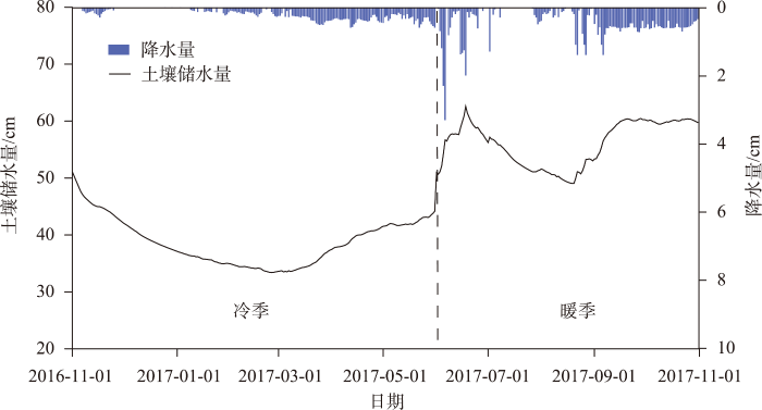
图5
季节冻土年内土壤储水量变化
注:图中冷季为2016年11月1日至2017年6月1日,暖季为2017年6月2日至10月31日。
Fig.5
Changes of soil water storage of seasonally frozen soil during the year
2.3.2 底部渗漏通量变化
季节冻土底部渗漏通量的变化情况如图6。底部渗漏通量在冷季冻结开始时期从0.62 cm·d-1逐渐减少至0.16 cm·d-1,这一时期土壤水开始冻结成冰,底部渗漏通量减少。冻结稳定时期,随着时间的推移,正在冻结的冰层继续增厚,在季节冻土层底部形成一个稳定的冻结带。冻结带的冰层厚度大、渗透能力低,有效地阻止了地下水下渗到底部,因此,这一期间底部渗漏通量进一步减少。直到季节冻土完全融化,冻结带中的冰完全融化成未冻水,渗漏通量随之增加。暖季季节冻土全部消融,之前冻结的土壤水迅速融化释放并下渗至底部,同时降水增多和降水入渗使得底部渗漏通量迅速增加,在2017年6月20日达到最大值(1.11 cm·d-1)。底部渗漏通量达到最大值之后,受降水强度、土壤质地、蒸散发、植被覆盖等因素的影响,各层土壤不易达到饱水状态。降水入渗还不足以使得各层土壤达到最大饱和含水量,因而底部渗漏通量又开始减少,在2017年9月11日减少到最小值(0.05 cm·d-1)。在2017年9月11日至11月11日期间,底部渗漏通量随降水波动变化。总的来说:冷季季节冻土冻结带的形成会阻碍土壤水分下渗,底部渗漏通量减少;暖季季节冻土完全融化,土壤水分正常下渗,底部渗漏通量主要受降水等外部条件影响。
图6
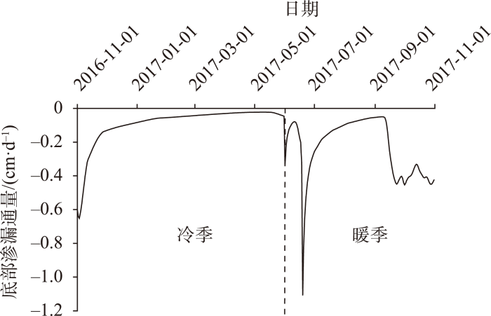
图6
季节冻土年内底部渗漏通量变化
Fig.6
Changes of bottom leakage flux of seasonally frozen soil during the year
2.3.3 土壤垂直剖面含水量变化
季节冻土冻结开始期间(2016年11月18日至12月4日)和融化开始期间(2017年3月2日至3月27日)逐日的土壤垂直剖面含水量变化情况见图7。能够清晰地看出:冻结开始期间土壤垂直剖面含水量逐渐减少(曲线从右至左,含水量逐渐减少),融化开始期间土壤垂直剖面含水量逐渐增加(曲线从左至右,含水量逐渐增加)。
图7
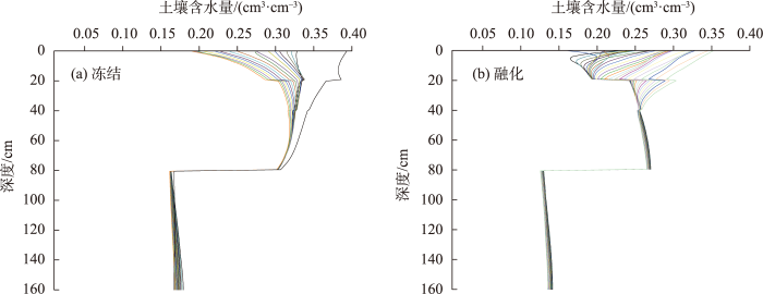
图7
季节冻土冻结开始期间(a)和融化开始期间(b)土壤含水量变化
注:图a中曲线从右至左依次为2016年11月18日至12月4日不同深度土壤含水量变化情况;图b中曲线从左至右依次为2017年3月2日至3月27日不同深度土壤含水量变化情况。
Fig.7
Changes of soil water content of seasonally frozen soil at the beginning of freezing (a) and thawing (b)
冻结锋面是冻土冻融过程中未冻水与冰的交界面[41]。冻结锋面上方有一定的水分压力梯度,土壤未冻水会不断流向冻结锋面来弥补水分压力梯度造成的水分损失[42]。季节冻土在20 cm处存在明显的冻结锋面(图7)。对80 cm上方土壤含水量变化进行分析,冻结开始期间土壤未冻水从20 cm土层上方和下方双向流向冻结锋面,20 cm处土壤含水量最高;融化开始期间土壤未冻水分别从冻结锋面上方和下方向土壤表层和深层流动,20 cm处土壤含水量达到最低值,且越接近地表土壤含水量越大。对>80~160 cm土壤含水量变化进行分析,深层土壤含水量变化不大。从图7能够清晰地看出:在地下80 cm处土壤含水量出现明显的“跃减(跃增)”现象,冻结开始期间由0.3 cm3·cm-3跃减到0.16 cm3·cm-3,融化开始期间由0.13 cm3·cm-3跃增到0.26 cm3·cm-3。
2.4 多年冻土活动层水文要素变化分析
为进一步明晰黄河源区冻土水文要素变化特征,本文补充康穷多年冻土观测站土壤储水量、土壤底部渗漏通量、土壤垂直剖面含水量变化进行对比分析。多年冻土模拟的时间范围为2016年9月29日至2017年9月29日,其中冷季为2016年10月25日至2017年5月7日,暖季为2016年9月29日至10月24日、2017年5月8日至9月29日。模拟过程中土壤水力参数所赋初值参考Cao等[43],对模型进行对比验证的土壤含水量数据来自中国科学院西北生态环境资源研究院冻土工程国家重点实验室。验证后的土壤水力参数见表2,HYDRUS-1D模型模拟结果较好(R2介于0.65~0.89,RMSE介于0.031~0.05 cm3·cm-3)。
表2 多年冻土土壤水力参数
Tab.2
| 阶段 | 土层深度/cm | θr/(cm3·cm-3) | θs/(cm3·cm-3) | α | n | K/(cm·d-1) | l |
|---|---|---|---|---|---|---|---|
| 冷季 | 0~20 | 0.09 | 0.50 | 0.041 | 1.53 | 22.50 | 0.5 |
| >20~50 | 0.07 | 0.48 | 0.042 | 1.56 | 28.10 | 0.5 | |
| >50~80 | 0.06 | 0.42 | 0.073 | 1.58 | 45.90 | 0.5 | |
| >80~160 | 0.06 | 0.41 | 0.064 | 1.61 | 80.78 | 0.5 | |
| 暖季 | 0~20 | 0.09 | 0.37 | 0.028 | 1.73 | 20.54 | 0.5 |
| >20~50 | 0.06 | 0.42 | 0.030 | 1.73 | 28.80 | 0.5 | |
| >50~80 | 0.07 | 0.29 | 0.037 | 1.65 | 49.86 | 0.5 | |
| >80~160 | 0.08 | 0.31 | 0.042 | 1.60 | 98.56 | 0.5 |
2.4.1 土壤储水量变化
图8为HYDRUS-1D模型模拟多年冻土活动层的年内土壤储水量变化。与季节冻土冻融过程类似,将土壤储水量的变化划分为4个时期:① 冻结开始时期(2016年10月25日至11月12日);② 冻结稳定时期(2016年11月13日至2017年5月7日); ③ 融化开始时期(2017年5月8日至6月6日);④ 融化最大时期(2017年6月7日至9月29日)。与季节冻土冻融变化过程中 ④ 完全融化时期不同,由于多年冻土底部冻土层并未完全融化,多年冻土冻融变化过程中第四阶段为 ④ 融化最大时期。
图8
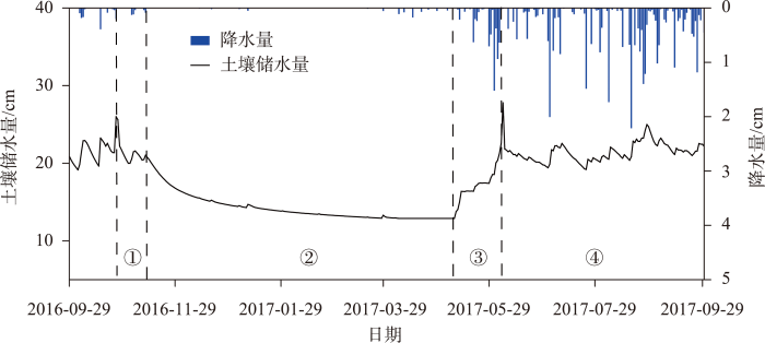
图8
多年冻土年内土壤储水量变化
注:图中①②③④分别指冻结开始时期(2016年10月25日至11月12日)、冻结稳定时期(2016年11月13日至2017年5月7日)、融化开始时期(2017年5月8日至6月6日)、融化最大时期(2017年6月7日至9月29日)。
Fig.8
Changes of soil water storage of permafrost during the year
分别对多年冻土冻融变化4个时期的土壤储水量进行分析:① 冻结开始时期,多年冻土开始冻结,土壤储水量由26 cm迅速下降并达到弱饱和状态。② 冻结稳定时期,康穷观测站气温低且降水稀少,多年冻土活动层处于稳定冻结阶段。活动层冻结的土壤水阻碍水分下渗,土壤储水量主要以蒸发的形式损失,土壤储水量有微弱的减少。③ 融化开始时期,气温开始升高,多年冻土活动层开始融化,原先冻结在活动层的水被释放出来,土壤储水量迅速上升达到28 cm。④ 融化最大时期,多年冻土活动层完全融化,地下水位上升,土壤储水量在19~24 cm之间波动变化。这一时期康穷观测站属于雨季,降水显著增多。从图8能够看出土壤储水量波动变化的峰值稍微迟滞于降水最大值出现的时间,进一步说明降水是影响多年冻土土壤储水量变化的一个重要因素[44]。
2.4.2 底部渗漏通量变化
图9为多年冻土活动层底部渗漏通量的变化情况,底部渗漏通量的变化也分为冻结开始时期、冻结稳定时期、融化开始时期、融化最大时期4个时期。冻结开始时期,由于多年冻土双向冻结的特性,尽管有少量降水抵达地表,已经开始冻结的活动层会阻碍水分下渗,底部渗漏通量在波动变化后逐渐减少。冻结稳定时期,完全冻结的活动层形成一道“隔水层”,活动层底部阻碍水分下渗。这一期间康穷降水稀少,低含量的土壤未冻水还要以蒸发的形式损失,基本渗透不到下边界,因此底部渗漏通量减少到0后稳定不变。融化开始时期,多年冻土活动层中的冰迅速融化成水,地下水位上升,未冻水通过土壤孔隙下渗,底部渗漏通量迅速增加至0.24 cm·d-1。融化最大时期,土壤温度高于0 ℃,多年冻土活动层完全融化,同时降水在土壤中垂直入渗以壤中流的形式产生底部渗漏通量,底部渗漏通量迅速增加并波动变化。此外,多年冻土的冻融过程一定程度上会改变土壤的孔隙结构,导致土壤孔隙的连通性增强或减弱,土壤水分下渗能力升高或降低,从而影响底部渗漏通量变化。
图9
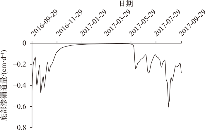
图9
多年冻土年内底部渗漏通量的变化
Fig.9
Changes of bottom leakage flux of permafrost during the year
2.4.3 土壤垂直剖面含水量变化
多年冻土活动层冻融过程的土壤垂直剖面含水量变化情况见图10。土壤含水量变化与季节冻土相似,冻结开始期间(2016年10月25日至11月12日)土壤垂直剖面含水量逐渐减少,融化开始期间(2017年5月8日至6月6日)土壤垂直剖面含水量逐渐增加。多年冻土活动层冻融过程中同样存在冻结锋面。冻结开始期间土壤水双向流向冻结锋面,20 cm处土壤含水量最高;融化开始期间土壤水由冻结锋面向土壤表层和深层流动,20 cm处土壤含水量更低,且越接近地表土壤含水量越大。与季节冻土不同,多年冻土由于活动层底板的存在,80 cm处并没有出现“跃减(跃增)”现象。
图10
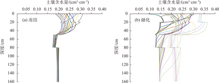
图10
多年冻土冻结开始期间(a)和融化开始期间(b)土壤含水量变化
注:图a中曲线从右至左依次为2016年10月25日至11月12日不同深度土壤含水量变化情况;图b中曲线从左至右依次为2017年5月8日至6月6日不同深度土壤含水量变化情况。
Fig.10
Changes of soil water content of permafrost at the beginning of freezing (a) and thawing (b)
3 讨论
本文利用HYDRUS-1D模型的冻融模块模拟分析黄河源区冻土冻融过程对关键水文要素变化的影响。在对VG模型土壤水力参数进行率定与验证的过程中,发现将年内模拟时间段分冷季和暖季,模拟效果更好。事实上,冷季冻土冻融过程中土壤水、热变化复杂,不同土层土壤属性(如质地、孔隙度、水分保持能力等)均会发生变化。而土壤水力参数取决于土壤的孔隙度、容重等等[45]。在后续对冻土区域的研究中,区分冻土冻融变化时期与冻土不发生冻融变化的时期对于提高水文模型的模拟精度具有十分重要的意义。
对季节冻土土壤含水量变化进行模拟,模拟效果冷季优于暖季。原因是冷季降水稀少,模型输入的上边界条件简单;而暖季降水波动变化大,输入上边界条件后模型难以精细地捕捉到后续降水、蒸发的变化。无论是季节冻土还是多年冻土,土壤含水量变化都能清晰地分为冻结开始时期、冻结稳定时期、融化开始时期、完全融化时期(融化最大时期),这与曹伟等[44]的研究结论一致。此外,由于冻土冻融变化特征,表层季节冻土与多年冻土活动层土壤含水量呈“U”形变化,深层则变化不明显。
分别讨论季节冻土与多年冻土活动层水文关键要素变化过程与特征:
(1) 对比季节冻土与多年冻土土壤储水量变化,冻结稳定时期季节冻土储水量减少得比多年冻土快,原因是季节冻土冻结带相比多年冻土活动层阻水能力稍弱,仍有少数土壤水下渗。
(2) 对比季节冻土与多年冻土活动层底部渗漏通量变化,冻土冻结期间底部渗漏通量都不断减少,说明逐渐冻结的土壤水会阻碍水分下渗。而多年冻土由于活动层底板的存在,底部渗漏通量维持在0。年内冻结期间,冻土冻融变化会改变土壤孔隙结构,导致土壤孔隙的连通性增强或减弱,影响底部渗漏通量变化。在非冻结期间,季节冻土、多年冻土与非冻土的土壤属性相似,土壤储水量、底部渗漏通量主要受降水强度、土壤质地、蒸散发、植被覆盖等外部因素影响。
(3) 对比季节冻土与多年冻土垂直剖面含水量变化,冻土冻结开始期间含水量逐渐减少,融化开始期间含水量逐渐增加。浅层冻土稳定性不如深层,因此,土壤含水量变化幅度大。与多年冻土不同,季节冻土地下80 cm处土壤含水量出现明显的“跃减(跃增)”现象。原因可能是:冻结开始期间季节冻土双向冻结,随着时间的推移,冻结深度逐渐加深,冻结带的下限也随之下降。当冻结带的下限到达80 cm时达到最大冻结深度,土壤中的未冻水绝大部分冻结成冰,土壤含水量“跃减”。同理,融化开始期间80 cm处冻结水迅速释放,土壤含水量“跃增”。
4 结论
基于HYDRUS-1D模型,本文对黄河源区季节冻土和多年冻土活动层年内冻土水文关键要素变化进行分析。结果表明:
(1) 冻土冻融循环会导致土壤水力参数发生变化。季节冻土和多年冻土饱和含水率θs冷季大于暖季;对残余含水率θr而言,季节冻土不同深度冷季均小于暖季,而多年冻土仅深层冷季小于暖季。
(2) 季节冻土与多年冻土活动层冻融过程中土壤含水量变化过程相似,年内冻结期间土壤含水量呈“U”形变化,待完全融化后土壤含水量主要受降水等外部因素影响。对季节冻土而言,不同深度土壤含水量冷季小于暖季。
(3) 冻结稳定时期季节冻土储水量减少比多年冻土快,二者底部渗漏通量都不断减少,而多年冻土由于活动层底板的存在,底部渗漏通量减少到0 后保持不变。
(4) 季节冻土与多年冻土活动层在地下20 cm处有冻结锋面。冻结开始期间土壤水双向流向冻结锋面,融化开始期间土壤水由冻结锋面双向流出。
参考文献
最近十多年来冰冻圈加速萎缩: IPCC第六次评估报告之冰冻圈变化解读
[J].
DOI:10.7522/j.issn.1000-0240.2021.0090
[本文引用: 1]

政府间气候变化专门委员会(IPCC)于2021年8月发布了第六次评估报告第一工作组报告《气候变化2021:自然科学基础》。该报告基于最新的观测和模拟研究,评估了冰冻圈变化的现状,并采用CMIP6模式对未来变化进行了预估。报告明确指出,近十多年来冰冻圈呈现加速萎缩状态:北极海冰面积显著减小、厚度减薄、冰量迅速减少;格陵兰冰盖、南极冰盖和全球山地冰川物质亏损加剧;多年冻土温度升高、活动层增厚,海底多年冻土范围减少;北半球积雪范围也在明显变小,但积雪量有较大空间差异。冰冻圈的快速萎缩加速海平面的上升。未来人类活动对冰冻圈萎缩的影响将愈加显著,从而导致北极海冰面积继续减少乃至消失,冰盖和冰川物质将持续亏损,多年冻土和积雪的范围继续缩减。报告也提出,目前冰冻圈研究仍存在观测资料稀缺、模型对各影响因素的敏感性参数和过程描述亟需提升、对吸光性杂质的变化机制认知不足等问题,从而影响了对冰冻圈变化预估的准确性,未来需要重点关注。
The rapidly shrinking cryopshere in the past decade: An interpretation of cryospheric changes from IPCC WGI Sixth Assessment Report
DOI:10.7522/j.issn.1000-0240.2021.0090
[本文引用: 1]
The Working Group I report of the Sixth Assessment Report (AR6) of the Intergovernmental Panel on Climate Change (IPCC) was released in August 2021. Base on updated and expanding data, AR6 presented the improved assessment of past changes and processes of cryosphere. AR6 also predicted the future changes using the models in CMIP6. The components of cryosphere were rapid shrinking under climate warming in the last decade. There were decreasing trends in Arctic sea-ice area and thickness. Sea-ice loss was significant. The Greenland Ice Sheet, the Antarctic Ice Sheet and all glaciers lost more mass than in any other decade. Global warming over the last decades had led to widespread permafrost warming, active layer thickness increasing and subsea permafrost extent reducing. Snow cover extent in the Northern Hemisphere also decreased significantly. However, the variations of snow depth and snow water equivalent showed great spatial heterogeneity. The rapid shrinking of the cryosphere accelerated the global mean sea level rise. The impact of human activities on cryosphere will become more significant in the future. The Arctic sea-ice area will decrease, and the Arctic Ocean will likely become practically sea ice-free. The Greenland Ice Sheet, the Antarctic Ice Sheet and glaciers will continue to lose mass throughout this century. Permafrost and Northern Hemisphere snow cover extent will continue to decrease as global climate continues to warm. In addition, there are still uncertainties in the prediction of cryosphere due to the absence of observations, the poor sensitivity of models to the components and processes of cryosphere, and the inexplicit represent of the mechanism of light-absorbing impurities. More attentions should be paid on these issues in the future.
1990—2020年间念青唐古拉山中段北坡边坝地区冰川变化及气候响应
[J].
DOI:10.18306/dlkxjz.2021.12.008
[本文引用: 1]
念青唐古拉山作为青藏高原东南缘重要山古冰川分布区,受季风影响,各区域冰川变化特征差异明显。论文通过Landsat TM/ETM+/OLI资料、ASRTMGDEM与气象数据,采用比值—阈值法、目视解译和VOLTA模型,结合实地考察,对1990—2020年间念青唐古拉山中段北坡边坝地区现代冰川进退状况、面积变化、冰储量变化以及冰川变化对气候变化响应特征进行研究。结果表明:① 1990—2020年5条冰川(玉贡拉冰川、玛拉波冰川、祥格拉冰川、孔嘎冰川、贡日—庚东冰川)末端高程逐渐升高,面积和冰储量分别减少30.38 km<sup>2</sup>和4.64 km<sup>3</sup>,总体缩减并呈现加速趋势。② 冰川冰储量减少0.14~1.92 km<sup>3</sup>,总体变化率为0.40%·a<sup>-1</sup>。2020年上述5条冰川储量占1990年冰川储量的比例分别为0.70、0.99、0.98、0.91和0.82,显示出冰川规模越大,在短时间尺度的变化量越小。③ 气象数据分析显示,1990—2020年研究区冰川变化受气温升高主导,平均气温变化率为0.51 ℃。水热组合呈现温度升高—降水减少,且在最后10 a日益显著,预测未来冰川变化仍受气温控制并呈加速退缩趋势。④ 区域对比研究表明,念青唐古拉山冰川面积变化总体呈退缩状态,但各区域冰川变化特征差异明显。同时,不同研究方法对同一冰川区冰储量模拟结果相差较大,相对误差范围为34.45%~115.49%,精确的冰储量可对比研究方法仍有待进一步研究。
Glacier change and response to climate in the northern slope of the middle Nyainqêntanglha Mountains during 1990-2020
基于水热变化的青藏高原土壤冻融过程研究进展
[J].
DOI:10.18306/dlkxjz.2020.11.014
[本文引用: 1]
青藏高原近地层土壤冻融过程是高原地表最显著的陆面特征之一,也是判断冻土发育、存在以及反映气候变化的重要指标。近地层土壤昼夜、季节性的冻结、融化会导致青藏高原陆—气间能水平衡的变化甚至异常,从而显著影响高原地表水文过程、生态环境、碳氮循环以及高原及其周边区域的天气和气候系统。论文从观测、模拟以及对气候的影响3个角度来探讨1990年以来青藏高原土壤冻融过程的最新研究进展。结果表明:① 在一个完整的年冻融循环过程中,近地表各层土壤大体都经历了夏季融化期、春秋季融化—冻结期、冬季冻结期4个阶段。受局地因素的影响,不同站点的冻结或消融起止时间、速率、类型均有差异。② 多年冻土区和季节冻土区的日冻融循环过程差异较大,主要体现在日冻融循环持续时间上。③ 不同陆面模式都可以很好地抓住冻融过程中物理量的时空变化,但都需要针对高原陆面过程的特点进行参数化改进。④ 规避不稳定的迭代计算并根据热力学平衡方程确定冻融临界温度可以改进不合理的冻融参数化方案。基于已有研究回顾,发现增加高质量的观测站,利用卫星遥感等多种手段来反演高原土壤冻融过程以及加强陆面模式与区域气候模式和全球气候模式的耦合,并立足于高原冻融过程的特点发展相适应的参数化方案以及模拟结构的调整,能够有助于高原冻融过程的模拟。
Soil freezing-thawing processes on the Tibetan Plateau: A review based on hydrothermal dynamics
DOI:10.18306/dlkxjz.2020.11.014
[本文引用: 1]
The freezing and thawing processes of near-surface soil are one of the most significant physical characteristics of the land surface on the Tibetan Plateau (TP), as well as an essential index for estimating the existence and development of the permafrost and reflecting the climate change. The seasonal and diurnal freezing-thawing processes of the near-surface soil cause the changes and even anomalies of water and energy balance between the land and the atmosphere on the TP, and thus significantly affect surface hydrological processes, ecological environment, carbon and nitrogen cycles, and the weather and climate system on the plateau and of the surrounding areas. This article discusses the observational and simulated changes and the impact on the climate by reviewing latest research progress in soil freezing-thawing processes (SFTPs) over the past 20 years. Our review shows that: 1) During a complete annual freezing-thawing cycle, each layer of soil generally experiences four stages: summer thawing period, autumn thawing-freezing period, winter freezing period, and spring thawing-freezing period. Due to the influence of local factors, the SFTPs show differences in the start and end dates, rate, and type of change. 2) Diurnal freezing-thawing cycles show large differences between the permafrost regions and the seasonally frozen regions, which are mainly reflected in the duration of diurnal freezing-thawing cycles. 3) Although different land surface models (LSMs) can well capture the spatiotemporal variations of physical quantity of SFTPs, all of them need to be revised according to the characteristic of LSMs of the TP. 4) Unreasonable freezing-thawing model parameterization schemes can be improved through avoiding the unstable iterative computation and determining the critical freezing-thawing temperature according to the thermodynamic equilibrium equation. According to the review of existing research, adding high-quality observation stations, using satellite remote sensing data to retrieve SFTPs and deepen the coupling of LSMs with regional climate models and global climate models, developing parameterization schemes that are suitable for SFTPs of the TP, and adjusting the model structures can be helpful for the simulation of SFTPs on the TP.
Responses of permafrost to climate change and their environmental significance, Qinghai-Tibet Plateau
[J].
Increasing winter baseflow and mean annual streamflow from possible permafrost thawing in the northwest territories, Canada
[J].
Climatic and associated cryospheric, biospheric, and hydrological changes on the Tibetan Plateau: A review
[J].
The environmental consequences of permafrost degradation in a changing climate
[J].DOI:10.1016/j.scitotenv.2017.10.285 URL [本文引用: 1]
Progress in permafrost hydrology in the new millennium
[J].DOI:10.1002/ppp.v19:2 URL [本文引用: 1]
水文学研究进展与展望
[J].
DOI:10.18306/dlkxjz.2018.01.005
[本文引用: 1]
水文学是研究地球上水的起源、存在、分布、循环运动等变化规律,并运用这些规律为人类服务的知识体系。水文学研究经历了由经验到理论、由简单过程到复杂系统、由定性描述到定量模拟的发展历程,其学科体系演进与科学技术进步及社会发展需求紧密联系,并由此衍生出诸如生态水文学、气象水文学、冰冻圈水文学、遥感水文学、同位素水文学、城市水文学、社会水文学等多种交叉研究领域与分支学科。当今水文学研究在水文多尺度观测、陆面—水文—社会耦合模拟及多源观测—模型同化技术等领域取得显著进展,水文学研究的广度和深度不断拓展。未来水文学研究将面向陆地水文循环的变化规律及其效应,重点关注水文循环变化特征和机理、水文循环变化趋势预估及水文循环变化的自然和社会影响等前沿课题;从原有就水论水研究思路转向在自然地理综合分析框架下以水循环为纽带开展的多尺度、多过程集成研究。
Progress and prospect of hydrological sciences
DOI:10.18306/dlkxjz.2018.01.005
[本文引用: 1]
Hydrology is the science that describes the continuous movement of water, the related biogeochemical and geophysical processes, and their interactions with the environment. Hydrology research has evolved from experience-based to theories, from single process to complex systems, and from qualitative interpretations to quantitative models. The progress and evolution of hydrology has been intimately intertwined with the scientific and technological progresses and socioeconomic development, which creates many branches and interdisciplinary areas of hydrology, such as ecohydrology, hydrometeorology, cryosphere hydrology, hydrologic remote sensing, isotope hydrology, urban hydrology, and socio-hydrology. Hydrology research has made notable progress in the fields of multi-scale observations, coupled land surface-hydrology-society modeling, and multi-source data and model assimilation techniques, which further expands the connotation of hydrological study. In the future, hydrology research will focus on the characteristics and mechanism of the changes of water cycle, prediction of the changes of water cycle, and natural and social impact assessment of the changes of water cycle, in order to offer sustainable solutions to water security. In summary, the research paradigm of hydrology would shift from the traditionally self-focused approaches to the emerging integrated approaches that focus on all the water-related processes across multiple scales and sectors in the earth system.
Permafrost degradation on the Qinghai-Tibet Plateau and its environmental impacts
[J].DOI:10.1002/(ISSN)1099-1530 URL [本文引用: 1]
青藏高原多年冻土区活动层水热特性研究进展
[J].
DOI:10.7522/j.issn.1000-0240.2020.0027
[本文引用: 1]
青藏高原多年冻土作为我国冰冻圈的重要组成部分, 其水热状况是影响寒区生态环境、 陆气间水热交换、 气候变化以及地面路基建设等的重要因素。为增进对青藏高原多年冻土区活动层水热特性的认识, 对影响活动层水热特性的主要因素以及主要研究方法做进一步梳理, 并指出了当前研究中的不足。研究认为, 气象条件、 植被覆盖度、 土壤性质、 积雪等是影响多年冻土区活动层水热过程的主要因素, 目前针对活动层水热特性的研究主要通过对站点实测资料分析和模型模拟等方式展开。未来工作的重点应放在改进适合于高寒山区的陆面模式以及增强水热动态过程与气候系统的相互作用上。
A review on the development of study on hydrothermal characteristics of active layer in permafrost areas in Qinghai-Tibet Plateau
DOI:10.7522/j.issn.1000-0240.2020.0027
[本文引用: 1]
As an important part of China’s cryosphere, the hydrothermal condition of the permafrost on Qinghai-Tibet Plateau is an important factor affecting the ecological environment of cold regions, the exchange of water and heat between land and air, climate change and the construction of embankment. In order to enhance the understanding of the hydrothermal characteristics of the active layer in permafrost regions of the Qinghai-Tibet Plateau, this paper summarizes the main factors that affect the hydrothermal characteristics of the active layer and the main research methods, and points out the main problems in the current research. It is believed that meteorological conditions, vegetation coverage, soil properties and snow cover are the main factors affecting the hydrothermal process of the active layer. At present, researches on the hydrothermal characteristics of the active layer are mainly carried out through the in situ measured data and model simulation. The future work should focus on improving the land surface model suitable for alpine mountains and enhancing the interaction between hydrothermal dynamic processes and climate system.
青藏高原多年冻土区土壤冻融期间水热运移特征分析
[J].
Characteristics of hydro-thermal transfer during freezing and thawing period in permafrost regions
Seasonal dynamics of suprapermafrost groundwater and its response to the freeing-thawing processes of soil in the permafrost region of Qinghai-Tibet Plateau
[J].DOI:10.1007/s11430-014-5009-y URL [本文引用: 1]
青藏高原区域水储量变化的GRACE RL06和TRMM联合反演
[J].
DOI:10.11947/j.AGCS.2020.20200026
[本文引用: 1]
近10年来,独立成分分析(ICA)逐渐被引入地球时变重力场的成分提取中。ICA因其提取成分的独立性,解决了运用主成分分析(PCA)时各提取成分仅互不相关的这一关键性问题。基于负熵的FastICA算法是常见的ICA方法,该算法的收敛较梯度算法快,且负熵的稳健性较峭度更好。本文采用上述算法,旨在探寻青藏高原区域水储量成分与降水成分之间的联系。研究表明,青藏高原的水储量变化较降水存在着7个月的延迟效应,显示出除季节性冻土与冰川的冻融和季风气候所带来降水贡献之外,还客观存在着因区域内水交换造成的延迟。结合特征信号来看,青海中部、西藏西部与西藏中东部之间的年均水储量变化刚好相反,在全球变暖所导致的冻土与冰川加速消融的大背景下,因气候与内外流区的不同造成区域水储量变化的差异性,此外上述区域的水储量变化也因青藏高原南北板块构造的不同而体现出差异性。研究证明了在大尺度范围内运用FastICA算法分析区域水储量成分及其相关因素变化的可行性。
The joint inversion of regional water reserve changes in the Qinghai-Tibet Plateau based on GRACE RL06 and TRMM data
DOI:10.11947/j.AGCS.2020.20200026
[本文引用: 1]
In the past decade, independent component analysis (ICA) has been gradually introduced into the component extraction of Earth's time-varying gravity field. Because of the independence of the extracted components, ICA solves the key problem that the extracted components are only irrelevant when using principal component analysis (PCA). The FastICA algorithm based on negative entropy is a common ICA method. The algorithm converges faster than the gradient algorithm, and the robustness of negative entropy is better. In this paper, the above algorithm is used to explore the relationship between the water storage components and precipitation components of the Qinghai-Tibet Plateau. The research indicates that there is a 7-month delay effect on the changes in water reserves on the Plateau compared to precipitation. It shows that in addition to seasonal frozen soils and glaciers, and the precipitation from the monsoon climate, there are also objective delays caused by regional water exchange. In view of the characteristic signals, the changes in annual average water reserves between central Qinghai, western Tibet, and central and eastern Tibet have reversed. It is pointed out that in the context of accelerated melting of frozen soil and glaciers caused by global warming, the regional water reserve changes due to different climate and flow regions. In addition, the changes of water reserves in the above areas are also different due to the north and south plate tectonics of the Qinghai-Tibet Plateau. Therefore, through the above studies, the feasibility of using the FastICA algorithm to analyze changes in regional water reserve components and their related factors on a large scale has been proven.
全球变化下的青藏高原环境影响及应对策略研究
[J].
Environmental impacts and response strategies on the Qinghai-Tibet Plateau under global change
基于CoupModel的青藏高原多年冻土区土壤水热过程模拟
[J].
Simulating the water-heat processes in permafrost regions in the Tibetan Plateau based on CoupModel
海底沉积物—水界面溶解甲烷渗漏通量原位观测研究进展
[J].
Research progress in in-suit observations of dissolved methane seepage fluxed across the water-sediment interface
水文模型参数敏感性分析—优化—区域化方法研究进展
[J].
DOI:10.18306/dlkxjz.2022.07.016
[本文引用: 1]
水文模型是认识水文科学规律、分析水文过程及研究水文循环机理的重要科学工具。水文模型模拟结果的不确定分析是提高模型可靠性、进行有效水情预报的一个重要研究内容。参数不确定性是影响水文模型模拟结果不确定性的关键因素之一,开展模型参数不确定性及其影响因素分析对水文预报具有重要现实意义。目前的参数不确定性分析方法大致可分为3类:参数敏感性分析、参数优化以及考虑无资料流域参数值估计的参数区域化方法。论文归纳总结了近年来国内外水文模型参数不确定性分析工作的主要研究进展,分析了不同方法的优点与不足,提出了未来水文模型不确定性分析方法研究的潜在发展方向。借助多学科理论和技术方法,加强水文模型不确定性分析系统性方法的研究,是水文学科当前的迫切需求及发展趋势。
Progress in parameter sensitivity analysis-optimization-regionalization methods for hydrological models
DOI:10.18306/dlkxjz.2022.07.016
[本文引用: 1]
Hydrological models are an important scientific tool for understanding the basic theory of hydrology disciplines, analyzing hydrological processes, and studying hydrological cycle mechanisms. The uncertainty analysis of simulation results is a prerequisite for improving the reliability of a model and for conducting an effective hydrological regime forecast. Parameter uncertainty is one of the important factors that affect the uncertainty of simulation results from hydrological models, and the analysis of model parameter uncertainty and its impact factors has important practical significance for hydrological forecasting. The current parameter uncertainty analysis methods can be roughly divided into three categories: parameter sensitivity analysis, parameter optimization, and parameter regionalization method that consider the parameter estimation in ungauged catchments. This?article reviewed the current development of technique and operation status of parameter sensitivity analysis for hydrological models, as well as the advantages and disadvantages of different analysis methods. We also identified the potential development direction of future research on the method of uncertainty analysis of hydrological models, that is, to strengthen the study of the systematic method of uncertainty analysis for hydrological models with the help of multidisciplinary theories and technical methods.
地表水地下水耦合模型在大型山丘平原交错区的研发与应用
[J].
DOI:10.18306/dlkxjz.2021.08.010
[本文引用: 1]
大型山丘平原交错区复杂的自然地理和人类活动特征增加了水文循环研究和水资源评价、管理的难度,地表水地下水耦合模型作为流域/区域水文循环模拟的重要工具,为解决这类大型区域诸多水文水资源问题提供了便利。针对目前地表水地下水耦合模型难以兼顾精度和效率的问题,论文提出了一种新型半松散耦合机制,将三维有限差分地下水流数值模型嵌入半分布式水文模型MODCYCLE,摒弃了目前流行的水文响应单元(HRU)与地下水网格单元空间和信息转换方式,通过建立子流域—网格单元的空间关联和地表水文—地下水流之间的实时信息交互,实现大型山丘平原交错区的地表水地下水耦合模拟。在三江平原构建了模型并开展应用研究。校验评估显示,模型达到了良好的模拟效果,具备了水文循环现状模拟和预测未来的能力。最后,利用该模型输出分析了三江平原2002—2014年的地表水地下水转化关系。结果表明,降水量和农业灌溉量的增加导致全区域土壤水蓄量年均增加6.51亿m<sup>3</sup>,但却使地表水和地下水储量分别减少0.99亿m<sup>3</sup>/a和3.03亿m<sup>3</sup>/a,降水量的增加并没有通过产流和入渗补给改善因用水急剧增加引起的地表水、地下水衰减的趋势;不同分区的降水入渗补给系数和基流指数差异显著,是多种自然和人为因素综合作用的结果。相关成果可为类似地区水文循环研究和水资源评价工作提供参考。
A coupled surface water-groundwater model and its application in a large-scale hillplain region
DOI:10.18306/dlkxjz.2021.08.010
[本文引用: 1]
The complex physical geography and human activities in large-scale hill-plain regions increase the difficulty of hydrologic cycle research and water resources evaluation and management. As an important tool for basin or regional hydrologic cycle simulation, the coupled surface water-groundwater model provides convenience for solving many hydrologic and water resources problems in large regions. To address the conflict between precision and efficiency of modeling, a new semi-loose coupled mechanism was proposed in the study, which embeds the 3D finite difference groundwater flow numerical model into a semi distributed hydrologic model (MODCYCLE). The mechanism abandons the current popular spatial and information conversion method between hydrologic response units (HRUs) and groundwater grid cells, but establishes the spatial association of subbasins and grid cells and the real-time information exchange between surface water and groundwater systems. The model was built and applied in the Sanjiang Plain. The calibration and validation of the model show that it has the ability to simulate the past and predict the future of the hydrologic cycle. Finally, the relationship of surface water and groundwater in the Sanjiang Plain from 2002 to 2014 was analyzed by using the model output. The results show that the increase of precipitation and agricultural irrigation led to an increase of 651 million m3/a of soil water storage in the whole region, but reduced the reserves of surface water and groundwater by 99 million m3/a and 303 million m3/a respectively. The increase of precipitation did not improve the attenuation trend of water resources caused by the rapid increase of water consumption. There were significant differences in the precipitation recharge coefficient and base flow index in different regions, which were the result of the combined action of natural and human factors. The results can provide references for the research of hydrologic cycle and the evaluation of water resources in this region.
Development and applications of the HYDRUS and STANMOD software packages and related codes
[J].
DOI:10.2136/vzj2007.0077
URL
[本文引用: 1]
Mathematical models have become indispensable tools for studying vadose zone flow and transport processes. We reviewed the history of development, the main processes involved, and selected applications of HYDRUS and related models and software packages developed collaboratively by several groups in the United States, the Czech Republic, Israel, Belgium, and the Netherlands. Our main focus was on modeling tools developed jointly by the U.S. Salinity Laboratory of the USDA, Agricultural Research Service, and the University of California, Riverside. This collaboration during the past three decades has resulted in the development of a large number of numerical [e.g., SWMS_2D, HYDRUS‐1D, HYDRUS‐2D, HYDRUS (2D/3D), and HP1] as well as analytical (e.g., CXTFIT and STANMOD) computer tools for analyzing water flow and solute transport processes in soils and groundwater. The research also produced additional programs and databases (e.g., RETC, Rosetta, and UNSODA) for quantifying unsaturated soil hydraulic properties. All of the modeling tools, with the exception of HYDRUS‐2D and HYDRUS (2D/3D), are in the public domain and can be downloaded freely from several websites.
基于HYDRUS-1D模拟的降雨入渗条件下VG模型参数敏感性分析
[J].
DOI:10.11988/ckyyb.20200446
[本文引用: 2]
为了定量描述土壤水力参数变化对HYDRUS-1D模型输出变量10 cm层土壤水分动态分布、累积入渗量及湿润锋运移距离的影响,分别对HYDRUS-1D模型中的VG模型的5个土壤水力参数进行单因素扰动,采用修正的Morris筛选法分析降雨入渗条件下各土壤水力参数的敏感性。结果表明:模型参数的敏感性并不是一成不变的,针对不同的输出结果,参数敏感性随时间变化规律不同,根据研究需要确定参数敏感性区间对简化试验工作具有重要意义;边界条件也是影响模型参数敏感性的重要因素之一;对于不同的受影响研究对象,5个参数的敏感性不同。因此在应用模型模拟时,应该确保高敏感性参数的准确性及边界条件的真实性。
Sensitivity analysis of VG model parameters under rainfall infiltration using HYDRUS-1D simulation
DOI:10.11988/ckyyb.20200446
[本文引用: 2]
The aim of this study is to quantify the influence of hydraulic parameters of soil on three output variables of HYDRUS-1D. The three parameters include:dynamic distribution of soil moisture in 10 cm layer, cumulative infiltration capacity, and migration distance of wetting front. By individually perturbing the five hydraulic parameters, namely, <i>θ</i><sub>r</sub>, <i>θ</i><sub>s</sub>, <i>K</i><sub>s</sub>, <i>α</i>, and <i>n</i> in the HYDRUS-1D VG model, we examined the sensitivities of these five parameters under rainfall infiltration by using the modified Morris screening method. Results manifested the importance of determining the intervals of parameter sensitivity to simplifying tests process. The sensitivities of model parameters changed with time depending on different output results. Boundary condition is also a crucial factor that affects the model parameter sensitivity. In addition, the sensitivity of each of the five parameters differs with various research objects. In conclusion, the accuracy of highly sensitive parameters and the authenticity of boundary conditions should be ensured.
黄河源区2005—2020年生态用地格局变化与分异趋势
[J].
Changes in ecological land patterns and divergence trends in Yellow River source area from 2005 to 2020
Suprapermafrost groundwater flow and exchange around a thermokarst lake on the Qinghai-Tibet Plateau, China
[J].
冻土水文研究进展
[J].
Research review on hydrology in the permafrost and seasonal frozen regions
长江黄河源区多年冻土变化及其生态环境效应
[J].
Permafrost change and its effect on eco-environment in the source regions of the Yangtze and Yellow Rivers
黄河源区不同类型冻土土壤水分入渗特性
[J].
Soil moisture infiltration characteristics of different types of frozen soil in the source area of the Yellow River
水资源承载能力评价方法研究及应用
[J].
DOI:10.18306/dlkxjz.2017.03.010
[本文引用: 1]
为全面客观评价水资源承载状况,进而为经济社会发展合理布局提供理论支撑,本文在对水资源承载能力评价研究现状进行综述的基础上,考虑水量、水质、水生态3个要素,讨论分析了水资源承载能力内涵,从水资源承载负荷和承载能力2个方面出发,构建了水资源承载能力评价指标体系,采用实物量指标对水资源承载能力各因素分别评价,采用“短板法”全面考虑各要素评价结果,进而得到水资源承载能力综合评价结果。并以河北省为案例进行水资源承载能力评价,最后结合资源承载状况和超载成因,提出了河北省水资源调控措施建议,以验证评价方法的合理性与可行性。
An evaluation method of water resources carrying capacity and application
DOI:10.18306/dlkxjz.2017.03.010
[本文引用: 1]
In order to comprehensively and objectively assess water resources carrying status and provide a theoretical support for sound spatial planning of socioeconomic development, this study reviewed existing research on carrying capacity of water resources and examined the meaning of water resources carrying capacity. An index system for evaluating water resources carrying capacity was constructed considering three key factors—water quantity, quality, and ecology. Physical quantity index was employed in the evaluation of each factor of water resources. Comparing the index values and the evaluation standards, comprehensive carrying status of water resources system can be obtained by considering the situation of the worst factor. Hebei Province was taken as a case study to evaluate the carrying status of its water resources system. Measures and suggestions for managing water resources were proposed based on the evaluation result and overloading cause analysis. Finally, the evaluation method was verified.
黄河源区径流变化特征及影响因素研究
[J].
Characteristics of runoff changes and influencing factors in the source region of the Yellow River
黄河源区高寒草地—大气间水热交换通量特征
[J].
Characteristics of vapour and heat flux exchange between alpine grassland and atmosphere in the source region of the Yellow River
黄河源区玛曲土壤冻融过程中地表水热交换特征分析
[J].DOI:10.7522/j.issn.1000-0534.2022.00083 [本文引用: 1]
Characteristics of surface water and heat exchange during soil freezing and thawing of Maqu Station in the source area of the Yellow River
DOI:10.7522/j.issn.1000-0534.2022.00083 [本文引用: 1]
基于HYDRUS-1D模拟的变水头入渗条件下VG模型参数敏感性分析
[J].
Parameter sensitivity analysis of VG model in the varying-head infiltration based on HYDRUS-1D simulation
基于Hydrus-1D模型的毛乌素沙地杨柴(Hedysarum laeve)灌木林土壤含水量模拟
[J].
DOI:10.7522/j.issn.1000-694X.2022.00045
[本文引用: 1]
在干旱半干旱区植被恢复与重建过程中,土壤储水量会发生明显变化。土壤水分是限制植被生长的主要因子,运用数学模拟的方法研究植被建设后土壤水分变化特征,能更快预测土壤水分的亏缺情况。本研究选用Hydrus-1D模型,模拟毛乌素沙地典型灌木林杨柴(Hedysarum laeve)群落的土壤水分空间和时间变化,评估Hydrus-1D模型在毛乌素沙地杨柴人工林地的适用性。以杨柴生长季为研究期,通过调查的各项实测值带入Hydrus-1D模型并对参数进行优化后模拟杨柴群落土壤水分时间和空间的变化过程,利用同时间段Watchdog土壤水分监测仪连续监测的不同土层土壤含水量数据作为对照值验证其模拟值的适用性。结果表明:研究区飞播杨柴灌木林地不同深度土壤水分实测值与模拟值的决定系数0.55—0.78,均方根误差0.005%—0.0143%,实测值与模拟值具有较好的一致性,说明Hydrus-1D模型适用于模拟毛乌素沙地杨柴灌木林土壤剖面的水分变化。
Applicability of Hydrus-1D Model in simulating the soil moisture in Hedysarum leave in Mu Us Sandy Land, China
基于Hydrus-1D的黄河泥沙充填复垦土壤夹层结构优化
[J].
Structural optimization of reclaimed subsidence land interlayers filling with the Yellow River sediments using a Hydrus-1D model
The Hydrus-1D software package for simulating the one-dimensional movement of water, heat, and multiple solutes in variably-saturated media
[R].
The Hydrus-1D software package for simulating the movement of water, heat, and multiple solutes in variably saturated media, version 4.17
[R].
Development of the Hydrus-1D freezing module and its application in simulating the coupled movement of water, vapor, and heat
[J].
气态水迁移诱发非饱和粗粒土冻胀的试验研究
[J].
Experimental study on frost heave in unsaturated coarse-grained soil caused by vapour transfer
冻土水分迁移机理研究: 评述与展望
[J].
DOI:10.7522/j.issn.1000-0240.2023.0045
[本文引用: 1]
土冻结过程中的水分迁移、积聚是冻害形成的关键环节,至今仍是冻土物理学研究的前沿和重要课题。二十世纪七八十年代冻土水分迁移研究黄金时代以后,长期未有经典理论和科学认知的重大突破,冻土水分迁移中涉及的许多机理性问题和关键瓶颈难题至今仍不能准确回答,尚存在很多争议和认识上的不足,现有研究成果在实际工程中的应用并不令人完全满意。因其性质的易变性、微观性和突变性,冻结相变区(冻结缘)仍是冻土水热输运研究中的一个“黑箱”。研究评述了冻土水分迁移驱动力与迁移过程相关研究的发展历程、主要研究进展与现状;分析了孔隙水压力、土水势驱动冻土水分迁移的物理原理和基本规律,综述了孔隙水压力、土水势的理论表征与试验测试等方面的最新进展、认知现状与主要科学问题;分析了三种流行的冻土水分迁移理论,即毛细水迁移理论、薄膜水迁移理论和水汽迁移理论;总结了制约冻土水分迁移科学认知突破的关键瓶颈难题,展望了未来研究的重点和方向。认为未来的研究应加强仪器设备的改进、研发与新技术引入,重点关注冻土水分迁移驱动力的物理本质和精准监测,强化冻土水分迁移的微观过程及机制认识,需从非平衡态热力学的视角关注热质输运与冰-水相变过程,注重工程化冻土多物理场模型的开发与自主开源计算平台的构建。本文旨在系统梳理冻土水分迁移机理的研究历史与现状,总结概述冻土水分迁移研究在新思想、新理论、新方法和新技术等方面的最新研究动态,凝练指出亟待解决的前沿科学问题和未来研究的重点,促进冻土热质输运基础理论的发展与完善,更好地服务于寒区工程冻融灾害和环境问题的解决。
Study on the mechanism of moisture migration in freezing soils: Review and prospect
DOI:10.7522/j.issn.1000-0240.2023.0045
[本文引用: 1]
The migration and accumulation of water during soil freezing, a crucial step of frost damage, has always been a frontier and important topic in the research of frozen soil physics. Since the golden age of water migration research for frozen soil in the 1970s and 1980s, there has been no major breakthrough in classical theory and scientific cognition. Many mechanical problems and key bottleneck problems involved in water migration in freezing soil still cannot be answered accurately. The damage and engineering problems related to frost heave haven’t been completely solved until now. Because of its variability, microcosm and mutation, the phase transition zone (frozen fringe) is still a “black box” in the study of water-heat transport in freezing soils. This paper reviews development history, main research progress and current situation of the research on the driving force and process of moisture migration in freezing soil, and then analyzes the physical principle and basic law of pore-water pressure and soil-water potential related to moisture migration in freezing soil. We also summarize the latest progress and main scientific problems in the theoretical characterization and experimental tests of pore-water pressure and soil-water potential, and analyze three popular theories of the moisture migration, namely capillary-, film-, and vapor-water migration theory. This paper summarizes the key bottleneck problems that restrict the breakthrough of scientific cognition for moisture migration in freezing soil and looks forward to the focus and direction in future research. The research suggests that followings should be focused on in future: 1) Strengthening the invention of instruments and the application of new technologies. 2) Focusing on the physical essence and accurate dynamic monitoring of the driving force of moisture migration. 3) Further understanding of the micro process and mechanism of the moisture migration. 4) More attention should be paid to the process of heat-mass transport and ice-water phase change from the perspective of non-equilibrium thermodynamics. 5) The development of multi-physics coupling simulation and the construction of autonomous open-source computing platform. The purpose of this paper is to systematically review current situation and future research direction, and then promote the development and improvement of the basic theory in the heat-mass transport of freezing soil, and better serve the solution of freezing-thawing disasters and environmental problems in cold regions.
季冻区土体水分迁移研究综述
[J].
Review of research on soil mobility in seasonally frozen area
Soil hydrological process and migration mode influenced by the freeze-thaw process in the activity layer of permafrost regions in Qinghai-Tibet Plateau
[J].
黄河源区多年冻土活动层土壤水文过程季节变异分析
[J].
Seasonal variation of soil hydrological processes of active layer in source region of the Yellow River
基于LH-OAT方法的VG模型参数敏感性分析
[J].通过研究VG模型中参数变化对输出结果的影响,不仅可以提高率定模型参数的效率,而且可以为获取更加可信及稳定的数学模型提供支持。本研究以宁夏中部平原引黄灌区2017年林地田间试验为验证实例,选取了VG模型中11参数进行了全局敏感性分析。对每个参数都进行了全局敏感度的定量计算,依照敏感度大小将它们进行敏感性的分级。结果表明:以Se为输出变量时,参数θsa、αa和na表现极为敏感,而αb、θra、nb和θsb表现较为敏感,但Ksa、Ksb和l的表现却为一般敏感或不敏感;而以K(Se)为输变量出时,参数θsa表现最为敏感,而αa、na、Ksa表现较高的敏感,但其他参数敏感表现为较弱;对表现比较敏感的参数进行了修正,并将修正后的参数应用于VG模型中,取得了良好的效果,而且所构建的全局敏感性分析方法可有效地提高VG模型参数率定效率,田间普适性较强。
Sensitivity analysis of VG model parameter based on LH-OAT method
By studying the influence of parameter changes in VG model on output results,not only the efficiency of calibration modelparameters can be improved,but also a more reliable and stable mathematical model can be obtained. In this study,the forest field test in theyellow irrigation area of the central Ningxia plain in 2017 was taken as a verification example,and 11 parameters of VG model were selectedfor global sensitivity analysis. The global sensitivity of each parameter is quantitatively calculated and graded according to the sensitivity. Theresults show that: when taking Se as the output variable,the performance of parameters,θsa,αa and na,is extremely sensitive,while αb,θra,nb and θsb are relatively sensitive,but the performance of Ksa,Ksb and l is generally sensitive or insensitive; when the output variable isK( Se) ,the parameter θsa is the most sensitive,while αa,na and Ksa are relatively sensitive,but other parameters are relatively weak. Themore sensitive parameters are modified and applied to VG model,and good results have been achieved. Moreover,the global sensitivityanalysis method can effectively improve the efficiency of parameter calibration of VG model,and the field universality is strong.
