

在中国快速城市化和城市人口不断增长的环境下,人们的生活方式发生了巨大的变化,这导致了许多与生活方式相关的健康问题,慢性病、环境疾病以及压力、抑郁、成瘾等心理障碍相关的患病率不断上升。现代健康问题源于与自然的脱节[1]。人口密集的城市大多在满足自然环境需求方面存在严重不足,很难提供自然游憩空间,这就对城市周边乡村地区的旅游高质量发展提出迫切需求。森林在满足人们自然游憩的需求方面一直发挥重要作用,随着有关森林环境治疗作用的科学证据越来越多,人们对森林康养旅游的兴趣和需求迅速上升。同时,研究大城市周边的森林康养旅游也是乡村旅游高质量发展的客观需要。在健康中国和乡村振兴战略大背景下,森林康养旅游满足游客需求的同时,有助于完善乡村基础设施,提高村民收入,培育健康生活理念,提升村民的生态福祉、经济福祉和社会福祉。
森林康养(forest bathing或forest therapy)的研究始于19世纪。近些年,日本在森林康养领域的研究处于前列,1982年,日本林野厅引进了“shinrin-yoku”一词及其概念,将其定义为“在森林中呼吸空气或在森林中沐浴”[2]。国外对森林康养研究主要集中在其对人的身心影响方面,针对森林环境对人体免疫功能[3-4]、人体内分泌系统[5]、血压以及心理[6⇓⇓-9]等的影响开展研究,通过一系列实验及指标实证森林康养的效果。大量的研究支持森林浴或森林康养的价值,如Lee等[10]通过日本年轻男性在真实森林环境和城市环境的对比,证明森林浴对人体的心理和生理有积极的作用,该研究为森林浴的健康效益提供了重要的科学依据。随着实证研究的深入,有些学者开始探究森林疗法对某一特定群体(如青少年、孕期女性、更年期女性、森林火灾受害者等)的作用,尽管实验存在一定局限性,但研究证明了森林疗法的显著作用[11⇓-13]。中国学者在森林环境对人类的心理及生理健康效应上已有了初步的探究[14⇓-16],但其深度与广度还不够,使得开展森林康养活动缺少相应的科学依据,进而森林康养旅游的发展也难以取得较大的突破,因此要加强实证研究[17]。
2016年,中国相继出台《关于大力推进森林体验和森林养生发展的通知》《关于启动全国森林体验基地和全国森林养生基地建设试点的通知》等文件,《林业发展“十三五”规划》提出要大力推进森林体验和康养,森林康养开始受到广泛关注,森林康养的相关研究成为学术研究热点。中国学者从相关概念界定、产品和开发模式、疗养因子、医学实证效果、发展路径等方面展开研究[18],森林康养产业发展和基地建设逐渐成为热点,相关研究集中在森林康养基地评价[19-20]等方面。根据中国林业产业联合会发布数据,截至2022年底,中国已有96家国家森林康养基地及1499家国家级森林康养试点建设单位。森林康养必须依托森林资源,在森林中开展活动,作为森林可持续发展的重要途径,必须对其严格管理,重视森林康养的空间规划与管理。樊宝敏等[21]基于北京森林资源现状,设计了“三区、九线”的森林文化空间布局框架以提升国际和谐宜居之都的功能定位,在山地森林区域探索建立休养区、建设自然保护区和森林疗养基地,满足公众休闲游憩、健身疗养及养老等需求;刘朝望等[22]将森林康养基地建设适宜性评价指标分为森林康养资源和森林康养基地利用条件两大类型,共16个指标;谭益民等[23]指出以森林疗法因子的水平为主要依据,综合考虑林分的结构稳定性、林相、季相变化的多样性、森林郁闭度、森林气候、地形地貌、交通可达性等进行森林康养基地的选址。目前中国学术界对森林康养适宜性评价的研究以定性为主,在空间适宜性定量评价方面存在不足,难以真正指导森林康养旅游实践。
1 研究区概况
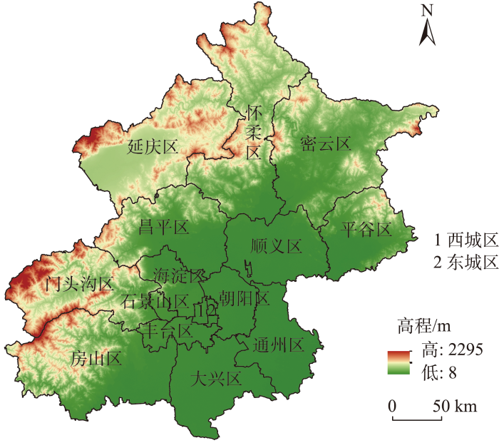
北京作为首都,是中国的政治中心、文化中心、国际交往中心、科技创新中心,共管辖16个市辖区。北京地处华北平原北部,位于115.4°~117.4°E、39.4°~41.1°N,地势西北高、东南低,西部、北部和东南部三面环山(图1),平均海拔43.5 m。其中,山区面积约占总面积的62%,是首都天然的生态屏障。
图1
2020、2021年的《北京市生态环境状况公报》表明,北京市全区大气环境、水环境、土壤环境、生态环境等状况持续向好,为森林康养旅游的发展提供保障。百万亩造林计划与加速推进“国家森林城市”创建活动为森林康养旅游提供场所,2021年北京市完成造林绿化约107 km2,全市森林覆盖率达44.6%。《北京城市总体规划(2016年—2035年)》提出2025年全市森林覆盖率达到45%。
2 材料与方法
2.1 数据来源
2.2 研究方法
2.2.1 评价指标
2.2.2 评价指标体系构建
表1 北京市森林康养旅游空间适宜性评价指标及权重
Tab.1
| 目标层 | 一级指标 | 一级指标权重 | 二级指标 | 二级指标权重 | 三级指标 | 三级指标权重 |
|---|---|---|---|---|---|---|
| 森林康养旅游空间适宜性 | 舒适度 | 0.5734 | 土地利用类型与游憩活动匹配度 | 0.0459 | 土地利用类型 | 0.0459 |
| 负氧离子 | 0.1301 | 负氧离子浓度 | 0.1301 | |||
| 地形适宜性 | 0.0649 | 海拔 | 0.0217 | |||
| 坡度 | 0.0223 | |||||
| 起伏度 | 0.0209 | |||||
| 植被质量 | 0.2280 | 标准化植被指数NDVI | 0.1265 | |||
| 净初级生产力NPP | 0.1015 | |||||
| 水文状况 | 0.0738 | 与水域的距离 | 0.0738 | |||
| 可借景观 | 0.0307 | 与周边A级以上景区的距离 | 0.0307 | |||
| 生态敏感性 | 0.1991 | 土壤侵蚀敏感性 | 0.1991 | 容许土壤流失量 | 0.1991 | |
| 开发条件 | 0.2275 | 可达性 | 0.1139 | 与道路的距离 | 0.1139 | |
| 基础设施完善程度 | 0.1136 | 与建成区的距离 | 0.1136 |
2.2.3 评价指标分级量化方法
参考国家、行业或地方标准和已有文献的分类标准,结合背景值标准,对每个评价指标进行分级量化和赋值。对于背景值标准的等级划分,采用ArcGIS 10.6中的自然断裂法,对研究区域背景数据指标得分进行分级。各指标分级标准及划分如表2所示。
表2 各指标评价标准及分级
Tab.2
| 指标 | 评价得分 | ||||
|---|---|---|---|---|---|
| 5 | 4 | 3 | 2 | 1 | |
| 土地利用类型 | 森林 | 灌木丛 | 湿地 | 草地 | 农田、非渗透表面、荒地、水域 |
| 负氧离子浓度/(个·cm-3) | >1500 | — | 1000~1500 | — | <1000 |
| 海拔/m | 100~400 | — | <100或400~1500 | — | >1500 |
| 坡度/(°) | <3 | 3~8 | 9~15 | 16~25 | >25 |
| 起伏度 | 0~0.50 | 0.51~1.00 | 1.01~1.50 | 1.51~2.00 | >2.00 |
| 标准化植被指数NDVI | 0.65~0.78 | 0.51~0.64 | 0.42~0.50 | 0.35~0.41 | -1~0.34 |
| 净初级生产力NPP/(g·m-2) | 401~440 | 301~400 | 201~300 | 101~200 | 0~100 |
| 与水域的距离/m | 0~500 | 501~1000 | 1001~2000 | 2001~3000 | >3000 |
| 与周边A级以上景区的距离/km | <1.0 | 1.0~5.0 | 5.1~10.0 | 10.1~15.0 | >15.0 |
| 土壤侵蚀敏感性/(t·km-2·a-1) | 251~350 | 201~250 | 151~200 | 101~150 | 50~100 |
| 与道路的距离/m | 0~500 | 501~1000 | 1001~2000 | 2001~3000 | >3000 |
| 与建成区的距离/km | <1.0 | 1.0~1.5 | 1.6~3.0 | 3.1~5.0 | >5.0 |
(1) 舒适度
人们进行森林康养的目的是放松身心、追求健康快乐,提升生活质量,为了满足游客需求,舒适度是首要考虑的问题。不同的土地利用类型和地形适宜性对游憩活动的支持能力不同[25];游客置身于高负氧离子浓度的环境中,可带来身体层面的舒适感,有益于健康;植被质量、水文状况、可借景观为游客带来美好的视觉感官,给予心理层面的舒适感。本文采用土地利用类型与游憩活动匹配度、负氧离子、地形适宜性、植被质量、水文状况及可借景观6个指标评测舒适度。
地形适宜性:地形条件是一个区域人类活动与社会经济发展的基础,地形的起伏对森林康养旅游的发展产生显著影响,是生态旅游基础设施建设的限制因子之一,包括海拔、坡度及起伏度。基于北京市浅山区规划以及Li等[30]的研究,当海拔为400 m时,负氧离子浓度达到最高,考虑在高海拔地区开发难度较大等原因不利于森林康养基地的建设,将海拔划分为100~400、<100或400~1500、>1500 m共3个等级;按照国际地理学联合会提出的坡度分类法,将坡度划分为<3°、3°~8°、9°~15°、16°~25°、 >25°共5个等级;起伏度是指地表一定范围内最大的相对高程差,它可以在一定程度上体现该地区地表高低起伏的状况,本文利用ArcGIS软件采用如下公式计算北京的地形起伏度[38-39],并将其分成5类,分别为0~0.50、0.51~1.00、1.01~1.50、1.51~2.00、>2.00。
式中:RDLS为地形起伏度,ALT为以某一栅格单元为中心一定区域内的平均海拔;H为海拔,Max(H)和Min(H)分别为区域内的最高与最低海拔;A为区域总面积;P(A)为区域内的平地面积。
植被质量:包括标准化植被指数NDVI和净初级生产力NPP。采用NDVI来测度地表植被的覆盖程度,极低值或负值表示完全无植被(如云、水或雪)区域,较低值表示仅有少量植被(如混凝土、岩石或裸土)的区域,中等值表示灌木丛和草地,较高值表示森林地区和茂盛的地表植被。根据相关研究[25,40],将植被覆盖度划分为0.65~0.78、0.51~0.64、0.42~0.50、0.35~0.41、-1~0.34共5个等级。NPP是生产者能用于生长、发育和繁殖的能量值,直接反映了植被群落在自然环境条件下的生产能力,表征陆地生态系统的质量状况,划分为401~440、301~400、201~300、101~200、0~100 g·m-2共5个等级[41]。
水文状况:水域是许多游憩活动必不可少的因素,不仅增加景观美景度,而且提升游憩活动多样性。根据李俊英等[42]研究将与水域距离划分成0~500、501~1000、1001~2000、2001~3000、>3000 m共5个等级。
可借景观:距离周边景区距离越近,游客来源越丰富,越能提升景观美景度和游憩活动多样性,将与周边A级以上景区的距离划分为<1.0、1.0~5.0、5.1~10.0、10.1~15.0、>15.0 km共5个等级。
(2) 生态敏感性
北京西部山地属于北方土石山区,其生态退化问题以水土流失较为严重,同时考虑数据可获得性及与森林康养旅游的关联性,用土壤侵蚀敏感性表征生态敏感性。容许土壤流失量是评价区域水土流失和生态环境状况的基础依据,本文选取容许土壤流失量作为土壤侵蚀敏感性指标。依据王志刚等[32]的研究,将容许土壤流失量由多到少依次划分为以下5个等级:251~350、201~250、151~200、101~150、50~100 t·km-2·a-1。
(3) 开发条件
森林康养旅游离不开发达的道路网络与水电网等基础设施,与道路的距离代表可达性,表征交通出行的难易程度和便利程度,与建成区(主要居民点)的距离表征森林康养旅游配套设施的完善程度,主要考虑建成区的医疗设施[36]。利用ArcGIS分别计算与道路、建成区的欧式距离,并根据相应标准划分等级。
2.2.4 综合评价模型
对上述指标层因子进行数据标准化后,在ArcGIS软件中综合各标准的分级结果及各因子的权重逐级归并集成,得出空间适宜性的评价结果,计算公式为:
式中:En为指标n的适宜性分值;p为指标n包含的下一层级指标数;Wi为指标i的权重;Ei为指标i的适宜性标准值。
在ArcGIS 10.6软件中,运用欧氏距离、坡度、重分类等空间分析方法,按照各指标的权重叠加分析,再运用自然断裂法进行分级,将分数由低到高依次划分为0~2.4532、2.4533~2.8221、2.8222~3.1215、3.1216~5共4个等级,分别对应康养旅游的适宜性Ⅰ级、II级、III级、IV级,以森林图层为掩膜,得到北京市森林康养旅游空间适宜性分布图。
3 结果分析
3.1 森林康养旅游空间适宜性总体评价及验证
从北京市森林康养旅游空间适宜性分布图可知(图2),适宜性最低等级Ⅰ级区域面积最小,为633 km2,仅占北京总面积的3.86%;II级、III级区域面积较大,分别为2919、2936 km2,占北京总面积的17.79%、17.89%;适宜性最高等级Ⅳ级区域面积为1102 km2,占北京总面积的6.72%。适宜发展森林康养旅游的III级、Ⅳ级区域面积占北京总面积的近25%,表明北京市森林康养旅游适宜性总体较高,森林康养旅游发展空间广阔。从空间适宜性的数量分布特征来看,各适宜度面积呈橄榄型分布,体现了保护性开发的理念,有利于森林康养旅游的可持续发展,最大程度地发挥森林的综合效益。从适宜性的空间分布特征来看,山区森林资源丰富,为森林康养旅游提供优良场所,III级、IV级区域主要集聚在西北部山区,西南山区III级、IV级区域较分散,I级、II级区域面积占据大部分;平原地区的森林康养适宜区域呈点状分布,森林资源不够丰富,但交通便利,设施服务相对完善。
图2
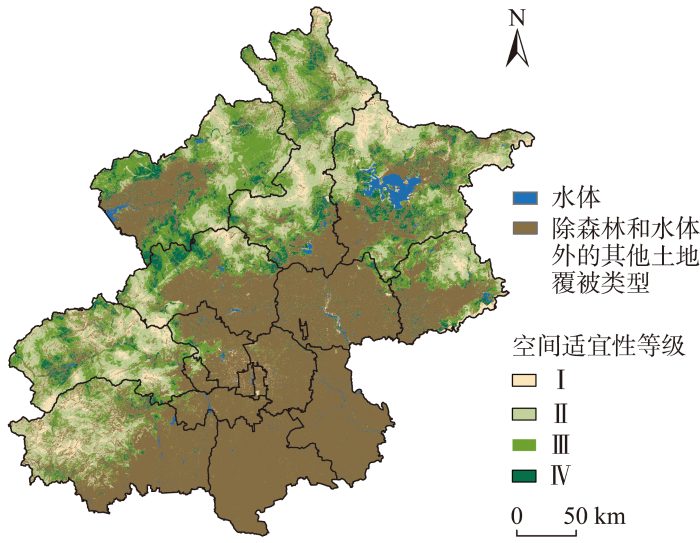
图2
森林康养旅游空间适宜性等级分布
Fig.2
Distribution of the spatial suitability grade of forest therapy tourism
北京自2012年开始发展森林疗养,截至2023年6月底,共有7家国家级森林康养基地试点/单位,以及国内首个符合本土认证标准并落地的北京八达岭国家森林公园的森林疗养基地等,主要设立在自然保护区、国家级森林公园中[22]。
图3

图3
验证点的森林康养旅游空间适宜性等级
Fig.3
Spatial suitability grade of forest therapy tourism of the verification points
3.2 自然分区尺度的空间适宜性分析
《北京城市总体规划(2016—2035年)》提出将浅山区建设成为首都生态文明示范区。浅山区作为平原与深山的过渡地带,生态资源与人文资源丰富,但城乡的快速发展导致浅山区存在生态破坏、环境污染等问题。为实现浅山区的高质量发展,《北京浅山区规划保护规划(2017—2035年)》(下文简称《规划》)明确,要用好生态与景观优势,发展高水平的生态型、人文型旅游服务,森林康养旅游是浅山区发展旅游的主要方向。《规划》规定了浅山区保护规划范围,以高程100~300 m的浅山本体为基础,占市域面积近30%,本文以100 m、300 m等高线为界,将研究区划分为平原区、浅山区和深山区3类,从自然分区尺度分析森林康养旅游适宜性空间格局,提出发展策略。
图4
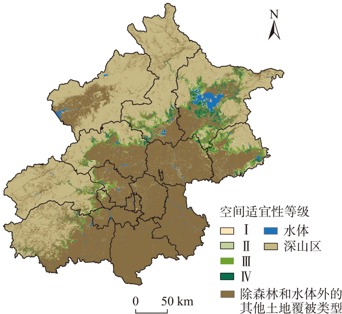
图4
浅山区森林康养旅游空间适宜性等级
Fig.4
Spatial suitability grade of forest therapy tourism in the shallow mountain areas
图5
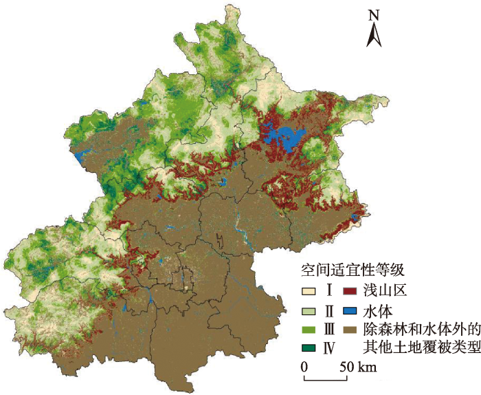
图5
深山区森林康养旅游空间适宜性等级
Fig.5
Spatial suitability grade of forest therapy tourism in the deep mountain areas
就山区看,III级、IV级区域主要分布在深山区,深山区的III级、IV级区域面积占山区III级、IV级区域面积和的75%。其中,最适宜森林康养的区域(IV级)31%分布在浅山区、57%分布在深山区;较适宜森林康养的区域(III级)21%在浅山区、76%在深山区。
平原地区森林资源较少且多为人造林,不适宜发展森林康养,可满足周边居民日常休闲需求,打造森林宜居城市;浅山区非常适宜发展森林康养旅游等绿色产业,可提供森林步道、森林课程、森林瑜伽、森林冥想等一日游、短途游标准化产品,室内与户外活动结合;深山区以森林体验为主,可提供定制化产品,满足游客的个性化需求,值得注意的是,虽然深山区森林面积广阔,但由于地形、可达性等限制因素,最不适宜发展森林康养的区域(I级)90%分布在深山区。
3.3 行政区尺度的空间适宜性分析
自然分区尺度的研究结果展示了北京总体的森林康养旅游空间适宜性水平,北京市各区的自然资源与人文资源禀赋不同,从行政区尺度进一步分析森林康养旅游适宜性,有利于为各行政区制定相应发展策略提供参考。北京市各行政区适宜性等级分布不均衡、差异较大,从空间上看,适宜性等级整体呈现从西北向东南逐渐降低的趋势。依据III级、IV级区域面积之和(图6),将16个市辖区分为4类,即优先发展区(III级和IV级区域面积超过700 km2)、次优发展区(III级和IV级区域面积处于201~700 km2)、择优发展区(III级和IV级区域面积处于20~200 km2)和有限发展区(III级和IV级区域面积低于20 km2)。
图6
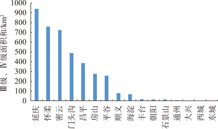
图6
各行政区III级、IV级适宜区域面积
Fig.6
Total area of suitability classes III and IV of each administrative district
(1) 优先发展区。延庆区、怀柔区、密云区III级、IV级适宜区面积广阔,超过700 km2,且分布较为集中。其中,延庆区森林康养旅游适宜性最高,III级、IV级区域面积占比70%,怀柔区、密云区占比均约50%,且三区的Ⅰ级区域面积占比皆低于10%(图7)。延庆与昌平交界处出现了森林康养旅游高适宜的聚集区域,大致可分为西部、中部、东部3个区域,其中西部是八达岭古长城自然风景区、石碴村、浇花峪村以及槟榔峪村、桃峪沟村等周边区域形成的高适宜聚集区域,中部是关果峪村、西古村、白查村、九仙庙村及大梁湾村及其周边区域形成的高适宜聚集区,东部是西三岔村、姑娘台村、黄花峪村、北沟村及其周边区域形成的高适宜聚集区。这3个高适宜聚集区域不仅拥有良好的自然生态环境基础,相较于怀柔和密云,交通也更加便利,可形成齐头并进的发展格局。怀柔区自然资源丰富,可结合百年民俗“敛巧饭”和浓郁的满族文化,以民俗风情、少数民族文化为特色,打造森林康养旅游。密云区的密云水库周边也形成森林康养旅游高适宜等级聚集区域,利用密云水库打造独特的水文森林环境,规划多样化的康养路线和产品。三区的森林资源禀赋极为优质,可突出空气质量要素的吸引力,以及芬多精、负氧离子、自然景观等对人体的康养作用,以多日康养为主,提供饮食、住宿、娱乐休闲等项目,并在专业人员的带领下进行森林浴等保健活动。
图7
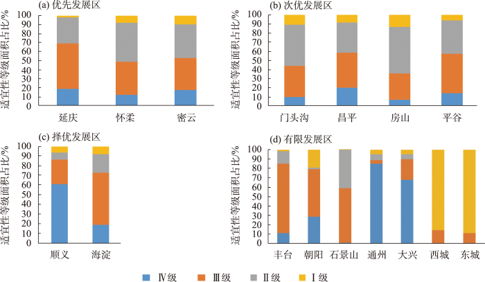
图7
各发展区适宜性等级面积占比
Fig.7
Areal proportion of each suitability class in the development zones
(2) 次优发展区。门头沟区、昌平区、平谷区、房山区III级、IV级区域面积处于201~700 km2间。其中,平谷区和房山区III级、IV级区域面积相当,但房山区III级、IV级区域面积占比仅35%,比平谷区低20%(图7)。门头沟与房山区相邻,门头沟区文物资源、传统村落、非物质文化遗产与房山区的古人类活动遗址、京绣可结合发展,以历史文化为特色开展森林康养旅游。昌平区北部以蟒山国家森林公园为核心,西部与延庆区联合发展自然景观与人文结合的森林康养旅游。平谷区三面环山,是北京重要的农副产品基地,可以果园、农田采摘为特色发展森林康养旅游。
《北京城市总体规划(2016年—2035年)》提出门头沟、平谷、怀柔、密云、延庆5个区,以及昌平和房山的山区是生态涵养区,是首都重要的生态屏障、水源保护地和“大氧吧”,是保障首都可持续发展的关键区域。森林康养旅游既符合北京市空间结构定位,又促进其功能定位的实现,各区可结合自身优势与特色发展森林康养旅游,提供差异化产品和服务。
(3) 择优发展区。顺义区、海淀区适宜发展森林康养旅游的面积相当,且两区的III级、IV级区域面积占比高于70%(图7)。但与延庆、怀柔相比,适宜发展的面积太小,同时顺义区III级、IV级区域分布极为分散。在海淀区的西部山区出现了集中分布的高等级适宜区,资源禀赋好、交通条件便利,该地区可作为海淀区发展森林康养旅游的首选区域。以鹫峰国家森林公园、香山公园、阳台山风景名胜区等作为森林康养基地建设主体,以科技、教育为基地赋能,发挥森林的科普宣教功能,开展以青少年为主的短途一日森林康养旅游。
(4) 有限发展区。丰台区、朝阳区、石景山区、大兴区、通州区位于北京市平原地区,平原地区森林覆盖率相对较低,且多为人造林,森林康养旅游空间有限,虽III级、IV级适宜区域占比高(图7),但面积极小、呈点状分布,并不适宜开展大规模森林康养旅游。作为首都功能核心区的东城区、西城区,是全国政治中心、文化中心和国际交往中心的核心承载区,历史文物古迹类旅游资源在此区域聚集,是北京A级旅游景区最密集的地区,但不适宜开展森林康养旅游,适宜等级主要为Ⅰ级、Ⅱ级。
3.4 森林康养旅游发展策略
北京是重要的旅游目的地和客源地,A级景区超过200家,吸引了大量国内外游客。目前森林康养优先发展区延庆区、怀柔区、密云区A级景区数量分别是12、18、21家,以自然观光类景区为主,依托自然资源开展旅游活动。将A级景区与森林康养旅游适宜区域分布进行叠加分析可知,延庆区、怀柔区和密云区分别有8(67%)、11(61%)和13(62%)家景区位于III级、IV级区域内(图8)。
图8
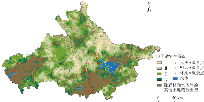
图8
延庆、怀柔和密云三区A级景点空间分布
Fig.8
Spatial distribution of A-class tourist attractions in Yanqing, Huairou and Miyun districts
三区可依托现有的A级景区形成各区的森林康养旅游发展格局,打造特色化、差异化产品。延庆区可探索“乡村民宿+冬季滑雪+长城文化”的特色发展模式。北部以百里山水画廊为核心,以周边特色民宿为特色,打造夏季避暑森林康养旅游产品;西部以石京龙滑雪场为核心,打造冬季滑雪及室内森林课程,如森林冥想、森林瑜伽,在森林环拥的冰天雪地中感受身心的平静与大地的寂静;南部以八达岭古长城、八达岭水关长城为核心,打造春秋两季的赏花、赏叶与长城文化结合的森林康养产品,形成“环境教育+体验活动”的森林文化推广模式。自2016年以来,延庆区八达岭国家森林公园的森林公园体验馆,针对更年期女性、高压力人群、高血压人群、大学生、残障人士、自然教育机构和森林疗养师专业人士等不同群体已开展不同主题不同时长的森林体验活动,如徒步观赏红叶、看汉服表演、正念午餐、正念冥想、品草本茶、手工制作等。
怀柔区的森林覆盖率达到77.3%,其森林资源位居全市首位,可打造“生活在森林中:绿色养生膳食+山居小镇+森林氧吧”的深度体验与“标准森林产品”结合的特色发展模式。北部以喇嘛沟原始森林公园为核心,打造夏日森林康养度假产品,由于其地理位置限制,距市区较远,可针对中老年人开展多日森林体验产品,在森林边缘建设养老社区,打造京郊养老小镇;南部景区丰富,以九谷口自然风景区、神堂峪、雁栖湖为核心,联合打造森林步道,提供初级森林服务。
密云区可围绕密云水库打造“亲子游+山地温泉”的发展模式。密云水库西北部是景区密集分布区,夏日以桃源仙谷、黑龙潭、清凉谷等景区为核心开展森林康养旅游;密云区北部的云峰山童话树屋针对儿童在森林中开展“森林工坊”,面向亲子家庭开展各种森林体验活动,如种子的秘密(寻找多种多样的植物的种子)、秋日寻叶(一起认识和收集各种叶子)、森林放映(在禅意浓浓的东禅院,和家人一起看场电影)、植物扎染(采用植物的色彩,把一块白色的布染上颜色)等,让儿童与自然互动,在体验中认识自然;冬日以密云水库南部以北京海湾半山温泉酒店为重心,12个户外天然温泉泡池与山林相连,打造森林温泉;2022年初步提出的北京森林步道的建设方案,目前5条森林步道已完成,其中五座楼林场森林步道全长10 km,是一条纵览密云水库的步道。
在疫情常态化背景下,周边游、开放性户外游成为旅游发展新热潮,国民对自然环境具有生理心理双层需求,以健康为核心的森林康养旅游迎来发展新契机。将森林康养与本土优势结合,开展以民俗文化、民族特色、有机产品、体育、露营等主题的森林康养旅游,森林康养作为一种新兴业态产业,借势森林旅游助力美丽乡村建设,可实现乡村生态振兴[47]。
4 结论与讨论
本文针对北京市森林康养发展现状,建立了包含舒适度、生态敏感性和开发条件3个一级指标和9个二级指标的评价指标体系,利用AHP确定各指标权重,依托空间大数据和GIS分析工具,绘制了北京市森林区域森林康养旅游适宜性的空间分布图。主要结论如下:
(1) 森林康养旅游作为一种新型旅游理念与旅游方式,依托森林相关资源,包括周边可游憩的景观资源以及环境的舒适度,以可持续发展的理念为旅游者提供相应的服务。因此,本文从舒适度、生态敏感性和开发条件3个维度构建了森林康养旅游空间适宜性评价指标体系。一级指标中,舒适度的重要性权重最高,其次是开发条件,生态敏感性的重要度最低;二级评价指标中,重要性权重最高的是植被质量。国内外大量研究证明,暴露在森林环境中对身心健康有积极的影响,森林中大量的负氧离子及芬多精对多种疾病有治疗作用[3⇓⇓⇓⇓⇓-9],优良的森林资源是森林康养旅游的首要条件。虽然舒适度指标的权重高于生态敏感性,但在精品民宿、森林康养、生态旅游等适宜产业的发展过程中,需重视生态保护,尤其是在生态涵养区,生态保护红线区域是需要严格保护的,必须对产业发展进行科学规划和管理。森林康养与旅游的结合必须把森林健康放在首位,健康美丽森林是康养旅游的底色、亮色,人类健康与森林健康有机统一才能实现可持续发展。
(2) 北京市森林康养旅游空间适宜性等级由低到高分为4个等级,其中III级和IV级区域面积分别为2936、1102 km2,占4个适宜性区域总面积的53%,主要集聚在北京的西北部山区。北京市森林康养旅游适宜性总体较高,发展空间广阔。
(3) 从自然分区尺度分析,浅山区非常适宜开展森林康养旅游,III级、IV级区域面积占浅山区全部适宜面积的77%,但总体面积较小。深山区Ⅱ级、III级区域面积较大且相当,占深山区全部适宜面积的80%,Ⅰ级、IV级区域面积相当且较小。就山区整体分析,III级、IV级区域主要分布在深山区,深山区的III级、IV级区域面积占山区III级、IV级区域总面积的75%,但由于可达性等限制,最不适宜发展森林康养的区域(I级)90%也分布在深山区。平原地区为居民提供日常森林游憩空间,浅山区以标准化森林产品为主,深山区满足游客的个性化需求。
(4) 从行政区尺度分析,各行政区森林康养旅游空间适宜性等级分布不均衡,空间上呈现从西北向东南适宜性等级逐渐降低的趋势,将北京市16个市辖区分为4类,即优先发展区(延庆区、怀柔区、密云区)、次优发展区(门头沟区、昌平区、平谷区、房山区)、择优发展区(顺义区、海淀区)和有限发展区(丰台区、朝阳区、石景山区、大兴区、通州区、东城区、西城区)。
(5) 在发展策略上,延庆区探索“乡村民宿+冬季滑雪+长城文化”的特色发展模式;怀柔区打造“生活在森林中:绿色养生膳食+山居小镇+森林氧吧”深度体验与“标准森林产品”结合的特色发展模式;密云区围绕密云水库打造“亲子游+山地温泉”的发展模式。各区充分整合森林康养资源,与现有知名成熟旅游景点联动,挖掘北京森林康养旅游发展潜力;同时,森林康养为自然风景区的发展提供新思路,以森林康养作为旅游恢复新路径,也为周边乡村旅游发展提供新思路[48]。
森林康养旅游作为实现“绿水青山就是金山银山”理念的重要产业形式,将自然资源转化为生态产品,是近年来学者们的关注热点。在评价指标系方面的研究,已有学者从不同角度切入,但较多停留在构建层面,并未对指标的可行性做进一步的实践验证,本文在指标构建后,以北京市为案例区对其进行应用验证。本文从游憩适宜性角度出发,构建森林康养旅游空间适宜性评价指标,综合运用自然科学、管理科学理论和方法,对北京地区森林康养旅游适宜性进行定量评价,并对其发展空间格局进行可视化分析,并提出了延庆区、密云区、怀柔区的森林康养旅游发展模式。由于缺少北京市各地区实测的负氧离子浓度数据,本文以已有文献中的负氧离子浓度数据为基础,采用克里格插值法估算北京市全域负氧离子浓度,可能存在一定偏差,今后需与监测结果相结合进行进一步研究。此外,疫情影响了大规模的实地调研,后续研究应更多侧重于实地调研,使森林康养旅游评价指标更科学合理,挖掘北京森林康养旅游发展潜力,为周边乡村旅游提供新思路。该指标体系对北京以外地区的森林康养旅游发展具有一定的借鉴性。
参考文献
Current development status of forest therapy in China
[J].As a result of rapid urbanization and urban sprawl, natural ecosystems are shrinking or are fragmented, affecting people’s health and quality of life. Modern people prefer to live in large cities rather than rural areas because of greater convenience and more comfortable living conditions. As a consequence, people are suffering from many psycho-physiological health problems and have a longing for natural environments to escape the concrete jungle. Forest therapy has emerged as a preventive and alternative therapy to cope with stress and enhance people’s health and wellbeing as a result of spending time in a green and healthy environment. Here, we review the activities related to forest therapy in China and discuss the commonalities and differences between the forest therapy types. Furthermore, we summarize the current achievements of forest therapy in basic research and the development of the forest therapy industry. We also describe the challenges that forest therapy has been facing. Finally, we provide suggestions for further development in research and industry.
Trends in research related to "shinrin-yoku" (taking in the forest atmosphere or forest bathing) in Japan
[J].
DOI:10.1007/s12199-009-0091-z
PMID:19585091
[本文引用: 1]

"Shinrin-yoku", which can be defined as "taking in the forest atmosphere or forest bathing", has been receiving increasing attention in Japan in recent years for its capacity to provide relaxation and reduce stress. Since 2004, the authors of this paper have been involved in an investigation designed to ascertain the physiological effects of "Shinrin-yoku" within the framework of the "Therapeutic Effects of Forests" project. We have conducted physiological experiments, both in actual forests and in the laboratory, to elucidate the physiological effects on individuals of exposure to the total environment of forests or to only certain elements of this environment, such as the odor of wood, the sound of running stream water, and the scenery of the forest. We have obtained physiological measurements of central nervous activity, autonomic nervous activity, and biomarkers reflecting stress response that can be applied in this line of approach. Using these measurements, we have summarized the separate elements of forests in terms of the five senses. We have also reviewed a selection of field studies and introduced a number of results from ongoing projects as well as those from early studies. Future perspectives are also discussed.
The effects of forest therapy on immune function
[J].We conducted a systematic review of the effects of a forest therapy program on adults’ immune function. We used PICO-SD (participants, interventions, comparisons, outcomes, study design) to identify key items. The participants were adults over the age of 18 and the intervention was forest therapy. Our comparisons included studies that comparatively analyzed urban groups or groups that did not participate in forest therapy intervention. Cases without control groups were also included. Immunological outcome measures were included in measuring intervention outcomes. All experimental studies, such as randomized controlled trials (RCTs), non-equivalent control group designs (non-RCTs), and one-group pretest-posttest design were included in the study design. A total of 13 studies were included for comparison. Forest therapy programs were divided into lodging-type and session-type programs. The representative measures for evaluating the effects of immune function were the number of NK cells, the cytotoxic activity of NK cells, and cytotoxic effector molecules. Most studies reported improvement in these measures when comparing values after intervention with values before the forest therapy intervention. Therefore, forest therapy has been found to be effective in improving immune function. More RCT studies on the effects of forest therapy on immune function are necessary.
Forest bathing always makes sense: Blood pressure-lowering and immune system-balancing effects in late spring and winter in central Europe
[J].Various formats of forest bathing have been receiving increasing attention owing to their perspectives in health promotion and the treatment of chronic lifestyle diseases. The majority of field studies are still being conducted in the Far Eastern region, and they often make psychological assessments mainly in the green season. In our pretest–posttest field experiment, twelve healthy, working-age volunteers participated in a 2-h leisurely forest walking program, first in the green season (May) and then in the winter season (January), in the Mecsek Hills, next to Pécs, Hungary. Systolic blood pressure decreased after the trips both in late spring and in the winter. Based on changes in the expressions of CD69, an early activation marker, NKG2D, a major recognition receptor, perforin, granzyme B, and TIM-3, an inhibitory immune checkpoint molecule, on CD8+ cytotoxic T, NK, NKdim, NKbright, and NKT cells, we detected the stimulation of NKbright cells and activation of all examined immune cell subsets in the green season. In the winter, a slight activating and an interesting balancing effect regarding TIM-3 could be observed considering our finding that basal (pretest) TIM-3 expression by NK cells was significantly lower in the winter. Our work expands the knowledge on and potentials of forest medicine.
Physiological effects of nature therapy: A review of the research in Japan
[J].
Effects of forest bathing on pre-hypertensive and hypertensive adults: A review of the literature
[J].The aim in this literature review was (1) to explore the physiologically and psychologically therapeutic benefits of forest bathing on adults suffering from pre-hypertension or hypertension, and (2) to identify the type, duration, and frequency of an effective forest bathing intervention in the management of pre-hypertension and hypertension, so as to provide directions for future interventions or research. The electronic databases PubMed, Cochrane Library, CINAHL, PsyINFO, and the China Academic Journals (CAJ) offered through the Full-text Database (CNKI) were searched for relevant studies published from the inception of the databases to April 2019. Of the 364 articles that were identified, 14 met the criteria for inclusion in this review. The synthesis of the findings in the included studies revealed that forest bathing interventions were effective at reducing blood pressure, lowering pulse rate, increasing the power of heart rate variability (HRV), improving cardiac-pulmonary parameters, and metabolic function, inducing a positive mood, reducing anxiety levels, and improving the quality of life of pre-hypertensive or hypertensive participants. Forest walking and forest therapy programs were the two most effective forest bathing interventions. Studies reported that practicing a single forest walking or forest therapy program can produce short-term physiological and psychological benefits. It is concluded that forest bathing, particularly forest walking and therapy, has physiologically and psychologically relaxing effects on middle-aged and elderly people with pre-hypertension and hypertension.
Effects of forest bathing (shinrin-yoku) on levels of cortisol as a stress biomarker: A systematic review and meta-analysis
[J].
DOI:10.1007/s00484-019-01717-x
PMID:31001682
[本文引用: 2]
Forest bathing is a traditional practice characterized by visiting a forest and breathing its air. This review aims to investigate the effects of forest bathing on levels of salivary or serum cortisol as a stress biomarker in order to understand whether forest bathing can reduce stress. Medline/PubMed, Embase, Scopus, Web of Science, Cochrane Library, and Google Scholar were systematically searched for relevant articles. The quality of included trials was assessed following the criteria of the NIH dedicated tools. Afterwards, a qualitative and quantitative synthesis of retrieved evidence was performed. A total of 971 articles were screened; 22 of them were included in the systematic review and 8 in the meta-analysis. In all but two included studies, cortisol levels were significantly lower after intervention in forest groups if compared with control/comparison groups, or a significant pre-post reduction of cortisol levels was reported in the forest groups. The main results of the meta-analysis showed that salivary cortisol levels were significantly lower in the forest groups compared with the urban groups both before (MD = - 0.08 μg/dl [95% CI - 0.11 to - 0.05 μg/dl]; p < 0.01; I = 46%) and after intervention (MD = - 0.05 μg/dl [95% CI - 0.06 to - 0.04 μg/dl]; p < 0.01; I = 88%). Overall, forest bathing can significantly influence cortisol levels on a short term in such a way as to reduce stress, and anticipated placebo effects can play an important role in it. Further research is advised because of the limited available data.
A comparative study of the physiological and psychological effects of forest bathing (shinrin-yoku) on working age people with and without depressive tendencies
[J].
Forest therapy can prevent and treat depression: Evidence from meta-analyses
[J].
Effect of forest bathing on physiological and psychological responses in young Japanese male subjects
[J].
DOI:10.1016/j.puhe.2010.09.005
PMID:21288543
[本文引用: 1]
To provide scientific evidence supporting the efficacy of forest bathing as a natural therapy by investigating its physiological benefits using biological indicators in outdoor settings.Within-group comparisons were used to examine psychological and physiological responses to exposure to real forest and urban environments.Young Japanese male adults participated in a 3-day, 2-night field experiment. Physiological responses as well as self-reported psychological responses to forest and urban environmental stimuli were measured in real settings. The results of each indicator were compared against each environmental stimulus.Heart rate variability analysis indicated that the forest environment significantly increased parasympathetic nervous activity and significantly suppressed sympathetic activity of participants compared with the urban environment. Salivary cortisol level and pulse rate decreased markedly in the forest setting compared with the urban setting. In psychological tests, forest bathing significantly increased scores of positive feelings and significantly decreased scores of negative feelings after stimuli compared with the urban stimuli.Physiological data from this field experiment provide important scientific evidence on the health benefits of forest bathing. The results support the concept that forest bathing has positive effects on physical and mental health, indicating that it can be effective for health promotion. Despite the small sample size in this study, a very clear tendency towards positive physiological and psychological outcomes in forests was observed.Copyright © 2010 The Royal Society for Public Health. Published by Elsevier Ltd. All rights reserved.
Effect of forest therapy for menopausal women with Insomnia
[J].
DOI:10.3390/ijerph17186548
URL
[本文引用: 1]
Female hormone changes during menopause can affect the autonomic nervous system, circadian rhythm, and secretion of cortisol/melatonin, resulting in a vulnerability to insomnia. In this light, therapy has been gaining attention as a way to reduce stress hormones by stabilizing the autonomic nervous system. Thus, this study aims to objectively and scientifically analyze the impact of forest therapy in postmenopausal insomnia patients. The forest therapy program lasted 6 days, wherein 35 postmenopausal women performed activities such as trekking, leg massages, stretches, and bathing in warm and cold water. They also underwent serologic tests, participated in polysomnography (PSG), and answered sleep questionnaires before and after the program. Further, a statistical analysis compared the results. Serologic tests showed a significant reduction of cortisol from 10.2 ± 3.79 to 7.75 ± 2.81, while PSGs showed how sleep efficiency increased to 89.3 ± 4.3% (p < 0.01), and how waking after sleep onset reduced to 47.4 ± 22.3 min (p < 0.01). The total sleep time also increased to 428.5 min and sleep latency was 11.1 ± 11.0 min. Despite its limitations, forest therapy could be a good alternative to nonpharmacological treatment for mitigating insomnia in postmenopausal women.
Effect of forest therapy program on stress and physical health promotion of forest fire victims
[J].DOI:10.5322/JESI. URL [本文引用: 1]
The effect of forest therapy program on probationary Juveniles' attitudes toward forest and angry
[J].
森林康养消费者情绪状态对身心健康恢复的影响
[J].
Influence of the emotional state of forest therapy consumers on the recovery of physical and mental health
基于SAS的森林心理保健功能研究
[J].
A research on forest mental health function based on SAS
基于Hiscite和CNKI计量化分析的中外森林康养实证研究比较
[J].
Comparison of national and international empirical researches on forest therapy
森林康养产业发展研究综述
[J].
A summary of forest health and wellness tourism studies
森林康养基地建设适宜性评价指标体系研究
[J].
Study on the suitability evaluation index system of forest wellness base construction
森林康养旅游评价指标体系构建研究
[J].
Study on the construction of forest health tourism evaluation index system
北京和谐宜居之都建设中的森林文化服务提升
[J].
Forest culture services improvement in building a harmonious and livable Beijing City
森林康养基地建设探究
[J].
The exploration of forest wellness base construction
森林康养基地规划设计研究
[J].
Study on the planning and design of forest therapy base
旅游扶贫重点村空间可达性分布特征及影响因素研究
[J].
DOI:10.18306/dlkxjz.2019.12.004
[本文引用: 1]
在国家提出乡村振兴和旅游扶贫政策的大背景下,为了发挥旅游交通在区域发展中的带动作用,为旅游扶贫重点村建设和加快区域脱贫提供理论依据,文章以湖北武陵山区258个旅游扶贫重点村为研究样本,运用栅格成本加权距离算法与地理加权回归模型(GWR)对其旅游交通可达性及影响因素在空间上影响程度及作用方向的差异进行了探究。研究发现:湖北武陵山区内旅游扶贫重点村的平均可达时间为1.82 h,区域整体可达性相对较差,出行成本较高;从自然及人文2个视角对旅游扶贫重点村可达性的影响因子进行提取,各个影响因子在区域上作用大小的排序为:距最邻近县市最短路径>高程>周边旅游资源禀赋>距河流最短距离>距周边景区最短距离>坡度,距河流最短距离及周边旅游资源禀赋与可达成本呈负相关关系,其余因素均与可达成本呈正相关关系;距周边景区最短距离与坡度值大小的单位变化对可达成本空间差异的影响不显著。
Spatial accessibility distribution characteristics and influencing factors of the tourism poverty alleviation key villages in Wuling Mountain area, Hubei Province
DOI:10.18306/dlkxjz.2019.12.004
[本文引用: 1]
In the context of rural revitalization and poverty alleviation through tourism proposed by the state, in order to give play to the driving role of tourism transportation in regional development, it is important to provide a theoretical basis for the construction of key villages for poverty alleviation through tourism and the acceleration of regional poverty alleviation. Taking 258 tourism poverty alleviation key villages of in the Wuling Mountain area of Hubei Province as research samples, this study used the raster cost-weighted distance algorithm and the geographically weighted regression (GWR) model to explore the spatial differences in the accessibility of tourism transportation and the influence degree and direction of the influencing factors. The results show that: In the Wuling Mountain area, the average time to reach the tourism poverty alleviation key villages is 1.82 hours, the overall regional accessibility is relatively poor, and the travel cost is high. Factors affecting the accessibility of tourism poverty alleviation key villages in both the natural and social dimensions were extracted. The order of the impact of each influencing factor in the region is as follows: shortest path from the nearest county and city > elevation > tourism resource endowment in the surrounding area > shortest distance from a river > shortest distance from the surrounding scenic spot > slope. The shortest distance from a river and surrounding tourism resource endowment are negatively correlated with the cost of access, while other factors are positively correlated with the cost of access. The unit change of the shortest distance from the surrounding scenic spot and the slope value has relatively insignificant influence on the spatial difference of access cost.
气候变化背景下青海省三江源地区游憩功能格局演变
[J].
Spatial and temporal evolution of recreational function in the Sanjiangyuan region of Qinghai Province under climate change
国家公园研学旅行适宜性评价指标体系构建与实证研究
[J].
Construction and empirical analysis of the suitability evaluation of study travel development in national park
景观管理嵌入乡村旅游人地关系研究的应用框架建构
[J].
DOI:10.18306/dlkxjz.2022.03.013
[本文引用: 1]
在旅游话语中,景观是旅游行为与旅游地相互作用结果的客观呈现,链接着客观存在与主观感知、过去与未来、地方与全球,可以成为管理乡村旅游人地关系问题的有力工具。论文从阐释景观概念与景观管理体系出发,对乡村旅游景观管理的本质与脉络、景观管理在乡村旅游人地关系上的嵌入做了系统梳理,主要结论包括:① 乡村旅游地景观管理的价值逻辑包括人类中心主义与非人类中心主义的制衡、工具理性与价值理性的平衡,以及“景观”与“可持续发展”悖论的消解;② 乡村旅游地景观管理在人文地理学角度主要以地方、空间、景观的理论范式为体系,三者是从不同角度来阐释人地关系的辩证关系概念;③ 乡村旅游景观管理的技术路线包括景观规划和景观保护2个主要阶段,在定量研究方面可以使用景观生态学方法,在定性研究方面则可以借鉴景观符号学方法;④ 乡村旅游地景观管理的研究框架是以生态性问题为核心,以主体性问题、时间性问题、空间性问题为基底。
A framework for incorporating landscape management into the human-environment relationship research of rural tourism
DOI:10.18306/dlkxjz.2022.03.013
[本文引用: 1]
In tourism discourses, landscape is the objective manifestation of the interaction between tourism behavior and tourism destination. It links the objective existence and subjective perception, the past and future, and the local and global. It can be a powerful tool to manage the relationship between human and nature in rural tourism. Starting from the interpretation of the concept of landscape and landscape management system, this study systematically examined the essence and context of rural tourism landscape management and the incorporation of landscape management into the human-environment relationship research of rural tourism. The main conclusions include: 1) The ideological logic of rural tourism landscape management includes the balance between anthropocentrism and non-anthropocentrism, the balance between instrumental rationality and value rationality, and the resolution of the paradox between landscape and sustainable development. 2) From the perspective of human geography, rural tourism landscape management is mainly based on the place, space, and landscape theoretical paradigms. The three explain the concept of human-environment relationship from different angles. 3) The technical route of rural tourism landscape management includes two main stages: landscape planning and landscape protection. Landscape ecology methods can be used in quantitative research, and landscape semiotics methods can be used for reference in qualitative research. 4) The research framework of rural tourism landscape management takes ecological issues as the core, and subjectivity, temporal, and spatial issues as the bases.
Stable classification with limited sample: Transferring a 30-m resolution sample set collected in 2015 to mapping 10-m resolution global land cover in 2017
[J].DOI:10.1016/j.scib.2019.03.002 PMID:36659725 [本文引用: 2]
北京地区不同植被类型空气负离子浓度及其影响因素分析
[J].DOI:10.16258/j.cnki.1674-5906.2015.05.015 [本文引用: 1]
Variations in negative air ion concentrations associated with different vegetation types and influencing factors in Beijing
Distribution characteristics and law of negative air ions in typical garden flora areas of Beijing
[J].
Spatiotemporal differences in forest ecological security warning values in Beijing: Using an integrated evaluation index system and system dynamics model
[J].DOI:10.1016/j.ecolind.2019.05.015 URL [本文引用: 2]
北京市容许土壤流失量特征分析与空间分布图制作
[J].
Characteristics analysis and spatial distribution mapping of soil loss tolerances in Beijing
Mapping of recreation suitability in the Belgrad Forest Stands
[J].
A GIS-MCDM-based road network planning for tourism development and management in Arasbaran forest, Iran
[J].
Mapping forest landscape multifunctionality using multicriteria spatial analysis
[J].
功能约束条件下的钱江源国家公园体制试点区游憩利用适宜性评价研究
[J].
Assessment of recreational use suitability of Qianjiangyuan National Park Pilot under the zoning constraints
森林游憩区空气负离子评价研究
[J].
Research on evaluation of the aeroanion in forestry recreational areas
基于栅格的豫西山区地形起伏特征及其对人口和经济的影响
[J].
DOI:10.11821/dlxb201806008
[本文引用: 1]
地形起伏是约束山区人口分布和经济发展的关键因素,尤其在山地平原过渡带其约束作用更为显著。以位于秦岭—黄淮平原过渡带的豫西山区为例,基于200 m分辨率DEM数据,采用均值变点法确定地形起伏度的最佳统计单元,并提取地形起伏度;以1∶10万土地利用、乡镇人口和县域各产业数据为基础,建立人口和经济空间化模型,同时生成200 m分辨率的栅格人口和经济密度图;在系统分析地形起伏度、人口和经济密度空间分布规律的基础上,借助统计分析方法基于栅格单元定量揭示了地形起伏度对人口和经济的影响,并与其他地形因子的影响进行对比分析。结果表明:① 豫西山区地形起伏度以低值为主,58.6%的区域地形起伏度小于等于0.5个基准山体的高度(相对高差≤ 250 m);空间上呈西高东低、中间高南北低的格局,与海拔、坡度均呈较强的正相关,且与坡度的相关性更大。② 被选作验证的人口和经济数据与对应模拟值的线性拟合度分别为0.943和0.909,表明空间化结果能反映人口和经济分布的实际状况。③ 地形起伏度对人口和经济的影响强于其他地形因子的影响,与人口密度和经济密度呈较好的对数拟合关系,拟合度分别为0.911和0.874;豫西山区88.65%的人口居住在地形起伏度不超过0.5的地区,88.03%的生产总值分布在地形起伏度不超过0.3的地区。相对人口分布,研究区的经济发展向地形起伏度低值区的集聚态势更加明显。
Spatial variation of terrain relief and its impacts on population and economy based on raster data in west Henan mountain area
DOI:10.11821/dlxb201806008
[本文引用: 1]
<p>Topographic relief can be the constraining factor for the population and economic development in an area. This is especially the case in transitional zones from mountains to plains. In this study, West Henan Mountain Area, situated in the transitional zone from the Qinling Mountains to the Huang-Huai Plain (i.e. the second step to the third step of Chinese macro-topography), was selected as a case study area. Based on the optimal statistical unit (OSU) as determined by the mean turning-point analysis method (MTPAM), a DEM of 200 m resolution was used to extract the relief degree of land surface (RDLS). Integrating the 1:100, 000 land use map, statistical population data at township level and economic data of various industries at county level, raster models of spatial patterns of population and economy were formulated, and then the spatial distributions of population density and economic density at a resolution of 200 m by 200 m were produced using the models. Subsequently, statistical analysis was carried out to reveal the effects that RDLS had on population and economy based on raster data (i.e. RDLS, population density, and economic density), and the differences between the effects of RDLS and those of other terrain factors on the population and economy were also analyzed. The results showed that: (1) the RDLS in the West Henan Mountain Area was prevailed by low value, with 58.6% of the area having the RDLS lower than 0.5 (relative altitude of ≤ 250 m). Spatially, RDLS was higher in the west and lower in the east, higher in the central part and lower in the south and the north. Moreover, there existed strong positive correlations between RDLS and altitude and slope, especially correlated with slope significantly. (2) The relationships between the statistical values (i.e. population density and economic density which were selected to test and verify the models) and the corresponding simulated values were fitted to linear models with 0.943 and 0.909 levels of goodness-of-fit. This fitness indicated that the spatialization results reflected well the actual spatial patterns of population and economy in the study area. (3) The effect of RDLS on population and economy is stronger than that of other terrain factors. RDLS had a good logarithmic fit with population density and economic density, with 0.911 and 0.874 goodness-of-fit, respectively. Specifically, 88.65% of the total population lived in the areas where RDLS was less than 0.5 and 88.03% of the gross regional production was distributed in the areas where RDLS was less than 0.3. It can be clearly seen that economic development was more inclined to agglomerate in areas of lower RDLS values compared with population distribution.</p>
地形起伏特征对汉中市人口与经济的空间分布格局影响研究
[J].
Research on the influence of topographic relief on the spatial distribution pattern of population and economy in Hanzhong City
生态敏感区旅游开发适宜性评价及生态制图方法
[J].
Ecological suitability assessment and eco-mapping for tourism development in eco-sensitive region
基于CASA模型的北京植被NPP时空格局及其因子解释
[J].
NPP spatial and temporal pattern of vegetation in Beijing and its factor explanation based on CASA model
基于景观视觉敏感度的棋盘山生态旅游适宜性评价
[J].
Ecological suitability evaluation for eco-tourism in Qipanshan area based on landscape visual sensitivity
基于GIS的北京市水土流失生态风险评价
[J].
Ecological risk assessment of soil erosion in Beijing based on GIS
福建省康养旅游资源空间分布特征及其影响因素研究
[J].
The spatial distribution characteristics and influence factors of health and wellness tourism resources in Fujian Province
高级别景区对旅游发展的影响及其空间效应研究
[J].
DOI:10.18306/dlkxjz.2022.08.002
[本文引用: 1]
打造高品质旅游集聚地并构建多站点景区游览环线是推进全域旅游发展的重要突破口。论文基于2006—2018年288个城市评选的最高级别景区——“5A”景区的数据,将“5A”景区划分为自然类、人文类、综合类3类,借助ArcGIS、Stata等工具探索了“5A”景区的空间分布特征,并利用动态空间面板模型定量探讨了高级别景区对城市旅游发展的影响及其空间效应。研究发现,首先,中国“5A”景区存在“东中集聚、区域失衡、禀赋不一”的空间分布特征,综合类景区数量严重不足。其次,高级别景区能显著推动本城市的旅游发展,并存在显著的空间合作与空间竞争效应。其中,同省邻近城市的高级别景区对城市旅游发展的影响表现为空间竞争效应,且主要表现为对同类型景区间的竞争,竞争范围为0~400 km;跨省邻近城市的高级别景区对城市旅游发展的影响表现为空间合作效应,且主要表现为不同类型景区间的合作与互补,最优合作范围为200~400 km。最后,对比各省域内部景区空间分布发现,同一省域内城市多以自然类或人文类“5A”景区中的某一类景区为主,即同一省域内部可能存在针对同类景区的同质化竞争问题。研究结论将为旅游资源的空间配置和空间优化提供经验证据。
Influence of high-level scenic spots on tourism development and its spatial effect
DOI:10.18306/dlkxjz.2022.08.002
[本文引用: 1]
Building high-quality tourist clusters and creating multi-site scenic tour routes and loops are important breakthroughs in promoting the development of global tourism. Based on the data of "5A" scenic spots—the highest-level scenic spots—selected from 288 prefecture-level cities in China from 2006 to 2018, this study divided these sites into three categories: natural, humanistic, and comprehensive. With the help of ArcGIS and Stata, this study explored the spatial distribution characteristics of the "5A" scenic spots and quantitatively analyzed the impact and spatial effects of high-level scenic spots on tourism development of cities by using a dynamic spatial panel model. The study found that: First, "5A" scenic spots distribution showed spatial imbalance, agglomerated mainly in the eastern and central regions. Resource endowments differ great across regions, and the number of comprehensive scenic spots is seriously insufficient. Second, high-level scenic spots can significantly promote the development of tourism in cities, and have significant effects of spatial cooperation and spatial competition. Specifically, high-level scenic spots in adjacent cities of the same province have a spatial competitive effect on the cities' tourism development, and the main competition range is 0-400 km; while high-level scenic spots in adjacent cities across provinces have a spatial cooperation effect on the cities' tourism development, and the optimal cooperation range is 200-400 km. In the meantime, competition mainly occurs between the same type of scenic spots, and cooperation mainly occurs between different types of scenic spots. Finally, comparing the spatial distribution of scenic spots within each province, this study found that the scenic spots in the same province are mainly natural or humanistic "5A" scenic spots, which means that there may be competition between similar scenic spots within the same province due to their homogeneity. The conclusions of this research provide empirical evidence for the spatial allocation and spatial optimization of tourism resources.
森林康养空间分布特征及其影响因素研究: 以四川森林康养基地为例
[J].
Study on the spatial distribution characteristics and influencing factors of forest-based healing and recovery: Using forests in Sichuan Province as an example
全面乡村振兴背景下森林康养产业发展的农民主体性研究
[J].
A study on the subjectivity of farmers in the development of forest therapy industry in the context of comprehensive rural revitalization
1992—2016年中国乡村旅游研究特征与趋势: 基于CiteSpace知识图谱分析
[J].
DOI:10.18306/dlkxjz.2018.09.003
[本文引用: 1]
借助 CiteSpace软件,选取CNKI中国学术期刊网络出版总库的中文核心期刊和CSSCI来源期刊,对1992-2016年间中国乡村旅游研究文献分析发现:虽然乡村旅游研究文献众多,但尚未形成紧密的学术团队,学者相互认可度较低;研究机构学术合作网络较为松散。在时间序列上,25年来中国乡村旅游研究可划分为萌芽阶段(1992-1998年)、初步多元化阶段(1999-2005年)、快速多元化阶段(2006-2012年)和深入研究阶段(2013年-)。在研究内容上,政策导向性明显,研究主题紧跟国家政策变化呈现多样性;经济视角是主线,发展对策、模式类研究成果较多;生态理念贯穿始终,学界对乡村生态旅游一直较为重视。整体来说,学科研究呈现经济学、社会学、地理学、农学等多学科参与的特征;研究价值诉求从以消费者为主逐步转向社区居民,全面人文关怀凸显;最近几年,学者结合现实问题对乡村旅游发展及研究反思增多。今后,从问题出发开展多学科、多技术和多机构合作,对乡村旅游存在的哲学基础和基本理论,产业转型升级及土地利用等现实问题,新型城市化背景下的乡村旅游地社会空间问题以及多样化发展的对策探索等方面的研究将成为重点。
Characteristics and prospects of Chinese rural tourism research,1992-2016: An analysis based on CiteSpace maps
DOI:10.18306/dlkxjz.2018.09.003
[本文引用: 1]
Based on research articles selected from the core journals and the Chinese Social Sciences Citation Index (CSSCI) journals in the China National Knowledge Infrastructure (CNKI) academic journal network publishing database and with the help of CiteSpace software, this study analyzed the authors, cooperative institutions, and keywords on China's rural tourism research literature published between 1992 and 2016 and found that China's rural tourism research has not formed close research teams and scholars have low recognition of each other's work. Research cooperation networks are loosely organized between academic institutions. The whole process of research can be divided into four stages: emerging stage (1992-1998), preliminary diversification stage (1999-2005), rapid diversification stage (2006-2012), and in-depth study stage (2013-present). With regard to the research contents, policy guidance is clear—the research topics closely followed the national policy change and showed diversity. The research focused on the economics of tourism from the beginning and there exists a large number of research articles on development strategies and models. The researchers have been insisting on ecological ideas all the time. Overall, economics, sociology, geography, agronomy, and many other disciplines have been involved in this field. The main value proposition changed from the consumer to the whole population, showing the trend of comprehensive humanistic care in rural tourism research. Moreover, in recent years, the researchers have introspected and actively exercised the discourse power to participate in the real business of rural tourism. According to the actual situation of development of rural tourism in China and its research characteristics, multidisciplinary, multi-technological, and multi-organizational studies will be carried out in view of rural tourism problems and more research on the philosophical foundation, basic concepts, and basic theories of rural tourism, transformation and upgrading of rural tourism, land use in the development of rural tourism, social and spatial questions of rural tourism in the context of the new urbanization in China, and development strategies of rural tourism diversity will become the key points of future research.
