

伴随着信息技术更加深入地融入日常生活,很多学者也开始研究信息因素对于城市网络的影响[11]。同时,城市之间的信息交流逐渐紧密,移动互联网的发展更是催化了信息流的规模呈现几何增长,在各种不同的要素流中,信息流逐渐占据了主导位置。随着各种社交平台的蓬勃发展,以信息流为基础的城市网络研究逐渐增多,主要包括以下3个方面:(1) 数据选择。在数据选择方面,目前研究主要集中在微博数据[11-12]、百度指数[13⇓-15]、百度贴吧数据[16],少数学者利用电话通信数据[17]、QQ数据[18]、豆瓣跨城活动数据[19]等研究城市网络联系。(2) 网络构建。在网络构建方面,除了从全国层面构建城市联系矩阵外,也有学者从城市群的层面对长三角城市群[20]、珠三角城市群[21]、京津冀城市群[22]、成渝城市群[23]、中原城市群[24]、粤港澳大湾区[25]以及东北三省[14]的城市网络特征开展了研究。(3) 影响因素与机制研究。在影响因素与机制研究方面,现有研究主要从国家层面探讨了空间分异的影响因素,涉及经济、信息、交通、物流、教育、文化、自然环境、产业结构、城市等级、重大事件等方面[15,23,26⇓⇓-29]。从现有研究成果看,基于信息流的城市网络特征研究成果越来越多,研究内容也更加多样化,这些都为基于信息流的城市网络研究奠定了坚实的基础。
随着5G、AI(artificial intelligence)、移动互联网技术的高速发展,视频类的社交平台已经改变了我们和外界的交流形式和连接方式。同时,随着电商、带货等形式对相关产业的带动,视频类社交平台的发展已经与实体经济的发展密切相关[30]。在新冠疫情的影响下,视频类社交平台与社会各层次和领域的融合程度也有了大幅度提升,大众的生活和社会生产方式都越来越视频化,我们正在加速进入一个全新的“视频社会化时代”( 人民日报中国品牌发展研究院. 中国视频社会化趋势报告(2020). 2020.)。然而,在基于信息流的城市网络研究中,关于视频社会化背景下中国城市网络的成果相对较少。抖音等短视频社交平台的出现,不仅为视频社会化时代提供了发展平台,也为新时代背景下中国城市网络研究提供了新视角。2021年12月,中国网民人数达到10.32亿人,互联网普及率达到73.0%。其中,短视频用户人数达到9.34亿人,占网民整体的90.5%②(② 中国互联网络信息中心(CNNIC). 第49次中国互联网络发展状况统计报告. 2021.
)。2020年1月,抖音的日活跃用户(daily active user, DAU)人数超过4亿人,比上年同期的2.5亿增长了60%③(③ 巨量算数. 抖音用户画像. 2020.)。截至2020年8月,抖音的DAU人数已经超过6亿人④(④ 巨量引擎. 视频社会生产力报告. 2021.)。2021年随着首届抖音电商生态大会的召开,抖音已经成为了视频社会化时代的头部应用。抖音社交平台通过短视频的传播和直播互动打破了空间的隔阂,将五湖四海的用户连接在一起。从地理学的视角来看,抖音达人和粉丝所在的城市可以看作中国城市网络中的节点,粉丝数量可以看作流空间中“信息流”的量,从而构建基于抖音社交平台的中国城市网络体系。其次,已有研究在运用传统地理探测器分析中国城市网络特征影响因素时,易忽略连续变量离散化的重要性,一般根据经验知识进行分级,存在主观性及离散化不佳等问题,影响驱动因子对中国城市网络中心性的解释力。此外,针对城市网络影响因素的研究,现有成果大部分都集中在国家层面或某一城市群层面,缺乏对于不同区域的差异性研究。因此,本文尝试借助抖音社交平台,通过社会网络分析方法分析中国城市网络特征,并利用参数最优地理探测器分析其影响因素及不同区域主要影响因素的差异性,以期揭示基于抖音社交平台的城市网络特征及其影响因素。
1 数据与方法
1.1 数据来源
(1) 城市网络节点的选取。为了全面刻画视频社会化时代下的中国城市网络特征,根据《2021中国城市统计年鉴》,选取地级市及以上城市组成城市网络骨架。其中,海南省三沙市、西藏自治区那曲市、甘肃省嘉峪关市和张掖市以及港澳台地区城市因数据缺失未包含在内,最终选取293个城市为城市网络节点,基于抖音达人和粉丝空间分布构建293×293的有向网络矩阵。
(2) 抖音数据的获取。第一,已有研究表明,网络社会空间本身是没有中心和层级的[11],数字经济的出现正在重构传统城市等级体系[28],为了消除传统城市等级体系对视频社会化时代中国城市网络特征的影响,本文在不同城市中选取相同数量的抖音达人作为研究样本。第二,已有研究提出流空间是支配性的空间逻辑,精英阶层是流空间的重要层次[31],特别是从网络社会的角度来看,流空间通常展现了占有支配性利益的精英的意愿[32]。在视频社会化时代,抖音达人在网络社会中影响力产生了一条特定的以达人为带动的内容生态,使得抖音达人的空间展现构成了视频社会化时代中国城市网络的基本向度。综上,本文以选取的293个城市为节点,分别在各个城市中选取前20名抖音达人作为研究样本。本文使用的抖音达人和粉丝数据来自于国内知名的短视频数据和服务的提供商蝉妈妈(chanmama.com)。本文利用蝉妈妈网站中抖音分析模块的“达人库”,通过八爪鱼采集器爬取了截至2022年5月的达人数据,涉及数据类型包括达人链接、达人类型、粉丝总量,排名前10的粉丝所在地以及该地区粉丝比例等,共获取了293个城市的5860个抖音达人为研究样本,涵盖了影视娱乐、教育培训、财经投资、美食、游戏、旅行等25个细分领域。最后,对所有数据进行人工判读和筛选,去除缺失数据和无效数据,最终获得58431条有效数据。
(3) 影响因素数据的获取。视频社会化时代中国城市中心性的影响因素数据主要来自于《中国城市统计年鉴 2020年》,其中淘宝村数量来自于阿里研究院2021年淘宝村名单;物流网点数量来自于2021年高德POI数据;A级景点数量和旅游收入来自于中国文化和旅游部以及各省份文化和旅游厅的公开数据,考虑到数据的完整性以及近几年数据受疫情影响波动较大,其中旅游收入数据取各市2011—2020年旅游收入的平均值。
1.2 研究方法
1.2.1 社会网络分析
社会网络分析将不同社会单位之间的联系进行模型化计算和参数估计,从而科学有效地识别城市间的网络结构特征[9]。本文中涉及的指标有加权度、平均聚类系数、平均路径长度。
加权度的计算公式为:
式中:
节点i的聚类系数
式中:
平均聚类系数为网络中所有节点聚类系数的平均值。
平均路径长度的计算公式为:
式中:
1.2.2 参数最优地理探测器
交互作用探测器用于探测两因子对中国城市中心性的交互作用,通过分别计算和比较各单因子q值及两因子交互后的q值,可以判断两因子之间是否存在交互作用,以及交互作用的强弱、方向等[33]。
2 基于抖音社交平台的城市网络特征
2.1 城市网络节点特征
2.1.1 基于本地与非本地联系的城市类型不均衡性
图1
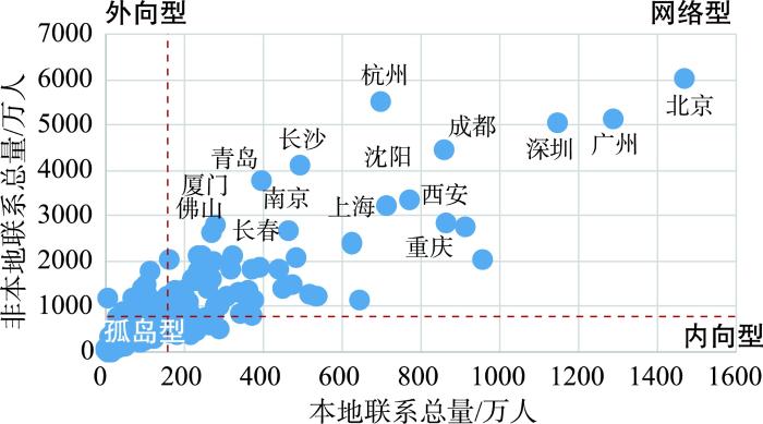
图1
本地与非本地联系的城市类型象限图
Fig.1
Quadrants of city types with local and non-local connections
其中,网络型城市有63个,数量占所有城市的21.50%,从图2可以明显看出,网络型城市几乎都分布在较为成熟的珠三角、长三角、京津冀、成渝、关中平原城市群。外向型城市有31个,数量占所有城市的10.58%,外向型城市多为一些发展水平较低的省会城市,由于政策和资金的倾斜,使得这些城市有较高的非本地联系总量,但受其自身发展条件的限制,难以在城市内部形成密集的互动网络,因此本地联系总量较低。内向型城市有27个,数量占所有城市的9.22%,从城市类型的空间分布图(图2)来看,大部分内向型城市都分布在发展较好的网络型城市周边,说明网络型城市在一定程度上会限制周边城市的对外联系,周边城市会受虹吸效应的影响而存在“灯下黑”的现象。值得注意的是,孤岛型城市有172个,占比高达58.70%,说明中国大多数城市在中国城市网络中的影响力较小,还有待进一步发展。整体来看,网络型城市、外向型城市以及内向型城市几乎都分布在“胡焕庸线”以东的区域,这种不均衡分布模式与中国长期存在的“东—西”差距基本吻合。
图2
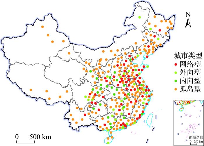
图2
本地与非本地联系的城市类型分布
注:本图基于自然资源部标准地图服务系统网站下载的审图号GS(2020)4630号的标准地图绘制,底图无修改。海南三沙市、西藏那曲市、甘肃嘉峪关市和张掖市以及港澳台地区城市因数据缺失未包含在内。下同。
Fig.2
Distribution of city types with local and non-local connections
2.1.2 中国城市网络节点层级划分
图3
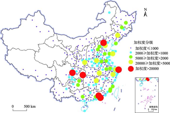
图3
中国城市网络节点加权度空间分布
Fig.3
Spatial distribution of node weighted degree of the urban network in China
表1 中国城市网络节点层级划分
Tab.1
| 层级(加权度) | 城市 |
|---|---|
| 国家级网络中心 (加权度>20000) | 北京、重庆、上海、广州、深圳、成都 |
| 国家级网络副中心 (20000≥加权度>5000) | 郑州、苏州、西安、杭州、东莞、天津、长沙、武汉、青岛、沈阳 |
| 区域网络中心 (5000≥加权度>2000) | 佛山、哈尔滨、南京、合肥、厦门、长春、济南、徐州、保定、南宁、贵阳、石家庄、福州、泉州、商丘、大连、遵义、 潍坊 |
| 地方网络中心 (2000≥加权度>1000) | 阜阳、昆明、周口、株洲、惠州、宁波、许昌、金华、南阳、泸州、六安、温州、太原、临沂、烟台、平顶山、咸阳、 运城、南昌、菏泽、无锡、新乡、洛阳、赣州、中山、邯郸、贺州、漳州、邵阳、珠海、南通、焦作、盐城、宜宾、日照、渭南、三亚、自贡、衡阳、嘉兴、驻马店、北海、连云港、淮安、汕头、呼伦贝尔、绵阳、乐山、宿迁、秦皇岛、威海、廊坊、聊城、上饶、毕节、南充、吉林 |
| 地方附属节点 (加权度≤1000) | 茂名等202个城市 |
从划分的5个不同层级来看,国家级网络中心主要包括京津冀、长三角、珠三角、成渝4个城市群的核心城市北京、重庆、上海、广州、深圳、成都,其在城市群内的较强影响力和控制力使其在自媒体时代中处于绝对优势地位。国家级副网络中心包括郑州、苏州、西安等10个城市,其中,除沈阳以外均为《2022城市商业魅力排行榜》中的“新一线”城市。然而,个别“新一线”城市(佛山、南京、合肥、宁波等)仅位于“区域网络中心”或“地方网络中心”的行列,这与现有的城市等级体系并不完全一致。这也符合以往网络空间的相关研究结论,网络空间是地理空间的延伸,但同时短视频社会化时代背景下的数字经济正在重塑中国原有的城市等级体系[28]。
其中,值得注意的是重庆和西安:重庆在基于抖音社交平台的城市网络中加权度排名第二,超过了上海、广州和深圳,并且和“北上广深”跻身“国家级网络中心”行列;西安在2021年地区生产总值中排名第24位,但是其在基于抖音社交平台的城市网络中加权度排名第9位,并且和苏州、杭州、天津等地区生产总值排名较高的城市共同构成“国家级副网络中心”。对于重庆和西安而言,首先,重庆作为山城、西安作为十三朝古都,独有的空间特色和文化底蕴都为其构建了扎实的基底;其次,在当今自媒体时代,重庆、西安抓住短视频平台的巨大影响力,重庆“穿楼而过的轻轨”“巴渝文化特色的吊脚楼”以及西安“摔碗酒”“毛笔酥”“不倒翁小姐姐”等短视频红遍网络;最后,当地文化和旅游局等政府机构也在抖音社交平台开通了账号并且发布城市相关短视频,借力短视频进行自我营销的方式使得两市的火爆程度超过了很多传统旅游城市,从而在视频社会化时代一跃成为“网红城市”。这也表明,在视频社会化时代,城市的特色空间、独特的文化底蕴是构建抖音社交平台城市网络的核心要素,短视频平台的助力让城市网络迎来新的发展机遇。
2.2 城市网络结构特征
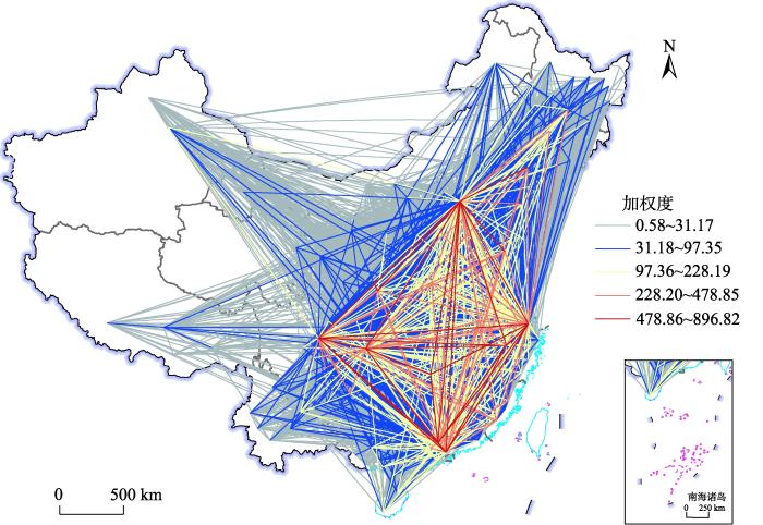
城市网络的结构特征需要考虑的是2个节点之间的联系流,因此,将原先的有向网络转换为无向网络,一共11000条联系流,将边权值分为5个等级进行分析。从中国城市网络空间联系结构图(图4)来看,整体城市网络还是以“胡焕庸线”为分界线,呈现出较为明显的东强西弱的空间格局。其中,在高值联系流上又凸显出一个“三棱锥结构”,京津冀城市群、长三角城市群、珠三角城市群以及成渝城市群分别构成这个锥体的4个顶点,各个城市群之间的相互联系构成了这个锥体的6条边。值得注意的是,以长沙为核心的长江中游城市群已经在“三棱锥结构”的投影下逐渐发展成了网络结构中的重要节点,这一点在地理空间和虚拟空间之间呈现出了很大的相似性,同时,也表明在“十四五”规划中属于“优化提升”范围的5大城市群已经初见成效。在“三棱锥结构”以外,可以明显看到高值联系流也存在于京津冀城市群和以西安为核心的关中平原城市群、以青岛为核心的山东半岛城市群以及以沈阳为核心的辽中南城市群之间,说明在“十四五”规划中属于“发展壮大”范围的城市群中山东半岛、关中平原城市群已经较为成熟。从图4也可以看到,中原和粤闽浙城市群也已有雏形,而北部湾城市群尚未成形,未来有待发展;辽中南城市群作为“十四五”规划中“培育发展”范围的城市群已经相对成熟,成为了“培育发展”行列最有潜力的城市群,未来应该重点培育以带动哈长城市群的快速发展。
图4
本文利用Gephi对中国城市网络的拓扑结构进行分析,对平均聚类系数和平路径长度进行计算,以考察中国城市网络结构的集聚性和可达性。计算结果显示,平均聚类系数为0.373,平均路径长度为2.371。为了更加直观地分析视频社会化时代背景下中国城市网络的集聚性和可达性,本文选取了企业流、交通流和人口迁徙流进行了对比分析⑤(⑤ 资金流和知识流因缺少拓扑结构的相关数据,故未纳入对比分析中。),其中,与公路联系和铁路联系相比,航空流主要反映全国尺度的空间关系[36-37],所以选取航空网络的研究结果为交通流的对象。从企业流来看,基于上市公司数据的中国城市网络的平均聚类系数为0.565,平均路径长度为1.94[6]。从交通流来看,基于航空数据的中国城市网络的平均聚类系数为0.69,平均路径长度为2.23[38]。从人口迁徙流来看,基于位置服务(location based services, LBS)数据的中国城市网络的平均聚类系数为0.61,平均路径长度为1.86[9]。可见,基于抖音数据的中国城市网络与基于传统数据的中国城市网络相比,平均聚类系数更低,平均路径长度更大,表明在视频社会化时代中国城市网络更加分散,进一步证实了信息时代打破了空间的隔阂,通过互联网缩短了交流的距离,使得不同地域、不同文化、不同语言之间都可以实现紧密交流。
3 城市中心性的影响因素
3.1 影响因素的筛选和处理
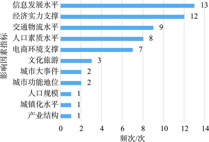
视频社会化时代背景下,短视频平台通过直播带货等形式重新定义了传统网络购物和电子商务,本文对相关研究中[18,26,29,31⇓⇓-34]影响因素进行了频数统计,结果如图5所示。结合对文献的总结和梳理,考虑到各个影响因素计算指标的可量化性和数据的可获取性,最终选取频次较高的经济发展水平、信息发展水平、物流发展水平、人力资本水平以及旅游发展水平5个方面来定量分析视频社会化时代中国城市中心性的影响因素。具体而言,选取人均地区生产总值,第三产业占地区生产总值的比重以及社会消费品零售总额代表经济发展水平;选取互联网宽带接入用户数,信息传输、计算机服务和软件业从业人员数以及淘宝村数量代表信息发展水平;选取物流网点数量,交通运输、仓储和邮政从业人员数以及邮政业务收入代表物流发展水平;选取普通本专科人员数,中等职业教育学校人数以及专利授权数代表人力资本水平;选取A级景点数量,住宿和餐饮业从业人员数以及旅游收入代表旅游发展水平。
图5
本文以中国各个城市的加权度为因变量,以上述连续型指标为自变量,利用最优参数地理探测器对视频社会化时代中国城市中心性的影响因素进行了分析,各个指标的描述性统计以及q值最高的参数组合(分级方式和间断数量)如表2所示。
表2 各个指标的描述性统计以及q值最高的参数组合
Tab.2
| 影响因素 | 代表指标 | 最大值 | 最小值 | 平均值 | 分类方法 | 间断数量/类 |
|---|---|---|---|---|---|---|
| 经济发展水平 | A1 人均地区生产总值(元) | 203489 | 14746 | 63033.74 | 等间距分类 | 11 |
| A2 第三产业占地区生产总值的比重(%) | 83.52 | 28.33 | 49.13 | 几何间距分类 | 6 | |
| A3 社会消费品零售总额(万元) | 158475530 | 448902 | 13767916.74 | 自然断点法分类 | 8 | |
| 信息发展水平 | B1 互联网宽带接入用户数(万户) | 1372 | 7 | 150.62 | 标准偏差分类 | 9 |
| B2 信息传输、计算机服务和软件业从业人员数(人) | 859131 | 192 | 15658.27 | 几何间距分类 | 12 | |
| B3 淘宝村数量(个) | 508 | 0 | 23.08 | 自然断点法分类 | 9 | |
| 物流发展水平 | C1 物流网点数量(个) | 6405 | 0 | 537.27 | 等间距分类 | 6 |
| C2 交通运输、仓储和邮政从业人员数(人) | 589525 | 764 | 25327.30 | 自然断点法分类 | 12 | |
| C3 邮政业务收入(万元) | 13658685 | 7 | 339342.07 | 分位数分类 | 12 | |
| 人力资本水平 | D1 普通本专科人员数(人) | 1152994 | 2392 | 110434.99 | 等间距分类 | 5 |
| D2 中等职业教育学校人数(人) | 414203 | 117 | 42683.69 | 几何间距分类 | 5 | |
| D3 专利授权数(件) | 166609 | 0 | 9068.68 | 几何间距分类 | 8 | |
| 旅游发展水平 | E1 A级景点数量(个) | 270 | 0 | 41.50 | 自然断点法分类 | 9 |
| E2 住宿和餐饮从业人员数(人) | 575864 | 100 | 12189.31 | 标准偏差分类 | 5 | |
| E3 旅游收入(百万元) | 422578.01 | 483.33 | 35133.68 | 等间距分类 | 5 |
3.2 全国层面城市中心性的影响因素
采用参数最优地理探测器的因子探测识别单因子对视频社会化时代中国城市中心性的解释力。从图6可以看出,因子探测结果为A3>B1>B2>C1>E3>E1>A1>A2>B3>D3,其余因子解释力P值均大于0.01。从结果可以看出,主要影响因子为社会消费品零售总额,互联网宽带接入用户数以及信息传输、计算机服务和软件从业人员数,决定力均在0.8以上,说明经济发展水平和信息发展水平是视频社会化时代中国城市中心性的主要影响因素。对于经济发展水平而言,经济实力发达的地区容易吸引更多的资本和更专业的运营团队,在资本和运营的双重带动下,更容易孵化吸引力较强的达人,从而提升城市在中国城市网络中的中心性。对于信息发展水平而言,信息化水平可以在视频社会化时代保障良好的运行效率和即时通讯能力,从而大幅提升短视频达人直播视频的体验感与交互性,信息化水平发展较好的地区更能为粉丝构建身临其境、深度互动的直播环境。
图6
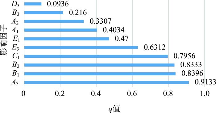
同时,次要影响因子为物流网点数量和旅游收入,决定力在0.6以上,说明物流发展水平和旅游发展水平也对视频社会化时代中国城市中心性具有一定的影响力。视频社会化时代可以通过提高视频内容质量和直播带货效率来实现短视频账号的引流,从而提高短视频账号的关注度,增加达人的粉丝量。对于物流发展水平而言,从达人的视角出发,便利的物流条件可以大幅降低商品供应链中的运输成本,从而吸引更多的带货达人集聚;从粉丝的视角出发,密集的物流网点可以提升消费者的购物体验,使得产品的退换货流程都更为便捷,同时也更加贴合现代人追求的“无缝消费体验”。对于旅游发展水平而言,旅游吸引力更高的地区可以为吸引粉丝提供文化资本,更容易催生高质量的视频内容,从而吸引更多的粉丝关注这些地区,使得视频社会化时代城市的中心性实现螺旋式上升。
最后,值得关注的是在人力资本水平中,只有专利授权数具有显著性,且其决定力低于0.1,说明人力资本水平对于视频社会化时代中国城市的中心性影响较小。这也符合视频社会化时代的“人人皆可拍”的时代特征,短视频平台达人入驻的门槛较低,使得其真正地走向社会化。同时,在短视频平台更多达人是通过视频内容妙趣横生而走红,这也说明人力资本水平对达人的关注度影响较小。
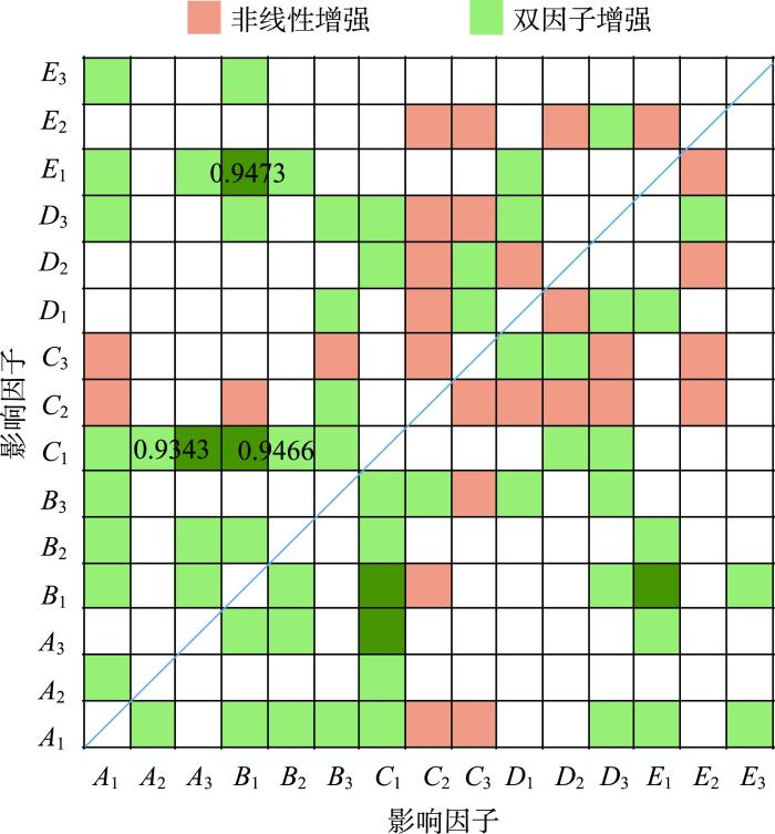
交互探测结果显示(图7),不同影响因子交互后表现为非线性增强和双因子增强2种组合,其中大部分为双因子增强。可见,基于抖音社交平台的城市中心性主要是多个影响因子综合作用的结果。其中交互作用最大的影响因子为A级景点数量和互联网宽带接入用户数、物流网点数量和互联网宽带接入用户数以及物流网点数量和社会消费品零售总额,其交互决定力都在0.93以上。可以看到物流网点数量和互联网宽带接入用户数不仅单因子影响力较高,当该影响因子随其他影响因子一起提高时,也会对中国城市的中心性具有较强的推动作用。值得注意的是,A级景点数量单因子检测结果显著性排第6位,但是其和互联网宽带接入用户数交互作用以后决定力达到最高,说明信息水平对于旅游产业的发展至关重要,信息水平的高速发展可以为旅游业的发展提供更为广泛的传播途径,从而大幅提升旅游地区的吸引力和关注度,所以两者共同提高时,对视频社会化时代中国城市中心性有较强的影响力。
图7
3.3 区域层面城市中心性的影响因素
由于以往对于京津冀、长三角、珠三角、成渝、中原等“三棱锥结构”以内区域的研究较多,故本文选取了“三棱锥结构”以外的区域进行研究,从而挖掘中国城市网络进一步发展的着力点,为提高周边城市在视频社会化时代中国城市的中心性提供针对性的建议。结合地理位置以及数据分析的可行性,本文将黑龙江省、吉林省、辽宁省划分为东北地区;将新疆维吾尔自治区、西藏自治区、青海省、甘肃省、宁夏回族自治区划分为西北地区;云南省、贵州省、广西壮族自治区划分为西南地区。从表3可以看出,不同区域的城市中心性均受信息发展水平和物流发展水平影响较大,同时,不同区域也表现出了较明显的空间差异。
表3 分区域城市中心性影响因素的地理探测结果
Tab.3
| 区域 | 因子探测 | 交互探测 | ||||
|---|---|---|---|---|---|---|
| 主要因子 | q值 | 最大交互作用因子 | q值 | 交互类型 | ||
| 东北地区 | B2 | 0.9216 | B1∩B2 | 0.9653 | 双因子增强 | |
| C1 | 0.8652 | |||||
| E3 | 0.8531 | |||||
| 西北地区 | A3 | 0.8719 | A2∩A3 | 0.9303 | 双因子增强 | |
| C1 | 0.8012 | |||||
| B2 | 0.7974 | |||||
| 西南地区 | B2 | 0.7365 | C1∩C3 | 0.8942 | 非线性增强 | |
| C1 | 0.7198 | |||||
| B1 | 0.6931 | |||||
东北地区城市中心性的主要影响因素除了信息发展水平和物流发展水平之外,还受旅游发展水平影响较大。东北地区的主要影响因子除了信息传输、计算机服务和软件业从业人员数以及物流网点数量以外,还有旅游收入决定力达到了0.8531。东北地区无论是从地理位置、旅游资源,还是历史渊源,都可以称得上是中国参与东北亚区域旅游合作的主导角色,加之东北地区“产业转型”的发展理念,使得旅游业的发展成为东北地区城市中心性的重要影响因素。
西北地区城市中心性的主要影响因素除了信息发展水平和物流发展水平之外,还受经济发展水平影响较大。西北地区的主要影响因子除了信息传输、计算机服务和软件业从业人员数以及物流网点数量以外,还有社会消费品零售总额的决定力达到了0.8719。并且最大交互作用的因子为第三产业占地区生产总值的比重和社会消费品零售总额,其交互决定力达到了0.9303。西北地区改革开放时间相对较晚,解放后的发展也主要依靠国家投资,在各种政策的倾斜下造成了省会城市一城独大的局面,使得经济发展水平成为西北地区城市中心性至关重要的影响因素。
西南地区城市中心性的主要影响因素为信息发展水平和物流发展水平。西南地区的主要影响因子为信息传输、计算机服务和软件业从业人员数,物流网点数量以及互联网宽带接入用户数,最大交互作用因子为物流网点数量和邮政业务收入,且其交互类型为非线性增强,即两者交互作用的决定力大于单因子决定力之和,足以见得物流发展水平对于西南地区的城市中心性影响更大。随着西部大开发的深入实施,在国家财政的大力扶持下,西南地区逐步完善路网结构,建设西南出入境铁路,鼓励外资在西南地区开展物流服务,这些都为西南地区的物流发展创造了前所未有的机遇,使得其成为西南地区城市中心性的重要影响因素。
综上,不难发现,在视频社会化时代,城市的经济发展水平是基底,信息发展水平和物流发展水平是媒介,旅游发展水平是催化剂。在这些因素的共同作用下,城市在网络中的中心性才能得以提升,进而带动整个网络的健康发展,加速虚拟网络和地理网络的良性互动。然而,由于地理位置、政策倾斜以及发展路径的不同,不同地区处于不同的发展阶段,这也导致了不同地区主要影响因素的差异性。由于改革开放的时间晚于别的地区,西北地区经济发展水平也相对较低,技术型人才比较缺失,还未形成视频社会化时代城市发展的坚实基底。从西南地区来看,在“西部大开发”政策的扶持下,经济发展水平已经有了一定幅度的提升,但受限于地形地势,在信息和物流发展过程中存在一定的阻力,从而使得城市在网络中的中心性受限。而东北地区由于其天然的幽默基因,使得其社交平台的发展起步较早,拥有坚实基底的同时已经具备了完善的信息设施和成熟的物流体系,因而东北地区在城市网络中中心性的进一步提升亟需旅游发展水平的催化。
4 结论与讨论
4.1 结论
基于抖音平台达人和粉丝数据,本文采用社会网络分析方法,从中国城市网络节点特征和结构特征两个方面剖析了基于抖音社交平台的城市网络特征,借助参数最优地理探测器分析了全国层面城市中心性和区域层面城市中心性的主要影响因素。主要结论如下:
(1) 从中国城市网络节点的角度来看:基于本地与非本地联系对城市进行分类,孤岛型城市占比最高,网络型、外向型和内向型城市基本都分布在“胡焕庸线”以东的区域,这种不均衡分布模式与长期存在的“东—西”差距基本吻合;但是,基于抖音社交平台的城市等级并不完全遵循传统的城市等级体系,很多“新一线”城市仅承担着区域网络中心或地方网络中心的作用。
(2) 从中国城市网络结构的角度来看:整体网络呈现出了“三棱锥结构”,京津冀城市群、长三角城市群、珠三角城市群以及成渝城市群分别构成这个锥体的4个顶点,与“十四五”规划中城市群的发展格局具有极大的相似性;在此基础上,视频社会化时代中国城市网络更加分散,进一步证实了信息时代打破了空间的隔阂。
(3) 对于全国层面城市中心性,其主要影响因素为经济发展水平和信息发展水平,次要影响因素为物流发展水平和旅游发展水平,并且各因素之间存在较强的交互作用;值得注意的是,人力资本水平对视频社会化时代中国城市中心性影响较小,这也符合视频社会化时代的“人人皆可拍”的时代特征。
(4) 不同区域的城市中心性均受信息发展水平和物流发展水平影响较大,同时,不同区域也由于其发展阶段不同表现出了较明显的空间差异。西南地区受物流发展水平影响更大,东北地区除此之外受旅游发展水平影响较大,西北地区除此之外受经济发展水平影响较大。
4.2 讨论
随着互联网技术的进一步发展,未来各城市间的竞争越发激烈,在提升城市硬实力的同时,短视频平台也为城市带来了很多发展机遇。通过视频社会化时代中国城市网络特征及其影响因素研究,提出以下发展建议。对于不同地区的城市来说,为了提高其在视频社会化时代中国城市中心性,完善中国城市网络,需要在经济、信息、物流以及旅游发展水平等方面有侧重、有区别地进行提升。东北地区在完善物流基础设施的同时,要侧重于发展旅游产业,结合“抖in city”等抖音潮流玩法,借力“头部达人”为城市代言,加速发展旅游网红新经济,打造类似西安、重庆等城市的“抖音之城”;西北地区应该加速提升经济发展水平,消除不平衡不充分发展的矛盾,以现有产业结构为基底,借助短视频平台的直播电商板块,结合抖音电商“山货上头条”等特色活动,将西北地区传统农业产业打造为推动西北地区发展的坚实力量;西南地区应该在提升信息发展水平的同时稳步完善物流基础设施建设,依托重点城市建立区域物流中心,辐射、带动周边物流发展,形成畅通高效的西南物流走廊,从而为短视频社会化时代的直播电商发展创造便捷的环境基础。
同时,视频社会化时代“人人皆可拍”的特征使得时代信息逐步向不同的渠道开放,草根阶层成为了新时代城市网络中的主力军。正如Castells[39]所说,虽然流空间仍然运行着占有支配地位的活动,但同时也经历着草根阶层(grassroots)日益增长的影响和压力,这一过程可能会对我们的社会带来改变,从而达到在流空间中实现电子空间和场所空间的互动。在新的时代背景下,草根阶层从“沉默的大多数”转变为新的意见阶层,和精英阶层共同成为公共决策者,传统意义上的“媒介”已经被弱化,反而很多热点事件都是由短视频用户发布、形成舆论漩涡,传统意义上的媒体才开始跟进。这种电子空间和场所空间的互动也为城市的发展带来了机遇,新的意见阶层为城市的发展带来了不同维度的引导,使得“全过程人民民主”的城市建设成为可能。
这是对视频社会化时代背景下中国城市网络的一个新的尝试,但是对比不同数据源下的中国城市网络结构可以发现,交通流、资金流、企业流、知识流、人口迁徙流等形成的中国网络结构相似度极高,都表现出了“三棱锥结构”的网络形态,这也证明了抖音数据作为中国城市网络研究的有效性。但抖音数据涵盖的人群偏向于网络使用人群,缺乏了部分未使用网络的青少年和中老年样本,这也会使研究结果存在一定的误差,有待和传统数据相结合进一步挖掘更为全面的中国城市网络特征及其影响因素。
参考文献
信息技术影响下的区域城市网络: 城市研究的新方向
[J].
Regional urban network influenced by information technology: New directions of urban studies
多元流视角下东北城市网络特征分析
[J].
Analysis of network characteristics of northeast cities from the perspective of multi-Flow
高速铁路对城市网络结构的影响研究: 基于铁路客运班列分析
[J].
DOI:10.11821/dlxb201602007
[本文引用: 1]

城市网络是近年来城市与区域研究的一个新方向.基于2003-2013年间8个横截面的中国铁路客运班列数据,采用加权度中心性和社区结构模型,探讨高速铁路建设对城市等级和集聚性空间格局及演化的影响.研究表明:① 基于铁路客运组织的城市等级结构呈现出位序--规模分布的特征和集聚性,且三大地带和各社区内城市也呈现出明显的位序--规模分布,随着高速铁路网络的扩展,加权度中心性的集聚性更明显,并逐步呈现出较为明显的层级结构和社区结构.② 城市等级结构呈现出明显的东中西地带性,廊道效应和经济,人口的耦合性,即基于铁路客运班列的城市等级结构与基于属性数据(人口/GDP)的结果表现出较大的相似性,但也存在一定的差异.城市社区结构与中国高速铁路网络,城市群的空间分布格局基本一致.随着高速铁路的建设,东中西三大地带间城市等级的差异呈扩大态势,但各社区间城市等级的差异呈缩小态势,部分社区核心城市已形成.
Impact of high-speed rail on inter-city network based on the passenger train network in China, 2003-2013
DOI:10.11821/dlxb201602007
[本文引用: 1]
The evolution of inter-city network influenced by globalization and information technology has become a hot topic in city and urban research. This study tries to explore the evolution of nodal hierarchy and communities in inter-city network based on passenger train network during the rapid development period of High-speed Railway (HSR) in China since 2003. Results indicate that: (1) the evolved HSR network in China enlarged the disparities of weighted degree centrality between regions, but decreased the disparities of that between communities, and led to an increasing concentrated city hierarchy with fewer cities having high centrality value, and a growing similarity between the city hierarchies measured by the passenger train network and by city attributes (such as population and GDP); (2) the city hierarchy measured by passenger train network followed a rank-size distribution in the national and regional levels, as well as in some communities. (3) Spatially, cities with higher hierarchy in passenger train network and larger improvement in weighted centrality indicator were mostly located in the eastern region or the areas with the distance to the nearest HSR stations below 50 km, developed economy and high population density; the cities in 2013 could be divided into 14 communities, including the communities with cities mainly located along Beijing-Shanghai, Beijing-Wuhan and Wuhan-Chengdu, Wuhan-Guangzhou, Beijing-Jiujiang, Hangzhou-Xiamen, Lanzhou-Urumqi trunk rail lines, and located in Northeast China, Shanxi Province, Inner Mongolia. (4) The evolution of communities was mostly influenced by the natural environment and administrative areas, especially by the development of HSR network.
多元交通流视角下的中国城市网络层级特征
[J].
DOI:10.11821/dlyj2015110006
[本文引用: 1]
交通流是人流、物流等要素流动的主要载体和表现形式,对于认识城市间相互作用等具有重要意义。基于城市间公路、铁路和航空客流数据,对中国城市网络空间关联进行特征提取和规律挖掘。研究表明:① 公路流表现出强烈的空间依赖性和对城市群发育程度的良好识别作用;② 铁路流呈现出“两横三纵”带状分布格局;③ 航空流视角则基本形成了以“菱形结构”为核心的城市网络框架。不同类型交通流刻画出不同层面的城市间关联格局,但却有着其内在联系。航空流是城市关联格局骨架构筑的主要形式,铁路流则为核心骨架的连通提供支撑轴带,而公路流是对整体骨架和支撑轴带的有效填充,从而形成区域间相互依赖、不可或缺的要素关联和空间关系。
Hierarchical structures of China's city network from the perspective of multiple traffic flows
DOI:10.11821/dlyj2015110006
[本文引用: 1]
Traffic flow acts as a major carrier of other flows (including people, goods, capital, etc.), thus the study on traffic flow is of great significance to understand intercity interaction. Based on the 321 cities at prefecture level or above, this article explores spatial linkage of China's city network using intercity linkage data of road, rail and air transport. The research results show that: (1) The spatial correlation of city network based on road linkage displays strong spatial dependence, which is very useful to identify urban agglomerations and assess developments. Besides the most developed regions including Yangtze River Delta, Pearl River Delta and Beijing-Tianjin-Hebei urban agglomerations, some important urban agglomerations have emerged, such as Zhongyuan, Harbin-Daqing-Qiqihar, Central Jilin, Central-southern Liaoning, Shandong Peninsula, Guanzhong, West coast of Taiwan Straits, Wuhan, Central Yunnan, Changsha-Zhuzhou-Xiangtan. (2) The railway linkage flow reflects intercity external connection pattern, regional element relevancy and regional accessibility along with national railway artery. "Two horizontal and three longitudinal" zonal distribution patterns composed of Beijing-Guangzhou, Beijing-Harbin, Beijing-Shanghai Railway and Longhai-Lanxin, Shanghai-Kunming Railway, constitute the urban network backbone and have become the most important economic axial belts for national territorial development. (3) The "diamond structure" as the core framework basically forms the skeleton of urban network system from the perspective of air passenger flow, whose vertices are Beijing, Shanghai, Guangzhou-Shenzhen and Chengdu-Chongqing. Generally speaking, different types of traffic flows reflect different patterns of intercity linkage, namely, there also exists internal relationship. Air passenger flow constitutes the backbone of intercity linkage pattern, railway linkage flow acts as supporting axis belts for the core framework, and road linkage is a bridge connecting main skeleton and supporting belts. All types of traffic flows collectively form interdependent and indispensable element correlation and spatial relationship among regions.
中国城市网络化空间联系结构: 基于银行网点数据的研究
[J].
DOI:10.18306/dlkxjz.2017.04.001
[本文引用: 1]
基于当前城市网络和金融地理研究,以全国336个地级以上行政单元(城市)为研究对象,以33家国内外银行的88022个网点各城市间的级别和数量分布为基础数据,运用链锁模型、Zipf法则、社会网络分析等研究方法,对中国市间联系和城市节点的结构特征进行分析。研究表明:京津冀、长三角、珠三角、成渝和长江中游等五大城镇密集区之间的联系成为这一网络的主干,东西部网络密度以胡焕庸线为界呈现明显差异;城市联通度的规模分布符合Zipf法则,但呈现明显的双分形特征,各城市的节点度同样以胡焕庸线为界在东西部呈现显著差异;此外,国有银行、股份制银行和外资银行所分别对应的城市整体联通度和相对联通度在空间分布上也存在明显差别;上述结构特征同各城市经济规模和人口规模之间存在较强的相关性。从形成机制上看,朝向集中化和均衡化的一般空间政策和行业空间政策对这一网络格局的形成具有深刻影响。
Network spatial connection structure of Chinese cities based on bank branches data
DOI:10.18306/dlkxjz.2017.04.001
[本文引用: 1]
This article analyzes the structural features of China's city network based on bank branches data covering 33 domestic and foreign banks as well as 336 urban administrative regions. The data, which includethe spatial distribution of these branches and their ranks and quantity, are processed using the interlocking world city network (IWCN) model, Zipf law, and social network analysis (SNA). The conclusions are as follows. (1) The connections between five major city agglomerations (Beijing-Tianjin-Hebei, Yangtze River Delta, Pearl River Delta, Chengdu-Chongqing, and the middle reaches of the Yangtze River) serve as backbones of the network, and a significant difference of network density between eastern and western China as divided by the Hu Line is discovered. (2) The urban size distribution of interlock connectivity conforms to the Zipf law with a double fractal, and the distribution of each city's degree also suggests a significant difference between cities in eastern and western China. (3) The overall and relative interlocking connectivity of the top 50 large cities vary according to the types of banks that include state-owned, joint-stock, and foreign-owned. (4) A relatively strong correlation between connectivity and economic/population size of cities are also found. The structure of this urban network can be interpreted in terms of general spatial policy and industrial spatial policy, in which the interplay between differentiation and equalization shapes the unique and changing pattern of China's interurban bank network.
基于上市公司数据的中国城市网络空间结构
[J].
Spatial structure of Chinese intercity network based on the data of listed companies
基于人才流动的城市网络关系构建
[J].
DOI:10.11821/dlyj201701013
[本文引用: 1]
以高端归国人才为对象,通过构建“归国人才三角”概念框架,设计基于高端移动性人才的城市关系构建方法,对人才迁移驱动的城市网络构建进行了初步探讨。研究认为:① 借助“行动者空间移动带来的空间动力”这一视角,运用高端归国人才在城市间的移动模拟城市间关系,可为构建城市网络提供一条新路径。② 基于人才流动的城市网络构建,有助于破解城市关系矩阵数据挖掘与案例城市选取的难题,是知识经济时代城市网络研究的新方向。③ “归国人才三角”概念框架将人才流动与城市网络两方面研究融为一体,既可以通过人才流动探讨城市创新空间组织特征,也可以通过城市网络方法分析人才流动网络,对城市网络研究和人才战略实施都具有一定参考价值。
Triangle model of Chinese returnees: A tentative method for city networks based on talent flows
DOI:10.11821/dlyj201701013
[本文引用: 1]
As one of the important contents of urban geography, regional urban spatial organization is turning from the traditional city system research to the city networks research. There are two methods to construct city networks. One is using the relational data including the goods flow, capital flow, information flow, population flow among the city to construct city networks; the other one is building models to simulate the relationship between the city, such as interlocking network model and the gravity model. Inspired by the view of the "a spatial dynamic that changes whenever actors move in space" proposed by Menzel, this paper attempts to construct the city networks by using returnees' movement between cities. First, this paper discusses the theoretical relationship between talent mobility and city network. Relational economic geography uses the idea of "based on construction of individual relationship " into network analysis, evolutionary economic geography puts forward the thought of "dynamic proximity", and the research of early uses mobility of talents of high technology to measure the relationship between cities. These had laid a theoretical foundation for the construction of the city network based on the flow of talents movement. Then, we establish the conceptual framework of "triangle model of Chinese returnees". The returnees have the fellow villager's relationship resources in their native places, the classmates' relationship resources in overseas cities and the coworkers' relationship resources in the work city, and these are used in the analysis framework. By integrating the migration data of the returnees, we establish the cities' connections based on the flow of talent, and design a method to calculate the city connectivity. Finally, we select 6 high-end returnees of an innovative team in China to carry out a case analysis. Through the mining of the returnees' city resumes, we successfully construct the city network composed of six talents. As a result, it is suggested that: (1) city innovation network should be examined at national scale under global perspective, and the returnees are good carriers in such researches; (2) the "triangular model" reflects Chinese characteristics, which can explain the formation mechanism of city innovation network better; (3) the returnees team in Beta Pharma Co., Ltd is a typical case that it successfully facilitates inter-city innovation cooperation; and the "triangular model" framework provides a brand-new perspective and analytical method to further research on city innovation network. It should be noted that this paper focuses on theory construction and method exploration, and it needs to use a great quantity returnees' data to carry out systematic research on urban network in the next step, in order to make a greater contribution to urban network theory and the strategy of talents creative practice.
春运人口流动透视的转型期中国城市网络结构
[J].
DOI:10.13249/j.cnki.sgs.2016.11.007
[本文引用: 1]
基于春运人口流动大数据,选取对外联系度、优势流、城市位序-规模分析等方法对转型期中国城市网络特征进行分析。结果显示:① 城市网络层级结构中蕴藏着位序-规模规律,但与理想的帕累托分布有所区别,城市规模彼此差异相对较小;② 空间距离与城市等级在城市网络联系中发挥支配性作用,保证了城市网络的层级性与有序性;③ 中国城市网络核心联系呈现“两横三纵”特征,该特征与铁路大动脉的空间分布高度吻合;④ 东部地区城市网络联系更加密切,而西北、西南地区则相对稀疏,基本上以“胡焕庸线”为界,而“兰新线”是突破这一限制的潜在力量;⑤ 中国东北地区未形成明显的区域性中心,城市联系形成带状网络;⑥ 华北与华南地区的“灯下黑”现象值得警惕,缓解这一问题的可行办法是核心城市功能的对外疏散,加强核心城市与周边城市之间的联系;⑦ 带状区域发展或许将成为未来中国区域经济发展的流行模式和中坚力量。总体上看,针对于揭示转型期中国城市网络结构特征,春运人口流动数据具有一定的研究价值,是城市与人口研究领域一个值得深入挖掘的重要数据源。
Spatial pattern of city network in transitional China based on the population flows in "Chunyun" period
DOI:10.13249/j.cnki.sgs.2016.11.007
[本文引用: 1]
<p> The space of flows theory proposed by Manuel Castells has given birth to the network perspective of city network. In contrast with the traditional perspective of urban system which is based on the central place theory, city network perspective pays more attention to the interactions and linkages between cities and regions. Thus, the city network is becoming one of the new and hot topics in the field of urban geography. “Chunyun” is a well-known socio-economic phenomenon unique to transitional China, which refers to a blooming of population flows during the Spring Festival, or refers to the period when the blooming happens. Previously, the real population flows data in “Chunyun” were difficult to obtain. The situation had not changed until the “Big data on human migration during the spring festival from Baidu map” (“Baidu migration data” in short) came up. The big data were gathered from the locations provided by hundreds of millions smart phone users through Location Based Service (LBS) Baidu map data source, and was published in the form of interactive heat map that displays people’s travel routes in China during the Chunyun period. Based on Baidu migration data, using degree of external linkages, dominant flows and network-based rank-size analysis, the spatial pattern of city network in transitional China was studied in this article. The study process certificates that Baidu migration data is indeed a high quality data sources for the study of city network, and has turned up some interesting results: 1) The distribution of external linkage degree of cities in China follows Zipf’s law, but differs from the ideal Pareto distribution. 2) The factor of spatial distance and city level play key roles in the formation of urban network of China, and ensure the hierarchy and regularity of the network. 3) The spatial distribution of core linkages in the city network could be summarized as “Three-horizontal & Two-longitudinal”, which almost coincides with the rail arteries in China. The “Three-horizontal & Two-longitudinal” linkages are skeletons of the city network, which matter a great deal in building the interregional contact and coordinating the interregional relationship. 4) In overall, the strength of interactions within the city network differs between East and West China, and Hu's line is apparently the dividing line. As potential powers, the linkages along the Lanzhou-Xinjiang railway line have the opportunity to break the Hu's line. 5) Northeast China lacks regional centers and the linkages between cities forms a bunchy network. 6) There is a phenomenon of “near field deprivation” in North China and South China, that is, the core city have strong interactions with outer regions, but the smaller cities in its near field have poor external linkages with the core city and outer regions. 7) Belt-shaped region may become a popular mode and the future backbone of regional economic development in China.</p>
基于百度迁徙数据的中国城市网络结构特征研究
[J].
DOI:10.12082/dqxxkx.2021.210223
[本文引用: 4]
迁徙流作为互联网时代的新产物,信息流、资本流、交通流等流空间的基本载体,能客观地反映城市间地理行为关系,对于刻画城市网络结构具有重要意义。基于地级以上城市的百度迁徙大数据,本文尝试从全域和净迁徙的视角探索研究中国城市网络结构特征,对其网络的层级、关联关系和影响因素等进行挖掘提取。研究发现:① 全国城市网络呈现出稳定的、层级明确的三棱锥四顶点“钻石型”结构,与主要城市群的经济规模空间分布相吻合;② 区域网络表现出向高级别行政中心集聚的“核心—外围”放射状结构;③ 以省会城市为核心的典型小世界特征比较凸出,小世界网络的可达性和连通性较高;周口、阜阳、赣州、上饶、重庆等作为主要劳动力输出型城市,深圳、东莞、广州、北京、上海等城市成为了主要的外来人口聚集地,并形成了对应的人口就近输送网络关系;④ 城市的行政地位、经济规模、交通枢纽建设、劳动力资源等因素都对其网络控制力和影响力起到了决定性作用。最后,研究结合中国城市网络结构特征及其主要影响因素,提出相关政策建议,以期为中国城市网络结构均衡发展与建设提供借鉴依据。
Research on the characteristics of urban network structure in China based on Baidu migration data
中国地级以上城市人口流动网络研究: 基于百度迁徙大数据的分析
[J].
Research on China's urban population mobility network: based on Baidu migration big data
基于网络社会空间的中国城市网络特征: 以新浪微博为例
[J].
DOI:10.11821/xb201208003
[本文引用: 3]
信息技术影响下的城市区域空间结构变化得到了国内外学者的关注。本文以新浪微博为例, 从网络社会空间的角度入手, 对中国城市网络发展特征进行了研究。研究表明:微博社会空间视角下的中国城市网络存在着明显的等级关系与层级区分, 城市的网络连接度与城市等级表现出了相对一致性。根据城市网络层级与网络联系强度, 东部、中部、西部3 大区域板块的网络联系差异明显, 东部地区内部的联系, 以及东部与中部地区和西部地区的联系几乎构成当前网络体系中的全部。城市网络呈现出分层集聚现象, 具体表现为“三大四小”发展格局, 即京津冀区域、珠三角区域、长三角区域、成渝地区、海西地区、武汉地区、东北地区。高等级城市在整个城市网络中处于绝对支配地位, 北京以突出的优势成为全国性的网络联系中心, 而上海、广州、深圳则成为全国性的网络联系副中心。
China's city network characteristics based on social network space: An empirical analysis of Sina Micro-blog
DOI:10.11821/xb201208003
[本文引用: 3]
The change of urban regional spatial structure influenced by information technology has become a hotspot of research at home and abroad. This study tries to analyze China's city network characteristics from the social network space perspective by using Sina microblog as an example. The result shows that China's city network based on the micro-blog social space has a clear hierarchical structure and level distinction. Firstly, the result shows the existence of regional characteristics, performance as a visible regional development pattern which contains "Three Main-regions and Four Sub-regions" according to the analysis of the level distinction in the city network and the connection rate between cities. Specifically speaking, the three main regions contain the Beijing-Tianjin-Hebei region represented by Beijing, Pearl River Delta region represented by Guangzhou and Shenzhen, and the Yangtze River Delta region represented by Shanghai, Hangzhou and Nanjing. The four sub-regions contain Chengdu-Chongqing region, west coast of the Taiwan Straits region represented by Fuzhou and Xiamen, Wuhan region represented by Wuhan and Changsha, Northeast China represented by Shenyang, Harbin and Changchun. Secondly, the result shows there is a significant difference of the network links among Eastern, Central and Western China. Links within Eastern China and the links between Eastern, Central and Western China constitute almost all of the current network systems. It is also found that the high-level cities have an absolute dominance in the city network pattern, and that Beijing is the contact center in China's city network, with an overwhelming advantage. Shanghai, Guangzhou and Shenzhen are the sub-contact centers in the China's city nework.
基于微博数据的中原城市群空间联系强度测度
[J].
DOI:10.7523/j.issn.2095-6134.2016.06.009
[本文引用: 1]
空间联系强度是城市群发展阶段、态势、功能定位的重要表征.在大数据背景下,随着移动终端的普及和网络联系平台的广泛使用,人流在不同地区的空间移动能够得到较准确的统计和表达.在总结以往城市群空间联系研究方法的基础上,提出一种新的基于微博数据判别城市之间空间联系强度的方法,弥补了由于缺乏城际通勤数据而导致的传统空间联系强度判别方法的不足.新方法可以较准确地判别城市群地区各个城市的空间联系强度与组织类型.
Identification of spatial connection intensity of Zhongyuan urban agglomeration based on microblogging
DOI:10.7523/j.issn.2095-6134.2016.06.009
[本文引用: 1]
Spatial connection intensity is an important indicator for the development stage, situation, and function position of urban agglomeration. With the wide use of mobile terminals and networking platform, population mobility among different regions can be traced and expressed more accurately by using big data analysis technique. Based on the database of microblog, a new measurement method for spatial connection intensity is proposed in this study. The new method makes up for the traditional disadvantages resulting from the lack of commuting data. Therefore, it provides guidance for accurate identification of urban agglomeration.
基于百度指数的长江中游城市群城市网络特征研究
[J].
Analyses on the city network characteristics of middle Yangtze urban agglomeration based on Baidu index
东北三省城市百度指数的网络联系层级结构
[J].
The urban network connection of three provinces in Northeast China based on Baidu index
基于百度指数的长三角核心区城市网络特征研究
[J].
The research of the Yangtze River Delta core area's city network characteristics based on Baidu index
东北三省城市人居活动网络结构及影响因素分析: 基于百度贴吧分析
[J].
DOI:10.18306/dlkxjz.2019.11.008
[本文引用: 1]
人居活动是城市网络的根本,探究城市人居活动网络结构对促进区域协调发展具有重要的实践意义。论文利用百度贴吧数据分析城市人居活动,运用社会网络分析法等研究方法探究城市人居活动网络体系,并通过QAP论文相关及回归分析对城市人居活动网络结构影响因素进行初步分析。结果表明:① 整体网络方面,人居活动区域联系密度为95.99%,东北三省城市之间普遍存在联系;城市联系类型可划分为全域型、普遍型、较多型、一般型以及较少型五种类型;② 层级结构方面,东北三省省内人居活动网络层级较为明显,区域范围内尚未形成主导型城市及次级主导型城市;③ 城市体系方面,省内人居活动网络体系较为完备,形成了较为明显的城市网络体系;④ 影响因素方面,旅游资源、行政关系、空间邻近及收入水平对城市人居活动网络结构产生显著影响。
Network structure and influencing factors of urban human habitat activities in the three provinces of Northeast China: Based on Baidu Post Bar data
DOI:10.18306/dlkxjz.2019.11.008
[本文引用: 1]
Human habitat activity is the foundation of urban network. Examining the network structure of human habitat activities has important practical significance for promoting regional coordinated development. This study used Baidu Post Bar data to characterize urban human habitat activities, employed a social network analysis method to study the urban human habitat activity network system, and used quadratic assignment procedure (QAP) correlation and regression analysis to analyze the influencing factors of urban human habitat activity network structure. The results show that: 1) In terms of the overall network, the density of contact in the habitat activity area is 95.99%, and there are widespread connections among the cities in the three northeastern provinces. Urban connections can be divided into five types: global, common, relatively high, medium, and relatively low. 2) Urban human habitat activity network hierarchy at intraprovincial level is more obvious, and dominant cities and sub-dominant cities have not yet formed within the regional scope. 3) The network system of human habitat activities within the provinces is relatively complete, forming a relatively obvious urban network system. 4) In terms of influencing factors, tourism resources, administrative relations, spatial proximity, and income levels have significant impacts on the formation of urban human habitat activity networks.
基于通信流的吉林省流空间网络格局
[J].
DOI:10.11821/dlxb201404007
[本文引用: 1]
基于实际发生的信息流研究流空间网络格局是一种新的尝试。以吉林省县级以上地方为研究单元,以各地间固定电话通话时长为原始数据,采用主成分分析法、C-Value 和D-Value层级分析法、优势流分析法、最小生成树法对吉林省流空间格局进行了分析。研究表明:吉林省流空间是以长春市为中心,长春市、延吉市、通化市、公主岭市为主导型城市,吉林市、白城市、白山市、辽源市、松原市、四平市为次级主导型城市,其他城市为从属型城市的层级化网络结构;行政区划在流空间格局中发挥基本的影响作用;以长春市为“单中心”的流空间特征明显,吉林省并无明显的次中心作用,长春市与吉林市流空间联系并不紧密,与传统认识和意愿有所不同;公主岭市和敦化市在吉林省流空间格局中占有重要地位,公主岭市倾向于融入长春城市圈,敦化市在吉林省东部空间网络格局中发挥了重要作用,两市的区域联通功能亟待挖掘;四平市和梨树县流空间联系紧密,适宜同城化发展。
Network structure of 'space of flows' in Jilin Province based on telecommunication flows
基于QQ群网络的东北地区城市联系特征与层级结构
[J].
The characteristic and hierarchy structure of urban connection in northeast China based on QQ groups network
赛博空间视角下中国三大城市群网络特征: 基于豆瓣跨城活动数据
[J].
City networks in cyberspace: Using douban-event to measure the cross-city activities in urban agglomeration of China
信息流视角下长三角城市群空间组织辨析及其规划启示: 基于百度指数的城市网络辨析
[J].
Spatial organization of the Yangtze River Delta urban agglomeration and its implications on planning from the perspective of information flow: Analysis of city network based on Baidu index
基于流空间视角的城市群空间结构研究: 以珠三角城市群为例
[J].
DOI:10.11821/dlyj020180635
[本文引用: 1]
随着现代交通、通信以及信息技术的发展,基于网络社会的“流空间”成为研究城市群空间结构的重要理论前沿。借助珠三角城市群9个城市的人流、物流、资金流和信息流数据,对珠三角城市群空间结构的现状和发展趋势进行综合性判断。研究发现:① 珠三角城市群的空间结构现状在“点-线-网-面域”4个层面均呈现出明显单极化态势,广州市是“流空间”视角下珠三角城市群的核心,区域网络结构呈现出“缺位型金字塔形结构”;② 珠三角城市群网络的未来发展中位于不同层级的城市将起着不同的作用,其中广州、深圳、东莞等城市对空间结构发展起着导向性作用,而佛山、中山等城市将承担着联系中转站功能;③ 珠三角各城市的流度辐射区一体化明显,各城市辐射影响区的空间形态也表明了各城市的功能圈和势力范围。未来随着全球化趋势和区域一体化政策的加强,珠三角城市群的集聚效应将不断转化为扩散效应,将极大提升珠三角城市群对全球范围内资源的吸聚和配置能力,助力珠三角城市群走向网络化的发展时代。
Spatial structure of the urban agglomeration based on space of flows: The study of the Pearl River Delta
DOI:10.11821/dlyj020180635
[本文引用: 1]
With the development of modern transportation, communication and information technology, the "space of flow" based on network society has become an important theoretical frontier for studying urban spatial structure. Based on the passenger flow, material flow, fund flow and internet information flow in nine cities of the Pearl River Delta, this paper makes a comprehensive judgment on the present situation and development trend of spatial structure of urban agglomeration in this region. Research findings are as follows: (1) The present situation of urban spatial structure in the Pearl River Delta presents obvious unipolarization, and Guangzhou is the core of the delta based on the "space of flow". (2) Cities at different levels will play different roles in the future development of the urban agglomeration network. Guangzhou, Shenzhen and Dongguan play a leading role in the development of spatial structure, while Foshan, Zhongshan and other cities will assume the function of connecting transit stations. (3) The urban areas of the Pearl River Delta are well integrated. The spatial form of the radiated area of each city also indicates the functional circle and sphere of influence of each city. In the future, with the strengthening of globalization and regional integration policies, the agglomeration effect of the Pearl River Delta region will be transformed into diffusion effect, which will greatly improve the ability of the delta to absorb and allocate resources on a global scale.
基于百度指数和引力模型的城市网络对比: 以京津冀城市群为例
[J].
Comparison of urban networks by Baidu index and gravity model: A study of Jing-Jin-Ji urban agglomeration
基于百度指数的成渝城市群网络联系格局研究
[J].
Study on the urban network connection of Chengdu-Chongqing agglomeration based on Baidu index
基于信息流的中原城市群城市网络空间特征及演化分析
[J].
Analysis on spatial structure and dynamic evolution of Zhongyuan urban agglomeration urban network based on information flow
粤港澳大湾区区域合作与产业一体化的演化特征及耦合关系研究
[J].
DOI:10.18306/dlkxjz.2022.09.008
[本文引用: 1]
区域一体化下的跨界合作与产业协同有利于推动区域高质量发展与实现共同富裕。论文借助流空间网络、耦合分析、探索性空间分析等方法系统分析2010—2019年粤港澳大湾区区域合作与产业一体化的演化特征及耦合关系,得到的主要结论有:① 大湾区区域合作突破地理邻近性,网络化趋势明显加强,城市网络联系指数整体上升;② 大湾区城市产业布局、要素一体化过程中极化效应显著,产业发展内部差异悬殊;③ 大湾区区域合作与产业一体化的耦合协调度整体上升,其空间演化呈集聚趋向,空间布局结构具有局部稳定性,整体分布格局呈“东南独高、中北趋凸、周边低凹”的特征;④ 大湾区西部及东南沿海城市耦合协调度空间增长过程具有显著的负向整合性,大湾区耦合协调度空间演化具有空间依赖性。研究表明大湾区区域合作与产业一体化具有显著的时空关联性,大湾区应持续推进多层次、全方位的区域合作,促进产业一体化与区域合作的高度耦合。
Evolution and coupling relationship between regional cooperation and industrial integration in the Guangdong-Hong Kong-Macao Greater Bay Area
DOI:10.18306/dlkxjz.2022.09.008
[本文引用: 1]
Under the background of regional integration, cross-boundary cooperation and industrial development are conducive to promoting regional high-quality development and common prosperity. By means of space of flows network, coupling analysis, and exploratory spatial analysis, the evolution and coupling relationship between regional cooperation and industrial integration in the Guangdong-Hong Kong-Macao Greater Bay Area are quantified from 2010 to 2019. The main conclusions are as follows: 1) Regional cooperation has transcended geographical proximity, the networking trend has been significantly strengthened, and the network connectivity index of cities generally has increased in the study area. 2) The study area shows significant polarization effect of urban industrial layout and factor integration, and there are great differences in industrial development. 3) The coupling coordination degree between regional cooperation and industrial integration has increased as a whole. The spatial evolution of coupling coordination degree between regional cooperation and industrial integration showed an agglomeration trend, its spatial layout structure shows local stability, and the overall distribution pattern shows the characteristics of "a unique height in the southeast, convex in the middle and north, and low and concave in the surrounding areas". The spatial growth process of coupling coordination degree of western and southeastern coastal cities shows significant negative integration in the study area. However, the spatial evolution of coupling coordination degree shows spatial dependency. The research indicates that there is a significant temporal and spatial correlation between regional cooperation and industrial integration in the study area, and the area should continue to carry out multi-level and all-round regional cooperation to promote the high degree coupling of industrial integration and regional cooperation.
基于抖音粉丝量的中国城市网络关注度空间差异及其影响因素
[J].
DOI:10.11821/dlyj020220145
[本文引用: 2]
基于抖音粉丝量数据,运用位序-规模法则、核密度估计、领域划分与模式组合等方法,对中国城市网络关注的空间差异进行分析,并对比了其与传统百度指数的差异。研究发现:① 关注度排名靠前的城市分别是北京、上海、广州、深圳、成都、杭州、重庆、西安、天津、南京等,并形成了长三角、珠三角、京津三大核心集聚区,反映出核心经济发展区的网络优势度。而中西部地区城市的关注度普遍不高,仅在成渝、中原、长江中游等地区形成微弱的集聚中心。② 从位序-规模法则看,拟合曲线偏离理想状态且q值大于1.3,反映出高关注城市在空间上的强影响作用并表现出一定的网络空间集聚效应。从四大分区看,东北和西部地区与整体类似,东部地区的高等级集聚效应进一步强化,而中部则较符合理想形态。③ 从领域划分与地域模式看,北京、上海、广州等高关注城市的核心领域是探店、旅游、美食、街拍、同城,方言、旅游类话题亦有较大的关注。中西部地区核心城市除了在特色美食、探店、街拍与东部地区有些类似外,还表现出房产、地铁等方面的特色,从侧面反映出该区域在城镇化建设、产业转型等方面面临的一些现实问题。从地域模式看,长三角属于多中心网络化,京津冀、珠三角、成渝、长江中游属于双中心点轴状,关中、中原属于单中心放射状,其余城市群则属于单中心或无中心离散状。④ 与百度指数对比看,抖音粉丝量在高水平区的集聚程度高,而在中西部城市群地区的集聚效应不明显。⑤ 从影响因素看,除了与经济发展水平尤其是现代服务业水平、信息化水平、交通物流保障相关外,与城市的创新性、高素质人才或高学历网民的活跃性参与、数字化推广、专业化运营相关性较大。
Spatial differences and influencing factors of urban network attention by Douyin fans in China
DOI:10.11821/dlyj020220145
[本文引用: 2]
Based on the data of Douyin fans and Baidu index, we adopted the rank-size model, kernel density estimation, field division, and regional combination to examine the spatial differences of urban network attention, and carried out a comparative analysis. Some conclusions can be drawn as follows. (1) Municipalities and provincial capitals, such as Beijing, Shanghai, Guangzhou, Shenzhen, Chengdu, Hangzhou, Chongqing, Xi'an, Tianjin, and Nanjing, are cities that draw high attention, which are in accordance with some agglomeration regions such as the Yangtze River Delta, Pearl River Delta, and Beijing-Tianjin region. However, cities with low attention are concentrated in agglomeration regions with small and low-density population, such as Chengdu-Chongqing, Central China Plains, and middle and lower reaches of the Yangtze River. (2) From the perspective of the rank-size model, the fitting curve deviates from the ideal state and the q-value is greater than 1.3, reflecting the strong spatial agglomeration effect of high-grade cities in network space. Specifically, the curves of northeastern and western China are similar; that of central China is close to the ideal form; and the high-level agglomeration effect in eastern China is further strengthened according to the data. (3) From the perspective of field division and regional model, the core fields of high attention cities such as Beijing, Shanghai, and Guangzhou are shop exploration, tourism, food, street photography, and entertainment. As for central and western China, the main attractions are real estate, and subways, as well as special food, shop exploration, and street photography. (4) From the perspective of spatial combination, the Yangtze River Delta belongs to multi-center network type, Beijing-Tianjin-Hebei region, Pearl River Delta, Chengdu-Chongqing region, and the middle reaches of the Yangtze River belong to double-center point-axis type, Guanzhong and Zhongyuan urban agglomerations belong to single-center radiation type, and other urban agglomerations belong to single-center or has no-center type. (5) Based on the comparison of Baidu index, cities with high-level network attention are concentrated in eastern China, while the network effect in central and western China is not obvious. (6) In terms of influencing factors, the formation of all these patterns is closely related with the innovation level, digital promotion, and specialization operation of high-quality talents or highly-educated netizens, in addition to economic level with regards to the levels of the modern service industry, informatization process, and transportation.
中国抖音直播带货行业发展的空间分异及影响因素
[J].
Spatial differentiation and influencing factors of livestreaming ecommerce development level in China: A case of Douyin
电商粉丝经济的地理格局及其影响因子探析: 以抖音直播带货主播为例
[J].
DOI:10.18306/dlkxjz.2021.07.003
[本文引用: 3]
直播带货是在互联网时代快速崛起的新兴电子商务业态,同时也是粉丝经济的表现形式之一,已有文献缺乏从地理学视角对粉丝经济开展研究。论文基于网络空间理论,以抖音带货主播为例,结合电子商务的影响因素及城市舒适性理论构建了影响中国带货主播空间分布的指标体系,运用区位熵、莫兰指数、冷热点分析方法,对中国带货主播的空间集聚特征进行了可视化分析,通过空间回归模型探析了影响带货主播的地理因子。研究表明: ① 带货主播在空间上呈现显著的集聚现象,且高度集中在东部沿海地区,以广州、杭州最为突出;② 以直播带货为例的粉丝经济正在重塑中国原有的城市等级体系,具有娱乐传媒、电商、旅游特色的城市(如长沙、金华、丽江),对带货主播有很强的吸引力,甚至超过部分一线城市;③ 通过空间回归分析发现,电商创业环境、文化旅游对粉丝经济生产者的空间分布具有很强的解释力,生活便利性与自然环境也具有重要影响;相比而言,人力资本影响较小,专利数量甚至对带货主播具有较明显的挤出效应,说明直播带货具有很强的草根性。研究为揭示粉丝经济的空间过程及其影响因素提供了详实的实证案例,为地方政府推进数字经济发展和制定人才引进政策提供了参考依据。
Spatial differentiation and influencing factors of fan economy in China: Taking TikTok livestreaming commerce host as an example
DOI:10.18306/dlkxjz.2021.07.003
[本文引用: 3]
Fan economy is a rapidly emerging business in the Internet era. However, the existing literature lacks research on fan economy from a geographical perspective. Based on the theory of network space, and taking TikTok livestreaming commerce host as an example, combined with the influencing factors of e-commerce and urban amenity theory, this study constructed an index system of influencing factors affecting the spatial distribution of Chinese livestreaming commerce host. Using location quotient, global Moran's I, and cold-hot spot spatial analysis methods, we analyzed the spatial agglomeration characteristics of Chinese livestreaming commerce host, and the geographic factors that affect livestreaming commerce host distribution through spatial regression. The results indicate that: 1) China's fan economy shows a significant spatial agglomeration, and it is highly concentrated in the eastern coastal areas, with Guangzhou and Hangzhou as the most prominent. 2) The digital economy represented by livestreaming is reshaping China's original city tier systems. Cities with entertainment media, e-commerce, and characteristic tourism (such as Changsha, Jinhua, and Lijiang), are very attractive to livestreaming commerce hosts, even more than some first-tier cities (such as Beijing and Shanghai). 3) Through spatial regression analysis, it is found that the environment for e-commerce startups and cultural tourism have a strong explanatory power for the spatial distribution of livestreaming commerce hosts. The convenience of living and the natural environment also have an important impact, and the impact of human capital is small. At the same time, the number of patents has a significant crowding out effect on livestreaming commerce hosts, and livestreaming commerce has a strong grassroots nature. This research provides detailed empirical cases for in-depth understanding of the spatial process of fan economy and its influence mechanism and provides a reference for local governments to promote the development of digital economy and formulate talent introduction policies.
中国县域网络购物空间格局及其影响因素
[J].
DOI:10.11821/dlyj020190098
[本文引用: 2]
基于阿里巴巴县域网络购物数据,分析中国1915个县域的网购格局,并利用地理探测器探讨其影响因素。结果表明:① 县域网购格局整体上以江浙为核心、从东部沿海向内陆扩散,但存在由东部沿海向华北地区延伸的高值条带及内陆散落状的高值区,低值集聚区主要在西南、东北地区。② 县域网购水平的核心影响因素是网商水平、城镇化水平、居民收入,二级影响因素是教育水平、信息化水平、物流发达程度,其他因素的影响较小。③ 不同地区县域网购水平的主要影响因素存在较大差异。除城镇化和受教育水平是所有县域的主要影响因素外,中部地区县域还受收入水平、信息化的影响,西部地区县域还受物流发达程度、经济水平、零售水平的影响,东部地区县域还受网商水平的影响。
Spatial characteristics and influencing factors of E-shopping development in China's counties
DOI:10.11821/dlyj020190098
[本文引用: 2]
It is now widely accepted that the world is moving rapidly into the information age and electronic commerce is a major component of this historic transformation. As the most important part of the electronic commerce, E-shopping has been expanding in the last decade, which has pushed forward China into the stage of nationwide online shopping. In recent years, the development of E-shopping is in its heyday, and the research of online shopping and online consumption became more and more popular. County is the new growth point of China's E-shopping and online consumption, but the relevant research is still very deficient. Under this background, based on data from Alibaba Group, this paper tries to analyze the spatial pattern of E-shopping development in China's county applying spatial autocorrelation method, and then discusses its impact factors using Geodetector method. The results show that: (1) The development of E-shopping declined from southeastern coastal counties to the inland counties. On one hand, the counties with high SI concentrated in coastal China, especially in Jiangsu and Zhejiang provinces. There are some high SI counties located along the strips extending from eastern coastal region to north China, and few high SI counties are scattered in inland China. On the other hand, the counties with low SI are concentrated in southwestern and northeastern China. (2) Geodetector results show that, the first-level significant influencing factors of counties' E-shopping pattern are the development of E-business (bi), regional urbanization (urb) and resident income (inc); the second-level factors are population education level (edu), regional information development level (ict) and local logistic system (lgt); while other factors have negligible impacts. (3) There are notable differences in the main influencing factors of county's E-shopping level in different regions. Except that regional urbanization (urb) and population education level (edu) are the main influencing factors of all counties in China, counties in Central China are also impacted by resident income (inc) and regional information development level (ict); counties in Western China are also impacted by local logistic system (lgt), economic development (eco) and local retail industry (ret); counties in Eastern China are also impacted by local E-business (bi). Overall, with the decline of county's SI value from Eastern to Western China, the impact of regional urbanization (urb) and population education level (edu) has increased, while the impact of resident income (inc), local logistic system (lgt), information development level (ict) and local E-business (bi) has decreased.
直播电商: 管理挑战与潜在研究方向
[J/OL].
Live-streaming E-Commerce: Management challenges and potential research directions
The research of the information guiding by the formation and development of space of flows
The information age: Economy, society, and culture (Volume I): The rise of the network society
[M].
地理探测器: 原理与展望
[J].
DOI:10.11821/dlxb201701010
[本文引用: 4]
空间分异是自然和社会经济过程的空间表现,也是自亚里士多德以来人类认识自然的重要途径。地理探测器是探测空间分异性,以及揭示其背后驱动因子的一种新的统计学方法,此方法无线性假设,具有优雅的形式和明确的物理含义。基本思想是:假设研究区分为若干子区域,如果子区域的方差之和小于区域总方差,则存在空间分异性;如果两变量的空间分布趋于一致,则两者存在统计关联性。地理探测器q统计量,可用以度量空间分异性、探测解释因子、分析变量之间交互关系,已经在自然和社会科学多领域应用。本文阐述地理探测器的原理,并对其特点及应用进行了归纳总结,以利于读者方便灵活地使用地理探测器来认识、挖掘和利用空间分异性。
Geodetector: Principle and prospective
DOI:10.11821/dlxb201701010
[本文引用: 4]
Spatial stratified heterogeneity is the spatial expression of natural and socio-economic process, which is an important approach for human to recognize nature since Aristotle. Geodetector is a new statistical method to detect spatial stratified heterogeneity and reveal the driving factors behind it. This method with no linear hypothesis has elegant form and definite physical meaning. Here is the basic idea behind Geodetector: assuming that the study area is divided into several subareas. The study area is characterized by spatial stratified heterogeneity if the sum of the variance of subareas is less than the regional total variance; and if the spatial distribution of the two variables tends to be consistent, there is statistical correlation between them. Q-statistic in Geodetector has already been applied in many fields of natural and social sciences which can be used to measure spatial stratified heterogeneity, detect explanatory factors and analyze the interactive relationship between variables. In this paper, the authors will illustrate the principle of Geodetector and summarize the characteristics and applications in order to facilitate the using of Geodetector and help readers to recognize, mine and utilize spatial stratified heterogeneity.
An optimal parameters-based geographical detector model enhances geographic characteristics of explanatory variables for spatial heterogeneity analysis: Cases with different types of spatial data
[J].
知识复杂度对创新合作的影响研究: 基于“本地”和“城际”的实证
[J].
DOI:10.18306/dlkxjz.2023.03.002
[本文引用: 1]
知识生产与创新被认为是推动经济增长的关键因素。随着技术变得越来越复杂,复杂知识生产所产生的“知识负担”逐渐超过了独立个人的创新能力,这种情况下,在专业化知识领域与他人的合作被认为是可以减缓这类“知识负担”困境的一种途径。因此,论文根据中国知识产权局1985—2019年间的3012565条专利记录,以中国297个地级及以上城市为例,刻画中国城市专利复杂度的时空演变,并运用Logistic回归模型探究知识复杂度对创新合作的影响。研究发现:① 1985—2019年,中国城市知识复杂度逐年增加,且空间分布不均衡,总体呈现“东高西低、南高北低”的态势;② 专利知识复杂度与合作之间存在着显著正相关的关系,这表明专利复杂度的增加促进了创新合作;③ 复杂性和城市间合作之间存在显著的负相关关系,这说明复杂知识具有一定的空间粘性,相较于复杂度较低的知识,复杂度较高知识的合作更倾向于“本地合作”而非“城际合作”。论文从复杂知识发明的角度为中国区域创新发展的不平衡提供了进一步的解释。
Knowledge complexity and innovation collaboration in China: Evidence from intra- and inter-city collaborations
DOI:10.18306/dlkxjz.2023.03.002
[本文引用: 1]
Knowledge production is widely recognized as a critical source of long-term economic growth. However, the increasing complexity of contemporary knowledge production requires inputs exceeding that of the individual. This knowledge burden is dampened to some degree by collaboration. Yet, there is little empirical evidence on the relationship between complexity and collaboration, especially in China. By using the data of more than 3.0 million Chinese patents from the China National Intellectual Property Administration on 297 prefecture-level cities and above in China during the period from 1985 to 2019, this study explored the spatial and temporal evolution of patent complexity and examined the relationship between knowledge complexity and innovation collaboration in Chinese cities. The empirical analysis revealed that: 1) complexity was increasing and was spatially unevenly distributed during this period with an overall trend of high in the east and low in the west, and high in the south and low in the north; 2) there was a robust positive relationship between complexity and collaboration, suggesting that the increase of complexity can contribute to innovation collaboration; and 3) there was a negative and significant relationship between complexity and inter-city collaboration, indicating that complex knowledge is "stickier" than less complex knowledge, and increasing complexity is associated with local rather than nonlocal collaboration.
Structural efficiency and robustness evolution of the US air cargo network from 1990 to 2019
[J].
FedEx and UPS network structure and accessibility analysis based on complex network theory
[J].
中国航空网络空间结构的复杂性
[J].
DOI:10.11821/xb200908002
[本文引用: 1]
航空运输是现代交通运输的重要组成部分,以机场和航线构建的网络是其提供运输服务的空间载体。基于复杂网络理论,借助度分布、平均路径长度、簇系数、度度相关性、簇度相关性等指标对以城市为节点的中国航空网络空间结构进行分析,发现其度累计概率分布表现为具有置信度较高的指数分布,且具有较小的平均路径长度(2.23)和较大的簇系数(0.69),整体结构呈现"小世界网络"的特点。由于中国航空网络规模较小,且新建机场倾向于直接与最高级枢纽机场建立航线联系,不利于区域枢纽机场的形成。因而除顶层结构(北京—上海—广州)外,中国航空网络的其它层级结构并不十分明显。从节点的度、簇系数、可达性等指标及其相关性分析,中国航空网络空间结构特征差异明显,表现出较强的集聚性,且可达性与城市体系上层结构在空间分布上较为吻合。随着中国航空运输需求的快速增加,未来航空网络在市场经济的推动下,将进一步表现出向具有"无标度"特征的"小世界网络"演变的趋势,航空网络的空间结构将日趋复杂化。
Spatial structural characteristics of Chinese aviation network based on complex network theory
DOI:10.11821/xb200908002
[本文引用: 1]
Today, air transport plays an important role in transportation systems, especially for medium and long distance. Based on complex network theory, Chinese aviation network is abstracted as a set of edges (linkages) connecting a set of nodes (cities), and 144 cities and 1018 air routes were chosen for this research operated from winter 2007 to spring 2008. Then, this paper analyzes the spatial structure of Chinese aviation network using indices of degree distribution, the average path length, the clustering coefficient, degree-degree correlation, and clustering-degree correlation. Degree is the number of edges that a node shares with others, and thus symbolizes the importance of the node in the network. Degree distribution is used to reflect the distribution function of degree and donates the statistical characteristics of a network. Average path length is defined as the average number of edges along the shortest paths for all possible node-pairs in the network and it is a measurememt of the efficiency of transportation network. The clustering coefficient of a node is the ratio of actual edges to maximal edges between nodes which are directly connected with the node. The clustering coefficient of the whole network is the average of all individuals. As for an airport network, the average path length and the clustering coefficient are the two most important parameters reflecting network properties and configurations. The results show that Chinese aviation network has a relatively small average path length of 2.23 and a relatively large cluster coefficient of 0.69. More importantly, the accumulative degree distribution follows an exponential expression, with significance of 0.977. Therefore, Chinese aviation network shows the characteristic of a "Small World" network. Due to most new airports' preferences for direct connections with the three top-level national hubs: Beijing, Shanghai, and Guangzhou, the network hierarchy has no distinct difference with the exception of the top one. Also, the spatial distribution of Chinese aviation network is imbalanced according to the indices of degree, clustering coefficient and accessibility index. Besides, the correlation coefficients of these indices mentioned above are analyzed. The results show that there are negative degree correlation, nonlinear clustering-degree correlation, positive accessibility-degree correlation, and slightly positive clustering-accessibility correlation. In conclusion, with the rapid development of air transport demand driven by the market economy, Chinese aviation network will further evolve to a combined model of "Scale Free" and "Small World" networks, and its spatial structure will be more complex.
Grassrooting the space of flows
[J].DOI:10.2747/0272-3638.20.4.294 URL [本文引用: 1]
