

都市圈作为国家城镇化战略格局中承上启下的关键空间,其空间结构特征和发展趋势逐渐成为人文地理关注的重点[1-2],中国“十四五”规划纲要也指出“要发展壮大城市群和都市圈。”而黄河流域是中国重要的经济地带和生态保障,在中国经济社会发展和生态安全方面具有十分重要的地位。2020年1月3日,中央财经委员会第六次会议正式提出黄河“几”字弯都市圈概念,并对黄河“几”字弯都市圈的建设做出了重大部署,要求推进黄河“几”字弯都市圈协同发展,推动沿黄地区中心城市及城市群高质量发展[3-4]。自2021年10月8日国务院印发《黄河流域生态保护和高质量发展规划纲要》(下文简称《纲要》)以来,黄河“几”字弯都市圈协同发展进入国家战略视野,同京津冀协同发展、粤港澳大湾区建设等并列成为重大国家战略[5]。2021年习近平总书记在深入推动黄河流域生态保护和高质量发展座谈会上指出“‘十四五’是推动黄河流域生态保护和高质量发展的关键时期”,应科学分析流域内的发展形势,确保高质量发展取得明显成效;并在2022年党的二十大上再次强调:要“推动黄河流域生态保护和高质量发展”,流域各地紧密结合比较优势,增强流域高质量发展内生动力[6]。黄河“几”字弯都市圈地域特征明显,集能源富集区、革命老区、民族聚集区、边疆地区、传统农牧区、流域文化发祥区于一体,是新一轮西部大开发的重要引擎。同时,黄河“几”字弯都市圈横跨中国中西部地带,新亚欧大陆桥穿境而过,是中国面向中北亚、向西向北双向开发开放的前沿阵地。随着黄河“几”字弯区域经济的深入发展,其内部经济联系也将日趋紧密。因此,开展黄河“几”字弯的社会经济联系与区域空间结构研究,对于探讨如何扩大黄河流域核心城市辐射力、加快形成促进区域发展的驱动轴线、构建协同发展格局、形成区域增长极等问题具有重要参考价值。
区域空间结构理论的研究可以追溯到20世纪50年代之前,主要为探索区域空间结构的理论,如Christaller[7]1933年提出的中心地理论,受到学界广泛认可。20世纪50—60年代,伴随城市化的快速发展,衍生了许多经典空间相互作用的理论,如增长极理论、空间集聚与扩散理论、“核心—边缘”理论等[8⇓-10]。此后,区域城市间空间相互作用研究得到了很大的发展,也衍生出了较多研究方向,但多数研究为城市经济联系空间形态的静态描述和经验研究,如利用引力模型研究旅游经济联系与空间结构[11-12]以及利用人口等城市规模统计数据进行城市体系研究和首位度的研究[13-14]。20世纪90年代以后,全球化和信息化深刻影响着世界各国城市与区域的发展演化,区域间的联系超出中心地理论的边界限定,任何区域或城市的发展都不再是在一个封闭的系统内进行[15⇓⇓⇓-19]。而且,随着全球局势不断演化,中国提出“双循环”的新发展格局,以释放后疫情时代高质量发展潜力;都市圈也不再是孤立的系统,都市圈内外部通过频繁的要素流动进行物质交换,形成动态合作的城市体系[20]。这不但改变了城市的发展模式,同时也会影响到区域的发展。此背景下,基于动态关联的“流空间”视角逐渐成为区域空间结构的热点方向。
Castells[21]20世纪90年代以来就致力于信息网络与现代城市的研究,首先提出“流空间”可作为城市和区域结构的新视角,指出要素动态流动将取代传统场所空间的静态结构。2000年后,一批学者将“流空间”理论与“世界城市”理论相结合,对城市网络进行了大量研究[19,22-23]。此后,流空间的观点得到了越来越多的关注,“流思维”被引用来理解城市在区域中的地位。学者们归纳出3种方法来研究“流空间”[24]:第一种方法是通过交通或通信基础设施来反映城市之间的联系[25-26];第二种是通过生产性服务公司或跨国公司的企业空间组织和位置来分析城市网络[27];第三种方法是通过社会组织或社会群体(如技术移民)进行分析[28]。
自2010年起,基于“流空间”视角研究区域和城市群空间结构的方法也逐渐受到国内学者的关注。前期的研究多利用城市间交通流数据特征判断城市层级体系和网络空间结构[29⇓-31]。如马学广等[32]通过客运交通流数据研究山东沿海城市带的多中心结构,发现山东沿海城市带在空间结构上有明显的规模效应、向心性和内化性特征;蔡莉丽等[33]也使用交通流数据对珠三角地区城市群空间结构和多中心特征进行研究。随着信息技术的发展和城市网络研究的兴起,以百度指数、网络地名共现、腾讯大数据为代表的互联网资源逐渐成为“流空间”视角下城市全球化、一体化研究的新方向。如邱坚坚等[34]和Zheng等[35]皆从信息流和交通流出发,借助空间计量、社会网络分析等方法,分别以粤港澳大湾区与黔中城市群为例,对较发达与欠发达城市群的网络结构特征进行识别与分析。
近年来,愈来愈多的新型“流空间”映入研究视野,如消费流、创新流、资本流等[36⇓-38],逐步完善了“流空间”的研究领域,对城市网络的刻画也愈加清晰和深入。一直以来,学界对于分属于人口流动的旅游流空间的研究热度居高不下,但近年衍生出了更为新颖的研究视角与研究路径。如周慧玲等[39]与杨勇等[40]分别从实际和虚拟旅游流入手研究中国省际旅游流,结合复杂网络分析方法,探索空间网络结构的优势、联系和发育水平;此外,跨境旅游流的研究与挖掘也颇受学界关注,林志慧等[41]从城市合作的视角分析中国60个入境旅游城市的整体和个体网络特征,Silm等[42] 使用移动定位数据对爱沙尼亚与芬兰之间的临时跨境流动人口的数量、时间、类型、目的地分布及贡献程度进行了深入分析。随着“流”对城市网络研究的影响逐步深入,人们的关注点也不仅仅局限于要素流与区域内部城市关系的探索,而是逐步显现出外向的、跨级别的、联动发展的趋势,其中,流空间研究向协同治理[43]、协同创新[37]、国土安全[44]、城乡融合[45-46]等越来越多的新领域逐步靠拢,也让“流”研究更加贴合政策与现实,研究可持续程度与价值也达到新的高度。
总的来看,目前关于区域空间结构的研究可分为2类:其一为传统研究,主要通过对静态数据的深入挖掘,将城市视为封闭系统来分析不同城市发展水平,从而对其空间结构进行研究;其二则是利用近年来成为研究热点的动态的流空间数据开展研究,但目前该类研究多关注一种或几种要素的流动格局对区域空间结构的影响。事实上,结合传统“静态”城市发展水平与“动态”要素流动探讨区域发展格局与政策制定才是未来研究的大势所趋[47]。因此,本文拟将二者进行科学融合以延展区域空间结构的研究视野。此外,目前国内相关研究多集中在经济较发达的地区,如长三角、珠三角及京津冀地区[48⇓-50],对黄河“几”字弯都市圈的研究甚少。在黄河“几”字弯都市圈协同发展的大背景下,亟需开展相关研究探寻协同发展的科学路径。本文将以黄河“几”字弯都市圈作为研究区域,通过城市实力静态数据与多元流空间动态数据相结合的方法开展区域多层次空间结构研究,判别黄河“几”字弯地区的空间结构、层级组织,为黄河“几”字弯都市圈协同发展和空间优化策略提供借鉴依据。
1 研究区域、数据与方法
1.1 研究区域
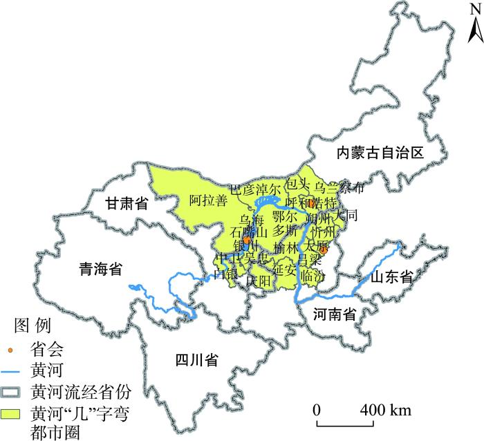
本文以黄河“几”字弯都市圈为研究区,指黄河西起甘肃白银,经宁夏、内蒙古、陕西至山西临汾,处在“几”字型弯顶端的3000 km河段所流经的区域,占地约55.7万km2;黄河“几”字弯都市圈包括太原、呼和浩特、银川3个省会,以及宁夏吴忠、中卫,内蒙古乌海、巴彦淖尔、包头、鄂尔多斯,陕西榆林,山西朔州、忻州、吕梁等共21个行政市(图1)。后文所涉及的城市名均指行政市。
图1
1.2 研究方法与数据来源
1.2.1 流空间分析
针对动态流空间的研究,本文将黄河“几”字弯都市圈包含的21个行政市视为节点,构建了21×21的多值网络矩阵,进一步分析人流、物流、信息流3种流空间在网络矩阵中的特征。人口流动的数据来自于2020年9月22日至2021年1月28日的“百度迁徙地图”(
(1) 网络密度
在社会网络中,用单个节点来表示每个城市。网络密度是指在一个联系网络中各个城市间的联系程度[51]。计算公式如下:
式中:
(2) QAP分析
QAP(quadratic assignment procedure)是研究不同种类网络之间关系的常用方法。它根据数据置换对网络矩阵中每个元素的值进行比较,从而得出矩阵之间的相关系数和回归系数。它还对系数进行了非参数检验,避免了关系数据回归中出现的共线性问题。在本文中,QAP主要用于比较不同种类流空间整体结构的相似性。
(3) 空间结构指数
空间结构指数是Hanssens等[52]在2013年提出的一种改进后的算法。公式如下:
式中:SD为节点间流量的标准偏差值,
(4) 综合流数据处理
为合理表征城市间的综合流,将人流、物流和信息流3种流的矩阵数据进行归一化处理,公式如下:
式中:x是原始数据;Min是矩阵数据的最小值;Max是矩阵数据的最大值;S是归一化的数据。归一化后,S位于0~1的范围内,1表示2个城市的联系最紧密,0表示2个城市的距离最远。将归一化后的数据相加,可以描述城市联系流的强度。
式中:
1.2.2 城市综合实力评价
城市综合实力是评价其等级和核心地位的重要依据。本文从经济、城市建设、科技和吸引力4个维度出发[54⇓-56],选择了9个一级指标、17个二级指标构建了城市综合实力评价指标体系[57-58](表1)。在该指标体系中,分别从经济实力、经济活力与市场规模3个方面衡量城市经济发展水平,其中,用商业银行和上市公司的数量衡量城市的投资环境、营商环境与经济增长潜力,以此来刻画城市经济活力;用城市规模大小与基础设施完备程度来评价城市建设水平;从城市科技投入多寡和科研力量2个方面评价城市科技发展水平,其中以万人拥有高校数量与万人拥有发明专利数衡量城市创新能力与科研力量的强弱,这是由于高校是每个城市的重要科研场所和创新源泉,发明专利数更能直接体现城市的自主创新能力;评价城市吸引力时从社会活力和中心度2个方面进行考虑,以点度中心度和中介中心度相结合来衡量单个城市在都市圈内的核心程度,点度中心度表征城市在网络中的直接联系能力,中介中心度表征的则是间接联系能力。然后运用熵值法对标准化后的指标进行客观赋权,而后根据指标权重计算各城市的综合实力得分。数据来自2020年各级各类统计年鉴,主要包括《中国统计年鉴》《中国人口和就业统计年鉴》《城市建设统计年鉴》,以及各省市统计年鉴等。
表1 城市综合实力评价指标体系
Tab.1
| 目标层 | 一级指标 | 二级指标 | 指标性质 |
|---|---|---|---|
| 经济 | 经济实力 | 人均GDP(元) | + |
| 第三产业占比(%) | + | ||
| 经济活力 | 商业银行数量(个) | + | |
| 上市公司数量(个) | + | ||
| 市场规模 | 全社会固定资产投资(万元) | + | |
| 社会消费品零售总额(万元) | + | ||
| 城市建设 | 城市规模 | 建成区面积(km2) | + |
| 人口总量(万人) | + | ||
| 基础设施 | 人均城市道路面积(m2/人) | + | |
| 建成区供水管道密度(km/km2) | + | ||
| 燃气普及率(%) | + | ||
| 科技 | 科技投入 | R&D经费占GDP比重(%) | + |
| 科研力量 | 万人拥有高校数(所) | + | |
| 万人拥有发明专利数(个) | + | ||
| 吸引力 | 社会活力 | 百度指数 | + |
| 中心度 | 点度中心度 | + | |
| 中介中心度 | + |
1.2.3 多层次空间结构及其算法
根据中心地理论,区域空间相互作用表现出多层次结构(图2)。因此,本文认为区域内存在一个规模等级最高的城市引领着区域发展,即核心城市,其周边各城市与核心城市有密切的社会经济联系。每个城市有各自辐射区域,如此形成多层次区域空间结构。其中,在城市群与都市圈的实际发展情况中,存在许多由双核或多核带动城市群发展的实例,这与本文构建的多层次区域空间结构并不相悖,因为即使是双核或多核结构,其核心城市也是存在相对大小之分的,总是会存在一个相对的核心城市,如成渝城市群是典型的双核城市群,但无论在经济、人口还是城市定位上,重庆都更具区域核心城市的优势。因此,本文基于城市综合实力与城市间的综合流探索区域内网络结构,构建区域空间结构分析算法(图3),通过对21个行政市进行分析计算,得出研究区域的“动—静”结合的多层次空间结构。
图2
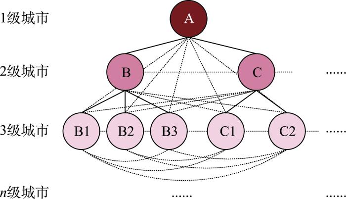
图3
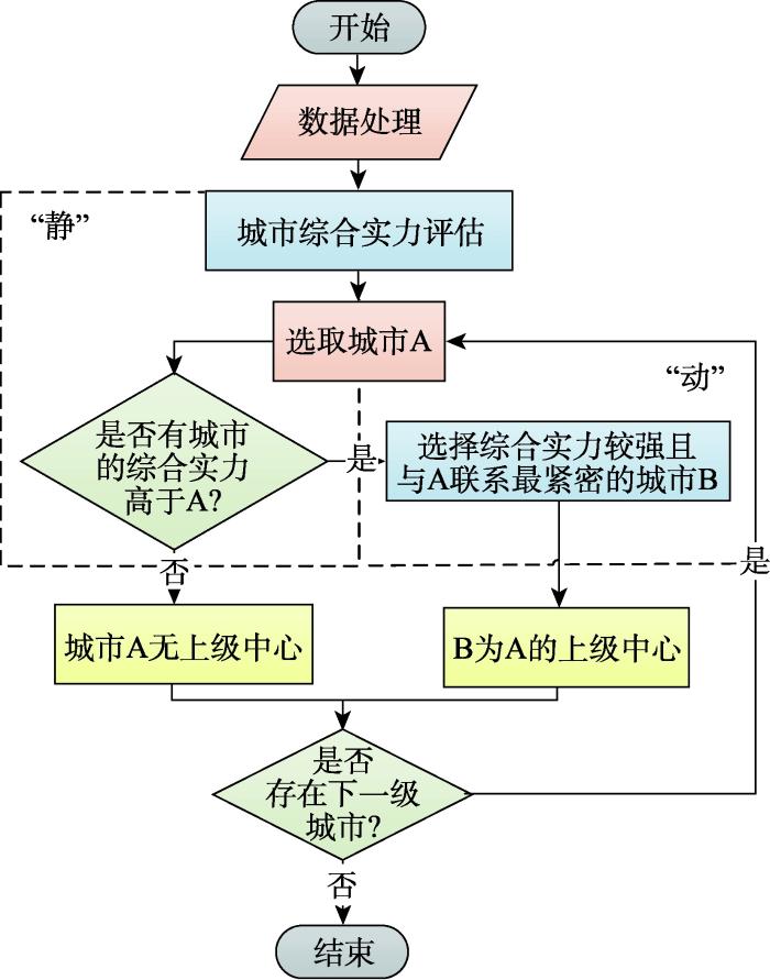
图3
“动—静”结合的区域城市多层次空间格局算法
Fig.3
Calculation algorithm of multi-layered spatial pattern of regional cities using dynamic and static data
区域内各个城市之间均存在着一定的联系,本文通过人流、物流与信息流构建的综合流表征城市间的联系,若与城市B联系最密切的是城市A,且城市A的综合实力强于城市B,则称B在A的辐射区内,称作A吸引B。由此可知,综合实力较强城市的辐射区会由多个城市构成。由此构造了区域多层次空间结构分析算法,具体步骤为:选定任意城市B,通过逐一比较筛选与其相互联系最密切且综合实力更高的城市A,将其拟定为B的上级中心城市(若B的综合实力最高,则称B无上级中心城市);将B弹出堆栈,选择下一城市重复以上过程,直至所有城市比对完毕。
2 结果与分析
2.1 黄河“几”字弯都市圈“动态”要素流空间
2.1.1 城际动态要素流联系强度分析
区域内城际动态要素流网络密度描述了城市网络中行政市(节点)联系的密切程度,密度越高,城市间联系越紧密。其中,黄河“几”字弯都市圈中信息流网络密度最高(0.193),这是由于信息流空间是一个全覆盖的城市网络,两城市间都存在或多或少的信息联系。其次是物流(0.186),这是由于随着消费者个性化需求的增加,中国迎来了线上购物的新高潮,伴随着对物流服务业的要求日益提升,使城市间的物流网络变得日益完善,整体网络密度达到了较高水平,物流服务现已基本覆盖了“几”字弯都市圈所有行政市。人口流的网络密度相对不高(0.113),可能是由于小城市之间和跨省城市之间的人口流动水平较低。其中,在“几”字弯都市圈人口流动数据的观测时间内,百度迁徙规模指数显示91.43%的城市都存在较强的直接的人口联系。个别城市之间人口迁徙指数在指数化处理后趋近于零,代表着人口迁徙数量很小,但不是完全不存在人口联系。
研究区人流分布情况如图4所示。由图可知,一方面,区域内人口省内流动特征显著,强度等级最高的人口流动多发生在同省份城市之间。如鄂尔多斯和乌海、呼和浩特和乌兰察布、大同和朔州、太原和吕梁、银川和吴忠/中卫/石嘴山等城市间的人口流动频繁。这些城市相互之间空间距离近、经济联系密切、交通便利,且二者间作为人口流入区的一方往往是省内中心城市,具有较大的人口规模和市场规模、经济条件较好、生活水平高、工作机会多、在小范围内经济和基础设施辐射能力强,从而拥有较强的人口联系水平。另一方面,省际人口流动往往发生在区域核心城市之间。随着近年来黄河流域生态保护和高质量发展战略的提出,区域内在生态保护和区域协作方面联系不断加深,省际间尤其是区域核心城市间人口流动频繁。太原是山西省省会和重要的经济中心,其经济发展程度高、体量大,人口吸引力强,是区域核心城市,吸纳了较多人口流汇聚至此;呼和浩特和银川人口规模过百万,呼和浩特作为内蒙古自治区首府,其发展具有天然的政治经济优势;银川作为宁夏回族自治区首府,以新材料和高端装备制造业为主导产业,经济条件优越,这些区域核心城市在“几”字弯区域占据着重要的经济地位,也成为人口流动的主要指向。从空间模式上来看,人口流的空间结构趋于多极化,SSI值为0.883,这也印证了鄂尔多斯、银川、太原和呼和浩特等人口流动核心城市都与周边城市存在较强的人口联系。
图4

图4
黄河“几”字弯都市圈人口流空间联系强度
Fig.4
Spatial linkage intensity of population flow in the urban agglomeration of the Yellow River Ji-shaped bend
都市圈物流网络如图5所示。黄河“几”字弯都市圈的物流网络发展已经相对成熟,这与当前中国物流业快速发展的背景相吻合。可以看出,联系程度较高的物流网络都发生在“几”字弯都市圈的东部地区,尤其是山西省内。山西省曾经是中国的煤炭资源大省,拥有极为发达的运输系统,原有的运输系统为物流空间快速发展奠定了基础;另外,山西省位于研究区东部,易受到东部发达地区如北京、天津和石家庄等城市的辐射,带动其物流网络走向成熟;最后,太原属于国家级物流集散地,是华北地区重要的物流枢纽,这也使太原拥有更强大的物流网络。物流的网络空间结构整体上偏向单极化,SSI值为0.135。从空间上来看,物流空间基本上符合极核互动型,即高强度的物流集中在核心城市之间,如银川、鄂尔多斯、太原、呼和浩特和包头。
图5
图5
黄河“几”字弯都市圈物流空间联系强度
Fig.5
Spatial linkage intensity of logistics flow in the urban agglomeration of the Yellow River Ji-shaped bend
信息流网络与物流网络在空间上较为相似,联系强度较高的信息流都集中在区域的中心三角区(图6)。信息流空间已经形成了一个由呼和浩特、鄂尔多斯、银川、榆林、太原组成的完整区域网络,在空间上构成一个“三角形”,引领着都市圈的信息流动。信息流的空间模式趋于多极化,SSI值为0.535,体现了信息网络强大的跨地区和跨层次的联系能力,同时也推动了中心城市之间紧密的协同发展步伐。
图6
图6
黄河“几”字弯都市圈信息流空间联系强度
Fig.6
Spatial linkage intensity of information flow in the urban agglomeration of the Yellow River Ji-shaped bend
2.1.2 城际动态要素流网络相关性分析
通过QAP来分析城际动态要素流之间的关联性(表2),可以看出,信息流与人口流、物流都具有很强的相关性,值分别为0.351、0.544,随着互联网技术的普及,信息流伴随着人口流和物流的流动,往往在以极快、极密集的方式不停地进行传播与交换,使信息流成为一个全覆盖的联系网络,2个城市之间或多或少地都存在着一些信息联系,并与城市间产生的其他要素流粘连性较强。物流与人口流的空间相关性较低,值为0.231,这是由于城市间的物流主要使用公路运输的手段,要素流动形式较为单一,而人流随着技术的提高,逐渐拥有了更为多样的流动方式与流动网络,与物流网络的相似度在不断降低。
表2 黄河“几”字弯都市圈流空间的空间关联性测试结果
Tab.2
| 流空间种类 | 人口流 | 信息流 | 物流 |
|---|---|---|---|
| 人口流 | — | 0.351* | 0.231* |
| 信息流 | 0.351* | — | 0.544* |
| 物流 | 0.231* | 0.544* | — |
注:*表示P <0.001;“—”表示没有数据。
2.2 黄河“几”字弯都市圈“静态”城市综合实力评价
根据1.2.2节构建的城市综合实力评价指标体系,对黄河“几”字弯都市圈内的21个城市的综合实力进行评价(表3)。黄河“几”字弯都市圈各城市综合实力水平呈现出显著的“中心—外围”空间格局,以鄂尔多斯、太原、呼和浩特和银川等行政市为中心。具体来看,区域综合实力最强的城市以鄂尔多斯、太原、呼和浩特、银川、包头为第一梯队,在空间上集中分布在“几”字弯中心区域,这些行政市综合实力得分均超过0.45,其中,呼和浩特、银川、太原均是首府或省会,是黄河“几”字弯区域重要的中心城市,具有天然的政治经济优势,能够汇聚全省全区资源,发展势头强劲,经济辐射范围广。综合实力处于第二梯队的行政市包括榆林、大同、延安,这些城市距区域中心城市空间距离近,受其辐射和带动作用明显,近年来逐渐崛起,城市综合实力分值均在0.25左右,其中大同的工业尤其是清洁能源发展速度快、体量大,综合实力不断增强。其余行政市如宁夏中卫、甘肃白银、内蒙古巴彦淖尔和山西吕梁等行政市处于“几”字弯都市圈的边缘,在地理位置上远离中心城市或经济发达城市,加之交通不便,短期内与上述城市相比仍然实力较弱,是城市综合实力评价分值最低的城市。
表3 黄河“几”字弯都市圈城市综合实力评价结果
Tab.3
| 城市 | 城市综合实力评价得分 | 排名 | 城市 | 城市综合实力评价得分 | 排名 |
|---|---|---|---|---|---|
| 鄂尔多斯 | 0.650 | 1 | 忻州 | 0.202 | 12 |
| 太原 | 0.629 | 2 | 吴忠 | 0.201 | 13 |
| 呼和浩特 | 0.616 | 3 | 乌海 | 0.200 | 14 |
| 银川 | 0.502 | 4 | 朔州 | 0.196 | 15 |
| 包头 | 0.482 | 5 | 乌兰察布 | 0.173 | 16 |
| 榆林 | 0.361 | 6 | 巴彦淖尔 | 0.167 | 17 |
| 延安 | 0.301 | 7 | 吕梁 | 0.155 | 18 |
| 大同 | 0.284 | 8 | 庆阳 | 0.145 | 19 |
| 石嘴山 | 0.233 | 9 | 中卫 | 0.141 | 20 |
| 临汾 | 0.228 | 10 | 白银 | 0.141 | 21 |
| 阿拉善 | 0.208 | 11 |
2.3 “动—静”结合的区域多层次空间格局
图7
图7
黄河“几”字弯都市圈城市多层次城市等级体系
Fig.7
Multi-level city hierarchy in the urban agglomeration of the Yellow River Ji-shaped bend
图8
图8
黄河“几”字弯都市圈多层次空间格局
注:图中带箭头的线由子节点指向父节点。
Fig.8
Multi-level spatial pattern of the urban agglomeration of the Yellow River Ji-shaped bend
在黄河“几”字弯都市圈多层次空间格局中,鄂尔多斯凭借其强大的综合实力、空间优势与吸引力成为了根节点,多数二级城市与其接壤或距离较近,共同构成了最大范围的中心辐射圈。从动态流空间的联系情况来看,鄂尔多斯空间优势明显,在人口流、物流和信息流空间中扮演着中心城市的角色,直接联系与间接联系能力颇强;从静态城市综合实力来看,鄂尔多斯排名第一,经济发达,能源丰富,天然气、稀土、羊毛、煤炭、风电等产业发展成熟,城市建设良好,中介沟通能力强,因此,鄂尔多斯具备黄河“几”字弯都市圈内中心首位城市的条件。鄂尔多斯发挥着中心首位城市的带动作用,呼和浩特、银川、乌海和太原直接被鄂尔多斯所吸引,城市群联系强度呈现以鄂尔多斯为中心,向外呈放射状扩散的形式。
太原、呼和浩特、银川是拥有较大的辐射范围的第二层次城市,拥有以自身为中心的一定范围的辐射区。呼和浩特主要辐射范围为内蒙古自治区境内,主要包括包头、乌兰察布、巴彦淖尔和阿拉善盟。太原主要辐射范围也集中在山西省境内,这可能是由于黄河充当了陕晋的天然省界,对两省联系产生了一定影响。银川也拥有较大的辐射范围,主要由以银川为中心的周边小型欠发达城市构成。由此,黄河“几”字弯都市圈形成了鄂尔多斯、太原、呼和浩特和银川等引领的多层次空间结构。
值得说明的是,乌海城市综合实力并不突出,但仍属于城市等级体系内的第二层次城市,且没有下级城市被其吸引,这是由于乌海和鄂尔多斯之间的人口、经济联系极为紧密,其中不乏受到同省份内部相似的行政、地缘、文化等因素的影响,使其成为了区域内“特殊的”二层次城市。此外,延安和榆林城市实力较为突出,位于第二梯队,但在最终“几”字弯都市圈多层次空间格局中,榆林位于第三层,延安更是位于最后一层,被第三层级的榆林直接吸引。这是由于在判定区域多层次空间格局的算法中,不仅考虑了“静态”的城市综合实力,还综合了“动态”流空间中的城市联系,延安、榆林与核心城市综合联系较弱,使延安成为了“特殊的”四层次城市。
然而,通过研究发现,“几”字弯都市圈没有十分明确的、地位突出的、带动发展的核心城市,这也成为“几”字弯都市圈发展动力不足的主要因素之一。都市圈内明显存在一定的联系壁垒,除一级和二级核心城市外的省际联系受到地形、文化、行政与交通等多方面因素阻碍,亟需畅通联系路径,搭建桥梁,冲破壁垒;另外,还应强调多级联动,培育和发展区域内带动作用明显的核心和重点城市,来作为推动都市圈发展的动力源泉。
3 结论与讨论
本文从“动—静”结合视角入手,“动”关注区域内部的开放性,通过区域内行政市之间的多元要素流空间分析城市之间的关系,主要剖析了人口流、物流、信息流3类动态要素流空间的联系强度;“静”则关注区域内部各城市自身发展,通过各城市自身各方面的发展情况分析评价其综合实力,从4个方面评价和分析了“几”字弯都市圈21个行政市的综合实力表现。最后通过构建区域城市多层次空间格局算法,综合判定黄河“几”字弯都市圈的多层次空间格局,实现“动”与“静”有机结合的创新,既考虑了城市自身的实力情况,又打破了封闭区域系统。主要结论如下:
在黄河“几”字弯都市圈中:① 各类流空间联系强度存在一定差异,其中信息流最强,且与其他流空间的网络相似程度较高,这是由于信息流空间是一个全面覆盖的网络。② 在流空间联系强度方面,各类要素流形成了不同程度的流空间集聚区,但这种集聚受距离影响较为明显;鄂尔多斯居于黄河“几”字弯都市圈流空间中较核心地位,吸引了更多的要素流汇聚于此,其中人口流多发生在省内,物流和信息流网络已达到跨区域沟通水平;呼和浩特、银川、太原在流空间中地位也比较突出。③ 通过对各城市综合实力进行评价并得出排名,位居前三的分别是:鄂尔多斯、太原、呼和浩特;在区域空间格局上,结合综合流联系强度与城市实力明晰了区域内多层次空间格局,黄河“几”字弯都市圈以鄂尔多斯为主导城市,以银川、呼和浩特、太原等为次主导城市,并形成了以这些城市为中心的区域内的小型城市团。
黄河“几”字弯都市圈作为国内“刚出炉”的都市圈,与中国发展历史悠久、势头强劲的城市群与都市圈相比,还存在较大的发展差距。这是由于“几”字弯都市圈不仅面临着地理位置偏远、核心城市发展疲软、经济基础较差等城市群发展中较为常见的问题,还迫切需要解决生态脆弱、人口流失、地区沟通壁垒、产业升级困难等诸多其他城市群没有的问题。因此,黄河“几”字弯都市圈发展需要一个科学定位,能够降低发展成本,发挥都市圈的比较优势,凸显都市圈发展的后发优势,进一步优化发展结构;同时借助国家出台的一系列优惠政策,大跨度整合都市圈发展要素,精确发展方略,采自家之长,探索一条崭新的发展之路。
故此,对于“几”字弯都市圈以及黄河流域城市群的发展举措更需要从当地实际出发,不能照搬其他城市群的成功方案,要考虑到诸多因素对都市圈发展的掣肘。本文从“动”“静”两方面入手,认为“几”字弯都市圈并不能作为一个封闭的区域来研究,而应该以开放的、动态的视角,创新地应对都市圈所面临的复杂情况。而生态脆弱、产业升级、水资源匮乏等问题还未涉及;整个黄河流域城市与城市群的优化协同发展也应在后续研究中加以补充;流空间更是一个极其复杂的系统,很难进行非常充分的模拟。后续的研究应向着多视角、全方位、一盘棋的方向行进,着眼整个黄河流域,结合《纲要》黄河流域生态保护和高质量发展要求,将“一轴两区五极”有机地串联起来,充分考虑生态和环境因素,力求真实刻画“几”字弯都市圈面临的复杂情况,从而提出更有针对性的发展建议。
为了加强黄河“几”字弯都市圈的整体辐射能力和空间联系强度,促进都市圈的协同发展和空间优化,发挥“几”字弯都市圈在黄河流域乃至全国范围内的重要“发展级”作用,落实《纲要》发展目标,根据本文的研究结果,提出以下建议:① 优先重点发展区域核心城市,进一步提高其城市综合实力,最大限度发挥核心城市的带动辐射作用,打造区域发展的“动力源”。黄河“几”字弯都市圈中鄂尔多斯、呼和浩特、太原、银川中有3个省会城市,同时它们都是都市圈中的核心城市,应发挥信息、人才、科技、资金等优势,增强要素集聚,完善科技创新和服务等高端产业功能,成为区域战略核心增长极,从而带动周边地区乃至整个流域发展。② 在大力推进主导城市鄂尔多斯发展的同时,也不能忽略对优势明显的次主导城市的培育,强化具有较大优势的要素流,提升联系较弱要素流的联系能力,为区域网络发展补齐短板,培育都市圈发展新势能,发挥次主导城市对周边城市的辐射和带动作用,增强整体的集聚和辐射能力。③ 要努力打破“几”字弯都市圈结构分散的壁垒,促进要素自由流动,优化资源配置。强化区域内空间联系能力,如区域内边缘位置的庆阳、白银、阿拉善等与其他城市联系较弱的边缘城市,加快以鄂尔多斯、呼和浩特、太原、银川等核心城市为中心的城际交通、信息通信、物流等网络建设,促进区域基础设施的一体化建设,打破小型城市团块间联系壁垒,为城市网络发展提供基础支撑。不断促进要素流动智慧化,以区域核心城市的建设为支点、以基础设施建设为抓手,加快“几”字弯都市圈由“点”到“轴”再到“面”的城市网络进程。④ 要积极探索发展“几”字弯都市圈与中国重大国家战略相衔接的新模式,推动其与中国各城市群协同发展。要积极对接“一带一路”倡议,逐步提升“几”字弯都市圈的对外开放能力,使其成为中国北方对外开放的前沿阵地。
参考文献
中国城市群研究取得的重要进展与未来发展方向
[J].
DOI:10.11821/dlxb201408009
[本文引用: 1]

中国的城市群是近30年来伴随国家新型工业化和新型城镇化发展到较高阶段的必然产物,自21世纪初期城市群成为国家参与全球竞争与国际分工的全新地域单元之后,中国连续10年把城市群提升为推进国家新型城镇化的空间主体,首次召开的中央城镇化工作会议和《国家新型城镇化规划 (2014-2020年)》进一步明确了城市群作为推进国家新型城镇化的主体地位。然而,城市群在中国的研究目前尚处在亟待加强的薄弱环节。系统总结从1934-2013年的80年间发表在地理学报的城市群主题论文,只有不到19篇,仅占总篇数的0.55%,不仅发表篇数少,而且发表时间短,首次发表城市群研究成果不到10年,研究单位和作者群体集中,研究内容瞄准国家需求但比较发散。即便如此,仅有的城市群研究成果还是对国家城市群总体格局的形成起到了引领作用,做出了重要贡献。具体体现在,提出的城市群空间格局推动国家形成了中国城市群空间结构的基本框架,引导国家新型城镇化规划把城市群作为推进新型城镇化的主体形态,提出的城市群空间范围识别标准与技术流程对界定国家城市群范围起到了重要作用,提出的城市群系列研究领域带动城市群的研究向着纵深与实用方向拓展,提出的中国城市群形成发育中存在的问题对未来城市群的选择与发展起到了警示作用。以这些研究进展和成果为基础,未来中国城市群选择与培育的重点方向为:以问题为导向,深刻反思检讨中国城市群选择与发育中暴露出的新问题;以城市群为主体,重点推动形成“5+9+6”的中国城市群空间结构新格局;以城市群为依托,重点推动形成“以轴串群、以群托轴”的国家城镇化新格局;以国家战略需求为导向,继续深化对城市群形成发育中重大科学问题的新认知,包括深入研究城市群高密度集聚的资源环境效应,科学求解城市群高密度集聚的资源环境承载力,创新城市群形成发育的管理体制和政府协调机制,研究建立城市群公共财政制度与公共财政储备机制,研究制定城市群规划编制技术规程与城市群空间范围界定标准等。
Progress and the future direction of research into urban agglomeration in China
DOI:10.11821/dlxb201408009
[本文引用: 1]
Urban agglomeration has been the inevitable result of China's rapid industrialization and urbanization over the last 30 years. Since the early 2000s, urban agglomeration has become the new regional unit participating in international competition and the division of labor. China has declared urban agglomeration the main spatial component of new types of urbanization over the next decade as clarified at the first Central Urbanization Working Conference and in the National New-type Urbanization Plan (2014?2020). However, research on urban agglomeration remains weak and needs to be strengthened. From 1934 to 2013, only 19 papers published in Acta Geographica Sinica contained the theme of urban agglomeration (0.55% of the total number of articles published) and the first paper on urban agglomeration appeared less than 10 years ago. Despite a small number of divergent studies, this work has contributed to and guided the formation of the overall pattern of urban agglomeration in China. For example, spatial analyses have promoted the formation of the fundamental framework of China's urban agglomeration spatial structure and guided the National New-type Urbanization Plan; spatial identification standards and technical processes have played an important role in identifying the scope and extent of urban agglomeration; serial studies have facilitated pragmatic research; and problems with the formation and development of urban agglomeration have provided a warning for future choices and Chinese development. Future research into urban agglomeration in China should (1) review and examine new problems in China's urban agglomeration options and cultivation; (2) critically consider urban agglomeration when promoting the formation of the 5+9+6 spatial pattern; (3) rely on urban agglomeration to construct new urbanization patterns such as 'stringing the agglomerations with the axis, supporting the axis with the agglomerations'; and (4) deepen national awareness about resources, environment effects and environmental carrying capacity in high density urban agglomerations, management and government coordination innovation, the construction of public finance and fiscal reserve mechanisms, the technical regulation of urban agglomeration planning, and standards for identifying the scope and extent of urban agglomeration.
中国城市经济区划分的初步研究
[J].
DOI:10.11821/xb199102001
[本文引用: 1]
本文建立了城市经济区划分的理论与方法——d<sub>△</sub>系和R<sub>d</sub>链法,应用33个指标对全国434个城市进行了综合实力的R型因子分析评价,并进行了不同层次d系的划分和Ⅰ、Ⅱ、Ⅲ级d<sub>△</sub>系和R<sub>d</sub>链组建,提出了我国两大经济发展地带、三条经济开发轴线、九大城市经济区和33个Ⅱ级城市经济区的城市经济区区划体系设想。
A preliminary study on the division of urban economic regions in China
DOI:10.11821/xb199102001
[本文引用: 1]
If a nodel point exist in a nodal region,, there is a link figure through two or more delta-shaped regions.
在黄河流域生态保护和高质量发展座谈会上的讲话
[J].
Speech at the symposium on ecological protection and high-quality development in the Yellow River Basin
中共中央国务院印发《黄河流域生态保护和高质量发展规划纲要》
[J].
The central committee of the CPC and the state council print and issue the outlines for the plan for ecological protection and high-quality development of the Yellow River Basin
高举中国特色社会主义伟大旗帜为全面建设社会主义现代化国家而团结奋斗
[N].
Hold high the great banner of socialism with Chinese characteristics and work together for the comprehensive construction of a modern socialist country
Die zentralen orte in Süddeutschland
[M].
建立中国城市的实体地域概念
[J].
DOI:10.11821/xb199504001
[本文引用: 1]
本文总结了我国在城市的行政地域与景观地域严重背离的情况下,继续使用行政地域区分城乡的种种弊端,认为解决这一问题的关键在于建立适合中国特点又具有国际可比性的城市实体地域概念,以此作为城乡划分及统计的地域基础,文章提出以下限人口规模、非农化水平和人口密度三个指标定义城市实体地域,并在大量实证研究的基础上,通过对中国城市空间形态的分类,提出了一套完整的划分实体地域的方法和工作程序。
Toward establishing the concept of physical urban area in China
DOI:10.11821/xb199504001
[本文引用: 1]
It is generally agreed that human settlements are classified either as urban places or as rural places,In urban studies,one has to deal with the relerant materials in the right way so as to reflect the reality of urban area.Urban areas may be conceived as administrative, functional and physical entities. This paper make a detailed analysis on the various drawbacks of the continued use of adiministrative area in the division of urban and rural area in spite of the serious discrepancies between urban administrative boundaries and the real’ urban space in China, Almost the administrative area of all cities and towns are much larger than the urban built-up area. As a result, vast rural areas and large agricultural population were included in the urban count. Here lies the principal difference with western countries. Obviously, it is difficult if not impossible for us to solve the contradiction by reducing the adiministrative area of a city or town. The authors believe that to solve this problem, it is essential to establish the concept of physical urban area with both adaptability to Chinese conditions and international comparability and make it the basis of urban-rural division and statistics.It is proposed that physical urban area in China can be delimitated in terms of three criteria,prescribed minimum population scale, degree of nonagricuturalization and population density, and the names of citied area or townized area can be given as the counterpart of urbanized area in the United States.The administrative area of a city or town in China consists of two parts: urban district and suburban area. The combination of the two parts is very conplex. For this reason, the key to put our scheme into effect is the classification of types according to the different relations between the two parts.Based on extensive research, the authors find that three factors bring about twelve types. AIa and AIb of them are the most basic types,All these types have their own quantitative standards.After understanding these types, the delineation of the physical urban areas become fairly easy according to the flow diagram(Fig.1).Eleven samples, except one type which is not find,are cited in this paper (Fig.2).
中国区域规划的新特点和发展趋势
[J].
The new characteristics and development trends of China regional planning
克鲁格曼的主要经济地理学观点分析
[J].
A review of Paul Krugmen's economic geography
东北城市间旅游经济联系的空间结构及发展模式
[J].
Spatial structure and spatial development patterns of urban tourism economic connections in Northeast China
云南省旅游经济联系网络结构演化与协同发展模式建构
[J].
The structural evolution of Yunnan tourism economic contact network and the construction of cooperative development model
中国市域空间结构的特征及其影响因素
[J].
DOI:10.13249/j.cnki.sgs.2018.05.004
[本文引用: 1]
优化与重构人口的空间分布格局是当前国家战略决策的重点研究领域之一。首先,利用2000年和2010年人口普查数据,通过帕累托指数、赫芬达尔指数和首位比重指数刻画了中国城市市域空间结构的特征及其演化;其次,从自然地理、社会经济和政府干预3个方面系统地揭示了区域空间结构形成与演化的影响因素。结果表明:① 相对于胡焕庸线以西地区,胡焕庸线以东的市域更偏向多中心;中国市域空间结构相对稳定,有微弱的向多中心发展的趋势;②市域空间结构的形成主要受政府干预影响,自然地理和社会经济的作用相对较弱。具体而言,地表粗糙程度、城市行政等级和政府支出占比会推动区域空间结构朝单中心方向发展;而土地面积、县/县级市内国家级开发区个数、市域内政府间竞争以及人均公路里程则使得空间结构朝均衡的多中心方向演进。
The features and determinants of spatial structure in Chinese prefecture-level city regions
DOI:10.13249/j.cnki.sgs.2018.05.004
[本文引用: 1]
Optimizing the spatial structure of urban population distribution is one of the key strategies in China, and central government has made clear that we should adhere to the coordinated development of large, medium and small cities. At the same time, the income gap that stimulates the flow of population continues to expand, the Hukou system is becoming flexible, and the technologies in transportation, information and communication have been largely improved, which have further promoted the outward flow of the population. Hence, the focus of China’s urbanization should shift from improving the urbanization rate to optimizing spatial efficiency, and it is of great importance to understand the characteristics, evolution and the formation mechanisms of urban spatial structure. Based on the 2000 and 2010 censuses, this paper describes the features of spatial structure in Chinese prefecture-level city regions by three different indexes: Pareto exponent, HHI and Primacy index. It has found that, from the static point of view, city-regions in the southeastern side of Hu line is much more polycentric than the northwestern side ones; and from the view of dynamic process, the spatial structure is rather stable on the whole and has a weak tendency towards polycentricity. Also this paper constructs a comprehensive framework by covering the factors of physical geography, socio-economy and government intervention to systematically examine the influential factors of regional spatial structure. Traditional location theory and economic geography have confirmed the role of physical geography in economic agglomeration and urban formation, and the level of social-economic development and the government have jointly decided the development and evolution of regional spatial structure in China. Our empirical results show, the spatial structure of Chinese city-regions is mainly affected by the role of government intervention, and physical geography and social economic factors on regional spatial structure is relatively limited. Specifically, surface roughness, hierarchy level of cities and government expenditure ratio will bring the regional spatial structure into monocentricity, while administrative land area, the number of NDZs, competition between local governments, and per capita road mileage can make the spatial structure more polycentric. Our previous studies have come to the conclusion that, prefecture cities with a more monocentric spatial structure have a higher labor productivity. Combined with this, the conclusions of this paper have important implications for the future development of new urbanization in China. The finding that urban spatial structure is mainly affected by the visible hand of government might not be a good sign. Government policies are often multi-targets, and its goals, in most cases, are not for the improvement of the spatial structure, but only an additional effect. This also explains why the governmental interventions are often contradictory with each other.
长江中游城市群空间结构演变及效应分析
[J].
Spatial structure evolution and effect analysis of urban agglomeration in middle reaches of Yangtze River
从中心地到城市网络: 中国城镇体系研究的理论转变
[J].
DOI:10.11821/dlyj020180468
[本文引用: 1]
城镇体系核心特征的演变,推动其研究视角由等级制的传统中心地理论向关系制的现代城市网络转变。以已有相关研究成果为基础,简要回顾克氏中心地理论在中国城镇体系研究中的理论和实证进展,通过对中心地理论固有缺陷,以及城镇体系研究逻辑变化的分析,阐明传统中心地理论在解释和解决现代城镇体系问题时的局限性;指出城市网络理论兴起的背景:交通革命带来的时空压缩导致区位论的解释失效、流空间理论的产生、全球化与生产网络的产生、制度与体制演变——中心地组织原则的转化;从企业组织、交通流、信息流三个研究视角,揭示中国城镇体系研究的网络思维端倪;通过研究主体特征的关注由中心性到节点属性、主体关系由等级从属到功能互补、时空尺度由地方到全球三个方面的对比,指出中心地与城市网络应用于城镇体系研究中的理论差异。
From central place to city network: A theoretical change in China's urban system study
DOI:10.11821/dlyj020180468
[本文引用: 1]
The systematic and organizational nature of the urban system is not naturally formed and immutable, but it is actively reconstructed and evolved along with the process of social spatial production. The evolution of the characteristics of the research object has promoted the theoretical development of the urban system research. The research perspective has changed from the hierarchical central traditional theory to the modern urban network of the relational system. Based on the integration of relevant research results, the paper first briefly reviews the theoretical and empirical progress of the Christaller center theory in China's urban system research. By analyzing the inherent defects of the central geography theory and the logical changes in the research of the urban system, the limitations of the traditional central theories in interpreting and solving the problems of the modern urban system are expounded. That is, the main deficiencies of the central theories are owing to closed systems. The hypothesis of spatial homogenization created by theory is too ideal and the perfect structural picture which is devoted to the condition of strict hypothesis is unlikely to exist in reality which leads to the lack of universality in its application and the influence of practical value. Secondly, it is pointed out that the theoretical failure of central land theory and the rise of urban network theory are reflected in the following aspects: the time and space compression brought by the traffic revolution leads to the failure of the interpretation of location theory, the generation of space of flow theory, the generation of globalization and production network, the evolution of system and the transformation of the central organization principle. Thirdly, from the three research perspectives of enterprise organization, infrastructure, and information flow, and the evaluation index system of degree-centrality and cluster structure, etc., the network thinking of China's urban system research is revealed. Finally, it is pointed out that from the level to the network, the differences between the traditional and modern urban system research and the theoretical transformation of China's urban system research are reflected in the main characteristics changing from the central to the node attributes, and the main relationship, from hierarchical subordinate to functional complementary. The analysis logic of the subject relationship is transformed from vertical, monopoly and control of research objects, scale relation to vertical and horizontal, complementary and cooperative, and complex relationship network relations; spatial scales change from the locality to the global; the foothold of the research is from the result of closed and static to the process of open and dynamic.
基于网络社会空间的中国城市网络特征: 以新浪微博为例
[J].
DOI:10.11821/xb201208003
[本文引用: 1]
信息技术影响下的城市区域空间结构变化得到了国内外学者的关注。本文以新浪微博为例, 从网络社会空间的角度入手, 对中国城市网络发展特征进行了研究。研究表明:微博社会空间视角下的中国城市网络存在着明显的等级关系与层级区分, 城市的网络连接度与城市等级表现出了相对一致性。根据城市网络层级与网络联系强度, 东部、中部、西部3 大区域板块的网络联系差异明显, 东部地区内部的联系, 以及东部与中部地区和西部地区的联系几乎构成当前网络体系中的全部。城市网络呈现出分层集聚现象, 具体表现为“三大四小”发展格局, 即京津冀区域、珠三角区域、长三角区域、成渝地区、海西地区、武汉地区、东北地区。高等级城市在整个城市网络中处于绝对支配地位, 北京以突出的优势成为全国性的网络联系中心, 而上海、广州、深圳则成为全国性的网络联系副中心。
China's city network characteristics based on social network space: An empirical analysis of Sina micro-blog
DOI:10.11821/xb201208003
[本文引用: 1]
The change of urban regional spatial structure influenced by information technology has become a hotspot of research at home and abroad. This study tries to analyze China's city network characteristics from the social network space perspective by using Sina microblog as an example. The result shows that China's city network based on the micro-blog social space has a clear hierarchical structure and level distinction. Firstly, the result shows the existence of regional characteristics, performance as a visible regional development pattern which contains "Three Main-regions and Four Sub-regions" according to the analysis of the level distinction in the city network and the connection rate between cities. Specifically speaking, the three main regions contain the Beijing-Tianjin-Hebei region represented by Beijing, Pearl River Delta region represented by Guangzhou and Shenzhen, and the Yangtze River Delta region represented by Shanghai, Hangzhou and Nanjing. The four sub-regions contain Chengdu-Chongqing region, west coast of the Taiwan Straits region represented by Fuzhou and Xiamen, Wuhan region represented by Wuhan and Changsha, Northeast China represented by Shenyang, Harbin and Changchun. Secondly, the result shows there is a significant difference of the network links among Eastern, Central and Western China. Links within Eastern China and the links between Eastern, Central and Western China constitute almost all of the current network systems. It is also found that the high-level cities have an absolute dominance in the city network pattern, and that Beijing is the contact center in China's city network, with an overwhelming advantage. Shanghai, Guangzhou and Shenzhen are the sub-contact centers in the China's city nework.
城市群形成理论建构与实证分析: 产业演进视角
[J].
Theoretical framework and empirical analysis of urban agglomeration formation from the perspective of industrial evolution
基于互联网大数据的区域多层次空间结构分析研究
[J].
DOI:10.3724/SP.J.1047.2016.00719
[本文引用: 1]
大数据逐渐成为各领域学者开展研究的重要途径,目前在人文-经济地理学界逐渐得到重视,并进行了初步应用,相关研究依据尺度不同可以分为居民出行和消费、城市空间结构、区域社会经济联系等。但目前大数据在人文-经济学的应用研究还属起步阶段,少有研究基于大数据对区域多层级空间结构进行系统甄别分析。本文在采集互联网大数据的基础上,结合统计数据、交通路网等传统数据评价城市综合实力、城际联系强度,并基于此构建区域空间结构计算机算法分析区域多层级空间结构。京津冀案例应用揭示了京津冀多层级体系结构,确定了各城市辐射范围、城际相互作用关系。本文初步探索使用互联网大数据甄别区域空间结构,希望能为人文-经济地理领域开展大数据应用研究提供参考。
Identifying the hierarchical regional spatial structure using Internet big data
World city network: A global urban analysis
[M].
“流空间”视角下区域空间结构研究进展
[J].
Research progress of regional spatial structure under the perspective of space of flow
DOI:10.22217/upi URL [本文引用: 1]
The rise of the network society
[M].
Form follows function? Linking morphological and functional polycentricity
[J].
DOI:10.1177/0042098011407095
URL
[本文引用: 1]
Empirical research establishing the costs and benefits that can be associated with polycentric urban systems is often called for but rather thin on the ground. In part, this is due to the persistence of what appear to be two analytically distinct approaches in understanding and measuring polycentricity: a morphological approach centring on nodal features and a functional approach focused on the relations between centres. Informed by the oft-overlooked but rich heritage of urban systems research, this paper presents a general theoretical framework that links both approaches and discusses the way both can be measured and compared in a coherent manner. Using the Netherlands as a test case, it is demonstrated that most regions tend to be more morphologically polycentric than functionally polycentric. The difference is largely explained by the size, external connectivity and degree of self-sufficiency of a region’s principal centre.
Measurement of the world city network
[J].
DOI:10.1080/00420980220080011
URL
[本文引用: 1]
The purpose of this paper is to describe the construction of a set of data that can be used to measure intercity relations. Building on a specification of the world city network as an 'interlocking network' in which business service firms play the crucial role in network formation, information is gathered from global service firms about the size of their presence in a city and about any 'extra-territorial' functions of their offices. This information is converted into data to provide the 'service value' of a city for a firm's provision of its service in a 316 (cities) X 100 (firms) matrix. These data are used to measure the global network connectivity of the cities. In an initial analysis, the paper concludes with a simple correlation exercise that shows New York and London to be `exceptions' rather than 'exemplars' amongst contemporary world cities.
Impact of colored motif characteristics on the survivability of passenger airline networks in China
[J].
基于通信流的吉林省流空间网络格局
[J].
DOI:10.11821/dlxb201404007
[本文引用: 1]
基于实际发生的信息流研究流空间网络格局是一种新的尝试。以吉林省县级以上地方为研究单元,以各地间固定电话通话时长为原始数据,采用主成分分析法、C-Value 和D-Value层级分析法、优势流分析法、最小生成树法对吉林省流空间格局进行了分析。研究表明:吉林省流空间是以长春市为中心,长春市、延吉市、通化市、公主岭市为主导型城市,吉林市、白城市、白山市、辽源市、松原市、四平市为次级主导型城市,其他城市为从属型城市的层级化网络结构;行政区划在流空间格局中发挥基本的影响作用;以长春市为“单中心”的流空间特征明显,吉林省并无明显的次中心作用,长春市与吉林市流空间联系并不紧密,与传统认识和意愿有所不同;公主岭市和敦化市在吉林省流空间格局中占有重要地位,公主岭市倾向于融入长春城市圈,敦化市在吉林省东部空间网络格局中发挥了重要作用,两市的区域联通功能亟待挖掘;四平市和梨树县流空间联系紧密,适宜同城化发展。
Network structure of 'space of flows' in Jilin Province based on telecommunication flows
Mapping world city networks through airline flows: Context, relevance, and problems
[J].DOI:10.1016/j.jtrangeo.2007.12.005 URL [本文引用: 1]
基于国际酒店集团布局的中国城市网络连接度研究
[J].
A city network analysis based on spatial distribution of international hotel groups in China
Transnational exchanges amongst skilled British migrants in Paris
[J].DOI:10.1002/(ISSN)1544-8452 URL [本文引用: 1]
Combining smart card data and household travel survey to analyze jobs-housing relationships in Beijing
[J].DOI:10.1016/j.compenvurbsys.2015.02.005 URL [本文引用: 1]
多重城市网络空间结构及影响因素: 基于有向多值关系视角
[J].
DOI:10.18306/dlkxjz.2018.09.008
[本文引用: 1]
从有向多值关系视角,以中原城市群为案例区,对比分析静态网络、百度信息网络、综合交通网络的空间结构,选择经济、文化、行政、时间距离方面的7个因素构建关系回归模型,剖析3个网络的影响因素。结果表明:①3个网络之间的相关系数表现为:百度信息网络与综合交通网络>百度信息网络与静态网络>综合交通网络与静态网络且其值均高于0.582,表明整体的相似性大于差异性;②在空间结构上,3个网络均表现出以郑州为中心,以京广线和陇海线为发展轴,郑州、开封、新乡、洛阳、许昌构成了骨干网络,并形成辐射与集聚优势共存的中心片区;在中心片区之外,3个网络表现出明显的差异性特征。网络节点的辐射与集聚能力在百度信息与综合交通网络中均是正相关,而在静态网络中则是负相关;③关系回归模型的7个因素均对3个网络产生了不同程度的影响,其中企业合作、行业结构相似、经济制度邻近是影响3个网络相似性较强的因素,而收入差距、文化相似、行政隶属、平均时间距离是影响它们之间差异性的因素。本研究为关系转向下的城市体系研究提供了新的思路。
Spatial structures and influencing factors of multiple urban networks based on the perspective of directed-multivalued relation
DOI:10.18306/dlkxjz.2018.09.008
[本文引用: 1]
Urban system is one of the core subjects of human-economic geography. From the perspective of directed-multivalued relation, taking the Zhongyuan urban agglomeration as the case study area, a comparative study on spatial structures and influencing factors of multiple urban networks—static network, Baidu information network, and comprehensive transportation network—will provide a new train of thought for urban system research under relational transition. This study analyzed the hierarchical structure and the node structure of the networks of the Zhongyuan urban agglomeration, to extract generality and particularity of the three networks mentioned above. Furthermore, we built a relational regression model with the help of the quadratic assignment procedure (QAP) method to dissect the influencing factors of these three networks, from the aspects of economy, culture, administration, and time distance. The empirical results are as follows: (1) The correlation coefficients of the three networks are over 0.582, presented as Baidu information versus comprehensive transportation > Baidu information versus static > Comprehensive transportation versus static, and the overall similarity is stronger than the difference. (2) Integrating the three networks, the Zhongyuan urban agglomeration, a mononuclear spatial structure cored by Zhengzhou, consisted of two regional development belts along with the Beijing-Guangzhou railway and the Lianyungang-Lanzhou railway, and formed a central area with obvious advantages of radiation and concentration with a backbone network constituted by Zhengzhou, Kaifeng, Xinxiang, Luoyang, and Xuchang. Outside of the central area, the three networks showed obvious particularity. The radiation and agglomeration ability of cities have negative correlation in static network, while showed positive correlation in Baidu information network and comprehensive transportation network. (3) The seven influencing factors have different effects on the three networks. Enterprise cooperation, industrial structure similarity, and economic system proximity lead to the similarity of the three networks. Meanwhile, income gap, cultural similarity, administrative affiliation, and average time distance lead to their differences.
基于大数据的流空间研究进展
[J].
DOI:10.18306/dlkxjz.2020.08.013
[本文引用: 1]
流空间是认识城市网络结构和演化的重要手段。近年来大数据的快速发展为流空间研究提供了新的机遇和挑战。论文系统综述了基于大数据的流空间研究进展。首先,论文梳理了基于大数据流空间研究的背景和历史,然后总结了基于大数据的流空间研究的主题、数据类型、方法和主要发现,最后展望了未来的研究挑战。2011年以后,基于大数据的流空间研究呈指数增长趋势,中英文论文年均发表量从2010年的11篇增长到2018年的106篇。大数据主要从提供新的数据源、激发新的分析方法和提供新的研究视角三方面推进了流空间研究。常用于流空间研究的大数据主要包括手机信令数据、社交媒体签到数据、公共交通刷卡数据和出租车轨迹数据,它们比传统统计数据更能直接提供人流、物流和信息流的时空动态信息。研究方法也从传统的基于距离的重力模型发展为网络分析方法。未来在交叉学科研究、大数据和传统数据的耦合、大数据与深度学习和云计算等新方法的结合方面仍需进一步探索,从理论、数据和方法上全面深化流空间研究。
Research progress on the space of flow using big data
DOI:10.18306/dlkxjz.2020.08.013
[本文引用: 1]
The studies on the space of flow play an important role in understanding the structure and change of urban networks. The rapid development of big data provides new opportunities and challenges for the studies on the space of flow in recent years. This article systematically reviewed the research progress on the space of flow based on big data. First, we retrospect the background and history of the studies on the space of flow, then summarized the themes, the types of big data, the methods used for the studies and the major findings, as well as discussed the research challenges. We found an exponential growth of studies on the space of flow using big data after 2011. The annual number of published papers increased from 11 to 106 during 2011-2018. Big data deepen the research on the space of flow by providing new data sources, inspiring new analytical methods, and new research perspectives. Four types of big data—mobile phone, social media, smart card, and taxi trajectory data are commonly used in the studies on the space of flow, which can provide information on spatiotemporal flows (such as population flow, material flow, and information flow) directly. Research methods have also evolved from distance-based gravity models to network analysis. In the future, the research on the space of flow using big data can be further improved by validating the effectiveness and representativeness of the big data, the integration of big data and traditional data, and the information mining from big data using new methods such as deep learning and cloud computing.
基于客运交通流的山东沿海城市带多中心结构特征研究
[J].
Characteristics of polycentricity spatial structure of Shandong coastal city-region based on passenger traffic flow
基于客运交通流的珠三角城市区域功能多中心特征研究
[J].
Characteristics of functional polycentricity of PRD urban region based on passenger traffic flow
流空间视角下的粤港澳大湾区空间网络格局: 基于信息流与交通流的对比分析
[J].
Urban network structure of Guangdong-Hong Kong-Macao Greater Bay Area with the view of space of flows: A comparison between information flow and transportation flow
Comparison of the spaces of call and traffic flows: An empirical study of Qianzhong urban region, China
[J].
Re-shaping global-ness by spending overseas: Analysis of emerging Chinese consumption abroad
[J].
粤港澳大湾区协同创新的综合测度与演化特征
[J].
DOI:10.18306/dlkxjz.2022.09.009
[本文引用: 2]
理解粤港澳大湾区协同创新的网络结构及其演化特征对于新时期大湾区的创新化发展转型至关重要。论文通过构建包括技术创新、知识生产、创新资本3个维度的协同创新测度指标体系,基于城市群流空间网络构建与社会网络分析方法,系统性研究了多创新维度下粤港澳大湾区协同创新的网络结构及其演化特征。结果表明: ① 粤港澳大湾区创新流空间结构呈现出显著的极化特征,且随着时间推移,极化效应不断强化,深圳、香港、广州在创新流空间网络中占据绝对核心地位;② 多维度创新流要素网络结构呈现出显著差异性,技术创新与创新资本维度中,香港、深圳占据了城市群网络的核心,知识生产维度的核心城市则是广州与香港,广州在各维度网络中均扮演了重要的“枢纽型”城市角色,深圳在各维度网络中的创新层级随着时间推移在不断增长;③ 综合多维度指标的测度结果显示,香港与深圳分别是早期与新时期粤港澳大湾区协同创新网络的核心,当前大湾区整体呈现为穗深港三核心并立的城市群网络空间结构。研究可为新时期粤港澳大湾区创新资源的合理化配置提供理论与实证支撑。
Measurement and evolution characteristics of collaborative innovation in the Guangdong-Hong Kong-Macao Greater Bay Area
DOI:10.18306/dlkxjz.2022.09.009
[本文引用: 2]
In the new era of development, understanding the network structure and evolution characteristics of collaborative innovation is crucial for innovation-oriented transformation of the Guangdong-Hong Kong-Macao Greater Bay Area (GBA). This study constructed a collaborative innovation measurement indicator system including three dimensions: Technological innovation, knowledge production, and innovation capital. Based on social network analysis and the construction of "space of flow" network of urban agglomerations, this study systematically examined the network structure and evolution characteristics of collaborative innovation in the GBA from multiple perspectives. The results show that: 1) The spatial structure of innovation flow in the GBA presents an obvious polarization pattern, and it has continued to strengthen over time. Specifically, Shenzhen, Hong Kong, and Guangzhou are at the absolute core of the spatial network of innovation flow. 2) The network structure of multi-dimensional innovation flows show significant differences. With regard to technological innovation and innovation capital, the cores of the network of urban agglomerations are Hong Kong and Shenzhen; in the dimension of knowledge production, the dominant cities are Guangzhou and Hong Kong. In all dimensions, Guangzhou plays an important role as a hub city and Shenzhen's innovation level has continued to grow over time. 3) The measurement of comprehensive multi-dimensional indicators indicates that Hong Kong was the core city of the collaborative innovation network of the GBA in the early stage of development, while Shenzhen has become the core city in the new era. Currently, the GBA as a whole presents a network spatial structure with three cores: Guangzhou, Shenzhen, and Hong Kong. This research can provide theoretical and empirical support for the rational allocation of innovation resources in the GBA in the new era.
Exploring external urban relational processes: Inter-city financial flows complementing global city-regions
[J].DOI:10.1080/00343404.2021.1921136 URL [本文引用: 1]
基于修正引力模型的中国省际旅游者流空间网络结构特征
[J].
DOI:10.11821/dlyj020190021
[本文引用: 1]
高速交通时代旅游者流空间网络结构具有什么特征,是全国旅游流空间组织和管理需要探索的基础问题。贴近客观实际修正引力模型的相关参数,测算中国省际旅游者流,结合复杂网络分析方法,探索空间网络结构的优势、联系和发育水平。分析发现该网络结构稳定,旅游者流大量汇聚于中国的东南半壁、流动不对称、邻近型和跳跃型空间联系结构并存、层级性明显。具体表现为:首先,从优势水平来看,旅游流大量汇聚于上海(东)-广东(南)-四川(西)-河北(北)区域范围内。其次,从联系水平来看,东部三省江苏、浙江、山东是各地优势流量的主要汇聚之所,西藏的排名靠末。最后,从发育水平来看,旅游流动不对称,网络有“紧密团块型”和“飞地跨越型”两种空间联系结构且表现出层级性,不平衡发育状态将在较长时间内保持不变。
Research on structure characteristics of the inter-provincial tourist flow spatial network in China based on the modified gravity model
DOI:10.11821/dlyj020190021
[本文引用: 1]
The characteristics of the spatial network structure of tourist flow in a high-speed transportation era are the fundamental issue that needs to be explored in the spatial organization and management of the national tourist flow. Through modification of relative parameters of the gravity model close to reality to calculate the inter-provincial tourist flow, and with application of the complex network analysis method to measure the superiority, connectivity and development level of the inter-provincial tourist flow spatial network structure in China, the research reveals the following characteristics of the spatial network structure: the structure of the inter-provincial tourist flow spatial network in China is stable, with tourist flows converging in Southeast China, asymmetric flow, coexistent spatial connectivity structures of proximity type and skipping type, and significant hierarchical structure. In practical terms: (1) Seen from the superiority of the inter-provincial tourist flow spatial network in China, main tourist destinations and main target tourism markets are overlapping, the tourism flow largely converges within the region along Shanghai (East)-Guangdong (South)-Sichuan (West)-Hebei (North); (2) Seen from the connectivity level of the inter-provincial tourist flow spatial network in China, three eastern provinces of Jiangsu, Zhejiang and Shandong are main converging places with the superior tourism flow from various regions, among which Jiangsu and Zhejiang even have created a mutually beneficial relationship; while Tibet is at the bottom of the list, especially the flow from Hainan; (3) Seen from the development level of the inter-provincial tourist flow spatial network in China, the entropy is fairly high, and the structure is stable; the tourism flow presents asymmetry at a certain level, and the spatial converge of superior tourism flow is obvious; and there is basically no group-organizing phenomenon within the spatial network; the inter-provincial tourist flow spatial network China has two types of structure, namely “close mass connection structure” and the “enclave spanning connection structure”. The former is represented by Jiangsu, Zhejiang and Shanghai, and the latter by Jiangsu and Guangdong; the inter-provincial tourist flow spatial network in China is of hierarchical nature, roughly presenting a pattern of eastern-central-western gradient weaving; and the status of unbalanced development will remain unchanged for a relatively long time.
中国省际虚拟旅游流网络结构的空间演变特征研究
[J].
DOI:10.18306/dlkxjz.2022.08.001
[本文引用: 1]
虚拟旅游流一定程度上表征了游客需求的地理指向,是分析中国旅游业空间发展格局、推动国内大循环格局形成的重要突破点。论文利用2016—2020年百度指数搜索数据,基于虚拟旅游流流向视角,构建虚拟旅游吸引力与出游潜力指标,结合空间分析工具剖析其空间分布状况;通过虚拟旅游优势度与关联性分析各节点的作用与地位,系统考察虚拟旅游流网络结构的空间演变特征。研究发现:① 从虚拟旅游流空间结构来看,北京、上海及云南为中心地区,三地向外辐射,形成了以京津冀、长三角、云贵川渝地区为核心的虚拟空间结构。② 从虚拟旅游流的极化与扩散效应来看,长三角地区扩散效应显著,而京津冀及其以南地区和云贵川渝地区极化效应显著。其中,京津冀及其以南地区由双核结构转为单核结构;云贵川渝地区内外部联系不断增强,形成了多核心、多层级的强区域内循环结构。③ 基于虚拟旅游流网络结构演变特征分析发现,区域内部循环流动是促进区域内外部旅游均衡发展的有效途径。④ 经济发展水平、旅游资源禀赋、基础设施建设及时空邻近性等是影响虚拟旅游流网络结构演变的重要因素。
Spatial pattern change of the network structure of China's inter-provincial virtual tourism flow
DOI:10.18306/dlkxjz.2022.08.001
[本文引用: 1]
Virtual tourism flow (VTF) to some extent represents geographic biases of tourist demands. It is a crucial entry point for analyzing the spatial structure of China's tourism and promoting the formation of domestic circulation. From the perspective of VTF, this study built models of virtual tourism attraction and latent emissiveness using Baidu index search data from 2016 to 2020. Coefficient of variation and spatial autocorrelation were employed to analyze its spatial distribution characteristics. Virtual tourism dominance degree and correlation of each provincial node were analyzed to further investigate the characteristics of the spatial change of VTF network structure. The results show that: 1) Beijing, Shanghai, and Yunnan are the radiating centers in the spatial structure of China's VTF. Based on this, a virtual spatial structure with the core of the Beijing-Tianjin-Hebei region, the Yangtze River Delta region, and the Yunnan-Guizhou-Sichuan-Chongqing region is formed. 2) The polarization and diffusion features of VTF are manifested in the obvious diffusion effect of the Yangtze River Delta, and the significant polarization effect of the Beijing-Tianjin-Hebei region and areas to its south and the Yunnan-Guizhou-Sichuan-Chongqing region. Among them, the Beijing-Tianjin-Hebei region and areas to its south has changed from a dual core to a single core structure, while the Yunnan-Guizhou-Sichuan-Chongqing region has formed a robust regional circulation structure with multiple cores and multiple levels due to the region's continuously strengthened internal and external ties. 3) According to the spatial change of VTF network structure, intra-regional circulation is an effective way to balance the development of tourism within and outside a region. Meanwhile, provinces with strong virtual tourism advantage degree have stronger resilience, which can well boost the circulation of inter-regional tourism flow. 4) The change of VTF network structure is mainly affected by economic development level, tourism resource endowment, infrastructure development, and temporal and spatial proximity. This study broadens the horizon of tourism flow research by introducing the concept of VTF and analyzing both virtual tourism attraction and latent emissiveness. Its results provide a reference for the geographic direction of tourist demands, which can help to promote the coordinated regional development of tourism.
中国入境旅游城市合作网络时空格局及驱动因素
[J].
DOI:10.11821/dlxb202208013
[本文引用: 1]
基于1997—2017年中国60个城市入境旅游经济发展数据,辅以修正的引力模型和社会网络分析方法,系统分析了中国入境旅游城市合作网络时空格局,并借助二次指派程序方法对合作网络演变的驱动因素进行探讨。结果表明:① 中国60个入境旅游城市合作网络强度逐渐增强,国家层面合作网络结构逐渐显现,合作强度前5名的分别为广州—深圳、北京—上海、北京—天津、上海—苏州和上海—深圳。② 整体网络特征上,网络密度逐渐增加,整体网络通达度在提升,城市“领导者”地位在下降,网络整体均衡性在提升,且中国东、中、西三大地区间差异显著,东部地区城市合作最紧密,西部地区城市次之,中部地区城市紧密度最小。③ 个体网络特征上,将中国入境旅游城市分为外向型、内聚型、均衡发展型和孤立型4类,且权力角色上呈核心领导者、次核心领导者、一般合作者和边缘合作者的“核心—边缘”分布格局。④ 地理空间邻近性、旅游资源差异、旅游接待能力差异、城市规模等级和旅游交通情况的相近性对网络提升具有显著影响,对外经济贸易差异对中、西部地区城市旅游合作的影响是正向的,而对整体网络和东部网络的影响是负向的。
Spatio-temporal pattern and influencing factors of cooperation network of China's inbound tourism cities
DOI:10.11821/dlxb202208013
[本文引用: 1]
The high-quality development of inbound tourism is an important foundation for the high-quality development of China's tourism industry, and its inbound tourism city cooperation network has become a key support to achieving this goal. However, our current knowledge of the spatio-temporal characteristics of China's urban cooperation network of inbound tourism remains limited. This paper used economic development data of inbound tourism in 60 cities of China from 1997 to 2017, the revised gravity model, and social network analysis method. It first examines the intensity of China's inbound tourist city cooperation, and then systematically analyzes the spatiotemporal patterns of these networks. Finally, it applies the second assignment method to discuss the possible driving forces of these networks. The results show that: (1) These networks across the 60 cities have gradually increased in intensity. Simultaneously, a national-level network of tourism cooperation has emerged. The top five pairs of city groups participating in tourism cooperation are Guangzhou-Shenzhen, Beijing-Shanghai, Beijing-Tianjin, Shanghai-Suzhou, and Shanghai-Shenzhen. (2) With regard to overall network characteristics, network density is gradually increasing, overall network accessibility is improving, city "leader" status is declining, and the overall network balance is strengthening. There are significant differences between China's three major parts (eastern, central, and western regions): cities in the eastern region have the strongest cooperation, followed by cities in the central and western regions. (3) In terms of individual network characteristics, China's inbound tourist cities are divided into four categories: extroverted, cohesive, balanced, and isolated. Their power roles demonstrate a "core-periphery" pattern, showing the characteristics of core leaders, sub-core leaders, general collaborators, and marginal collaborators. (4) Geographical proximity, differences in tourism resources and reception capabilities, city-scale levels, and similarities in tourism-traffic conditions have a significant effect on the improvement of the network. Differences in foreign economic engagement and trade have a positive effect on urban-tourism cooperation in the central and western regions. However, these differences have a negative impact on eastern networks and the whole country. Our findings unravel the changes in China's inbound tourist city cooperation networks, and provide important reference for the optimization of the network.
Temporary population mobilities between Estonia and Finland based on mobile phone data and the emergence of a cross-border region
[J].DOI:10.1080/09654313.2020.1774514 URL [本文引用: 1]
多尺度流空间视角下的超大城市对外协同治理研究: 以北京为例
[J].
Research on external collaborative governance of megacities from the perspective of multi-scale flow space: A case study of Beijing City
流动性视角下的国土空间安全及规划应对策略
[J].
DOI:10.31497/zrzyxb.20220801
[本文引用: 1]
人员、物资、能源资源等要素在不同层级空间的频繁流动,持续重构人类活动与自然环境关系,并对国土空间安全产生影响。从流动性视角进行国土空间安全探讨,提出在活动承载安全、资源与生态安全基础上,应考虑要素流动与人类活动、资源环境的耦合性及其潜在风险。流动性与国土空间安全的关系可以从“流”空间与场所空间耦合、“供—流—需”协调与资源配置安全、要素流与国土空间系统韧性三个方面来表征。以生态、水、粮食、经济、社会等安全塑造为目标,立足于各类要素流对人地关系系统影响的不确定性,以及自然灾害、突发公共安全事件等极端条件下的流动性风险,通过合理引导资源配置、科学布局国土空间要素等手段,实现人类活动、自然环境系统之间的自适应与良性反馈调节,形成安全韧性的国土空间格局与框架。在国土空间规划中,需要进行要素流与国土空间开发保护的耦合协调性分析评价,建立“形”与“流”结合的国土空间结构优化分析方法,增强不同空间的功能弹性以适应要素流动和活动集聚的不确定性,建立供需协同的国土空间支撑体系。研究对提升国土空间可持续发展水平以及保障人类生存安全具有重要意义。
Territory spatial security and planning strategies from the perspective of mobility
DOI:10.31497/zrzyxb.20220801
[本文引用: 1]
Security is an important aspect for sustainable development of territorial space. It is also a crucial issue in planning, implementing, and supervision of territorial space. With the rapid development of urbanization and industrialization, people, goods, energy, resources and other factors flow more frequently in different regions, between urban and rural areas, and within urban spaces. The coupling relationships between human activities and natural resources have become more and more unstable, which exacerbates the risk of human survival. It is urgent to establish the territory spatial security framework faced with the uncertainty of human activity and elemental flows. This paper explores the security of territorial space from the perspective of mobility. On the basis of the safety of activities in different spaces and the safety of resources and ecology, we should consider the coupling of elemental flows, human activities, and resources and environment, as well as potential risks. The relationships between mobility and territory spatial security can be characterized from three aspects: the coupling of space of flows and space of places, the coordination among resource supply-flow-demand and the reconfiguration of resource, and elemental flows and the resilience of the territory spatial system. Towards safety goals of ecology, water, food, economy, society, and other elements, it is crucial to explore the uncertain impacts of various elemental flows on the man-land system and the mobility risks under extreme conditions such as natural disasters and sudden public safety incidents. It is also important to lead the self-adaptation and benign feedback adjustment between human activities and natural environmental systems through optimizing resource allocation and territory spatial layout. Thus, we proposed a framework of territory spatial security. In territory spatial planning, it is necessary to carry out the coupling coordination analysis with elemental flows and territorial spatial development and protection, to establish new analysis methods of territory spatial structure combining spatial forms and flows, and to enhance the functional flexibility of different spaces to adapt to the uncertainty of elemental flows and activity agglomeration, as well as to construct territory spatial supporting systems that synergize supply and demand. This study is of great significance for improving the sustainable development of territorial space and ensuring the safety of human survival.
城乡融合评价研究综述: 内涵辨识、理论认知与体系重构
[J].
DOI:10.31497/zrzyxb.20211013
[本文引用: 1]
科学的城乡融合评价是城乡融合工作的重要环节,是建立健全城乡融合体制机制的基础。以“内涵辨识—理论认知—体系重构”为逻辑主线,从城乡融合的概念内涵、基础理论、评价指标、评价方法、评价尺度及演化机理等方面,开展城乡融合评价综述。研究表明:学界对城乡融合概念与内涵的认识基本一致,且已有一定理论基础;城乡融合评价指标选取呈现多维化、多属性化特征,但指标体系构建尚未突破静态性层面;定量评价方法较为单一;研究尺度整体偏向中宏观,缺少微观视角下的量化以及不同融合模式对比研究;城乡融合的时空分异格局及其机理研究亟待进一步深化。对此,提出了以下五点展望:(1)加强基础理论体系建设,完善系统研究框架构建;(2)优化多维评价指标体系,识别城乡融合发展模式;(3)深化城乡要素流动机制,推动城乡空间均衡发展;(4)加强微观尺度细节挖掘,健全城乡融合推进机制;(5)强化数字经济赋能作用,创新城乡高质量融合发展机制。
Review of urban-rural integration evaluation: Connotation identification, theoretical analysis, and system reconstruction
DOI:10.31497/zrzyxb.20211013
[本文引用: 1]
The scientific evaluation of urban-rural integration is the core content of urban-rural integration, and it is the foundation for establishing and improving the institutional mechanism of urban-rural integration. Based on the logical line of "connotation identification-theoretical analysis-system reconstruction", this paper carries out the review of urban-rural integration evaluation including concept connotation, theoretical basis, evaluation index, evaluation method, evaluation scale, spatio-temporal differentiation, and mechanism analysis. At present, the academic understanding of the connotation of urban-rural integration is basically the same. The evaluation index selection of urban-rural integration shows multidimensional and multi-attribute characteristics, but the index system construction has not broken through the static characteristics. Quantitative evaluation method is relatively simple. Generally, current research still remains at the macro scale, but lacks quantitative research from a micro perspective and comparative studies of different fusion modes. The spatial and temporal differentiation pattern and its mechanism of urban-rural integration need to be further deepened. Finally, this paper puts forward five prospects: (1) strengthening the construction of basic theory system and perfecting system research framework; (2) optimizing the multidimensional evaluation index system and identifying the development model of urban-rural integration; (3) deepening the flow mechanism of urban and rural elements and promoting the balanced development of urban and rural space; (4) strengthening the exploration of micro-scale details and improving the promoting mechanism of urban-rural integration; (5) strengthening the empowering role of the digital economy and innovating the development mechanism of high-quality urban-rural integration.
“流空间”视域下淮海经济区城乡融合发展驱动机制
[J].
DOI:10.31497/zrzyxb.20200810
[本文引用: 1]
从要素流动多维重构淮海经济区城乡融合评价体系,以动态耦合协调度模型测度城乡融合水平并分析其时空分异规律,最后从“流空间”视角探索城乡融合发展驱动机制。结果表明:(1)研究区城乡融合水平整体较低但趋势向好,其正向空间关联和局域内向集聚特征明显。(2)流空间视角下区域呈多中心网络结构,且在人流和资金流下相对紧密,而物流和信息流下“核—辐”结构突出。(3)推动核心区集聚效应转向扩散效应,发挥各城市节点比较优势,合理调节要素流动强度、方向和质量,并在实施地方和国家政策时配套相关制度,方能实现淮海经济区城乡融合“量”“质”同升。
Driving mechanism of urban-rural integration in Huaihai Economic Zone: Based on the space of flow
DOI:10.31497/zrzyxb.20200810
[本文引用: 1]
To restructure the evaluation index system of urban and rural integration from population, space, economy, society and ecological environment, the dynamic coupling coordination model was selected to measure the urban and rural multi-dimensional integration level, and the global Moran index and the local indicators of spatial association (LISA) were used to reveal the spatial distribution characteristics of the urban-rural multi-dimensional integration level in Huaihai Economic Zone. And then, the spatial correlation pattern in the study area was analyzed by the spatial structure index (SSI) from the population flow, logistics flow, capital flow and information flow. And finally, the driving mechanisms of urban-rural integration in the study area were explored by the fixed effect spatial error model (SEM-FE) from the perspective of these four types of flow. The results are as follows: (1) The urban-rural multi-dimensional integration levels are low but go well, the overall level in the research area rose from 0.016 in 2003 to 0.028 in 2017, with an annual rate of 0.08%. When the urban-rural multidimensional integration structure maintains stable in the research period, the economic integration is the highest, while the spatial integration is the lowest. (2) The regional interrelation is close in the context of population flow and capital flow, while it shows a "core-periphery" structure under the material flow and information flow. In general, the spatial structure in Huaihai Economic Zone is a decentralized network with multiple central cities, which lays a good foundation for the future development of urban-rural integration and inter-regional coordinated development. (3) In order to achieve the improvement of quantity and quality of urban-rural integration in Huaihai Economic Zone, we should shift the effect of the core area from agglomeration to diffusion, and need reasonable labor distribution and trading to stimulate the regional comparative advantage fully of each city node. Moreover, it is necessary to assist a series of cultural, economic and political systems in the implementation of local and national policies, because urban and rural integration development is a big cycle system of the socio-economy.
Analyzing urban development patterns based on the flow analysis method
[J].
DOI:10.1016/j.cities.2018.09.015
[本文引用: 1]
Analyzing patterns of urban development should consider the network structure among cities as well as the formation of the function and role of each city in the network. The flow analysis of various factors between cities is based on urban network and space of flow theories. This study used Hebei Province of China as the case. The comprehensive status of each city in the regional urban network was measured by simulating the economic, information, traffic, and financial flow among cities. Results indicate that the development pattern can be divided into three levels with a multi-core and multi-node network structure. In addition, the flow analysis method can predict 67% of urban developmental level. Furthermore, some policy recommendations are put forward to facilitate regional integrated development in Hebei province.
产业集聚与城镇空间格局的耦合关系及时空演化: 以长三角区域为例
[J].
DOI:10.11821/dlyj020180985
[本文引用: 1]
产业集聚与城镇空间格局的变动之间存在着密切的联系。针对两者之间的耦合关系及时空演化问题,构建区域产业集聚与城镇空间格局演化综合评价指标,并利用1990—2016年长三角区域16个城市的统计数据,基于面板回归模型和空间重心模型探究两系统之间演化的互动作用关系和时空演化。结果表明:长三角区域的产业集聚与城镇空间格局间存在较显著的耦合关系;长三角区域各市区的耦合协调度及空间匹配度均稳步提升,但长三角区域耦合协调发展程度不够均衡,长三角南部的耦合协调的发展程度稍弱于长三角区域北部的发展;在近几十年的发展中,长三角北部地区逐渐形成以上海-南京为轴线的耦合协调发展区域,整个长三角区域的耦合协调则呈现“Z”字形特征。
Research on the coupling relationship and spatial-temporal evolution between industrial agglomeration and urban spatial pattern: A case study of the Yangtze River Delta
DOI:10.11821/dlyj020180985
[本文引用: 1]
There is a close relationship between industrial agglomeration and changes in urban spatial patterns. This article is aimed at the coupling relationship between regional industrial agglomeration and urban spatial pattern, so as to construct comprehensive evaluation indicators of regional industrial agglomeration and urban spatial pattern evolution, and explore the interaction and spatial-temporal evolution between the two systems through the panel regression model and spatial center of gravity model by using statistics from 16 cities in the Yangtze River Delta region from 1990 to 2016. The results show that there is a significant coupling relationship between industrial agglomeration and urban spatial pattern in the study area. Coordination degree and spatial matching degree of various urban areas in the Yangtze River Delta region are steadily increasing. However, the degree of coupling and coordinated development in this region is not balanced enough. The degree of coupling and coordination in the southern part of the Yangtze River Delta is slightly weaker than that in the northern part. In the development of recent decades, the northern part of the delta gradually formed a coupling and coordinated development area with Shanghai-Nanjing as the axis, and the coupling coordination of the entire Yangtze River Delta region is characterized by a "Z" shape.
中国三大城市群集聚空间结构演化与地区经济增长
[J].
Evolution of agglomeration and its spatial structure with economic growth in three major metropolitan regions of China
城市群创新网络的空间演化与组织: 以京津冀城市群为例
[J].
Spatial evolution and organization of urban agglomeration innovation network: A case study of Beijing-Tianjin-Hebei urban agglomeration
Assessing the functional polycentricity of the mega-city-region of central Belgium based on advanced producer service transaction Links
[J].DOI:10.1080/00343404.2012.759650 URL [本文引用: 1]
基于流空间视角的城市群空间结构研究: 以珠三角城市群为例
[J].
DOI:10.11821/dlyj020180635
[本文引用: 1]
随着现代交通、通信以及信息技术的发展,基于网络社会的“流空间”成为研究城市群空间结构的重要理论前沿。借助珠三角城市群9个城市的人流、物流、资金流和信息流数据,对珠三角城市群空间结构的现状和发展趋势进行综合性判断。研究发现:① 珠三角城市群的空间结构现状在“点-线-网-面域”4个层面均呈现出明显单极化态势,广州市是“流空间”视角下珠三角城市群的核心,区域网络结构呈现出“缺位型金字塔形结构”;② 珠三角城市群网络的未来发展中位于不同层级的城市将起着不同的作用,其中广州、深圳、东莞等城市对空间结构发展起着导向性作用,而佛山、中山等城市将承担着联系中转站功能;③ 珠三角各城市的流度辐射区一体化明显,各城市辐射影响区的空间形态也表明了各城市的功能圈和势力范围。未来随着全球化趋势和区域一体化政策的加强,珠三角城市群的集聚效应将不断转化为扩散效应,将极大提升珠三角城市群对全球范围内资源的吸聚和配置能力,助力珠三角城市群走向网络化的发展时代。
Spatial structure of the urban agglomeration based on space of flows: The study of the Pearl River Delta
DOI:10.11821/dlyj020180635
[本文引用: 1]
With the development of modern transportation, communication and information technology, the "space of flow" based on network society has become an important theoretical frontier for studying urban spatial structure. Based on the passenger flow, material flow, fund flow and internet information flow in nine cities of the Pearl River Delta, this paper makes a comprehensive judgment on the present situation and development trend of spatial structure of urban agglomeration in this region. Research findings are as follows: (1) The present situation of urban spatial structure in the Pearl River Delta presents obvious unipolarization, and Guangzhou is the core of the delta based on the "space of flow". (2) Cities at different levels will play different roles in the future development of the urban agglomeration network. Guangzhou, Shenzhen and Dongguan play a leading role in the development of spatial structure, while Foshan, Zhongshan and other cities will assume the function of connecting transit stations. (3) The urban areas of the Pearl River Delta are well integrated. The spatial form of the radiated area of each city also indicates the functional circle and sphere of influence of each city. In the future, with the strengthening of globalization and regional integration policies, the agglomeration effect of the Pearl River Delta region will be transformed into diffusion effect, which will greatly improve the ability of the delta to absorb and allocate resources on a global scale.
省域城市网络中心性测度及比较研究: 以江苏省和广东省的对比分析为例
[J].
Measurement and comparison research of provincial urban network centrality: Taking comparative analysis of Jiangsu and Guangdong as example
基于网络空间结构的长江经济带城市影响区划定
[J].
Influence scope of Yangtze River Belt based on the urban spatial structure
多维消费流视角的海峡西岸经济区城市网络结构
[J].
Urban network structure of the western Taiwan Straits economic zone based on multi-dimensional consumption flow
可持续城市多尺度评价框架及指标体系的研究进展与展望
[J].
Research progress and prospects for multiscale assessment framework and indicator system for sustainable cities
