

作为重要的国际合作平台和国际公共产品,“一带一路”倡议国际合作取得了丰硕成果,学术界也一直在相关领域深耕细作、推动“一带一路”高质量发展[1-2]。早期,学者们主要着眼于“一带一路”倡议解读和内涵挖掘[3-4]。随后,“一带一路”倡议的地缘政治影响[5]、交通基础设施[6]、对外直接投资[7]、贸易格局[8-9]等研究议题受到广泛关注。作为“一带一路”创新合作模式,政策沟通、设施联通、贸易畅通、资金融通和民心相通不仅是“一带一路”建设的合作重点,也是“一带一路”包容性发展和行稳致远的关键所在[10]。其中,贸易畅通是共建“一带一路”的重要内容和核心环节,直接关系到“一带一路”建设的实际成效。因此,开展“一带一路”贸易连通性研究,探究“一带一路”贸易网络的结构性特征与演化过程,对于有效推进“一带一路”经贸合作、实现高质量发展具有重要意义。
在过去半个多世纪,国际贸易快速发展,商品和服务贸易在世界范围内的流动塑造出新的国际劳动分工体系[11],贸易的全球化逐步成为经济全球化最为标志性特征之一[12]。近年来,随着中美贸易战、新冠疫情和俄乌冲突等重大事件影响,国际贸易形势正在经历结构性变化过程,贸易合作在全球化和区域化之间交织碰撞,国际贸易格局日趋复杂化和多样化[13-14]。尽管受到国际形势等综合影响,国际贸易发展的需求、趋势和活力依然保持弹性,并呈现出全球尺度的区域分化。在传统国际贸易理论中,如绝对优势、比较优势和要素禀赋等理论,主要沿着古典经济学中“生产—流通—消费”等环节视角,探究不同分工模式对国际贸易带来的影响和机制[15⇓-17]。长期以来,经济地理学对国际贸易研究相对零散,主要侧重于国际贸易地理结构的描述[12,18-19]。而随着全球价值链深入发展,国际贸易趋向网络化发展,最终构成了世界贸易网络体系。国家与国家间在空间上形成的相互联系的贸易流,交织构成了国际贸易网络结构。在此背景下,贸易网络研究逐步成为透视国际贸易体系的重要路径。当前,针对贸易网络的研究大体可以分为3类。第一类,从网络宏观特征出发,学者们利用网络密度、集聚系数、平均最短路径等指标对网络拓扑结构进行刻画和分析[20],研究发现,世界贸易网络同样具有小世界特性[21]、幂律分布[22]、社区结构[23]等典型的复杂网络特征。第二类,从网络微观尺度出发,部分研究侧重于运用网络中心性等指标,考察贸易网络中不同国家在网络中的地位或角色变化,分析网络的等级结构特征[24-25]。第三类,聚焦于网络中观尺度特征,学者们利用社区发现[26-27]、核心—边缘结构[28]、块模型[29]等分析方法,探究贸易网络的结构特征及其与整体贸易网络的嵌套关系。总体上,当前国际贸易网络研究取得了明显进展,有力深化了关于国际贸易网络发展的科学认知。特别是当前网络分析方法发展迅猛,为各领域提供了大量具有洞察力的网络分析手段,被越来越多地应用到国际贸易等研究领域中,并展现出明显的学科交叉特性。
随着“一带一路”倡议深入发展,学术界对“一带一路”贸易网络研究也逐渐升温,越来越多的学者借助网络分析方法探究“一带一路”沿线国家间贸易联系构成的复杂网络。邹嘉龄等[30]利用社会网络分析方法刻画了“一带一路”沿线国家贸易网络基本特征与组团结构,并进一步分析了中国等区域贸易网络的“核心—边缘”结构。为探究不同产品在“一带一路”贸易网络结构特征和影响因素,部分学者对能源[31]、农产品[32]、技术[33]等分行业贸易网络展开了相关研究。其中,宋周莺等[34]基于社区发现算法,对“一带一路”贸易网络与全球贸易网络的拓扑特征进行了分析,发现“一带一路”区域联系强度具有差异性。李优树等[35]从产业链视角分别构建了4类“一带一路”沿线国家石油产业链贸易网络,得出该贸易网络整体密度逐渐增大,贸易联系愈加紧密,且具有“小世界性”特征的结论。杨文龙等[21]借用引力模型对“一带一路”贸易网络进行了解读,发现贸易往来与地缘距离息息相关,并试图从科技、语言、制度和文化4个方面进一步分析了地缘因素在贸易网络中的影响力。上述研究通过运用不同网络分析方法,从不同视角对“一带一路”贸易网络的空间格局、产品结构、拓扑特征和地缘影响等方面开展了相关研究,深化了学术界对于“一带一路”贸易网络的整体认知。
作为网络科学领域的前沿话题,中尺度结构提供了一种透视网络中内蕴结构的独特视角,对于科学理解和认识网络结构连通性具有重要意义。然而,目前从中尺度视角研究“一带一路”贸易网络拓扑关系及其结构性演化的研究相对较少,“一带一路”贸易网络连通性变化及其空间影响有待于进一步揭示。因此,基于长时序“一带一路”贸易网络数据库,本文综合集成组团识别、核心—边缘轮廓、视差滤波等网络中尺度分析方法,构建探索贸易网络连通性的分析框架,从节点、连边2个维度揭示“一带一路”贸易网络的时空格局、拓扑关系以及结构性演化,以期能为新时期“一带一路”框架下优化贸易发展格局、提升产业链供应链稳定性提供科学参考。
1 研究区域、数据与方法
1.1 研究区域与数据处理
作为全球最大和最权威的国际贸易数据资源平台,联合国商品贸易统计数据库涵盖了全球200多个国家和地区的国际商品贸易数据。基于该数据库,本文获取了“一带一路”沿线65个国家间的商品贸易流量数据,包括报关国、伙伴国、贸易额、方向等属性。由于各国对进口贸易的监管相较于出口贸易更为严格,本文均使用进口口径采集贸易数据;通过数据整理和转换,最终构建“一带一路”沿线65个国家间的贸易流量矩阵,即“一带一路”贸易网络。同时,本文限定研究期限为2001—2020年。其中,2001年中国加入世界贸易组织,极大地改变了世界贸易格局;2008年全球金融危机爆发,随后全球经济发展进入了低潮期;2013年中国提出了“一带一路”倡议,深刻影响着全球经贸发展格局和国际劳动分工体系。基于上述考虑,本文选择2001、2008、2013和2020年4个具有代表性的年份作为研究截面,以此呈现“一带一路”贸易网络发展的重要转折和演化过程。
1.2 研究方法
1.2.1 组团识别
具体地,Leiden算法是通过迭代运算收敛到一个分组,其中所有组团的所有子集都保证是局部最优分配的。假定
在该算法中,所有社区的γ-separation(分割性)和γ-connectivity(连通性)这2个属性在每次迭代中均得到优化。
1.2.2 核心—边缘轮廓
在一个具有理想核心—边缘结构的网络中,边缘节点通常只与核心节点相连接,而边缘节点之间却不存在连接。然而,在大多数真实网络中,核心—边缘结构并不总是理想形式的,即边缘节点之间也会有微弱联系(而不是绝对没有)。因此,需要对边缘节点的持续概率做一般化定义,即最大子网络S的持续概率
基于上述对持续概率
式中:
作为上述算法的副产品,集中系数(centralization coefficient)和核心度(coreness)成为认识网络核心—边缘结构的重要工具。在核心—边缘结构中,集中系数主要反映的是网络结构的集中程度,核心节点分布越集中、数量越少,则该网络的集中系数越大。因此,集中系数C的表达式为:
当C=1时,网络只有单独一个节点;当C=0时,则网络为完全均衡分布。核心度越接近于1,则表示该节点在网络中的位置和角色越重要;反之,则该节点越边缘化。
1.2.3 视差滤波
与组团结构、核心—边缘结构类似,骨干结构也是网络中一种重要的中尺度结构。在网络中,骨干结构是一个稀疏的、(未)加权的子图,只包含该网络中最“重要”或“显著”的一些连边。当原始网络过于密集或连边权重难以解释时,提取网络的骨干结构对于理解网络结构非常有效。其中,视差滤波算法利用局部异质性和局部相关性,能够在具有强无序性的加权网络中过滤出优势连接的骨干结构,并保留所有尺度上的结构特性和层次[44]。因此,视差滤波算法大大减少了原始网络中边的数量,同时保留了几乎大部分的权重和很大一部分的节点。
为了评估网络中权重在局部尺度上不均衡的影响,对于每一个具有k个相连节点的节点i,可得出计算函数
式中:
零模型常被用来定义异常波动,并提供了在纯随机情况下某一节点的差异度量的期望值。对于变量值x,其概率密度函数为:
取决于所考虑的节点的度k。
视差滤波算法通过识别每个节点的哪些连接应该在网络中被保留下来,提取骨干网络。零模型允许通过计算给定节点的每条边的概率
需要注意的是,该表达式取决于所考虑的连边所连接的节点的连接数k。
2 结果分析
2.1 “一带一路”贸易网络格局演化
基于2001、2008、2013和2020年4个年份的贸易流量矩阵,本文对“一带一路”贸易网络格局进行了空间可视化,具体结果如图1所示。从时序演化上看,“一带一路”贸易网络联系持续增加、网络密度不断提升,贸易规模分布呈现出明显的空间异质性,逐步形成了具有明显层级结构、空间上非均衡分布、贸易联系日益紧密的贸易网络格局。其中,无论是在贸易规模上还是贸易联系上,中国均为“一带一路”贸易网络的绝对核心,基本形成了以中国为核心的贸易网络骨架。
图1
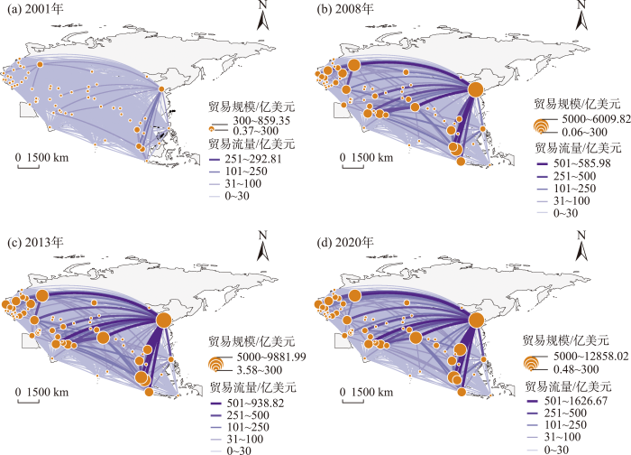
图1
“一带一路”贸易网络格局演化
注:本图基于自然资源部标准地图服务系统下载的审图号为GS(2016)1667号的标准地图制作,底图无修改,下同。
Fig.1
Evolution of "the Belt and Road" trade network patterns
自2001年以来,“一带一路”沿线地区国际贸易发展迅速,网络规模总体呈现出先增加后减少的变化趋势。2001—2008年,“一带一路”贸易规模从0.36万亿美元快速增长至1.85万亿美元,年均增长率高达26.21%,贸易流量大幅增加。之后,“一带一路”区域贸易稳步增长,至2013年,贸易总量达到2.53万亿美元,5年间共增长了0.68万亿美元,年均增长率为6.46%。在这一阶段,由于2008年全球金融危机的影响,从2009年开始全球经济进入一个相对衰退期,“一带一路”沿线地区国际贸易发展趋于平缓,但贸易网络连通性进一步加强。自2013年以来,“一带一路”倡议有力推动了沿线国家间的经贸合作,贸易网络连通性持续提升。然而进入2020年以后,由于受新冠疫情和复杂国际形势等因素叠加影响,“一带一路”贸易发展也进入了调整期,2020年贸易总量相较于2013年减少了0.05万亿美元,是4个研究年份中首次出现贸易总量负增长的一年,国际贸易发展的结构性调整趋向明显。
从贸易联系上看,“一带一路”贸易网络密度不断提升,层级结构特征明显,骨干网络和中低层级网络结构共同推动了整体网络结构的发展和完善。其中,中国是“一带一路”贸易网络的核心节点,特别是2008年以后基本形成了以中国为核心的“一带一路”贸易网络骨架。同时,像印度、俄罗斯、新加坡和马来西亚等国家也在“一带一路”贸易网络中占据重要地位。其中,中国及东南亚国家在“一带一路”整体和区域贸易体系中的地位和作用日益凸显,成为核心和次核心国家,这一点与以往研究结论类似[21]。2001年,新加坡—马来西亚之间的贸易额在“一带一路”区域中最高,达到292.81亿美元,占该年份沿线国家间贸易总额的8.06%;其次是新加坡—中国之间贸易额,为123.33亿美元;马来西亚—中国之间的贸易额以100.07亿美元位居第3名。之后随着经济全球化进程的加快,国际贸易市场涌现出前所未有的活力,商品贸易成为沿线国家经贸合作最重要的体现之一,“一带一路”贸易规模与贸易连通性实现了成倍提升。至2008年,中国与俄罗斯之间的贸易量跃居首位,达到585.98亿美元;而新加坡—马来西亚的贸易额达到546.98亿美元,几乎为2001年的2倍。可见,在贸易网络构建初期,外交关系和地缘距离是两国间开展贸易往来的重要因素,大国主导的地缘博弈深刻影响着“一带一路”沿线地区的贸易格局变化以及贸易合作趋势[5,21]。自2008年开始,“一带一路”贸易网络中出现更多的节点对,网络可达性进一步提升,贸易网络层级结构的组织形态日趋复杂。到2013年,“一带一路”倡议的提出为沿线国家间贸易合作提供了新的机遇和平台。该年属于第一层级的节点对由2008年的5对增加至9对,而中国在此贸易网络中表现出绝对的核心地位,涵盖了第一层级90%的贸易量。到了2020年,已经有3组节点对的贸易规模超过了1000亿美元,分别是中国—越南、中国—马来西亚和中国—俄罗斯,中国逐渐成为越来越多沿线国家的最大贸易伙伴国。
从贸易规模上看,“一带一路”沿线国家贸易总量在空间上呈非均衡分布,网络中存在显著的集聚效应和极化特征。近20年来,贸易规模超过2500亿美元的沿线国家数由2001年的0个增长至2020年的5个,长期属于这一层级的国家仅有中国和俄罗斯。其中,作为首位节点,中国在“一带一路”贸易网络中的贸易量占比从2001年的16.22%上升为25.86%,集聚效应明显。与此相反的是,贸易规模小于300亿美元的节点数由58个减少至35个,侧面印证了“一带一路”贸易发展的极化效应在网络动态演化过程中愈发显现。作为全球范围内的开放型经济体之一,新加坡在“一带一路”沿线国家中贸易规模排名逐年下降,由最初的第2位跌至第6位。印度、马来西亚的贸易规模在2013年达到2500亿美元以上,越南在2020年也达到这一贸易规模。
2.2 “一带一路”贸易网络组团结构演化
“一带一路”沿线各国在贸易规模和贸易联系上差异巨大,形成了复杂多维的网络结构形态。为了更清晰地展现网络结构,越来越多的研究者采用Top网络的方法,从整个网络中提取主要成分和结构,减少节点和连边信息的冗余和相互遮罩[23,25]。具体地,为每个国家保留其贸易量排名靠前的贸易联系,并对所有国家的计算结果采取并集[8]。因此,本文首先采用Top网络方法提取各年份贸易网络中的Top网络,进一步利用组团识别中的Leiden算法划分不同年份“一带一路”贸易网络中的组团结构。计算得出4个年份网络组团结构的模块度分别为0.45、0.41、0.39和0.35,也说明各年份组团划分结果具有良好的稳健性。具体结果如图2所示。
图2
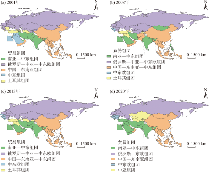
图2
“一带一路”贸易网络组团结构演化
Fig.2
Evolution of the community structures of "the Belt and Road" trade network
近20年来,“一带一路”贸易网络可大致划分为5个贸易组团。2001年,“一带一路”贸易组团包括俄罗斯—中亚—中东欧组团、中国—东南亚组团、南亚—中东组团、中东组团和土耳其组团。其中,俄罗斯—中亚—中东欧组团由16个中东欧国家、4个中亚国家和1个东北亚国家,共21个国家组成。该组团是网络中体量最大的贸易组团,其涉及的贸易总量占“一带一路”整体贸易规模的27.50%。排名第2位的是中国—东南亚组团,它由中国、10个东南亚国家、4个西亚北非国家和3个南亚国家,共18个国家构成。5个西亚北非国家、3个中东欧国家和1个中亚国家组成了土耳其贸易组团,该组团横跨欧亚非三大陆,是“一带一路”贸易网络中的重要桥梁。南亚—中东组团则由8个国家构成,分别是3个西亚北非国家和5个南亚国家。中东组团全部由西亚北非国家组成,共有7个成员国。2001年,5个组团在空间上呈现出明显的分区,运输距离和地缘政治成为沿线国家在寻求贸易合作伙伴时的主要考虑因素。
2008年,“一带一路”贸易组团数量没有变化,但组团结构发生了动态变化。以俄罗斯为核心的俄罗斯—中亚—中东欧组团依然是“一带一路”贸易网络中拥有成员国数量最多的贸易组团,共有19个国家组成。而以中国为核心的贸易组团,除了与传统东南亚国家普遍相连外,还吸纳了阿拉伯联合酋长国、阿曼和也门等中东国家,形成了由16个国家构成的中国—东南亚—中东组团。早在2002年,中国与东南亚国家就共同签署了《中国—东盟全面经济合作框架协议》,自此中国与东盟的经贸合作进入了新的发展阶段;而由于能源贸易的重要性,中国对中东国家的能源资源具有巨大需求,能源贸易成为这一时期中国与中东地区的主要贸易形式。在南亚—中东组团中,成员国数量大幅上升,包含了15个国家,其超越土耳其组团成为贸易网络中的第三大组团。其中,自印度和新加坡于2005年签订《印度—新加坡全面经济合作协定》以来,印新两国经贸合作不断深化,新加坡成为印度的第二大外资国。因此,新加坡从2001年的中国—东南亚组团转移至南亚—中东组团,与印度共同成为该组团中的双核心国家。土耳其组团由8个西亚北非和1个中亚国家构成,表现出明显的地理邻近和地缘区位选择,正如叙利亚是黎巴嫩与伊拉克、土耳其进行贸易往来的唯一陆路通道。中东欧组团脱离于俄罗斯—中亚—中东欧组团,后续发展成为以塞尔维亚、斯洛文尼亚等6个中东欧国家共同组成的新兴组团。
继2008年全球金融危机后,“一带一路”沿线各国也受到不同程度影响,2013年的贸易组团格局经历了局部重组。其中,俄罗斯—中亚—中东欧组团、南亚—中东组团的成员国数量均减少了3个,中国—东南亚—中东组团和中东欧组团的成员国数量分别增加了2个和4个。中国与东南亚国家贸易联系日益密切,2013年所有东南亚国家均归属于中国所在的组团。除了地理区位优势外,中国与东南亚国家之间产业内分工水平较高,两者具有明显的产业内贸易特征,更易于促成贸易合作和协作,且随着中国与东盟经贸合作进程深入发展,中国与东南亚国家间形成了更加紧密的贸易联系。同时,更多中东欧国家被划分至中东欧组团,该组团在“一带一路”整体网络中的贸易规模占比由2008年的1.93%上升至2013年的6.24%,组团内部合作水平有所加深。土耳其组团在2001—2013年成员国数量稳定,均为9个,仅1个国家有所变化,即土库曼斯坦从原先的俄罗斯—中亚—中东欧组团加入土耳其组团,而格鲁吉亚与之相反。为了加强两国经贸合作,土库曼斯坦与土耳其先后签署了多份双边协议,两国在2013年的贸易量达到了27.65亿美元,占土库曼斯坦该年贸易总量的15.98%。
“一带一路”倡议的提出进一步巩固并促进了沿线国家间的贸易合作,原有的贸易组团格局正在经历重构,2020年形成了新的贸易组团结构。中国—东南亚组团不断壮大,成员国数量增长至21个,与2001年的俄罗斯—中亚—中东欧组团持平,而贸易量是后者的近14倍,这是贸易规模扩大和贸易网络深化发展的结果。另一个正向发展的组团是南亚—中东组团,凭借17个成员国成为“一带一路”区域的第二大贸易组团。中亚组团脱离于2013年的俄罗斯—中亚—中东欧组团和土耳其组团,由5个中亚国家组成,形成了独立的贸易组团。在临近中亚国家独立30周年的时代背景下,中亚国家间持续强化区域内合作,良好的区域合作基础也有利于消除国际形势波动等因素带来的潜在影响。中东欧组团则依然保持由10个成员国构成,其中保加利亚、摩尔多瓦和罗马尼亚代替阿尔巴尼亚、捷克和斯洛伐克成为该组团中的新成员。而俄罗斯—东欧组团规模进一步缩小,仅由12个国家组成,组团中的中东欧国家数量逐年减少,南亚和北非国家不断增加。近年来,随着俄罗斯与欧盟关系的微妙变化,俄罗斯与部分中东欧国家的贸易往来也不断弱化,开始寻求西亚和北非等周边国家贸易市场,但该贸易组团整体规模呈现出缩小趋势。土耳其在2020年则隶属于南亚—中东组团。
2.3 “一带一路”贸易网络核心—边缘结构演化
基于核心—边缘轮廓算法[43],本文进一步计算得到了衡量“一带一路”贸易网络中核心—边缘效应的集中系数和体现节点在网络中地位和角色的核心度。其中,2001、2008、2013和2020年4个年份的集中系数分别为0.72、0.75、0.77和0.79,表明“一带一路”贸易网络具有明显的核心—边缘结构,且核心—边缘结构极化效应明显,并呈稳步上升趋势。参照已有文献[28],根据核心度指标,进一步把沿线国家划分为4种类型。其中,核心度大于0.30的节点被划分为核心国家,核心度在0.11~0.30的节点被划分为次核心国家,核心度在0.01~0.10的节点被列为次边缘国家,而边缘国家则是指剩余的核心度低于0.01的全部节点(图3)。
图3
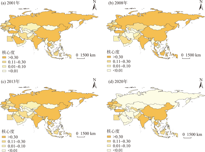
图3
“一带一路”贸易网络核心—边缘结构演化
Fig.3
Evolution of the core-periphery structures of "the Belt and Road" trade network
总体上,“一带一路”贸易网络的核心—边缘结构正在经历结构性调整,核心结构和边缘结构呈现出明显的分化,核心—边缘极化效应明显。具体地,超过半数的国家在网络中的核心度等级发生了变化,核心国家和边缘国家间的差距不断拉大,位于核心结构的国家正在减少。核心国家数量从2001年和2008年的11个减少为2013年与2020年的9个;而处于边缘位置的国家却在不断增加,20年间从24个持续增长至29个;半核心与半边缘国家的数量也随之出现波动变化。从发展机制上,核心—边缘结构的动态变化是“一带一路”贸易网络在受到内部因素(政局形势、经济结构和政策调整等)和外部因素(国际形势、对外关系、贸易市场变化等)多重因素影响下的自我调节反馈。
在核心结构中,近20年来,中国、印度、新加坡、土耳其、泰国和匈牙利6个国家一直属于核心国家。其中,自2008年经历全球金融危机后,中国超越新加坡和俄罗斯成为整个“一带一路”贸易网络中的核心国家。难以忽略的是,中国始终为“一带一路”进出口贸易总量最大的国家。作为南亚最大的国家,印度在贸易网络中的地位也一路攀升。然而,自2008年以来,受到卢比贬值、外汇储备下降以及世界经济整体形势等因素影响,印度的对外贸易由2001年的顺差转为逆差,贸易赤字持续扩大。凭借独特的地理区位,新加坡和土耳其在贸易网络中扮演着重要角色。前者是全球范围内著名的转口贸易港,承担着该区域贸易体系中大量的转口贸易;后者地处欧亚非三大洲交界处,经济规模和地缘优势突出,故此有机会重回贸易枢纽的核心位置。受国际政治经济环境等因素,泰国在“一带一路”贸易网络中的核心度持续降低。作为中东欧地区的门户枢纽,匈牙利在“一带一路”贸易网络中的地位和作用长期稳定,20年来核心度浮动仅为0.0160。
值得注意的是,有4个国家在2020年“一带一路”贸易网络的“核心—边缘”结构中出现了明显的等级突变。2020年,俄罗斯、阿拉伯联合酋长国和沙特阿拉伯3个国家同时由历年的核心或半核心国家转变至边缘国家,核心度降低显著。由于国际环境、新冠疫情、石油价格波动等多重影响,阿拉伯联合酋长国和沙特阿拉伯2个极大依赖石油出口的国家受到重创,与其他国家的贸易往来也大大减少。俄罗斯与欧盟长期紧张的经贸关系导致其在2020年的对外贸易大幅下降,经济萎缩明显。与此同时,白俄罗斯则在2020年表现出强大的经济活力,从往年的半边缘国家跻身至核心国家,这主要得益于白俄罗斯与中国间贸易量的极大增长。
此外,归属于边缘或半边缘国家的数量不断增多,从2001年的39个国家逐渐上升至2020年的44个国家。保加利亚、斯里兰卡、阿塞拜疆、黎巴嫩、吉尔吉斯斯坦、斯洛伐克共和国和格鲁吉亚等国长期处于“一带一路”贸易网络中的边缘或半边缘位置,上述国家普遍对外贸易规模较大、贸易联系简单,主要集中于同邻近接壤国家建立贸易联系。
2.4 “一带一路”贸易网络骨干结构演化
从连通性出发,进一步运用视差过滤算法,在保留网络的主要属性和结构的前提下,剔除原始网络中边数过多对网络骨干识别的干扰,识别贸易网络中的骨干框架。这些骨干结构是整个网络的核心结构,支撑起整个贸易网络的联系和运行。计算结果如图4所示。随着时间演化,“一带一路”贸易网络骨干结构不断拓展和分化,呈现出向核心国家集聚的变化趋势,形成了以中国为绝对核心、向外辐射并联系整个区域的骨干网络格局,印度、俄罗斯、土耳其在局部区域也形成了各自的骨干网络。
图4

图4
“一带一路”贸易网络骨干结构演化
Fig.4
Evolution of the backbone structures of "the Belt and Road" trade network
在时序上,“一带一路”骨干网络密度呈现先增加后减少的过程,骨干网络整体更加集中。2001年,沿线国家间的216组贸易对构成了“一带一路”贸易网络的骨干结构。在该骨干结构中,中国和俄罗斯分别与38个和30个国家构建了贸易联系,是网络中最重要的2个枢纽国家。到2008年,“一带一路”贸易网络的骨干结构实现进一步拓展和丰富,共出现了241条贸易对,比2001年多出25条。除了中国和俄罗斯,印度和土耳其在骨干网络中的合作国家数也有所提升。在全球经济重心日趋东移背景下,为了实现进口多元化,印度同沙特阿拉伯、伊朗、伊拉克和科威特等8个中东国家的经贸关系不断加深。随着地缘政治和对外经济联系的强化,土耳其从乌克兰的进口额由2001年的7.58亿美元大幅增长至2008年的61.06亿美元。2013年共有240条贸易对构成“一带一路”骨干网络,与2008年的骨干网络重合度高达83.33%,且该部分贸易额占据2013年总贸易额的83.85%。这也说明,在这一时期“一带一路”沿线国家贸易环境相对稳定,在维系现有贸易合作伙伴的基础上,贸易骨干结构未发生重大变化,上述骨干结构是“一带一路”沿线贸易合作的主体结构。“一带一路”倡议的正式提出,是沿线国家实现互联互通的历史前提。2020年,骨干网络转变为由218条贸易对构成,较2013年共减少了22条,贸易骨干结构进一步明晰,展现出一定程度的集聚态势,“一带一路”骨干结构正在经历明显的空间重构过程。在贸易结构上表现为,“一带一路”各国间的贸易伙伴选择近9成集中在中国、土耳其、印度、俄罗斯、波兰、泰国、新加坡、塞尔维亚、匈牙利和保加利亚等10个国家。
从骨干节点来看,“一带一路”贸易骨干网络开始向少数国家集聚,中国、俄罗斯、印度是骨干网络中的传统重要节点。中国始终是骨干网络中最具连通性的国家,近20年来,其贸易对数量一直随网络的演变不断增加,从2001年的38条增加至2020年的59条。正如《“一带一路”建设发展报告(2020)》中指出,中国在“一带一路”贸易网络中发挥着越来越重要的枢纽与发动机作用,同“一带一路”沿线国家间的贸易合作水平也在不断提升[45]。而俄罗斯近年来受国际关系影响,在2020年贸易对数量下跌至20条。印度在骨干网络演变过程中相对稳健,其贸易对数量仅在2008年有所上升,后续年份保持不变。土耳其和波兰的贸易对数量保持增长态势,2001年以来,前者从12条增长至2020年的24条,后者由8条增长至16条,均增长了1倍。而受限于资源禀赋和国际经贸市场变化等影响,新加坡在“一带一路”贸易网络中的地位和作用逐步降低,在骨干网络中的贸易对由2001年仅次于中国和俄罗斯的22条一直减少至2020年的11条,说明其网络连通性已大为降低。但不可忽视的是由于地理区位和港口优势,新加坡依然是重要的贸易枢纽[46]。
3 结论与讨论
(1) “一带一路”贸易网络联系持续增加、网络密度不断提升,贸易规模分布呈现出空间异质性,逐步形成了具有明显层级结构、空间上非均衡分布、贸易联系日益紧密的贸易网络格局。其中,无论是在贸易规模上还是贸易联系上,中国均为“一带一路”贸易网络的绝对核心,基本形成了以中国为核心的贸易网络骨架。
(2) “一带一路”贸易网络形成了5个贸易组团,组团结构具有显著的地理邻近性,地理距离在全球及区域尺度的国际贸易体系分工演化中依然具有重要作用。
(3) “一带一路”贸易网络的核心—边缘结构正在经历结构性调整,核心结构和边缘结构呈现出明显的分化,核心—边缘极化效应明显。
(4) “一带一路”贸易网络骨干结构不断拓展和丰富,呈现出向核心国家集聚的变化趋势,形成了以中国为绝对核心、向外辐射并联系整个区域的骨干网络格局,印度、俄罗斯、土耳其在局部区域也形成了各自的骨干网络。
“一带一路”倡议旨在实现更广泛的国家和更大规模的人口共享人类发展成果,实现互利共赢、合作发展,构建人类命运共同体。但从“一带一路”贸易网络连通性上看,区域不平衡发展问题依然突出。未来,“一带一路”经贸合作在充满机遇的同时,也面临着诸多挑战和问题。“一带一路”建设应更加坚定不移地推动经贸合作,提高沿线国家间贸易连通性水平,建立更高水平、更广范围的自由贸易协议体系,进一步降低贸易壁垒、减少贸易争端、消除贸易对抗,充分释放国际贸易带来的合作发展和互利互惠,让贸易发展的好处普及更多的沿线国家和人民。结合当前国际政治经济形势,一方面,中国应坚定地推动与沿线地区更加开放、更高水平的经贸合作,促进与沿线区域的贸易互联互通,提高在“一带一路”贸易网络中的地位和影响力;另一方面,也应更加注重与贸易节点国家的经贸合作,提升应对外部冲击和节点损失带来的潜在影响,加快构建复杂嵌套、多元互补、自主可控的商品链和供应链网络体系。
网络中的多尺度结构一直是网络科学领域的前沿议题,节点和连边在不同尺度上的相互作用共同塑造了具有复杂性和动态性的网络拓扑结构。其中,中尺度结构介于宏观和微观尺度之间,提供了一种透视网络中内蕴的固有的结构性特征的分析视角,对于理解和认识网络连通性具有至关重要的意义。网络连通性是测度经济体重要性和贸易网络运作的关键指标。本文构建了近20年“一带一路”贸易网络,利用多种网络分析前沿算法从“点—边”2个维度间接展现和探讨贸易网络连通性,但仍缺乏对网络连通性的直接量化表达。同时,由于不同类目产品的贸易价值在贸易网络中并不具有一致性,尤其是能源、矿石等具有强地理依附性的产品。因此,下一步研究考虑着眼于进一步细化贸易产品或聚焦至某一具体产品,结合网络分析前沿算法,深入研究贸易网络结构连通性演化测度的量化表征,以期更好地挖掘“一带一路”贸易网络演化背后的驱动机制及其空间效应。
参考文献
“一带一路”建设研究进展
[J].
DOI:10.11821/dlxb201804003
[本文引用: 1]

“一带一路”经历了从中国倡议到国际共识的巨大转变,正在成为世界上越来越多国家和政治领袖们探索全球经济治理新模式的平台。伴随这种转变以及“一带一路”建设所取得的成就,“一带一路”研究已经深入到除了基础科学领域外的几乎所有学科。本文根据中国知网(CNKI)数据分析了4年多来“一带一路”研究文献的特征,而后总结了与地理学密切相关的“一带一路”核心议题的研究进展。研究发现:① 自2014年以来“一带一路”研究发文量迅速上升,由2014年的1000多篇飙升到2017年的20000多篇;② 文献比较庞杂,以宏观性、战略性和一般性文献为主,舆论性很高,基于深入研究的高水平学术文献少,还不能很好地支撑“一带一路”建设;③ 对外直接投资、互联互通、“走出去”、全球化、全球治理、命运共同体、人民币国际化等得到的关注较多;④ 地理学在“一带一路”的战略内涵和理论构建、地缘政治经济分析、“中欧班列”、海上航运战略支点、海外投资模式、经贸格局及其经济影响、资源环境问题等方面研究较为深入。最后,本文呼吁加强“一带一路”的理论建构以及建设机制和国别研究,并积极开展中外学者之间“一带一路”研究对话以及合作研究。
Progress in research on the Belt and Road Initiative
DOI:10.11821/dlxb201804003
[本文引用: 1]
The Belt and Road Initiative (BRI) has changed from a China-based initiative to an international consensus, and is becoming a platform for a growing number of countries in the world to explore new international economic governance mechanisms. Such a great change along with impressive achievements of BRI development has attracted academic attention from almost all disciplines except basic sciences, giving rise to huge literature. This paper will first explore data from China Knowledge Resource Integrated Database to summarize the characteristics of literature on BRI in general, and then review progress in research on major BRI topics related to geography. The paper finds: (1) the number of Chinese papers on BRI increased by 21 times in three years, from 1012 in 2014 to 21216 in 2017; (2) these papers cover various BRI-related topics but most of them are macroscopic and very general studies of BRI with a taste of public voices, implying that quality papers with deep academic studies are demanded to support the BRI development; (3) more frequently discussed topics are China's outward foreign direct investment, facilities connection, "going out", globalization, global economic governance, community of shared destiny and internationalization of Renminbi; and (4) specific topics that are more deeply studied by geographers are connotation and discourse of BRI, geopolitical analysis of BRI, China-Europe Express Train, global strategic shipping pivot, model of China's outward foreign direct investment and overseas industrial parks, trade pattern and its impacts on economic growth of both China and its trade partners. Lastly, the paper suggests enhancing the discursive construction of BRI and studies of new BRI mechanisms as well as studies of countries involved in BRI, and promoting dialogues and collaborations between Chinese scholars and foreign scholars on BRI studies.
“一带一路”战略的科学内涵与科学问题
[J].
DOI:10.11820/dlkxjz.2015.05.001
[本文引用: 2]
“一带一路”指“丝绸之路经济带”和“21世纪海上丝绸之路”,是中国为推动经济全球化深入发展而提出的国际区域经济合作新模式。其核心目标是促进经济要素有序自由流动、资源高效配置和市场深度融合,推动开展更大范围、更高水平、更深层次的区域合作,共同打造开放、包容、均衡、普惠的区域经济合作架构。“一带一路”框架包含了与以往经济全球化完全不同的理念,即“和平合作、开放包容、互学互鉴、互利共赢”,这正是丝绸之路文化内涵的体现。本文分析了“一带一路”战略与经济全球化及世界格局变化的关系;剖析了其空间内涵,认为“一带一路”具有多重空间内涵和跨尺度特征,是统筹中国全面对外开放的国家战略。最后,提出了推进“一带一路”建设为地理学提出的几个重要议题,包括地缘政治、国别地理、对外直接外资理论、交通运输优化组织等。
Scientific understanding of the Belt and Road Initiative of China and related research themes
DOI:10.11820/dlkxjz.2015.05.001
[本文引用: 2]
The Belt and Road Initiative—where the "Belt" stands for the Silk Road Economic Belt and the "Road" stands for the 21st Century Maritime Silk Road—is a call of China for new modes of regional economic cooperation under the trend of development of economic globalization. It targets at promoting orderly and free flow of economic factors, efficient allocation of resources, and deep integration of markets; enabling the countries along the Belt and Road to achieve economic policy coordination and carry out broader, deeper, and more efficient economic cooperation; and jointly building an open, inclusive, and balanced regional economic cooperation architecture. Thus the Belt and Road Initiative is an alternative road to further economic globalization, but contains ideas that are different from the past, that is, the spirit of the Silk Road—"peace and cooperation, openness and inclusiveness, mutual learning and win-win." Based on such an understanding, this article first analyzes the general background of the Belt and Road Initiative against economic globalization and the changing configurations of the world, and then discusses the Initiative's spatial connotation by revealing its multi-scalar and trans-scalar characteristics. The article points out that the Belt and Road Initiative is a national strategy, rather than a regional strategy, to coordinate all-around opening of China to the world and promote further integration of the country into the global economy. Last, the article suggests several research themes in geography that are brought about by the Belt and Road Initiative, including geopolitical studies, geography of countries of the region to explore cooperation opportunities, foreign direct investment theories advanced by the Belt and Road Initiative, and optimization of transcontinental transportation.
Inclusive globalization: Unpacking China's Belt and Road Initiative
[J].DOI:10.1080/23792949.2016.1232598 URL [本文引用: 1]
从地缘关系视角解析“一带一路”的行动路径
[J].
DOI:10.11821/dlyj201801001
[本文引用: 2]
“一带一路”倡议是人类历史上最伟大的全球治理工程,开辟了政治地理学研究的新纪元,为地缘关系研究提供了大舞台。地理学是从时间、空间和自然—社会系统三个维度理解陆地表层过程的科学,对地缘关系研究具有独特的功能和作用。因此,从地理学视角研究地缘关系具有其他学科无法比拟的优势。“一带一路”是当前最具挑战的科学和政策命题,从地缘关系视角研究“一带一路”,需要加强四个方面的结合:① 在科学思维上,需要还原论与系统论思维相结合;② 在科学数据建设上,需要社会人文与自然环境数据相结合;③ 在科学问题选择上,需要社会过程、人文过程、政治过程和自然过程相结合;④ 在研究方法上,需要经验方法、实证方法、系统方法与大数据研究方法相结合。中国地理学者应兼顾政治地理学科建设、地缘关系的学科交叉研究和“一带一路”全球实践开展研究。
Undertaking research on Belt and Road Initiative from the geo-relation perspective
DOI:10.11821/dlyj201801001
[本文引用: 2]
The Belt and Road Initiative is the greatest project aimed to improve global governance in human history ever before. It opens a new era for the research of political geography, and in particular it provides great opportunities for geo-relation research. Geography is a science that explores the surface of earth from three perspectives including the time, space and nature-society system, which equips it to undertake geo-relation research with unique tools and advantages. The Belt and Road Initiative is one of the most challenging scientific and policy issues in the world. To better study the Belt and Road Initiative from the geo-relation perspective, geographers need to make combinations in the following four ways: (1) combining reductionism and system theory in scientific thoughts; (2) combining data of both human-society and nature-environment; (3) combining research questions based on social, human, political and natural processes; (4) combining research methods on empirical, positivism, systematic, and big data. Chinese Geographers need to give considerations to balance the development of political geography, multi-discipline oriented research on geo-relations and the implementation of the Belt and Road Initiative globally.
The Belt and Road Initiative and the transit countries: An economic assessment of land transport corridors
[J].DOI:10.1080/23792949.2017.1385406 URL [本文引用: 1]
中国对“一带一路”沿线国家直接投资的风险及其防范
[J].
China's risks and prevention of outward foreign direct investment in countries along "the Belt and Road"
The structure and evolution of trade relations between countries along the Belt and Road
[J].
DOI:10.1007/s11442-018-1522-9
[本文引用: 3]
<p>Trade facilitation is one of the five main agendas of the Belt and Road Initiative (BRI). Social network analysis has helped understand the complexity of trade networks, but existing studies tend to overlook the fact that not all bilateral trade relations are equally important to a country. To fill this gap in the literature, this paper focuses on the top 2 trade relations networks to illuminate the structure and evolution of B&R trade relations, the relative positions of different countries, and changes in the composition of trade communities (e.g., the community leaders) and the changing patterns of trade between them. We find rich dynamics over time both inter- and intra-communities. The overall international trade networks of B&R countries experienced a leadership change from Russia to China on one hand, some temporary communities experienced emergence, disappearance (e.g. the Kuwait- and Thailand-led communities) or reemergence (e.g. Poland-led community), and a community membership was generally consistent on the other hand. Since the future impacts of China’s BRI will depend on the degree of integration of the connected regions, some countries with stable and high centrality indices (e.g. Russia, Singapore, Serbia, Greece, Turkey, Iran, Poland, Hungary and Romania) could be selected by China as strategic regional partners, and countries with a strategically important geographical position but weak trade links (e.g. Myanmar, Pakistan, and Belarus) should be prioritized.</p>
“一带一路”倡议下中国与重要节点地区的贸易格局及影响因素: 以外高加索国家为例
[J].
Trade pattern and its influencing factors between China and important node regions under "the Belt and Road" Initiative: A case study of transcaucasia countries
共建“一带一路”取得的重大成就与经验
[J].
The major achievements and experience in the joint construction of the Belt and Road Initiative
外资服务构建新发展格局的理论逻辑与路径分析
[J].
Analysis on theoretical logic and path of foreign capital's role in building a new development pattern
国际贸易地理研究进展
[J].
DOI:10.18306/dlkxjz.2020.10.012
[本文引用: 2]
全球化时代的技术进步和贸易自由化似乎逐渐将世界经济连为一体,但研究发现国际贸易仍然显著地受到地理因素影响。与此同时,经济地理学对国际贸易地理的理论建构存在欠缺,其对国际贸易研究的贡献目前集中于对国际贸易地理格局和贸易网络异质性的描述分析上。在此背景下,论文从生产、流通和消费3个方面归纳国际贸易研究对地理因素作用的理论建构和实证研究:① 生产上的地理差异经由机会成本差异促进贸易;② 流通上的地理差异经由贸易成本而抑制贸易;③ 消费上的地理差异经由市场需求地空间差异而影响贸易。通过总结贸易与制度变迁、贸易与集聚、贸易与不平等、贸易与创新、贸易与污染间的关系相关研究,论文认为当前国际贸易研究存在如下局限:① 并未深入讨论地理变量的内生性,即贸易可能反过来塑造地理差异而非仅由地理变量决定;② 相对缺乏多尺度、跨尺度视角,即贸易理论预测的宏观尺度贸易利得在中观、微观主体上并非均等分配,表现出显著的空间差异;③ 部分研究对产品异质性缺乏探讨,无法全面刻画贸易的差异化地理效应。据此,经济地理学未来对国际贸易研究的贡献可能在于运用多尺度、跨尺度联系的视角深入阐释贸易与地理的多维度异质性和复杂互动。
A review on geographies of international trade
DOI:10.18306/dlkxjz.2020.10.012
[本文引用: 2]
It is expected that the world economy would be gradually integrated and interconnected by trade liberalization and progress in technology in globalization era. However, researchers have found that international trade remains significantly affected by geographies. At the same time, economic geographers put little effort on building theories about geographies of international trade and their main contribution in this field is confined to descriptive analysis on the heterogeneous patterns and network structures of international trade. In this article, how geographies affect trade in international economic studies is reviewed from three dimensions—production, circulation, and consumption. Differences on production side promote trade through the intermediation of opportunity cost while differences in circulation process hinder trade by increasing trade cost. Differences on consumption side affect trade through the intermediation of demand level. By summarizing the literature on the relationship between trade and institutional change, trade and urban agglomeration, trade and inequality, trade and innovation, and trade and pollution, we identify three major limitations of these studies. First, few studies dig into the endogeneity of geography systematically. Spatial disparity can be shaped by international trade rather than only determining international trade. Second, there is a dearth of multi-scale and inter-scale perspective despite that gains from trade at the macro level predicted by traditional trade theory are found not evenly distributed at the meso and micro levels, resulting in evident spatial disparity. Third, some of the studies do not fully explore product heterogeneity, thus cannot completely capture the various spatial impacts of trade. Therefore, possible contribution of economic geographers to international trade studies lies in thorough investigation on multi-dimensional heterogeneity and complex interactions between geographies and international trade from multi-scale and inter-scale perspective.
Visualizing the changing geographies of international trade, 2000-19
[J].DOI:10.1080/21681376.2022.2043770 URL [本文引用: 1]
Structural change, trade and global production networks: An 'appropriate industrial policy' for peripheral and catching-up economies
[J].
DOI:10.1016/j.strueco.2018.04.001
[本文引用: 1]
The global economy has been undergoing rapid structural change: the impressive development processes in a range of emerging economies have induced strong shifts in global trade shares: international production networks (IPNs) are characterising regional and global trading relationships and we observe also persistent changes in the positions of countries in global value chains due to rather rapid technological and human capital up-grading. The aim of this paper is to assess these developments, but also discuss the importance of - what we call - 'appropriate industrial policy' (AIP) for countries at different developmental stages to support their position in the current global context. We shall emphasise in particular the role of AIP for European low- and medium-income economies (LMIEs) as the recent financial and economic crisis has shown that they are particularly vulnerable with respect to 'structural external imbalances' and thus policies to support their tradable sectors are of great importance. (C) 2018 Published by Elsevier B.V.
Growing world trade: Causes and consequences
[J].DOI:10.2307/2534577 URL [本文引用: 1]
The cosmopolitanization of trade regions: Global trends and implications, 1965-1990
[J].
The geography of international trade
[J].DOI:10.1177/030913259401800302 URL [本文引用: 1]
Geographies of international trade: Theory, borders, and regions
[J].DOI:10.1111/j.1749-8198.2009.00314.x URL [本文引用: 1]
International trade, geographic heterogeneity and interregional inequality
[J].
Spatiotemporal dynamics and topological evolution of the global crude oil trade network
[J].The high separation of crude oil supply and demand markets has led to the formation of a global crude oil trading system. This paper constructs global crude oil trade networks, integrates macro, meso, and micro network analysis methods, combines geospatial visualization techniques, and then portrays the spatiotemporal patterns and topological evolution of the global crude oil trade networks. Thus, it attempts to dig deeper into the world crude oil competition and cooperation links and evolution laws and provides a scientific reference for a comprehensive understanding of the global crude oil market dynamics. The results show that: (1) After three fluctuations of increase and decrease since 2000, the global crude oil trade volume is entering the adjustment period, and the scale of the crude oil market is rising slowly. (2) The international crude oil trade has formed trade network patterns with complex structures, clear hierarchy and unbalanced distribution. The “rich club” phenomenon is significant, with large trading countries dominating the trade network. (3) The scale and density of the global crude oil trade network show a trend of increasing and then decreasing, the network agglomeration pattern becoming more obvious, the inter-nodal links continuously strengthening, and the network connectivity improving. (4) The global crude oil trade networks are characterized by core–periphery structures, and the polarization effect is significant. The US, Russia, China, Japan, the Netherlands, and South Korea hold the core positions in the crude oil trade network, and the major importing countries have become the dominant forces in the trade network. In addition, we present policy suggestions for different types of countries for energy transformation and security in the global trade market system, which can be used as a reference for policymakers.
“一带一路”沿线国家贸易网络空间结构与邻近性
[J].
DOI:10.11821/dlyj201811008
[本文引用: 5]
“一带一路”倡议致力于构建全方位、多层次、复合型的互联互通网络,沿线国家之间相互贸易形成的网络有利于加速经济要素跨区域的自由流动,进一步提升“一带一路”区域经济资源的整合效率,对重塑欧亚大陆政经版图和优化中国地缘环境具有重大影响。采用复杂网络和地统计方法,借助GIS、Pajek、Ucinet和数据库等技术手段,对“一带一路”贸易网络的拓扑性质、空间结构以及节点的邻近性深入研究。主要结论有:① “一带一路”沿线国家贸易网络具有小世界和无标度性质,遵循增长性和择优选择;② 沿线国家贸易具有典型的“核心—边缘”等级性,中国对沿线国家产业升级和经济发展具有引领和带动作用;③ 贸易网络是“混合型”结构,呈现枢纽辐射式为主、全连通式并存的联系模式,不同中心性空间分布差异显著;④ 拓展引力模型对“一带一路”沿线国家贸易网络具有较强的解释力,贸易关系存在大国效应和地理邻近效应,科研邻近和语言邻近是重要的推动力,制度邻近的影响呈显著负相关,文化邻近的正向作用相对较弱。因此,中国宜遵循“由近及远”的原则,重点强化对邻近国家的贸易渗透,再加强对沿线重点国家的贸易辐射,进而向重点国家的周边地区拓展,从不同空间层次制定差异化政策,发挥科研和语言邻近的推动作用,强化对沿线国家的文化渗透。
Network structure and proximity of the trade network in the Belt and Road region
DOI:10.11821/dlyj201811008
[本文引用: 5]
<p>The Belt and Road Initiative (B&R) is aimed at building a multi-faceted, multi-dimensional, and a compositely interconnected network. The B&R orderly accelerates the free flow of economic factors across the area and further increases the integrated efficiency of regional economic resources in the B&R region, which has significant influence on reshaping the political and economic landscape of Eurasia and optimizing the geopolitical environment around China. Based on the complex network theory and the geostatistical analysis, this research focuses on the topological features and the spatial structure of the B&R trade network and the proximity of its nodes, by building a database and applying the related techniques, such as ArcGIS, Pajek, and Stata. The main conclusions are as follows: (1) The trade network in the B&R region is a small world and scale-free network. It keeps growing and follows the optimum selection rules, which means the new nodes preferably connect with the existing nodes of higher degree in the network. (2) Countries in the B&R trade network display the typical core-periphery hierarchical character. China plays a leading role in promoting industrial upgrading and economic development for these countries. (3) The structure of the B&R trade network shows a "mixed" structure, including both the hub-spoke and the fully-connected modes. The spatial heterogeneity among different kinds of centralities is significant. (4) The extended gravity model can better explain the B&R trade network. There exist the "Powers' Effect" and the "Geographical Proximity Effect" in the trade relationship. In the B&R trade network, scientific and language proximity are the most important forces. Institutional proximity shows a significantly negative effect, while cultural proximity shows a relatively weak effect. As a result, China should develop diverse policies that are based on different spatial levels, enhance the trade with the neighbouring countries first, and then to the distant ones and their surrounding areas; leverage the advantage of scientific and language proximity to promote the trade with other countries, and strengthen the cultural infiltration along the B&R region.</p>
21世纪以来全球粮食贸易网络空间格局演化
[J].
Spatial pattern evolution of global grain trade network since the 21st century
基于产业链的全球铜贸易网络结构研究
[J].
DOI:10.13249/j.cnki.sgs.2021.01.005
[本文引用: 2]
基于产业链视角研究铜贸易网络,构建了2017年铜矿石、粗铜、精炼铜、铜材和废杂铜5类含铜产品的全球贸易网络,对比产业链上各环节产品的贸易网络的拓扑结构,以全面刻画铜资源的全球流动以及国家(地区)之间的铜贸易关系。主要结论如下:① 2001年以来,全球含铜产品贸易重量稳定增长,其中铜矿石贸易重量最大,精炼铜次之。② 5类含铜产品贸易网络的拓扑结构存在明显差异,根据社区发现算法可划分为4~8个组团,模块度在0.216~0.482之间。由于资源禀赋和工业体系发展程度不同,大部分国家(地区)在5类贸易网络中分属于不同的组团。③ 中国对铜资源的需求巨大,围绕着中国的需求产生的贸易关系在铜矿石、粗铜、精炼铜、废杂铜4类贸易网络中都构成第一大组团,分别包含47、102、120、135个国家(地区),表明中国在全球铜贸易中占有重要地位,但也反映了中国铜资源自给率低、对外依存度大等问题。
Structure of global copper-containing products trade network based on industrial chain perspective
DOI:10.13249/j.cnki.sgs.2021.01.005
[本文引用: 2]
By comparing topology structure of various copper-containing product trade network, this article comprehensively describes the global flow of copper resources and copper trade relations among countries or regions, which is conducive to enhancing the understanding of different countries and regions’ comparative advantages in the global value chain and promoting the sustainable use of resources. We build 5 types of global copper-containing product trade networks using bilateral trade data of copper ore, blister, refined copper, copper semis and copper scrap in the year of 2017. The data are collected from UNCOMTRADE and ITC Trade map database. Since the data are too huge to analyse, we first identify the backbone network using Top $ N $ method to simplify data and keep as much information as possible at the same time. Top2, Top2, Top3, Top10, and Top4 networks have been identified to represent the integral network of copper ore, blister, refined copper, copper semis and copper scrap respectively. After that, we adopt network analysis methods such as community detection to study the topology structures of each type of global copper-containing product trade networks, and discuss their similarities and differences. The main conclusions are as follows. 1) Since 2001, the global trade quantities of copper-containing products have increased steadily, indicating that the demand for copper resources for world economic development has been increasing continuously. Among them, the trade quantities of copper ore are the largest, followed by refined copper, and blister is the smallest. The pattern of supply and demand of 5 copper-containing products trade is different. 2) Trade relations mainly occur between countries and regions with higher industrialization level or better industrial system in the copper resource field. And there are obvious differences in the topological structure of 5 copper-containing product trade networks. 3) According to the results of community detecting algorithm, these networks can be divided into a range of communities from 4 to 8 with the module degree between 0.216 and 0.482. Most countries and regions belong to different communities in five types of trade networks due to difference in resource endowments and industrialization development stages. 4) China has huge demand for copper resource. In the trade network of copper ore, blister, refined copper and copper scrap, countries related to China’s demand formed the largest community, indicating that it occupies an important position in the global copper trade, and reflecting problems of Chinese copper resources such as the low self-sufficiency rate and large dependence on other countries and regions. China should maintain good cooperative relations with the countries and regions within the same community to reduce the supply risk of copper resources.
全球高科技产品贸易结构演化及影响因素
[J].
DOI:10.11821/dlxb202012015
[本文引用: 1]
为清晰刻画全球高科技产品贸易体系变迁,本文利用世界银行以及联合国商品贸易数据库中2000—2017年高科技产品贸易数据,从产品结构、网络结构和影响因素3个方面探讨了全球高科技产品贸易结构的演化态势。研究发现:① 产品结构上,以电信设备为主的电子通讯产品主导全球高科技贸易发展,但在国家尺度上,化学产品和武器产品是大部分国家(地区)的进口依赖产品或出口优势产品;② 拓扑结构上,全球高科技产品贸易网络持续扩张,联系紧密,是一典型的“小世界”网络,并发育出稳定的“核心—边缘”式的等级层次结构;③ 空间结构上,全球高科技产品贸易格局呈现出由欧洲—北美主导向由东亚主导转变,贸易最大国也由美国转变为中国,网络空间结构也呈现出由以美国为核心的“双拱”格局向以中国为核心的“多拱”格局转变,但美国依然在多种高科技产品贸易网络中占据核心地位;④ 影响因素上,贸易规模、经济邻近性和文化邻近性对全球高科技产品贸易网络演化皆具有一定的正向作用,地理距离对全球高科技产品贸易网络的演化起到明显的负向作用。
Structural evolution of global high-tech trade system: Products, networks and influencing factors
DOI:10.11821/dlxb202012015
[本文引用: 1]
Since 2018, with the major adjustment of the global political and economic structure, Sino-US relations, which take trade friction as the representation and science and technology competition as the essence, have become increasingly tense. Based on this, this paper characterizes the evolution of global high-tech products trade structure from three aspects of product structure, network structure and influencing factors, and draws some conclusions. First of all, in terms of product structure, global high-tech trade is increasingly concentrated on electronic communication products based on telecommunications equipment. However, on the national scale, chemical products and armament products are not only the dependence products of most countries (regions) on imports, but also the superior export products of most countries (regions). Second, in terms of topology, the global high-tech product trade network continues to expand and is closely linked. It is a typical small-world network and develops a stable "core-edge" hierarchical structure. Third, in terms of spatial structure, the global trade pattern of high-tech products has changed from Europe-North America dominated to East Asia dominated, and also the largest trade country has changed from the United States to China. In addition, the spatial structure has changed from the "double arch" structure with the United States as the core to the "multi-arch" pattern with China as the core, but the United States still occupies a central position in the trade network of various high-tech products. Fourth, in terms of influencing factors, trade scale, economic proximity and cultural proximity have positive effects on the evolution of global high-tech products trade network, while geographical distance has an obvious negative effect. The four factors of political stability, openness, infrastructure and technological innovation only pass the significance test on the importing country (region), while the economic scale only passes the significance test on the exporting country (region). The technological gap is one of the driving forces for the evolution of the global high-tech product trade network.
中国崛起与世界贸易网络演化: 1980—2018年
[J].
DOI:10.18306/dlkxjz.2019.10.014
[本文引用: 2]
随着网络分析方法的发展,利用社团检测和社交网络分析研究世界贸易网络成为当前重要的前沿问题。但目前国内外的研究多为短期尺度,中长期尺度研究亟需更新。当前世界经济发展不确定性要素增多,“一带一路”建设正进入深耕细作的阶段,分析20世纪80年代以来国际政治经济局势的转变以及发达国家与发展中国家的地位更替的长尺度变化,有利于揭示世界贸易网络的中长期演变趋势,并为中国“一带一路”建设提供历史启示。论文主要基于国际货币基金组织(IMF)的贸易方向统计数据库(DOTS),首先总结了1980—2018年世界贸易发展3大历史阶段的基本特征,然后研究了20世纪80年代以来的世界贸易网络中组团及国家地位的演变。研究发现:① 世界政治经济格局变化和技术进步对世界贸易网络影响深远。20世纪80年代以来资本主义的生产方式由福特制向后福特制的转变、新自由主义的推广、数字技术的大规模发展以及发展中国家的崛起对全球贸易空间格局产生了深远的影响,中国的崛起是全球贸易网络变化重要的力量。② 从Top1贸易网络上看,世界贸易格局呈现出“稳中有变”的演化趋势。世界贸易网络中,欧洲部分的德国、法国和俄罗斯组团相对稳定,而英国和意大利组团地位不断下降;美国主导了亚太部分,澳大利亚组团较为稳定,日本组团地位下降。③ 印度、巴西和南非等发展中国家的崛起,导致世界经济和贸易格局的重大变化,这些国家近年来成为了新兴的区域性贸易中心。④ 随着经济高速发展,中国在世界贸易中的地位迅速上升,成为了超过美国的世界贸易组团核心。最后,简要讨论了中长期尺度贸易网络研究对“一带一路”建设的历史启示。
The rise of China and change of the global trade network during 1980-2018
DOI:10.18306/dlkxjz.2019.10.014
[本文引用: 2]
With the development of the network analysis methods, studying global trade network by community detection and social network analysis (SNA) has become the frontiers in trade-related fields. However, most of the present research was of short temporal scale. Long-term studies are needed particularly given the growing uncertainties in today's world economy. Under the implementation of the Belt and Road initiative, analyzing the dynamics of the world politics and economy after the 1980s as well as the long-term shifts of the role of countries are of great significance for revealing the evolution of global trade network and thus contributing to the improvement of the initiative. Based on the Direction of Trade Statistics (DOTS) database by the International Monetary Fund (IMF), this article summarized three main stages in the global trade history after 1980 and illustrated and analyzed the change of the global trade network. The study found that: 1) The changes of world politics and economy and the improvement of technologies greatly influenced the global trade. The transformation from Fordism to Post-Fordism, the extension of neoliberalism, the development of digital technology, and the rise of developing countries represented by China have profoundly reshaped global trade. 2) The Top 1 network indicates that the change of global trade is relatively stable despite some shifts. In the European part of the global trade network, German bloc, French bloc, and Russian bloc are somewhat steady, while the United Kingdom bloc and Italian bloc have declined. In the Asia-Pacific part, the United States always played the leading role, the Australian bloc remained unchanged, but the Japanese bloc experienced a recession. 3) The rise of developing countries, such as India, Brazil, and South Africa, led to the great transformation of the world economy and trade network. These countries have recently become the regional trading centers. 4) With a high-speed development of the economy, China saw a dramatic rise in global trade and has become the center of the largest global trade bloc, exceeding the United States. Finally, this article briefly discussed the importance of long-term trade network research for the Belt and Road initiative.
Understanding spatial structures and organizational patterns of city networks in China: A highway passenger flow perspective
[J].
DOI:10.1007/s11442-018-1485-x
[本文引用: 1]
The use of multi-perspective and multi-scalar city networks has gradually developed into a range of critical approaches to understand spatial interactions and linkages. In particular, road linkages represent key characteristics of spatial dependence and distance decay, and are of great significance in depicting spatial relationships at the regional scale. Therefore, based on highway passenger flow data between prefecture-level administrative units, this paper attempted to identify the functional structures and regional impacts of city networks in China, and to further explore the spatial organization patterns of the existing functional regions, aiming to deepen our understanding of city network structures and to provide new cognitive perspectives for ongoing research. The research results lead to four key conclusions. First, city networks that are based on highway flows exhibit strong spatial dependence and hierarchical characteristics, to a large extent spatially coupled with the distributions of major megaregions in China. These phenomena are a reflection of spatial relationships at regional scales as well as core-periphery structure. Second, 19 communities that belong to an important type of spatial configuration are identified through community detection algorithm, and we suggest they are correspondingly urban economic regions within urban China. Their spatial metaphors include the administrative region economy, spatial spillover effects of megaregions, and core-periphery structure. Third, each community possesses a specific city network system and exhibits strong spatial dependence and various spatial organization patterns. Regional patterns have emerged as the result of multi-level, dynamic, and networked characteristics. Fourth, adopting a morphology-based perspective, the regional city network systems can be basically divided into monocentric, dual-nuclei, polycentric, and low-level equilibration spatial structures, while most are developing monocentrically.
1985—2015年全球贸易网络格局的时空演化及对中国地缘战略的启示
[J].
DOI:10.11821/dlyj201803004
[本文引用: 1]
从社会网络视角,采用中心度、社团划分和结构熵等社会网络指标,探究全球贸易网络的空间格局及演化特征,重点分析中国在网络中的社团归属及其地缘战略启示。研究表明:随着时间推移,发展中国家的群体性崛起使得全球贸易网络结构呈现日益多元化的复杂格局;全球贸易网络的社团演化经历了发达国家主导、亚洲崛起的萌芽、亚洲社团的分离和“三足鼎立”四个阶段,中国从被支配的边缘地位逐步走向“舞台中央”;中、美、德三国在全球市场细分过程中形成一种“错位竞争”关系,亚太、中东、非洲和拉美地区成为大国之间争夺贸易市场的博弈区域。中国应首先立足于亚太地区,通过“一带一路”倡议延伸至中东、非洲和拉美地区,将经济优势转化为全球战略影响力。
Spatial and temporal patterns of evolution of global trade networks during 1985-2015 and its enlightenment to China's geostrategy
DOI:10.11821/dlyj201803004
[本文引用: 1]
The paper, from the perspective of social network, explores the spatial patterns and evolutionary characteristics of the global trade network and focuses on the Chinese community ownership and their strategic implications by adopting social network indexes, including centrality, community classification and structure entropy. The results show that: (1) The structure of global trade network evolved towards complexity, specifically shifted from "one super state and more powerful countries" towards"multi-polarization". The collective rise of developing countries has weakened the monopoly position of traditional European and American countries in the network, leading to increasing complexity of the network structure. (2) Community evolution of the global trade network has experienced the dominant stage of the developed countries, the budding stage of the Asian region, the separated stage of the Asian Community and the fourth stages of "ripartite confrontation". During the evolution, China has gradually moved from being dominated to the center of the stage. (3) The diversification of trade market is a common characteristic of foreign trade countries. In the process of global market segmentation, China, the United States, and Germany gradually formed a relationship of "dislocation competition", and their core interests are concentrated around the surrounding areas. (4) The areas of Asia-Pacific Region, Middle East, Africa and Latin America have become the play field of China to compete other powers for local trade markets. Currently, the Asia-Pacific market is the preferred market for China's global trade, and China should extend the market to the Middle East, Africa and Latin America through "Silk Road Economic Belt and 21st Century Maritime Silk Road", In this way, economic advantage can be transformed into global strategic influence. Meanwhile, direct conflicts and confrontations with the core interests of the United States should be avoided.
Characterizing the structural evolution of cereal trade networks in the Belt and Road regions: A network analysis approach
[J].Cereal trade is essential for economic and commercial cooperation among countries along the “Belt and Road” (BRI). It helps ensure food security and contributes to building a community of interests and destinies for the BRI countries. Based on the UN Comtrade database, this study, using a network analysis approach, investigates the structural characteristics and spatiotemporal dynamics of cereal trade networks among the “Belt and Road” countries. Results show that: (1) The cereal trade among the BRI countries has formed well-connected and complex trade networks, and the “Belt and Road” initiative has significantly promoted cereal trade networks among the BRI countries. (2) The backbone structures of cereal trade networks along the BRI are in geographical proximity. India, Russia, and Ukraine are the most important trading partners and absolute core nodes in the trade networks, influencing the entire cereal trade networks. (3) The BRI cereal trade networks exhibit significant core-periphery structures, with considerable power asymmetries between the countries reflecting food supply and demand differences. In general, the BRI cereal trade networks have developed from relatively diversified to polarized. Supply chains in the cereal trade network are dominated by a few large countries and are fragile, with weak resilience and low resistance to risk. Therefore, governments should continue to strengthen regional cooperation, optimize cereal trade network structure, enhance their reserve capacity, and build a stronger system to guarantee food security and prevent risk. All these measures will support the food security of the “Belt and Road” countries.
“一带一路”沿线国家新能源汽车贸易网络格局及其影响因素
[J].
Network patterns and influence factors of new energy vehicle trade along the countries of the Belt and Road
2001—2013年中国与“一带一路”沿线国家贸易网络分析
[J].
DOI:10.13249/j.cnki.sgs.2016.11.004
[本文引用: 1]
采用社会网络的分析方法分析了“一带一路”沿线国家贸易网络的基本特征以及贸易网络组团的结构变化,贸易网络的核心边缘及其演化情况,并在最后对中国与东南亚国家的子贸易网络进行了核心边缘分析。结果表明:“一带一路”沿线国家贸易网络密度增强,中国在“一带一路”沿线国家贸易网络中的核心度在逐渐提高,在2013年已经成为最核心的国家,且在中国与东南亚国家构成的子贸易网络中,中国也成为了最核心的国家。
Trade network of China and countries along "Belt and Road Initiative" areas from 2001 to 2013
DOI:10.13249/j.cnki.sgs.2016.11.004
[本文引用: 1]
Since the proposition of “Belt and Road Initiative”, researches on trade between China and countries along the Initiative area have increased. However, it is relatively rare to study trade network taking China and those countries as a whole. In this article, we utilize a social network analysis method to analyze the characteristics, trade groups as well as core-periphery structure and its evolution of this trade network. Then we analyze the structure of sub trade network of China and the Southeast Asian countries. The results show that density of the trade network established by China and countries along “Belt and Road Initiative” areas has increased, coupled with growing number of core countries. Meanwhile, China’s core degree in this trade network has increased with China being the most important core country in 2013. What’s more, China becomes the core country in the sub trade network of China and the Southeast Asian countries as well. Based on this analysis, we propose that during the process of promoting “Belt and Road Initiative” construction, China should rely on policy communication to reduce trade barriers and improve trade facilitation with countries along the Initiative area. In particular, it should be set as the priority to facilitate trading conditions with core countries in the Initiative area trade network for further enhancing China’s core position in this network. What’s more, China should make good use of the advantage of being the core position in the network, play an active role of being the area core country and promote the construction and development of “Belt and Road Initiative”.
21世纪海上丝绸之路能源贸易结构及与中国的贸易关系演变
[J].
DOI:10.11821/dlyj020210711
[本文引用: 1]
能源安全与能源合作是“21世纪海上丝绸之路”建设的重点领域与核心内容,理清沿线能源贸易结构演化特征对明晰“能源海上丝绸之路”建设的方向与路径具有一定意义。论文基于2000—2018年沿线国家化石能源贸易数据及其对外经贸属性,借助贸易互补模型、复杂网络方法、GIS空间技术等手段,揭示了沿线能源贸易的产品结构、网络结构及空间格局演化特征,探讨了海上丝绸之路在中国能源对外贸易中的地位变动及互补特征。研究发现:① 沿线贸易规模近年扩大,贸易逆差明显。进口占全球的比例有所上升,出口占比整体下滑。② 原油、液化天然气和煤炭产品是主要贸易产品。发达国家多对技术要求较低的原始产品具有进口劣势,对加工制成品具有出口优势,发展中国家基本相反。③ 消费大国逐步取代出口大国成为石油贸易网络核心节点;资源赋存国家始终主导天然气贸易网络;出口大国与消费大国共同主导煤炭贸易网络。④ 石油贸易形成亚洲洲内“拱形”格局且不断夯实;天然气贸易呈亚洲“金三角”和地中海“四边棱形”结构并存格局;煤炭贸易呈跨洲“多拱”联系衰落、洲内贸易增强格局。⑤ 海上丝绸之路是中国重要的能源供给地与合作对象。中国与沿线国家在石油贸易领域互补水平较高但有所下滑,在天然气与煤炭贸易领域互补水平较低但逐步提高。
Evolution of energy trade structure in the 21st Century Maritime Silk Road and its trade relations with China
DOI:10.11821/dlyj020210711
[本文引用: 1]
Energy security and cooperation are the key and core contents in the construction of the 21st Century Maritime Silk Road. Clarifying the evolution characteristics of energy trade structure along the road is of certain value to figure out the direction and path of the construction of the energy Maritime Silk Road. Based on the fossil energy trade data of countries along the road from 2000 to 2018 and their foreign economic and trade attributes, with the help of trade complementarity model, complex network method and GIS space technology, this paper reveals the evolution characteristics of product structure, network structure and spatial pattern of energy trade along the routes, and discusses the change and complementary characteristics of the Maritime Silk Road in China's international energy trade. The following conclusions can be drawn. Firstly, the scale of trade along the road has increased in recent years, with obvious trade deficit. The proportion of imports in the world has increased, while that of exports has declined. Secondly, crude oil, liquefied natural gas and lignite are the main trading products. Most developed countries have import disadvantages for raw products with low technical requirements and export advantages for processed products, and the situation is opposite in developing countries. Thirdly, the major consuming countries have gradually replaced the major exporting countries as the core node of the oil trade network; countries rich in resources always dominate the natural gas trade network; major exporters and consumers jointly dominate the coal trade network. Then, oil trade has formed an "arch" pattern in Asia and has been continuously consolidated; the natural gas trade is in the coexistence pattern of "Golden Triangle" in Asia and "quadrilateral prism" in the Mediterranean. The intercontinental connection of the coal trade is weakening, while the trade within the continent is strengthening. Finally, countires along the Maritime Silk Road is important energy suppliers and partners of China. The complementary level between China and countries along the road in the field of oil trade is high, with a decreasing trend, while that in the field of natural gas and coal trade is low but with an increasing trend.
丝绸之路经济带沿线国家农产品贸易网络结构特征
[J].
Network structure of agricultural product trade in countries of the Silk Road Economic Belt
“一带一路”技术贸易格局演化研究
[J].
DOI:10.18306/dlkxjz.2019.07.005
[本文引用: 1]
论文利用2001—2015年国家(地区)间的知识产权贸易额,通过构建全球和“一带一路”技术贸易网络,从技术供给和技术销售层面刻画了“一带一路”技术贸易格局及其动态变化过程,研究发现:① 在“一带一路”内部技术贸易网络中,内部技术进口格局由独联体、中东欧地区主导向东亚地区主导转变,内部技术出口格局由西亚地区“一极主导”向东盟-西亚-东亚“三极主导”格局转变,“一带一路”在内部国家(地区)技术供给链中的地位非常低下,大量的技术需要从外部进口,但“一带一路”作为技术销售市场在内部国家(地区)技术销售链中的地位显著提升;② 在“一带一路”外部技术贸易网络中,外部技术进口格局由东盟向东亚更替,而外部技术出口格局始终由以新加坡为核心的东盟地区主导,“一带一路”在国际技术销售市场中的地位显著提升,但其在国际技术供给链中的地位十分低下;③ 从技术贸易类型上看,内流型国家(地区)占主导,大部分“一带一路”国家(地区)依赖内部技术贸易来实现技术互补,而高技术贸易额国家(地区)大多都为“两头在外”型,“一带一路”区域技术贸易网络尚未形成。
Technology trade pattern and change in the Belt and Road region
DOI:10.18306/dlkxjz.2019.07.005
[本文引用: 1]
Based on the imports and exports of intellectual property rights between countries (regions) from 2001 to 2015 and by mapping the global (external) and local (internal) technology trade networks, this study examined the technology trade pattern and change of the Belt and Road region from the global and local perspectives. We found that: 1) In the local (internal) technology trade network, internal technology imports pattern has changed from CIS (Commonwealth of the Independent States) and CEU (Central and Eastern Europe countries) dominated to East Asia countries dominated, and internal technology exports pattern has shifted from "one leading pole" of West Asia countries to the "three poles" of countries in ASEAN, West Asia, and East Asia. The Belt and Road region has a very low status in the internal technology supply chain. A large number of technologies need to be imported from the outside, but as a technology sales market, the Belt and Road region has significantly improved its position in the internal technology sales chain. 2) In the global (external) technology trade network, external technology imports pattern has changed from ASEAN dominated to East Asia dominated, and external technology exports pattern was always dominated by the ASEAN region with Singapore at the core. The Belt and Road region has significantly improved its position in the international technology sales market, but its position in the international technology supply chain was always very low. 3) With regard to the types of technology trade, most of the countries along the Belt and Road relied on internal technology trade to achieve technological complementarity, while the technology supply and sales of the countries with high technology trades were mainly relying on the outside. The regional technology trade network of the Belt and Road region has not yet been formed. At the end of the article, we recommend that China should increase its exports of technology to countries along the Belt and Road and build a regional technology cooperation network along the Belt and Road as soon as possible.
“一带一路”贸易网络与全球贸易网络的拓扑关系
[J].
DOI:10.18306/dlkxjz.2017.11.003
[本文引用: 2]
共建“一带一路”倡议致力于建设开放型经济、确保自由包容性贸易。本文基于社区发现法、拓扑网络可视化等方法,对比分析“一带一路”贸易网络与全球贸易网络的拓扑关系,明确其贸易在全球的地位,以期为“一带一路”自由包容性贸易体系建设提供科学支撑。研究发现:①全球贸易网络可以识别出5个组团,其核心节点分别是中国、美国、德—荷—法—英等欧洲发达国家、俄罗斯、印度—阿联酋。②“一带一路”沿线可以识别出3个主组团及2个次组团,其中,亚欧大组团以中国为核心、俄罗斯为次核心,南亚—西亚组团以印度、阿联酋、沙特阿拉伯为核心。③在全球贸易网络中,大部分沿线国家仍被中国、俄罗斯、印度—阿联酋等核心节点所吸引,且与“一带一路”沿线的贸易联系较强;中东欧国家主要被德—荷—法—英等西欧国家核心节点所吸引,是“一带一路”低渗透国家;部分东南亚国家虽然被吸纳到以中国为核心的亚澳—南非组团,但与“一带一路”贸易联系还需加强。
Topological relationship between trade network in the Belt and Road Initiative area and global trade network
DOI:10.18306/dlkxjz.2017.11.003
[本文引用: 2]
Unimpeded trade is one of the priorities of cooperation in the Belt and Road Initiative proposed by China. On 15 May 2017, the Joint Communique of the Leaders Roundtable of the Belt and Road Forum for International Cooperation reaffirmed the participants' shared commitment to build an open economy and ensure free and inclusive trade. The Belt and Road Initiative (BRI) is not only China's new action to drive its open and global development, but also a platform for increasingly more countries to explore free and inclusive trade. It is therefore important to examine the topological relationship between BRI trade network and global trade network, for promoting a universal, rule-based, open, nondiscriminatory, and equitable multilateral trading system. Based on a literature review, this article first analyzes community structure and trade network based on community detection algorithm, and then estimates the topological relationship of different trade communities. The findings of this article are as follows. First, we identified five trade communities in global trade network through community detection algorithm, in which China, USA, Russia, India-UAE, and Germany-the Netherlands-France-Britain and other European developed countries are the cores of the five trade communities, respectively. Second, we identified three trade communities and two sub-communities in the BRI trade network, in which China is the core, Russia is the sub-core of the biggest trade community, and India, UAE, and Saudi Arabia are cores of the second trade community (South Asia-West Asia). Third, the topological analysis results indicate that in the global trade network, most BRI countries are attracted by the core nodes in the BRI area, such as China, Russia, India-UAE core nodes, and have strong trade contact with BRI countries. Most Central-East European countries are mainly attracted by Germany-the Netherlands-France-Britain and other European developed countries with low penetration of BRI trade. Although some Southeast Asian countries are incorporated into the Asia-Australia-South Africa community with China as the core, they still need to strengthen trade linkages with BRI countries.
石油产业链贸易网络及其影响因素研究: 以“一带一路”沿线国家为例
[J].
Network structure and influence factors of oil industry chain trade about the countries along "the Belt and Road"
Delineating the spatial boundaries of megaregions in China: A city network perspective
[J].
基于公路客流的中国城市网络结构与空间组织模式
[J].
DOI:10.11821/dlxb201702004
[本文引用: 1]
多视角和多尺度城市网络逐渐成为认识空间关系的主要途径。公路流数据具有显著的空间依赖性和距离衰减特性,对于刻画区域尺度空间关系具有重要意义。基于全国地级行政单元间的公路客运流,论文尝试刻画中国城市网络功能结构和区域效应,并对其空间组织模式进行特征提取和规律挖掘,以期能够为城市网络研究提供新的方法支撑和认知视角。研究结果表明:① 基于公路流的城市网络空间形态表现出强烈的空间依赖性和层级特征,与中国主要城市群分布存在较大程度的空间耦合,更多体现的是区域尺度的空间关系及核心—外围组合关系;② 通过社区发现算法识别出19个城市经济区,其空间内涵主要包括行政区经济、巨型区域溢出效应和核心—边缘结构等;③ 不同地域系统内城市网络自成体系,表现出显著的空间依赖性和多元的空间组织模式,多层次、流动性和网络化的地域系统格局凸显;④ 从空间形态上看,区域城市网络空间结构大致可划分为单中心结构、双核心结构、多中心结构和低水平均势结构等区域关联形态,并以单中心发育模式为主。
The spatial structures and organization patterns of China's city networks based on the highway passenger flows
DOI:10.11821/dlxb201702004
[本文引用: 1]
The multi-level perspective and multi-scalar city network have gradually become the critical pathways to understand spatial interactions and linkages. The road linkages represent distinguished characteristics of spatial dependence and distance decay, which is of great significance in depicting spatial relationships at regional scale. Based on the data of highway passenger flows between prefecture-level administrative units, this paper tries to identify the functional structures and regional impacts of China's city network, and further explores the spatial organization patterns of the existing functional regions, aiming to deepen the understanding of city network structure and provide new cognitive perspectives for the extant research. The empirical results are shown as follows: (1) It is immediately visible that the highway flows are extremely concentrated on the mega-regions of eastern coastal China and major economic zones in central and western China. And city networks based on highway flows demonstrate strong spatial dependence and hierarchical characteristics, which to a large extent has spatial coupling with the distributions of major mega-regions in China. It is a reflection of spatial relationships at regional scale and core-periphery structure. (2) A total of 19 communities that belong to important spatial configurations are identified through community detection algorithm, and we believe that they are urban economic regions within urban China. Their spatial metaphors can be concluded in three aspects. Firstly, many communities have the same boundaries with provincial level administrative units, which reveals that significant administrative region economy still exists in contemporary China. Secondly, trans-provincial linkages can be formed through spatial spillover effects of mega-regions within specific communities. Thirdly, cities located in the marginal areas of provinces and attracted by powerful center cities in neighboring provinces may become increasingly disconnected with their own provinces and be enrolled into communities of neighboring provinces, which make contribution to the formation of the trans-provincial core-periphery structures. (3) Each community, with its distinguished city network system, demonstrates strong spatial dependence and various spatial organization patterns. Regional patterns have emerged with the features of a multi-level, dynamic and networked system. (4) From the morphology perspective, the spatial pattern of regional city networks can be basically divided into monocentric structure, dual-nuclei structure, polycentric structure and low-level equilibration structure, with the monocentric structure as the major type.
Fast unfolding of communities in large networks
[J].
From Louvain to Leiden: Guaranteeing well-connected communities
[J].Community detection is often used to understand the structure of large and complex networks. One of the most popular algorithms for uncovering community structure is the so-called Louvain algorithm. We show that this algorithm has a major defect that largely went unnoticed until now: the Louvain algorithm may yield arbitrarily badly connected communities. In the worst case, communities may even be disconnected, especially when running the algorithm iteratively. In our experimental analysis, we observe that up to 25% of the communities are badly connected and up to 16% are disconnected. To address this problem, we introduce the Leiden algorithm. We prove that the Leiden algorithm yields communities that are guaranteed to be connected. In addition, we prove that, when the Leiden algorithm is applied iteratively, it converges to a partition in which all subsets of all communities are locally optimally assigned. Furthermore, by relying on a fast local move approach, the Leiden algorithm runs faster than the Louvain algorithm. We demonstrate the performance of the Leiden algorithm for several benchmark and real-world networks. We find that the Leiden algorithm is faster than the Louvain algorithm and uncovers better partitions, in addition to providing explicit guarantees.
Computing core/periphery structures and permutation tests for social relations data
[J].DOI:10.1016/j.socnet.2005.06.003 URL [本文引用: 1]
Profiling core-periphery network structure by random walkers
[J].Disclosing the main features of the structure of a network is crucial to understand a number of static and dynamic properties, such as robustness to failures, spreading dynamics, or collective behaviours. Among the possible characterizations, the core-periphery paradigm models the network as the union of a dense core with a sparsely connected periphery, highlighting the role of each node on the basis of its topological position. Here we show that the core-periphery structure can effectively be profiled by elaborating the behaviour of a random walker. A curve-the core-periphery profile-and a numerical indicator are derived, providing a global topological portrait. Simultaneously, a coreness value is attributed to each node, qualifying its position and role. The application to social, technological, economical, and biological networks reveals the power of this technique in disclosing the overall network structure and the peculiar role of some specific nodes.
Extracting the multiscale backbone of complex weighted networks
[J].
DOI:10.1073/pnas.0808904106
PMID:19357301
[本文引用: 1]
A large number of complex systems find a natural abstraction in the form of weighted networks whose nodes represent the elements of the system and the weighted edges identify the presence of an interaction and its relative strength. In recent years, the study of an increasing number of large-scale networks has highlighted the statistical heterogeneity of their interaction pattern, with degree and weight distributions that vary over many orders of magnitude. These features, along with the large number of elements and links, make the extraction of the truly relevant connections forming the network's backbone a very challenging problem. More specifically, coarse-graining approaches and filtering techniques come into conflict with the multiscale nature of large-scale systems. Here, we define a filtering method that offers a practical procedure to extract the relevant connection backbone in complex multiscale networks, preserving the edges that represent statistically significant deviations with respect to a null model for the local assignment of weights to edges. An important aspect of the method is that it does not belittle small-scale interactions and operates at all scales defined by the weight distribution. We apply our method to real-world network instances and compare the obtained results with alternative backbone extraction techniques.
“一带一路”背景下中欧港口航运网络的演化特征
[J].
DOI:10.18306/dlkxjz.2020.05.002
[本文引用: 1]
中国与欧洲位于欧亚大陆的东西两端,中欧的贸易畅通是“一带一路”发展的重要内容。当前,中欧经贸联系仍主要通过海运完成,中欧港口航运网络的连通是贸易畅通的保障,因此,研究中欧港口航运网络的发展演变对于认识和保障中欧贸易的畅通具有重要意义。依据近20 a的3个时间断面(1995、2005、2015年)航运数据,构建中国与欧洲各港口航线联系网络,并通过刻画港口航运网络的复杂性特征,揭示不同港口节点可达性变化的空间分异,进而从中转港体系、网络组织结构两方面探讨中欧航运网络的演化特征。研究表明:① 1995年以来,中欧航线联系的港口节点显著增加,网络覆盖范围明显扩大。2005年和2015年网络均表现出明显的小世界特征和无标度特性;不同港口航线联系的广度、深度和可达性变化差异明显,其中84%的港口可达性增强,地中海和阿拉伯海沿岸少数港口可达性减小。② 中欧航运网络的中转港体系由“V”型转变为“U”型,核心中转港出现分化、中转节点逐渐体系化,中转路径趋于多元化,网络稳定性增强。③ 中欧航运网络的轴—辐组织结构不断优化,网络运行效率明显提升,航线联系更加多元化、复杂化。中欧港口航运网络的轴—辐空间结构经历了“三角型”“均衡哑铃型”和“非均衡哑铃型”3个阶段,最终形成以上海港和鹿特丹港为主枢纽的多层次轴—辐空间组织结构。
Characteristics of change of the China-Europe port shipping network under the Belt and Road Initiative
DOI:10.18306/dlkxjz.2020.05.002
[本文引用: 1]
China and Europe are located at the east and west ends of Eurasia. The smooth flow of trade between China and Europe is an important part of the development of the Belt and Road region. At present, China-Europe economic and trade ties are still mainly maintained by sea. The connection between Chinese and European ports through shipping network is the guarantee of smooth trade. Therefore, studying the development and change of China-Europe port shipping network is of great significance for understanding and enhancing the supporting capacity of China-Europe trade links. Based on the shipping data of the past 20 years, the network of Chinese and European port routes is constructed. By portraying the complexity of the port shipping network, the spatial differentiation of the portability changes of different port nodes is revealed. Then we explored the characteristics of change of the China-Europe shipping network by the transit port system and the network organization structure. The result shows that: 1) Since 1995, the port nodes linked to the China-Europe routes have increased significantly, and the network coverage has expanded significantly. In 2005 and 2015, the network showed obvious small world and scale-free characteristics; the changes in the breadth and depth of connection and accessibility of the different ports were significantly different, with 84% of the ports being more accessible, and a few ports in the Mediterranean and the Arabian Sea showed reduced accessibility. 2) The transit port system of the China-Europe shipping network has changed from V-shaped to U-shaped. The core transit ports have become differentiated, the transit nodes have gradually become systematic, the transit paths have become more diversified, and the network stability has increased. 3) The hub and spoke structure of the China-Europe shipping network is continuously optimized, the network operation efficiency is significantly improved, and the route links are more diversified and complicated. The hub-spoke spatial model of the China-Europe port shipping network has experienced three stages of change from triangular to balanced dumbbell type and unbalanced dumbbell type, which finally formed the multi-level hub-spoke spatial organizational structure, with Shanghai and Rotterdam as the main hubs.
