

近年来,中国作为世界上最大发展中国家的地位遭到了以美国为首的西方社会的质疑。2018年4月时任美国总统特朗普公开质疑中国发展中国家地位,2019年9月时任澳大利亚总统莫里森在芝加哥全球事物委员会的演讲中将中国称为“新兴发达经济体”。2022年9月22日美国国会参议院通过了《基加利修正案》,其中,附加了一条针对中国的条款,要求联合国终止中国发展中国家地位,取消中国的发展中国家权益,按照发达国家标准承担更多的减碳任务。面对质疑,中国外交部、中国商务部在多种场合予以回击,重申了中国的发展中国家地位,以及国际社会的广泛共识。十九大报告中也明确指出,“我国仍处于并将长期处于社会主义初级阶段的基本国情没有变,我国是世界最大发展中国家的国际地位没有变”[1]。勿容置疑,中国是发展中大国,但“中国是怎样的发展中大国”,需要多学科综合研究。
1 国内外相关研究进展
发展中大国兼具“发展中国家”和“大国”的双重含义。其中,前者主要从发展水平理解,后者主要从国家规模及其影响力来理解。已有关于发展中大国地位的研究涉及发展中国家概念内涵及判定标准、大国概念内涵及衡量标准、国家发展地位及中国发展中大国地位判定等一系列问题。
1.1 发展中国家概念内涵及判定标准
表1 不同时期有关发展内涵的整理
Tab.1
| 时期 | 发展的内涵 | 测度指标 | 文献 |
|---|---|---|---|
| 20世纪50—60年代 | 作为结构转型的发展,工业化、社会结构变革以及经济发展是表征发展的主要方面 | 人均GDP | Seers[5]、Lewis[6] |
| 20世纪70—80年代 | 发展作为人类的发展,应满足人的“基本需求” | PQLI (physical quality of life index) | Seers[7]、Morris[8] |
| 20世纪90年代 | 发展是扩大人们本质上享有的真正自由的过程,其主要目的和方式是扩大自由 | HDI (human development index) | Sen[9] |
| 20世纪90年代末 | 发展更加关注民主参与和国家治理的有效性(善治) | GI (governance indicators) | Kaufmann等[10] |
| 21世纪初以来 | 关注经济发展的同时,兼顾资源与环境、社会与文化的发展,明确发展与环境密不可分,使得发展更具可持续性 | RMDI (regional multi-dimensional development index) | 徐勇等[11] |
已有关于发展中国家和发达国家的判定主要源自国际机构,世界银行、联合国开发计划署、国际货币基金组织、世界贸易组织等从自身业务发展的需要出发,按照各自的标准来对其成员国(经济体)进行了分类。如世界银行在其1978年发布的第1期《世界发展报告》中依据人均国民收入水平将世界各国划分成发展中经济体、工业化国家、资本盈余石油输出国和中央计划经济4种类型[12]。联合国开发计划署于1990年构造了由预期寿命、教育和生活质量3个指标来衡量的人类发展指数(HDI),并将成员国划分为低人类发展水平(HDI˂0.55)、中等人类发展水平(0.55≤HDI˂0.7)、高人类发展水平(0.7≤HDI˂0.8)和极高人类发展水平(HDI≥0.8)4种类型,其中将极高人类发展水平国家划入发达国家,其他类型国家均被划入发展中国家[13]。国际货币基金组织以购买力平价计算的GDP为分类依据,把全球193个经济体划分成发达国家、新兴市场和发展中国家2大类别及若干子类别。相比之下,世界贸易组织对其成员国是否属于发达国家或发展中国家没有明确的划分标准[14]。国外相关学者对国际机构有关发达国家与发展中国家分类的维度、分类的指标选取、阈值确定等方面提出了质疑,并从不同视角开展了针对发展中国家的分类研究[15⇓-17]。国内相关学者从发展的多维度视角出发,认为一个国家或区域的发展体现在经济、社会、人居环境等不同方面或整体的发展进步程度,并通过构建区域多维发展指数来进行测度[11];发展中国家(或称发展中经济体)是指在经济、社会、环境、治理等单一发展要素维度或整体发展水平上处于相对落后位置,且不断向发达国家(或称发达经济体)方向发展的经济体[18]。
1.2 大国概念内涵及衡量标准
目前国内外学者关于大国内涵的解释主要涵盖规模、权力和影响力3种视角。① 从规模大小角度来理解,大国就是大规模的国家,其规模的构成要素可以是人口、国土面积、能源、原料等发展要素,强调国家自身发展的自然属性特征。如研究大国经济问题的学者通常以人口规模和国土面积为标准来界定大国,认为人口数量庞大、幅员辽阔的国家会形成巨大的市场规模,进而促使大国内部区域发展的差异性[4,19⇓-21]。② 从权力角度来理解,大国通常指在全球体系(涵盖经济体系、政治体系、文化体系、军事体系等)中,在权力资源上拥有最大优势的国家。如Baldwin等[22]主张运用国家“权力”的大小来衡量一个国家的大小,权力的测度涵盖军事、人口、经济、外交、技术等诸多因素[22⇓-24]。③ 从影响力角度来理解,大国通常是指一个国家在经济、文化、政治、军事等众多领域具有影响多数国家或世界的能力,按照影响力的范围可以划分为世界大国、地区大国等;依据不同领域大国影响力标准,可以划分为经济大国、政治大国、军事大国等[25⇓-27]。
1.3 不同学科学者对国家发展地位内涵的理解
有关国家发展地位内涵的探讨主要以国际政治经济学、国际关系学和地理学学者为主。如国际政治经济学者认为国家发展地位(或称国家地位)是一国综合国力在国际舞台上的外在集中表现,国际地位与综合国力之间是一组互为表里的关系[28]。主张以结构性和进程性作为国际地位的判定内容,其中,结构性是指一国保有的战略资源,包括自然资源、人力资源、经济资源、军事资源、科研资源、政府资源等;进程性则强调运用资源的能力与意愿,具体表现为国际互动,包括国际贸易、国际投资、国际制度等[29]。国际关系学者认为一个国家在全球体系中的地位,是该国与其他国际行为主体相互联系、相互作用而形成的国际力量对比结构中的状态[30]。政治地理学者通常运用地缘影响力来分析某个国家的国际地位,从硬实力、软实力、相互依赖力(或连通能力)、不对称影响力等方面构建地缘影响力的测度指标体系[31-32]。从事发展地理学的学者通常从“发展”的视角出发,认为国家发展是一个动态演化的过程,关注国家之间的发展差距问题,从全球价值链中的地位来判断某个国家的发展地位[33]。
1.4 中国发展中大国地位的相关研究进展
中国的崛起以及它对其他国家的意义被认为是21世纪的重大事件[34]。已有关于中国发展中大国地位的研究总体上涉及国别比较、人均比较、国家分类、全球体系等4个研究视角。① 国别比较视角。在经济、社会、产业发展、科技水平、城乡结构等方面选取指标,通过比较中国与美国等发达国家的发展差距,来论证中国作为发展中国家的事实[35-36]。② 人均比较视角。以国际上通行的各项人均指标为依据,对中国发展中国家的身份进行判定,认为现有许多将中国定义为发达国家的人忽视了中国各项人均指标较低的客观事实[37]。③ 国家分类视角。构建多维发展水平指数来对全球尺度经济体的多维发展水平进行评价,运用洛伦兹曲线分类法确定发达经济体与发展中经济体的阈值区间,归纳不同类型经济体的发展特征,通过总结中国与发达经济体的差距、中国的发展中国家特征等来论证中国的发展中国家地位[18]。④ 全球体系视角。将中国置于全球体系之中,来探讨中国在全球体系中的地位及其变化。如Gruin等[38]认为尽管中国的人均收入和跨国一体化水平相对较低,但中国仍是全球第二大经济体;虽然尚未达到高度工业化的发展地位,但中国在全球经济治理体系中却发挥着重要作用。中国以更开放的姿态积极融入全球经济之中,中国融入世界经济体系后,使得现有世界体系(现有机构、规范)在面对危机时表现出显著的弹性[38⇓-40]。国内相关学者运用复杂网络分析方法,对中国在全球科技产品合作网络、贸易网络、投资网络、人才流动网络等复杂网络中的拓扑结构、等级层次结构中的地位与角色的演变过程进行了分析,论述了中国在全球多元网络体系中的大国地位[41⇓⇓-44]。
1.5 已有研究存在的不足
上述研究为中国发展中大国地位研究积累了丰富的理论和实证案例素材,但融入地理思维探索的空间仍然较大:第一,各学科对国家发展地位内涵理解并未形成统一的认识,已有研究更多是从国家发展自身出发,缺少从地理学空间相互作用视角的理解,忽视了国家作为全球体系中的一员所具备的内外联系的功能,使得中国发展中大国地位的判定缺乏理论和实证依据。第二,对国家发展地位的判定维度单一,较少开展融合地理思维的国家发展地位衡量体系及分析框架的研究。如发展中大国具备“发展中国家”和“大国”的双重属性特征,其地位的判定需要从国家发达与否、国家大与小2个方面进行衡量与判定。国家发达与否多通过对世界国家分类来判断,已有的世界国家分类体系多由国际机构和国外学者所提出,国内学者关于世界国家发展水平分类体系的研究较为匮乏。国家发达与否的判定从以经济为主向经济、社会、环境、治理等多维发展要素综合指标转变,而国家大小的判定除考虑国家人口、土地面积等自然因素外,需将国家置于全球体系中,通过其在全球多元联系网络中影响力大小进行综合判断,对中国发展中大国地位论证的研究正体现了地理学的综合性、差异性、时空和尺度思维。第三,对研究尺度的关注不足,缺乏将中国置于全球体系中,判别中国在全球尺度、大洲尺度、国家尺度等不同尺度中的发展地位及其变化,且对国家发展地位演变的影响因素及驱动机制分析较为薄弱。因此,除论证中国的发展中大国地位外,还应加强对中国地位演变机制的分析,找出影响国家发展水平和国家影响力变化的主要因素并探讨其机制,由此便于阐明中国发展中大国地位的独特性特征。
2 国家发展地位的地理学基础理论
国家发展地位的地理学基础理论主要包括人地关系地域系统理论、区位理论、空间相互作用理论和世界体系理论,四大理论都需要在国家发展地位研究中不断加以完善,并反过来指导国家发展理论的建设。
2.1 人地关系地域系统理论
人地关系地域系统被认为是综合研究地理格局形成与演变规律的理论基石[45]。它是以地球表层一定地域为基础的人地关系系统,也就是人与地在特定的地域中相互联系、相互作用而形成的一种动态结构,同时也是一个不稳定的、非线性的、远离平衡状态的耗散结构[46]。这种结构得以存在和发展的条件是,在特定规律制约下系统组成要素之间或与其周围环境之间,不断进行物质、能量和信息的交换,并以“流”的形式维系系统与环境及系统各组成要素之间的关系[47]。半个多世纪以来,以国家为主的全球地域系统的开放性急剧增强,对世界格局变化产生了深远的影响,经济全球化过程成为进入“人类世”之后地表发生的最为主要的人文与经济地理过程[48]。随着全球化的深入发展,世界各国均处在世界地域巨系统之中,任何一个国家均不能处于完全的封闭之中。一个开放的地域系统应具备开放性、人性、开发性和协调性的发展特征,其中,开放的空间结构包括国内开放和国际开放2个维度[47]。在开放系统条件下世界各国之间交流的强度越来越大,世界成为了由人流、物流、资金流、信息流等发展要素构成的相互依存的网络体系和国家之间相互关联的产物[45,49]。在开展全球地域系统研究时,不能忽视发展中国家和发达国家之间的相互关系,研究过程中需要具有综合和系统的观念、地域和层次的观念,充分利用分类、定量分析、建立模型和评价等研究手段来揭示系统特性及其各部分相互作用机理[45,50]。人地关系地域系统理论作为地理学核心理论之一,为综合性和系统化地理解国家发展地位及其演变机制提供了理论支撑。国家作为全球地域系统的基本单元之一,国家的发展需要同时依赖自身和外部的发展要素,并在地域系统关联中得到进一步的发展。
2.2 区位理论
空间结构理论被认为是地理学揭示空间分布格局形成与演变规律的主要理论,而区位论是空间结构理论的基石[51]。区位理论是关于人类活动的空间分布及其空间中相互关系的学说。随着社会的进步,区位理论不断演化,大致可以分为古典区位论和现代区位论。古典区位论产生于19世纪初,其中经济区位理论是重要的组成部分,根据经济活动的具体内容可进一步细分为农业区位理论、工业区位理论和市场区位理论。自20世纪60年代之后,随着人们生活方式和价值观的多样化发展,重视非经济区位因子以及行为因素的现代区位论应运而生,主要以艾萨德(Walter Isard)的《区位与空间经济》和贝克曼(Martin Joseph Beckmann)的《区位理论》为标志。人类经济活动不仅在生产活动中得到重视,在消费和流通活动中的区位问题也受到重视,并形成了反映市场和聚落的空间配置理论,如中心地理论。地理区位在国家发展及国际分工中也具有重要作用。如亚当·斯密(Adam Smith)在其著作《国民财富的性质和原因的研究》中也探讨了地理区位环境对一国或地区发展的作用,强调地理环境通过影响市场范围来间接影响国家或地区参与贸易或分工活动[46];哈佛大学经济学家Gavin等[52]认为一个国家的发展很大程度上受到区位、气候等地理因素的影响,如热带国家或内陆国家进入全球市场的成本显著高于处于亚热带、温带及沿海国家,因此,发展速度相对缓慢,即使在全球化的今天仍处于发展相对落后的地位[52-53]。区位差异是造成国家之间发展水平差异的重要因素,巨大的区位条件差异很大程度上造成了世界各国之间自然资源、人力资源、产业选择、国际分工及收入状况的不同,也使得国家间在制度、法律、宗教、文化等方面迥然不同[54]。因此,区位理论是解析世界各国发展水平差异、国家影响力差异形成机理的重要基础理论。
2.3 空间相互作用理论
空间相互作用理论是经济地理学和区域经济学的重要理论,它为国际合作中经济要素流动提供了理论基础[55]。空间相互作用理论最早由美国地理学家厄尔曼(Edward Louis Ullman)于1957年提出,认为区域之间相互作用一方面可以增强区域之间联系,拓展发展空间,另一方面又可能引起区域间对资源、要素、发展机会等的竞争,其产生需要满足互补性、中介机会和可运输性3个基本条件[56]。由于国家发展水平的差异性,以及各国在资源、劳动力、技术等不同发展要素上的互补性,使得一个国家的发展需要通过与其他国家之间的联系来解决本国发展所需要的要素。“地理学第一定律”强调地理事物在空间上的相关性和依赖性,并且这种联系受到地理邻近性的影响。即某个区域社会、经济、文化、生态等发展要素的改变,将对其地理空间邻近区域产生影响,并且这种影响是双向可逆的[57]。如有学者研究发现国家间的地理距离和边界是一种额外的贸易成本,导致地理邻近和相似的国家之间的贸易流量更大[58]。随着全球经济一体化的深入发展,国际分工体系已经形成,一个国家发展要素的改变对与其相关联的国家影响更大,国家间相互作用的发生可能受到国际政治环境、文化交流水平、国际关系等多重因素的影响,因此,空间相互作用理论在分析国家在全球联系网络中地位变化方面具有广阔的应用和发展前景。
2.4 世界体系理论
世界体系理论隶属于全球发展理论,是发展地理学、发展经济学和发展社会学共同的理论基础,其思想都具有地理空间的事实[33,59⇓-61]。世界体系理论形成于20世纪70年代中期,由美国学者沃勒斯坦(Immanuel Wallerstein)提出。世界体系理论是将整个全球经济视为一个世界体系来研究,认为一些国家的贫困或落后不是因为其特定的历史与内部特征,而是相对于整个世界体系中其他国家的地位而言的。世界体系理论学派按照劳动分工将世界分为核心、边缘和半边缘3个地带[60-61]。世界体系理论中的“世界”是介于国家和全球之间的一个范畴,世界体系是其分析的一个单元,是处于国家与全球之间的社会历史形态[62]。Robertson[63]认为全球化是全球空间的“压缩”,是世界经济、文化、政治在强大的压力下的压缩。当前,世界经济全球化进入3.0时代,社会、经济、文化、技术和生态全球化呈现出差异化和多样化的发展趋势[33]。全球化及全球贸易垄断对发展中国家外贸的影响、全球化对区域资源开发与合作的影响、全球化问题与治理、全球化战略与政策、逆全球化等方面引起了学者们的广泛关注[64⇓⇓-67],进一步拓展和深化了全球化理论内涵。
3 融合地理思维的中国发展中大国地位分析框架
3.1 国家发展地位的地理内涵
本文在吸收人地关系地域系统理论、区位理论、空间相互作用理论、世界体系理论等理论核心思想,以及借鉴国际政治经济学、国际关系学等相关学科对国家发展地位理解的基础上,认为国家发展地位是指一个国家在全球体系中所处的位置,国家发展水平和国家影响力作为国家发展地位的2个判定维度,分别反映了国家发展地位不同的身份特征,而一个国家在全球发展格局、“核心—边缘”结构、等级层次结构、网络拓扑结构、国家影响力格局中所展现的特征均为其发展地位的外在表现,且具有尺度差异的特征(图1)。
图1
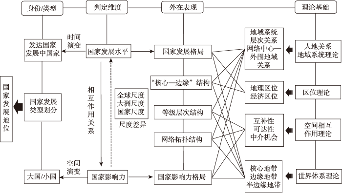
图1
国家发展地位的地理内涵
Fig.1
Geographical connotation of a country's development status
3.2 国家发展地位的分析维度
图2
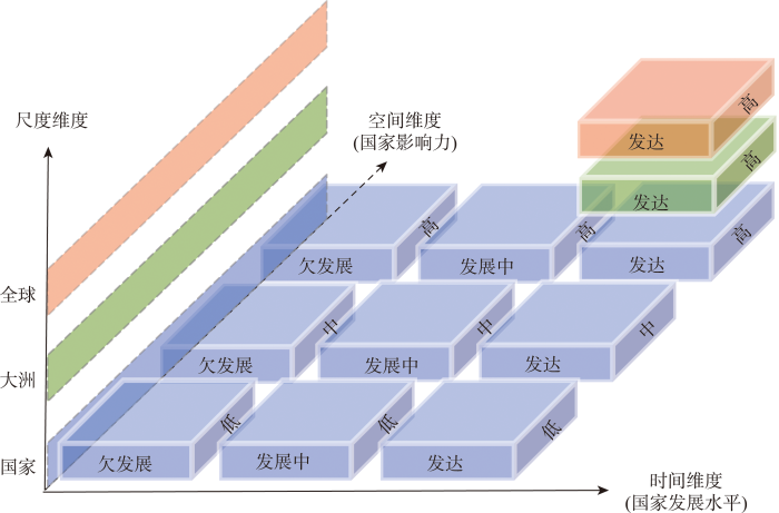
(1) 时间维度主要从国家发展变化的角度出发,认为国家的发展是一个不断变化的动态过程,总体呈现出由“欠发展”逐渐向“发展中”和“发达”演变的过程。发达国家和发展中国家是一对相对概念,属于发展的不同阶段,在发展水平上存在差异[18]。国家发展的动态性特征,决定了不同时期表征国家发展内涵指标的差异性。在国家发展的初期,经济占据绝对的主导地位,社会及环境领域属于从属地位,治理主要服务于经济建设,因此,国家发展初期一般以国民收入、国内生产总值等经济指标来表征国家或地区的发展水平[72-73]。随着国家或地区经济发展水平的提升,发展开始向满足“人”的基本需求转变,兼顾社会、环境及文化的发展,法治、民主参与等治理体系建设逐渐加强,此时健康、教育、收入、人居环境、治理等增强人类福祉的指标成为国家或区域发展的主要表征[74⇓-76]。已有研究指出,当今世界,从关注个人发展的视角出发更能体现国家或地区发展的实际意义,持续保障改善民生、促进人的全面协调发展应成为表征世界各国发展水平的关键指标[9]。
基于上述分析,一个国家或地区的发展可以通过经济、社会、环境、治理等单一发展要素或整体的变化程度来体现。国家或地区的发展一般具备4个方面的属性特征[11,77]:① 综合性,即发展不仅仅是某一方面的发展,而应是经济、社会、环境、治理等多要素的综合协调发展;② 动态性,是指反映国家或地区发展的指标处于不断变化之中,需要对不同阶段的发展要素进行比较;③ 差异性,国家或地区之间的发展要素存在差异性,需对表征发展的不同方面进行比较;④ 相对性,即国家或地区发达与否是一种相对的概念,其结果会随着比较对象的不同而变化。依据经济、社会、文化、环境、治理等多维指标来评估世界各经济体的综合发展水平,可以将世界各经济体划分成发达国家、发展中国家、过渡型国家等多种类型,那么不同类别表征了各经济体在全球体系中发展水平的相对差异程度,这不仅是一种“身份”的象征,也侧面反映了各经济体在全球体系中的发展地位。
(2) 空间维度主要从集聚与扩散的角度出发,认为国家发展是“空间拓展”(或“空间收缩”)的过程,这里的拓展(或收缩)并不是指国家领土的变化,而是强调对外联系的增强或减弱、对其他国家或地区影响力的提升或下降的过程,这种影响体现在与其他国家经济合作、文化交流、环境治理合作、政治联系等多个方面。人文地理学者一般将全球化视为经济、文化、政治等一系列关系在空间上的延展[69]。全球化的持续推进带动了经济、社会、文化以及生态环境的重构,区域不再是一个孤立个体,其意义由其所处的各种关系网络中的“位置”所赋予[78]。因此,网络成为地理学者对关系、国家等要素进行整合分析的重要手段[79]。在当代国际交往中,国家间互动进程主要以和平方式进行,在经济全球化的推动下,经济、社会、文化等非军事化因素的作用逐渐增强,国家对经济主导权的争夺成为当代国际关系的主旋律[80-81]。全球化时代,各国依靠自身的资源禀赋、技术、人力资本等发展要素的相对优势参与到全球化中,每个国家扮演了不同的角色。
世界体系理论中“核心—边缘—半边缘”也是一个国家在世界体系中地位的体现,这种地位是不断变化的[30]。由于国家之间在世界体系中的往来具有关系属性的特征,世界各经济体在经济、文化、政治等领域的相互联系形成了复杂的关系网络,一个国家在复杂网络中扮演的核心或边缘的“角色”是其在世界体系中地位的外在表现。如一个国家在全球贸易体系中的地位,是该国与其他国家贸易联系的一种关系体现,通过测度其在全球或区域贸易网络中与其他国家发生关联的水平(是否有稳定的贸易往来),来判定该国在全球贸易网络中是处于“核心”地位还是“边缘”地位[82]。当一个国家与全球大多数经济体均有经贸往来,且在贸易产品、贸易数量等方面均在与其有往来的经济体中占据很大的比重时,那么其自然处于全球贸易网络的“核心”位置,通过对外贸易来推动本国的经济发展,同时以本国的发展支撑对外经贸发展,进而形成良性互动。相反,当一个国家只与全球少数经济体有经贸往来,且在贸易产品、贸易数量等方面均占很小的比重时,那么其自然被边缘化了,此时该国的经济发展主要受到自身内力的作用。同样道理,从集聚与扩散的视角出发,可以判断一个国家在全球文化交流、全球环境治理合作、全球政治联系等众多领域所形成的复杂网络中扮演的角色,进而综合判定该国在全球体系中的地位及其变化特征。
(3) 尺度维度主要从尺度大小的角度出发,认为一个国家或地区在全球尺度、大洲尺度、国家尺度等不同空间尺度中扮演不同的角色,这也体现了国家发展地位在不同尺度所表现的差异化特征(图3)。空间尺度是研究对象和过程在空间上的表征[76],地理学对空间现象和地理过程的研究首先需要明确空间尺度[83]。刘云刚等[84]从人文地理学视角出发,将尺度归纳为现实尺度、分析尺度和实践尺度三层框架概念体系,其中,现实尺度是客观存在的真实尺度,如全球、地区、城市等;分析尺度是对现实尺度的等级化,是研究者对尺度的认知和运用,如“全球—地方”二级尺度、“全球—大洲—国家—地方”四级尺度等;而实践尺度主要是从尺度政治角度理解,不同主体为了自身的利益利用尺度的相对性作为工具,通过对尺度的争夺来实现利益最大化。按照这一理解,本文中的尺度属于分析尺度的范畴,即主要关注一个国家在全球—大洲—国家三级尺度中所扮演的角色。
图3
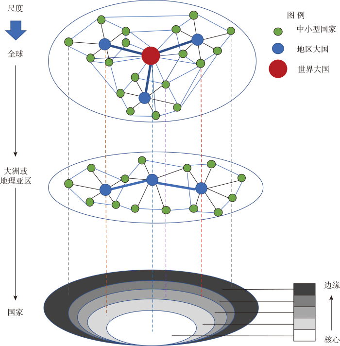
图3
国家在不同尺度联系网络中发展地位示意
Fig.3
Schematic diagram of the development status of countries in contact networks of different scales
全球化使得各种发展要素在全球范围内自由流动,国家之间通过人流、物流、资金流、信息流等在经济、文化、政治等各领域的交互作用形成复杂的关联网络[85-86]。越来越多的学者侧重于从关系与网络的视角出发来理解全球尺度[87⇓-89],使其能够在多尺度下分析同一现象或过程的不同表现[78]。基于这一理解,国家或地区在不同尺度形成了由“点—线—网络”构成的立体网络化的尺度体系(图3)。其中,点代表了国家,其大小代表了国家的身份或地位,如世界大国、地区大国、中小型国家等,是对其他国家经济、社会、文化、政治等多领域影响程度的外在表现。线代表国家之间经济、社会、文化、政治等方面的联系,线的粗细代表了联系程度的大小;由点和线构成了以国家为基本单元的世界联系网络体系。在整个体系中,世界大国处于核心位置,与世界各国交流频繁,在网络等级层次结构中往往扮演主导性节点的角色[41,90]。地区大国一般处于次核心的位置,在所属区域经济、文化、政治等领域发挥重要作用,在世界联系网络的等级层次结构中往往扮演主要节点的角色[44,91];中小型国家的影响力范围有限,在世界联系网络体系中处于边缘、半边缘的位置。国家在不同尺度联系网络中的地位具有尺度差异,如某些地区大国在全球尺度起到支点的作用,但在所属地区可能扮演了主导性节点的角色;再如某些中小型国家在全球或地区层面可能均处于边缘或半边缘的位置,但在国家尺度,对某些特定国家的经济、文化、政治等某一领域的影响力,可能超越其所属的地区大国甚至世界大国的作用。
3.3 融合地理思维的中国发展中大国地位研究的分析框架
图4
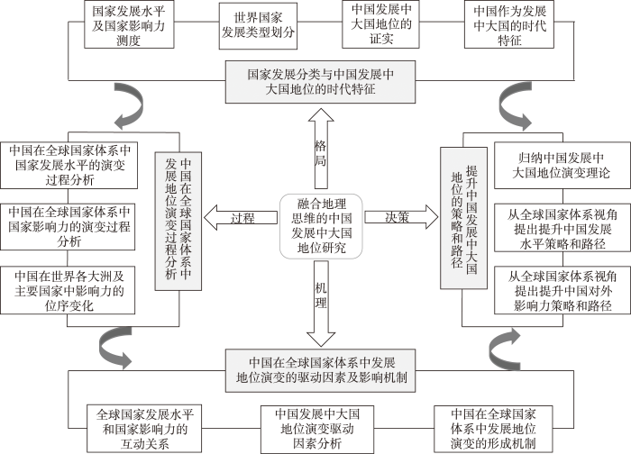
图4
融合地理思维的中国发展中大国地位研究的分析框架
Fig.4
An analytical framework of China's status as a developing great power integrating geographical thinking
(1) 地理格局的探索。世界国家发展类型划分是认识国家发展地位的基础,对不同类型国家发展差异和发展模式的总结有利于形成中国发展中大国地位的认知。融合地理思维构建包括国家发展水平和国家影响力的新分类指标体系和测度模型。通过计算国家发展水平指数和国家影响力指数,确定发展中国家与发达国家阈值以及大国(影响力大)与小国(影响力小)阈值,进而划分出发展中大国、发达大国、其他发展中国家和其他发达国家4个大类。同理,对每个大类进行子类别划分,形成新的世界国家发展类型体系。根据世界国家发展分类结果,证实中国发展中大国的地位,并总结不同类型国家发展差距和发展模式,归纳中国作为发展中大国的时代特征。
(2) 地理过程的探索。地理过程是解析国家发展地位形成机制的关键环节,从地理学视角出发,地理过程可分为时间过程和空间过程2个部分[64]。时间过程和空间过程分析包括中国在全球国家体系中发展地位的变化,以及中国在世界各大洲及世界主要国家中影响力的位序变化。其中,国家发展地位通过发展水平和影响力两个维度来测度,发展水平主要强调国家自身在经济、社会、环境、治理等维度的综合发展水平,影响力则通过中国在经贸往来、文化交流、政治互动、军事合作等多元交流网络中的地位来体现。融入地理思维,采用统计分析和空间分析方法,来揭示改革开放以来中国发展中大国地位的演变过程及特征。
(3) 地位演变机理的探索。全球国家体系是一个复杂的开放系统,某一个国家在全球国家体系中发展地位变化的因素是极其复杂的。从全球地域系统理论角度出发,国家发展水平和国家影响力分别代表两大发展系统,系统之间的非线性综合作用,促使各国在全球国家体系中展现出不同的发展位序、等级层次、核心边缘结构以及差异化的空间影响范围等,进而导致世界各国在全球国家体系中具有不同的发展地位。已有研究从资源禀赋[92]、地理区位[93]等方面探讨了导致全球国家发展水平变化的主要因素;从多维邻近性视角出发分析了全球留学生网络[41]、“一带一路”沿线国家贸易网络[91]的邻近性机理。中国在全球国家体系中发展地位演变机制的研究重点应包括:揭示国家发展地位演变的多要素交互机制,找出影响国家发展水平、国家影响力的主要因素,探讨两者与国家发展地位之间的互动关系;揭示国家发展地位演变的空间(网络)多维邻近性机理,探讨地理、经济、文化、制度等邻近性因素在国家发展地位演变中的交互作用问题。
(4) 地理决策的应用。“格局—过程—机理”探索的最终目的是为进一步提升中国在全球国家体系中的发展地位服务。一方面,需要进一步回答有关“中国是怎样的发展中大国”的一系列问题,包括中国作为发展中大国的事实依据、时代特征、演化过程、主要影响因素及其驱动机制,为对外宣传、制定新时代外交政策等提供素材。另一方面,提出提升中国发展中大国地位的策略与路径,包括重点探讨未来中国对外开放重点关注的区域、重点关注的国家、重点关注的领域,以及提升中国自身发展水平和对外影响力的主要策略和路径。
3.4 中国发展中国家地位论证的实践案例分析
全球尺度的国家分类是论证中国发展中大国地位的重要基础性工作,有学者综合考虑经济、社会、环境、治理等方面的指标,通过构建经济体多维发展水平分类的指标体系,将全球190个经济体划分成发达经济体(含3个子类型)、发展中经济体(含5个子类型)和过渡型经济体3种类型,探讨了不同类型经济体的发展水平特征、中国在全球经济体分类体系中的地位等问题,发现中国属于发展中经济体I型类别,在全球经济体多维发展水平排序、各维度发展水平存在结构差异性等方面具备发展中国家的普遍特征[18],从国家发展水平维度初步论证了中国的发展中国家地位。除此之外,还需对已有分类体系做进一步完善,需结合各经济体经贸联系、人文交流、政治互动、科技合作等方面数据构建国家影响力指数,通过洛伦兹曲线分类法确定国家大与小维度的阈值,然后运用改进象限图法即可识别出国家发达与否、国家大与小双重维度的国家类型组合(图5)。据此,可以识别出发达大国、发展中大国、其他发展中国家、其他发达国家等多个大类及相应的子类别。由于大国与小国之间的可比性较差,通过新的分类体系构建,能够识别出发达大国与发展中大国,这样有利于梳理中国和发展中大国的共性特征及其与发达大国的差距,进而有助于总结中国作为发展中大国的时代特征。
图5
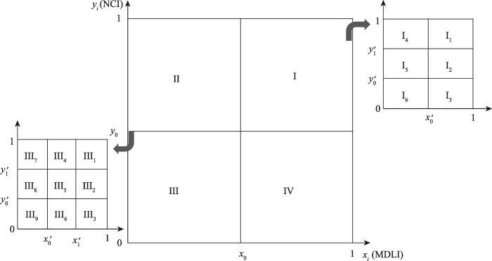
图5
基于改进象限图法的国家分类示意图
注:MDLI为多维发展水平指数,NCI为多元影响力指数,i为研究单元数量。x0是发达与否的阈值,可将研究的所有国家分为发达国家(阈值区间为x0<xi≤1)和发展中国家(阈值区间为0<xi≤x0);y0是大国与其他国家的阈值,可将研究的所有国家分为大国(阈值区间为y0<yi≤1)和其他国家(阈值区间为0<yi≤y0)。据此,可得到I(发达大国)、II(发展中大国)、III(其他发展中国家)和IV(其他发达国家)4种类型。x0′、x1′分别为对应的子类别国家多维发展水平指数的阈值,y0′和y1′分别为对应的子类别国家多元影响力指数的阈值。两个维度具体分类数量的确定方法及阈值计算的方法详见文献[18]。
Fig.5
Schematic diagram of country classification based on the improved quadrant diagram method
4 结语与讨论
4.1 结语
中国发展中大国地位研究是一个复杂的、涉及多学科的综合性课题。中国是怎样的发展中大国?对这一问题的科学回答是决定中国在世界的定位及发展策略的重要依据。国内的国际关系学、国际政治经济学等学科学者从各自学科特点出发对中国发展中大国的身份和属性进行了论证,但缺乏融合地理学的综合性、地域性和时空及尺度思维的研究。本文系统梳理了发展中大国地位相关研究进展,总结了已有研究存在的不足之处;重点阐述了国家发展地位的地理学基础理论的核心要点及其对国家发展地位研究的考量。在此基础上,提出了国家发展地位的地理内涵,并从时间、空间和尺度3个维度对其进行了解读。最后,结合“格局—过程—机理—决策”的地理学经典研究范式,提出了融合地理思维的中国发展中大国地位研究的分析框架。该框架有助于归纳国家单元在全球体系中地位的演变规律,了解国家个体在全球多元联系网络及层级结构中扮演的角色,根据自身发展水平和影响力承担相应的国际责任。这一框架可为中国发展中大国地位的综合判定、如何更好地开展“一带一路”建设、更好地发挥中国在全球治理体系中的地位等论题提供参考和借鉴。
4.2 讨论
(1) 国家分类是判定中国发展中大国地位的重要基础性工作。国家分类体系是从全球整体认识各个国家发展地位的基础,世界银行、联合国开发计划署、国际货币基金组织等国际机构出于相关业务的需要最早开展了国家发展类型的划分,随后国外学者针对国家发展分类的维度、指标、方法进行了发展和完善,相比之下,国内学者对此关注明显不足。地理学的综合性、地域性、时空及尺度思维等学科特性可为国家分类及中国发展中大国地位研究提供理论和方法支撑,今后的研究重点应包括国家分类的综合指标体系的构建、分类维度和方法的探索、发达国家与发展中国家阈值区间的确定等。在此基础上,关键在于通过分类找出发展中国家的共性特征,发达国家与发展中国家在经济发展模式、社会发展特征、发展水平或影响力的时空过程等方面的差异,总结出中国作为发展中大国的特征,分析中国与发达国家(尤其是发达大国)之间的发展差距,包括从人均水平比较的视角,从国家内部区域之间发展不平衡的视角,从国家发展水平与对外经济、社会、文化、政治影响力匹配的视角等。
(2) 地域差异与地域联系是从地理学视角开展中国发展中大国地位研究的重要主线。地域差异主要从自然要素、人文要素、经济要素等地域系统发展基础方面出发,通过类型划分,总结不同类型经济体之间发展水平、发展模式差异,来判断中国的全球位序。地域联系主要从生产要素的全球流动视角出发来解释中国在全球体系中的地位变化,地域联系包括全球与地方的联系、不同类型经济体之间的联系,这里涉及全球一体化与区域一体化整合的问题。生产要素流动是地域联系的动力,经济全球化形成了全球价值链的分工体系,将生产过程分割成精细化、专业化等不同模块,跨国公司依赖于经济、文化、技术等多元要素流动来塑造全球网络,反映在地理上就是网络层级结构,以此来构造世界的核心—边缘结构,进而影响国家(经济体)在全球体系中的地位。处于不同发展阶段的国家或地区,依据各自的自然资源、人力资源、科技资源等要素禀赋参与到全球价值链分工当中,进而塑造了全球时空版图[94]。中国通过自身资源禀赋、劳动力资源优势和制定开放的政策,融入全球价值链分工体系当中,凭借廉价的劳动力成本优势发展成为“世界工厂”,不仅推动了中国经济社会的发展,还提升了中国在全球国家体系中的经济影响力。但中国在全球价值链分工中处于中低端位置,在关键和核心技术方面受制于发达国家,经济全球化和全球价值链分工体系在促进中国经济社会发展的同时,也奠定了中国作为发展中大国的国际地位。改革开放以来,中国快速融入全球环境体系、全球经济一体化体系、全球地缘政治结构变化的博弈中,中国等发展中大国如何维护在现有的全球体系(政治体系、经济体系)中的权益问题,从产业链角度如何从低级要素的过度供给地位向高级稀缺性要素供给转变的问题等一系列问题有待进一步探索。
致谢
非常感谢匿名评审专家对文章有关逻辑框架、大国判定标准等方面提出的宝贵意见。
参考文献
中国的世界地理研究进展与展望
[J].
Retrospect and prospect of world regional geography in China
DOI:10.11820/dlkxjz.2011.12.008
[本文引用: 1]

Based on a review on works of world regional geography accomplished in China during the past 10 years and an analysis of its current problem, the research orientation for further sustained development of the discipline is discussed in this paper. Accompanied by a rapid rise of China, the fields of world regional geography in China have expanded from pure geography research on regions and countries outside China to including the study of global economy and political geography in its quest to satisfy the need of the national development. The major concerns of world regional geography researchers in China in recent years include: (1) research on world geopolitics and geo-economy, e.g. geopolitics-related theories, changing tendencies of geopolitical situations in given places across the world and some hot spots and impacts that geopolitical situations of the powers and surrounding regions have on China; (2) geographical research on international investment and multinational corporations, focusing on theories and mechanism of outward investment, spatial distribution and location determination of foreign investments in China, and analyses of investing scales, modes and performance; (3) theoretical and empirical research on the development of cities and regions in the world, highlighting the researches on laws of formation and mechanism of megalopolis and urban agglomerations around the world and empirical research on major cities in some countries such as USA, Japan, UK and France. The theoretical and empirical research on foreign regions revolves around the theory and practice of“new regionalism”, new regional division of labor, regional interaction and sustainable regional development; (4) research on global resources and environmental protection and conservation, focusing on the exploitation, development and utilization of global natural resources. The most serious one is the issue of energy, which is the main subject of much related research. On the basis of the above points, the authors point out the problems emerging in the development of world regional geography as a discipline in China, such as ineffective research team, insufficient research funds and poor research abilities, as well as differences between China and other countries in this area. Finally, the paper comes to the conclusion that the golden age of world regional geography research in China has arrived, therefore, it is necessary to enhance special research on critical global issues such as geopolitics and geo-economy. Thus, it is imperative to follow through the world geography research plans, such as the comprehensive research on countries and regions closely related to China in the areas of the developing trends of world economy, politics, science and technology and strictly conform with the objectives to implementing the important strategies for national development.
今天的中国为什么比任何时候都需要世界地理学
[J].
DOI:10.3969/j.issn.1004-9479.2020.01.2019801
[本文引用: 1]
世界地理作为中国地理学的重要分支学科,特指研究中国以外区域或国家的地理学科,是中国特有的学科分类现象。中国地理学的这种内外有别的思想对世界地理发展危害甚大,至今都难以消弭。忽视世界地理研究,就会有只见树木、不见森林之虞。为了贯彻落实党的“十九大”精神,繁荣探索新型科研组织机制,打造一流世界地理学科,服务国家重大国际战略需求,来自国内高校、科研院所的百余人齐聚一堂,探讨中国世界地理学科发展之路。与会专家一致认为:地理学是国家发展的法宝,是立国之本。当前世界政治经济格局加速重构,为中国地理学发展带来了前所未有的历史机遇,也赋予地理学特别是世界地理学学科新的重大历史使命。为此,须充分发挥地理学科的优势和特长,紧跟国家和世界发展大势,树立全球眼光,面向国家重大战略需求,把自然与人文结合起来,面向可持续发展,团结国内各相关单位,进行跨学科研究,提升世界地理学科为二级学科,构建具有中国特色的世界地理学理论体系、逻辑框架和学科范式,提升中国地理学科,特别是世界地理学科服务国家和地方发展的能力。
Why does China today need world geography more than ever
DOI:10.3969/j.issn.1004-9479.2020.01.2019801
[本文引用: 1]
As an important branch of China’s geography, world geography refers to the geographical study on regions or countries outside China, which is a special phenomenon of discipline classification in China. This idea that China’s geography has significant difference from China to outside China has done great harm to the development of world geography, which has been difficult to eliminate till now. Ignoring the study on world geography will impose limitations on research horizons, just like seeing partial trees rather than entire forests. In order to implement the spirit of the 19th National Congress of the Communist Party of China, prosperously explore new organization mechanisms of scientific research, create the first-class world geography discipline, and serve the needs of the country's major international strategies, more than 100 experts from domestic universities and research institutes gather to discuss the way to the development of China's world geography. The experts agree that geography can be regarded as the foundation of the country and a magic tool of national development. The accelerated reframing of the current world political and economic structure has brought unprecedented historical opportunities for the development of China’s geography, and has endowed geography, especially world geography with the new major historical missions. To this end, it is necessary to give full play to the advantages and specialties of geography, keep up with the development trend of the country and the world, establish a global perspective, face the needs of major national strategies, combine nature and humanities, face sustainable development, unite relevant domestic units to conduct interdisciplinary research, aiming at lifting world geography to a second-level discipline, building up a theoretical system, logical framework and disciplinary paradigm of world geography with Chinese characteristics, and improving the capability of China’s geography, especially world geography, to serve national and local development.
The limitations of the special case
[J].
Economic development with unlimited supplies of labour
[J].DOI:10.1111/j.1467-9957.1954.tb00021.x URL [本文引用: 1]
The meaning of development
[J].
A physical quality of life index
[J].DOI:10.1016/0304-4009(78)90015-3 URL [本文引用: 1]
Governance matters iii: Governance indicators for 1996-2002
[R].
区域多维发展综合测度方法及应用
[J].
DOI:10.11821/dlxb201612005
[本文引用: 3]
借鉴国内外区域发展研究从单要素、单指标走向多要素、多指标综合测度的学术思路,从收入、消费、教育、人口城镇化、交通及生活设施等6个维度选择了12个指标,建立了多面体法区域多维发展综合测度方法及模型,改建了适用于区域多维发展综合测度的多边形法和向量和法定量模型,并与已得到广泛应用的加权求和法一起按县级、地级和省级单元对中国的区域多维发展状况进行了综合测度实证研究。结果表明:不同维度单项指标值和区域多维发展指数在全国各县级单元之间存在着显著差异;区域多维发展指数在空间分布上呈现出东部沿海高、中部及北方沿边地区中等、西南及西部沿边地区低的基本格局,高和较高类型区主要分布在东部沿海、中西部城市以及能矿资源开发地区,低和较低类型区基本上与国家新认定的集中连片贫困区的分布一致;按县级、地级和省级不同尺度单元,借助SPSS和EXCEL软件对4种方法测算结果的相关性分析表明,多面体法、多边形法、向量和法、加权求和法在实际应用中具有等效性,选用任何一种方法都能达到区域多维发展综合测度和评价的目的。
Comprehensive measure methods of regional multi-dimensional development and their applications
DOI:10.11821/dlxb201612005
[本文引用: 3]
Regional development researches at home and abroad have the trend of single factor and index towards multi-factor and multi-index comprehensive measure. Using the academic thought for reference, this paper selected 12 indices from 6 dimensions, including income, consumption, education, urbanization of population, traffic and living facilities. Polyhedron method was put forward to comprehensively measure regional multi-dimensional development level. Polygon method and vector sum method were improved for being more suitable for studying regional multi-dimensional development status. Regional multi-dimensional development level by county, city and province in China was measured comprehensively and its spatial difference was analyzed by using the above three methods as well as the weighted sum method applied widely. The study found that at the county level there was remarkable regional difference in the single-index values of different dimensions and regional multi-dimensional development index. Regional multi-dimensional development index was high in the eastern coastal areas, medium in the central region as well as the northern border regions and low in the southwest as well as the western border regions. Districts characterized by the levels of high and very high were distributed in the eastern coastal areas, cities of the central and western regions as well as the areas of energy and mineral resource development. Distribution tendency of the districts featured by the levels of low and very low was in accordance with that of the poverty-stricken areas. Correlation analyses of four methods’ results were conducted by SPSS and Excel at the province, city and county level respectively. The results showed that the four methods were equivalent in the practical application. They all could be used for regional multi-dimensional development measure. Correlation analysis between multi-dimensional development index calculated by the polyhedron method and GDP per capita indicated that the latter could not represent the level of regional multi-dimensional development.
How are the income group thresholds determined?
[EB/OL]. 2014-07-01 [2021-05-31]. https://datahelpdesk.worldbank.org/knowledgebase/articles/378833-how-are-the-income-group-thresholds-determined.
国际组织关于发达国家和发展中国家的界定
[J].
Definition of developed countries and developing countries by international organizations
The income lever and the allocation of aid
[J].DOI:10.1080/00220388.2014.951037 URL [本文引用: 1]
Classification of nations as developed and less developed: An arrangement by discriminant analysis of socioeconomic data
[J].DOI:10.1111/ajes.1983.42.issue-2 URL [本文引用: 1]
Revisiting the meaning of development: A multidimensional taxonomy of developing countries
[J].DOI:10.1080/00220388.2013.822071 URL [本文引用: 1]
中国发展中国家地位的论证: 基于190个经济体多维发展水平分类的实证分析
[J].
DOI:10.18306/dlkxjz.2022.10.009
[本文引用: 5]
科学判断一个国家在全球体系中的地位是制定外交政策的基础。目前中国的发展中国家地位遭到了西方国家的质疑,国内学者从国别比较等视角出发论证了中国的发展中国家地位,但缺乏从全球尺度分类视角的回应。论文基于多面体法、洛伦兹曲线分类法等方法,从经济、社会、环境、治理等方面构建经济体的多维发展水平分类指标体系和测度模型,将全球190个经济体划分成发达经济体Ⅰ~Ⅲ型、发展中经济体Ⅰ~Ⅴ型和过渡型经济体共9种类型,并探讨了不同类型经济体的发展水平特征、中国在全球经济体分类体系中的地位等问题。研究发现:① 不同类型经济体在经济、社会、环境、治理等分维度发展水平方面具有显著的差异性。② 发达经济体各维度发展水平排名普遍较高,总体呈现“并驾齐驱”特征;过渡型经济体在很多维度的发展指标与发达经济体Ⅲ型接近,多数经济体处于逐渐向发达经济体过渡的发展阶段;发展中经济体在分维度发展水平方面存在显著的结构性差异。③ 中国属于发展中经济体Ⅰ型类别,在全球190个经济体中排在第64位,在139个发展中经济体中排在第13位。④ 中国在全球经济体多维发展水平排序、各维度发展水平差异等方面具备发展中国家的普遍特征。该研究洛伦兹曲线分类法等方法的应用可丰富区域发展分类理论,相关结论可为回击西方国家对中国发展中国家地位的质疑提供借鉴。
Demonstration of China's status as a developing country: An empirical analysis based on the multi-dimensional development level classification of 190 economies
DOI:10.18306/dlkxjz.2022.10.009
[本文引用: 5]
The scientific evaluation of a country's position in the global system is the basis for formulating foreign policies. At present, China's status as a developing country has been questioned by Western countries. Chinese scholars have demonstrated China's status as a developing country by country comparison, but lacked a response from the perspective of global scale classification. Based on the polyhedron and the Lorentz curve classification methods, this study constructed an indicator system and measurement model for the classification of development level of economies from multiple dimensions including economy, society, environment, and governance, and further divided 190 economies around the world into developed country types I-III, developing country types I-V, and transitional economies, at nine types. Moreover, it discussed the development characteristics of different types of economies and China's status in the global country classification system. The results show that: 1) There are significant differences in the development levels of different types of economies in the dimensions of economy, society, environment, and governance. 2) The development level of developed economies is generally high in all dimensions, showing the characteristics of "keeping abreast" in general; the development indicators of transitional economies in many dimensions are close to that of developed economy type III, and most economies are in a development stage that is gradually transitioning to developed economies; Significant structural differences exist in developing economies in the level of sub-development dimensions. 3) China belongs to the developing country type I, ranked 64th among the 190 economies and 13th among the 139 developing countries. 4) China has the general characteristics of developing countries in terms of the ranking of the multi-dimensional development level among the global economies and the differences in the development level of various dimensions. The application of the Lorenz curve in this study can enrich the theory of regional development classification, and the conclusions can provide a reference for countering Western countries' doubts about China's status as a developing country.
Power analysis and world politics: New trends versus old tendencies
[J].
DOI:10.2307/2009941
URL
[本文引用: 2]
Recent refinements in social science thinking about power could be used to revitalize this approach to understanding international relations. The relevance of scholarly work on the causal concept of power is explored with regard to the following topics: potential vs. actual power, interdependence, military power, positive sanctions, the zero-sum model of politics, and the distinction between deterrence and compellence. The tendency to exaggerate the fungibility of power resources, the propensity to treat military power resources as the1 “ultimate” power base, and the emphasis on conflict and negative sanctions at the expense of cooperation and positive sanctions, are still common in international relations scholarship. The most important need is for recognition that the absence of a common denominator of political value in terms of which different scopes of power can be compared is not so much a methodological problem to be solved as it is a real-world constraint to be lived with.
The modes of China's influence: Cases from Southeast Asia
[J].
DOI:10.1525/as.2014.54.5.825
URL
[本文引用: 1]
Distinguishing between power as resources and influence as converting those resources into outcomes, I propose a new framework for analyzing China’s influence, using examples from Southeast Asia. Because China exercises influence predominantly in contexts of convergent, not divergent, preferences, three key modes of influence are “preference multiplying,” “persuasion,” and “ability to prevail.”
发展中大国的战略作用
[J].
The strategic role of big developing countries
大国地缘战略交汇区的时空演变: 特征、规律及其原因
[J].
DOI:10.13284/j.cnki.rddl.003196
[本文引用: 1]
采用文本分析和空间可视化方法,对1900年以来世界主要大国不同时期地缘战略进行分析,结果表明:1)大国地缘战略交汇区时空演变呈现欧亚大陆主导、集中于边缘新月形地区和环中国周边分布的空间特征;2)交汇区形成了从分散到集中、陆海兼备、部分区域稳定和“低政治化”趋势的演变规律;3)国家利益、资源需求、地区历史和复杂宗教问题以及国际体系的变迁是地缘战略交汇区形成的重要原因。最后提出加强海军建设,弱化地缘战略交汇区域集中趋势,在地缘战略交汇区内集中经济竞争等建议,为中国应对国际局势的变化提供参考。
Temporal and spatial evolution characteristics and laws of geostrategic intersections in great powers
DOI:10.13284/j.cnki.rddl.003196
[本文引用: 1]
Since the end of the 20 th century, the world has considerably changed considerably. Great countries are formulating and constantly adjusting their country's geostrategic strategies in response, promoting the formation of a classic and modern geostrategic strategy. However, research regarding the spatial-temporal evolution of geostrategic intersections is limited. Therefore, it is of great theoretical and practical significance to explore the characteristics and laws of the spatial-temporal evolution of geostrategic intersections and analyze their origins. Using text analysis and spatial visualization methods, seven major world powers are selected according to comprehensive and industrial indicators. Their geostrategic strategies during different periods since 1900 are analyzed. The results show that the spatial and temporal evolution of the geostrategic intersections of large countries shows three distinct characteristics: the spatial and temporal evolution of the geostrategic intersections of the great countries is characterized by the spatial characteristics of the Eurasian continent, concentrated in marginal crescent-shaped regions, and spatially distributed around areas surrounding China. At the same time, the temporal and spatial evolution of the intersections also followed three evolutionary laws, including the transformation from dispersion to concentration and the occurrence of ocean-continent intersections, partial regional stability, and a“low politicization” trend. Following an analysis of the reasons driving the evolution of intersections, it is found that national interests, resource needs, regional histories, and complex religious issues as well as changes in the international system are important reasons for the formation of geostrategic intersections. Finally, suggestions such as strengthening naval capabilities, weakening the trend of concentration in geostrategic intersections, and concentrating the power of economic competition in geostrategic intersections are proposed to provide a reference for China to address changes in the international situation.
如何科学界定当代中国的国际地位?
[J].
How to scientifically define the international status of contemporary China?
中国国际地位动态研究(2008—2018)
[J].
Dynamics of China's international status (2008-2018): A comparative analysis
中美在南亚地缘影响力的时空演变及机制
[J].
DOI:10.11821/dlxb201506002
[本文引用: 1]
南亚是中美两国重要的地缘战略区,无论是对中国海上运输的安全和西部边疆的稳定,还是对美国实施“亚太再平衡”战略,都有着十分重要的作用。如何解析中美在南亚地缘影响力的变化及演变机制,是需要解决的关键科学问题。结合地理学、国际关系学和政治学研究视角,采用数学建模方法,构建国家地缘影响力的指标体系和模型,选取南亚为研究区域,探讨中美在南亚地缘影响力的时空演变,探寻地缘影响力演变的影响因素以及驱动机制。结果表明:① 近10年,中美在南亚的地缘影响力在小幅波动中呈逐年上升趋势。从增幅比率看,中国在南亚地缘影响力的增速要比美国快。② 国家地缘影响力演变是一个缓慢过程。2003-2012年间,中美在南亚国家和地区的地缘影响力变化幅度不大。③ 硬实力、软实力、相互依赖力和摩擦力是地缘影响力演变的主要影响因素。其中,硬实力和软实力是主导因素,起拉力作用;相互依赖力是辅助因素,起推力作用;而摩擦力是弱化因素,起反向力作用。④ 中美在南亚地缘影响力演变的驱动力包括地缘区位、地缘政治、地缘经济和地缘文化。地缘区位是国家地缘影响力演变的制约力,地缘政治是主导力,地缘经济是驱动力,地缘文化是辐射力。⑤ 国家硬实力不等于地缘影响力,国家硬实力强并不能代表其对外的地缘影响力就高,两者是非线性关系。硬实力虽起主导作用,但不能决定地缘影响力变化的强度和速度。
The spatio-temporal evolution and driving mechanism of geopolitical influence of China and the US in South Asia
DOI:10.11821/dlxb201506002
[本文引用: 1]
As a vital geo-strategic area for China and the US, South Asia plays an important role in international geopolitics. On one hand, China's maritime transportation safety and the stability of western frontier are closely related with South Asia. On the other hand, the US needs to implement "Asia Pacific rebalancing strategy" by means of the support of South Asia. Therefore, how to analyze the changes and evolution mechanism of geopolitical influence (i.e., geo-influence) of China and the US in South Asia, has become the key research question. This paper proposes the index system and mathematical model of geo-influence by combining geography, international relations and political perspective. Furthermore, the paper explores the main influencing factors and driving mechanism of geo-influence evolution by analyzing the spatio-temporal changes of geo-influence of China and the US in South Asia. In this study, five results can be concluded as follows: (1) The geo-influence of China and the US in South Asia has been rising slowly with small fluctuations from 2003 to 2012. What’s more, the geo-influence of China grew faster than that of the US. (2) The evolution of national geo-influence is a slow process. From 2003 to 2012, the changes of geo-influence of China and the US in South Asia fluctuated within a narrow range. (3) Hard power, soft power, interdependent power and friction force are the main effect factors of geo-influence. Hard power and soft power are the dominant factors, which play a pulling role. Interdependent power is the auxiliary factor, which plays a pushing role. Friction force is the weakening factor, which plays a reversing role. (4) The driving mechanism of geo-influence evolution of China and the US in South Asia involves geographical location, geopolitics, geo-economy and geo-culture. Among them, geographical location acts as the restricting force; geopolitics acts as the leading force; geo-economy acts as the driving force; geo-culture acts as the radiate force. (5) National hard power is not equal to the geo-influence. One strong country does not necessarily have the same strong geo-influence. Thus there is a non-linear relationship between national hard power and geo-influence. Hard power does play a leading role, but it cannot determine the strength and speed of geo-influence changes.
中美日印对中南半岛国家影响力的测度与分析
[J].
Influence on the Indo-China Peninsula: A comparison of China, the US, Japan and India
发展地理学研究进展与展望
[J].
DOI:10.11821/dlxb202002002
[本文引用: 3]
本文回顾和总结了20世纪以来发展地理学的研究进展,涉及发展地理学内涵和理论、领域和方法及其发展趋势。系统梳理了发展地理学在欠发达国家或地区发展收敛、发达地区或国家生活品质提升过程中的收敛及其路径等研究内容。通过分析国外研究进展,指出了发展地理学在中国的发展条件与学科优势,并着眼于国际学术前沿最新动向与国家宏观战略需求,提出了今后中国发展地理学研究需重点关注的领域。未来发展地理学研究应以可持续发展理论为指引,以提升欠发达地区可持续生计能力与区域绿色发展水平为核心,以构建发展地理学理论和跨学科综合集成研究体系为目标,聚焦区域发展的空间格局、扩散特征与收敛研究,探索出服务于区域经济建设与产业发展的调控政策与科学路径。
Research progress and prospect on development geography
DOI:10.11821/dlxb202002002
[本文引用: 3]
In this paper, we review and sort out research progress on development geography since the 20th century, involving its connotation and theory, fields and methods, and development trends in this paper. Specifically, we systematically reviewed the research and application of development geography in the fields such as in the convergence of underdeveloped countries or regions, the convergence in the process of improving the quality of life in developed countries or regions. Then, in line with the analysis of the research progress on development geography in foreign countries, we indicate the development conditions and disciplinary advantages of development geography in China. Further, we pointed that future development geography research in China should focus more on the latest international academic frontier research and national macro-strategic needs. The future research of development geography should be guided by the theory of sustainable development, with the core of improving the sustainable livelihood capacity and regional green development level in underdeveloped areas, and aiming at constructing industrial policy and development geography theory and interdisciplinary integrated research system, and focusing on research on the spatial pattern, diffusion characteristics and convergence mechanism of regional development, to explore the regulatory policies and scientific paths that serve regional economic construction and industrial development.
Order in Asia beyond power transition: Understanding China's rise, changing international roles and grand strategies
[J].
对中国“发展中国家”地位的再认识
[J].
Recognition of China's status of "developing country" and relevant issues
中国发展中国家地位及其变化趋势: 基于美国和韩国的比较研究
[J].
The status of China's developing countries and its changing trends: Based on comparative studies between the United States and South Korea
为什么中国“发展中国家”的身份会成为一个问题
[J].
Why is China "developing China's status" will become a problem
Tailoring for development: China's post-crisis influence in global financial governance
[J].DOI:10.1111/gpol.2018.9.issue-4 URL [本文引用: 2]
China and the IMF: From mimicry towards pragmatic international institutional pluralism
[J].DOI:10.1111/inta.2013.89.issue-4 URL [本文引用: 1]
全球留学生留学网络时空演化及其影响因素
[J].
DOI:10.11821/dlxb202004002
[本文引用: 3]
基于联合国教科文组织公布的全球高等学校留学生流动数据,借鉴网络科学,利用社会网络分析方法和负二项回归模型,对2001—2015年全球留学网络时空演化及其影响因素进行研究。主要结论为:① 时序演化特征上,全球留学网络关系流从4921个增加到9137个,平均加权度从8004迅速增加到20834,表明全球留学网络不仅学生数量在增加,且留学路径数量也在不断增加。② 拓扑结构上,从以美国为单一核心,演变成以美国、中国为双核心的拓扑结构,亚洲国家逐渐成为全球留学网络的主体,欧洲国家的中心性逐渐萎缩。③ 空间结构上,全球留学网络具有明显的等级层次性,美国是全球性主导型节点,德国、捷克是区域性主导型节点,次级主导型节点从25个增加到32个,全球留学网络“东向西、南到北”的地理空间格局正在发生变化,中国、澳大利亚等国成为新的区域性中心,区域化成为全球留学网络一个重要趋势。④ 回归分析发现,留学目的地国高等教育质量、高校在校生数量、人均GDP、留学目的地国与留学生来源国间的历史联系及全球化水平与留学生流量呈显著正相关关系,地理距离、语言临近性与留学生流量呈显著负相关关系,表明语言差异的阻抗作用在迅速减弱,地理距离仍然是阻碍学生流动的一个重要因素。
Spatio-temporal evolution and factors influencing international student mobility networks in the world
DOI:10.11821/dlxb202004002
[本文引用: 3]
Based on the data released by UNESCO on international student mobility in tertiary education from 2001 to 2015, this paper draws on network science to construct a multidimensional weighted directed network heterogeneity model. This model combines the GIS spatial analysis method and the negative binomial regression model to study spatiotemporal evolution and factors influencing international student mobility networks. The results are as follows. First, in terms of the evolutionary characteristics of time series, the linkages of international student mobility networks have increased from 4921 to 9137, and its average weighted degree centrality has rapidly increased from 8004 to 20,834, which indicates that both the number of international students and the choices of overseas routines are mounting. Second, in terms of the topological structure, it has evolved from a single core comprising the United States into dual cores comprising the United States and China. Gradually, Asian countries have become the main body of international student mobility networks, while the centrality of European countries has reduced. Thirdly, in terms of spatial structure, the international student mobility network has a significant core-periphery structure and hierarchical characteristics. The countries in the core, strong semi-periphery and semi-periphery alternate with countries from other tiers. The spatial patterns of the international student mobility network "from east to west, and from south to north" are changing. China and Australia have become the new regional centers of international student mobility networks, meaning that regionalization has become an important trend. Finally, regression analysis shows that the flow of international students correlates positively with the quality of higher education in destination countries, the number of students in colleges and universities, the per capita GDP, the historical links connection between the destination country and the country of origin, and the level of globalization. Geographical distance and linguistic proximity have a significant negative correlation with the flow of international students, indicating that the impediment of language is rapidly weakening, while geographical distance still hinders student mobility.
“一带一路”贸易网络与全球贸易网络的拓扑关系
[J].
DOI:10.18306/dlkxjz.2017.11.003
[本文引用: 1]
共建“一带一路”倡议致力于建设开放型经济、确保自由包容性贸易。本文基于社区发现法、拓扑网络可视化等方法,对比分析“一带一路”贸易网络与全球贸易网络的拓扑关系,明确其贸易在全球的地位,以期为“一带一路”自由包容性贸易体系建设提供科学支撑。研究发现:①全球贸易网络可以识别出5个组团,其核心节点分别是中国、美国、德—荷—法—英等欧洲发达国家、俄罗斯、印度—阿联酋。②“一带一路”沿线可以识别出3个主组团及2个次组团,其中,亚欧大组团以中国为核心、俄罗斯为次核心,南亚—西亚组团以印度、阿联酋、沙特阿拉伯为核心。③在全球贸易网络中,大部分沿线国家仍被中国、俄罗斯、印度—阿联酋等核心节点所吸引,且与“一带一路”沿线的贸易联系较强;中东欧国家主要被德—荷—法—英等西欧国家核心节点所吸引,是“一带一路”低渗透国家;部分东南亚国家虽然被吸纳到以中国为核心的亚澳—南非组团,但与“一带一路”贸易联系还需加强。
Topological relationship between trade network in the Belt and Road Initiative area and global trade network
DOI:10.18306/dlkxjz.2017.11.003
[本文引用: 1]
Unimpeded trade is one of the priorities of cooperation in the Belt and Road Initiative proposed by China. On 15 May 2017, the Joint Communique of the Leaders Roundtable of the Belt and Road Forum for International Cooperation reaffirmed the participants' shared commitment to build an open economy and ensure free and inclusive trade. The Belt and Road Initiative (BRI) is not only China's new action to drive its open and global development, but also a platform for increasingly more countries to explore free and inclusive trade. It is therefore important to examine the topological relationship between BRI trade network and global trade network, for promoting a universal, rule-based, open, nondiscriminatory, and equitable multilateral trading system. Based on a literature review, this article first analyzes community structure and trade network based on community detection algorithm, and then estimates the topological relationship of different trade communities. The findings of this article are as follows. First, we identified five trade communities in global trade network through community detection algorithm, in which China, USA, Russia, India-UAE, and Germany-the Netherlands-France-Britain and other European developed countries are the cores of the five trade communities, respectively. Second, we identified three trade communities and two sub-communities in the BRI trade network, in which China is the core, Russia is the sub-core of the biggest trade community, and India, UAE, and Saudi Arabia are cores of the second trade community (South Asia-West Asia). Third, the topological analysis results indicate that in the global trade network, most BRI countries are attracted by the core nodes in the BRI area, such as China, Russia, India-UAE core nodes, and have strong trade contact with BRI countries. Most Central-East European countries are mainly attracted by Germany-the Netherlands-France-Britain and other European developed countries with low penetration of BRI trade. Although some Southeast Asian countries are incorporated into the Asia-Australia-South Africa community with China as the core, they still need to strengthen trade linkages with BRI countries.
地缘战略视角下“一带一路”倡议对中国对外直接投资的影响研究
[J].
Impact of the Belt and Road initiative on Chinese OFDI: A geopolitical strategic perspective
“一带一路”沿线国家科研合作网络的多元结构及形成机制
[J].
DOI:10.11821/dlyj020190376
[本文引用: 2]
科技合作是“一带一路”倡议“民心相通”的重要组成部分,2013年以来取得显著进展。以“一带一路”沿线65国为研究区,运用WOS核心集合论文合作数据构建国家间科研合作矩阵,通过GIS空间分析、社会网络分析以及负二项回归分析法,探究沿线各国2013年和2018年科研合作网络的多元化结构及形成机制,结果表明:① 在全球尺度,“一带一路”沿线各国与其他国家之间的知识流动日趋频繁,但内部合作紧密程度不及与沿线以外地区的合作程度。沿线区域对全球的科研合作网络由欧洲、美国和中国“三足鼎立”骨架结构向欧洲、美国、中国、加拿大、日本、澳大利亚等多个密集区构成的“多边形”骨架结构转变。② “一带一路”沿线地区的合作网络的空间结构,由中国、中东欧区组成的“双核发散”向“一区多点”构成的“多极化”空间结构转变;等级结构则呈现典型的“中心-外围”等级层次结构,且由单核心向双核心转变;控制结构呈现出由“单核心”向四周高、中间低的“多超多强”盆地型控制结构转变。③ 沿线国家的科研实力、经济发展水平、对外开放度等国家主体属性以及地理邻近性、社会邻近性等是沿线科研合作网络形成的主要机制,其中科研实力、社会邻近性的作用最大,地理距离对科研合作的阻碍作用逐渐减弱。
The multiple structure and formation mechanisms of the scientific collaboration network in the Belt and Road regions
DOI:10.11821/dlyj020190376
[本文引用: 2]
<p id="C3">Scientific collaboration has become an important part of the people-to-people exchanges in the Belt and Road Initiative, and remarkable progress has been made since 2013. Taking the 65 countries in the Belt and Road regions, hereafter called the BRI countries, as the research areas and using the collaborated WOS core collection papers to construct the inter-national scientific collaboration matrix, the paper explores the multiple structure and formation mechanisms of the scientific collaboration network of BRI countries through the GIS spatial analysis, social network analysis and negative binomial regression. The results show that: (1) at the global scale, knowledge flow is becoming more and more frequent, and the degree of internal collaboration within BRI countries is not as close as that of collaboration with other countries in the world. All the sub-regions of BRI regions have the most external collaboration links with Europe outside BRI regions. The global scientific collaboration network based on the BRI countries has changed from a "tripod" framework of Europe, USA, China to the "polygon" framework of Europe, USA, China, Japan, Canada, Australia and other dense regions. (2) The spatial structure of the collaboration network within the BRI countries is transformed from the "dual-core" type (China and Central & Eastern Europe) to the "multipole" type (Central & Eastern Europe, Russia, China, Singapore, India, Saudi Arabia, etc.). The hierarchical structure presents a typical "core-periphery" pattern, the core countries of which change from single core (China) to dual cores (China and India). In terms of control structure, the type has changed from one superpower (China) to multi great powers including China, India, Russia, Poland, Czech, Turkey, Malaysia and Iran, which presents a pattern of "high in the surroundings while low in the middle". (3) The main formation mechanisms of scientific collaboration network of BRI countries depend on scientific research ability, the level of economic development, the level of foreign linkage, and proximities such as geographical proximity, social proximity and language proximity. Among them, scientific research ability and social proximity play the most important role, while geographical distance gradually weakens the hindrance to scientific collaboration.</p>
“人地关系地域系统”是综合研究地理格局形成与演变规律的理论基石
[J].
DOI:10.11821/dlxb201804001
[本文引用: 3]
同近年国外人文地理学呈现人文化趋势相比,中国人文与经济地理学秉承吴传钧先生关于人文与经济地理学是研究自然圈与人文圈相互作用下、人类活动分布格局形成和演变规律的一门交叉学科的定位,形成了以不同空间尺度的地域、重要的生产生活领域、以及典型的地域空间类型的可持续发展时空规律作为研究指向的中国人文与经济地理学主流学派。吴先生提出的“人地关系地域系统”理论不仅为人文与经济地理学,而且是为整个地理学的综合研究提供了重要的理论基石。地域功能性、系统结构化、时空变异有序过程、以及人地系统效应的差异性及可调控性,是该理论的精髓,这与“未来地球”研究计划的前沿思想完全契合。近10年来,以城镇化科学模式、主体功能区划、一带一路路线图、京津冀城市群、农村空心化和精准扶贫、东北振兴与资源型城市转型、行政区划优化等为研究对象,发展了人文与经济地理重要的可持续过程、地域功能形成和综合地理格局有序化规律、城市群形成演化机理及其资源环境效应、问题地区可持续生命周期与振兴路径、地缘政治地缘经济和区域间相互作用关系、人文界线对可持续发展的影响等理论方法。人文与经济地理学科建设取得重要进展,应用成果对近年来中国生态文明建设和可持续发展产生了重要影响。中国人文与经济地理学在全球范围内发展态势最佳、总体水平领先,以此告慰吴传钧先生,并以此纪念吴传钧先生百年诞辰。
"Territorial System of Human-environment Interaction": A theoretical cornerstone for comprehensive research on formation and evolution of the geographical pattern
DOI:10.11821/dlxb201804001
[本文引用: 3]
Compared with the increasingly obvious humanistic tendency in foreign human geography, China's human and economic geography still follows Academician Wu Chuanjun's theory, with human and economic geography as an interdisciplinary subject which is the study of the formation and evolution of the distribution pattern of human activities under the interaction of natural circle and human circle. And China's mainstream school on human and economic geography has been formed with studies on spatio-temporal rule of sustainable development on territories with different space scales, territories with important production and living, and territories with typical geospatial patterns as the main research points. "Territorial System of Human-environment Interaction", developed by Academician Wu Chuanjun, is the important theoretical foundation not only for human and economic geography, but also for the comprehensive research on geography. The essence of the theory, which includes territorial functional, system structured, orderly process for spatio-temporal variation, and the difference and controllability of human-environment interaction system effect, is entirely harmonious with the forefront of thought of the "Future Earth" studies program. In recent decade, with scientific mode of urbanization, major function oriented zoning, road map for the Belt and Road Initiative, Beijing-Tianjin-Hebei urban agglomeration, rural hollowing and targeted poverty alleviation, revitalization of Northeast China and transformation of resource-based cities, and administrative area optimization as the main research objects, theoretical methods have been developed in the aspects of important sustainable process of human and economic geography, territorial function formation and ordering rules for comprehensive geographical pattern, formation and evolution mechanism of urban agglomeration and its resources and environmental effects, sustainable life cycle and the revitalization of the path for problem areas, the interaction between geopolitics, geo-economy and regions, and effect of cultural boundaries on sustainable development. China's human and economic geography has made great progress in discipline development, and the application results have produced profound influences on the ecological civilization construction and sustainable development in recent years. With decades of hard work, China's human and economic geography has reached a world-class advanced level, so as to console the soul and spirit of Wu Chuanjun on the occasion of commemoration of the centenary of his birth.
人地关系地域系统的理论研究及调控
[J].
Theoretical research and regulation of regional system of man-land relationship
人地关系、人地关系系统与人地关系地域系统
[J].
Human-activity-geographical-environment relationship, its system and its regional system
后结构主义背景下关系地理学的研究进展
[J].
DOI:10.11821/dlxb201908014
[本文引用: 1]
随着后结构主义思潮和“关系转向”的兴起,关系地理学(relational geography)应运而生。关系地理学把世界理解为流动的拓扑结构以及相互关联的产物,主张关系思维,强调事物在发展过程中相互影响与依存的动态关系。通过对关系地理学相关著作和期刊论文的分析发现,关系地理学的产生受到社会网络分析理论与非表征理论的深刻影响,其重构了空间、地方、尺度与主体性的内涵,提出关系空间、地方关系、多尺度或尺度终结,以及主体间性的地理学概念,建构了新的关于网络、关系和流的拓扑地理。关系地理学现有的实证研究主要聚焦于空间扩散与空间发展、主体发展与社会文化问题、身体与健康旅游/地理等内容。此外,基于“人”与“超越人类”,“物”与“重返物质”4个方面的内容提出关系地理学可能的研究展望,并对“关系”的内涵与外延进行了延伸讨论,以期为中国人文地理学研究提供新的学术视角。
Research progress of relational geography under the background of post-structuralism
DOI:10.11821/dlxb201908014
[本文引用: 1]
The relational geography is conceived with the development of post-structuralism and "relational turn". From the perspective of relational geography, the world is understood as a topological structure of flowing while things are not considered as products of eidos ego but products of the relations. Relational thinking is counter-essentialized, it stresses on the dynamic, inter-dependent interactions between things. Through literature review, we find out the development relational geography is strong influenced by the social network and non-representational theory. The appearance of relational geography reconstructs the connotations of space, place, scale and subjectivity. We put forward the concept of relational space, place relations, multi-scale or the end of scale and the geographical inter-subjectivity. We construct the networking, relational and the flow of topological geography. The current empirical studies of the relational geography focus on the spatial diffusion and expansion, subject development, socio-cultural, bodily, tourist, health issues. Besides, we hope to offer new perspectives for Chinese human geographers based on the concepts of "human", "more-than-human", "things" and "re-materialization".
关于地理学的“人—地系统”理论研究
[J].
Theoretical studies of man-land system as the core of geographical science
DOI:10.11821/yj2002020001
[本文引用: 1]
In the late 1970s and early 1980s, geographical science entered a new stage, which is characterized by the shift of major attention from the nature dominated environmental changes to the human dominated ones, that is, the interactions between natural process, biological process and human activity. All this shows the changing nature of geography is at the core of dramatic changes within ecosphere, the dynamic man land relationship. Unfortunately, it is the dramatic relationship that has led to the continuing destruction of resources bases as well as ecological and environmental bases upon which human being are dependant. Given the global changes, geographers are obliged to carry out theoretical and empirical studies about sustainable development and environmental protection, from both man land relationship and regional perspectives. The central issues to be concerned are the influences of global change on China and rational approaches for China to realize sustainable development. In recent years, Chinese geographers have contributed a lot to the fields of natural environment, territorial planning and regional development, providing scientific analysis and suggestions essential to China's responses to global change and sustainable development. However, the potential advantages of geography in terms of resolution of these critical issues have not been realized so far. To change such a situation, geographers have to make great efforts to synthetic theories and methodologies, giving full recognition to the theoretical studies of man land territorial system. The issues of sustainable development should remain as major concern by China's geographers in a long time. In fact, the efforts to coordinate the man land relationship aim at the realization of sustainable development. Clearly, the theories of man land territorial system should work as important theoretical bases of sustainable development. Therefore, it is a significant task for geographers to enhance the theoretical studies of man land territorial system. The prior issues regarding man land territorial system are as follows: 1) studies on regional differences from systematic perspective; 2) a deeper understanding of the characteristics of man land territorial system; and 3) studies on the approaches for comprehensive integration. Furthermore, the development of methodologies with comprehensive and systematic perspectives, territorial and dimensional perspectives as well as model building and simulation applicable to practice deserves more efforts.
从经济地理学角度对区域经济学理论体系的理解
[J].
DOI:10.11821/yj1997010005
[本文引用: 1]
从区域经济学的内容结构出发,重点对传统区位论、空间结构理论和区域发展理论等理论体系问题进行了探讨。就主要理论研究范畴和它们之间的区别、在我国目前的应用问题、以及经济地理学同区域经济学的学科建设关系等阐述了基本观点。
Towards the theory system of regional economics from the viewpoints of economic geography
DOI:10.11821/yj1997010005
[本文引用: 1]
Because of negligence of regional economy under the centralized plan-economy-system it is impossible to bring forth scientific research on the regional economics as a result. With the substitution of economical system from plan-to market-economy the regional economy plays a more and more important role in the modernization of our country. and it is necessary to study seriously regional economics, which is also a significant way to improve economic geography. The research work of regional economy in China is divided into three parts, they are, regional economical analysis, regional economical policy and regional economical planning. Among the first part of them, classical location theory, spatial structure theory and regional growth theory are made up theory system of regional economics. This paper is focusing on the development of traditional location theory, spatial organization theory and regional growth theory in the light of regional economical development. The difference and applicability as well as the interrelationship between these theories are given a special attention in terms of the viewpoints of economic geography and parctice of China's regional development.
基于国际竞争力指数的“一带一路”沿线国家分类及合作共建原则
[J].
The classification and co-construction principles of countries participating in the Belt and Road Initiative based on the global competitiveness index
长三角城市群城市创新产出的空间集聚及其溢出效应
[J].
Spatial agglomeration of city innovation and its spillover effects in Yangtze River Delta urban agglomeration
日本德川幕府时期的地缘环境分析: 兼论国别地缘环境分析框架
[J].
DOI:10.11821/dlxb202010002
[本文引用: 1]
自“地缘政治”一词创立以来,西方地缘政治学已经历了120年的发展,期间诞生了众多理论流派,然而其影响却在日渐衰落。这在一定程度上源于其发展思路以及由此导致对现实研究不足所致。中国地缘政治研究起步较晚,长期以借鉴西方地缘政治理论为主,直到2010年掀起以“地缘环境”研究为主题的复兴议程。地缘环境研究将地理知识和政治融入地缘政治分析过程中,这一研究方向与思路不仅有助于地缘政治研究的变革与创新,还有助于推进“一带一路”倡议和人类命运共同体建设,具有重要理论与现实意义。本文基于前期对有关地缘环境概念、构成、结构、模拟等内容的研究进展,提出了国别地缘环境研究思路、跨学科融合路径和分析框架,并以德川幕府时期的日本为例,展现了跨学科融合研究视角下日本受国内外多要素、长时间、多尺度综合作用所导致的地缘环境演变,对其中涉及到的日本对内、对外的政策制定与变化也从其面临的地缘环境视角进行了解读。最后为深化对当前国别地缘环境研究提出了三条建议。
An investigation of Japanese geo-setting during the period of Tokugawa Bakufu: A tentative examination of the analytical framework for geo-setting research
DOI:10.11821/dlxb202010002
[本文引用: 1]
Although many theoretical schools have been developed and thrived in the field of "geopolitics" in Western academia over the past 120 years, the influence of geopolitical research has been declining partly due to the lack of concern for realistic issues, which is embedded in its traditional research agenda. In China, geopolitical studies have mostly followed the Western approach until 2010 when a new "geo-setting" research agenda was launched. This geo-setting research agenda incorporates geographic knowledge and politics into the process of geopolitical analysis, which has demonstrated both theoretical and practical significance because it not only brings reform and innovation to geopolitical studies but also contributes to the promotion of the Belt and Road Initiative and the construction of a community with a shared future for mankind. This paper proposes a research approach and an analytical framework for nationa-state based and integrated interdisciplinary geo-setting studies, according to previous academic findings on geo-setting, including conceptualization, leading elements, structure, and simulation. This framework is illustrated by a case study of Japanese geo-setting during the period of Tokugawa Bakufu. From an integrated interdisciplinary perspective, this paper unveils how the Japanese geo-setting had evolved under the combined effects of both domestic and international factors at multiple scales. It also sheds light on Japan's domestic and external policy formulation and changes during the period of Tokugawa Bakufu. Finally, three suggestions are put forward to strengthen the current nation-state based geo-setting research: (1) to continue to apply the interdisciplinary approach; (2) to highlight an integrated approach featured by multi-factor, multi-scale and long-term analysis; and (3) to pay consistent attention to long-term dynamic simulation.
“发展悖论”与“发展要素”: 发展经济学的基本原理与中国案例
[J].
"Paradox of development" and "elements of development": The basic principles of development economics and the case of China
The new imperialism of globalized monopoly-finance capital: An introduction
[J].
Developing countries' financial vulnerability to the eurozone crisis: An event study of equity and bond markets
[J].
“一带一路”: 全球治理模式的新探索
[J].
DOI:10.11821/dlyj201707001
[本文引用: 1]
中国提出的“一带一路”倡议和实践行动,为全球治理提供了基于自身发展经验和价值理念的解决方案。分析基于民族国家的全球治理出现失灵的内在逻辑,归纳中国作为文明型国家具有提供国际公共物品的文化、发展和地理等基础性优势,以及作为全球治理新方案的“一带一路”与传统模式的区别。研究指出,“一带一路”是基于中国理念和情怀的全球治理新实践,是中国主导建立人类命运共同体的新探索,其“新”主要表现在三个方面:在指导理念上,“一带一路”倡导国家平等协商,主张摈弃实力定义一切的西方政治哲学;在道路实践上,“一带一路”坚持从排他封闭走向包容开放,强调各国间的合作共赢;在价值目标上,“一带一路”倡导从国家主义转向世界主义,强调对人类命运的终极关怀。
One Belt and One Road: A new way of global governance
DOI:10.11821/dlyj201707001
[本文引用: 1]
Modern nation state is a kind of spatial political organization essentially based on ethnic identity. There is no ultimate arbiter in global market who can judge border of rights and maintain the market order because of uncompromising of nation state on sovereignty. In a world without transfer payment system that provides sufficient development assistance to developing countries free competition will only lead to a widening of the north-south disparity. Although some international organizations have provided institutional platforms for international coordination, the limitation of sovereignty transfer determined that global issues will exist for a long time. The Belt and Road (B&R) Initiative and practice proposed by the Chinese government has provided a solution for global governance based on China's development experiences and value concepts. This paper studies the internal logic why global governance based on the nation-state could fail, and that China as a civilized country has the cultural, developmental and geographical primary advantages to provide international public goods. We also analyze differences between the traditional model and the B&R Initiative as the new global governance approach. This paper points out that the B&R Initiative is the new global governance practice based on Chinese wisdom and spirit. It is a new exploration to establish an intimate community of shared destiny of human beings by Chinese leadership. The reason why it is "new" is reflected in three aspects. First, on the guiding philosophy, the B&R Initiative supports consultation based on equality and urges to get away from the Western political philosophy that strength defines everything. Second, along the practical road, the B&R Initiative insists to walking from exclusive occlusion to inclusive openness, and focus on the win-win cooperation among countries. Third, on the value goal, the B&R Initiative advocates to turn from nationalism to cosmopolitanism, and emphasizes the concern on the ultimate destiny of human beings.
新冠肺炎疫情对经济全球化的影响分析
[J].
DOI:10.11821/dlyj020200514
[本文引用: 1]
新冠肺炎疫情是第二次世界大战以来世界面临的最大危机,给世界带来巨大的冲击,包括人们的心理和生活、经济增长与就业、国家治理及世界治理等。这些影响使很多学者、评论家、大众、企业家乃至政府官员产生了非常悲观的情绪,舆论中不乏经济全球化将终结、全球供应链将大规模调整、世界治理格局将彻底改变等言论。本文通过建立“全球化的三角结构”剖析了经济全球化的动力机制,并结合疫情对世界的主要影响,试图揭示后疫情时代经济全球化的走势。我们认为,资本的“空间出路”、技术的“时空压缩”和国家的开放程度是驱动经济全球化的三个基本力量,这三者的变化及其相互作用结果影响着全球化进程。从动力机制看,全球化是一个没有终点且不断变化的历史过程,它不会倒退,而是波动。过去半个世纪以来,世界各国已经被全球化紧密地联系在一起,相互脱钩的代价极其昂贵,没有国家会选择完全脱钩。所谓的逆全球化现象,是全球化发展过程中世界格局变化及各国应对策略调整的结果。新冠肺炎疫情并不能影响全球化的资本和技术驱动力,但是可能影响国家的开放程度。如果疫情持续时间不是很长,经济全球化将很快会回归原有的发展轨迹,继续进行调整。各国也将继续围绕经济全球化进行斗争、妥协、再斗争,直至形成一个相对稳定的状态。因此,经济全球化可能因为应对疫情而踩下急刹车,甚至暂退半步,但很快将继续前行,向着“包容性全球化”的方向发展。
The impacts of COVID-19 pandemic on the development of economic globalization
DOI:10.11821/dlyj020200514
[本文引用: 1]
The COVID-19 pandemic is considered the biggest crisis confronted with the world after the Second World War, which has brought huge impacts on people’s health and daily life, economic growth and employment as well as national and international governance. Increasing pessimism is buzzing among scholars, critics, entrepreneurs, the mass and even government officials, and views like the end of economic globalization, large-scale spatial restructuring of global supply chains and fundamental change of the world economic governance structure are becoming prevailing on the media. This paper tries to address the issue of the development trend of economic globalization in the post-pandemic era by developing a framework of globalization’s Triangle Structure to understand its dynamics in addition to a summary of the on-going impacts of the COVID-19 pandemic. We argue that the spatial fix of capital accumulation, time-space compression led by technological advance and openness of nations are the three major drivers of economic globalization, and the changes and interactions of these three drivers decide the development trend of economic globalization. From such a dynamic viewpoint, economic globalization is an ever-changing integration process without an end but constant fluctuations. The cost of decoupling of nations from globalization would be very huge because they have been highly integrated by global production networks and trade networks and no nation can afford a complete decoupling. The so-called de-globalization phenomena are just short-term adjusting strategies of nations to cope with power reconfigurations brought by economic globalization. The pandemic will have little impacts, or probably nothing, on the spatial fix of capital accumulation and time-space compression led by technological advance, but may temporarily influence some nations' openness. If the pandemic does not last long, economic globalization will resume from the shock soon after the world goes back to normal, and develop and restructure according to its own dynamics. Thus, we tend to believe the pandemic at most slams the brake of globalization and would not be able to put it into reverse. Economic globalization will not stop or reverse, but develop towards a more inclusive stage.
论地理学的特性与基本问题
[J].
DOI:10.13249/j.cnki.sgs.2020.01.002
[本文引用: 2]
学科通常都具有独立的研究对象、独立的学科问题、独特的学科特征以及独特的社会服务功能。本文从3个方面论述了地理学的属性,进而认识现代地理学的时代特征。①地理学研究对象的演化经历了由简单向复杂的变化过程。在研究实践过程中,应充分认识地理系统的复杂属性。②地理的要素、空间与时间相互融合构成了独特的学科问题体系,阐述了不同地理问题的本质区别,进而促进解决不同地理问题的技术与方法体系建设。③“还原论”与“整体论”并举的地理学哲学思维方兴未艾。地理学强调的综合研究在当今时代受到了前所未有的重视。在新兴学科和新兴技术的支撑下,出现了地理要素和地理系统并行研究的新格局。本文从地理学研究的基本特征出发,总结了地理学研究的核心问题,探讨地理学驱动机制对地理规律的组合效应。理解地理学关键特征和时代价值,有助于探索地理学的社会发展契机。
Nature and basic issues of geography
DOI:10.13249/j.cnki.sgs.2020.01.002
[本文引用: 2]
A discipline has typically the following four key features, namely independent research objects, independent research questions, unique characteristics, and unique social services. This paper first discusses the nature of Geography from three aspects, to reveal the characteristics of modern Geography. First, the research object of Geography is changing from simple to complex evolution. In performing geographic research, we should well recognize the complexity of geographic systems. Second, the framework of geographic research questions is structured by the fusion among geographic features, space, and time. This paper explains the essential distinction between different geographic research questions, which promotes the development of the methods and technologies for answering these questions. Third, the philosophy of combining reductionism and holism is growing continuously. A new pattern of research has been formed based on new disciplines and technologies, which is the parallel development of the research on geographic features and that on systems. This paper then identifies the essential characteristics of geographic research, summarizes the key research questions in Geography, and discusses the multiple effects of driving mechanisms on the laws of Geography. An understanding of the fundamental characteristics and the modern value of Geography illustrated in this paper will be contribute to the societal development of Geography.
尺度重构视角下的经济全球化研究
[J].
DOI:10.18306/dlkxjz.2015.09.001
[本文引用: 2]
全球化的“时空压缩”特征降低了要素流动的空间成本,而为组织和协调跨国经济活动而出现的跨国公司与国际组织,导致象征权利范畴的领土边界对经济、文化和政治的影响力不断削弱,进而引发了极端全球主义式的“地理终结”论调。人文地理学者结合全球化的特征,通过改变尺度结构,明确了全球尺度涉及的主体与内容,凸显出地域单元的意义,避免了全球尺度的抽象理解,从而反驳了地理终结论,形成了两个关键认识:①尺度建构不一定建立在相对性的基础上并构成垂直体系,基于关系建构的全球尺度更契合不同主体和空间联系日趋紧密的特征;②全球化与地方化过程是并存的。全球化并不意味着尺度的垂直叠加,而是全球与地方之间的复杂联系。这两个关键认识为人文地理学参与全球化研究形成了独特的视角:一方面,学者们运用立体网络思维,以关键主体与空间为节点、以关系为纽带,实现“超越边界”式的分析;另一方面,全球化与地方化并存的理念也促使城市与区域发展研究从单纯强调区域差异转向探讨区域内外相互作用,为城市与区域治理提供了新思路。
Economic globalization research based on scale-construction in western human geography
DOI:10.18306/dlkxjz.2015.09.001
[本文引用: 2]
Time-space compression in the context of globalization leads to declining costs of communication and transportation and increasing transnational activities. The emergence of multi-national firms and international organizations, in accordance with increasing boundary-crossing activities, has simultaneously weaken the power of state on economic, political, and cultural processes within its territory. Under such circumstances, some researchers assert globalization as "the end of geography", which sounds like an argument of hyper-globalist. In light of scale construction, human geographers are engaged in reconstructing the global scale and relating it to other scales. It turns out that space matters in the process of globalization. Two key points emerge: (1) Scale construction is not necessarily with hierarchical structures. Relation-based scales provide a better model for globalization, which is featured with horizontal communication rather than vertical regulation. (2) Global shifting exhibits trends both towards globalization and localization simultaneously, much of which appears to be global-local nexus rather than simplex globalizing process. These findings introduce new perspectives into globalization research in human geography: framework based on relational network makes it possible to conduct a trans-territorial analysis and to depict a big picture of the reshaping pattern of global economic landscape. On the other hand, in light of localized globalization, researchers set out to refer regional development to global-local interactions other than local embeddedness and endogenous factors, which offers insight into urban and regional governance in the context of globalization.
社会变革和制度文化制约下的“多尺度嵌入”: 以缅甸莱比塘铜矿项目为例
[J].
DOI:10.11821/dlyj020200357
[本文引用: 1]
“一带一路”倡议的深入推进加速了中国企业对外投资的步伐。而对于这些“走出去”的企业而言,往往面临着东道国社会环境及治理结构变革、制度制约、文化冲突等多重挑战。此前经济地理学提出的“主动嵌入”和“被动嵌入”,并不能完全解释“一带一路”倡议背景下中国企业在“走出去”过程中所呈现的“外资”与东道国治理结构、地方制度文化环境之间的复杂相互作用关系。本研究构建了“全球-国家-地方”多尺度嵌入的分析框架,以缅甸莱比塘铜矿为例,阐释企业如何通过多样化制度创新,顺应东道国的社会变革,突破制度和文化的制约,从而取得政府、企业、当地社区“多赢”局面的合作模式,从而从新的视角理解制度的多尺度性和尺度之间的相互作用。研究发现:尺度要素之间存在耦合关联作用,且作用模式有不同的组合,同时多个尺度要素的嵌入和影响过程也存在时序效应。最后,结合莱比塘案例,为中国企业“走出去”提出了政策建议。
Multi-scalar embeddedness under transition: A case study of Chinese investment in Letpadaung, Myanmar
DOI:10.11821/dlyj020200357
[本文引用: 1]
The in-depth promotion of the Belt and Road Initiative has accelerated the pace of outward foreign direct investment of Chinese enterprises. These “going out” enterprises often face multi-scalar challenges such as the reform of the host country's social and political environment, institutional constraints, and cultural conflicts. The “active embeddedness” and “obligated embeddedness” proposed by the early economic geographers cannot fully explain the correlation between the “foreign capital” and the host country's governance structure and the local institutional culture in the process of “going out” of Chinese enterprises under Belt and Road Initiative. This article argues that the process of outward investment is influenced by “multi-scale” factors from the global, national and local levels, and the key to success is for enterprises to make timely adaptive adjustments in dynamic environmental changes to better embedded locally. By constructing an analysis framework of “global-national-local multi-scalar embeddedness”, it explains how Chinese enterprises are embedded in the social reform of the host country and break through the constraints of institutions and culture through social innovations. A cooperative model of the “win-win” situation of the government, enterprises and local communities had been built, so as to understand the multi-scalar and inter-scalar connections from a new perspective. Taking the Letpadaung Copper Mining Project invested by China in Myanmar as an example, the Chinese firm Wanbao has taken multi-scalar actions to embed into the political, economic and social environment of the host country. On a global scale, Wanbao has considered the international relations with major countries such as the United States and Japan and the influence of western non-governmental organizations on the global production network and local areas. On the national scale, the cooperation model between foreign capital and different political parties, economic benefits and employment of host countries, ethnic and religious issues as well have been considered comprehensively. On the regional scale, attention has been paid to the social impact, religious issues, people's livelihood issues and environmental protection issues brought by the entry of foreign-funded projects. The paper finds that multi-scalar factors are highly coupling with each other and act in different models. Meanwhile, the impact process has timing effects. Research is of great significance for revisiting “institutional and cultural turn” and guiding Chinese enterprises to “going out”.
National income and its composition, 1919-1938 by Simon Kuznets
[J].
US national income and product statistics: Born of the great depression and world war II
[J].
Beyond GDP: Measuring and achieving global genuine progress
[J].DOI:10.1016/j.ecolecon.2013.04.019 URL [本文引用: 1]
Multidimensional social evaluation: An application to the measurement of human development
[J].DOI:10.1111/j.1475-4991.2009.00375.x URL [本文引用: 1]
A human development index by income groups
[J].DOI:10.1016/j.worlddev.2007.12.001 URL [本文引用: 2]
基于地理学视角的国际空间规划嬗变与启示
[J].
DOI:10.11821/dlxb202006010
[本文引用: 2]
空间规划是优化国土空间开发格局的政策工具,空间规划改革是建立现代空间治理体系的重要举措,是当前政界与学界共同关注的热点议题。本文采用文献计量与典型案例分析方法,基于地理学视角对国外空间规划研究与实践进行深入剖析,目的在于总结其演化规律,明确其对中国空间规划改革的启示。研究发现:① 地理学作为一门专注于“空间”的科学,其理论与方法在空间规划改革中不可或缺。传统的地理学理论在空间规划中仍起着中流砥柱的作用,而关系地理学等后结构主义地理学理论在空间规划中的应用也日渐广泛,同时地理学还为空间规划提供了方法与技术支撑。基于孤立视角与线性增长的传统空间规划往往难以满足当前经济社会发展需求,而基于关系网络与多种发展轨迹综合叠加的关系地理学理论可为空间规划的科学化、合理化提供支撑。② 提升中国地理学研究水平是推动空间规划健康发展的基石。德国的地理学研究成果推动了其成为空间发展最为均衡的国家之一,日本的地理学研究成果则支撑了其以三大城市群为主导国土开发格局的形成,地理学者在推动既有理论本地化的过程中,更应从人地关系地域系统角度出发,为解决中国空前激烈的人地冲突提供科学指引。③ 构建层次分明、功能互补的空间规划体系是推动空间规划目标性与操作性相统一的保障。地理学作为一门经世致用的科学,应积极面对空间规划改革这一国家重大需求,结合区域特质创新理论、方法与技术途径,为空间规划改革提供科学、合理的决策支持,以此为国家人地关系协调可持续发展做出应有的贡献。
Evolution and enlightenment of foreign spatial planning: Exploration from the perspective of geography
DOI:10.11821/dlxb202006010
[本文引用: 2]
With the rapid increase of productivity, the intense conflict between human and environment has given birth to the discipline of spatial planning. As an indispensable tool for reconciling man-land relationship, high-quality spatial planning is essential for the reasonable utilization of space resources and the promotion of sustainable socio-economic development. Adapting to the rules of man-land interaction is the premise of conducting high-quality spatial planning, which is unachievable without the support of geography. Using bibliometric and typical case analysis method, this study conducts an in-depth analysis of researches and practices on foreign spatial planning from the perspective of geography. The main findings were demonstrated as follows: (1) as a science focusing on "space", geographical theories and methods are indispensable in the reform of spatial planning. Traditional geographical theories still play a pivotal role in spatial planning, while the post-structuralist geographical theories such as relational geography are increasingly applied. Currently, the traditional spatial planning based on an isolated perspective and linear growth can hardly meet the requirements of socio-economic development, while the geographical perspective based on the relationship network combined with multiple developmental trajectories may be conducive to promoting the rationalization of spatial planning. (2) A country's geographical research will greatly affect its spatial planning. For example, the central place theory has made Germany one of the countries with the most balanced spatial development, while the geographical research achievements in Japan have supported the formation of the territorial development pattern dominated by three urban agglomerations. Thus, improving the geographical research level is a cornerstone to promote the healthy development of spatial planning. For China, in the process of promoting the localization of foreign theories, geographers should proceed from the perspective of man-land relationship areal system, in order to provide scientific guidance for resolving unprecedented fierce conflicts between human and environment. (3) Because of the regionality, comprehensiveness, complexity and multi-scale characteristics of the man-land relationship areal system, the construction of a spatial planning system with distinct levels and complementary functions is the guarantee for the operability of spatial planning. Overall, as a science of humanistic pragmatism, geography ought to propose scientific and reasonable policy suggestions aimed at the major national need—the reform of spatial planning, through innovative theories, methods and technological approaches that root in real-world situations, thus contributing to the harmonious development of man-land relationship.
Retailers, knowledges and changing commodity networks: The case of the cut flower trade
[J].DOI:10.1016/S0016-7185(99)00034-2 URL [本文引用: 1]
From geopolitics to geo-economics: Logic of conflict, grammar of commerce
[J].
地理学综合研究的途径与方法: 格局与过程耦合
[J].
DOI:10.11821/dlxb201408002
[本文引用: 1]
地理学是一门以综合性和区域性见长的学科。地理学的综合性通过要素多样化来体现,区域性则表现为区域分异或区域差异。地理学综合研究是对地球表层各要素的相互作用以及人地关系的研究,帮助我们认识地球表层系统的过去、现状和未来的趋势,把握其变化的脉搏。格局是认识世界的表观,过程是理解事物变化的机理,基于长期的野外观测和综合调查以及模型模拟,对不同时空尺度下的地理格局与过程进行耦合研究,是从机理上理解与解决地理学综合研究的有效途径与方法。文章结合在黄土高原地区的相关研究案例,探讨了将格局与过程耦合研究的地理学综合研究的途径与方法。
The integrated studies of geography: Coupling of patterns and processes
DOI:10.11821/dlxb201408002
[本文引用: 1]
Geography is a subject which perceptibly reveals integration and regionalism. The integration means that the diversiform subjects in which geography is involved, and that the regionalism of geography is reflected by the regional differentiation. Through the comprehensive study of the interrelationships among the constituent elements of earth system and the relationship between natural and human systems, it helps us understand the variations of the past, present and future of earth system, and grasp the essence of these changes. Pattern helps us to understand the external features of the world and the process is conducive to the understanding of the internal biophysical mechanism of the world. On the basis of field observations and long-term comprehensive surveys, coupling of patterns and processes at different spatiotemporal scales is an effective way to understand and solve the problems in the field of geography. By analysis of the case studies in the Loess Plateau, the methods of coupling the patterns and processes in the integrated research of geography are discussed and explored.
尺度的人文地理内涵与尺度政治: 基于1980年代以来英语圈人文地理学的尺度研究
[J].
Concept of scale in human geography and politics of scale: Based on anglophone human geography since 1980s
Geoeconomic aspects of the soybean production chain in the State of Santa Catarina: Production and circulation
[J].
Opium substitution, reciprocal control and the tensions of geoeconomic integration in the China-Myanmar Border
[J].DOI:10.1177/0308518X19863066 URL [本文引用: 1]
The social construction of scale
[J].
DOI:10.1191/030913200674086272
URL
[本文引用: 1]
Over the last ten years, scholars in human geography have been paying increasing theoretical and empirical attention to understanding the ways in which the production of scale is implicated in the production of space. Overwhelmingly, this work reflects a social constructionist approach, which situates capitalist production (and the role of the state, capital, labor and nonstate political actors) as of central concern. What is missing from this discussion about the social construction of scale is serious attention to the relevance of social reproduction and consumption. In this article I review the important literature on scale construction and argue for enlarging our scope for understanding scale to include the complex processes of social reproduction and consumption. I base my critique on a short case study which illustrates that attention to other processes besides production and other systems of domination besides capitalism can enhance our theorizing and improve our attempts to effect real social change.
Spatialities of globalisation
[J].
DOI:10.1068/a3439
URL
[本文引用: 1]
The focus of this paper is on the theorisation of the spatialities of globalisation. I seek to shift the emphasis away from the currently dominant discourse of scalar and territorial relativisation, towards relational processes and network forms of organisation that defy a linear distinction between place and space. I stress the importance of actor networks of varying length and duration as well as the world of practices as the central components of a topographical understanding of globalisation. What this might mean in terms of a theorisation of place is illustrated through a discussion of the geography of the urban economy and a discussion of the politics of place.
Theorizing socio-spatial relations
[J].
DOI:10.1068/d9107
URL
[本文引用: 1]
This essay seeks to reframe recent debates on sociospatial theory through the introduction of an approach that can grasp the inherently polymorphic, multidimensional character of sociospatial relations. As previous advocates of a scalar turn, we now question the privileging, in any form, of a single dimension of sociospatial processes, scalar or otherwise. We consider several recent sophisticated ‘turns’ within critical social science; explore their methodological limitations; and highlight several important strands of sociospatial theory that seek to transcend the latter. On this basis, we argue for a more systematic recognition of polymorphy—the organization of sociospatial relations in multiple forms—within sociospatial theory. Specifically, we suggest that territories (T), places (P), scales (S), and networks (N) must be viewed as mutually constitutive and relationally intertwined dimensions of sociospatial relations. We present this proposition as an extension of recent contributions to the spatialization of the strategic-relational approach (SRA), and we explore some of its methodological implications. We conclude by briefly illustrating the applicability of the ‘TPSN framework’ to several realms of inquiry into sociospatial processes under contemporary capitalism.
“一带一路”沿线国家贸易网络空间结构与邻近性
[J].
DOI:10.11821/dlyj201811008
[本文引用: 2]
“一带一路”倡议致力于构建全方位、多层次、复合型的互联互通网络,沿线国家之间相互贸易形成的网络有利于加速经济要素跨区域的自由流动,进一步提升“一带一路”区域经济资源的整合效率,对重塑欧亚大陆政经版图和优化中国地缘环境具有重大影响。采用复杂网络和地统计方法,借助GIS、Pajek、Ucinet和数据库等技术手段,对“一带一路”贸易网络的拓扑性质、空间结构以及节点的邻近性深入研究。主要结论有:① “一带一路”沿线国家贸易网络具有小世界和无标度性质,遵循增长性和择优选择;② 沿线国家贸易具有典型的“核心—边缘”等级性,中国对沿线国家产业升级和经济发展具有引领和带动作用;③ 贸易网络是“混合型”结构,呈现枢纽辐射式为主、全连通式并存的联系模式,不同中心性空间分布差异显著;④ 拓展引力模型对“一带一路”沿线国家贸易网络具有较强的解释力,贸易关系存在大国效应和地理邻近效应,科研邻近和语言邻近是重要的推动力,制度邻近的影响呈显著负相关,文化邻近的正向作用相对较弱。因此,中国宜遵循“由近及远”的原则,重点强化对邻近国家的贸易渗透,再加强对沿线重点国家的贸易辐射,进而向重点国家的周边地区拓展,从不同空间层次制定差异化政策,发挥科研和语言邻近的推动作用,强化对沿线国家的文化渗透。
Network structure and proximity of the trade network in the Belt and Road region
DOI:10.11821/dlyj201811008
[本文引用: 2]
<p>The Belt and Road Initiative (B&R) is aimed at building a multi-faceted, multi-dimensional, and a compositely interconnected network. The B&R orderly accelerates the free flow of economic factors across the area and further increases the integrated efficiency of regional economic resources in the B&R region, which has significant influence on reshaping the political and economic landscape of Eurasia and optimizing the geopolitical environment around China. Based on the complex network theory and the geostatistical analysis, this research focuses on the topological features and the spatial structure of the B&R trade network and the proximity of its nodes, by building a database and applying the related techniques, such as ArcGIS, Pajek, and Stata. The main conclusions are as follows: (1) The trade network in the B&R region is a small world and scale-free network. It keeps growing and follows the optimum selection rules, which means the new nodes preferably connect with the existing nodes of higher degree in the network. (2) Countries in the B&R trade network display the typical core-periphery hierarchical character. China plays a leading role in promoting industrial upgrading and economic development for these countries. (3) The structure of the B&R trade network shows a "mixed" structure, including both the hub-spoke and the fully-connected modes. The spatial heterogeneity among different kinds of centralities is significant. (4) The extended gravity model can better explain the B&R trade network. There exist the "Powers' Effect" and the "Geographical Proximity Effect" in the trade relationship. In the B&R trade network, scientific and language proximity are the most important forces. Institutional proximity shows a significantly negative effect, while cultural proximity shows a relatively weak effect. As a result, China should develop diverse policies that are based on different spatial levels, enhance the trade with the neighbouring countries first, and then to the distant ones and their surrounding areas; leverage the advantage of scientific and language proximity to promote the trade with other countries, and strengthen the cultural infiltration along the B&R region.</p>
交通发展区位测度的理论与方法
[J].
DOI:10.11821/dlxb201804006
[本文引用: 1]
交通建设所引致的区位条件改善对促进各类生产要素集聚和地方经济发展,重塑区域空间结构具有重要作用,因此,交通区位的测度一直是地理学的核心议题之一。随着交通网络的不断发展与完善以及新技术、新模式、新因素和新业态的出现,地方传统区位条件被重构,个人出行理念和模式发生了一系列变化。① 交通区位的测度逐渐从依托空间位置和交通设施发展水平的传统地理区位扩展到依托网络连通性、可靠性与出行便捷性的“流空间”新区位;② 研究对象从关注不同地方的区位特征扩展到关注群体出行规律和个体行为差异的微观区位选择;③ 研究内容从交通设施网络的可达性扩展到基于“门到门”的全链条出行服务;④ 大数据挖掘技术和GIS-T技术的发展也使得交通区位的测度朝着更加精确化和精准化的方向迈进。
Theory and methodology of transportation development and location measures
DOI:10.11821/dlxb201804006
[本文引用: 1]
Variations of locational conditions caused by transport infrastructure construction largely promoted the agglomeration of production factors and the local economy and reshaped the regional structure. Hence, measuring transport location has become one of the fundamental topics in geography. Recently, along with transport development, as well as the emergence of new technology, new models, new factors and new industrial forms, the locational conditions have been reconstructed and individual travel concept and patterns changed. The existing research on measuring transport location considers not only the location in the geographic context in terms of the spatial location and transport infrastructure network but also the location in the flow of space concerning the network connectivity, reliability and travel convenience. The research objects changed from various locations to the micro-location regarding group travel characteristics and differences at the individual level. The research contents included door-to-door trips in the accessibility of transport networks. Meanwhile, techniques of big data and GIS-T methods make measuring transport location more accurate.
