

镇域对应乡村振兴多体系统中的“乡村综合体”和“乡村发展区”[1],在中国的城乡体系中具有承上启下的作用。镇域不仅可以满足农民就近实现就业、就医、教育、生活等多种需求,而且是中国城镇化体系中的重要一环,推动镇域发展是城乡融合发展和乡村振兴战略顺利实施的重要保证。但由于长期以来对于镇域发展重要性的客观认识不足,镇域发展缺乏稳定的政策支持,没有全力发挥出应有的作用[2]。近年来,乡村多功能理论的日趋成熟,为客观认识镇域发展提供了新的视角。乡村多功能理论认为乡村不仅具有农业生产功能,还具有文化传承、生态保育、休闲旅游等功能[3],且随着工业化和城镇化进程的持续推进,多功能价值日益凸显[4-5],可为现阶段中国城乡融合发展和乡村振兴提供重要理论支持[6]。因此,探究镇域乡村功能多元化的现状特征和内在规律,并探索科学发展的政策支撑,是服务于城乡融合发展和乡村振兴的重要科学问题。
当前,乡村多功能性已成为推动乡村变革的核心力量[7]。发挥乡村的多功能价值不仅有助于实现乡村发展的多元目标,满足社会对乡村发展的多元诉求,也是对乡村发展规律的理论透视[5,8-9]。西方学者对乡村多功能理论的探讨和反思,经历了从偏重农业生产的乡村生产主义,到强调消费导向的乡村后生产主义,再到兼顾生产与后生产主义的乡村多功能性,侧重于理论建构,目前集中在2个问题:① 对农业与乡村多功能内涵的理论解析[10-11];② 多功能农业与多功能乡村的理论范式及其地理学问题[12-13]。此外,西方学者认为发展多功能农业/乡村是发挥乡村多元价值、协调城乡发展的重要路径,并从社区管理与政策方面进行了一系列的探索实践[11,14⇓-16]。总体来看,乡村的多功能性研究也已成为西方学者描述乡村地区差异特征、解释乡村变化和发展过程、支持或驳斥政府政策和行动的一个核心理论工具[17]。与国外学者相比,国内学者在任务带学科的模式下,结合新农村建设、乡村振兴等国家发展政策或战略的实施,服务于国民经济和社会发展需要,侧重实证研究[18],如郭远智等[19]基于人地关系地域系统理论,梳理了中国乡村发展脉络并剖析了乡村振兴的地域分异格局,提出了新时代乡村振兴的关键问题及其路径对策,为促进多功能乡村系统的转型发展奠定了基础。国内的乡村多功能研究虽然起步较晚,但近年来已经取得了丰硕的研究成果,不仅阐明了乡村多功能的内涵[20]及发展范式[3,21]等理论问题,而且在乡村多功能评价及类型识别[17-18]、时空分异[22-23]、影响因素[24-25]、功能间的相互作用关系[17,26-27]等实证研究方面取得了较大进展。
总体而言,既有研究成果丰富了乡村多功能理论,但仍存在以下不足:① 在研究尺度上,县域等中宏观尺度的研究较多,而微观尺度的镇域和村域的研究较少,省域层面的微观尺度研究则明显更少;② 尺度关联使得不同尺度上功能间的相互作用关系存在较大差异[28],对功能间相互作用程度的空间异质性揭示不足;③ 兴趣点(point of interest,POI)数据为精细化研究提供了数据支撑[29],使省域层面的微观尺度研究成为可能,但当前借助该类数据的微观尺度“三生(生产、生活、生态)”视角的乡村功能研究依然较少。山东省不仅是中国传统的农业大省,而且是中国首个农业总产值超过万亿元的省份,有“粮棉油之库,水果水产之乡”之称。同时,山东省在地理环境、经济结构、发展格局和城市化水平等方面在全国具有显著的代表性,被众多学者认为是中国的一个缩影,堪称研究快速工业化和城镇化进程中中国乡村发展的一个典型省区[30⇓-32]。基于此,本文从“三生”视角探究山东省镇域乡村功能的空间特征,揭示功能间相互作用的空间异质性,划分乡村功能空间分化类型,以期为丰富乡村多功能理论和打造乡村振兴的齐鲁样板提供参考。
1 研究方法与数据来源
1.1 “三生”视角的乡村多功能性内涵解析
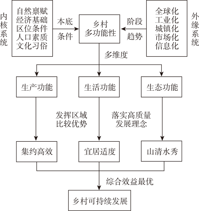
McDonoug等[34]认为区域发展只追求生产效益容易导致极端的资本主义,只追求生活效益容易导致极端的社会主义,只追求生态效益容易导致极端的生态主义,故乡村发展需要协调好生产、生活和生态之间的关系。党的十九届四中全会《中共中央关于坚持和完善中国特色社会主义制度 推进国家治理体系和治理能力现代化若干重大问题的决定》也明确指出:“中国坚定走生产发展、生活富裕、生态良好的文明发展道路,建设美丽中国”,讲求生产、生活和生态的可持续发展。同时,国土空间规划的“三生”空间理论也指出“三生”功能的合理配置是实现区域协调发展的重要手段,促进生产空间集约高效、生活空间宜居适度、生态空间山清水秀是乡村发展的时代要求[35]。因此,本文认为乡村多功能性是乡村依据其内核系统,在外缘系统的影响下,乡村的生产功能、生活功能和生态功能及其交互作用状况,并受当前所处发展阶段决定的发展趋势的影响,具有明显的时代内涵(图1)。乡村多功能性不仅仅是理解乡村发展路径的框架,也是一种解释理想乡村发展模式的工具[11],有助于乡村建设行动的实施。
图1
1.2 乡村功能空间分化的理论逻辑
乡村生产功能、生活功能、生态功能间的交互作用是依托乡村主体多元化发展需求而形成的,实际上是稀缺的土地资源在生产、生活和生态之间数量和空间上再分配的结果,体现了区域发展的阶段性特征,对乡村发展有重要影响。乡村的生产功能、生活功能和生态功能存在着密切的交互作用,乡村多功能性更是以这三者间的交互作用为核心[11]。理论上,生产功能、生活功能和生态功能间交互作用,可以形成不同的乡村功能分化类型(图2)。当3种功能均发展较好时,乡村多功能性强,呈现综合效益最优的特点,为综合发展型,对于外部环境的变化,乡村具有较强的适应能力;当2种功能发展较好时,乡村多功能性中等,呈现综合效益中等的特点,为双功能型,对于外部环境的变化,乡村具有一定的适应能力;当只有1种功能或没有功能发展较好时,乡村多功能性较弱,呈现综合效益较低的特点,为单功能主导型或均衡发展型,乡村发展极易受到外部环境变化的冲击,乡村缺乏有效的应对策略,乡村的脆弱性强。此外,在只有1种功能发展较好的极端情况下,仅仅具备生产功能的地区往往是独立工业区、矿区、农林牧渔基地等,仅仅具备生态功能的地区会产生非生产主义倾向,仅仅具备生活功能的地区则会形成脆弱的乡村社区。
图2
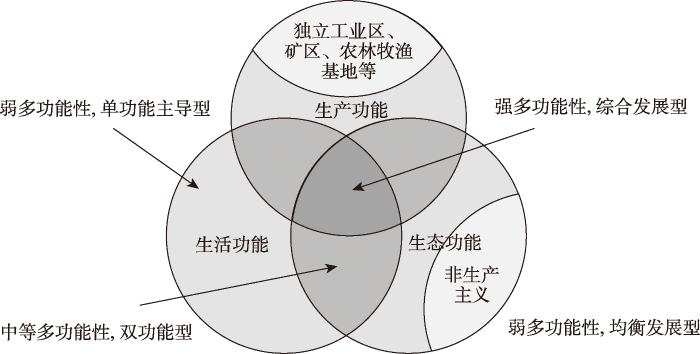
图2
“三生”功能的交互作用及乡村功能分化类型
Fig.2
Interaction of production-living-ecological functions and the types of rural function
1.3 乡村多功能指标体系构建
乡村功能反映乡村为一定地域范围内社会经济活动发挥的作用[18]。在借鉴既有研究的基础上,本文从生产功能、生活功能和生态功能3个方面构建乡村多功能评价指标体系[22⇓⇓⇓⇓-27],考虑数据资料的可获得性,选取了11项指标进行乡村多功能评价(表1)。具体如下:生产功能是指乡村经济发展的总体活力水平,是产业兴旺的重要标志,包括非农生产功能和农业生产功能,其中非农生产功能选取夜间灯光密度、公司企业数量来代表,农业生产功能选取农林牧渔基地数量和粮食产量来代表;生活功能是指乡村可以为居民提供的居住条件和社会服务的水平,是宜居便利的保证,包括居住保障功能和服务保障功能,其中居住保障功能选取人口密度和居民点用地比例来代表,服务保障功能选取路网密度和社会服务密度来代表;生态功能是指乡村地区的生态环境总体状况,包括生态观赏功能和生态保持功能,其中生态观赏功能选取景观多样性指数来代表,生态保持功能选取植被覆盖度和生物丰度指数来代表。
表1 乡村多功能评价指标体系
Tab.1
| 乡村功能 | 子功能 | 指标层(单位) | 方向 | 权重 | 指标解释与计算方法 |
|---|---|---|---|---|---|
| 生产功能 | 非农生产功能 | 夜间灯光密度(DN/km2) | + | 0.550 | 夜间灯光灰度值(SUM)/区域面积 |
| 公司企业数量(个) | + | 0.155 | 提取镇域范围的公司企业数量 | ||
| 农业生产功能 | 农林牧渔基地数量(个) | + | 0.201 | 提取镇域范围的农林牧渔基地数量 | |
| 粮食产量(t) | + | 0.095 | 根据耕地NDVI值和粮食产量计算得到 | ||
| 生活功能 | 居住保障功能 | 人口密度(人/km2) | + | 0.406 | 从栅格数据中提取获得 |
| 居民点用地比例(%) | + | 0.109 | (城镇用地+农村居民点)/区域面积 | ||
| 服务保障功能 | 路网密度(km/km2) | + | 0.319 | 乡道及以上道路长度/区域面积 | |
| 社会服务密度(个/km2) | + | 0.165 | 社会服务数量/区域面积 | ||
| 生态功能 | 生态观赏功能 | 景观多样性指数 | + | 0.531 | 景观类型的丰富度和复杂度 |
| 生态保持功能 | 植被覆盖度 | + | 0.157 | NDVI均值 | |
| 生物丰度指数 | + | 0.312 | 生态系统活力[36] |
注:由于各项指标的单位不同,为消除量纲的影响,运用极差标准化法对指标数据进行标准化处理;权重采用的是熵值法和AHP计算得出的综合权重;夜间灯光数据可以准确地反映当地非农经济发展水平,故采用2020年的VIIRS夜间灯光数据作为表征乡村非农生产功能的指标[
1.4 功能指数测度模型
在指标数据标准化及综合权重计算的基础上(表1),将各指标的权重与其标准化值相乘求和,分别计算各镇域单元的生产功能、生活功能和生态功能得分,具体计算公式如下:
式中:Si为第i个镇域单元的乡村功能得分,数值越大代表该项功能越强;
然后,采用全局Moran's I测度山东省1636个镇域单元生产功能、生活功能和生态功能的空间相关性,进而确定其在省域层面上的总体空间特征[17]。
1.5 功能间相互作用测度模型
Spearman相关分析是英国心理学家Charles Edward Spearman提出的一种非参数检验方法,用来度量定序变量间的线性相关关系,已广泛应用于测度功能间相互作用关系的研究中[17,38]。虽然Spearman秩相关系数可以说明功能间相互作用关系的总体状态,但无法揭示功能间相互作用关系的空间异质性,这就需要引入地理加权回归(geographically weighted regression, GWR)来揭示这种空间异质性。GWR模型通过将地理位置信息纳入回归方程,根据因变量和自变量地理位置的不同来探索空间关系的非平稳性,是一种局部的空间回归模型[39],可以用来揭示功能间相互作用关系的空间异质性。
1.6 数据来源
乡村是城市以外的一切地域,严格地讲是城市建成区以外的地区[40]。山东省行政区划数据来源于天地图(
2 结果与分析
2.1 乡村多功能空间格局
从乡村多功能的全局Moran's I来看,均通过显著性检验,空间自相关强度生态功能(0.715)>生活功能(0.636)>生产功能(0.485),表明生产功能、生活功能和生态功能在空间上均存在显著的集聚分布特征。利用ArcGIS 10.2将乡村的生产功能、生活功能和生态功能进行空间可视化,运用自然断裂法(jenks natural breaks)从低到高将各功能依次划分为低、较低、中、较高、高5类,结果表明,山东省乡村多功能存在显著的空间分异(图3)。
图3
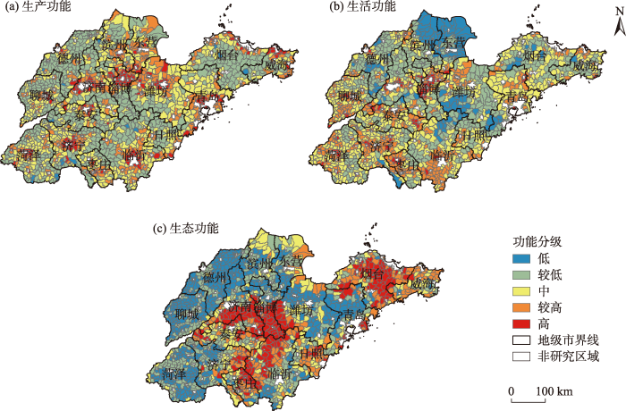
由图3a可知,生产功能较低值区的范围最广,这是因为作为农业大省大部分镇域单元有一定的农业生产能力。总体来看,生产功能的集中分布特征显著依托城市核心区域的辐射带动效应,呈现出围绕城市核心区的圈层结构,如从临沂城市核心区到外围地区呈现高值区—较高值区—中值区—较低值区的圈层结构。由图3b可知,生活功能中值区及以上主要分布在内陆平原地区,这是因为该类地区地形平坦,具备较好的农业生产条件,农业开发历史久远,人口密度较高,社会服务也相对完善,交通设施修建难度小,路网密度大。由图3c可知,生态功能中值区及以上主要分布在鲁中南山地丘陵、鲁东丘陵以及北部沿海地区,这是因为山区丘陵地带是山东重要的水源地和生态安全屏障,植被覆盖较好,生物多样性丰富,而北部沿海地区拥有大面积的近海和滨海湿地。
2.2 乡村功能间相互作用
2.2.1 乡村功能间的总体关系
从表2乡村功能间的相关性分析中可知,生产功能与生活功能显著正相关,通常生产功能的发展为生活功能的发挥提供了就业机会、工资收入等支撑,而生活功能的发挥又通过宜居的生活条件促进了生产功能的发展,两者总体呈现协同效应;生产功能与生态功能、生活功能与生态功能相关性均不显著,说明生产功能与生态功能、生活功能与生态功能的关系均是随机的,总体呈现兼容效应。
表2 乡村功能间的相关性分析
Tab.2
| 功能类型 | 相关系数 | ||
|---|---|---|---|
| 生产功能 | 生活功能 | 生态功能 | |
| 生产功能 | 1.000 | 0.584** (<0.001) | -0.038 (0.126) |
| 生活功能 | 0.584** (<0.001) | 1.000 | -0.018 (0.458) |
| 生态功能 | -0.038 (0.126) | -0.018 (0.458) | 1.000 |
注:**表示通过0.01的显著性水平检验;括号中数据为Sig.(双侧)。
2.2.2 乡村功能间的局部关系
由于山东省乡村地理环境的差异性和社会需求的多样性,乡村功能间相互作用关系存在空间异质性,故通过引入GWR模型进行局部空间回归分析探究功能间相互作用的方向和强度在不同镇域单元的空间差异。结合地理空间数据的非线性、非正态等特点[38],本文分别以生产功能、生活功能和生态功能的秩(根据值越大,秩越大的原则,确定各功能和参考变量的秩)作为因变量,以其余2个功能及参考变量的秩为自变量进行GWR回归分析。对GWR模型的残差验证发现,3个模型的残差均不存在显著的空间自相关性,表明残差随机分布,模型的关键解释变量均未缺失,故使用GWR方法是合理的。生产、生活、生态功能的GWR模型校正R2依次为0.932、0.977、0.668,条件数均小于30,表明模型均通过了多重共线性诊断,模型的拟合优度均较高,反映出空间回归结果可信,可知功能间相互作用关系具有空间非平稳性,存在明显的空间差异,但差异程度及所呈特征有所不同(图4)。
图4
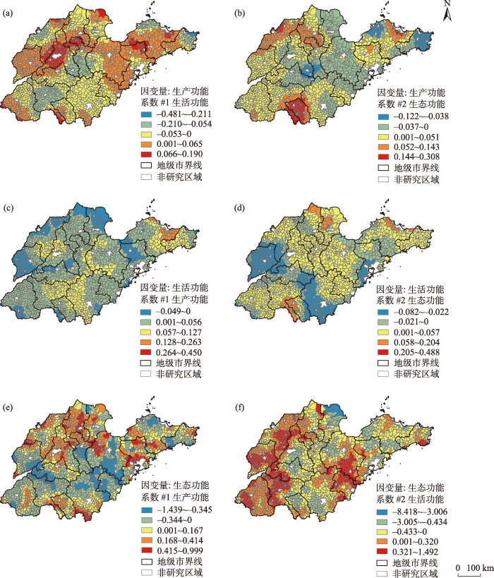
图4
乡村功能间相互作用关系的空间差异
Fig.4
Spatial differences of the interactive relationship of rural functions
由图4可知,生活功能、生产功能、生态功能间的相互作用既存在正向影响,也存在负向影响,协同效应与冲突效应并存。由图4a、4c可知,生活功能对生产功能正向影响的地域主要分布在山东中北部、胶东半岛和部分平原地区,生活功能对生产功能负向影响的地域主要分布在山东中南部地区,而生产功能对生活功能以正向影响为主,影响较大的地域主要分布在山东中西部和东部的烟台威海地区。由图4b、4e可知,生态功能与生产功能呈现正向关系的地域主要分布在山东北部平原、胶东半岛和山东南部部分地区,呈现负向关系的地域则主要分布在山东中部地区。由图4d、4f可知,生态功能与生活功能相互作用存在较大的空间差异。其中,生态功能对生活功能正向影响的地域主要分布在山东中部及北部、西南部和烟台威海地区,负向影响的地域主要分布在山东西部和胶东半岛中部;生活功能对生态功能正向影响的地域主要分布在山东西北部和山东半岛中部,负向影响的地域主要分布在山东中部、黄河三角洲和胶东半岛。
2.3 乡村功能空间分化类型
根据乡村功能空间分化的理论逻辑进行类型划分,参考徐凯等[17]的优势功能划分方法确定类型划分的临界值。首先计算各功能的均值和标准差,若一个镇域单元的某项功能大于“该项功能均值+0.5倍标准差”(临界值),则这个镇域单元的该项功能为优势功能(即具备比较优势);反之,则不是优势功能。若某个镇域单元没有优势功能,所具备的优势效益不足,则视其为均衡发展型;若某个镇域单元只有1种优势功能,所具备的优势效益也较为单一,则视其为单功能主导型,如生产功能主导型、生活功能主导型等;若某个镇域单元有2种优势功能,所具备的优势效益较为多样,则视其为双功能型,如生产—生活型、生产—生态型等;若某个镇域单元有3种优势功能,所具备的优势效益最为多样,则视其为综合发展型。根据上述乡村功能类型划分方法,山东省1636个镇域单元共划分出8种类型(图5),且各类型乡村功能间的相互作用关系存在一定差异(表3、图4)。
图5
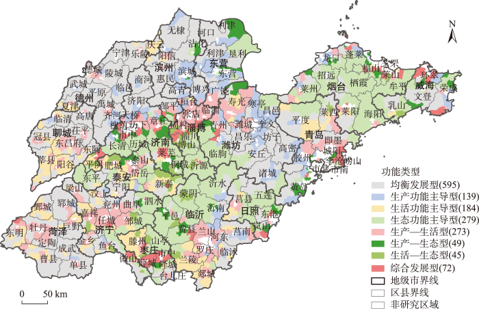
图5
乡村功能空间分化类型
注:图例括号中数据为各类型镇域单元个数。
Fig.5
Differentiation of functional types by town in Shandong Province
表3 不同类型乡村功能间相互作用的系数正负值数量
Tab.3
| 类型 | 生产功能 | 生活功能 | 生态功能 | |||||
|---|---|---|---|---|---|---|---|---|
| 生活功能 | 生态功能 | 生产功能 | 生态功能 | 生产功能 | 生活功能 | |||
| 均衡发展型 | +296, -299 | +444, -151 | +484, -111 | +333, -262 | +344, -251 | +442, -153 | ||
| 生产功能主导型 | +76, -63 | +66, -73 | +124, -15 | +90, -49 | +91, -48 | +54, -85 | ||
| 生活功能主导型 | +95, -89 | +154, -30 | +123, -61 | +72, -112 | +111, -73 | +87, -97 | ||
| 生态功能主导型 | +115, -164 | +150, -129 | +263, -16 | +170, -109 | +104, -175 | +82, -197 | ||
| 生产—生活型 | +134, -139 | +219, -54 | +241, -32 | +170, -103 | +134, -139 | +127, -146 | ||
| 生产—生态型 | +24, -25 | +19, -30 | +43, -6 | +25, -24 | +29, -20 | +12, -37 | ||
| 生活—生态型 | +11, -34 | +27, -18 | +40, -5 | +28, -17 | +22, -23 | +14, -31 | ||
| 综合发展型 | +32, -40 | +43, -29 | +67, -5 | +53, -19 | +42, -30 | +23, -49 | ||
注:“+”表示正值,“-”表示负值,数值表示该种类型系数的数量。
均衡发展型(595个镇域单元):数量最多,分布范围广,围绕山东中部山区近似半环形。该类地区地势低平,耕地集中连片,质量较高,农业生产条件较好,大部分地区具有相对较长的农业开发历史,是山东省的农业主产区。该类型镇域单元未来的发展策略:① 要大力发展畜牧业,走农牧结合之路,夯实产业基础,加强财政转移支付力度,适当增加种粮补贴,扭转粮食增产不增收的困境,实现农民增收的同时确保国家粮食安全;② 加强乡村人口的劳动技能培训,提高乡村居民的思想认识水平,增强其对农业新技术、新方法的吸收能力,积极培育农业特色产业,夯实乡村发展的内生动力;③ 地方政府应制定相应措施,引导农户外出务工,拓宽非农就业渠道,促进农户生计多样化,减少农户对粮食作物种植的过度依赖,提高农户生计能力。
生产功能主导型(139个镇域单元):分布呈现大分散、小集中的特点。该类地区地形较为平坦,紧邻城市核心区或城关镇,具备良好的区位条件,又有重要交通线通过(如高速公路、国道、城市主干道等),有利于承接产业转移,是城市核心区生产功能扩散的重要区域。该类型镇域单元未来的发展策略:① 依托城市发展需求,利用较好的区位条件和交通条件,适度承接城市的产业转移,为城市的产业发展提供配套服务;② 适度拓展生态空间比例,提高乡村生态宜居条件,严守耕地保护红线,降低生产与生态间的冲突效应,减少乡村人口外流;③ 作为重点镇域,适度活化土地产权制度,吸引外来人口聚居,提高社会服务水平,发挥生产和生活的协同效应;④ 规范产业园区建设,实现工业区和居民区的分离,提高企业的运行效率,建设宜居的乡村生活环境。
生活功能主导型(184个镇域单元):主要分布在山东西南部,少数零散分布。该类地区地形较为平坦,耕地集中连片,农业生产条件较好,具有一定的经济效益,为人口的早期聚居和社会服务的供给提供了较为稳定的产业基础,但在当前工业化、城镇化的背景下,容易形成脆弱的乡村社区。该类型镇域单元未来的发展策略:① 积极承接中心城市或城关镇的产业扩散,发展商贸、物流等第三产业,提升生产功能,发挥功能间协同效应;② 发展经济附加值高的现代设施农业,满足中心城市或城关镇居民对新鲜蔬菜、水果等农产品的多样化需求,提供一定的就业机会,带动农民增收;③ 与相邻的镇域单元构建优势功能间的协作机制,引导乡村居民通勤就业,减少乡村居民通勤就业的时间成本,实现就业机会与就业需求的匹配,并积极发展劳务输出。
生态功能主导型(279个镇域单元):数量较多,主要分布在鲁中南山地丘陵和胶东丘陵。该类地区更加倾向于非生产主义,除个别位于城市核心区附近外,大部分区位条件较差,交通不便,保护区面积比重高,耕地不足。该类型镇域单元未来的发展策略:① 加强财政转移支付,点上开发、面上保护,坚守林地保护红线,发展绿色生态林业经济,探索应季林特产品的种养殖,将生态资源优势转变为经济价值;② 开展林特产品的深加工,加强与互联网电商平台的合作,打造特色品牌,提高产品附加值,带动农民增收;③ 养殖水域要适度降低养殖密度和饵料密度,保证水产品品质的同时避免因密度双高造成水质污染;④ 为黄河口湿地提供足够的生态保护资金,加大生态补偿力度,石油开采支付生态补偿费用,构建长效补偿机制,边缘区发展生态旅游和无污染工业。
生产—生活型(273个镇域单元):主要分布在平原地带的城市核心区和城关镇附近。该类地区具备较好的区位条件,地形也较为平坦,是城市核心区与城关镇产业转移和区域产业布局的重要地区,经济发展活力较强,交通条件较好,社会服务较为完善,是乡村生产功能和生活功能协同发展的典型区。该类型镇域单元未来的发展策略:① 紧紧把握经济发展的比较优势,提供宽松的人口落户政策,吸引乡村人口聚居,提高乡村城镇化水平,使乡村城镇化和工业化同步发展;② 加强龙头企业培育,拓展企业融资渠道,根据市场发展趋势更新技术装备,依托资源优势打造拳头产品,将资源优势深度转化为产业优势和经济效益;③ 规范产业园区建设和管理,减少企业在运营、管理、运输等过程中对居民正常生活的影响,建设宜业、宜居的乡村生产、生活环境。
生产—生态型(49个镇域单元):数量较少,主要分布在距离城市核心区或城关镇较近的山区丘陵地带。该类地区靠近城市核心区,具备较好的区位条件,交通便利,受城市核心区经济溢出效应的影响显著,又拥有较好的生态环境基础。该类型镇域单元未来的发展策略:① 充分利用距离城市核心区较近的区位优势,发展符合城市需求的无污染工业、生态旅游、生态农业等,与城市产业形成互补协同的发展态势;② 依托较为便利的交通条件,舒适、宜居的自然生态环境,适度建设低密度的多层住宅小区,促进生活和生态的融合,完善社会服务供给,提高居民幸福感,吸引外来人口定居;③ 严守生态保护红线,减少生产活动与生态环境的冲突,完善生态补偿机制,加强生态保护区域的保护力度,保障生态环境质量,夯实区域发展的环境基础。
生活—生态型(45个镇域单元):数量最少,主要分布在山区丘陵地带的城市核心区或城关镇附近。该类地区社会服务较为完善,植被覆盖较好,生态保育价值突出,乡村农林复合型经济比重高,不适合进行大面积的开发。该类型镇域单元未来的发展策略:① 引入适合山区丘陵地带作业的农业机械,提高农业劳动生产率,稳步提升农民务农收益,并规范梯田建设,避免坡地开垦,减少水土流失,削弱生产活动与生态保护的冲突;② 在加强财政转移支付,完善生态补偿机制基础上,利用生态优势开展林特产品种养殖,以增加农民收入的方式切实提高农民生态保护的积极性,并引导农业剩余劳动力外出务工,拓展非农就业机会,满足农民的生计需求;③ 严守生态红线和耕地红线,点上开发、面上保护,充分利用坡地、荒地等未利用土地增加发展空间。
综合发展型(72个镇域单元):数量较少,主要分布在城市核心区或城关镇附近的山区丘陵地带。该类地区区位条件优越,交通运输便利,城乡联系密切,生态环境优良,乡村生产、生活和生态呈现协同发展的态势。该类型镇域单元未来的发展策略:① 加强道路交通、公共服务等基础设施建设,打造配套齐全的产业园区,承接产业转移和布局,引导产业集聚,鼓励企业间的配套协作,切实提高产业竞争力;② 利用区位优势,打造农业产业基地,因地制宜发展设施农业、优质果园、畜牧养殖、休闲农业,供给中心城市或城关镇新鲜蔬菜、优质水果、禽蛋肉奶等农产品,并提供游憩空间;③ 严守生态保护红线,完善生活垃圾处理体系,促进工业废水、废气、废渣等无害化处理,减少生产、生活和生态间的冲突,深入推进“三生融合”,打造乡村振兴的齐鲁样板。
3 结论与讨论
3.1 结论
本文立足于镇域尺度,从“三生”功能的角度,综合采用POI、土地利用等多源数据,运用功能指数测度模型、全局空间自相关和功能间相互作用测度模型,以山东省为例开展乡村功能空间分化研究,主要结论如下:
(1) 山东省镇域乡村“三生”功能空间格局存在显著的集聚分布特征和空间分异。生产功能显著依托城市核心区域的辐射带动效应,呈现出围绕城市核心区的圈层结构;生活功能中值区及以上主要分布在内陆平原地区;生态功能中值区及以上主要分布在鲁中南山地丘陵、鲁东丘陵以及北部沿海地区。
(2) 在乡村功能间相互作用的方向上,总体关系和局部关系既存在一致性,也存在一定的差异性。从总体关系来看,生产功能与生活功能显著正相关,生产功能与生态功能、生活功能与生态功能相关性不显著。从局部关系来看,乡村功能间相互作用均存在显著的空间异质性,具体如下:生活功能、生产功能、生态功能间的相互作用既存在正向影响,也存在负向影响,协同效应与冲突效应并存。
(3) 根据乡村功能空间分化的理论逻辑进行类型划分,将山东省镇域乡村划分为8种功能类型:均衡发展型、生产功能主导型、生活功能主导型、生态功能主导型、生产—生活型、生产—生态型、生活—生态型和综合发展型,并揭示了不同类型乡村功能间相互作用关系的数量差异,进而提出了不同类型乡村未来发展的初步建议,以期为促进乡村的多元化发展和打造乡村振兴的齐鲁样板提供参考。
3.2 讨论
当前,推动乡村全面振兴,发掘乡村的独特价值和多元功能,仍是党和国家面临的重要任务。在此背景下,从“三生”视角解析乡村多功能性内涵,明确乡村功能的空间特征,并探索乡村功能间相互作用关系的空间异质性,进而揭示乡村功能多元化现状及未来初步的发展策略,有助于响应城乡融合发展和乡村振兴战略的实际需要。由于对镇域发展的重要性认识不足,且镇域层面系统的统计数据较为缺乏,学者们对镇域发展的研究较少[42],而立足镇域尺度从“三生”功能的角度采用兴趣点(POI)、土地利用、夜间灯光等多源数据来客观认识镇域乡村,不仅有助于丰富镇域发展研究,深化多功能乡村研究,也具有较强的实践指导价值与意义。具体来看,与县域尺度相比[17],镇域尺度的乡村功能空间分化研究具有明显的优势和特点,不仅可以准确地刻画乡村的空间范围,而且所承载的地理信息精度更高,更有助于揭示乡村多功能性在空间分布上的差异性和规律性[43],从而为山东省打造乡村振兴的齐鲁样板提供更精准的政策着力点和路径参考。但本文研究也存在不足:① 仅基于一期数据,尚不能判断乡村功能间相互作用关系的时空演变特征,未来还需结合长时间序列数据深入探讨;② 由于乡村功能具有明显的尺度效应,不同尺度乡村功能具有不同的特征,针对典型区域亟待开展村域尺度、农户尺度等多尺度的多功能乡村研究,探究不同尺度间的内在关联,是未来进一步研究的方向。
参考文献
中国新时代城乡融合与乡村振兴
[J].
DOI:10.11821/dlxb201804004
[本文引用: 1]

城市与乡村是一个有机体,只有二者可持续发展,才能相互支撑。依据人地关系地域系统学说,城乡融合系统、乡村地域系统是全新认知和理解城乡关系的理论依据。针对日益严峻的“乡村病”问题,全面实施乡村振兴,既是推进城乡融合与乡村持续发展的重大战略,也是破解“三农”问题,决胜全面建成小康社会的必然要求。本文探讨了新时代城乡融合与乡村振兴的基础理论,剖析了乡村发展面临的主要问题,提出了问题导向的中国城乡融合与乡村振兴科学途径及研究前沿领域。结果表明:① 城乡融合与乡村振兴的对象是一个乡村地域多体系统,包括城乡融合体、乡村综合体、村镇有机体、居业协同体,乡村振兴重在推进城乡融合系统优化重构,加快建设城乡基础网、乡村发展区、村镇空间场、乡村振兴极等所构成的多级目标体系。② 中国“三农”问题本质上是一个乡村地域系统可持续发展问题,当前乡村发展正面临主要农业生产要素高速非农化、农村社会主体过快老弱化、村庄建设用地日益空废化、农村水土环境严重污损化和乡村贫困片区深度贫困化等“五化”难题。③ 乡村是经济社会发展的重要基础,城乡融合与乡村振兴战略相辅相成,乡村振兴应致力于创建城乡融合体制机制,推进乡村极化发展,按照产业兴旺、生态宜居、乡风文明、治理有效、生活富裕的要求,构建乡村地域系统转型—重构—创新发展综合体系。④ 乡村振兴地理学研究应着眼于乡村地域系统的复杂性、综合性、动态性,探究以根治“乡村病”为导向的新型村镇建设方案、模式和科学途径,为实现新时代中国乡村振兴战略提供理论参考。
Research on the urban-rural integration and rural revitalization in the new era in China
DOI:10.11821/dlxb201804004
[本文引用: 1]
Cities and villages are components of a specific organism. Only the sustainable development of two parts can support the prosperous development as a whole. According to the theory of man-earth areal system, urban-rural integrated system and rural regional system are the theoretical bases for entirely recognizing and understanding urban-rural relationship. To handle the increasingly severe problems of "rural disease" in rapid urbanization, accelerating rural revitalization in an all-round way is not only a major strategic plan for promoting the urban-rural integration and rural sustainable development, but also a necessary requirement for solving the issues related to agriculture, rural areas, and rural people in the new era and securing a decisive victory in building a moderately prosperous society in all respects. This study explores the basic theories of urban-rural integration and rural revitalization and analyzes the main problems and causes of rural development in the new era, proposing problem-oriented scientific approaches and frontier research fields of urban-rural integration and rural revitalization in China. Results show that the objects of urban-rural integration and rural revitalization is a regional multi-body system, which mainly includes urban-rural integration, rural complex, village-town organism, and housing-industry symbiosis. Rural revitalization focuses on promoting the reconstruction of urban-rural integration system and constructs a multi-level goal system including urban-rural infrastructure networks, zones of rural development, fields of village-town space and poles of rural revitalization. Currently, the rural development is facing the five problems: high-speed non-agricultural transformation of agriculture production factors, over-fast aging and weakening of rural subjects, increasingly hollowing and abandoning of rural construction land, severe fouling of rural soil and water environment and deep pauperization of rural poverty-stricken areas. The countryside is an important basis for the socioeconomic development in China, and the strategies of urban-rural integration and rural revitalization are complementary. The rural revitalization focuses on establishing the institutional mechanism for integrated urban-rural development and constructs the comprehensive development system of rural regional system, which includes transformation, reconstruction and innovation in accordance with the requirements of thriving businesses, pleasant living environments, social etiquette and civility, effective governance, and prosperity. Geographical research on rural revitalization should focus on the complexity and dynamics of rural regional system and explore new schemes, models and scientific approaches for the construction of villages and towns, which are guided by radical cure of "rural disease", implement the strategy of rural revitalization polarization, construct the evaluation index system and planning system of rural revitalization, thus providing advanced theoretical references for realizing the revitalization of China's rural areas in the new era.
镇域发展研究进展与展望
[J].
Current progress and future prospect of research in town development
DOI:10.2307/142491 URL [本文引用: 1]
基于多功能理论的中国乡村发展多元化探讨: 超越“现代化”发展范式
[J].
DOI:10.11821/dlxb201502007
[本文引用: 2]
传统的乡村现代化发展范式和地理学关于乡村的区域差异研究之间存在缝隙,不足以为快速演化分异的乡村地域发展提供直接理论支撑。本文引入西方近20年来逐渐兴起的多功能农业与多功能乡村理论,从新的视角观察思考中国乡村多元化发展的目标、路径及对策。首先从经济、社会和环境三个方面反思中国乡村现代化的基本历程与得失,以及西方国家乡村现代化产生的问题,指出传统的农业农村现代化发展在很大程度是以牺牲乡村环境和乡村社会机理脆弱化为代价的,也造成了乡村经济对外部支持的过度依赖,仅仅强调“现代化”发展范式显然是不够的;然后简要介绍了国外多功能农业与多功能乡村理论;在此基础上,从功能角度提出中国农业农村发展的多元目标,推演探讨农业农村发展的区域差异化路径及对策。
Diversified agriculture and rural development in China based on multifunction theory: Beyond modernization paradigm
DOI:10.11821/dlxb201502007
[本文引用: 2]
There is a big gap between general rural modernization paradigm and huge empirical rural geography studies. This gap results in impotent development strategies on regionally differentiated countryside. Based on multifunctional agriculture theory and multifunctional rural theory which emerged in Western World as a new paradigm, this paper discusses the multiple objectives, differentiated pathways and policies of agriculture and rural development in China. Firstly, this paper reflects the problems and challenges caused by modernization paradigm in rural China on economic, social, and environmental aspects, as well as that of western developed countries. It can be concluded that conventional agricultural and rural modernization is developed largely at the expense of rural environment, social fabric and economic viabilities. Obviously, "modernization development paradigm" alone is not enough for healthy agricultural and rural development in such booming economy as China. A better paradigm should be developed which takes economic development, social justice and environmental sustainability into account at the same time. After a brief review of multifunctional agriculture theory and multifunctional rural theory overseas, the multiple objectives of agriculture and rural development in China are put forward. These multiple objectives, however, should not and could not be a burden on rural space indiscriminatingly due to the enormous differentiation of natural and socio-economic conditions. Thus, the final but main part of this paper envisions the differentiated pathways and policy portfolios of agricultural and rural development in China from the perspective of territorial division.
From productivism to post-productivism and back again? Exploring the (un) changed natural and mental landscapes of European agriculture
[J].DOI:10.1111/tran.2001.26.issue-1 URL [本文引用: 1]
Impulses towards a multifunctional transition in rural Australia: Gaps in the research agenda
[J].DOI:10.1016/j.jrurstud.2005.08.006 URL [本文引用: 2]
基于乡村多功能理论的贫困村域演变特征与振兴路径探讨: 以海南省什寒村为例
[J].
DOI:10.18306/dlkxjz.2019.09.016
[本文引用: 1]
对于多数农村地区而言,贫困是制约乡村发展的重要因素,为摆脱对农业的过度依赖和单一生产功能,乡村多功能逐步进入人们的视野并日渐受到关注,在很大程度上多功能路径有助于减少贫困发生率,并提高农村社区和家庭面对生存压力的能力。论文立足于乡村振兴的时代背景,在阐释乡村多功能概念内涵的基础上,采用实地调研和半结构式访谈等方法,基于多功能视角剖析贫困村域乡村发展的演变特征及驱动因素,总结提炼其创新发展模式,在此基础上进一步探讨贫困村域乡村振兴的路径选择。结果表明:① 在内外部驱动力的作用下,海南省什寒村实现了从弱势的贫困农村向产品多样化的多功能乡村转变;② 乡村农业生产、就业与社会保障、生态保育及文化传承等多项功能的协调发展,对于提高农村社会经济发展水平、增强乡村弹性具有积极意义;③ 驱动乡村多功能演化的因素包含政策支持、市场需求、自然本底、资金技术、行为主体和文化特质等多个方面;④ 针对贫困村域乡村发展存在的制约因素,提出从宏观层面提供乡村振兴外援力、从中观层面促进乡村振兴交互力、从微观层面激发乡村振兴内生力,通过总体谋划、各个击破以实现乡村振兴。最后从多功能视角,对乡村振兴发展的困境与出路进行了探讨。
Characteristics of change and vitalization pathways of poor villages based on multifunctional rural development theory: A case study of Zahan Village in Hainan Province
DOI:10.18306/dlkxjz.2019.09.016
[本文引用: 1]
For most regions in rural China, poverty is an important factor restricting rural development. In order to reduce excessive dependence on agriculture and single production function, rural multifunctionality is receiving increasing more attention. Multifunctional rural development is to a great extent conducive to reducing the incidence of poverty and improving the ability of rural communities and families to face the pressure of survival. Under the background of rural revitalization in China, this study used field investigation and semistructured interview results to analyze the characteristics of change and driving factors of rural development in poor villages from the perspective of multifunctionality. Based on the development model of Zahan Village, we further explored alternative pathways for vitalizing poor rural villages. The results show that: 1) Under the influence of "policy opportunity geography", Zahan Village has experienced a transition from a vulnerable poor rural village to a village with diversified functions. 2) The coordinated development of agricultural production, social security, ecological conservation, and cultural heritage protection in rural areas has positive implications for improving the level of rural socioeconomic development and enhancing rural resilience. 3) Factors driving rural multifunctional transition include policy support, market demand, natural environment, capital and technology, stakeholders, and cultural traits. 4) In view of the constraints of rural development in poor villages, it is proposed to provide external support for rural vitalization from the macro level, promote synergistic interaction from the meso level, stimulate endogenous forces from the micro level, and achieve rural vitalization through overall planning and various breakthroughs. Finally, based on the multifunctional rural development theory, the dilemmas and prospect of rural vitalization and development were discussed.
Rural futures: The consumption countryside and its regulation
[J].DOI:10.1111/soru.1999.39.issue-4 URL [本文引用: 1]
Multifunctional agriculture: A transition theory perspective
[J].DOI:10.1016/j.jrurstud.2009.10.001 URL [本文引用: 1]
基于村域多功能视角的乡村振兴策略: 以鄂西郧阳山区为例
[J].
DOI:10.18402/resci.2019.09.11
[本文引用: 1]
乡村振兴战略是新时代背景下中国妥善解决三农问题的重大战略决策。村域多功能发展及管理是实现乡村全面振兴的有效契合点和新路径。本文通过系统建立评价指标体系,应用综合评价法对研究区村域各项功能及多功能指数展开评价,利用纵横对比法识别村域主导功能及短板功能,确定各村域的发展类型,并提出了差异化发展路径。研究结果表明:①村域农业生产功能、居住生活功能、社会保障功能及生态保育功能的空间分异明显;②山区村域多功能指数整体不高,且各村域差异不大;③通过识别各村域主导功能及短板功能,建立发展类型划分规则,将研究区划分为极化发展型、主导发展型及综合发展型3大发展类型,并进一步将极化发展型细分为4类发展亚型,将主导发展类型分为3类发展亚型,最终对各类发展类型提出了相应的发展策略。本文从村域多功能视角探索乡村振兴策略,为中国新时代乡村振兴战略提供借鉴,也有利于拓展地域多功能研究视角,进一步丰富多功能研究理论框架。
Rural revitalization strategy based on the perspective of rural multifunctions: A case of the mountainous areas in Yunyang District of Shiyan City, western Hubei Province
DOI:10.18402/resci.2019.09.11
[本文引用: 1]
Under the background of China’s rapid urbanization, rural areas are still facing a severe situation of lagging behind or even backward development. Rural revitalization strategy is a significant strategic decision for China to properly solve the “Three Rural Issues.” The multifunctional development and its management of villages will be a focal point and a new path to realize the overall revitalization of the countryside. This study established a systematic evaluation index to evaluate the multifunctions of village space, and used the horizontal and vertical comparison methods to identify dominant functions and weak functions of each village, determine the development type of the village, and finally put forward different development strategies for the villages. The results are as follows: (1) The agricultural production function, living function, social security function, and ecological conservation function are spatially different in the mountainous rural areas; (2) The multifunction index values are low overall and show little variations for the villages; (3) Through identifying the dominant functions and weak functions, the study established a set of criteria to classify development types for villages, and then divided the villages of the study area into polarized development type, leading development type, and comprehensive development type. Next, the polarized development villages were divided into four subtypes of development, and the leading development villages were divided into three subtypes. Finally, we put forward the corresponding development strategies for various types of villages. This study explored the strategies of rural revitalization from the perspective of village space multifunctions, which may provide some practical reference for rural revitalization strategy in the new era, expand the perspective of regional multifunctional research, and enrich the theoretical framework of multifunctional study.
Multifunctional 'quality' and rural community resilience
[J].DOI:10.1111/tran.2010.35.issue-3 URL [本文引用: 4]
Rural development and the regional state: Denying multifunctional agriculture in the UK
[J].DOI:10.1016/j.jrurstud.2008.04.001 URL [本文引用: 1]
Comparative review of multifunctionality and ecosystem services in sustainable agriculture
[J].
DOI:10.1016/j.jenvman.2014.10.020
PMID:25463579
[本文引用: 1]
Two scientific communities with broad interest in sustainable agriculture independently focus on multifunctional agriculture or ecosystem services. These communities have limited interaction and exchange, and each group faces research challenges according to independently operating paradigms. This paper presents a comparative review of published research in multifunctional agriculture and ecosystem services. The motivation for this work is to improve communication, integrate experimental approaches, and propose areas of consensus and dialog for the two communities. This extensive analysis of publication trends, ideologies, and approaches enables formulation of four main conclusions. First, the two communities are closely related through their use of the term "function." However, multifunctional agriculture considers functions as agricultural activity outputs and prefers farm-centred approaches, whereas ecosystem services considers ecosystem functions in the provision of services and prefers service-centred approaches. Second, research approaches to common questions in these two communities share some similarities, and there would be great value in integrating these approaches. Third, the two communities have potential for dialog regarding the bundle of ecosystem services and the spectrum of multifunctional agriculture, or regarding land sharing and land sparing. Fourth, we propose an integrated conceptual framework that distinguishes six groups of ecosystem services and disservices in the agricultural landscape, and combines the concepts of multifunctional agriculture and ecosystem services. This integrated framework improves applications of multifunctional agriculture and ecosystem services for operational use. Future research should examine if the framework can be readily adapted for modelling specific problems in agricultural management. Copyright © 2014 Elsevier Ltd. All rights reserved.
Methodological and conceptual issues in the study of multifunctionality and rural development
[J].DOI:10.1111/soru.2000.40.issue-4 URL [本文引用: 1]
From subsistence farming towards a multifunctional agriculture: Sustainability in the Chinese rural reality
[J].The rural economic situation in China-with a living standard mostly at subsistence level-lags far behind the prosperous development in the cities and coastal areas. To balance this disequilibrium, comprehensive concepts and endeavors are necessary keeping in view all-not just economic-interests and needs that contribute to lively rural identities. In this context the role of agriculture, where still 50% of the Chinese population are working, will be newly defined, and sustainability concepts can help to find a readjusted position within the Chinese economy focusing on environmental health and food safety as main targets of political and other supporting measures. Within the SUCCESS project, a Concept of Sustainable Agriculture was developed and it drafts one conceivable relation between the exposure to natural resources and economy and tries to find new answers to the broad range of rural challenges in China. It is a qualitative model and, therefore, not always fully applicable, but in the concrete situation of villages, it shows possible directions of sustainability-oriented development by considering the typical local potentials. In the Chinese context that means identifying the different functions of agriculture-the well-known and the hidden-to make them explicit for the Chinese public and therewith to give them new significance. The article is based on a 3-years study within the EU-China Project SUCCESS with field research in four Chinese rural communities. It analyzes the agricultural sustainability potential of these selected villages against the background of massive structural changes within the next 20 years in rural China. Starting from the current agricultural reality, based on a qualitative analysis of the actual situation, local potentials and needs towards sustainable production and marketing are identified, and possible functions of the Chinese agriculture are formulated for the future.
Multifunctional adaption of farmers as response to urban growth in the Jabodetabek Metropolitan Area, Indonesia
[J].DOI:10.1016/j.jrurstud.2017.08.001 URL [本文引用: 1]
乡村地域多功能空间分异特征及类型识别: 以辽宁省78个区县为例
[J].
DOI:10.11821/dlyj020170647
[本文引用: 8]
以具有国家粮食基地和老工业基地的经济功能与特征的辽宁省为例,通过构建乡村地域多功能评价指标体系,采用ArcGIS自然间断点分级法和全局空间自相关分析农业生产、非农生产、居住生活和生态保障四类功能的空间格局特征,采用Spearman等级相关系数定量分析功能间交互作用,识别各区县优势功能类型,并提出未来发展的政策建议。结果表明:① 从省域层面看,乡村地域功能空间格局的空间差异性和空间集聚特征显著;② 根据乡村地域功能间的相关关系和功能间的互动实际,得出各功能间的交互作用类型,从而为功能调控提供指导;③ 基于功能状态和功能间的交互作用,将辽宁省78个区县划分为8种乡村地域功能类型,并根据类型提出科学谋划辽宁乡村未来发展的初步建议,为促进乡村转型与城乡统筹提供参考。
Spatial differentiation and type identification of rural territorial multi-functions in Liaoning Province
DOI:10.11821/dlyj020170647
[本文引用: 8]
In the new era, China is promoting integrated urban and rural areas. Rural territory is in the process of transformation, development and reconstruction. The features of rural territorial function diversification and multi-functionality have become more and more obvious. This paper takes Liaoning province, which is one of the national grain producing bases and old industrial bases in China, as the research area. It constructs an evaluation index system of rural territorial multifunctions from the following four aspects: agricultural production function, non-agricultural production function, dwelling and living function, and ecological service function. Jenks and Global Spatial Autocorrelation are used to explore the spatial pattern and spatial correlation of rural territorial functions. The Spearman's rho is used to analyze the interactions among rural territorial functions. This paper identifies the dominant function types of different counties in Liaoning province, and puts forward policy recommendations for their future development. The results of the study are reflected in the following three aspects: (1) The spatial distribution of rural territorial functions has obvious spatial heterogeneity and spatial agglomeration characteristics in Liaoning province. The highest and higher values of agricultural production function concentrate in the Liaohe River Plain. Non-agricultural production function decreases from the core urban areas, the highest, and higher values areas to the outside. The highest, higher, and middle values of dwelling and living function concentrate in municipal districts. The highest and higher values of ecological service function are observed in the mountainous areas. (2) According to the correlation among rural territorial functions and the actual interaction among functions, the types of interaction among functions have been clearly identified, which can provide guidance for the regulation of functions. (3) Based on the status and interactions of different functions, eight types of rural territorial functions have been identified. According to the types, preliminary proposals are put forward for the future development of rural areas in Liaoning province, which would provide references for the promotion of the rural transformation and the balanced urban and rural development.
基于功能视角的广州都市边缘区乡村发展类型分化及其动力机制
[J].
DOI:10.13249/j.cnki.sgs.2021.02.006
[本文引用: 3]
基于村庄规划详细调查数据库,采用空间集中度和功能识别等方法,深度剖析广州都市边缘区村域尺度乡村发展的类型分化及其动力机制。结果表明:① 广州都市边缘区村域乡村功能的空间梯度差异特征明显。乡村经济发展功能和社会保障功能呈现出由城区向城郊逐渐减弱的分异特征,农业生产功能和生态保育功能则由城区向城郊逐渐增强态势。以乡村主导功能为划分原则,将广州市都市边缘区乡村划分为经济发展功能主导型、社会保障功能主导型、农业生产功能主导型、生态保育功能主导型、均衡发展型和综合发展型等6种类型。② 在城乡区位上,城镇发展型、混合发展型和传统发展型3类乡村依次呈现出围绕主城区和城市副中心的圈层结构特征。③ 政府力通过行政区划调整、战略发展规划、重大项目及重大基础设施的建设推动城乡发展空间转型,奠定了乡村发展的圈层分化格局;市场力通过企业投资和产业转移助推乡村产业非农化和地域功能多样化;社会力通过经济组织发展和乡镇企业兴办等推动乡村“三生”空间重构。④ 建立多方参与的社区化管理体系、乡村群空间组织结构以及镇乡互动圈将是乡村发展优化的重点。
Differentiation and dynamic mechanism of rural development in metropolitan fringe based on the functional perspective in Guangzhou City
DOI:10.13249/j.cnki.sgs.2021.02.006
[本文引用: 3]
This article takes the differentiation of rural development types in metropolitan fringes areas as the theme. The comprehensive analysis of the rural development types, formation mechanism and optimization were examined on village scale in Guangzhou by using the village planning survey database of Guangzhou in 2013 and methods such as spatial concentration and functional identification. The results as fellows: First, the spatial gradient difference of rural function in Guangzhou is significant. The functions of economic development and social security are gradually decreasing from urban areas to suburbs, while the functions of agricultural production and ecological conservation are gradually increasing from urban areas to suburbs. According to the principle of rural dominate function, the rural areas in Guangzhou are divided into 6 types: economic development leading type, social security leading type, agricultural production leading type, ecological conservation leading type, balanced development type and comprehensive development type, among which the balanced development type is the main type. Secondly, the rural areas of Guangzhou are divided into urban development type, mixed development type and traditional development type by the characteristics of rural development and the location, which exhibit layer structures surrounding the downtown and the sub-center of city. Third, government, market and social forces are important driving forces of rural development, which exert multi-directional influences on the differentiation of rural development through different forms of action. The government promotes the rapid development of urbanization through administrative division adjustment, strategic development planning, major projects and major infrastructure construction. Market forces promote rural industrial structure transformation and non-agriculture diversified development through enterprise investment and industrial. Social forces promote the reconstruction of rural production, living and ecological space through the development of economic organizations and the establishment of township enterprises. Fourth, the system of multi-participation in the community management, the space integration of village cluster, as well as the construction of town-township interaction circle will be an important way to optimize rural development.
中国乡村发展进程与乡村振兴路径
[J].
DOI:10.11821/dlxb202106007
[本文引用: 1]
乡村发展是乡村地域系统循环累积与动态演化的结果,全面梳理乡村发展历史脉络与地域分异格局,对于科学推动新时代乡村振兴战略落实具有重要意义。基于人地关系地域系统理论和人地系统科学认知,本文解析了1978—2050年中国乡村发展演化进程,探讨了乡村转型发展与乡村振兴的内在逻辑,揭示了中国县域乡村振兴水平的空间格局,进而提出了新时代乡村振兴的关键问题及其路径对策。研究表明:① 中国1978—2050年的乡村发展可划分为解决温饱、小康建设和实现富裕三个主要阶段,是一个由低水平、基础型向高质量、创新型不断发展的过程;② 乡村振兴本质上是乡村转型发展的一个特殊阶段,是乡村发展演化到一定阶段后,为解决其面临的突出问题以向更高层次迈进的战略选择;③ 2017年中国57.3%的县域乡村振兴综合水平介于0.40~0.50之间,在空间上呈现出明显的东中西地域分异,并具有显著的聚集特征和正相关性;④ 新时代乡村振兴战略的落实重在科学识别乡村振兴的瞄准区域,综合研判乡村发展演化的趋势,系统诊断乡村地域类型的主导制约因素,全面认知城乡耦合互动的逻辑关系,进而采取针对性措施推进农业农村现代化。
The process of rural development and paths for rural revitalization in China
DOI:10.11821/dlxb202106007
[本文引用: 1]
China is a large agricultural country, and issues concerning agriculture, rural areas and farmers are closely related to national economic and social development. To achieve the "Two Centenary Goals", rural revitalization strategy has become the choice to resolve unbalanced urban-rural development and inadequate rural development in China. Rural development is a comprehensive process of cycle accumulation and dynamic evolution of rural regional system. Thus, it is of great significance to systematically analyze the process and regional pattern of rural development to scientifically promote the implementation of rural revitalization strategy in the new era. Based on the theory of human-earth areal system and human-earth system science, this study examines the process and features of rural development in China from 1978 to 2050, discusses the internal relationship between rural transformation and rural revitalization, reveals the spatial pattern of the level of county rural revitalization in 2017, and finally puts forward the key problems and countermeasures for rural revitalization in the new era. Results show that the evolution of China's rural development in the period of 1978-2050 can be divided into three stages, i.e. solving the problem of food and clothing (1978-2005), building a well-off society (2005-2020) and realizing prosperity (2020-2050). In general, it is a dynamic and continuous process from low-level and basic-type to high-quality and innovation-type. Rural revitalization is a special stage of rural transformation, and a strategic choice to solve the prominent problem in rural development when it has evolved to a certain stage, thus boosting rural development to a higher stage. In 2017, when rural revitalization strategy was initiated, the level of rural revitalization in 57.3% of the counties in China was between 0.40 and 0.50, and there was an obvious gradient differentiation from the east to the west, with significant clustering characteristics and positive correlation. Specifically, the counties featured by "high-high (H-H)" clustering were mainly distributed in the third step of the terrain and the middle of Sichuan Basin; while the counties featured by "low-low (L-L)" clustering were concentrated in western China except Sichuan Basin, the eastern part of Inner Mongolia and the north of Tianshan Mountains. Due to the regionalism, stage and the difference in constraints of rural development, the focuses of rural revitalization in the new era lie in scientifically identifying the targeting areas of rural revitalization, comprehensively judging the trends of rural development, and systematically diagnosing the dominant constraints of different types of rural areas, so as to take targeted measures to make up for the shortcomings of the modernization of agriculture and rural areas. Besides, it is necessary to fully understand the interactions between urban and rural areas, thus promoting urban-rural integrated development.
乡村地域多功能的内涵及其政策启示
[J].
Connotations of rural regional multifunction and its policy implications in China
基于乡村多功能评价的城市边缘区“三生”空间划分研究
[J].
DOI:10.18306/dlkxjz.2019.09.011
[本文引用: 1]
城市边缘区乡村多元价值凸显,迫切需以乡村多功能理论为指导划分“三生”空间,以空间重构促进转型发展。论文首先从生产、生活与生态功能方面评价城市边缘区多功能时空变化;其次进行图斑尺度“三生”空间适宜性评价,两者共同得到基于乡村多功能的“三生”空间适宜性;最后据此设计算法划分“三生”空间。研究发现:① 城市边缘区乡村休闲娱乐、观光农业等功能显现,需要重构多功能空间促进转型发展;② 江苏徐州市铜山区乡村非农生产与生活功能主要分布在与中心城区较近地区,农业空间主要分布在中心城区远郊外围,生态功能则表现出高度空间异质性,农业、非农生产与生活功能在提升,而生态功能则普遍下降;③ 县域“三生”空间划定需多尺度联合,既要考虑乡镇尺度多功能差异,还要体现图斑尺度适宜性,才能为空间规划提供有意义的借鉴。论文提出的基于乡村多功能评价的“三生”空间划分可为即将开展的国土空间规划提供科学依据。
Delineation of "production-living-ecological" space for urban fringe based on rural multifunction evaluation
DOI:10.18306/dlkxjz.2019.09.011
[本文引用: 1]
Rural multifunctional values?in urban fringes are prominent at the current stage of urbanization in China. Therefore, it is urgent to delineate "production-living-ecological" space using the rural multifunction theory in order to carry out spatial reconstruction. This study developed a comprehensive method for delineating the "production-living-ecological" space in urban fringe based on rural multifunction evaluation, taking Tongshan District of Xuzhou City for empirical research. First, the spatial and temporal changes of rural multifunctions were evaluated from the aspects of production, living, and ecological functions. Second, suitability evaluation for "production-living-ecological" space was carried out at the grid scale, and then, the rural multifunctional "production-living-ecological" space suitability evaluation result was attained. Finally, the "production-living-ecological" space was delineated. The study revealed that: 1) With the overwhelming development of rural recreation and sightseeing agriculture in urban fringe, the application of rural multifunction theory to the reconstruction of multifunctional space can promote development transition. 2) Non-agricultural production function and living function are mainly distributed in the suburbs surrounding the main urban area, while agricultural production function is mainly distributed in the outer suburbs, and ecological function shows clear spatial heterogeneity. Agricultural, non-agricultural production, and living functions are improving, while ecological function is declining. 3) "Production-living-ecological" space delineation at county level needs multiscale combination, not only considering the multifunctional differences at the township scale, but also accounting for suitability at the vector or grid level. The proposed method of delineating "production-living-ecological" space based on rural multifunctional evaluation can provide a scientific basis for spatial planning.
吉林省乡村地域多功能时空变化与耦合协调测度研究
[J].
Spatial-temporal change and coupling coordination measurement of rural territorial multi-functions in Jilin Province
辽宁省乡村多功能评价和演变特征分析
[J].
Rural multi-function evaluation and evolution characteristics in Liaoning Province
中国县域乡村地域多功能格局及影响因素识别
[J].
DOI:10.18306/dlkxjz.2019.09.005
[本文引用: 2]
论文以中国大陆县域为研究单元,构建乡村地域多功能评价指标体系,利用熵权法、半变异函数和地理探测器等模型,对2000—2015年中国乡村多功能指数进行综合测评,揭示中国县域乡村地域多功能的空间分异特征,定量识别乡村地域多功能空间分异的影响因素。研究结果表明:① 中国乡村地域多功能在空间上呈现出平原、东部沿海等地区高值集聚,高原、山地等地区低值集聚,各县域乡村地域多功能整体呈现出逐渐提升态势;② 经济发展功能和社会保障功能对乡村地域多功能的贡献率逐渐增大,农业生产功能和生态保育功能对乡村地域多功能的贡献率逐渐减小;③ 2000—2015年,中国大陆范围内县域乡村地域多功能空间自相关范围和强度总体呈现减小的趋势,随机性因子成为乡村地域多功能空间分异的主要驱动力;④ 县域经济整体发展水平和财政收入是影响乡村地域多功能空间分异的主导因素;各影响因素之间的两两交互作用会增强乡村地域多功能的空间分异;社会环境因素对乡村地域多功能空间分异的影响程度逐渐上升,自然环境因素的影响程度逐渐下降。
Spatial pattern and influencing factors of rural multifunctionality at county level in China
DOI:10.18306/dlkxjz.2019.09.005
[本文引用: 2]
To reveal the spatial differentiation characteristics of rural multifunctionality in Chinese county areas and quantitatively identify the influencing factors of spatial differentiation of rural multifunctionality, this study comprehensively evaluated rural multifunctionality at the county level in China from 2000 to 2015 by constructing an evaluation index system, using entropy weight method, semi-variance function, and geodetector method. The main results are as follows: 1) The spatial distribution of rural multifunctionality was uneven. High-value regions of rural multifunctionality were concentrated in the plain areas and the eastern coasts of China. Low-value regions were concentrated on the plateaus and in the mountain regions. Rural multifunctionality presents a gradual upward temporal trend as a whole. 2) The contribution rate of economic development function and social security function to rural multifunctionality gradually increased, and the contribution rate of agricultural production function and ecological conservation function to rural multifunctionality gradually decreased. 3) From 2000 to 2015, the range and intensity of spatial auto-correlation of rural multifunctionality gradually decreased at the county level in China. Random factors became the driving forces of spatial differentiation of rural multifunctionality. 4) Economic development and fiscal revenue of counties were the main factors that affect the spatial differentiation of rural multifunctionality. The interaction of different influencing factors enhanced the spatial differentiation of rural multifunctionality. The degree of influence of social factors was gradually rising and the degree of influence of natural factors was gradually decreasing over time.
湖南省传统农区乡村功能时空演变及影响因素研究
[J].
DOI:10.13249/j.cnki.sgs.2021.12.010
[本文引用: 2]
乡村是城市功能扩散与转移的重要承接地,乡村功能的时空演变及影响因素分析对实现城乡统筹发展与可持续发展具有重要意义。综合运用熵值法、冷热点分析和地理探测器等方法,以湖南省102个县市为研究对象,对湖南省乡村功能的时空演变、空间分异及其影响因素进行研究。结果表明:① 1997―2017年县域乡村生产和生活功能整体上呈现出上升的发展态势,而乡村生态功能整体上呈减弱的趋势。② 1997―2017年湖南省乡村功能热点区由长株潭地区向外扩张,而冷点区呈先收缩后扩张的发展态势;20 a间,在长株潭地区形成稳定的热点区,在湘西地区形成稳定的冷点区。③ 湖南省乡村功能空间分异是农业现代化、乡村就业主体、县域经济基础、城镇化、工业化等综合作用的结果,其影响力大小与方向存在显著的差异性,其中农业现代化水平、乡村就业主体对湖南省及5个地区乡村功能空间分异有重要的驱动作用。
The spatial-temporal evolution and influencing factors of rural functions in traditional agricultural areas in Hunan Province
DOI:10.13249/j.cnki.sgs.2021.12.010
[本文引用: 2]
Rural function refers to the sum of various services provided by the village to meet the various needs of rural residents, involving ecological, economic, social, cultural and other aspects. China is in a critical period of urbanization development. The expansion of urban and rural construction land has restricted rural production space, fragmented living space, and unbalanced ecological space. However, the development of economy and technology and the proposal of rural revitalization strategies have prompted the reintegration of various elements of the rural regional system. The village has entered a period of rapid transformation. Under the effects of both rural revitalization and urbanization, important changes have taken place in rural employment structure, consumption patterns, and urban-rural relations. Rural functions have gradually extended from primitive residential and agricultural production functions to industrial production functions, life support functions, and eco-tourism. Traditional agricultural areas are the main producing areas of agricultural products and agricultural and sideline products, and shoulder the important task of national food security. The occupation of cultivated land by industrialization and urbanization has affected the development of traditional agricultural areas in the country. The priority development of China’s economic efficiency has neglected the protection of rural culture and ecology, which has caused serious degradation of rural traditional functions. The village is an important bearing of the diffusion and transfer of urban functions. The analysis of the spatiotemporal evolution of rural functions and its influencing factors is of great significance for the realization of urban and rural integrated development and sustainable development. A comprehensive application of the entropy method, cold and hot spot analysis, and geo-detector methods, taking 102 counties and cities in Hunan Province as the study area, the spatial-temporal evolution, spatial differentiation, and driving forces of rural functions in Hunan Province are studied by the paper. The results show that: 1) On the whole, from 1997 to 2017, the production and living functions of rural areas in the county area showed an upward trend, while changes in rural ecological functions showed a weakening development trend. 2) From 1997 to 2017, Hunan’s rural functional hotspot area expanded from Changzhutan area to the periphery, while the cold spot area expanded first and then expanded. In these 20 years, a stable hotspot area was formed in Changzhutan area, while On the west side, a stable cold spot area is formed. 3) The spatial differentiation of rural functions in Hunan Province is the result of the combined effect of county background factors and external driving factors, and their roles are significantly different in direction and direction. The two indicators of agricultural modernization level and the main body of rural employment have a significant impact on rural functions.
重庆市乡村三生空间功能耦合协调的时空特征与格局演化
[J].
DOI:10.11821/dlyj201806004
[本文引用: 2]
探究乡村三生空间功能间的互动关系,是当前乡村空间优化过程中亟待解决的关键问题。结合国土空间规划“三生”空间理论与耦合协调模型,定量测算2005年、2010年、2015年重庆市37个区县的乡村三生空间功能及其两两间的耦合度和耦合协调度并进行空间比较和时序分析。结果表明:耦合度呈现低耦合、拮抗、磨合、协调耦合四种类型,耦合协调度呈现中度失调、基本协调、中度协调三种类型;乡村三生空间功能耦合协调的时空格局差异显著,空间上呈现出“西高东低”的格局特征,时间上呈现由低水平耦合向协调耦合发展的波浪式演进特征;乡村三生空间功能两两之间耦合协调状态差异明显,“生活—生态”功能耦合协调情况较差,是未来优化乡村空间的重点方向。
Spatio-temporal characteristics and evolution of rural productionliving-ecological space function coupling coordination in Chongqing Municipality
DOI:10.11821/dlyj201806004
[本文引用: 2]
The production space function, living space function and ecological space function promote and restrict each other; the complex relationship among the three functions is the major cause of the development and evolution of production-living-ecological space in rural areas. The coordinated and mutual development of the rural production-living-ecological space function is one of the most crucial issues in the current process of spatial restructuring in rural China. In this study, we established an index system for rural production-living-ecological space function with the production-living-ecological space theory in territorial space planning, based on the fact that a coupling coordination model was built. Therefore, after quantitatively calculating the coupling degree and coupling coordinate degree (2005, 2010, and 2015) of 37 districts and counties in Chongqing, we conducted spatial comparison and temporal analysis, the results are shown as follows. There were four types of coupling degree (low level coupling type, moderate level coupling type, break-in coupling type and coordination coupling type) and three types of coupling coordination degree (moderate incongruous type, elementary coordination type and moderate coordination type) appeared in rural production-living-ecological space function, which offered implications for calculating the mutual relationship among the three functions. The coupling coordination degree of rural production-living-ecological space function exhibited significant difference spatially and temporally; to be specific, it presented a spatial pattern of "high in the west and low in the east". In the time dimension, it waved from low level to high level coupling. There were obvious differences of coupling coordination status among every two of the three rural space functions. The coupling coordination of "production-living space function" was higher than that of "production-ecological space function" and "living-ecological space function" in the same period, whilst the coupling coordination of "living-ecological space function" had the poorest condition. Thus, living-ecological space function should be the key point for spatial restructuring and it must be proposed firstly in rural areas.
江苏省乡村三生功能耦合协调时空变化特征分析
[J].
Spatio-temporal characteristics and evolutions of rural production-living-ecological function and coupling coordination in Jiangsu
北方农牧交错带多伦县生态系统服务权衡与协同关系研究
[J].
The trade-off and synergistic relationship among ecosystem services: A case study in Duolun County, the agro-pastoral ecotone of Northern China
面向乡村振兴战略的乡村发展格局及其分区研究
[J].
Rural development pattern and zoning for rural revitalization strategy
Implications of land-use change in rural China: A case study of Yucheng, Shandong Province
[J].DOI:10.1016/j.landusepol.2013.03.012 URL [本文引用: 1]
山东省农业多功能的时空演化特征与驱动机制分析
[J].
Spatio-temporal evolution characteristics and driving mechanisms of agricultural multifunctions in Shandong Province
DOI:10.31497/zrzyxb.20201207
[本文引用: 1]
Under the background of the agricultural supply-side structural reform and rural revitalization, it is critical to raise farmers' income, realize sustainable agricultural development and guarantee food security by developing multiple agriculture functions in various regions and coordinating the development of regions with different agricultural functional characteristics. The spatio-temporal differentiation of agricultural multifunctions results from the comprehensive effects of the agricultural resource endowments and the socio-economic development level and stages. This paper constructs an evaluation index system of agricultural multifunctions. Taking Shandong province as an example, this paper analyzes the spatio-temporal evolution characteristics and driving mechanisms of agricultural multifunctions at county level from 2004 to 2017 by using spatial mismatch, regression analysis and so on. The results are shown as follows: The spatio-temporal evolution characteristics of agricultural functions in the province were significantly different during 2004-2017. Among them, the agricultural products supplying function showed a growth trend of increasing first and decreasing afterwards, and its high-value areas were mainly distributed in the "half-ring" area surrounding the south-central mountainous area of Shandong province; the economic development function showed a growth trend of decreasing first and increasing afterwards, and its high-value areas were transformed from traditional agricultural areas with high proportion of agriculture to modern agricultural areas with high agricultural output value and distinctive agricultural areas which have high-value agricultural products or prosperous correlative industries such as agricultural tourism; the social security function showed a downward trend, and its high-value areas were concentrated in the grain producing areas with large farmland area per labor and the mountainous-hilly areas with distinctive agriculture; the ecological service function showed a downward trend of decreasing first and increasing afterwards, and its high-value areas were mainly distributed in mountainous-hilly areas with good ecological basement. The impact of factors on different elements of the same function differed in direction and extent, which resulted in changes of agricultural functional structure. Finally, based on the functional perspective, this paper proposes the development paths and zoning optimization strategies for agriculture in Shandong province.
How does the rural settlement transition contribute to shaping sustainable rural development? Evidence from Shandong, China
[J].DOI:10.1016/j.jrurstud.2021.01.027 URL [本文引用: 1]
中国工业70年发展质量演进及其现状评价
[J].
Quality evolution and assessment of China's industry over the past seven decades
基于“三生”视角的乡村功能分区及调控: 以长株潭地区为例
[J].
DOI:10.11821/dlyj201804004
[本文引用: 1]
随着城镇化的快速推进,中国社会经济发展进入转型期,乡村功能发展的多元化和空间分异特征日益明显。以长株潭地区23个县市区为研究地域单元,构建乡村功能评价指标体系及评价模型,揭示长株潭地区“生产—生活—生态”功能分异特征并进行功能分区与调控路径研究。结果表明:① 长株潭地区乡村“三生”功能空间分异特征明显,耕地资源丰富的醴陵市、浏阳市等地区生产功能较强,基础设施较为完善的荷塘区、岳塘区等地区生活功能较强,生态环境较好的茶陵县等地区生态功能较强。② 基于评价结果将研究区共划分为东部平原生产区、中部丘陵生活区、南部山地生态区、中部丘陵生态生活区和北部丘陵生态生产区5种类型功能区,其中东部平原生产区、中部丘陵生活区、南部山地生态区为长株潭地区的三生功能优势发展区,基于“优化主导优势功能、提升中等功能、改善弱势功能”的原则,提出各功能分区的调控路径与发展策略,从而为长株潭地区乡村功能转型发展与主导功能的识别及确定提供理论依据。
Research on the functional zoning and regulation of rural areas based on the production-life-ecological function perspective: A case study of Changsha-Zhuzhou-Xiangtan area
DOI:10.11821/dlyj201804004
[本文引用: 1]
With the rapid economic growth in the 21st century, China's economy has been in a transitional period of rapid development and a mass-type economic development. With the rapid urbanization and industrialization, the internal and external environments for the development of rural areas are experiencing significant changes. The rural areas have entered a new period of transformation and development, which has shown the characteristics of diversification and regionalization. There are great differences in their dominant superiority functions because of the differences in the basis of social and economic development, location conditions and resource endowments in different regions. Under the background, the development of rural functions has become a new topic of rural geography research. Meanwhile it has also become a new theory and a new paradigm for guiding the determination of dominance in rural areas and the development of space regulation in the new era. With the rapid urbanization, China's social and economic development has entered a transitional period, and the diversity of function of rural regional development and spatial differentiation has increasingly become apparent. Taking the Chang-Zhu-Tan area's 23 counties as a geographical unit, we construct an index system and evaluation model of rural area function evaluation, and reveal the feature of "Production-Life-Ecology" in the study area. The results showed that: (1) The characteristics of spatial differentiation of "production-life-ecological" function in rural areas in the study area are obvious. The cities of Liling and Liuyang with rich cultivated land has a strong production function, Hetang and Yuetang districts with well-equipped infrastructure have powerful living function, and Chaling County with better eco-environment has a strong ecological function. (2) Based on the evaluation results, the study area is divided into five types of functional areas, namely, the eastern plain production area, the central hilly living area, the southern mountainous ecological area, the central hilly ecological area and the northern hilly ecological area. Among them, the eastern plain production area, the central hilly living area and the southern mountainous ecological area are the tri-functional superiority development areas. Based on the principle of "optimizing the leading superiority function, enhancing the moderately-oriented function and improving the disadvantaged function", we propose the path of regulation and the strategy of development of each function zone, thus providing a theoretical basis for the recognition and determination of the rural function transformation and development and the leading function in the Chang-Zhu-Tan area.
黄土丘陵沟壑区乡村社区恢复力时空演变及影响因素研究: 以陕西省米脂县高渠乡为例
[J].
DOI:10.18306/dlkxjz.2021.02.006
[本文引用: 1]
乡村人口与土地利用方式变革压力下,构建恢复力已成为保障区域社会—生态系统可持续发展的有效举措。以陕西省米脂县高渠乡为研究区,从社会、经济、制度、生态4个维度,运用熵权TOPSIS法对黄土丘陵沟壑区20个乡村的社区恢复力进行测度,探讨了2015—2019年社区恢复力的时空演变;利用障碍度模型分析了社区恢复力关键影响因子作用机制,并通过比较当前关键影响因子所处维度,将社区划分为不同类型,实现社区的分类治理。结果表明:①(① “四会”指村民议事会、红白理事会、道德评议会、禁毒禁赌会。) 研究期间社区恢复力由0.171提升到0.318,其中经济恢复力上升较为明显,制度、生态恢复力呈小幅提高,而社会恢复力则表现为下降;社区恢复力空间分异更加显著,呈现为“中部高、边缘低”的分布格局。② 研究期末社区恢复力关键影响因素中,经济维度有养殖业发展水平、种植业发展水平、农业产业化带动农户数、农民人均收入;制度维度为基层领导平均受教育年限、公平性管制、村民参与决策机会;社会维度为乡村公共空间比例、流动人口比例;生态维度为“三田”面积占比。③ 通过当前社区恢复力关键影响因子各维度障碍度大小排序,依次识别经济、制度、社会、生态恢复力低值区,最终将高渠乡20个乡村社区划分为3类,结合不同类型乡村社区的特点提出相应对策建议,以期为精准化、差异化管理提供决策参考。
Spatiotemporal change of rural community resilience in loess hilly-gully region and influencing factors: A case study of Gaoqu Township in Mizhi County, Shannxi Province
DOI:10.18306/dlkxjz.2021.02.006
[本文引用: 1]
Under the pressure of rural population and land-use change, the building of resilience has become an effective measure to ensure the sustainable development of regional social-ecological systems. Taking Gaoqu Township in Mizhi County of Shaanxi Province as the research area and using entropy weight TOPSIS method, this research measured the community resilience of 20 villages in the loess hilly-gully region from four dimensions of society, economy, institution, and ecology. The spatiotemporal change of community resilience from 2015 to 2019 was discussed; the impact mechanism of key influencing factors of community resilience was analyzed by using the obstacle degree model, and the dimensions of the current key factors were compared to divide the case study communities into different types for differentiated governance. The results show that: First, community resilience increased from 0.171 to 0.318 during the research period. Economic resilience increased significantly, institutional and ecological resilience increased only slightly, while social resilience decreased. The spatial variation of community resilience became more significant and shows a distribution pattern of "high in the middle and low in the peripheries". Second, the key influencing factors of community resilience at the end of the research period include the development level of animal husbandry and cropping, the number of farming households participated in agricultural industrialization, and per capita income of farmers in the economic dimension; the average years of education of local leaders, fairness in governance, and farmers' opportunity of participating in decision making in the institutional dimension; the proportion of rural public space and the proportion of migrant population in the social dimension; and the proportion of the area of irrigated land, terrace, and dammed land in the ecological dimension. Third, according to the obstacle degree ranking of the dimensions of the key influencing factors, the low-value communities of economic, institutional, social, and ecological resilience are identified successively. Finally, the 20 rural communities in Gaoqu were divided into three types, and corresponding countermeasures and suggestions were put forward according to the characteristics of the different types of rural communities, aiming to provide a reference for the decision making of precision and differentiated management.
Measuring economic growth from outer space
[J].GDP growth is often measured poorly for countries and rarely measured at all for cities or subnational regions. We propose a readily available proxy: satellite data on lights at night. We develop a statistical framework that uses lights growth to augment existing income growth measures, under the assumption that measurement error in using observed light as an indicator of income is uncorrelated with measurement error in national income accounts. For countries with good national income accounts data, information on growth of lights is of marginal value in estimating the true growth rate of income, while for countries with the worst national income accounts, the optimal estimate of true income growth is a composite with roughly equal weights. Among poor-data countries, our new estimate of average annual growth differs by as much as 3 percentage points from official data. Lights data also allow for measurement of income growth in sub- and supranational regions. As an application, we examine growth in Sub Saharan African regions over the last 17 years. We find that real incomes in non-coastal areas have grown faster by 1/3 of an annual percentage point than coastal areas; non-malarial areas have grown faster than malarial ones by 1/3 to 2/3 annual percent points; and primate city regions have grown no faster than hinterland areas. Such applications point toward a research program in which "empirical growth" need no longer be synonymous with "national income accounts."
基于多源数据的乡村功能空间特征及其权衡协同关系度量
[J].
DOI:10.11821/dlyj020201140
[本文引用: 2]
本研究基于土地利用、兴趣点、社会经济统计等数据,从乡镇尺度揭示了北京生态涵养区经济发展、农产品生产、社会保障、生态服务、旅游休闲以及综合功能的空间特征,并运用Spearman秩相关分析、生产可能性边界(PPF)、权衡强度指数等定量探讨了多功能间的权衡-协同关系及其权衡程度。结果表明:① 经济发展、社会保障和休闲旅游功能的空间格局相似;生态服务功能与经济发展、社会保障和农产品生产功能的空间格局基本相逆。② 经济发展与农产品生产/社会保障功能为显著协同关系;经济发展/农产品生产/社会保障与生态服务功能为显著权衡关系。③ 按照“‘权衡强度越小,功能间共生发展’‘权衡强度越大,最多发展一种功能’”的思路,以追求乡村功能组合的综合效益最大化为目标,将生态涵养区划分为I(4种功能共生)、II(3种功能共生)、III(2种功能共生)和IV(单一功能发展)4种类型区。研究结果将为区域乡村振兴规划编制提供参考,为乡村功能协同发展路径设计提供技术支撑。
Spatial differentiation characteristics and trade-off/synergy relationships of rural multi-functions based on multi-source data
DOI:10.11821/dlyj020201140
[本文引用: 2]
Based on land use, point of interest, socio-economic statistics and other data, this study constructs an evaluation system of rural function from five dimensions of economic development, agricultural product production, social security, ecological services and tourism and leisure, and reveals the spatial characteristics of the five functions above and their comprehensive functions of the ecological conservation area from the township scale. By means of Spearman rank correlation analysis, production possibility frontier (PPF) and trade-off intensity index and so on, the trade-off coordination relationship and the degree of trade-off between rural functions are quantitatively discussed. The results show that: (1) the spatial patterns of economic development, social security and leisure tourism functions are similar; on the contrary, the functions of economic development, social security and agricultural products production in towns with strong ecological service function are often weak. (2) There is a significant synergy relationship between economic development and agricultural production / social security function, and a significant trade-off relationship between economic development / agricultural production / social security and ecological service function. And the trade-off intensity is economic development - ecological services > social security - ecological services > agricultural production - ecological services. When it comes to the PPF curve, we can conclude that the trade-off between economic development / agricultural product production and ecological service function is similar. That is to say, the trade-off between which will be weakened while sustainably developing the ecological services. The trade-off between social security and ecological services will intensify with the continuous investment of ecological services. The synergetic effect of economic development on agricultural production (social security) function will slow down with the development of economic function. (3) According to the idea of "the less the trade-off intensity is, the symbiotic development among functions" and "the greater the trade-off intensity, the most one function can be developed". In order to maximize the comprehensive income of rural functional combination, the ecological conservation area will be divided into four types of development areas: I (four types of functional symbiosis), II (three kinds of functional symbiosis), III (two kinds of functional symbiosis) and IV (single function development). The research results will be helpful for regional rural revitalization and development planning, and provide technical support for scientific design of rural function collaborative development path.
中国“三生空间”演变特征、生态环境效应及其影响因素
[J].
DOI:10.31497/zrzyxb.20210503
[本文引用: 1]
基于1990年、2000年、2010年和2018年土地利用现状遥感监测数据,利用转移矩阵对中国“生产—生活—生态”结构转型的时空演化特征进行研究,引入生态环境质量指数和土地利用转型的生态贡献率分析中国1990—2018年“三生空间”变化的生态环境效应,利用地理加权回归模型(GWR)对中国生态环境效应的主要影响因素及其作用效应的空间分异进行识别。结果表明:(1)研究期内中国生产、生活空间增加,生态空间减少,总体呈现“入不敷出”的态势。(2)中国1990—2018年生态环境质量的高值区以中国的南部和东北部为主,低值区主要分布在胡焕庸线西北部;其他生态空间和农业生产空间对草地和林地生态空间的挤占是导致研究期内生态环境质量恶化的重要原因。(3)坡度、年平均降水量、土地利用强度、海拔、地形起伏度、人口密度和年平均气温等是中国生态环境质量格局的主要影响因素,且各因素作用效应的空间差异明显。未来中国的政策制定和经济发展应考虑“三生空间”转型的生态环境效应及其主导影响因素,促进“三生空间”用地结构的合理分布,推进中国的生态文明建设。
The evolution of "production-living-ecological" space, eco-environmental effects and its influencing factors in China
DOI:10.31497/zrzyxb.20210503
[本文引用: 1]
Based on the remote sensing monitoring data of land use change/cover in 1990, 2000, 2010 and 2018, using land use transfer matrix, eco-environmental quality index, and ecological contribution ratio of land use transition, this paper analyzes the spatiotemporal features of "Production-Living-Ecological" space structural transformation and eco-environmental effects of land use/cover change in China from 1990 to 2018. On this basis, we identify the main influencing factors of eco-environmental effects and the spatial heterogeneity by using geographically weighted regression model. The results showed that: (1) The production and living space increased, the ecological space decreased, and the overall situation was insufficient from 1990 to 2018 in the whole country. (2) The high-value areas of eco-environmental quality were concentrated to the east of the Hu Huanyong Line during 1990-2018, and mainly in the south and northeast of China. The low-value areas were mainly distributed to the northwest of Hu Huanyong Line. The squeeze of other ecological space and agricultural production space on grassland and woodland ecological space is an important reason for the deterioration of the eco-environment during the study period. (3) Slope, annual precipitation, land use intensity, elevation, topographic relief, population density, and average annual temperature were the main factors influencing eco-environmental quality pattern in China, and the spatial difference of the effect of each factor was obvious. Chinese policies on economic development should take into account the eco-environmental effect of "Production-Living-Ecological" space transformation and influencing factors in the future, and promote the rational distribution of "Production-Living-Ecological" space and the construction of ecological civilization in China.
乡村概念辨析
[J].
DOI:10.11821/xb199804009
[本文引用: 1]
乡村地理学在我国人文地理学分支学科中发展比较薄弱,一些基本概念的模糊、理论体系的欠缺最为突出。本文试图从多重角度(职业的、生态的、社会文化的)对乡村这一概念进行系统的剖析,认为乡村界定的困难在于乡村本身的动态性、不整合性及相对性,以及城乡连续体这一背景,最后,笔者提出了以乡村性定义乡村的设想。
On discrimination of rural definitions
DOI:10.11821/xb199804009
[本文引用: 1]
Rural Geography is a weak branch of Human Geography in China, especially with regard to its theoretical development and some basic concepts. First of all, this paper analyses rural definitions systematically from a multi dimention point of view (occupational、ecological、socio cultural). As an occupational definition, “rural” means an area where farming is the main mode of production. As far as ecological definitions are concerned, it means a settlement whose population scale is smaller, outside urban area, with rural landscapes showing unmistakable signs of being dominated by extensive use of land, and with discrete spatial units isolated from the outside world. Socio cultural definitions are in terms of clear differences in behavior and attitude between people in rural and urban area, such as ways of life, spatial behavior and aspirations. The author thinks that all the definitions are lack of delimitations of rural totally and essentially. Rural can not be summarized by a simple definition, because it is a complicated and indistinct conception. Difficulties of defining rural lie in dynamic evolution of the whole rural, unconformity among rural elements, relativity between rural and urban, and relevant rural urban continuum, which makes the boundary between rural and urban more indefinite. To a certain extent rural is regarded as areas differing from urban greatly and the difference can be compared in many aspects such as production activities, ways of life, etc. The close extent between urban and rural represents different stages of rural development. The author suggests rurality should take place of rural definitions under the background of urbanization in the world of today. Rurality refers to the manifestation of rural characters which take urban as criteria of reference within a specified area. The author draws his conclusions. First, every region can be looked on as a unity of urbanity and rurality. The more urbanity a region is, the less rurality it will have. Urban and rural are continuous and there is not any broken locality between them. Second, the size of rurality index takes urban as unit of reference. Using different urban criteria can reflect difference of rurality and stages of its development. Finally, rurality is concerned with scale, index and method which are used in our research. We can weaken some rural characteristics and improve regional urbanity in practice such as village town planning and regional planning by estimating rurality index of different areas. In order to be favourable to urban rural planning and management we also need to put forward rural countermeasures concerned correctly.
Spatial identification of multifunctional landscapes and associated influencing factors in the Beijing-Tianjin-Hebei region, China
[J].DOI:10.1016/j.apgeog.2016.07.007 URL [本文引用: 1]
镇域综合发展水平评价及影响因素: 基于江苏省抽样乡镇调查数据的分析
[J].
Evaluation of township comprehensive development level and its influencing factors: Based on the survey data of sample townships in Jiangsu Province
中国乡村地域系统与乡村振兴战略
[J].
DOI:10.11821/dlxb201912007
[本文引用: 1]
乡村地域系统是由人文、经济、资源与环境相互联系、相互作用下构成的、具有一定结构、功能和区际联系的乡村空间体系,是一个由城乡融合体、乡村综合体、村镇有机体、居业协同体等组成的地域多体系统。以乡村地域系统为对象,服务支撑国家乡村振兴战略,为新时期地理学创新研究提供了新机遇和新挑战。乡村振兴地理学研究,亟需以问题为导向、战略为指向,以人地关系地域系统理论和人地系统科学为指导,致力于地表人地系统交互作用下乡村地域系统结构、转型过程、演变机理、分异格局、地域功能,以及乡村振兴途径与模式综合研究,科学把握乡村地域系统类型及其分异规律。本文以全国39164个乡镇为基本单元,采用定量和定性相结合的研究方法,诊断识别了制约中国乡村地域系统可持续发展的主导因子,划分了中国乡村地域系统类型,揭示了乡村地域系统分异格局,探明了不同类型区乡村振兴科学途径。结果表明:① 地理环境、村镇化水平、资源禀赋、人口流动程度和老龄化水平等是乡村地域系统分异的主导因子,反映了乡村发展自然本底特征以及外援动力、内生动力的大小。② 通过主导要素聚类和空间叠加分析,将中国乡村地域系统划分为12个一级区、43个二级区。一级区采用“地理区位+主导要素驱动力/约束力”的方法命名,二级区采用“地域范围+主导要素驱动力/约束力+乡村经济发展水平”命名。③ 不同类型区乡村振兴地域模式和路径不同,乡村振兴战略与规划的落地要因地制宜、分类施策。
Rural regional system and rural revitalization strategy in China
DOI:10.11821/dlxb201912007
[本文引用: 1]
Rural regional system is a spatial system with certain structure, function and inter-regional relationship, which is composed of humanity, economy, resources and environment that are connected and interacted with each other. It is a regional multi-body system, including urban-rural integrity, rural synthesis, village-town organism, and housing-industry synergy. Targeting the rural regional system and supporting the rural revitalization strategy provides new opportunities and challenges for innovation of Chinese geography in the new era. Guided by the theory of regional system of human-land system and the science of human-land system, the research on rural revitalization geography should serve national strategy by finding solutions to problems hindering rural sustainable development, and make contribution to the comprehensive study of rural regional system structure, transformation process, evolution mechanism, differentiation pattern, regional function, and rural revitalization path and model under the interaction of surface's human-land system. There is an urgent requirement to better understand and reveal differences in the types of rural regional system and their differentiation law. Taking 39164 townships in China as research object, this paper used quantitative and qualitative methods to detect and identify the dominant factors that restrict the sustainable development of rural regional systems in China. Then we divided the types of Chinese rural regional systems, revealed the pattern of rural regional differentiation and further proposed scientific approaches to rural revitalization in different areas. Results demonstrate that topographic conditions, climate conditions, ruralization level, land resources endowment, population mobility and aging level are the dominant factors restricting the sustainable development of rural regional system, of which reflects the level of resource endowment, endogenous power and external aid of rural development. Through cluster analysis and spatial overlay of dominant factors, China's rural regional system can be divided into 12 first-class zones and 43 second-class zones. The first-class zones are named by means of 'geographical location + driving force of dominant factors', and the second-class zones are named by means of 'regional scope + driving force of dominant factors + economic development level'. The driving force of rural sustainable development in different regional types are varied. The regional pattern and path of rural revitalization in different types of areas are varied, and promoting the rural revitalization strategy should be based on local conditions to realize the coordination and sustainable development of rural economy, society, culture and ecosystem.
