

1970年代以来,全球范围内多数野生动物种群数量恢复,同时城乡聚落和农牧业等人类活动增强[1],人兽冲突日渐加剧[2⇓-4]。2004年世界公园大会首次提出“人与野生动物冲突(Human-Wildlife Conflicts, HWCs,简称人兽冲突)”的概念。人兽冲突指人与野生动物对对方产生的不利影响,冲突的根本原因是物种间生存资源的竞争[5]。人兽冲突可分为两大类:① 食肉野生动物对人或家畜的伤害,如捕食家畜、造成人身及财产损失[6]。2015—2018年三江源国家公园人兽冲突事件由500起增加到8000多起,狼肇事占冲突事件的83.3%[7]。② 食草野生动物与人畜争夺生存空间和食物资源,主要有:1) 热带地区的大象采食践踏庄稼[8]。在尼泊尔,40%的人兽冲突和70%的野生动物引起的人员伤亡是由亚洲象(Elephas maximus)造成的[9]。中国西双版纳人象冲突风险区占西双版纳总面积的22.77%[10]。2) 农林区的食草野生动物损毁庄稼。1990年代末,英格兰和威尔士每年鹿、獾分别对农业造成110万~560万英镑、2000万~4000万英镑的损失[11]。武夷山国家公园多数原住民经历过野猪(Sus scrofa)毁坏庄稼[12]。3) 草原牧区家畜与食草野生动物争食草场(domestic livestock-wild herbivore conflicts, LHCs),简称畜兽冲突。羌塘高原畜兽冲突就很普遍[13-14]。人兽冲突强度取决于肇事物种的丰度、种群规模及人与野生动物栖息地的交叠度[1]。学者基于猕猴的生境适宜性和人类扰动指数,发现尼泊尔中高强度的人猴冲突地区占国土面积的15%[15]。2021年世界自然基金会与联合国环境署(WWF/UNEP)发布了《共享未来——人与野生动物共存的必要性》的报告,呼吁将人与野生动物共存纳入《生物多样性公约》目标进程与可持续发展目标框架,以实现2050年人与自然和谐相处[16]。由此,人兽冲突缓解和共存成为学者和管理者共同关注的跨学科、跨部门的研究议题。迄今对食肉动物引起的冲突研究较多,对食草动物引起的冲突研究较少[17],冲突强度量化[18]、尤其是畜兽冲突强度量化研究更少[14]。野生动物损害补偿是国内外普遍采用的冲突缓解制度[19⇓-21],而厘清畜兽冲突强度是实现食草野生动物损害科学补偿的前提。
生态承载力是生态系统结构、功能及空间格局决定的对外部扰动的最大承受能力[22],传统草地承载力研究没有考虑野生动物的采食量[23],当野生食草动物数量增加时,家畜与野生动物争草现象难以避免[14]。Iranzo等[24]研究了智利火地岛(Tierra del Fuego)自然保护地和周边牧场的南美野生羊驼 (Lama guanicoe)的密度,发现牧场的羊驼密度、群体比例、种群规模大于保护地内部。在印度Keibul Lamjao国家公园的漂浮草甸中,Tuboi等[23]根据牧草需求和可利用牧草量估计野生坡鹿(Rucervus eldii eldii)、猪鹿(Axis porcinus)的合理密度分别为0.141 、0.265 只/hm2,可见,在承载力研究中应该考虑野生动物因素[25]。三江源国家公园黄河源园区(位于玛多县)是中国高寒草甸生态系统大尺度保护的典型区域。近20年来,黄河源园区野生动物种群数量恢复,不仅棕熊(Ursus arctos)、狼(Canis lupus)等食肉动物伤害人畜的事件增多[17],藏野驴(Equus kiang)、藏原羚(Procapra picticaudata)等食草野生动物与家畜争食也很常见[7,26]。但对食草野生动物致害的监测、预防、定损等存在诸多短板[27],这类冲突尚难以纳入野生动物损害补偿范围。因此,本文以玛多县为例,基于承载力理论提出畜兽争草强度量化方法,以期为完善野生动物损害补偿制度提供支撑。
1 研究区域与方法
1.1 研究区域概况
玛多县位于青海省果洛藏族自治州,经纬度介于96°50′~99°20′E、33°50′~35°40′N之间,面积2.53万km2,平均海拔4200 m。为典型高原大陆性气候,年均气温-4 ℃,极端日最高气温22.9 ℃,极端日最低气温-48.1 ℃,是青海省极端日气温最低的地方。年均降水量303.9 mm,最多年份434.8 mm,最少年份84.0 mm。玛多县可利用草地面积2.22万km2 [28],家庭草场承包制度和草畜平衡制度是牧区的两个基本政策[29]。除花石峡镇少部分外,玛多县78.1%的面积为三江源国家公园黄河源园区[30],包括扎陵湖乡、黄河乡全部和玛查理镇大部分。草原放牧业是当地牧民的重要生计。野生动物主要有草食性藏野驴、藏原羚、岩羊(Pseudois nayaur)、白唇鹿(Przewalskium albirostris)、旱獭(Marmota bobak),肉食性棕熊、狼、红狐(Vulpes vulpes)、猞猁(Lynx lynx)、雪豹(Panthera uncia)等[31],但目前尚未将食草野生动物纳入草地承载力核算框架[25,32]。
1.2 畜兽争草强度量化
从资源竞争角度构建畜兽争草强度指数:① 模拟食草野生动物的种群数量,结合家畜存栏量,采用食草野生动物与放牧家畜羊单位(sheep unit, SU)比值构建畜兽争草相对强度指数Irr。② 结合样方调查,核算草地理论承载能力,基于承载率(食草动物现存量与草地理论承载能力的比值)构建畜兽争草绝对强度指数Ira。
1.3 草地承载能力及承载率
图1
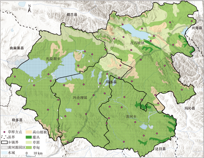
图1
玛多县草地样点分布与国家公园
Fig.1
Distribution of the grassland sampling sites and location of the Sanjiangyuan National Park in Maduo County
草地承载能力为在维持草地生态系统服务功能、保障生态安全[35]的条件下,既能满足自然保护又能满足经济社会发展需要的理论承载量。参考农业农村部《天然草地合理载畜量标准NY/T635—2015》《草食家畜羊单位换算NY/T 3647—2020》,草地承载能力计算公式为:
式中:Di是草地类型i的承载密度(SU/hm2),Ai是草地类型i的可利用面积(hm2),i为高寒草原、高寒草甸,Yi是草地年地上净初级生产力(kg/hm2),ei是可食牧草比例(%),Hi是标准干草转化系数,Ui是草地合理利用率,Gi是草地退化指数,
表1 玛多县草地承载力核算参数
Tab.1
| 关键参数 | 高寒草甸 | 高寒草原 | 数据来源 |
|---|---|---|---|
| 可利用草地(Ai,hm2) | 1764400 | 329000 | 中国1∶100万植被图 |
| 可食牧草干重(Fi,g/m2) | 118.7 | 88.3 | 样方调查+回归拟合 |
| 草地合理利用率(Ui) | 50% | 40% | NY/T 635—2015 |
| 草地退化指数(Gi) | 0.3 | 0.3 | NY/T 635—2015 |
| 标准干草折算系数(Hi) | 1 | 0.95 | NY/T 635—2015 |
注:可利用草地包括高寒草甸和高寒草原。
采用2022年7月20日Landsat影像,提取玛多县30 m归一化植被指数(NDVI),利用SPSS在样点尺度分高寒草甸、高寒草原建立可食牧草产量-NDVI回归模型(表2),模拟区域可食牧草产量。
表2 可食牧草产量F-NDVI回归方程显著性检验
Tab.2
| 草地类型 | 样点数n | 回归方程 | R2 | 回归系数显著性 |
|---|---|---|---|---|
| 高寒草甸 | 40 | F=22.192×exp(3.755× NDVI) | 0.452 | P<0.001 |
| 高寒草原 | 10 | F=32.931×exp(3.017× NDVI) | 0.461 | P=0.031 |
1.4 野生动物种群规模估计
图2
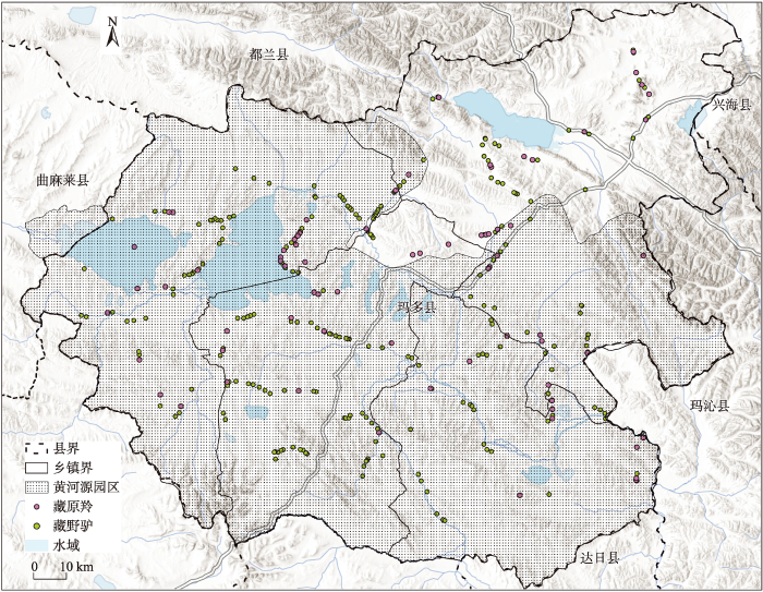
图2
玛多县藏野驴和藏原羚出现点位
Fig.2
Sites of presence of the Tibetan wild ass and gazelle in Maduo County
针对影响藏野驴、藏原羚分布的气候、地形、植被等16个环境变量①(①16个环境变量为:海拔Altitude(4000~5500 m)、坡度Slope(0°~15°)、NDVI(0~1)、与水源距离River(0~3 km)、年均气温Bio1(-15~5 ℃)、最热月最高气温Bio5(0~25 ℃)、最冷月最低气温Bio6(-35~-15 ℃)、最热季平均气温Bio10(0~25 ℃)、最冷季平均气温Bio11(-35~-15 ℃)、年均降水量Bio12(300~450 mm)、最湿月平均降水量Bio13(60~120 mm)、最干月平均降水量Bio14(0~25 mm)、最湿润季平均降水量Bio16(60~120 mm)、最干燥季平均降水量Bio17(0~25 mm)、最热季平均降水量Bio18(60~120 mm)、最冷季平均降水量Bio19(0~25 mm)。),提取野生动物出现点位的变量值,计算变量两两之间的Pearson相关系数,剔除相关系数大于0.75的变量[15],最后选取坡度Slope(°)、与水源距离River(km)、年均气温Bio1(℃)、最热月最高气温Bio5(℃)、最冷月最低气温Bio6(℃)、年均降水量Bio12(mm)、最湿月平均降水量Bio13(mm)、最干月平均降水量Bio14(mm)等8个变量作为种群密度估计的输入变量。采用最大熵模型(MaxEnt)、随机森林(random forest)模型估算藏野驴、藏原羚种群数量,采用受试工作特征曲线下面积(area under curve, AUC)进行精度验证[37]。
2 结果分析
2.1 草地承载能力
图3
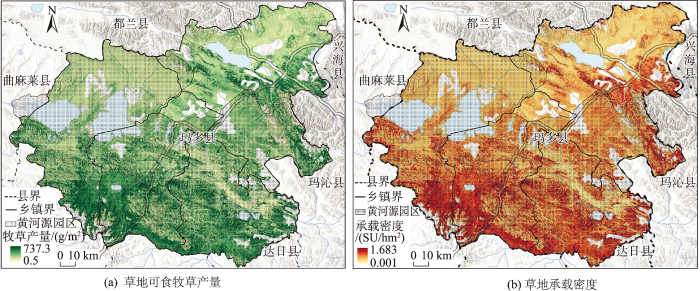
图3
玛多县草地可食牧草产量与承载密度
注:图中空白处为开发区、水域、灌丛、高山植被。
Fig.3
Yield of edible forage and carrying capacity density in Maduo County
表3 玛多县草地可食牧草产量
Tab.3
| 区域 | 高寒草甸 | 高寒草原 | |||||
|---|---|---|---|---|---|---|---|
| 面积/km2 | 牧草单产/(g/m2) | 牧草产量/t | 面积/km2 | 牧草单产/(g/m2) | 牧草产量/t | ||
| 花石峡镇 | 4737 | 106.5±62.3 | 504305 | 2169 | 91.8±42.6 | 199223 | |
| 扎陵湖乡 | 4357 | 103.9±63.2 | 452467 | 670 | 68.4±17.7 | 45801 | |
| 黄河乡 | 4318 | 130.5±70.3 | 563422 | — | — | — | |
| 玛查理镇 | 4232 | 135.6±67.9 | 573740 | 452 | 100.7±32.3 | 45491 | |
| 玛多县 | 17644 | 118.7±67.4 | 2093936 | 3290 | 88.3±38.9 | 290514 | |
玛多县平均草地承载密度为0.2524 SU/hm2,其中高寒草甸、高寒草原承载密度分别为0.2710、0.1532 SU/hm2。全县总草地承载力为52.85万SU,高寒草甸、高寒草原分别为47.81万、5.04万SU。玛查理镇、黄河乡高寒草甸承载密度约0.30 SU/hm2,扎陵湖乡、花石峡镇高寒草甸承载密度约为0.24 SU/hm2。玛查理镇、花石峡镇高寒草原承载密度约为0.16 SU/hm2,扎陵湖乡高寒草原承载密度约0.12 SU/hm2(表4)。
表4 玛多县高寒草地承载力
Tab.4
| 区域 | 高寒草甸 | 高寒草原 | 承载能力/SU | |||
|---|---|---|---|---|---|---|
| 承载密度±标准差/(SU/hm2) | 承载能力/SU | 承载密度±标准差/(SU/hm2) | 承载能力/SU | |||
| 花石峡镇 | 0.2431±0.1423 | 115138 | 0.1594±0.0739 | 34568 | 149707 | |
| 扎陵湖乡 | 0.2371±0.1442 | 103303 | 0.1187±0.0307 | 7947 | 111250 | |
| 黄河乡 | 0.2979±0.1606 | 128635 | — | — | 128635 | |
| 玛查理镇 | 0.3095±0.1551 | 130991 | 0.1748±0.0560 | 7893 | 138884 | |
| 玛多县 | 0.2710 | 478068 | 0.1532 | 50409 | 528476 | |
2.2 食草野生动物种群数量估计
据文献[38],AUC>0.9时模型模拟的精度较高,藏野驴、藏原羚密度预测模型的AUC分别为0.958、0.935(图4a、4b)。藏野驴和藏原羚的环境变量响应曲线显示(图4c、4d),两物种都偏好水资源丰富地区,当距离水源1 km、年均降水量(Bio12)达到350 mm,最湿月平均降水量(Bio13)为80 mm左右、最干月平均降水量(Bio14)约为14 mm时,两物种出现的概率都较大。两物种都倾向于温度较为适宜的地区,但藏原羚温度适应范围比藏野驴更广(Bio1、Bio5、Bio6)。两物种对坡度偏好存在差异,藏野驴偏好2°~5°的坡度,而藏原羚则适应于2°~8°。对1 km野生动物密度数据(图5)分区汇总显示:玛多县藏野驴、藏原羚密度分别为0.2157头/km2、0.1655只/km2,种群数量分别为5307头、4073只,食草野生动物合计相当于23264 SU(表5)。
图4
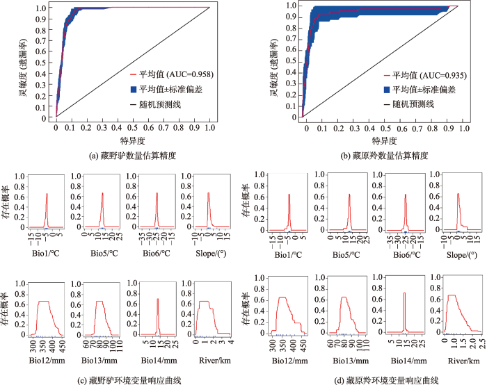
图5
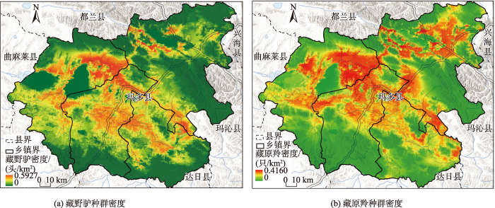
图5
玛多县藏野驴、藏原羚种群密度
Fig.5
Population density of Tibetan wild ass and gazelle in Maduo County
表5 玛多县藏野驴、藏原羚种群密度及数量
Tab.5
| 区域 | 藏野驴 | 藏原羚 | 食草野生动物 | |||||
|---|---|---|---|---|---|---|---|---|
| 密度/(头/km2) | 数量/头 | 密度/(只/km2) | 数量/只 | 密度/(SU/km2) | 数量/SU | |||
| 花石峡镇 | 0.1538±0.1535 | 1278 | 0.1549±0.1267 | 1288 | 0.6926 | 5757 | ||
| 扎陵湖乡 | 0.2446±0.1789 | 1572 | 0.1845±0.1181 | 1186 | 1.0706 | 6882 | ||
| 黄河乡 | 0.2271±0.1654 | 1058 | 0.1688±0.0977 | 786 | 0.9929 | 4627 | ||
| 玛查理镇 | 0.2685±0.1700 | 1398 | 0.1560±0.1311 | 812 | 1.1520 | 5998 | ||
| 玛多县 | 0.2157 | 5307 | 0.1655 | 4073 | 0.9454 | 23264 | ||
2.3 畜兽争草强度量化
2.3.1 畜兽争草相对强度
据玛多县农牧局数据,2014—2020年玛多县牲畜存栏量由13.18万降为12.75万头(只、匹),其中2018年存栏量接近多年平均水平。结合2018年末牲畜存栏量(34.21万SU)和食草野生动物现存量,玛多县畜兽争草相对强度为1/14.7。其中,玛查理镇、扎陵湖乡畜兽争草相对强度最大(约1/4),黄河乡畜兽争草相对强度较大(1/9.1),花石峡镇畜兽争草相对强度最小(1/42.5)(表6)。
表6 玛多县家畜及食草野生动物承载率及畜兽争草强度
Tab.6
| 区域 | 承载能力/SU | 放牧家畜 | 食草野生动物 | 综合承载率/% | 畜兽争草相对强度Irr | |||
|---|---|---|---|---|---|---|---|---|
| 实际存栏量/SU | 承载率/% | 种群数量/SU | 承载率/% | |||||
| 花石峡镇 | 149707 | 244725 | 163.5 | 5757 | 3.8 | 167.3 | 1/42.5 | |
| 扎陵湖乡 | 111250 | 28835 | 25.9 | 6882 | 6.2 | 32.1 | 1/4.2 | |
| 黄河乡 | 128635 | 42086 | 32.7 | 4627 | 3.6 | 36.3 | 1/9.1 | |
| 玛查理镇 | 138884 | 26423 | 19.0 | 5998 | 4.3 | 23.3 | 1/4.4 | |
| 玛多县 | 528476 | 342069 | 64.7 | 23264 | 4.4 | 69.1 | 1/14.7 | |
注:实际存栏是2018年年末数据。
2.3.2 放牧家畜承载率
2.3.3 食草野生动物承载率
2.3.4 家畜+食草野生动物承载率
考虑家畜和食草野生动物,玛多县草地综合承载率为69.1%(表6)。位于国家公园以内的扎陵湖乡、黄河乡、玛查理镇食草野生动物密度较高,野生动物承载率较高,家畜承载率较低,综合承载率较低。国家公园以外的花石峡镇野生动物密度较低,野生动物承载率较低,但家畜承载率很高,综合承载率达到167.3%,已属重度超载。
3 讨论与结论
3.1 讨论
3.1.1 基于种群数量调查的畜兽争草相对强度
以食草野生动物现存量与放牧家畜存栏量之比表征的畜兽争草相对强度指数越大,畜兽冲突强度越大。本文结果显示:玛多县藏野驴、藏原羚密度分别为0.2157头/km2,0.1655只/km2,种群数量分别为5307头、4073只。杨帆等[30]利用无人机航拍,估算玛多县2017年冷季藏野驴、藏原羚分别为17109头、15961只;Gao等[33]于2016—2017年采用样线调查,结合Maxent模型模拟,发现玛多县藏野驴、藏羚羊的密度分别为0.6432头/km2、0.2395只/km2,数量分别为12176头、4231只;李欣海等[39]于2014—2017年夏季进行了样线调查,结合随机森林模型,得到玛多县藏野驴、藏原羚分别为6436头、1077只;黄青东智等[36]于2020年冷季开展样线调查,估算出黄河源园区藏野驴、藏原羚的种群数量分别为2400~7632头、1765~3219只[36]。本文估计的野生动物种群规模低于杨帆等[30]、Gao等[33]的结果,与李欣海等[39]、黄青东智等[36]的结果接近。根据本文方法及数据计算,可知2015—2017年玛多县畜兽争草相对强度在1/4.5~1/7.3[25,30,33]。本文显示玛多县畜兽争草相对强度为1/14.7,畜兽争草强度有所下降。对照全球陆生野生哺乳动物与家畜的生物量之比(1/29)[40],可知研究区畜兽冲突强度仍较大。
3.1.2 基于草地承载率的畜兽争草绝对强度
以承载率(食草动物现存量与草地承载能力比值)表征的畜兽争草绝对强度指数越大,畜兽冲突强度越大。根据杨帆等[30]的研究,玛多县高寒草甸和高寒草原产草量分别为39.07、23.88 g/m2,可食牧草比例为0.6,草地承载密度为0.155 SU/hm2,全县承载力为34.46万SU。耿远月等[28]研究发现,三江源国家公园黄河源园区枯草期紫花针茅(Stipa purpurea)、垂穗披碱草(Elymus nutans)和冷地早熟禾(Poa crymophila)草原的承载力分别为0.35、0.34和0.10 SU/hm2。本文发现玛多县高寒草甸、高寒草原可食牧草产量分别为118.7、88.3 g/m2,草地承载力为0.2524 SU/hm2,高于杨帆等[30]、低于耿远月等[28]的结果。原因可能是,本文样方调查得到的可食牧草产量比例高于杨帆等[30]的0.6的经验值,耿远月等[28]则没有严格区分地上生物量和可食牧草产量。由于数据来源、研究方法的差异,不同研究得出的玛多县草地承载能力不尽相同。据青海省草原总站数据,1988、2012年玛多县草地载畜能力分别为105.21万SU、34.12万SU[41]。一些研究发现,玛多县草地承载能力为34.46万SU[30]、42.17万SU[33]、48.95万SU[25]。本文计算出的玛多县草地承载力为52.85万SU,考虑到近年草地保护的作用,承载力小幅增长比较可信。Ren等[25]研究认为,2015年玛多县家畜承载率为69.1%,藏野驴、藏原羚承载率为9.5%,综合承载率为78.6%(表7)。杨帆等[30]研究得到2017年冷季玛多县仅考虑家畜的承载率为112.9%,综合考虑家畜和野生动物的承载率为137.8%,属于中度超载。Gao等[33]研究认为,2013—2017年玛多县家畜承载率由84%下降到75%,野生动物承载率为12%,综合承载率为87%~96%。而本文研究得出,玛多县家畜承载率为64.7%,藏野驴、藏原羚草地承载率为4.4%,综合承载率为69.1%,草地承载压力不大(表7)。
表7 玛多县畜兽争草强度
Tab.7
| 指标 | 2015年 | 2017年 | 2017年 | 2022年 |
|---|---|---|---|---|
| 藏野驴/头 | 11397 | 17109 | 12176 | 5307 |
| 藏原羚/只 | 1545 | 15961 | 4231 | 4073 |
| 岩羊/只 | — | 9324 | — | — |
| 食草野生动物/SU | 46361 | 85741 | 50820 | 23264 |
| 放牧家畜/SU | 338159 | 389000 | 316762 | 342069 |
| 草地承载能力/SU | 489474 | 344600 | 421672 | 528476 |
| 畜兽争草相对强度Irr | 1/7.3 | 1/4.5 | 1/6.2 | 1/14.7 |
| 放牧家畜承载率/% | 69.1 | 112.9 | 75.1 | 64.7 |
| 食草野生动物承载率/% | 9.5 | 24.9 | 12.1 | 4.4 |
| 草地综合承载率/% | 78.6 | 137.8 | 87.2 | 69.1 |
| 数据来源 | 文献[25] | 文献[30] | 文献[33] | 本研究 |
3.2 结论
畜兽冲突强度量化是完善野生动物损害补偿制度的前提。基于调查数据、遥感数据及统计资料,采用野生动物样线调查、草地样方调查及模型模拟等方法,提出畜兽争草强度量化方法,为草原牧区畜兽冲突强度研究提供了一个可行路径。研究发现:2022年玛多县畜兽争草相对强度为1/14.7;家畜承载率为64.7%,藏野驴、藏原羚承载率为4.4%,综合考虑家畜和食草野生动物承载率为69.1%。2015年以来研究区草地承载率下降,畜兽冲突有所缓解,但争草强度仍然较大。玛多县位于国家公园内的乡镇,家畜承载率仅20%~40%、食草野生动物承载率4%~6%,家畜和食草野生动物综合承载率不足50%,草地承载率不高,但畜兽争草相对强度较大(>1/10),未来应进一步推动移民搬迁,完善野生动物损害补偿制度,强化国家公园在野生动物保护、环境教育与自然资源可持续利用方面的功能。国家公园周边的花石峡镇畜兽争草强度较小,但草地严重超载,未来应坚持走减畜增效、绿色发展之路。
参考文献
Assessment of conservation challenges in and around Gibe Sheleko National Park, southwestern Ethiopia
[J].
Research trends and management options in human-snow leopard conflict
[J].
Brown bear attacks on humans: A worldwide perspective
[J].The increasing trend of large carnivore attacks on humans not only raises human safety concerns but may also undermine large carnivore conservation efforts. Although rare, attacks by brown bears Ursus arctos are also on the rise and, although several studies have addressed this issue at local scales, information is lacking on a worldwide scale. Here, we investigated brown bear attacks (n = 664) on humans between 2000 and 2015 across most of the range inhabited by the species: North America (n = 183), Europe (n = 291), and East (n = 190). When the attacks occurred, half of the people were engaged in leisure activities and the main scenario was an encounter with a female with cubs. Attacks have increased significantly over time and were more frequent at high bear and low human population densities. There was no significant difference in the number of attacks between continents or between countries with different hunting practices. Understanding global patterns of bear attacks can help reduce dangerous encounters and, consequently, is crucial for informing wildlife managers and the public about appropriate measures to reduce this kind of conflicts in bear country.
Casualties of human-wildlife conflict
[J].
Human wildlife conflict involving large carnivores in Qilianshan, China and the minimal paw-print of snow leopards
[J].DOI:10.1016/j.biocon.2015.04.002 URL [本文引用: 1]
三江源国家公园牧民对野生动物容忍度研究
[J].
Research on tolerance of herdsmen to wild animals in Three-River-Source National Park
Human-elephant conflict in Asia
[R].
Willingness to pay for mitigating human-elephant conflict by residents of Nepal
[J].DOI:10.1016/j.jnc.2017.02.004 URL [本文引用: 1]
Human-elephant conflict in Xishuangbanna Prefecture, China: Distribution, diffusion, and mitigation
[J].
Wildlife conflict resolution: A review of problems, solutions and regulation in England
[J].
DOI:10.1071/WR10006
URL
[本文引用: 1]

Past hunter-gatherer societies are often perceived as having co-existed harmoniously with their environment. In reality, few ecosystems remain unaltered following the arrival of humans and the relationship between people and wildlife over the past thousand years is characterised more by conflict than harmony. Over this period, many industrialised countries, particularly in Europe, have seen a substantial loss of natural habitats, in parallel with huge increases in human populations. England is one such country; here, the human population is estimated to have increased 45-fold since 1066 AD. Over the past 50 years, however, many of these countries have witnessed a change in public attitudes, leading to ‘protective’ legislation for species and habitats, with the subsequent recovery of at least some species. As a result, some people now argue that certain species are ‘over-protected’, leading to calls to remove protection. We review how the regulatory system in England is used to achieve a sustainable balance between wildlife and human interests, illustrated with examples from key areas of conflict. In all, more than 8000 licences permitting activities affecting protected species are issued in England each year, about half of which concern human–wildlife conflicts, including almost 1000 aimed at preventing serious damage by wildlife. We estimate that wildlife licences are relied on by more than 100 000 people to resolve human–wildlife conflicts. In most cases, less than 1% of a species’ population is likely to be affected by regulated activities and, where this is not the case, thresholds are set to ensure the control measures do not lead to the long-term detriment of populations. We conclude by suggesting how the legislative framework may need to adapt to deliver modern aspirations to reconcile human and wildlife interests.
国家公园原住民对野生动物肇事的认知、意愿及其影响因素: 以武夷山国家公园为例
[J].
Local residents' cognition, willingness and influencing factors on wildlife conflict in national parks: A case study of Wuyishan National Park, China
Density of Tibetan antelope, Tibetan wild ass and Tibetan gazelle in relation to human presence across the Chang Tang Nature Reserve of Tibet, China
[J].
Causes of domestic livestock-wild herbivore conflicts in the alpine ecosystem of the Chang Tang Plateau
[J].
Identifying the environmental and anthropogenic causes, distribution, and intensity of human rhesus macaque conflict in Nepal
[J].
A future for all: The need for human-wildlife coexistence
[M].
Human-wildlife conflict pattern and suggested mitigation strategy in the Pamirs of Northwestern China
[J].DOI:10.1016/j.rama.2018.07.011 URL [本文引用: 2]
Geospatial analysis of alarmingly increasing human-wildlife conflicts in Jim Corbett National Park's Ramnagar buffer zone: Ecological and socioeconomic perspectives
[J].DOI:10.1016/j.ijgeop.2022.06.002 URL [本文引用: 1]
EIP-AGRI Focus Group Wildlife and agricultural production: Final report
[R].
Addressing human-tiger conflict using socio-ecological information on tolerance and risk
[J].Tigers are critically endangered due to deforestation and persecution. Yet in places, Sumatran tigers (Panthera tigris sumatrae) continue to coexist with people, offering insights for managing wildlife elsewhere. Here, we couple spatial models of encounter risk with information on tolerance from 2386 Sumatrans to reveal drivers of human-tiger conflict. Risk of encountering tigers was greater around populated villages that neighboured forest or rivers connecting tiger habitat; geographic profiles refined these predictions to three core areas. People's tolerance for tigers was related to underlying attitudes, emotions, norms and spiritual beliefs. Combining this information into socio-ecological models yielded predictions of tolerance that were 32 times better than models based on social predictors alone. Preemptive intervention based on these socio-ecological predictions could have averted up to 51% of attacks on livestock and people, saving 15 tigers. Our work provides further evidence of the benefits of interdisciplinary research on conservation conflicts.
自然保护地人兽冲突管理现状、挑战及建议
[J].
Current status, challenges, and advices of human wildlife conflict management in protected areas
三江源区生态承载力与生态安全评价及限制因素分析
[J].
An assessment and analysis of constraint factors on ecological carrying capacity and ecological security for the Sanjiangyuan region
Determination of resource based stocking density of wild ungulates living in the floating meadows of Keibul Lamjao National Park, India
[J].DOI:10.1016/j.chnaes.2018.11.008 URL [本文引用: 2]
Patterns of guanaco distribution and microhabitat use in Tierra del Fuego: From protected to sheep ranching areas
[J].
Optimizing livestock carrying capacity for wild ungulate-livestock coexistence in a Qinghai-Tibet Plateau grassland
[J].Wild ungulates are an important part of terrestrial ecosystems and play a critical role in maintaining ecosystem health and integrity. In many grassland ecosystems that are habituated by wild ungulates, the coexistence of domestic ungulates has created a conflict over grazing resources. Solving this conflict requires a balanced and sustainable policy that satisfies both the needs of wildlife protection and food production. Here, we assess the optimal grassland livestock carrying capacity of an alpine grassland on the Qinghai-Tibet Plateau, given the coexistence of wild populations of kiangs (Equus kiang) and Tibetan gazelles (Procapra picticaudata), two key species grazing in this region. We use kriging and the MaxEnt method to estimate the population sizes of kiangs and Tibetan gazelles in Maduo County, Qinghai Province. We then convert the estimated population size of the two species into sheep units and calculate the residual carrying capacity for livestock grazing. We show that after accounting for the grazing need for kiangs and Tibetan gazelles, grassland in Maduo is capable of supporting 420,641 sheep units, which is slightly more than the current livestock population. However, the residual carrying capacity is highly uneven across the region, and overgrazing is found in many areas of Maduo, especially in northern Maduo. This research provides a useful framework for planning sustainable livestock farming for the Qinghai-Tibet Plateau and other regions facing wildlife-livestock conflict.
三江源国家公园长江源园区人熊冲突现状与牧民态度认知研究
[J].
The human-bear conflicts and herder attitudes and knowledge in the Yangtze River Zone of Sanjiangyuan National Park
我国自然保护区人与野生动物冲突现状及管理建议
[J].
Current situation and management suggestions of human-wildlife conflict in nature reserves in China
黄河源园区典型高寒草原牧草营养特征及家畜承载力研究
[J].
DOI:10.11733/j.issn.1007-0435.2022.07.025
[本文引用: 4]
三江源国家公园地处青藏高原腹地,是国家重要的生态资源资产区,生态战略地位十分突出。本研究选择黄河源园区3种典型高寒草原,测定不同季节牧草的养分供给状态并计算家畜承载力,为实现黄河源园区草畜平衡提供数据支撑。结果表明:不同季节的植被数量特征、牧草营养特征和承载力表现为:紫花针茅(Stipa purpurea)草原和垂穗披碱草(Elymus nutans)草原显著高于冷地早熟禾(Poa crymophila)草原;从生态保护的角度出发,紫花针茅、垂穗披碱草和冷地早熟禾草原盛草期的家畜承载力分别为1.72 SHU·hm<sup>-2</sup>,1.41 SHU·hm<sup>-2</sup>和1.18 SHU·hm<sup>-2</sup>;枯草期的家畜承载力分别为0.35 SHU·hm<sup>-2</sup>,0.34 SHU·hm<sup>-2</sup>和0.10 SHU·hm<sup>-2</sup>。综上所述,紫花针茅草原可以为黄河源园区提供更多的牧草养分。结合放牧家畜对牧草的营养需求,建议根据牧草产量和营养的季节动态,优化草畜资源空间配置。
Study on nutrient characteristics of herbage and carrying capacity of livestock on typical alpine steppe in Yellow River Source Park
DOI:10.11733/j.issn.1007-0435.2022.07.025
[本文引用: 4]
Sanjiangyuan National Park is an important national ecological resource asset area with prominent ecological strategic position,which is located in the hinterland of the Qinghai-Tibet Plateau. In this study,three typical alpine grasslands in the Yellow River Source Park were selected to determine the nutrient supply status of forage in different seasons and calculate the livestock carrying capacity to provide the supporting data for realizing the balance of grass and livestock in the Yellow River Source Park. The results showed that the quantitative characteristics of vegetation,herbage nutritional characteristics and carrying capacity in different seasons were as follows:<i>Stipa purpurea</i> grassland and <i>Elymus nutans</i> grassland were significantly higher than <i>Poa crymophila</i> grassland;From the perspective of ecological protection,the livestock carrying capacity of <i>Stipa purpurea</i>,<i>Elymus nutans</i> and <i>Poa crymophila</i> grassland were 1.72 SHU·hm<sup>-2</sup>,1.41 SHU·hm<sup>-2</sup> and 1.18 SHU·hm<sup>-2</sup>,respectively,during the flourishing period;0.35 SHU·hm<sup>-2</sup>,0.34 SHU·hm<sup>-2</sup>and 0.10 SHU·hm<sup>-2</sup>,respectively,during the withering period. To sum up,<i>Stipa purpurea </i>grassland could provide more forage nutrition for the Yellow River Source Park. Combined with the nutritional needs of grazing livestock for forage,it recommended that the spatial allocation of forage and livestock resources should be optimized according to the seasonal dynamics of pasture production and nutrition.
草场细碎化如何影响牧户实现草畜平衡: 以内蒙古与青海典型牧区为例
[J].
How does the fragmentation of pasture affect herders' balance between grass and livestock?
玛多县大型野生食草动物种群数量对草畜平衡的影响研究
[J].
DOI:10.11686/cyxb2017311
[本文引用: 12]
以黄河源区玛多县为研究区域,利用无人机遥感技术调查了县域内藏野驴、藏原羚、岩羊等大型野生食草动物和家畜的种群数量,利用降尺度算法生成了2016年玛多县30 m空间分辨率的产草量数据,在此基础上估算了包括野生动物和家畜在内的草畜平衡状况,分析了大型野生食草动物对玛多县草畜平衡的影响。结果表明:1)通过飞行样带内种群密度,推算了玛多县内大型食草动物种群数量,分别与统计数据、暖季调查结果对比验证,估算出2017年冷季藏野驴、藏原羚和岩羊分别为1.71、1.60和0.93万匹(只),家牦牛、藏羊和马分别为7.08、10.22、0.12万头(匹、只),大型野生食草动物和家畜总计47.5万羊单位,大型野生食草动物羊单位数量与家畜羊单位数量之比为1∶4.5;2)仅考虑饲养家畜,载畜压力指数为1.13,表明草地略微超载;在综合考虑饲养家畜和野生动物的情况下,载畜压力指数为1.38,表明草地中度超载;3)若没有将大型野生食草动物纳入草畜平衡核算体系内,载畜压力将被低估22%。超载过牧是造成玛多县草地退化一个主要驱动因素,需人工补饲7.90万t干草或减畜30%才能维持草畜平衡。
Effects of wild large herbivore populations on the grassland-livestock balance in Maduo County
DOI:10.11686/cyxb2017311
[本文引用: 12]
The number of wild large herbivores, including <em>Equus kiang</em>, <em>Procapra picticaudata</em> and <em>Pseudois nayaur</em> was investigated using remote sensing technology or an unmanned aerial vehicle (UAV). The balance of grassland-livestock, including wild and domestic herbivores, was estimated from data (30 m resolution) in Maduo County in 2016 and the effects of wild herbivore population on the balance of grassland-livestock analyzed. The population of large herbivores was estimated from animal density from sample flights, and the results compared with data from summer monitoring. The estimated number of <em>E. kiang</em>, <em>P. picticaudata</em> and <em>P. nayaur</em> were 1.71, 1.60 and 0.93 million respectively, while the number of yak, Tibetan sheep and horses were 7.08, 10.22 and 0.12 million respectively. The number of large wild herbivores present was equivalent to 47.5 million sheep stock units. The ratio of sheep stock units from wild herbivores to the number of domestic herbivores was 1∶4.5. The carrying capacity index of domestic livestock was 1.13, indicating that the grassland was slightly overstocked; the carrying capacity index for wild herbivores was 0.25 and the combined carrying capacity index (1.38) indicated that the grassland was overstocked. Not including wild herbivores in the grassland-livestock balance accounting system resulted in the carrying capacity index being underestimated by 22%. Overstocking is one of the main drivers of grassland degradation in Maduo County; feeding of 79000 tons of hay or reducing livestock numbers by 30% would be required to achieve balance.
三江源国家公园兽类物种多样性及区系分析
[J].
Species diversity and fauna of mammals in Sanjiangyuan National Park
羌塘高原人与野生动物冲突的成因
[J].
DOI:10.31497/zrzyxb.20190714
[本文引用: 1]
随着自然保护事业的发展,人与野生动物冲突加剧成为自然保护与地区发展面临的新问题。但人与野生动物冲突研究具有多主体性、复杂性和跨学科性,研究难度大。本文以羌塘高原为例,采用人与野生动物相互作用社会生态系统的概念,梳理了人与野生动物冲突主体的规模、分布,识别了食草野生动物与家畜争食牧草、人类聚落与野生动物竞争生存空间、草场围栏分隔栖息地及阻断迁徙通道等三种主要冲突类型。考虑草畜兽平衡核算了草地承载状况,模拟了家畜与野生动物生存空间重叠,刻画了草场围栏对栖息地及迁徙通道的影响。从重叠空间的资源竞争及人类活动扰动等方面剖析了人与野生动物冲突成因。可为厘清冲突机制,提高干预效果提供新认知。
Causes for human-wildlife conflict on Changtang Plateau in Tibet
DOI:10.31497/zrzyxb.20190714
[本文引用: 1]
With the great progress of nature conservation in the last decades, human-wildlife conflict (HWC) has emerged as a new issue regarding protected areas. It is important to understand the causes for HWC and take effective measures to reduce HWC. However, research on HWC, characterized by systematicity, complexity, composed by multi-agents, and having feedback mechanism among agents, is difficult for us. Taking the Changtang Plateau in Tibet as an example, with the concept of social-ecological system of human-wildlife interactions, the distribution and quantity of agents of HWC is illustrated by field survey, statistical data and remote sensing data. Three main types of HWC in the study area is identified: (1) Forage competition between domestic livestock (sheep, goats and domestic yak) and herbivore wildlife (<em>Pantholops hodgsonii</em>, <em>Equus kiang</em>, <em>Procapra picticaudata</em>, <em>Gazelle</em>); (2) Living space competition between human settlements and wildlife habitats; (3) Fence separated the pasture and blocked the migratory routes of wildlife like Tibetan antelope. The pasture carrying capacity is examined by integrating wildlife with domestic livestocks. The overlaying of grazing pasture with wildlife habitat was modelled with the Maxent niche model and analyzed with the aid of GIS (geographic information system). Carrying capacity rate including both domestic livestock and herbivore wildlife was 110%, while domestic livestock stock rate was only 98%. Spatial overlapping rate was more than 50% for Tibetan antelope and domestic livestock. The impact of fence on habitat and migratory route of wildlife is also analyzed. Finally, causes for HWC are assembled from the aspects of the resource competition, the overlaying of living space, and the disturbance from human activities such as fence. The study is helpful to clarify the HWC cause and formation mechanism, and to improve the performance of conflict reduction measures.
The carrying pressure of livestock is higher than that of large wild herbivores in Yellow River source area, China
[J].
围栏封育对黄河源区退化高寒草地植被组成及生物量的影响
[J].
DOI:10.11733/j.issn.1007-0435.2012.02.012
[本文引用: 1]
在黄河源区-青海省果洛藏族自治州玛沁县选取4个不同退化程度的天然草地,以围栏内封育和围栏外自由放牧草地作比较,采用样方法调查草地围栏内外的群落结构特征和草地初级生产力生物量,并通过计算地上与地下生物量比值以及植物群落干鲜比来评价围栏封育的效果。结果表明:不同退化程度围栏内外的植被组成存在显著差异;随着退化程度的加剧,植物群落的盖度、高度以及多样性指数有下降趋势,且围栏内的盖度、高度及多样性指数均大于围栏外的;植物群落高度、盖度、地上生物量和生物量干鲜比随着退化程度加剧有减小的趋势。围栏封育有利于改善青藏高原退化高寒草地的植物群落结构,提高草地植物群落的盖度和生物量,促进其恢复演替。
Effect of grassland enclosure on vegetation composition and production in headwater of Yellow River
DOI:10.11733/j.issn.1007-0435.2012.02.012
[本文引用: 1]
The plant community structure and primary production of the alpine grasslands under different degradation degrees were investigated in Maqin County of Qinghai Province,the headwater area of Yellow River.The structure of the plant community had significant variation relating grassland degradation with fencing.The coverage and height of plants inside fences were higher than those outside fences and declined with the increase of degradation degrees.Similar results were found for the plant diversity index.The aboveground biomass,coverage and height of the grassland along degradation gradients showed a declining trend.These parameters were significantly higher in the fenced grasslands than the unfenced ones.Aboveground biomass/underground biomass ratios of the grassland were decreased by degradation and increased by fencing.The ratios of dry to fresh weight of aboveground biomass declined with the increase of degradation degree and increased after fencing.It can be concluded that grassland enclosure is a feasible approach to restore grassland vegetation in the headwater areas of the Qinghai-Tibetan Plateau.Plant cover,plant biomass and species biodiversity can be used as indicators to assess grassland restoration intervention.
区域生态承载力预警评估方法及案例研究
[J].
DOI:10.18306/dlkxjz.2017.03.005
[本文引用: 1]
本文针对国家资源环境承载能力监测预警评估中生态承载力评估的需求,探讨了生态承载力及预警的定义与内涵,从预警角度提出区域生态承载力评价的内容与方法,并以京津冀地区为例开展了案例研究。主要结论为:生态承载力是指生态系统提供服务功能、预防生态问题、保障区域生态安全的能力。生态承载力预警评估的实质是评估人类活动是否及在多大程度上影响生态系统在水源涵养、水土保持、防风固沙等主要服务功能的提供,是否产生了生态环境问题,是否影响到区域的生态安全。其评价流程主要包括:区域生态承载力评价指标选取及评价方法和阈值的确定、生态承载力预警状况及变化趋势分析、成因解析等内容。本文提出的生态承载力预警评价的方法及案例,可为全国及区域生态承载力的评估提供基础。
Evaluation methods and case study of regional ecological carrying capacity for early-warning
DOI:10.18306/dlkxjz.2017.03.005
[本文引用: 1]
Based on the national needs for resources and environment carrying capacity monitoring and early-warning, this article addresses the definition of ecological carrying capacity and its evaluation method for early-warning. A case study was carried out for the Beijing-Tianjin-Hebei region. The article concludes that ecological carrying capacity refers to the ability of ecosystems in providing ecosystem services, preventing ecological problems, and ensuring ecological security. Ecological carrying capacity evaluation for early-warning is to examine the extent of human disturbances that affect ecosystem services supply with regard to water retention, soil retention, sandstorm prevention; produce ecological problems; and affect regional and national ecological security. The main procedures involve indicator and evaluation method selection, threshold identification, status and trend analysis of ecological carrying capacity with reference to early-warning threshold, and cause analysis. The method and case study of ecological carrying capacity evaluation for early-warning proposed in this study can serve as a basis for regional and national assessment.
道路对三江源国家公园黄河源园区藏野驴和藏原羚种群数量及其栖息地的影响
[J].
DOI:10.16829/j.slxb.150567
[本文引用: 4]
为探究道路对三江源国家公园黄河源园区藏野驴(Equus kiang)和藏原羚(Procapra picticaudata)种群数量及其栖息地的影响,于2020年冷季采用截线取样法在黄河源园区进行实地调查。通过设置4种不同等级的道路情景,使用MaxEnt模型评价藏野驴和藏原羚的生境适宜性,模拟了不同等级道路变量情景下两种有蹄类动物的适宜栖息地。并根据适宜栖息地面积和R程序的Distance包估算了藏野驴和藏原羚种群密度及数量。结果显示,调查样线总长1 320.63 km,发现藏野驴2 231头,藏原羚822只。估算藏野驴的种群密度为每平方千米(1.18 ±0.34)头,种群数量为2 400~7 632头;藏原羚的种群密度为每平方千米(0.94 ±0.14)只,种群数量为1 765~3 219只。MaxEnt模型预测结果表明,藏野驴和藏原羚适宜栖息地面积分别为3 641.34 km2和2 525.18 km2,分别占整个黄河源园区的19.2%和13.3%。影响藏野驴分布的主要环境因子依次为:距低等级公路的距离、年降水量、海拔和归一化植被指数。影响藏原羚分布的主要环境因子依次为:距低等级公路的距离、海拔、坡向和坡度。两种有蹄类动物重叠的适宜栖息地面积为2 240.15 km2,分别占藏野驴适宜栖息地的61.5%和藏原羚适宜栖息地的88.7%,且二者的适宜栖息地主要分布在黄河源园区的中部。不同道路情景模拟结果显示:(1)相比于不含道路变量的情景,道路存在的3种情景会使两种有蹄类动物的栖息地出现不同程度的丧失,种群数量也随之出现不同程度的下降。不含道路变量的情景时,两种有蹄类动物适宜生境面积最大,种群数量也最大;含全部道路变量的情景时,两种有蹄类动物适宜生境面积最小,种群数量也最小,栖息地丧失的比例最大,分别为27.2%和42.3%。(2)不同等级道路对二者的栖息地面积和种群数量影响程度不同,与高等级公路相比,低等级公路会使两个物种丧失更大的栖息地面积,种群数量下降更多。(3)两个物种对道路干扰的响应不同,在不同道路情景下,藏原羚会丧失更大比例的栖息地面积,种群数量下降幅度更大。本研究通过量化评估不同等级道路对有蹄类动物栖息地和种群数量的影响,为高原有蹄类物种的保护与道路的管理规划提供科学依据。
Effects of roads on the abundance and habitat of Tibetan wild ass and Tibetan gazelle in the Yellow River Source Zone of Sanjiangyuan National Park
DOI:10.16829/j.slxb.150567
[本文引用: 4]
We sought to understand the effects of roads on the populations and habitat of Tibetan wild ass (Equus kiang) and Tibetan gazelle (Procapra picticaudata) in the Yellow River Source Zone of Sanjiangyuan National Park. We conducted a field survey to estimate population size, density and distribution of Tibetan wild ass and Tibetan gazelle in the region in autumn 2020 using a line transect sampling method. We then used the MaxEnt to assess habitat suitability of the two species under four different scenarios of road density and road type. The total length of the survey line was 1 320. 63 km, along which 2 231 Tibetan wild asses and 822 Tibetan gazelles were observed. The density of Tibetan wild ass was (1. 18 ±0. 34) individuals/km2 and the estimated abundance ranged from 2 400 to 7 632. The density of Tibetan gazelle was (0. 94 ±0. 14) individuals/km2 and the estimated abundance ranged from 1 765 to 3 219. MaxEnt predicted that the suitable habitat areas of Tibetan wild ass and Tibetan gazelle were 3 641. 34 km2 and 2 525. 18 km2, accounting for 19. 2% and 13. 3% of the entire Yellow River Source Zone, respectively. Distance to low-grade roads, annual precipitation, altitude and normalized difference vegetation index were the most important factors affecting habitat suitability for Tibetan wild ass.Distance to low-grade roads, altitude, aspect and slope were the most important factors affecting habitat suitability for Tibetan gazelle. The overlapping suitable habitat area of the two species was 2 240. 15 km2, accounting for 61. 5% and 88. 7% of the suitable habitat of Tibetan wild ass and Tibetan gazelle, respectively. The suitable habitats of Tibetan wild ass and Tibetan gazelle in autumn were mainly distributed in the central part of the Yellow River Source Zone. The road scenarios analysis indicated that:(1) the three scenarios including road variables resulted in varying degrees of habitat area loss and consequent population declines for both species when compared to the scenario with no roads. Scenarios with all road variables resulted in the smallest area of suitable habitat and the smallest populations for both species with 27. 2% and 42. 3% of suitable area lost for Tibetan wild ass and Tibetan gazelle respectively. (2) Different types of roads have different degrees of influence on the habitat area and populations of the two species. Low-grade roads cause greater habitat area loss and greater population declines for both species compared to highgrade roads. (3) The two species respond differently to road disturbance, with Tibetan gazelle suffering a greater loss of suitable habitat and experiencing a greater reduction in population size. This study provides evidence for ungulate conservation and roads managed on the Qinghai-Tibetan Plateau by quantitatively assessing the effects of different types of roads on the habitats and populations of two ungulate species.
Estimation of the Tibetan wild ass population in Gaize County of Chang Tang Plateau based on the belt transect method and random forest model
[J].
DOI:10.5814/j.issn.1674-764x.2022.05.010
[本文引用: 1]
As a typical representative of the herbivorous wild animals in Chang Tang Plateau, the number of Tibetan wild asses has increased significantly in recent years. Clarifying the distribution, population, and size of its habitats is conducive to formulating the protection plan for wild animals and managing the conflict between people and wild animals in Chang Tang Plateau. Based on the distribution probability of Tibetan wild ass habitats and environmental factors, the number of Tibetan wild asses in Gaize County of Chang Tang Plateau was calculated by using the belt transect method and random forest model, and due to the uncertainty of the calculations, the results were corrected and analyzed. The results show that the living environment of Tibetan wild asses in Gaize County of Chang Tang Plateau is at 4400-4600 m above sea level, 350-400 m away from the river, and the average temperature in the warmest season is 10-12 ℃. The vegetation types of habitats are generally temperate tufted dwarf grass, dwarf semi shrub desert grassland, alpine grass, Carex grassland, alpine cushion dwarf semi shrub desert, among others. On the basis of studying the environmental preferences of Tibetan wild asses, the random forest model was corrected by using the data of the second scientific survey sample line of Qinghai-Tibet Plateau for three years. The approximate number of Tibetan wild asses in each of the different areas of Gaize County was obtained. The number of Tibetan wild asses in Gaize Town, Xianqian Township, Gumu Township, Chabu Township, Mami Township, Wuma Township and Dongcuo Township is 855, 3458, 2358, 1453, 743, 943 and 647, respectively. By studying the environmental preferences of Tibetan wild asses and analyzing the results of the belt transect survey, the random forest model can accurately estimate the number of Tibetan wild asses in Gaize County of Chang Tang Plateau.
基于AUC的分类器评价和设计综述
[J].尽管精度(或总体错分率)普遍用作分类算法的性能评价指标,但存在诸如敏感于类先验分布和错分代价,忽略分类算法所得的后验概率或排序信息等不足。而接收者操作特性(ROC)曲线下面积则能度量算法在整个类先验分布及错分代价范围内的总体分类性能、后验概率和排序性能,因此在分类学习中受到越来越多的关注,由此涌现出众多研究成果。文章旨在对此作相对全面的回顾和总结,包括AUC作为性能评价指标的优势所在,基于AUC优化的算法设计,基于精度优化和AUC优化的算法间的关系以及AUC存在的不足及改进。
A survey of evaluation and design for AUC based classifier
Though as a common performance evaluating index for classification algorithms, accuracy (or total misclassification error) has several deficiencies, such as the sensitivity to class prior distribution and misclassification costs, and the ignorance of the posterior probability and ranking information obtained by classification algorithms. While the area under the receiver operation characteristic (ROC) curve measures the classification performance across the entire range of class prior distribution and misclassification costs, as well as the probability and ranking performance. Thus, it attracts much attention in classification learning and evokes a lot of researches. In this paper, a relative comprehensive survey for these researches is presented, including the advantages of AUC as a performance evaluating index, the design of algorithms based on AUC, the relationship between the accuracy-maximizing and AUC-maximizing algorithms and the deficiencies of AUC along with its variants.
用物种分布模型和距离抽样估计三江源藏野驴、藏原羚和藏羚羊的数量
[J].
Estimating abundance of Tibetan wild ass, Tibetan gazelle and Tibetan antelope using species distribution model and distance sampling
DOI:10.1360/N052018-00171 URL [本文引用: 2]
Wild mammals add up to a 'shockingly tiny' total biomass
[J].Humans and domestic species far outweigh other mammals.
青海省玛多县草地类型面积、载畜量统计数据(1988, 2012)
[DB/OL].
Statistical data of grassland type, area and livestock carrying capacity in Maduo County, Qinghai Province (1988,2012)
