

自然景观美学被认为是一种重要的生态系统服务功能(文化服务功能),对人类健康和福祉具有显著的积极影响[1-2]。在高质量的自然景观环境中,可使人们获得愉悦的心情和积极的情绪、提高认知能力,促进儿童的智力和运动发育等[3]。因其在土地利用、生态环境规划、管理和保护中的作用,景观美学价值评估逐渐得到认可并成为重要的政策工具,如《世界遗产公约》和《欧洲景观公约》等[4],从而越来越受到学术界和决策管理部门的高度关注。青藏高原自然景观资源极为丰富,近年来国内外游客规模快速增长,仅西藏2000—2019年旅游人次便从379万迅猛增长至3958万,旅游业已经成为带动当地经济发展的支柱性产业。此外,目前青藏高原正在大力推进国家公园群建设,旨在严格保护脆弱生态环境的同时发挥生态旅游的经济价值,实现生态保护与地区发展的协同[5-6]。其中,关键问题包括大尺度景观价值的空间分布、景点和旅行路线的优选与管理决策以及如何规避可能带来的生态风险。显然,在区域性尺度开展景观美学价值评价对解决上述问题具有基础性的作用,一方面充分利用景观美学价值作为观景点和景观路线规划的指引,另一方面将景观美学价值评价与地区生态脆弱性相结合,有助于决策者科学地进行生态系统服务功能的空间权衡。
关于景观美学的探索由来已久,但相关实践评估成果主要集中于国外研究。学者们从美的本质开始探索,认为景观只是众多审美对象之一,是主体感知到的空间场域[7],强调景观的物质要素和实体形态。由于大部分景观美感是通过视觉信号传导的,因而对于视觉感知的景观美学价值评价方法研究成果最为丰硕[8]。基于景观偏好(感知)的评估思路是运用最早也是最为广泛的路径,核心是将景观的生物物理特征与人们主观审美偏好进行联系,探索人们在不同景观场景中对特定有形景观的感知[9-10]。最常见的具体方法是对照片评价,使用风景照片作为真实风景体验的替代品[11],评价主体既可以是专家,也可以是居民或游客,而感知标准受到不同人群的文化和价值观影响[12-13]。许多研究侧重于对特定景观的分析,如森林、海岸带、农业、河流、高山峡谷、雪山、城市公园等[14]。近年来,随着景观生态学理论的完善,同时考虑到空间尺度的差异,为了更客观、更广泛、更具可比性的方式来评估景观美学价值,景观美学被纳入生态系统服务框架中作为文化服务类型,景观格局、功能及景观多样性等是影响景观美学价值的重要维度[8,15]。通过科学手段获取公众普遍认同的景观因子[16],如土地利用因子,其不同类型、结构和组合模式是促进景观感知和价值形成的重要信息来源[17],从而建立起景观美学评价量化的指标体系,采用GIS等分析手段,将表征物理属性的地理数据空间化进行景观美学价值评估[18]。这实现了从特定地方到区域尺度的评估,以及不同地区的可比性,从而更好地支撑地方和区域尺度开展游憩规划与公共管理决策[19]。
相较于国外研究成果,国内的景观美学价值评估起步较晚,在评估方法、指标体系和空间尺度的多样性融合等方面还存在着较大的差异[8,20]。国内评估方法偏向于主观性较强的景观偏好(感知)途径,研究对象偏向于单一类型或小尺度景观。显然,西藏具有大尺度空间、景观类型多样化的特征。在这样的区域开展自然景观美学价值的科学评估,国内学者还鲜有探讨,而且已有的相关评价模型和方法也难以适用。因此,本文基于生态系统服务视角,从自然性、多样性和独特性3个维度构建自然景观美学价值评估指标体系,融合多源数据对西藏进行综合评估,以期为区域层面的景观价值评估方法研究以及西藏旅游发展与生态保护、国家公园建设与管理等方面提供有益参考。
1 研究区域
西藏自治区总面积为122.8万km2,约占中国总面积的1/8,东处于横断山脉,西连克什米尔高原,北靠昆仑山—唐古拉山脉,南部横亘喜马拉雅山脉。地处北半球中纬度地带,区域平均海拔超过4000 m,空气稀薄,太阳辐射强烈,但气温低且日较差大,气温随高度和纬度的升高而降低,年平均气温由东南的20 ℃,向西北递减至-6 ℃以下。降雨量也少,且空间分布极为不均匀,由于南部的海洋暖湿气流受多重高山阻留,年降水量也相应由2000 mm递减至50 mm以下。作为“亚洲水塔”和世界生物多样性保护的热点,同时又因为脆弱的生态系统非常容易受到干扰,因而受到了广泛关注[21]。与此同时,在广袤的高原上,拥有高山、深谷、冰川、湖泊、森林、草原等类型丰富、景观独特的地形地貌和生态系统,构成了全球罕见的自然景观资源,成为极具吸引力的世界旅游目的地。生态地理区划中,西藏被分为7个大区[22],分别是昆仑山高寒荒漠草原生态区、藏北高原高寒荒漠草原生态区、那曲高寒草甸草原生态区、阿里山地温性干旱荒漠生态区、藏南山地高寒草甸草原生态区、藏东寒温性针叶林生态区、藏东南热带雨林季雨林生态区(图1)。
图1
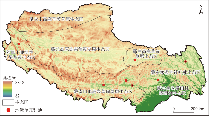
图1
西藏生态分区与地理概况
注:该图基于自然资源部标准地图服务网站下载的审图号为GS(2020)4619号标准地图制作,底图无修改。下同。
Fig.1
Ecological zoning and geographical overview of Tibet
2 方法与数据
2.1 概念内涵及评估视角
景观这一概念涉及多个学科领域,尽管学术界对其定义未达成共识,但通常认为景观是由各类土地单元镶嵌而形成的地理实体,具有明显的主观视觉特征的生态系统功能,可通过广泛的服务来提高人们的生活质量,包括美学价值、户外休闲机会、水和气候调节等[23]。美学则是一个接近艺术哲学的宽泛而模糊的概念,景观美学被理解为特定地点的“感官参与和享受”[7],通常是指视域范围内所呈现的景象,更多具有视觉美学方面的意义,这与文化传统、感官特征或人类意识的进化印记相关[24]。另外,根据心理物理学基础,一些学者从客观世界的自然特征出发探索美的本质,将其根源归结为自然事物本身的某种感性特征和属性,建立起了基于物理属性的地理数据,进行景观美学价值的映射[25]。因而,对其空间可视评估形成了从景观偏好视角和景观内在属性出发两种不同研究范式[26]。景观偏好视角往往以访谈、问卷调查、实验、观察、参与制图等方法研究人们对特定区域的看法和偏好[27-28]。景观内在属性视角以公众对某些景观特征的一般感知、专家评估、文献推断等为基础,通过获得公众普遍认同的景观因子建立评价指标体系,采用空间分析和可视化手段,将表征物理属性的地理数据空间化进行景观美学价值评估[14,29]。显然,具体的方法选择与评价单元的空间尺度密切相关[20]。单独采用景观偏好视角的评价方法,工作量大且非常耗时,往往适宜于地方小尺度空间和特定景观;而对于面积广阔、地理特征复杂性更高的大尺度空间往往更加依赖于相对抽象和简化的景观内在属性视角。
2.2 区域尺度的评估框架
关于区域尺度的景观美学价值评价,基于生态系统服务视角开展指标体系构建的客观评价方法是目前国际前沿的研究热点。景观美学作为一种文化生态系统服务,其功能大小取决于生态环境条件,包括植被条件、地表覆被、地形条件、独特景观等要素。Hermes等[30]、Kalinauskas等[14]把这些要素归纳为景观多样性、自然性和独特性,将其作为评估景观美学价值的多维度视角,建立起了科学完整的框架(LAQ)。自然性强调景观在演变过程中始终保持原始的、不受干扰的状态,认为人类干扰程度越高,自然度越低[31]。多样性强调由不同类型景观要素或生态系统构成的空间结构、功能机制的多样化或变异性[29]。独特性强调在更大的空间尺度下考虑景观的稀有性特征,具备较高审美价值和娱乐价值的潜力[32]。该方法已经在德国、立陶宛等国家尺度上进行了运用[14,30],并取得了较好的效果。西藏的面积远大于这两个国家,因而从数据精度要求和空间分析的可行性来说,该方法对于西藏具有较好的适用性。在借鉴LAQ评估框架的基础上,结合西藏的景观特色、公众对景观美学的一般共同偏好以及数据的可获得性,本文构建起生态系统服务视角下西藏自然景观美学价值评估框架(图2)。
图2
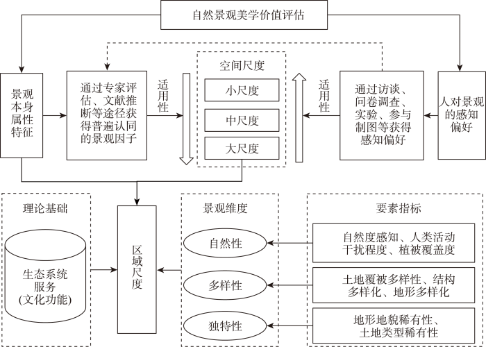
图2
区域尺度自然景观美学价值评估框架
Fig.2
A framework for evaluating the natural landscape aesthetic value at the regional scale
景观自然性选取的指标包括自然度感知、人类活动干扰程度、植被覆盖度。自然度感知的评价基础源自于人们对自然程度不同的土地覆被类型具有差异化的美感体验,如森林、水体往往能够产生更好的美感体验,而耕地、工矿用地则更差。参考Walz等[31]的研究及西藏的土地利用分类,确定了基于土地覆盖的感知自然度得分(表1)。人类活动干扰程度与景观自然性呈负相关关系,人类活动强度越高的地方往往带给人们越差的自然美感体验,本文借鉴Luo等[33]对西藏人类活动强度的研究成果,将人类活动干扰程度作为测度自然性的负向指标。植被覆盖度是反映区域生态环境状况的重要指标,植被覆盖率越高的地方景观自然性越强,具备更高的游憩吸引力[34]。本文采用归一化植被指数(NDVI)来表征地表植被的覆盖程度。
表1 基于土地覆盖的感知自然度得分
Tab.1
| 类型 | 得分 | 类型 | 得分 |
|---|---|---|---|
| 水田、旱地、城镇用地、农村居民点、其他建设用地 | 1 | 疏林地、低覆盖度草地、河渠、水库、坑塘、盐碱地 | 5 |
| 裸土地、裸岩石质地 | 2 | 灌木林、中覆盖草地 | 6 |
| 沙地、戈壁 | 3 | 有林地、高覆盖度草地、湖泊、永久性冰川雪地、滩涂、沼泽地 | 7 |
| 其他林地、滩地 | 4 |
景观独特性选取地形地貌稀有性和土地类型稀有性两个指标。稀有的地貌类型是促进景观感知和价值形成的重要信息来源,能够在区域尺度较好地表征景观独特性,根据Hou等[38]的研究,采用低频(高分)和高频(低分)地形地貌特征进行分类,根据面积份额和组间差异,采用50%、30%、10%、6%、3%、1%的分数阈值定义了7个稀有度级别,并依次赋值为1~7。土地覆被稀有性,罕见的土地覆盖类型容易形成高自然景观价值。在排除所有人工表面基础上,根据西藏各土地利用类型的比重,提取了低于3%的非典型土地覆盖类型,包括滩地、永久性冰川雪地、沼泽地、河渠、高寒荒漠。
2.3 指标权重与计算步骤
表2 西藏自然景观价值评估指标体系
Tab.2
| 景观维度 | 一级权重 | 指标项 | 二级权重 | 指标因子 | 指标属性 |
|---|---|---|---|---|---|
| 景观自然性 | 0.33 | 自然度感知 | 0.66 | 基于土地覆盖的自然度感知得分 | 正 |
| 人类活动干扰程度 | 0.17 | 人类活动强度指数 | 负 | ||
| 植被覆盖度 | 0.17 | 归一化植被指数(NDVI) | 正 | ||
| 景观多样性 | 0.33 | 土地覆被多样性 | 0.33 | 香农多样性指数 | 正 |
| 结构多样化 | 0.33 | 斑块边缘密度 | 正 | ||
| 地形多样化 | 0.33 | 地形起伏度 | 正 | ||
| 景观独特性 | 0.33 | 地形地貌稀有性 | 0.50 | 地形地貌分级得分 | 正 |
| 土地类型稀有性 | 0.50 | 低于3%的非典型土地覆盖类型 | 正 |
鉴于西藏面积广袤,本文选取1 km×1 km的栅格为基本评价单元,采用ArcGIS 10.7空间数据分析平台,评价得到全藏每个栅格单元的自然景观美学价值指数,在此基础上解析西藏自然景观美学价值的空间分异特征。计算过程分为4步:第一步,将空间分辨率不同的各类数据重采样为1 km×1 km的栅格,计算出各单指标的得分,并将结果归一化处理;第二步,根据指标项的权重,将各单指标加权求和分别得到景观自然性、多样性和独特性的得分,并绘制各维度指数图;第三步,采用景观自然性、多样性和独特性3个维度等权重求和,得到自然景观美学价值指数;第四步,根据自然断裂法将自然景观美学价值指数分为低、较低、中等、较高和高5个等级,并对其特征进行空间可视化分析。
其中,关于评价指标标准化。自然景观美学价值评价指标单位不一,不能直接进行比较与计算,需要将各指标进行归一化处理。评价指标分为正向指标和负向指标,其中,正向指标是指对自然景观美学价值具有积极促进作用的,其值越大,自然景观美学价值越高;负向指标则是对自然景观美学价值具有消极影响作用的指标,其值越大,自然景观美学价值越低。具体的标准化计算公式如下:
正向指标归一化公式
负向指标归一化公式
式中:
本文将采用综合指数法对西藏自然景观美学价值进行综合评价,计算自然景观美学价值指数:
式中:NLAV为自然景观美学价值指数,n为指标个数,
2.4 数据来源
土地利用数据来自中国科学院资源环境科学数据中心(
3 结果分析
3.1 景观自然性、多样性与独特性的格局特征
如图3所示,西藏景观自然性程度总体较高,低、较低、中等、较高和高等级的面积占比分别为22.8%、8.8%、25.9%、21.8%和20.7%。景观自然性空间上呈现出由西北向东南逐渐升高的趋势。藏东南热带雨林季雨林生态区的较高和高等级面积合计占比为84.9%,远高于其他生态区;藏东寒温性针叶林生态区、那曲高寒草甸草原生态区该比重也超过了50%,分别为58.7%和53.5%。而藏西地区的昆仑山高寒荒漠草原生态区、藏北高原高寒荒漠草原生态区和阿里山地温性干旱荒漠生态区较高和高等级面积合计占比仅30%左右,显著低于全藏平均值。主要原因是,在气候地形影响下,西北地区植被稀疏,虽然湖泊数量较多,但土地类型以裸土地、裸岩石质地、戈壁、低覆盖度草地为主,而东南地区植被茂密,土地类型以高覆盖度草地、灌木林、有林地为主。另外,虽然东南地区人类活动强度远高于西北地区,但人类活动占据的空间远少于广大的自然地区,因而对西藏景观自然性的影响很小。
图3
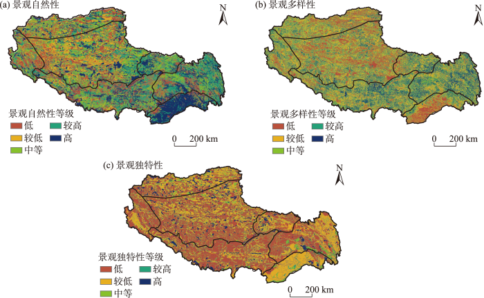
图3
西藏景观自然性、多样性与独特性评估结果及空间分布
Fig.3
Evaluation results and spatial distribution of landscape naturalness, diversity and uniqueness
西藏景观多样性空间分异特征显著。评价结果显示景观多样性低、较低、中等、较高和高等级的面积占比分别为16.2%、27.7%、23.9%、19.7%和12.5%。空间上呈现出“中间高、南北低”的分布格局。中间地带的藏东寒温性针叶林生态区、藏南山地高寒草甸草原生态区和那曲高寒草甸草原生态区景观多样性突出,较高和高等级面积合计占比分别为47.4%、41.0%和38.1%。该区域从喜马拉雅山脉延伸到横断山,地形起伏度大且垂直地带性强,土地类型多样化程度高,包括雪山、草地、森林、河流等。北部的昆仑山高寒荒漠草原生态区、藏北高原高寒荒漠草原生态区、阿里山地温性干旱荒漠生态区和南部的藏东南热带雨林季雨林生态区,较高和高等级面积合计占比均低于全藏平均值。北部地区主要是地势相对平坦,土地类型相对单一,以草地、沙地和戈壁等为主;南部地区虽然地形起伏度较高但土地利用为单一的林地。
西藏景观独特性高值区的面积较少。评价结果显示景观独特性低、较低、中等、较高和高等级的面积占比分别为47.6%、29.3%、9.2%、8.2%和5.7%。昆仑山高寒荒漠草原生态区、藏东寒温性针叶林生态区的独特性景观最为丰富,前者突出表现为拥有数量众多的高原湖泊湿地景观、冰川景观、高寒荒漠景观等独特景观,后者在突出的极大起伏中山、极大起伏高山等地形地貌特征下,形成了数量众多独特的雪山景观、冰川景观、峡谷景观。另外,识别出具有独特性景观还包括珠穆朗玛峰及周边的大起伏极高山地貌和雪山冰川、札达土林的高海拔台地地貌景观、羌塘高原的高原湖泊湿地景观以及广泛分布的中低海拔江河景观(图3)。
3.2 自然景观美学价值空间分异
西藏自然景观资源十分丰富,评价结果显示自然景观美学价值的高值区,即高、较高等级的面积占比分别为13.8%、21.4%。低值区,即低、较低等级的面积占比分别为12.2%、20.2%。空间上表现为东南高、西北低的总体分布格局(图4)。从生态区划来看,东南地区的藏东寒温性针叶林生态区、那曲高寒草甸草原生态区、藏东南热带雨林季雨林生态区,高值区面积比重均超过了45%,明显高于全藏平均值(35.2%)。而西北地区的藏北高原高寒荒漠草原生态区和阿里山地温性干旱荒漠生态区,高值区面积比重不到25%。
图4
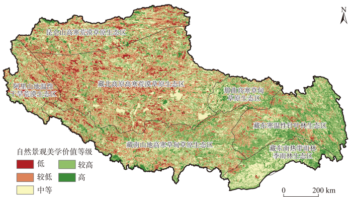
图4
西藏自然景观美学价值评估结果及空间分布
Fig.4
Evaluation results and spatial distribution of natural landscape aesthetic value in Tibet
自然景观美学价值高值区集中分布于3个区域。一是喜马拉雅山脉中段的珠峰区域,这里以著名的山地景观珠穆朗玛峰为中心的雪峰林立,广泛分布着冰斗冰川和悬冰川。另外,从高到低的垂直自然带谱系明显,在几十公里的范围内就分布着雪山、草原、盆地、灌木丛、湖泊、森林、河谷等立体式组合景观。二是藏东地区的喜马拉雅山脉东段、横断山脉和那曲高寒草甸草原区域,该区域地形起伏度大、河谷深切,植被覆盖率高、生物资源极其丰富,是全球景观差异性和生物多样性最丰富的地区之一,包括森林景观、江河流域景观、峡谷生态景观、高寒草甸景观和河谷景观等。拥有南迦巴瓦峰、雅鲁藏布大峡谷、密集的高原海洋性冰川、众多的温泉和瀑布、“西藏江南”美称的鲁朗林海森林等著名景观资源。三是藏北羌塘高原区域,最为凸显的是景观独特性。该区域地势平缓开阔,保存着较为原始的自然风貌,拥有世界上数量最多的高海拔湖泊,也有世界上最珍稀的野生动物群落和独特的动物区系。
自然景观美学价值中等区广泛分布于全藏,主要位于高值区与低值区之间的过渡地带。在各生态区中,中等级面积占比在藏东南热带雨林季雨林生态区中最为突出,为39.4%,主要的原因是该区域土地类型虽然是以森林为主导,基于土地覆盖的感知自然度得分较高,但土地类型多样化、稀有性以及结构多样化的得分较低。其他生态区中的中等级面积占比大体相当,比重均在26%~35%之间。土地覆盖多为疏林地、低覆盖度草地、滩地、沙地、戈壁,亦有部分为灌木林、中覆盖草地等感知自然度得分较高的土地类型,但因地形多样化、土地覆被多样性和景观类型的稀有性评分较低,导致自然景观美学价值处于中等水平。
自然景观美学价值低值区主要分布于西部地区的藏北高原高寒荒漠草原生态区、阿里山地温性干旱荒漠生态区,二者低值区面积占比分别为41.7%、42.9%,远高于全藏平均值(32.4%)。该区域植被类型十分简单,以高寒荒漠植被和灌丛草原为主,归一化植被指数极低;土地类型多为裸土地、裸岩石质地、沙地、戈壁和低覆盖度草地,土地覆被多样性总体较低;地势相对高度不大,多为低山丘陵;地表径流匮乏,河网稀疏,多季节性河流。另外,低值区也广泛分散分布于中部的东部地区:一是人类活动强度水平较低的农牧地区,包括以点状分布的乡村聚落,以及受农牧民影响较大的面状分布的耕地和牧草地;二是人类活动强度水平较高的城市、城镇及其周边地区,以及干线公路及其两侧人工建筑较多的地方,景观自然性程度较低;三是广泛分布于高值区和中等级区之间,主要土地类型为感知自然度得分较低的裸土地、裸岩石质地、沙地等。
3.3 国家公园群备选区的自然景观美学价值比较
建设第三极国家公园群是西藏落实主体功能区大战略、走绿色发展之路的科学抉择。在第二次青藏高原综合科学考察研究初始阶段,樊杰等[39]便提出地球第三极国家公园群概念,将国家公园作为青藏高原地区大尺度优化国土空间开发保护格局、协调青藏高原人地耦合系统的新型地域功能。根据国家第二次青藏科考方案,共遴选了13个国家公园备选区,组成全球分布集中、覆盖面大、生态特色鲜明、游憩观光科普研究价值突出的国家公园群。其中,西藏共有4个备选区,分别是冈仁波齐、雅鲁藏布大峡谷、珠穆朗玛和羌塘。评估结果显示,4个国家公园备选区的自然景观美学价值高值区面积比重为41.2%,显著高于全藏平均水平,表明国家公园备选区在自然景观资源方面有较好的优越度(图5)。
图5
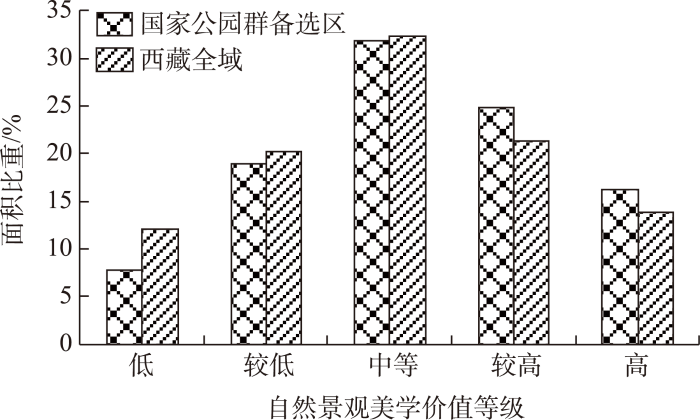
图5
国家公园备选区与西藏全域景观美学价值评价等级比较
Fig.5
Comparison of natural landscape aesthetic values of potential national parks and Tibet as a whole
分国家公园来看,按照自然景观资源优越度等级序列,第一为雅鲁藏布大峡谷国家公园备选地,该区自然景观美学价值极为突出,高值区面积占比为61.9%,景观自然性、多样性与独特性评价结果均为高值,拥有世界级的景观资源,以世界最深最长的峡谷森林景观和海洋性冰川群为核心,高价值景观包括高山峡谷、垂直地带生态系统景观、雪山冰川。第二为珠穆朗玛国家公园备选地,该区自然景观美学价值高值区面积占比为37.8%,以世界第一高峰和7000余米完整的垂直地带性景观为核心,高价值景观包括雪山冰川、高山湖泊、高原河流、高原草甸景观。第三包括冈仁波齐国家公园备选地和羌塘国家公园备选地,二者景观美学价值相对较低,高值区面积占比均为30%左右。冈仁波齐国家公园备选地中的神山圣湖片区是聚雪山、湖泊、湿地、草原、荒漠为一体的典型高原自然景观,札达土林片区自然性以及多样性水平较低,但景观独特性突出,这里的水平岩层地貌经洪水冲刷、风化剥蚀而形成的独特地貌,形成了全球独一无二的土林规模和形态,具有大尺度景观的宏伟气势。羌塘国家公园备选地虽景观自然性与独特性较高,但景观多样性不足,拥有全藏第一大湖泊核心的高寒湿地生态景观,以及以普若岗日冰原为核心的世界上中低纬度最大的冰川群景观(图6)。
图6
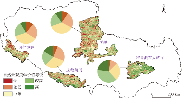
图6
西藏国家公园备选区自然景观美学价值评估结果
Fig.6
Evaluation result of natural landscape aesthetic value of potential national parks in Tibet
4 讨论与启示
不同维度和各要素对西藏自然景观美学价值的影响程度差异明显。根据各维度和各要素自身差异程度和贡献分析,维度层面影响程度从高到低分别是景观多样性、景观自然性、景观独特性。关于景观多样性,西藏自然地理条件特殊,地形上就形成了青藏高原边缘地带的高山峡谷与高原中部地区的高山平原之间巨大的地形差异性;与此同时,伴随着地形和气候作用,西藏东南地区和西北地区的土地覆被多样性也产生了巨大的差异,西北地区为高寒荒漠草原或干旱荒漠区,地势平坦,土地覆被单一,而东南地区海拔高度差极大,垂直地带性突出,土地覆被多样性极为丰富。其次是景观自然性,其中自然感知度与植被覆盖度的作用强度较大,特别是在不同生态区之间的差异性极为显著;但人类活动干扰程度作用较小,这主要因为西藏人类活动规模极低,2020年全藏建设用地比重仅为0.05%左右[40],远低于其他省区。最后,景观独特性存在尺度上的差异,大尺度空间层面景观类型的稀有性因地形地貌而影响程度高,小尺度空间范围内的土地类型稀有性面积较小,而且与自然性感知度的评价结果部分重叠,因而表现出的影响程度不高。
区域层面的自然景观美学价值评估是探索大尺度的国家公园景观空间组织规则的重要基础。青藏高原大尺度景观价值突出,探索国家公园体系建设则是实现区域绿色资本增值与生态保护的重要路径[39]。可以将景观美学价值评估及其在利用保护、规划、管理等方面的运用作为重要前提。全域的景观价值评估可为国家公园边界划定提供依据,确保重要的高价值自然景观资源能够纳入国家公园体系,而且实现了不同国家公园整体层面的价值比较,确定国家公园资源优越度等级序列,根据不同等级规模、区位等因素确定各国家公园的景观资源利用模式。单个国家公园层面的景观评价可为具体的开发利用空间选择、生态旅游路线设计、游憩设施布局等决策提供帮助,一方面保障公园景观的连接性与完整化等为游客提供丰富的景观价值服务,另一方面有助于选准具体的景观点(路线)实现通过小部分的开发利用,达到区域生态保护和经济发展的双赢。
开展自然景观美学价值评估,并与生态脆弱性进行空间权衡,是在区域尺度解决旅游发展与生态保护的有效途径。目前,基于自然的旅游正在全球范围内快速增长[41],特别是新冠疫情之后,可以预见,进入西藏的旅游人口将大规模增加,对地方脆弱的生态环境和自然景观资源的保护会产生极大的风险。因此,亟需在全域尺度实施有效的策略,加强生态和自然景观受损风险管控。旅游是否对生态产生负面影响实质上取决于旅游压力与生态脆弱性之间的耦合。生态脆弱性越强的地方越容易受到人类活动不可逆的干扰,而旅游压力往往又与自然景观价值高度相关,研究表明,自然景观价值越高的地方往往越容易吸引更多的游客前往[42]。因此,可持续的旅游空间策略必须要同时考虑自然景观价值和生态脆弱性。遗憾的是,在大尺度空间上,已有研究更多的只关注了其中一个维度,倾向在高自然景观价值的地方开发布局旅游设施或是在生态脆弱性高的地区实施严格保护措施[43]。因此,本文提出可尝试按照自然景观美学价值的高低和生态脆弱性的强弱,划分为4种类型区,并提出管理方向:第一是显著冲突倾向型,即自然景观价值和生态脆弱性都高的地方,需要做充分的生态风险评估,谨慎发展旅游业;第二是生态优先型,生态脆弱性高而景观价值低,适宜严格的生态保护;第三是景观优先型,这些地方景观价值较高而生态脆弱性较低,适宜作为未来重点发展自然旅游的备选地;第四是无冲突倾向型,即自然景观价值和生态脆弱性都较低的地方,适宜建设住宿、道路交通等配套自然旅游的基础设施。
5 结论与展望
西藏自然景观资源极为丰富,是青藏高原国家公园群建设的重点区域。本文基于自然景观美学价值的内涵,从自然性、多样性和独特性3个维度构建了自然景观美学价值评估指标体系,对西藏进行了区域层面的综合评估。评价结果显示,景观自然性、多样性与独特性的空间分异特征显著,这是自然景观美学价值区域差异性的重要基础。西藏自然景观美学价值处于低、较低、中等、较高和高等级的面积占比分别为12.2%、20.2%、32.4%、21.4%和13.8%,空间上呈现出东南高、西北低的总体分布格局,多样性、自然性、独特性影响程度逐次降低。高值区集中分布于藏东的喜马拉雅山脉东段和横断山脉、喜马拉雅山脉中段的珠峰地区、藏北羌塘国家级自然保护区3片区域。国家公园备选区中,自然景观美学价值从高到低分别是雅鲁藏布大峡谷、珠穆朗玛、冈仁波齐和羌塘。从区域层面进行的自然景观美学价值评价结果,对西藏整体的旅游发展与生态保护的空间权衡、国家公园层面的景观利用与管理等问题的决策支持,均能提供一定的科学依据。
本文还存在一定的局限性,需要未来进一步探索。首先,本文从自然性、多样性和独特性开展评估,但景观美学价值的内涵丰富,还有一些维度并未涉及,如声景观、嗅觉景观等,有待于深入研究。其次,因数据可获得性等原因,一些指标相对简单,代表性不够,空间分辨率不同的各类数据在转换过程中也会产生误差。未来需要融合高精度遥感数据、地形数据、地面调查等多元数据,采用新技术、新方法为评估提供新路径。再次,西藏的气候类型特殊,季节性征十分明显,与此同时,旅游活动存在淡旺季的显著差异,因此,将季节性纳入评估中对揭示该地区的景观特征以及实际决策支持都具有重要意义。最后,大尺度区域尺度的评价应该与小尺度的典型区评估进行有机融合。区域评价结果为高景观价值区(典型区)的选择提供指引,在典型区则可开展视域分析、个体偏好分析、高精度数据分析等深入研究,一方面可验证区域尺度的评价结果,另一方面有益于改进和提升区域尺度的评价方法。
致谢
真诚感谢匿名评审专家在论文评审中所付出的时间和精力,专家对本文的结构完整性、结论凝练性以及政策必要性等方面提出丰富建议,使本文获益匪浅。
参考文献
Landscape and well-being: A scoping study on the health-promoting impact of outdoor environments
[J].
DOI:10.1007/s00038-009-0069-z
PMID:19768384
[本文引用: 1]

The present literature review conceptualises landscape as a health resource that promotes physical, mental, and social well-being. Different health-promoting landscape characteristics are discussed.This article is based on a scoping study which represents a special kind of qualitative literature review. Over 120 studies have been reviewed in a five-step-procedure, resulting in a heuristic device.A set of meaningful pathways that link landscape and health have been identified. Landscapes have the potential to promote mental well-being through attention restoration, stress reduction, and the evocation of positive emotions; physical well-being through the promotion of physical activity in daily life as well as leisure time and through walkable environments; and social well-being through social integration, social engagement and participation, and through social support and security.This scoping study allows us to systematically describe the potential of landscape as a resource for physical, mental and social well-being. A heuristic framework is presented that can be applied in future studies, facilitating systematic and focused research approaches and informing practical public health interventions.
Assessing, mapping, and quantifying cultural ecosystem services at community level
[J].DOI:10.1016/j.landusepol.2012.12.013 URL [本文引用: 1]
Landscape services as a bridge between landscape ecology and sustainable development
[J].DOI:10.1007/s10980-008-9314-8 URL [本文引用: 1]
地球第三极国家公园群的地域功能与可行性
[J].
Territorial function and feasibility of the Earth's Third Pole National Park cluster
国家公园群建设的层级结构识别: 以青藏高原国家公园群为例
[J].
DOI:10.18306/dlkxjz.2022.06.003
[本文引用: 1]
层级结构识别是推进国家公园群建设的基础工作。然而,已有研究较少关注国家公园群层级结构定量识别。论文结合理论分析与多准则分析方法,提出国家公园群建设层级结构识别的UBAN框架(uniqueness, biodiversity, aesthetic value, naturalness),并以青藏高原国家公园群为例进行实证分析。研究表明,青藏高原国家公园群内部单体之间存在较大差异,长江源的相对重要性最高,海西盐湖最低。层级划分方案对比分析显示,采用“四分法”有助于推进分层管理。据此方案,青藏高原国家公园群的一级单体包括长江源等5个,二级单体包括帕米尔等6个,三级单体包括普达措等4个,四级单体包括贡嘎山等6个,不同层级在青藏高原国家公园群建设中的优先顺序、建设重点和策略不同。研究强调了国家公园群层级识别的必要性,提出并验证了UBAN框架在国家公园群层级结构识别中的可行性,有助于推动国家公园群建设管理策略制定和目标实现。
Hierarchical structure identification of national park groups: Taking the Qinghai-Tibet Plateau national park group as an example
DOI:10.18306/dlkxjz.2022.06.003
[本文引用: 1]
Hierarchical structure identification is important for the construction of national park groups. However, existing studies have paid little attention to the method for the identification of hierarchical structure of national park groups. This study proposed the UBAN framework (Uniqueness, Biodiversity, Aesthetic value, Naturalness) for the identification of park hierarchy in national park groups through theoretical analysis and multi-criteria analysis methods, and applied the framework to the Qinghai-Tibet Plateau National Park Group for testing its feasibility and validation. The results show that the UBAN framework is feasible and easy to operationalize in identifying hierarchical structure of the national park group. Among the 21 national parks, the Source of the Yangtze River has the highest relative importance, followed by Mount Everest and Giant Pandas. The large difference in relative importance within the national park group is attributed to differences in various dimensions. When the four-level structure is adopted, the overall difference is mainly caused by the differences between the levels rather than the differences within each level, suggesting that the four-level structure is suitable for national park group management based on the characteristics of each level. In the four-level structure, the first level includes the Source of the Yangtze River, Mount Everest, Giant Pandas, Selincuo-Puruogangri, and the Source of the Yellow River. Parks at this level have the highest ecosystem uniqueness, biodiversity, aesthetic value, and naturalness, and plays a central role in the construction of the Qinghai-Tibet Plateau National Park Group. The second-level includes Pamirs, Brahmaputra Grand Canyon, Sacred Mountain and Holy Lake, Qilian Mountains, the Source of the Lancang River, and Kunlun Mountains-Hoh Xil. Parks at this level have high ecosystem uniqueness, biodiversity, aesthetic value, and naturalness, and should be further optimized in the construction of the Qinghai-Tibet Plateau National Park Group. The third-level includes Pudacuo, Daocheng Yading, Ruoergai, and Zanda Earth Forest. Parks at this level have moderate ecosystem uniqueness and biodiversity, and should be characteristically developed in the construction of the Qinghai-Tibet Plateau National Park Group. The fourth-level includes Yadan, Gongga Mountain, West Tianshan, Dulong River-Three Parallel Rivers, Zari Mountain, and Haixi Salt Lake. Parks at this level have lower ecosystem uniqueness, biodiversity, aesthetic value, and naturalness, and should be given significant supports in the construction of the Qinghai-Tibet Plateau National Park Group. This study contributes to the national park group structure theory and offers implications for the construction practices of national park groups.
Landscape and the philosophy of aesthetics: Is landscape quality inherent in the landscape or in the eye of the beholder?
[J].DOI:10.1016/S0169-2046(99)00019-5 URL [本文引用: 2]
生态系统服务视角下的景观美学研究进展
[J].
Research progress of landscape aesthetics from the perspective of ecosystem service
Assessing the visual quality of rural landscapes
[J].DOI:10.1016/j.landurbplan.2003.10.029 URL [本文引用: 1]
Evaluation for landscape aesthetic value of the natural world heritage site
[J].The landscape aesthetic value (LAV) is one essential component of outstanding universal value (OUV) for a Natural World Heritage Site (NWHS). In the identification of LAV, there is the subjectivity of methodology suggested by IUCN in the operation manual, and the expert-led evaluation is insufficient for reflecting all observers' opinions. This study focuses on establishing a universal system combining the subjectivity and objectivity, the experts' and the public's opinions to evaluate the LAV of an NWHS. We used the NWHS criteria, the ecological environment, and the viewing experience as established indicators; nine metrics were applied as corresponding layers respectively to map and give a final spatial evaluation based on the ArcGIS overlay analysis with their comprehensive weights from 3 groups of decision makers. In order to verify the rationality of our model, the LAV of a case study in Bayanbulak of NWHS Xinjiang Tianshan has been evaluated. It is demonstrated that central region of Bayanbulak with unique landscape that taking rivers, lakes, and swamps as base interlacing with wetland meadows has particularly high LAV; it basically shows a concentric circle-like distribution feature that LAV decreases from inside to outside and is consistent with practical protection status. This study responds to the UNESCO's request to monitor and evaluate the OUV of the NWHS; we believe results can provide a useful reference for the planning and decision-making of relevant scenic spots.
Whither scenic beauty? Visual landscape quality assessment in the 21st century
[J].DOI:10.1016/S0169-2046(01)00141-4 URL [本文引用: 1]
Linking ecosystem services with cultural landscape research
[J].
DOI:10.14512/gaia.19.4.9
URL
[本文引用: 1]
The concept of ecosystem services facilitates the valuation of the multiple services from ecosystems and landscapes, the identification of trade-offs between different land use scenarios, and also informs decision making in land use planning. Unfortunately, cultural services have been\n mostly neglected within the ecosystem services framework. This could result in trade-off assessments which are biased and mislead ecosystem management and landscape planning. However, cultural landscape research approaches have proven valuable in the assessment of different nonmaterial landscape\n values and cultural services. In this paper, we compare the objectives, approaches, and methodologies adopted by ecosystem services research and cultural landscape research through a bibliographic research. Both research communities investigate the human dimension of ecosystems and landscapes\n and, hence, study the same object. A closer link between the two research communities would enrich and possibly sharpen both approaches. In particular, landscape research on cultural services such as aesthetics or cultural heritage could provide valuable results and methods for a comprehensive\n assessment of ecosystem services.
国际视觉景观研究评述
[J].
DOI:10.11820/dlkxjz.2013.06.015
[本文引用: 1]
视觉景观研究在旅游景区建设、城乡规划与管理等领域具有广泛的应用前景。本文对近10 年国外相关研究进行回顾, 将其分为视觉景观质量评价、视觉影响评价、视觉景观偏好3 个方面, 阐述三者的基本含义、理论来源, 重点介绍每个领域的研究主题、方法与技术, 同时分析其中存在的优缺点及借鉴意义。在景观质量评价方面, 研究重点仍在景观元素及特征对景观质量的影响, 心理物理学方法居主导地位, 呈现专家方法与之结合的趋势。在视觉影响评价方面, 城乡建筑及能源设施产生的视觉影响为近期学者关注的焦点, GIS和3D可视化技术拓展了质量评价和影响评价的时空尺度, 提高了精确性。在视觉景观偏好方面, 学者从欣赏的主客体即人与景观两个角度进行了研究, 深入挖掘人的自然、文化属性及景观特征对景观偏好的影响, 并证实对景观的偏爱能够促进景观保护与土地合理利用。最后对近期国外研究状况进行总结, 提出了未来研究的方向及对国内研究的有益启示。
A review on visual landscape study in foreign countries
DOI:10.11820/dlkxjz.2013.06.015
[本文引用: 1]
Visual landscape study has a wide application prospect in the construction of scenic spots as well as urban and rural planning and management. Related foreign researches in the last decade were reviewed and divided into three parts in this paper: visual landscape quality assessment, visual impact assessment, and visual landscape preference. The basic implications and theoretical sources were introduced. This paper mainly concerns the topics, methods and techniques of each field. At the same time, advantages, disadvantages as well as relevant significance were analyzed. First, in landscape quality assessment, the research emphasis was the contribution of landscape elements and features to landscape quality. Psychophysical approaches were commonly used in this area, but there was an apparent tendency toward combination of the expert-based approach and the psychophysical approach. Secondly, visual impact caused by urban and rural buildings and renewable-energy facilities received much attention. GIS and 3D visualization techniques enlarged temporal-spatial scales and improved the precision of quality and impact assessment. Thirdly, scholars investigated visual landscape preference from two perspectives: human and landscape which was respectively subjective and objective part of appreciation. Not only human natural and cultural attributes but also landscape features were deeply explored to demonstrate the influence in landscape preference. It was confirmed that landscape preference could promote landscape preservation and rational land use. In conclusion, the progresses of the studies on visual landscape were summarized as follows: visual landscape study was more instructive in landscape planning and construction, because the subjective and objective methods were gradually integrated and the techniques were diversified; study areas were unbalanced and study objects were a little dull, so more relevant researches should be made in the developing countries and scholars should pay much attention to visual impact of a large variety of landscape types; there was a need for comprehensive perspectives as the number of interdisciplinary studies was increasing; the foreign researches had some enlightenment for the domestic ones.
Mapping and assessment of landscape aesthetic quality in Lithuania
[J].
Empirical PPGIS/PGIS mapping of ecosystem services: A review and evaluation
[J].DOI:10.1016/j.ecoser.2014.10.007 URL [本文引用: 1]
Trends in the use of landscape spatial metrics as landscape indicators: A review
[J].DOI:10.1016/j.ecolind.2012.07.018 URL [本文引用: 1]
Perceived land use patterns and landscape values
[J].DOI:10.1007/BF02275264 URL [本文引用: 1]
"Maps have an air of authority": Potential benefits and challenges of ecosystem service maps at different levels of decision making
[J].DOI:10.1016/j.ecoser.2012.11.003 URL [本文引用: 1]
The cultural values model: An integrated approach to values in landscapes
[J].DOI:10.1016/j.landurbplan.2007.07.003 URL [本文引用: 1]
国外国家公园景观评价与保护利用研究进展及对中国的启示
[J].
DOI:10.18402/resci.2022.07.16
[本文引用: 2]
国家公园作为兼具完整性、原真性和景观美学的地域综合体,景观价值的有效发挥是实现其全民共享和公益性的重要载体。建立景观多维价值评价及其保护利用的综合研究方法,对国家公园景观功能的发挥具有重要意义。本文通过对国外国家公园景观评价和保护利用领域的文献分析,进一步结合自然保护地景观利用的相关成果,从评价方法、开发利用、管理保护等方面对近30年来国家公园景观研究进行综合评述。研究发现:①国外国家公园研究视角由单一的景观美学,转向多功能景观利用与保护的耦合协同,围绕“识别-评价-保护-利用”的思路向外延展;②国外国家公园景观评价相关研究主要围绕景观评价方法和可操作性框架展开,探索不同尺度的多类型景观价值科学评价理论与方法,评价维度日趋完善;③国家公园景观的保护和利用主要考虑与游憩活动、土地利用变化、社区发展及景观保护之间的关系,通过景观利用的经济社会价值衔接来促进可持续发展。针对中国国家公园景观资源利用,本文构建了“景观识别-景观评价-景观保护与利用”的景观综合评价利用框架,希冀为中国国家公园景观评价与保护利用提供借鉴与启示。
Research progress of international landscape evaluation, protection, and utilization of national parks and implications to China
DOI:10.18402/resci.2022.07.16
[本文引用: 2]
As a regional complex system with integrity, authenticity, and landscape aesthetics, the effective realization of the value of landscape resources is an important carrier to implement the public sharing and public welfare functions of national parks. It is necessary to establish a comprehensive research method of landscape multi-dimensional value evaluation and its utilization effects. In this study, through the analysis of relevant literature and further combined with the results of research of landscape utilization of national parks, we conducted a comprehensive review on the landscape research of national parks in the past three decades from the aspects of evaluation methods, development and utilization, management and protection, among others. We found that the international research on landscape evaluation of national parks mainly focuses on the method and framework of landscape evaluation, and the evaluation dimension is becoming increasingly more refined. The protection and utilization of national park landscape should fully consider the relationship between recreational activities, land use change, community development, and landscape protection, and promote sustainable development through the joint implementation of economic and social values of landscape use. For the utilization of landscape resources in national parks in China, a landscape comprehensive evaluation and utilization framework of “identification-evaluation-management” is constructed, in order to provide some reference and implications for the national park landscape evaluation, protection, and utilization in the country.
青藏高原市域综合交通优势度评价及空间特征: 以林芝市为例
[J].
DOI:10.18306/dlkxjz.2021.08.007
[本文引用: 1]
青藏高原的特殊性长期约束着交通设施的建设与功能,科学评价其交通状况具有重要意义。论文以林芝市为例,考虑自然特征、多种交通方式及交通稳定性,构建综合交通优势度评价体系进行实证探讨。研究发现:① 综合交通优势度以巴宜区、米林县、工布江达县得分较高,其中中心乡镇尤其明显,分别在内部交通功能、对外交通功能、区位优势度方面具有优势,察隅县、墨脱县综合交通优势度及各分项得分均较低,G318、林拉公路、米林机场等重点交通设施影响突出;② 林芝市综合交通优势度的县域差距及空间极化效应趋于增强,但中心—外围结构的空间完整性被地形等因素隔离破坏,边境地区成为林芝市综合交通优势度最为薄弱的环节;③ 综合交通优势度与人口分布具有一定匹配性,多数乡镇二者之间呈协调水平,但以初、中级协调为主,边境和自然条件约束明显的地区尚需考虑优化。根据林芝市特点,改进后的综合交通优势度评价更好地揭示了区域交通薄弱地区,对青藏高原或其他类似特殊地域单元的交通设施评价具有参考意义。
Comprehensive traffic advantage degree and its spatial characteristics at the prefecture level on the Qinghai-Tibet Plateau: A case study of Linzhi City
DOI:10.18306/dlkxjz.2021.08.007
[本文引用: 1]
The unique natural environment of the Qinghai-Tibet Plateau has restricted the construction and function of its transportation infrastructure. In order to evaluate the traffic facilities on the Qinghai-Tibet Plateau, taking Linzhi City, a typical area of southeastern Tibet with high altitude and uneven terrain, as an example and considering the natural characteristics, various transport modes, transport stability, and location advantage, this study established an evaluation system of comprehensive traffic advantage degree to empirically examine the situation in 2015 and 2020. The results show that: 1) Bayi District, Milin County, and Gongbujiangda County, especially their central towns, have much higher scores in internal traffic function, external traffic function, and location advantage degree, while the values of traffic advantage and many of its indicators in Chayu County and Motuo County are low, and the impact of some key transportation infrastructures such as the G318 Highway (national highway), Linzhi-Lhasa Highway, and Milin Airport is prominent. 2) The results of spatial difference analysis show that the comprehensive traffic advantage degree of Linzhi City is unbalanced, and the county-level gap and spatial polarization effect tend to increase. However, the core-periphery spatial structure is fragmented and interrupted by terrain factors of extreme difference in altitude, and the border area of Linzhi City becomes the weakest part with regard to the comprehensive traffic advantage degree. 3) There is a certain degree of matching between the comprehensive traffic advantage degree and the population distribution as shown by the linear trend line and coupling coordination relationship. Bayi District, Milin Town, and Gongbujiangda Town have reached the high-quality coordination level. However, most of the towns are at the preliminary or intermediate coordination level, while in the border area and areas with severe natural constraints, the coordination degree urgently needs to be optimized. Methodologically, by superimposing regional natural attributes, expanding the evaluation dimension of traffic advantage degree, and integrating various modes of transportation, the comprehensive traffic advantage evaluation conforms to the actual situation of the study area. Regional transport evaluation that incorporates the consideration of natural environment characteristics has practical significance for supporting territorial planning and transportation infrastructure evaluation and management, especially for regions such as the Qinghai-Tibet Plateau.
Key concepts in a framework for analysing visual landscape character
[J].DOI:10.1080/01426390600783269 URL [本文引用: 1]
Identifying indicators of aesthetics in the Great Barrier Reef for the purposes of management
[J].
Integrating socio-cultural perspectives into ecosystem service valuation: A review of concepts and methods
[J].DOI:10.1016/j.ecolecon.2015.03.007 URL [本文引用: 1]
An integrated method for the mapping of landscape preferences at the regional scale
[J].
Indicators of perceived naturalness as drivers of landscape preference
[J].
DOI:10.1016/j.jenvman.2007.10.013
PMID:18280633
[本文引用: 1]
The concept of naturalness is one of the more studied concepts in landscape preference research and describes how close a landscape is to a perceived natural state. In this study we explored the relationship between landscape preference and three landscape indicators of naturalness (level of succession, number of woodland patches and shape index of edges). We used computer-generated visualisations of a hypothetical landscape containing pasture and broadleaved woodland. In the landscape simulations we altered the values of the naturalness indicators between the levels of low, medium and high, creating 27 different visualisations. The survey was distributed as an on-line survey in seven different languages and obtained 703 respondents. The study showed a strong relationship with preference for both the level of succession and number of woodland patches, and a weaker relationship with shape index of edges. The two demographic factors which were shown to contribute most to the formation of preference were gender and having a landscape related profession. The results suggest that the selected indicators are more important drivers of preference than demographic factors.
Identifying and mapping the tourists' perception of cultural ecosystem services: A case study from an Alpine region
[J].DOI:10.1016/j.landusepol.2016.05.004 URL [本文引用: 1]
Important places in landscape-investigating the determinants of perceived landscape value in the suburban area of Wroclaw, Poland
[J].
Assessing the aesthetic quality of landscapes in Germany
[J].DOI:10.1016/j.ecoser.2018.02.015 URL [本文引用: 3]
Indicators of hemeroby for the monitoring of landscapes in Germany
[J].DOI:10.1016/j.jnc.2014.01.007 URL [本文引用: 2]
The preference and actual use of different types of rural recreation areas by urban dwellers: The Hamburg case study
[J].
Increased human pressures on the alpine ecosystem along the Qinghai-Tibet Railway
[J].
青藏高原国家公园群游憩功能的自然基础与实现路径
[J].
The natural foundation and realization path of the recreation function of the Qinghai-Tibet Plateau national park group
Relationships between visual landscape preferences and map-based indicators of landscape structure
[J].DOI:10.1016/j.landurbplan.2005.12.006 URL [本文引用: 1]
Critical review of landscape-based surrogate measures of plant diversity
[J].DOI:10.1080/01426397.2020.1795095 URL [本文引用: 1]
A terrain ruggedness index that quantifies topographic heterogeneity
[J].
Mapping and assessment of recreation services in Qinghai-Tibet Plateau
[J].
建设第三极国家公园群是西藏落实主体功能区大战略、走绿色发展之路的科学抉择
[J].
Third pole national park group construction is scientific choice for implementing strategy of major function zoning and green development in Tibet, China
西藏自治区第三次全国国土调查主要数据公报
[EB/OL]. 2021-12-24 [2022-12-06]. http://zrzyt.xizang.gov.cn/dt/gsgg/202112/t20211224_276279.html.
Bulletin of the main data of the third national land survey of the Tibet Autonomous Region
2021-12-24 [2022-12-06]. http://zrzyt.xizang.gov.cn/dt/gsgg/202112/t20211224_276279.html.]
Evidence for a fundamental and pervasive shift away from nature-based recreation
[J].
DOI:10.1073/pnas.0709893105
PMID:18250312
[本文引用: 1]
After 50 years of steady increase, per capita visits to U.S. National Parks have declined since 1987. To evaluate whether we are seeing a fundamental shift away from people's interest in nature, we tested for similar longitudinal declines in 16 time series representing four classes of nature participation variables: (i) visitation to various types of public lands in the U.S. and National Parks in Japan and Spain, (ii) number of various types of U.S. game licenses issued, (iii) indicators of time spent camping, and (iv) indicators of time spent backpacking or hiking. The four variables with the greatest per capita participation were visits to Japanese National Parks, U.S. State Parks, U.S. National Parks, and U.S. National Forests, with an average individual participating 0.74-2.75 times per year. All four time series are in downtrends, with linear regressions showing ongoing losses of -1.0% to -3.1% per year. The longest and most complete time series tested suggest that typical declines in per capita nature recreation began between 1981 and 1991, are proceeding at rates of -1.0% to -1.3% per year, and total to date -18% to -25%. Spearman correlation analyses were performed on untransformed time series and on transformed percentage year-to-year changes. Results showed very highly significant correlations between many of the highest per capita participation variables in both untransformed and in difference models, further corroborating the general downtrend in nature recreation. In conclusion, all major lines of evidence point to an ongoing and fundamental shift away from nature-based recreation.
Spatial tradeoff between biodiversity and nature-based tourism: Considering mobile phone-driven visitation pattern
[J].
The role of seasonality in assessments of conflict tendency between tourism development and ecological preservation in protected areas: The case of protected areas in China
[J].
