

近年来,随着中国城镇社会经济的快速发展,人们对于居住地的环境品质要求越来越高,对城市公共服务设施的建设愈加关注。其中某些公共服务设施因其正外部性而受到附近居民的欢迎,如公园绿地、优质学校,而某些具有负外部性的设施,如垃圾处理场、殡仪馆等,则受到附近居民的排斥,产生了“邻避效应”(not in my backyard,NIMBY)[1]。20世纪70年代,邻避效应开始受到西方学术界关注。相关研究证实了化工厂、废弃物处理设施、核电站等邻避设施的规划选址会遭到周边居民的反对,进而引发环境正义运动。解决邻避冲突的核心理念是正视公民在使用环境资源的权利和保护环境的义务之间的公平分配,从而实现环境正义[2]。在西方国家,邻避设施主要分布在贫穷和少数族裔社区,呈现分配不正义的现象[3]。低收入社区和有色人种往往承担着污染工业、垃圾焚烧、废水处理等环境风险[4]。此外,邻避设施还会导致周边住宅贬值,如Agee等[5]发现影响火葬场周边住宅价格的因素是距火葬场的方向和距离;Currie等[6]发现工厂导致0.5英里(1英里=1.609 km)以内的房屋价格降低11%。此外,发电厂[7]、高速公路[8]、垃圾中转站[9]等邻避设施都会对周边住宅价格产生负面影响。
综上,国内外对邻避设施进行了较为深入的研究,但仍存在一些值得探讨的问题,主要表现在:一是鲜有研究系统地分析城市邻避设施的空间分布特征;二是在分析邻避设施与周边地区房价的关系方面,一般采用特征价格法,忽略了地理空间要素的影响。为此,本文以广州市主城区为例,通过克里金插值法分析了邻避设施的空间分布特征,构建地理加权回归(geographically weighted regression,GWR)模型分析邻避设施与周边住宅价格的关系。结合环境正义理论,研究邻避设施分布的社会空间影响,期望为邻避设施的科学规划提供理论指导。
1 概念界定与理论基础
1.1 邻避设施的概念及特征
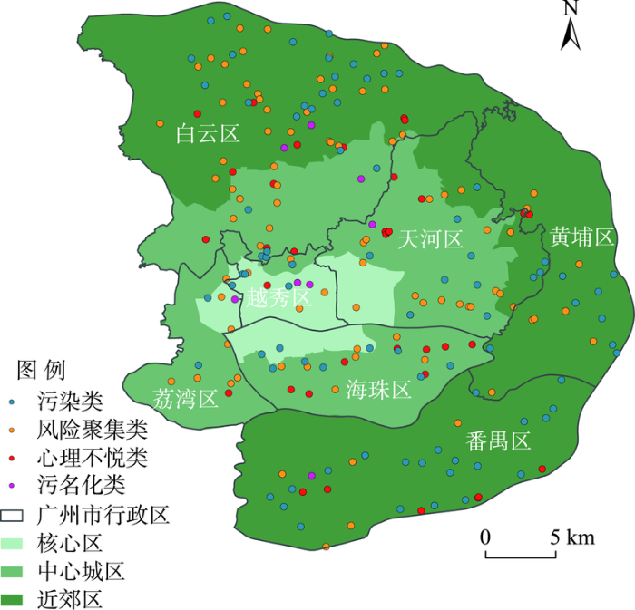
邻避设施的概念最早由美国学者O'Hare[14]提出,指给社会带来整体性利益却给邻近居民带来不良影响的设施。Dear[15]将对居民安全、住宅价值和社区舒适性可能造成威胁的设施定义为邻避设施。李伊祺等[16]认为邻避设施是“对身体健康、个人资产等带来负面影响而使居民产生厌恶心理的设施”。目前国内外通常将产生的利益为全社会共享,但产生的负外部效应却由附近居民承担的设施定义为邻避设施。邻避设施具有以下几个特征:第一,邻避设施是保证社会正常运转的基础性物质条件;第二,邻避设施具有明显或潜在的风险性,例如水污染、空气污染、噪音污染等;第三,邻避设施的布局往往会受到周边居民的反对。根据邻避设施的不同特征,可分为污染类(如市区高架、垃圾处理设施、飞机场等)、风险聚集类(如变电站、加油站、发电厂、化工厂等)、心理不悦类(如火葬场、殡仪馆、墓地等)和污名化类(如戒毒中心、精神病院、监狱等)[17]。
1.2 理论基础
近年来,环境正义作为邻避效应研究的全新视角,受到学者的高度重视。环境正义指“全体公民不论国籍、种族和经济地位,在环境法规和政策的制定、实施、执行过程中,都应得到公平对待”[18]。Wenz[19]认为环境正义的本质是分配正义(distribution justice),体现公平分配的思想。伴随环境正义理论的发展,进一步演化出认可正义(recognition justice)、程序正义(procedure justice)等概念[20]。Schlosberg[21]通过对邻避效应的实证研究,提出认可正义理论,认为环境正义会使人们感到自身价值没有得到应有的认可而渴望正义。Walker[20]认为程序正义强调环境法律法规的制定、执行具有公平性。
国内有关环境正义的研究始于1980年代后期。环境正义本质上是由“环境因素”引发的社会正义问题,涉及权力、分配、制度等方面。朱力等[22]认为环境正义理论包括3个层面:一是强势与弱势群体在环境权益分配上呈现的分配不正义;二是与环境相关的规章制度被虚化,导致环境权益诉求机制弱化而体现的制度不正义;三是各类群体被社会忽略而表现的认可不正义。近年来随着中国工业化和城镇化的发展,邻避效应引发的“环境正义”问题越来越受到社会关注。环境正义理论是研究邻避效应的起源并找到邻避冲突治理方案的根本[23],其讨论的焦点是:社会生产过程中产生的污染危害,如垃圾、污水、噪音等,通常由邻避设施周边附近的居民承担,他们大多由弱势群体组成,在原本资源分配不均的情况下非自愿承担邻避设施带来的危害,造成了“双重社会不义”的现象。本文从环境正义的角度,分析广州主城区邻避设施的空间分布特征及其与周边地区房价的关系,期望促进邻避设施更加科学合理地规划布局,从而推动城市环境正义。
2 研究设计
2.1 研究区域概况
图1
2.2 数据来源及数据预处理
(1) 邻避设施数据
本文的邻避设施地理信息数据来自于规划云平台(
表1 邻避设施的分类统计
Tab.1
| 分类 | 内容 | 数量 |
|---|---|---|
| 污染类 邻避设施 (81个) | 火车、高铁站 | 4 |
| 污水处理设施 | 4 | |
| 垃圾处理设施 | 38 | |
| 废品站 | 30 | |
| 屠宰场 | 5 | |
| 风险聚集类 邻避设施 (93个) | 发电厂 | 1 |
| 化工厂 | 8 | |
| 加气站 | 33 | |
| 加油站 | 51 | |
| 心理不悦类 邻避设施 (35个) | 殡仪馆 | 1 |
| 骨灰楼 | 18 | |
| 火葬场 | 1 | |
| 墓地 | 15 | |
| 污名化类 邻避设施 (8个) | 传染病医院 | 2 |
| 监狱 | 1 | |
| 戒毒中心 | 3 | |
| 精神病院 | 2 |
注:本文选取的垃圾处理设施为日均处理量大于50 t的垃圾转运站[
(2) 广州主城区内小区基本信息及房价数据
研究以“链家”作为房价收集的主要网站,“安居客”作为辅助网站,将两者信息进行匹配,采用Python语句编码,获得了2020年12月的房价交易数据;然后对数据进行修正、补充和去重,得到每个小区的名称、地址、房龄、经纬度和住宅均价等信息,共4561条数据。
(3) 控制变量
区位是影响住宅价格最重要的因素。距离地铁站点越近的小区,房价越高,而公交站点对住宅价格的影响相对较弱[26]。杨俊等[27]发现公园绿地可达性与住宅价格呈现空间正相关,即小区的公园绿地可达性越好,住宅价格越高。彭保发等[28]发现医院对周边住宅价格有负面影响,即小区离医院距离越远,房价越高。宋伟轩等[29]以南京为例,发现优质教育资源对住宅价格具有显著正向影响。此外,建筑的建成年代、休闲娱乐设施、商业设施等[12-13,30]对住宅价格也有一定的影响。基于此,本文选取房龄,到最近CBD、学校、医院、公园绿地和地铁站的距离作为控制变量(表2)。其中学校、医院、公园绿地、CBD和地铁站等POI数据来自于规划云平台(
表2 变量选择及量化方法
Tab.2
| 变量类型 | 变量名 | 量化方法 |
|---|---|---|
| 主解释变量 | DisNIMBY | 到最近邻避设施的距离 |
| 控制变量 | RoomAge | 房龄 |
| DisCBD | 到CBD的距离 | |
| DisSchool | 到最近学校(小学或中学)的距离 | |
| DisSubway | 到最近地铁站的距离 | |
| DisPark | 到最近公园绿地的距离 | |
| DisHospital | 到最近医院的距离 |
2.3 研究方法
2.3.1 克里金插值
克里金插值,又称空间局部插值,是一种建立在变异函数理论和结构分析的基础上,对研究区域内某个变量进行无偏最优估测的方法[31]。其公式为:
式中:
本文采用克里金插值法对广州主城区小区平均房价数据进行分析,直观地反映出广州主城区内住宅价格的分布规律。
2.3.2 多元线性回归模型与地理加权回归模型
本文将到最近邻避设施的距离作为主要解释变量,房龄、到最近CBD的距离、到最近学校的距离等6个变量作为控制变量,住宅价格作为被解释变量,分别构建多元线性回归模型和地理加权回归模型。多元线性回归模型假设住宅价格与自变量之间的关系在整个空间是相同的(即空间平稳性),其公式为:
式中:
式中:
3 结果分析
3.1 邻避设施的空间分布特征
在环境正义的相关研究中,居民收入是反映居民社会经济地位的重要指标,也在一定程度上决定了对住房的可支付能力[35]。低收入人群往往与“居住弱势群体”高度关联,故本文将房价较低的区域定义为“低收入人群聚集地”。
利用ArcGIS软件,对广州主城区内的住宅小区均价进行克里金插值并利用自然间断点分级法,将插值后的小区平均房价划分为9个价格区间,叠加邻避设施数据后,得到广州市主城区的邻避设施与住房价格空间分布图(图2)。从整体分析可得,广州市主城区的邻避设施主要分布在房价较低的区域,其中少数分布在房价较高区域的邻避设施主要是加油站,此类邻避设施占地面积较小,防范险情技术比较成熟,风险发生概率低,故其邻避效应也相对较小。通过统计不同房价区间内邻避设施的数量,发现低收入小区的邻避设施分布最多(占比达73.27%),其次为中等收入小区(占比25.35%),而中高收入小区邻避设施分布非常少(表3)。由此可见,邻避设施主要布局在低收入住宅区附近。
图2
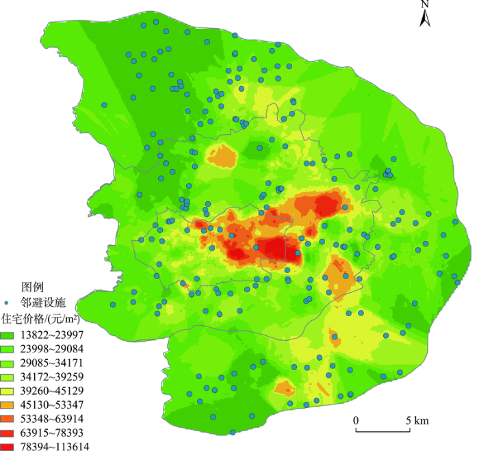
图2
广州主城区邻避设施与住宅价格空间分布
Fig.2
Spatial distribution of NIMBY facilities and housing prices in the core urban area of Guangzhou City
表3 广州邻避设施邻近小区统计
Tab.3
| 价格区间 /(元/m2) | 房价较低小区(即“低收入小区”) | 房价中等小区(即“中等收入小区”) | 房价较高小区(即“中高收入小区”) | ||||||||
|---|---|---|---|---|---|---|---|---|---|---|---|
| 13822~23997 | 23998~29084 | 29085~34171 | 34172~39259 | 39260~45129 | 45130~53347 | 53348~63914 | 63915~78393 | 78394~113614 | |||
| 数量/个 | 46 | 53 | 60 | 29 | 17 | 9 | 2 | 1 | 0 | ||
| 百分比/% | 21.20 | 24.42 | 27.65 | 13.36 | 7.84 | 4.15 | 0.92 | 0.46 | 0 | ||
邻避设施在广州主城区内的分布存在一定差异。近郊区多为低收入居民的聚集地,分布着垃圾处理场、殡仪馆、墓地和污水处理场等大型邻避设施;中心城区则多为中高档住宅,邻避设施分布较少且主要为加油站、垃圾站等小型邻避设施。因此,邻避设施与低收入人群的聚集地具有空间一致性,主要由低收入居民群体承担邻避设施带来的负外部性,从而导致这些群体有较强的动机反对邻避设施规划建设与运营。
3.2 邻避设施与周边住宅价格关系
3.2.1 参数估计与检验
表4 空间自相关结果
Tab.4
| 变量类型 | 变量名 | Moran's I |
|---|---|---|
| 主解释变量 | DisNIMBY | 0.437* |
| 控制变量 | RoomAge | 0.114* |
| DisCBD | 0.753* | |
| DisSchool | 0.366* | |
| DisSubway | 0.340* | |
| DisPark | 0.385* | |
| DisHospital | 0.379* |
注:*表示通过5%显著性水平检验。
基于上述空间自相关分析,以广州主城区内小区平均房价为因变量,以小区到距其最近邻避设施的距离为自变量,以房龄、到CBD距离、到最近学校的距离等6个变量为控制变量,利用ArcGIS软件分别进行多元线性回归和地理加权回归分析,并比较两者的R2、调整R2和AICc值(表5)。R2和调整R2反映模型的拟合优度,其值在0~1之间变化,值越接近1说明模型拟合效果越好。AICc综合反映模型的复杂度,当2个模型之间的AICc值差距大于3时,较小值模型为较佳模型[32]。结果显示,地理加权回归模型的R2和调整R2大于多元线性回归模型,且地理加权回归模型的AICc值小于多元线性回归模型,说明后期的分析选用地理加权回归模型最佳,邻避设施对小区房价的集聚性有较高解释力。
表5 多元线性回归模型和地理加权回归模型指标分析结果
Tab.5
| 模型 | AICc | R2 | 调整R2 |
|---|---|---|---|
| 多元线性回归模型 | 91048.640 | 0.329 | 0.328 |
| 地理加权回归模型 | 90204.103 | 0.464 | 0.456 |
3.2.2 地理加权回归结果分析
在上述分析基础上,采用ArcGIS软件对地理加权回归模型的回归系数进行可视化,研究邻避设施的距离与小区平均房价的关系。广州市主城区小区平均房价与小区和最近邻避设施距离的关系如图3所示。呈现正相关关系的小区空间分布具有3个特征:① 分布在5个高密度集聚区,即白云区、海珠区、天河区、黄埔区和番禺区,在这些区域距邻避设施越近的小区,平均房价越低,这体现了邻避设施的“邻避”特征。② 在越秀区的西北角出现一个范围较小的正相关小区密集区,附近的邻避设施有墓地、火车站、加油站和垃圾回收站。火车站虽然方便了居民出行,但其交通拥堵、噪声较大等因素容易引起周边居民的不满;在人们的传统认知中,墓地是不吉利的,会对附近居民的生活产生影响,其死亡象征意义更容易使周边居民产生害怕、恐惧、规避的心理[37]。同时,火车站和墓地对周边住宅价格会产生负面影响,但这种影响随着距离的增加而降低。③ 在白云区的南部,出现一条明显的分界线,其两边邻避设施对小区平均房价影响结果截然相反。在分界线东侧,邻避设施主要是加油站,且附近有“5号停机坪”购物广场、万达广场和凯德广场等购物中心,故邻避设施的“邻避”效应较小;在分界线西侧,邻避设施主要是加油站、加气站和垃圾处理设施,虽然这类邻避设施规模较小,但因其周边没有商业街、优质学校等[28],故邻避设施的负外部性更明显。
图3
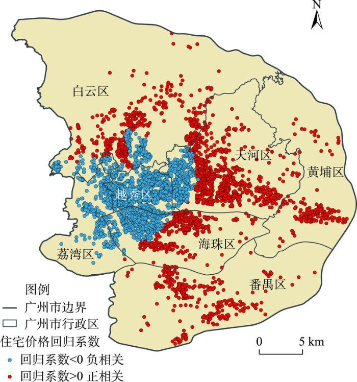
图3
地理加权回归模型的回归系数空间分布
Fig.3
Spatial distribution of geographically weighted regression coefficient
小区平均房价与小区和最近邻避设施距离呈现负相关关系的小区主要分布在荔湾区、越秀区、天河区西侧和海珠区西北侧,为广州的核心区。该区域主要分布着加油站、变电站和垃圾站等“邻避”特征并不明显的邻避设施。一方面,该类邻避设施地处城市核心区,有着良好的区位条件,周边拥有成熟的公共服务设施;另一方面,该类邻避设施占地面积较小,虽可能影响特定位置、朝向、楼层的房价,但并不会对大范围房价造成影响。因此,该区域内小区平均房价与小区和最近邻避设施距离呈负相关,并非是邻避设施的“邻避”效应不存在,而是邻避设施的负外部性较小,且所在地优越的区位条件带来的正外部性冲抵了负外部性。
此外,不同类型邻避设施对小区房价的影响程度也存在空间差异(图4)。以各类邻避设施中小区平均房价与小区和最近邻避设施距离呈现正相关关系的小区数量为依据,本文发现污染类、风险聚集类、心理不悦类等邻避设施对房价的影响程度大致相同,但污名化类的影响程度明显小于其他3类邻避设施。污名化类邻避设施的远近对小区平均房价的影响中,负相关区域明显大于正相关区域(11.23%的小区呈现正相关,88.77%的小区呈现负相关),正相关区域主要在番禺区、天河区和白云区接壤处。这可能是因为污名化类邻避设施对附近居民的危害最低,当周围出现强有力的影响因素(如优质学校、重要商业区、知名景点等)时,邻避设施的负面影响效果就会减弱。
图4
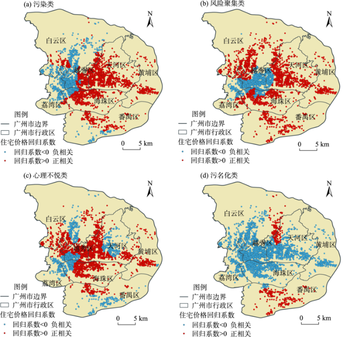
图4
各类邻避设施对广州小区房价影响的回归系数
Fig.4
Regression coefficient of the influence of various NIMBY facilities on housing prices of residential communities in Guangzhou City
污染类和风险聚集类邻避设施中,分别有66.87%和66.46%的小区平均房价与邻避设施的远近呈现正相关,且其主要分布在广州核心区以外的区域,邻避设施以垃圾转运站、废品站、加油站和加气站为主。这些邻避设施规模小、数量大,多建设在近郊区,故距邻避设施越近,房价越低。心理不悦类邻避设施中,有65.12%的小区房价与邻避设施远近呈现正相关,主要分布在海珠区、黄埔区、白云区、越秀区和天河区接壤处,邻避设施以骨灰楼、墓地为主,此类设施占地规模较大,且其象征的死亡意义容易让居民产生恐惧心理[37],故邻近这些设施的小区,房价相对较低。
4 结论与讨论
城市的正常运转,离不开垃圾处理场、殡仪馆、传染病医院等邻避设施。然而,邻避设施因其负外部性而受到周边居民的排斥,使得邻避冲突事件时有发生。因此,科学合理地规划布局邻避设施对于城市的和谐发展有着重要意义。本文基于邻避设施和小区房价数据,通过克里金插值法,分析了广州主城区邻避设施的空间分布特征,并基于地理加权回归模型,探讨了邻避设施与周边住宅房价的关系。具体结论如下:
(1) 邻避设施的分布与城市低收入人群的分布具有空间一致性和紧密性。广州主城区的邻避设施主要分布在低房价住宅区,超过70%的邻避设施分布在低于34171元/m2的住宅小区,而高于53348元/m2的住宅小区周边几乎没有邻避设施分布。从空间分区来看,近郊区相比中心城区,邻避设施分布密集。由于邻避设施周边地区的房价相对较低,因此,居住于此的市民多为低收入群体,这些群体因其社会地位的弱势而可能被迫面临环境不正义问题。
(2) 邻避设施对周边小区房价的影响与邻避设施的类型和区位相关。小区房价与邻避设施的距离呈现正相关的区域主要分布在广州的白云区、海珠区、天河区、黄埔区和番禺区。该区域的邻避设施主要有火葬场、墓地、发电厂、污水处理厂、化工厂等。这些邻避设施普遍规模较大,且地处城市较边缘地区,负外部性较明显,即距邻避设施越近的小区,房价越低,邻避设施明显影响了周边的房价。负相关区域主要分布在荔湾区、越秀区、海珠区西北侧和天河区西侧。该区域内邻避设施主要有加油站、变电站、垃圾站等。这些邻避设施普遍规模较小,且地处城市中心,城市中心良好的区位条件、基础设施与公共服务配套一定程度上抵消了邻避设施的负外部性。因此,邻近邻避设施并没有明显影响到房价。此外,污染类、风险聚集类、心理不悦类等邻避设施对房价的影响程度大致相同,但污名化类的影响程度明显小于其他3类邻避设施。
多数邻避设施主要邻近低收入居民群体分布,带来环境不正义问题,一方面在于邻避设施作为既需要政府投入,又不产生经济效益且具有负外部性的公共物品在“经济效益最大化”原则的驱动下往往被布局在级差地租较低的地方;另一方面,一些原本布局在城市边缘的公共服务设施,如垃圾转运站、污水处理厂、殡仪馆等,因城市快速扩张,被城市建成区包围,其产生的负外部效应影响了周边住宅的价格。不同类型和规模的邻避设施的负外部性存在较大差异,其周边的住宅价格也因此受到不同程度的影响。即便是同类邻避设施,不同的区位分布也会对周边住宅价格产生不同影响。在市场经济中,邻避设施的分配正义也许难以根本解决,但是认可正义与程序正义可以在相当程度上解决:一是邻避设施规划建设之前,要深入认识到可能带来的环境卫生和社会健康等不利影响,确保其选址尽可能不会严重影响到周边居民的身心健康和房产价值,并做好必要的物理阻隔和风险防范;二是为减轻邻避设施的负外部性影响,应在邻避设施附近有意识地规划建设具有正外部性的公共服务设施;三是邻避设施的规划建设,要严守程序正义,规划建设之前需广泛征求协调周边居民的意见建议,相关信息要公开透明,让各利益相关者能基于对称信息而理性地做出行为决策。
参考文献
邻避设施国内外研究进展
[J].
Progress in research of NIMBY facility home and abroad
环境正义、风险感知与邻避冲突的协商治理路径分析: 基于国内垃圾焚烧发电项目的案例思考
[J].
On deliberative governance path of environmental justice, risk perception and NIMBY conflicts: A case study of domestic refuse incineration power plant projects
Historical context and hazardous waste facility siting: Understanding temporal patterns in Michigan
[J].DOI:10.1525/sp.2005.52.4.618 URL [本文引用: 1]
Directional heterogeneity of environmental disamenities: The impact of crematory operations on adjacent residential values
[J].DOI:10.1080/00036840701721679 URL [本文引用: 1]
Environmental health risks and housing values: Evidence from 1600 toxic plant openings and closings
[J].Regulatory oversight of toxic emissions from industrial plants and understanding about these emissions' impacts are in their infancy. Applying a research design based on the openings and closings of 1,600 industrial plants to rich data on housing markets and infant health, we find that: toxic air emissions affect air quality only within 1 mile of the plant; plant openings lead to 11 percent declines in housing values within 0.5 mile or a loss of about $4.25 million for these households; and a plant's operation is associated with a roughly 3 percent increase in the probability of low birthweight within 1 mile.
The effect of power plants on local housing values and rents
[J].DOI:10.1162/REST_a_00119 URL [本文引用: 1]
Public opposition and the neighborhood effect: How social interaction explains protest against a large infrastructure project
[J].DOI:10.1016/j.landusepol.2018.08.045 URL [本文引用: 1]
Measuring externalities of waste transfer stations in Israel using hedonic pricing
[J].This study estimates the economic value of externalities related to waste transfer stations in Israel. Most externalities are associated with local disamenities experienced by residents living in close proximity to transfer stations - including noise, odor, litter, vermin, visual intrusion and any associated perceived discomfort. Following the mapping of all active transfer stations in Israel, problematic sites near residential areas were identified. Four of these sites were selected for detailed examination. The study involved estimating the economic value of disamenities using the Hedonic Price Method, which examines the impact of disamenities on property values. The results indicate that the maximum spatial extent of the impact occurs about 2.8km away from a transfer station with an increase of about $5000 in housing price for each additionalkm away from the site. Alternatively, an increase of 1% in the average distance of a house from the local transfer station is associated with a 0.06% rise in the price of the average house. These figures, representing the relationship between changes in environmental quality and property prices, indicate that transfer stations create externalities that should be taken into account in location and clean-up policies for transfer stations as well as in potential compensation policies.
环境邻避的冲突原理及其超越: 以双重博弈结构为分析框架
[J].
Causes of environmental NIMBY conflicts and solutions: With dual-game structure as an analysis framework
环境类邻避设施对北京市住宅价格影响研究: 以大型垃圾处理设施为例
[J].
DOI:10.11821/dlyj020190689
[本文引用: 2]

近年来,随着城市扩张,垃圾处理设施的布局逐步和城市居住空间相交叠,影响居民生活品质。目前人们对于北京市垃圾处理设施“围城”问题的认知多来自新闻媒体的宣传报道,存在一定的认知误差。以北京市六环内及周边街道为研究范围,分析垃圾处理及转运设施对房价的影响程度,以及垃圾处理设施对周边住宅价格影响的空间范围,在此基础上分析北京市最大的垃圾处理中心——阿苏卫对周边房价的影响范围。结果表明:① 北京市大型垃圾处理设施对周边房价影响的空间作用范围平均为6 km左右,这一距离远超市政建设要求的大型垃圾处理设施与居住区距离500 m的邻避标准。以此空间距离为基准测算,北京有800多个社区、约70万户居民处于大型垃圾处理设施的影响范围内。② 案例研究显示,阿苏卫垃圾处理中心对周边房价的影响范围接近14 km,远大于垃圾处理设施的平均空间作用距离。由于阿苏卫周边分布着回龙观、天通苑等大型居住区,受该设施影响的居民多达几十万人。
The impact of NIMBY facilities on housing prices in Beijing: A case study of large waste disposal facilities
DOI:10.11821/dlyj020190689
[本文引用: 2]
In recent years, with the expansion of cities, the distribution range of garbage disposal stations has gradually overlapped with urban living spaces, and affected the quality of residents' lives. In the past, people's perception of the problem of garbage sewers in Beijing came only from sensory impressions. In fact, garbage disposal sites and facilities only accounted for a small part of the “encirclement of the city”, but the scope of its impact on the living space is relatively large. The specific impact degree and scope need to be analyzed quantitatively to reach an objective conclusion. Taking the streets within the Sixth Ring Road of Beijing as the research scope, this paper analyzes the impact of waste treatment and transfer facilities on the housing price, as well as the spatial scope of the impact of waste treatment facilities on surrounding housing prices. On this basis, the impact range of Asuwei waste treatment center on the surrounding housing prices is analyzed. The results show that: (1) on average, large-scale waste treatment facilities in Beijing will affect the price of residential buildings within a distance of 6 km. This result is consistent with the previous results derived by scholars. There are 810 residential areas and nearly 700 thousand households in the affected area. (2) The impact of Asuwei waste treatment center on the surrounding housing prices reaches 14 km, which is far beyond the average impact range of waste treatment facilities and the protection distance specified in the construction standards.
污染型邻避设施对住宅房地产价格的溢出效应研究: 以广州市番禺区垃圾处理站为例
[J].
Spillover effects of polluting NIMBY facilities on residential real estate prices: A case of waste disposal stations in Panyu District
"Not on my block you don't": Facilities siting and the strategic importance of compensation
[J].
Understanding and overcoming the NIMBY syndrome
[J].DOI:10.1080/01944369208975808 URL [本文引用: 1]
机场设施邻避效应对北京市住宅价格空间影响研究: 以北京首都国际机场为例
[J].
DOI:10.11821/dlyj020210092
[本文引用: 1]
城市发展过程中,大型公共基础设施的建设运营与居民居住空间品质的优化提升之间的矛盾日益突出。随着城市更新的不断深入,实现规划用地高效合理利用与人民生活宜居和谐的双赢目标成为城市规划建设的重中之重。由于机场设施存在较为明显的负向外部性,其邻避效应对周围住宅价格产生影响。本研究对首都国际机场运用特征价格模型分析“同邻避设施的距离”对住宅价格的影响,表征了在不同要素影响下邻避设施空间效应的量度,同时分析得出其对住宅价格的影响范围半径。主要研究结论如下:① 首都机场设施对周边住宅价格存在负面影响。在一定范围内,到机场设施的距离每减少1%,住宅价格平均降低0.586%。不同要素的影响力也存在差异。② 机场设施对住宅价格的空间影响范围为10 km,其空间效应随“同机场风险源距离”的增加而表现出减弱的趋势。此外,影响范围内的小区有149个,83.2%的小区分布在顺义区,受影响的户数约为13万。③ 机场设施的邻避效应空间影响存在方向异性,位于机场西部和南部的区域对周边住宅价格的影响范围整体大于位于机场北部和东部的区域。
Spatial impact of airport facilities' NIMBY effect on residential price: A case study of Beijing capital international airport
DOI:10.11821/dlyj020210092
[本文引用: 1]
In the process of urban development, the contradiction between the construction and operation of large-scale public infrastructure and the optimization and improvement of residential space quality has become increasingly prominent. With the continuous urban renewal, it has become the top priority of urban planning and construction to realize the win-win goal of efficient and rational use of planned land and livable and harmonious life of the people. The Beijing Capital International Airport has negative effects on surrounding residents due to its electromagnetic radiation, noise and solid pollution. As a result, it has been subject to constant complaints from residents and long-term petitions for decision. Due to the obvious negative externalities of airport facilities, its NIMBY (Not In My Backyard) has an impact on the prices of surrounding houses. This research uses the Hedonic Price Model (HPM) to analyze the impact of "distance from NIMBY facilities "on the housing price of Beijing Capital International Airport, characterizes the measurement of the spatial effects of NIMBY facilities under the influence of different factors, and analyzes the range of influence on residential prices of Beijing Capital International Airport radius. The main research conclusions are as follows: (1) The capital airport facilities have a negative impact on the price of surrounding houses. Within a certain range, for every 1% decrease in the distance to airport facilities, the price of residential houses will decrease by 0.586% on average. The influence of different factors is also different. Among them, the noise level also has a greater influence on the price of housing, with an influence coefficient of 2.145. The distance between the residence and the subway station and bus station also has a greater impact on its own price. (2) The spatial impact of airport facilities on residential prices is 10 km, and its spatial effects show a weakening trend as the "distance from the airport risk source" increases. In addition, there are 149 communities within the affected area, 83.2% of which are located in Shunyi District, and the number of affected households is approximately 130,000. (3) The spatial influence of airport facilities on NIMBY effect has different directions. The areas located to the west and south of the airport have an overall greater impact on surrounding residential prices than the areas located to the north and east of the airport.
邻避型群体性事件及其治理
[J].
Governance of mass disturbance which caused by NIMBY
理论与范式: 面向21世纪的环境社会学
[J].
An environmental sociology for the twenty-first century
Beyond distribution and proximity: Exploring the multiple spatialities of environmental justice
[J].DOI:10.1111/j.1467-8330.2009.00691.x URL [本文引用: 2]
中国环境正义问题的凸显与调控
[J].
Environmental justice in China: Problems and solutions
邻避冲突的生成与化解: 环境正义的视角
[J].
The generation and solution of NIMBY conflicts from the perspective of environmental justice
广州市居民住房条件的空间分异格局与形成机制
[J].
DOI:10.13249/j.cnki.sgs.2017.06.008
[本文引用: 1]
以广州都市区1 361个社区的第六次人口普查住房数据为基础,从住房的建成年代、建筑结构、户均建筑面积、住房生活设施4个方面构建居民住房条件评价体系,分析其空间分异格局与形成机制。结果表明:① 广州市居民住房条件由中心向外围逐渐提升,具有“圈层基础上的多核心”式空间分异结构;② 户均建筑面积和建成年代是决定其住房条件差异的2项重要指标,旧城的住房条件异质性最高;③ 城市发展的历史进程、互换效应和过滤效应、高房价和高地价影响和强化了住房条件分异格局,制度性因素、政府决策和市场力量同时起到了引导和推动作用。
The spatial differentiation pattern and formation mechanism of housing conditions in Guangzhou City, China
DOI:10.13249/j.cnki.sgs.2017.06.008
[本文引用: 1]
The housing issues of China’s urban residents have always been the focus of academic circles. The issues regarding housing conditions in China's megalopolises are important topics of research for building livable cities, resolving the housing shortage, and solving the urban problem. The inequality of urban housing conditions is also an indispensable issue. However, to date, specific research on the differentiation pattern and spatial structure of housing conditions in China's cities is rare. Therefore, based on housing data from the newly available sixth census of 2010 for Guangzhou’s metropolitan areas, we established a comprehensive system for evaluating housing conditions that is composed of housing years, building structure, building area per household, and housing facilities and explored the spatial differentiation pattern of housing conditions. Furthermore, we analyzed the spatial cluster and heterogeneity of housing conditions by using the ESDA and GDI index. Finally, we summarized the spatial differentiation model and formation mechanism. The results are as follows: 1) The housing conditions of Guangzhou, gradually improving from the center to periphery, show significant imbalance and spatial cluster characteristics. Regions with better and worse housing conditions have specific location directions. Housing years and building area per household are two core indicators that decide the differentiation of housing conditions. 2) The housing conditions of the evaluation subsystem are distinct among different urban circles. In the old city, the scores of housing years, architectural structure, and building area per household are lower. In the core area, scores of the building area per household and housing infrastructure are higher than in other regions. In the central area, the level of the architectural structure is highest. In the suburbs, the housing years are the lowest. In addition, the heterogeneity of housing conditions in the old city is the highest. 3) The historical process of urban development, housing exchange and filtering effects, and high housing and land prices influence and enhance the spatial differentiation pattern of housing conditions in Guangzhou. Institutional factors, government decision making, and market forces also play a role in guiding and promoting the pattern. Thereto, institutional factors include the urban-rural dual-land system, housing dual-supply system, and housing demolition requisition system. Government decision making mainly refers to the urban development strategy and urban planning. Market forces reflect relationships between housing price, housing conditions, location, and household income.
北京市公共服务设施配置对住房价格的影响
[J].
Study on the influence of the allocation of public service facilities on housing price in Beijing City
大连城市绿地可达性对房价影响的差异性分析
[J].
DOI:10.13249/j.cnki.sgs.2018.12.002
[本文引用: 1]
研究房价、遥感影像等多源数据,采用邻域分析法和地理加权回归模型分析大连市中山区绿地可达性及其与房价之间的空间相关性。结果表明:① 房价均价14 745.35元/m<sup>2</sup>,呈环状分布,由沿海向内陆衰减、桂林街道起中心向外围递减;② 研究区内可达性最好的绿地类型是街旁绿地,绿地可达性总体水平最高街道是桂林街道;公园绿地可达性最好的住宅区分布在昆明街道和桃源街道,街旁绿地可达性最好的住宅区分布在桂林街道,附属绿地可达性最好的分布在老虎滩街道,其他绿地可达性最好的分布在桃源街道。③ 不同类型绿地可达性对房价影响作用程度递减排序为:附属绿地、街旁绿地、公园绿地和其他绿地;附属绿地、街旁绿地和其他绿地与房价呈现空间正相关,随着到达绿地距离降低,房价呈现增长趋势;公园绿地与房价呈现负相关,随着到达公园绿地的距离降低,房价呈现衰减趋势。
The impact of urban green space accessibility on house prices in Dalian City
DOI:10.13249/j.cnki.sgs.2018.12.002
[本文引用: 1]
This article studies the relationship between urban green space accessibility and house prices in Zhongshan District, Dalian, by near analysis, geographically weighted regression model and multi-source data (e.g., house prices and green space). The results are as follows: First, the average house price is 14 745.35 yuan/m2, and reveals a declining trend from coastal areas to inland areas, except Guilin Street, which demonstrates a local peak of house prices that decreases from the center of the street to its periphery. Second, street park green spaces show the best accessibility, and the overall accessibility of the green space for Guilin Street is the highest; The residential areas of best theme park green space accessibility are located on the Kunming streets and the Taoyuan streets; The residential areas of best street park green space accessibility are located on the Guilin Street; The best accessibility of attached green space is distributed on the Tiger Beach streets; With the best accessibility of other green space distributed on the Taoyuan streets. Third, the influence of green land accessibility on housing prices decreases with green land types as attached green space, street park green space, theme park green space, and other green space; Attached green space, street park green space and other green space show the significant spatial correlation coefficient between green space accessibility and house prices, house prices show a trend of growth as the distance to the green land falls; There is negative correlation between theme park green space and house price, with the arrival of scenic parks green spaces decreased, house prices showed the decrease trend.
上海市三甲医院对周边地区住房价格的空间影响效应分析
[J].
DOI:10.13249/j.cnki.sgs.2015.07.860
[本文引用: 2]
选取上海市区7家三级甲等综合性医院,运用特征价格模型和多元回归分析方法,实证分析它们对周边住宅价格的空间影响效应。研究结果显示:① 总体上,相比其他环境区位因素,三甲医院对周边住宅价格的影响程度较小,而建筑面积、物业管理费、学区房、轨道交通、建筑楼高、至 CBD 的距离等因素的影响程度较大。② 三甲综合医院对周边住宅价格产生负面影响。在相同情况下,住宅离医院距离越近,则价格越低。住宅与医院的距离每缩短50 m,住宅价格平均下浮0.602%。③ 由于三甲综合医院区位各不相同,距离CBD远近不一,对住宅价格的影响也存在空间差异。一般来说,距离CBD越近,住宅价格受医院的负面影响也越小。
The spatial impacts of class 3A comprehensive hospitals on a peripheral residential property prices in Shanghai
DOI:10.13249/j.cnki.sgs.2015.07.860
[本文引用: 2]
How to evaluate the impacts of urban public resources and facilities on the price of real estates has been the research topic in academic circles for a long time. Relative to the other urban public facilities such as subway stations or rail transit, large-scale parks and greenbelt, landscape water, universities or key primary and middle schools and so on, the relationship between hospital and housing prices has not caused enough attention. In this article 7 Class 3A comprehensive hospitals in Shanghai urban central areas were selected, using the Hedonic price model and multiple regression analysis method, to conduct an empirical analysis of the spatial effect of these hospitals on residential property prices. The results show as follows: 1) Generally speaking, compared to other environmental factors, the less impacts of Class 3A comprehensive hospitals were corducted on the surrounding residential property prices, and the factors such as building area, property management fees, school-nearby houses, rail transit, height of buildings, the distance to the CBD have greater influence on housing prices. 2) Class 3A comprehensive hospitals have a negative impact on the surrounding residential property prices. And in the same circumstances, as shortening the distance of houses to the hospital each 50 m, the average housing price fell 0.602%. 3) Because of the different location and distance to the CBD of Class 3A comprehensive hospitals, there is a spatial differencine in their impact on housing prices. In general, the closer distance to CBD is, the less negative influence housing price is affected by the hospital.
基于住宅价格视角的居住分异耦合机制与时空特征: 以南京为例
[J].
DOI:10.11821/dlxb201704003
[本文引用: 1]
城市住宅价格空间分异,是居住空间资源非均衡配置的市场化表达,映射出不同阶层社会群体对城市住宅的选择倾向与需求差异,与居住空间分异在机制和格局上存在一定耦合关联。以南京主城区商品房社区为研究对象,构建起住宅价格特征变量指标体系,采用地理加权回归模型,分析导致房价空间差异的主要因素、组合关系及时空演变特征。研究发现:社区服务档次、学区资源、环境区位、景观稀缺等能够体现居住群体经济实力、生活方式与文化品位的因素,是影响房价分异的主导要素并随时间不断强化;南京房价总体上呈现“圈层+扇形+飞地”的空间结构,高房价主要分布在城市中心、名校学区、高档封闭社区和山水景观别墅区;房价分异与居住分异在作用机制和空间格局上表现出显著的关联耦合特征。城市房价空间分异不止于表达,同时也是推动居住空间分异与再分化的重要驱动机制,并能够预判未来一段时期内城市居住空间分异格局演变的基本走势,可以为城市社会空间研究提供具有前瞻性的观察视角和分析工具。
Coupling mechanism and spatial-temporal pattern of residential differentiation from the perspective of housing prices: A case study of Nanjing
DOI:10.11821/dlxb201704003
[本文引用: 1]
Spatial differentiation of urban housing prices is the marketization expression of the non-equilibrium allocation of residential space resources, which reflects the contrast between social groups belonging to different social classes in selection preference and demand for housing. There is a certain degree of correlational coupling between urban housing prices' spatial differentiation and residential spatial differentiation with respect to the mechanism and the pattern. The paper chooses 1204 commercial housing communities in Nanjing's urban center as its research object and constructs a characteristic variable index system of housing prices. The GWR model is used to analyze major factors that lead to spatial differentiation in housing prices, as well as their combination relationship and spatial-temporal dynamics. Results demonstrate that: (1) there are various factors affecting housing prices, their subsequent spatial differentiation, and they are likely to evolve over time. The dominant factors are the level of the community, school district resources, quality of the landscape, access to leisure facilities, and so on. These may mainly reflect housing consumers' earning capacity, values, residential environment demands, life style and cultural tastes. (2) The pattern of housing prices in Nanjing generally shows the spatial pattern of "circle + fan-shaped + enclave". High priced housing mainly includes new apartments and gated communities in the inner city, communities in elite primary and secondary school districts, high-grade gated communities close to the Ming City Wall, housing in the center of Hexi New Town, and landscaped villas in the urban periphery. (3) Differing types and strata of housing communities attract and gather consumer groups with specific economic and social attributes, which makes housing price differentiation notable correlational coupling with residential differentiation in acting mechanisms and spatial patterns. As the degree of urban housing marketization is continuously deepening and the cultural characteristics and residential preference of social classes become increasingly mature, the spatial differentiation of urban housing prices is more than just an expression. It is also an important driving mechanism to promote residential spatial differentiation and re-differentiation, and can also predict basic trends pertaining to urban residential spatial differentiation in the future. Therefore, the spatial differentiation of urban housing prices can provide a prospective observational and analytical tool for the study of urban social space. It can further make up the time-lag defect which arises in traditional social space research using census data, as well as helps to predict and identify future trends regarding urban social spatial differentiation.
学区对住宅价格的影响及其社会空间重构研究: 以武汉市武昌区为例
[J].
DOI:10.18306/dlkxjz.2022.04.006
[本文引用: 1]
2014、2015年教育部接连发文要求落实“免试就近入学”政策,由此公立初小的入学资格与住房紧密挂钩。在此背景下,初小教育资源如何影响住宅价格,并带来怎样的城市社会空间变化是有意义的科学问题。论文基于安居客、链家、百度开放平台及问卷访谈等数据,综合运用特征价格模型、地理加权回归模型等方法,以武汉市武昌区为实证区域,探索学区对住宅价格的真实影响,并尝试从“空间生产”入手,探究学区引发的城市社会空间重构。研究发现:① 学区特征对住宅价格的影响已超过传统区位、建筑、邻里特征等的影响;② 学区房提供了资本由二级循环进入三级循环的便利路径,形成了学区空间生产与社会空间新分层的宏观基础;③ 微观层面,对优质学区的争夺产生了“学区人”和“学区空间”,进而出现学区飞地,对传统城市社会空间产生影响;④ 不同于“单位人”与“社区人”,“学区人”并不主要依靠职业或收入划分,而是因相似的家庭生命周期发生关联。
Influence of school districts on housing prices and the effect on socio-spatial restructuring: Taking Wuchang District of Wuhan City as a case
DOI:10.18306/dlkxjz.2022.04.006
[本文引用: 1]
Since the Ministry of Education of China issued a series of documents requiring the implementation of the policy of nearby enrollment without entrance exam in 2014 and 2015, the enrollment qualifications of public primary and secondary schools have been linked to housing property. In this context, it is of significant value to explore how the primary and secondary school education resources affect housing prices and how the resulting urban socio-spatial restructuring takes place. Based on the data from open platforms of Anjuke, Lianjia, and Baidu and survey questionnaire and interview data, this study took Wuchang District of Wuhan City as the case area to explore the real influence of school districts on housing prices through adopting the hedonic price model, geographically weighted regression (GWR) model, and other technical methods. Moreover, starting with the concept of "production of space", this study explored the effect of school districts on urban socio-spatial restructuring. The results show that: 1) The impact of the characteristics of school districts on housing prices has exceeded the traditional housing characteristics, such as location, architecture, and neighborhood. 2) Housing within the high school district provides a convenient path for capital inflow from secondary to tertiary circuits, forming a macro basis for the production of school districts as well as a new stratification of social space. 3) At the micro scale, the competition for high-quality school districts has produced "people of school districts" and "space of school districts", and then enclaves of school districts have emerged, which has an impact on the traditional urban social space. 4) Unlike the "danwei (workplace) people" and "community people", the definition of "people of school districts" does not mainly rely on occupational or income divisions, but is associated with families of similar life cycles.
DEM空间插值方法对土壤侵蚀模拟的影响研究: 以USPED分析干热河谷典型冲沟为例
[J].
DOI:10.18306/dlkxjz.2016.07.008
[本文引用: 1]
为探索不同空间插值方法得到的DEM如何影响土壤侵蚀模拟效果,本文选择金沙江干热河谷区典型冲沟为研究对象,利用野外测量高程数据,采用反距离加权(IDW)、析取克里格(DK)、局部多项式(LPI)和张力样条函数(ST)4种方法构建高精度DEM。基于USPED模型模拟冲沟的土壤侵蚀,对比不同空间插值方法的精度、土壤侵蚀的空间分布,采用相对差系数对比不同插值在土壤侵蚀研究中的相似性。结果表明:DEM空间插值的精度排序为ST
Effects of different DEM spatial interpolation methods on soil erosion simulation: A case study of a typical gully of dry-hot valley based on USPED
DOI:10.18306/dlkxjz.2016.07.008
[本文引用: 1]
Digital elevation models (DEMs) have been widely used in soil erosion simulation, but how different interpolation methods affect the simulation results is not well researched. In this article, a typical gully in the dry-hot valley of the Jinsha River was selected as the case study area. First, field measurement of elevations of the gully was preformed. Inverse Distance Weighted (IDW), Disjunctive Kriging (DK), Spline with Tension (ST), and Local Polynomial Interpolation (LPI) methods were then used to produce high-precision DEMs of the gully. The United Stream Power-based Erosion Deposition (USPED) model was used to simulate the spatial distribution of erosion and deposition in the gully. The coefficient of relative difference was used to analyze the similarity of USPED results. The result shows that the precision of DEMs from high to low is: DK, LPI, IDW, and ST. The results of USPED simulation show that DK revealed the main distribution pattern of erosion and deposition, but IDW highlighted the details, and LPI and ST were in-between. The coefficient of relative difference shows that IDW was similar with other interpolation methods in soil erosion simulation, but when the layout of sampling points is reasonable and the density of the sampling points is sufficiently high, IDW is more suitable for soil erosion simulation using USPED.
Geographically weighted regression and multicollinearity: Dispelling the myth
[J].DOI:10.1007/s10109-016-0239-5 URL [本文引用: 2]
基于地理探测器和GWR模型的中国重点镇布局定量归因
[J].
DOI:10.18306/dlkxjz.2020.10.008
[本文引用: 1]
重点镇是小城镇发展的龙头,形成科学合理的重点镇布局对优化中国城市化战略格局有重要意义。论文以2004年和2014年分别公布的1887个和3675个全国重点镇为样本,对其分布及效应的变动特征进行探究,进而在地级尺度对重点镇布局的影响因子及其作用进行地理探测和局部空间回归。结果表明:① 经增补调整,中国重点镇布局及建设效应的均衡性增强,主要集聚区西移北扩,冷热点的分布突破“胡焕庸线”,经济辐射效应的分化程度减弱,体现出政策因素的有力影响。除县际均衡和区域倾斜政策外,重点镇的分布还受到海拔高度、公路网密度、常住人口城镇化率等因子的显著作用。② 因子探测器、GWR模型和交互作用探测器的结合能更精准地刻画影响因子的作用方式、方向、路径和强度。中国重点镇的布局不是5个显著性因子均匀、独立、直接作用的结果,而是影响均具空间异质性的各因子两两交互作用后增效的产物。③ 县际均衡政策与其他因子的协同作用是形成现有重点镇分布格局的主导力量;区域倾斜政策的效果总体较好,但目标区域还需更准确。
Quantitative attribution of national key town layout based on geodetector and the geographically weighted regression model
DOI:10.18306/dlkxjz.2020.10.008
[本文引用: 1]
National key towns are the leader in the development of small towns. The formation of scientific and reasonable national key town layouts is of great significance for optimizing China's urbanization strategy. Taking the 1887 and 3675 national key towns published in 2004 and 2014 respectively as samples, this study used geodector and the geographically weighted regression (GWR) model to explore the changing characteristics of their distribution and analyze the influencing factors of national key town layouts and effects at the prefecture level. The results show that: 1) After the adjustment by the government, the balance of the layout and construction effect of national key towns is enhanced. The main gathering areas moved westward and northward, the distribution of cold spots and hotspots break through the "Hu Huanyong Line", and the degree of differentiation of economic radiation effect is weakened, reflecting the powerful influence of policy factors. In addition to the inter-county balance and regional preferential policies, the distribution of national key towns is also significantly affected by factors such as altitude, road network density, and resident population urbanization rate. 2) The combination of the factor detector, the GWR model, and the interaction detector can more accurately characterize the mode of action, direction, path, and intensity of the influencing factors. The layout of national key towns is not the result of the uniform, independent, and direct effect of the five significant factors, but the product of the synergistic effect of the interaction of the factors with spatial heterogeneity. 3) The synergy between the inter-county balance policy and other factors is the dominant force in the formation of the existing layout of the key towns; the effect of the regional preferential policy is overall positive, but the target areas need to be more accurately identified.
中国传统村落空间分布特征与影响因素分析
[J].
Spatial distribution characteristics and influencing factors of Chinese traditional villages
中国城市房价、收入与房价收入比的时空分异格局
[J].
DOI:10.11821/dlyj020200817
[本文引用: 1]
中国城市房价快速增长背景下,城市房价、收入与房价收入比空间格局既有相似性,也表现出差异性,其空间异质性与空间依赖性特征显著。本文以中国337个地级行政单元为研究对象,运用泰尔指数、位序-规模和空间马尔科夫链等方法,对2009—2018年中国城市房价、收入和房价收入比的时空分异格局、整体稳定性和空间依赖性特征进行分析发现:① 中国城市房价增长呈现出波动性特征,整体分异程度增强,房价城市体系呈现“金字塔型”结构,收入则表现出平稳增长态势,整体分异度降低,城市体系呈现“橄榄型”结构,在房价与收入共同影响下,房价收入比整体差异性显著加强;② 城市房价空间格局表现出“地带性”与“等级性”差异并存,而收入更多表现出“地带性”差异,房价收入比则以“等级性”差异为主;③ 城市房价和收入类型的稳定性和空间依赖性较强,高、低水平城市存在两极分化与“俱乐部收敛”现象,房价收入比稳定性相对较弱。对中国城市房价、收入和房价收入比时空分异格局和空间关联效应的分析,可以为探索中国城市房价收入比空间分异模式与机理提供必要研究基础。
The spatiotemporal differentiation pattern of Chinese urban housing price, income and housing price-to-income ratio
DOI:10.11821/dlyj020200817
[本文引用: 1]
Amid the fast-growing housing price in Chinese cities, the spatial pattern of urban housing price, income and housing price-to-income ratio shows both similarities and differences, characterized by internal spatial heterogeneity and spatial dependence. This paper targets 337 prefecture-level administrative units and applies the Theil index, rank-size and spatial Markov chain to the analysis of the spatiotemporal differentiation pattern, overall stability and spatial dependence of Chinese urban housing price, income and housing price-to-income ratio from 2009 to 2018. It finds the following results. Firstly, the growth of Chinese urban housing price is phase-based and fluctuated. When the overall differentiation enlarges, the urban system of housing price takes on a structure of “pyramid” and income shows sustained and stable growth. When the overall differentiation shrinks, the urban system presents a structure of “olive”. Under the combined influence of housing price and income, the overall differentiation of housing price-to-income ratio is obviously strengthened. Secondly, housing prices, income and housing price-to-income ratios in Chinese cities are all spatially heterogeneous and agglomerated. The spatial pattern of housing price is different in both zonality and hierarchy, while income is particularly different in zonality and housing price-to-income ratio is particularly different in hierarchy. Due to the coexistence of similarities and differences between housing prices and income patterns in Chinese cities, the housing price-to-income ratio pattern presents a more complex and discrete structure. Thirdly, the stability and spatial dependence of urban housing price and the type of income is stronger, while the stability of housing price-to-income ratio is relatively weak as there are polarization and club convergence in cities at different levels. Housing prices to the north of the "Hu Huanyong Line" shifted downwards, income shifted upwards, and the housing price-to-income ratio declined. In the southern regions, housing prices generally rose rapidly, with income shifts showing stable in the east, downwards in the central region, and upwards in the west, leading to the discrete and broken pattern of housing price-to-income ratios. Moreover, the type shifts of urban housing price, income and housing price-to-income ratio are not spatially independent, but related to the neighboring cities. The analysis of the spatiotemporal differentiation pattern and spatial correlation effect of Chinese urban housing price, income, and housing price-to-income ratio lays a foundation for research on the spatial differentiation pattern and mechanism of Chinese urban housing price-to-income ratio.
节能减排约束下中国省域旅游生态效率评估及空间格局研究
[J].
DOI:10.18306/dlkxjz.2021.08.003
[本文引用: 1]
旅游生态效率评估及空间格局研究是揭示中国省域旅游业发展质量与态势的重要基础。论文以“自下而上”法核算中国省域旅游能源消耗与碳排放为基础,综合运用考虑非期望产出的Super-SBM模型、Malmquist指数及探索性空间数据分析等方法,探究节能减排约束下2000—2017年中国省域旅游生态效率及其空间分异、收敛和关联格局。结果表明:① 旅游能源消耗与碳排放总体呈先增长、后下降的倒“U”形演化趋势,支持环境库兹涅茨曲线(EKC)假说;② 旅游生态效率总体呈波动增长趋势,并有较大增长潜力,纯技术效率驱动生态效率优化发展;③ 旅游生态效率在省域、地区尺度上均呈现空间分异格局,但趋向收敛平衡发展;④ 旅游生态效率呈现由强到弱的正向空间关联格局,其发展模式以低—低集聚为主,低—高集聚次之,空间集聚模式待优化。各省区应以生态效率水平较高的地区为基准,通过要素流动、规模效应、技术进步及环境规制等手段,实现旅游业高质量协调发展。
Tourism eco-efficiency at the provincial level in China in the context of energy conservation and emission reduction
DOI:10.18306/dlkxjz.2021.08.003
[本文引用: 1]
The study on the evaluation and spatial pattern of tourism eco-efficiency is an important basis for revealing the quality and state of tourism development at the provincial level in China. Based on a bottom-up approach to calculate tourism energy consumption and carbon emissions at the provincial level in China, this study used the Super-SBM (slacks-based measure) model, Malmquist index, and exploratory spatial data analysis to explore the spatial differentiation, convergence, and correlation patterns of tourism eco-efficiency at the provincial level in China in the context of energy conservation and emission reduction. The results show that: 1) Tourism energy consumption and carbon emissions generally show an inverted U-shaped trend that first increases and then decreases, which supports the environmental Kuznets curve (EKC) hypothesis. 2) The overall tourism eco-efficiency shows a fluctuating growth trend, and has great growth potential. Pure technical efficiency drives the optimized development of eco-efficiency. 3) At the provincial and regional scales, tourism eco-efficiency presents a spatial differentiation pattern, but tends to convergence and reach balanced development. 4) Tourism eco-efficiency presents a positive spatial correlation pattern from strong to weak, and its development model is dominated by low-low agglomeration, followed by low-high agglomeration, and the spatial agglomeration model needs to be optimized. All provinces and regions should take the areas with higher eco-efficiency as the benchmark, and realize the coordinated development of tourism with high quality by means of factor flow, scale effect, technological progress, and environmental regulation.
