钟炜菁 , 王德
, 王德
ZHONG Weijing, WANG De
通讯作者:
收稿日期: 2017-11-3
修回日期: 2018-01-7
网络出版日期: 2018-09-04
版权声明: 2018 地理科学进展 《地理科学进展》杂志 版权所有
基金资助:
作者简介:
作者简介:钟炜菁(1991- ),女,江西赣州人,硕士,规划师,研究方向为城市空间与行为、数据分析,E-mail: wjzhong0705@126.com。
展开
摘要
伴随着中国经济社会进入“新常态”的发展阶段,对城市存量空间的研究提出了更加精细化的要求,基于居民行为活动的周期规律对城市空间进行研究,进而提升城市空间的品质日益重要。随着信息通信技术的快速发展,使许多大数据的获取成为可能,并由于其低成本、即时、大样本等优势,在城市空间研究方面具有巨大的价值。以上海市中心城区为例,利用手机信令数据,探究居民活动的空间周期变化特征,并基于空间的周期特征曲线,采用相似性传播聚类算法进行空间分类。研究表明,居民活动有平日一日周期和平日加周末二日周期,与人的作息规律相符合。市核心区、城市副中心及主要就业中心,昼夜波动和平日周末活动强度的差异都较为明显。空间分类结果显示,城市活动空间的组织既体现出个体充分的空间能动性,也反映出对土地使用类型以及设施建设、投入程度的耦合性。上海市内环内核心区混合多样的用地模式使得活动区内居民活动内容丰富,周期特征功能区边界模糊。研究成果可为未来的城市空间规划提供指导,为城市空间结构、功能布置、设施布局等优化提供决策支撑和科学依据。
关键词:
Abstract
As the development of economy and society enters into the "new normal" stage in China, urban planning is also gradually transformed from the traditional incremental planning to inventory planning. It is important to explore the urban spatial dynamic functional characteristics, and to optimize the use of urban activity space based on people's needs, which would enhance the quality of urban space. Advancements of information, communication, and location-aware technologies have made collections of various passively generated datasets possible. These datasets provide new opportunities to understand spatial dynamic characteristics at a low cost and large scale. This study explored the classification of urban space and spatial dynamic characteristics based on a large mobile phone location dataset from Shanghai Municipality, China. The results suggest that the geographical differences of spatial dynamic patterns in Shanghai are evident. The diurnal activity curve is consistent with the patterns of human activity. There were significant differences in intensity of day-to-day activity fluctuations and weekday activities between downtown, sub-centers, and major employment centers. Affinity propagation clustering was introduced to identify the characteristics of urban spatial structure and identify the characteristics of urban space structure of liquidity and viscosity. Several distinct patterns were extracted, and the spatial distributions of the derived clusters highlight distinct human mobility patterns in different areas of the city. We then discuss the socioeconomic and demographic characteristics of the regions covered by different cluster types to gain insights of human mobility patterns in the context of urban functional regions. The findings could offer useful information for policy and decision making.
Keywords:
以人的行为活动作为焦点,自下而上地对人的行为分析探求背后的空间综合效应,是深入认识城市空间活动特征必不可少的技术路线。传统的城市空间研究以建成环境、土地利用类型等静态、物质性的研究为主(Clark, 1951)。从1970年代开始,在人本主义和后现代主义等思潮的影响下,西方的城市空间研究出现了社会转向、行为转向及人本转向。2016年召开的联合国第三次住房和城市可持续发展大会,也紧紧围绕“全球城镇化进程中可持续的人居发展”主题,强调从城市每一位居民需求出发来营造城市空间,最终实现“建设包容、安全、有抵御灾害能力和可持续的城市和人类住区”的愿景。在研究方法上,关注城市社会结构、个体时空行为、个人主观能动性,强调个体移动过程的行为主义地理学、时间地理学、活动分析法等方法论奠定了居民时空间行为研究的理论方法基础,为理解人类活动和城市环境之间在时空间上的复杂关系提供了独特的视角。行为主义地理学强调人的主观认知与选择,试图了解人们的思想、感观、对环境的认知,以及空间行为决策的形成和行动后果(Gollege, 1997)。时间地理学强调人受到的制约以及围绕人的外部客观条件,将时间和空间在微观个体层面上相结合,通过时空路径、时空棱柱、制约等概念及符号系统构建其理论框架(Hagerstrand, 1970)。活动分析法对时间与空间、选择与制约、活动与移动的关系在城市活动—移动系统中进行综合考虑(柴彦威等, 2008)。以时间地理学、行为主义方法论、活动分析法等为核心的居民时空间行为研究,基于多元数据与不同活动类型等,立足日常生活,关注个体与家庭,聚焦时空间行为,可以多尺度透视城市时空间体系,解释城市的建成环境和制度背景对个体时空间行为活动的影响(张文忠等,2006; 朱玮等, 2008)。在中国建设人本城市的形势下,基于人的行为特征的空间研究也得到不断发展,尤其是时空间行为理论引入中国以来,已经成为中国城市规划和城市地理学研究的重要领域(柴彦威等, 塔娜, 2013)。从已有研究来看,在基于行为特征的空间研究方面,对单一类型的活动空间研究较多,对多种行为空间叠加的综合活动空间研究较少;对单一案例地区的行为空间进行了一些深入的研究,对城市整体的活动空间结构及其分布模式缺少一个清晰的认识;由于个体时空信息获取途径的有限性,对城市整体的活动空间的周期特征研究仍有待进一步挖掘(柴彦威, 申悦等, 2013)。
随着信息技术的发展,获取大量动态的、带有精准空间信息的个人数据成为可能,大数据的价值得到越来越多的重视(Liu et al, 2015; 杨振山等, 2015; 甄峰等, 2015),且已广泛运用到时空间行为研究(秦萧等, 2013)、城市特定区域的识别和空间结构的认识(吴康敏等, 2016; 谢永俊等, 2017)、地铁站等设施类型的识别(尹芹等, 2016)、城市感知(杨微石等, 2017; 易峥等, 2017)等研究中,并且探讨了基于时空轨迹(龚玺等, 2011)、基于特征的时间序列(宋辞等, 2012)等大数据的聚类方法。其中,手机信令数据,其具有的精细化个体信息、实时动态性和近乎全覆盖性,成为地理研究和城市规划中时空间行为研究的有力工具。已发表许多重要研究成果(郭璨等, 2014; 王德, 王灿等, 2015; 王德, 钟炜菁等, 2015; 钟炜菁等, 2017)。在城市空间结构和功能识别研究领域,已有国内外研究学者根据手机数据的时空分布绘制出揭示人们在城市空间中活动规律的动态地图(Calabrese et al, 2011),尝试根据区域的话务量随时间的不同变化曲线,区分城市不同区域和功能的土地利用特征(Calabrese et al, 2010);验证手机话务量与城市社会经济结构的相关关系(Sevtsuk et al, 2008);通过手机数据判断城市中的人口密集区(Rubio et al, 2013; 钮心毅等, 2014),通过聚类(Pei et al, 2014)、不同区域的人口流入和流出记录量(Yang et al, 2016)等方法对城市空间进行分类。这些研究成果充分表明对城市空间的周期特征研究正是手机信令数据的优势所在,具有重要研究价值。
基于此,本文以上海市中心城区为例,充分利用手机信令数据这一大数据所具有的大样本、动态性、具有个体维度的优势,选择居民行为活动的时间维度为研究视角,探究居民的空间行为活动在时间维度上的周期特征,包括平日昼夜活动的差异特征,以及平日与周末活动的差异特征,并基于居民行为的周期特征,进行空间划分,以期增强对城市空间活动的周期特征的认识,为基于居民行为的周期特征提升空间品质提供参考和依据。
本文主要采用的是2014年上半年某两周上海移动2G用户产生的手机信令数据。数据通过与移动运营商合作获取,为匿名形式,每条信令数据包含用户ID、时间戳、基站位置编号、事件类型(如接打电话、接发短信、位置更新)等信息。本文数据日均记录到上海1500~1900万个不同的手机识别号(约占2014年上海2425万常住人口( 根据《上海市统计年鉴(2015)》,上海全市年末常住人口为2425.68万人。)的70%),日均信令记录总数约5~9亿条左右;在空间分布上,全市域约36000个基站,其中,中心城区17788个基站,间距约100~300 m。手机信令数据具有的动态、连续、几乎城乡空间全覆盖,且持有率高(2根据《上海统计年鉴2014》,上海2013年移动电话普及率为132.5%。)的特征,可较好地反映人们总体的时空间行为规律(图1)(3土地利用图(中)来源于上海市土地利用现状图(2014年),其他笔者自绘。)。
图1 上海中心城区(外环线以内)区位(左)、土地利用现状(中)和基站分布(右)
Fig.1 location and land use of the city center of Shanghai, and location of base station
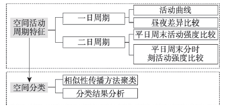
研究整体分析框架如图2所示,按照“特征描述—空间分类”的逻辑顺序,首先,从对上海市中心城区空间活动的周期特征分析入手,发现城市空间活动的两个主要特征,即平日一日周期和平日加周末的二日周期,从活动曲线、昼夜差异比较、平日周末活动强度比较等角度具体分析这两个主要周期特征;其次,在此空间活动的周期特征认识的基础上,根据相似性与差异性,将具有相似时间周期特征的空间进行聚类,以区分城市中心区城市空间的不同类型。通过对分类结果的解释分析,形成基于居民行为周期特征的上海市中心城区活动空间的新认识,为空间活动品质的提升、优化提供参考和依据。
2.3.1 空间单元选择
本文中手机位置只能精确到基站的服务单元,为消除可能存在的乒乓切换(4 现实中,基站的蜂窝服务范围并不是理想中边界清晰、易于划分的六边形,而是存在重叠,如果在一定区域内基站信号发生剧烈变化,就可能导致手机在不同基站之间频繁切换,即乒乓切换现象。)而导致对居民位置识别和统计上的误差(Iovan et al, 2013; Vajakas et al, 2015),研究对基站进行合并,合并后中心城区共7608个基站。在此基础上,以栅格为空间单元进行分析。考虑到基站间距以200~300 m为主,研究以200 m×200 m的栅格单元将上海中心城区划分为16962个栅格(5在核密度分析进行可视化时,考虑显示效果,采用100 m×100 m的栅格单元。)。将各基站的记录数以核密度的方法分散到各栅格空间,作为该栅格空间的记录强度。为处理手机信令数据由于基站在不同空间分布的疏密程度不一问题,研究采用自适应半径的核密度分析方法,即依据上海基站的服务半径一般设置在300~1500 m范围的现实情况,研究根据基站所在区域的基站分布疏密程度在上述范围内自动调整核密度分析时的搜索半径。
在空间分布特征的可视化方面,本文借助ArcGIS软件,实现以基站为单位记录的记录强度值,通过上述自适应半径的核密度分析方法,形成以栅格为单位的空间核密度图。实践表明,该方法对于整体记录强度分布特征的揭示、尤其是集聚特征的表达具有良好的效果。
2.3.2 数据处理和指标构建
(1) 城市整体活动曲线
对两周内的10个平日内,中心城区各基站的总记录量以2小时为时间单元(6由于本次数据的自动更新周期普遍为两小时,以两小时为时间单元,可避免因自动更新带来的数据误差。)进行平均统计,并计算各时段记录量占一天总记录数的比例
式中:k为基站编号(k=1, 2, …7608);
计算每个时段的
(2) 栅格空间数据统计向量构建
原始数据为每个用户在各基站产生的单条记录,利用相关统计软件,基于前文所述的以栅格为空间单元的自适应半径的核密度分析,对每一个栅格内,以2小时为时间单元,构建一个记录强度统计向量T,公式如下:
式中:k为栅格单元编号(k=1, 2, …16962);
对工作日(周一至周五,两周共10天)和周末(周六和周日,两周共4天)的记录强度数据进行相关性分析,结果显示,不同工作日内相同时间段的记录量数据在0.01水平上呈现显著相关,因此,对10天工作日和4天非工作日的数据分别计算记录量,再除10天工作日和4天非工作日,计算得到日均记录数,将数据维度由168维度降至24维,公式如下:
式中:
(3) 昼夜比指标
对每个栅格,以10-12点的日均记录量与22-24点的日均记录量的比值作为昼夜比指标
式中:
(4) 平日周末活动强度差异指标
对每个栅格,以10天平日的日记录总量与4天周末的日记录总量的比值作为平日周末活动强度差异的整体指标
式中:k、
2.3.3 空间聚类方法
基于城市空间活动随时间变化的周期特征,对城市活动空间进行划分,可准确地描述出空间使用的时间周期规律。目前利用手机信令数据进行空间聚类的方法包括近邻相似性传播(Affinity Propagation Clustering, AP)聚类算法(Frey et al, 2007)、K均值聚类(Reades et al, 2007)、模糊C均值聚类(Pei et al, 2014)等。经过多次尝试,本文选择了AP聚类算法,AP聚类算法的主要原理是在开始时将所有节点都看成潜在的聚类中心,然后通过节点之间的相似度,找出最合适的聚类中心,并将其他节点划分到这些中心中。与其他算法相比较,AP聚类算法能在较短的时间里得到很好的聚类结果,且不需要初始化聚类中心,比较稳定。
聚类数据上,为避免由于记录量差异带来的影响,对每个栅格,计算每个时段的记录量占该栅格24个时间段的总记录量的比值,得到24维度的记录强度占比数据,数据向量
式中:
3.1.1 活动曲线
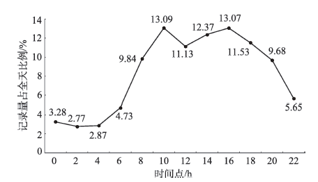
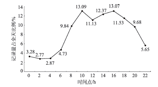
中心城区整体的平日活动曲线如图3所示。可以看出,2-6点时段,作为居民传统的睡眠时间,信令数据记录量最小,其中,2-4点时段和4-6点时段记录量仅占全天总数据规模的2.77%和2.87%,是全天记录量最小的2个时段。6-8点时段数据量开始增加,占一天总体数据规模的比例升至4.73%,表明了居民一天日常活动的开始。之后居民活动逐渐频繁,数据量也快速上升,至10点时段达到最高峰,约占全天记录总量的13.09%。中午12点时段,伴随着居民午餐、午休等活动,记录量有所下降(约占全天11.13%),但之后伴随下午上班开始,记录量又开始回升,在16点时段达到另一个高峰,约占全天记录总量的13.07%。18点时段下班之后,数据量又逐渐回落,但仍然保持着较高比例,说明居民在日常工作、学习后,随着可支配时间的增加以及活动内容的丰富(购物、餐饮、娱乐等休闲活动增多),活动仍较频繁,并持续到22点时段。而22点时段往后到次日凌晨,随着夜间休息时段的到来,数据规模又开始明显的下降。
总体而言,手机数据记录量的日节奏曲线呈现出典型的双峰型曲线,在居民的工作上班时间段达到高峰,休息时段达到低谷,与居民的日常行为规律有着明显的相似性。
3.1.2 时空分布
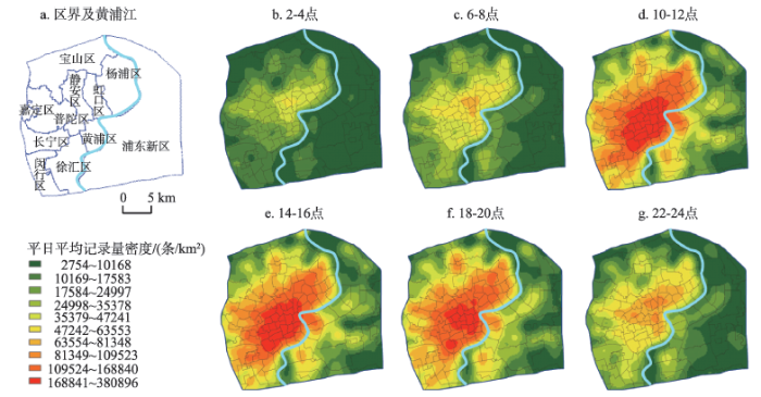
从中心城区日记录强度的空间分布变化来看(以活动强度最大的时间段的分位数为等级划分标准⑦,对所有12个时间段进行统一等级划分,以不同颜色显示,图4展示了其中6个时段的空间分布),也存在较为明显的等级集聚特征。具体可以归纳为以下3个空间特征:首先,记录强度南北差异明显。中心城区北部四区(即虹口区、杨浦区、普陀区和静安区)晚上记录强度较大,以居住为主。而南部四区(即黄浦区、徐汇区、长宁区和浦东新区外环线以内的中心城区部分)则白天记录强度较大,以就业为主。其次,黄浦江两岸差异对比明显。浦西地区整体记录强度明显高于浦东,在浦西内环以内的中心城区核心区,高强度活动空间成片分布,并沿交通廊道带状向外扩散;而浦东地区高强度活动地区则以点状分布为主。最后,中心城区呈现出较为明显的核心—边缘的单中心结构,且核心—边缘差异明显,强度等级差异呈现圈层结构分布。
图4 上海中心城区内人口平日6时段纪录强度变化
Fig.4 Dynamic characteristics of population distribution in the city center of Shanghai
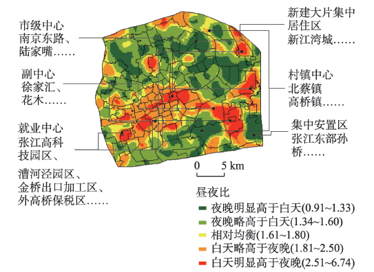
计算昼夜比指标结果如图5所示。中心城区各栅格平均昼夜比为1.71,即白天记录量高于夜晚。空间分布上,主要的昼夜比高值区为全市的核心就业区(如静安寺、南京路、陆家嘴中心)、区域副中心(如大宁路中心、徐家汇中心、花木中心)、经济技术开发区(如漕河泾新兴技术开发区、张江高科技园区)以及进出口加工区(如金桥出口加工区、外高桥保税区)等。因此,上海中心城区空间活动的总体结构为核心区呈T字型就业集中区,加散布的外围就业据点。相反,大片集中居住社区(如浦兴路街道、中原新江湾城、大华居住区、共康新村)、村镇集中居住区(如北蔡镇、高桥镇)、集中安置区(如张江东部),以及老城区,则为主要的昼夜比低值区。
图5 上海中心城区记录强度的昼夜比空间分布
Fig.5 The ratio of records in the city center of Shanghai at daytime and nighttime
3.2.1 活动节奏差异
基于对人群活动规律的通常理解,人群活动很大程度上呈现出以周为单位的周期性变化。但以平日与周末的二日最为典型,据此构建平日和周末的二日周期。对比平日和周末的平均记录量(表1)可以看出,与平日相比,居民在周末的记录数据规模更加集中在晚上,活动节奏与平日相比后移,且在下午时段的分布更加均衡,呈现早上的单峰型曲线。具体来看,从20点-次日6点时段,周末记录量在各时段占比均高于平日。而在白天8-18点时段,数据规模低于平日,仅占总体规模的68.19%(平日约占72.26%)。在周末,下午16点时段不再像平日一样有明显增长,产生下午的记录量高峰,而是在12-18点下午各时段,记录量相对均衡分布。这种变化反映了居民在平日和周末活动节奏的不同。周末曲线峰值的后移,体现了“晚起晚睡”的作息规律。而曲线更加平缓也表明居民周末的日常活动(如购物、餐饮、娱乐等)在时间安排上更加灵活自由,并不像工作日局限于晚上时段,因此活动频度在下午时间分布上相对均衡。
表1 平日周末活动节奏比较
Tab.1 Comparison of record changes between weekdays and weekends
| 时间段 | 平日 | 周末 | |||
|---|---|---|---|---|---|
| 平均记录量/(万条/日) | 占全天比重/% | 平均记录量/(万条/日) | 占全天比重/% | ||
| 0-2点 | 1007.73 | 3.19 | 1032.63 | 4.11 | |
| 2-4点 | 835.54 | 2.64 | 832.24 | 3.31 | |
| 4-6点 | 853.44 | 2.70 | 814.41 | 3.24 | |
| 6-8点 | 1354.93 | 4.28 | 1170.88 | 4.66 | |
| 8-10点 | 2994.38 | 9.46 | 2332.47 | 9.28 | |
| 10-12点 | 4219.40 | 13.34 | 3280.88 | 13.05 | |
| 12-14点 | 3594.96 | 11.36 | 2888.69 | 11.49 | |
| 14-16点 | 4043.63 | 12.78 | 2955.90 | 11.76 | |
| 16-18点 | 4353.91 | 13.76 | 2913.00 | 11.59 | |
| 18-20点 | 3658.56 | 11.56 | 2771.23 | 11.02 | |
| 20-22点 | 2955.58 | 9.34 | 2507.26 | 9.97 | |
| 22-24点 | 1766.10 | 5.58 | 1644.71 | 6.54 | |
| 合计 | 31638.15 | 100.00 | 25144.31 | 100.00 | |
3.2.2 时空分布
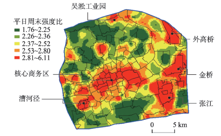
计算平日周末活动强度差异的整体指标,结果如图6所示。中心城区平均平日周末强度比为2.5。空间分布上,主要的昼夜比高值区为内环的核心区,包括静安寺、长寿路、南京西路、南京东路以及陆家嘴中心,高值已连片分布;其次,区域副中心,如大宁路中心、徐家汇中心,以及主要的就业区,如漕河泾新兴技术开发区、张江高科技园区、金桥出口加工区、外高桥保税区等,都是平日周末差异明显的区域,平日活动强度远高于周末。
图6 上海中心城区整体平日周末差异
Fig.6 The ratio of records on weekdays and weekends in the city center of Shanghai
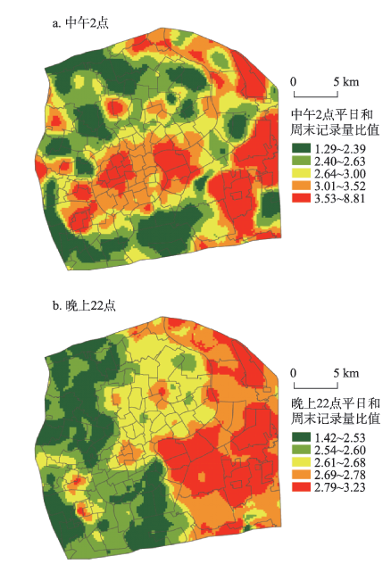
为对比平日和周末不同时段记录量的空间分布差异,本文分别选取了14-16点,以及22-24点两个时段⑧(⑧ 研究以2个小时为时间单元,对一天中的12个时间单元都分别计算了平日记录量和周末记录量的比值进行比较。结果显示,早上10-12点和下午14-16点时段的空间分布较为显示,都呈现出就业中心比值高特征。因此研究选择了以下午时段为代表在文中进行具体阐述。
)代表下午和晚上,分别计算各时段平日记录量和周末记录量的比值(图7)。可以发现,在下午时段,平日周末记录量差异比在空间分布上呈现出就业中心(如静安寺商务区、陆家嘴、漕河泾新兴技术开发区、张江高科技园区、金桥进出口加工区、外高桥保税区等)比值高,这些区域平日和周末伴随着工作人员的流入流出,记录量强度差异明显。而在晚上时段的差异比,与下午时段呈现出较为明显的差异,整体分布格局并非呈现核心—外围区域差异结构,而是浦西和浦东地区比值差异显著。平日周末记录量差值比较大的区域集中分布在浦东地区,且以各集中就业区表现得尤为明显,这也进一步反映了在浦东的稳定居住人口较少,并且夜间的活动场所有限,因此在周末,浦东的夜间活动强度与浦西相比明显不足。
图7 上海中心城区不同时段平日和周末记录量差异比较
Fig.7 Comparison of the ratio of records on weekdays and weekends in two different periods in the city center of Shanghai
在上述对时间维度的上海中心城区空间特征分析结果的基础上,尝试从活动随时间变化的节奏曲线特征角度,对上海中心城区的空间进行划分。
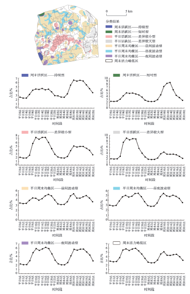
聚类过程在R软件中实现(Bodenhofer et al,2011),结果将中心城区归纳为4个大类8个小类活动区域,并显示了各类空间所对应的典型活动曲线和主要的用地类型⑨(⑨由于土地利用现状(2014年)数据采用的是国家《城市用地分类与规划建设用地标准GBJ137—90》用地分类标准,因此本研究中也使用这一分类标准。)(图8,表2)。
图8 上海中心城区基于二日周期活动曲线的空间聚类及各类典型波形
Fig.8 Spatial clustering based on dynamic characteristics and typical curves in the city center of Shanghai
表2 上海中心城区空间分类结果
Tab.2 Spatial clustering results of the city center of Shanghai
| 周末活跃区 | 平日活跃区 | 平日周末均衡区 | 其他 | 总计 | |||||||
|---|---|---|---|---|---|---|---|---|---|---|---|
| 持续型 | 短时型 | 差异较小型 | 差异较大型 | 昼间波动型 | 昼夜波动型 | 夜间波动型 | |||||
| 特征 | 周末活动强度明显强于平日,且其白天的高强度活动有一定持续性 | 周末活动强度明显强于平日,且其白天的高强度活动只在下午时段出现 | 平日活动强度明显强于周末,且两者差异较小 | 平日活动强度明显强于周末,而两者差异较大 | 平日周末活动均衡,且昼夜波动小,白天波动较大 | 平日周末活动均衡,且昼夜活动强度都有所波动 | 平日周末活动均衡,且夜间强度明显下降,波动 较大 | 周末活动强度有所下降 | |||
| 分布 | 闵行体育公园东侧居住区和市场 | 顾村公园南侧 | 内环内的核心活动区域 | 典型的集中就业区 | 大型居住区 | 功能多样的混合地带 | 集中购物休闲区 | 均衡区和平日活跃区之间 | |||
| 面积/km2 | 6.60 | 2.84 | 57.76 | 56.88 | 271.40 | 85.60 | 21.08 | 176.32 | 678.48 | ||
| 占比/% | 0.97 | 0.42 | 8.51 | 8.38 | 40.00 | 12.62 | 3.11 | 25.09 | 100.00 | ||
| 第一大类用地 | 居住用地 | 非建设用地 | 居住用地 | 工业用地 | 居住用地 | 居住用地 | 居住用地 | 居住用地 | |||
| 用地占比/% | 44.85 | 21.13 | 31.09 | 31.08 | 46.03 | 37.66 | 38.71 | 25.34 | |||
| 第二大类 用地 | 公共设施 用地 | 绿地 | 道路广场 用地 | 公共设施 用地 | 工业用地 | 工业用地 | 公共设施 用地 | 工业用地 | |||
| 用地占比/% | 26.67 | 21.13 | 22.99 | 20.89 | 9.80 | 11.78 | 23.15 | 19.46 | |||
| 第三大类 用地 | 对外交通 用地 | 村镇建设 用地 | 公共设施 用地 | 村镇建设 用地 | 公共设施 用地 | 公共设施 用地 | 绿地 | 公共设施 用地 | |||
| 用地占比/% | 8.48 | 16.90 | 21.33 | 17.86 | 9.20 | 9.91 | 11.01 | 11.86 | |||
(1) 周末活跃区。该空间类型的特征是周末记录量占比明显高于平日,以周末活动为主。其中,根据周末记录变化曲线的不同,又可细分为周末持续型和周末短时型。图8中深蓝色的持续型区域为闵行体育公园的东侧,其周末白天的高活动强度有一定的持续性。从用地上来看,主要是位于公园周边的居住用地(占该类型的44.85%),以九星市场为主的公共设施用地(占比为26.67%),以及8.48%的交通用地。深绿色的短时型区域为顾村公园的南侧,非建设用地和绿地为最主要的用地类型,各占该类型的21.13%;另外,村镇建设用地也占比较高,为16.9%,其周末白天的高强度活动只在下午时段出现。可以看出,周末活跃区主要为公园、公共设施用地等休闲娱乐类空间及周边地区,周末人群活动强度大,但不同地区或类型的休闲娱乐类空间,其活动的持续时间从波形来看有所差异。
(2) 平日活跃区。该空间类型的平日记录量占比明显高于周末,以平日活动为主。红色的差异较小型区域主要为上海的中央核心活动区域,活动内容丰富,因此活动曲线呈现出昼夜差异明显,周末与平日相比有所下降;最主要的3类用地类型为居住用地、道路广场用地以及公共设施是用地。而灰色区域周末记录量与平日相比降低明显,为中心城区典型的集中就业区,包括陆家嘴的核心区、张江高科技园区、外高桥保税区、漕河泾工业园区等,这类空间集聚了大量就业岗位,但相关生活配套较少,因此在周末或夜晚非工作时间段,随着工作人员的离开,数据记录量骤降。从用地构成上来看,也可以发现以工业用地、公共设施用地,以及村镇建设用地等这些集中提供就业岗位的用地类型为主。
(3) 平日周末均衡区。该空间类型的平日和周末的记录量占比较为均衡,活动强度在平日周末之间没有很大的差异,但每日的波形特征有所差异,据此可细分为昼间波动型、昼夜波动型和夜间波动型3种小类空间。其中,橙色表示的昼间波动型,主要集中在大型居住区,如中原社区、曲阳社区、金桥社区、孙桥集镇等,这些区域人群稳定,因此即使晚上时段占比也较高,整个波形一直处在较高的占比水平,在白天的上午10点和下午2点时段左右形成了4个明显的波峰,以白天波动较明显;蓝色的昼夜波动型区域则功能较为混杂多样,没有明显的主导功能,其波形特征也与中心城区整体的波形最为相似;紫色的夜间波动型区域主要与中心城区较为集中的购物休闲区相关,如五角场商圈、大宁路商圈、四川北路、中山公园、真如副中心、锦江乐园等,主要用地类型包括居住、公共设施用地和绿地,这些区域作为中心城区主要的商圈平日周末都人气较旺,但活动都集中在白天时段,因此夜晚活动明显下降,占比降低,昼夜差异较明显。
(4) 其他。该空间类型的特征是周末记录量与平日相比有小幅的下降,程度介于上述平日周末均衡区和平日活跃区之间,因此空间分布上也主要处于这2类空间区域的中间地带。
总体来看,在上海中心城区范围内,大多数区域的活动记录在平日周末较为均衡,越往核心区即内环以内,由于以公共服务、商务办公等功能为主,平日活力逐渐强于周末,平日和周末之间的记录活动差异开始增加。同时,内环以内地区的功能类型丰富混合,内环以外地区则功能区域更加集中和单一。这一特征与用地布局密切相关。上海内环内的核心区各类用地(如公共设施用地、居住用地、公园绿地等)布局混合,使得居民进行各类活动的空间灵活性提升,就业、休闲、居住等功能的空间边界日益模糊,研究的分类结果可大致看出上海中央活动区的空间边界。反观外围地区,各类用地大面积集中(如大型工业区、居住区、大学城),因此分区结果也表现出各类空间点状分散分布的特征,如城市公园为主要的周末活跃型区域,仍保留着居民活动曲线与用地类型的大致相关性,有较为明显的空间分区边界。
在认识空间的动态活动特征后,可结合其活动特征加以规划和管理,如周末活跃区和平日活跃区,其活动强度在平日和周末差异大,可考虑在其活动强度较低时段引入其他功能,如丰富陆家嘴就业区在周末的活动,虹口足球场增加白天时段的活动项目以提高空间全时段的活动效率。对于只有短时人群大量集聚的短时型周末活跃区(如活动集中在周末下午的顾村公园南侧区域),可考虑丰富其活动类型,提高活力的持续性,同时重视做好人群集聚爆发时段的预测预警,加强监控和管理工作。
本文利用手机信令数据,以上海市中心城区为例,进行城市空间活动的周期特征分析和空间划分。研究发现,城市空间活动的两个主要周期特征,即一日周期和二日周期,并分别从活动曲线和时空分布差异进行了探讨。这两大周期特征与人的作息规律相符合,中心城区整体活动重心在一天中呈顺时针变化。市内环内核心区、城市副中心及主要就业中心,昼夜波动和平日周末活动强度的差异都较为明显。进一步,基于空间的周期活动曲线,采用相似性传播聚类算法将上海中心城区划分为4个大类和8个小类的功能区。总体来看,居民活动与空间土地利用的组织是相关的。上海内环以内核心地区的用地混合丰富了区域内的空间功能,使得功能区边界模糊,形成混合活动区。相反,外围地区用地布局集中单一,使得空间活动特征分明且内容同化,活动功能区边界明显。研究表明,一方面,城市空间规划安排的合理性,可由规划的各类场所居民活动强度的变动趋势加以印证;另一方面,由规划带来的基础设施、公共服务设施在一定区域的集中建设投入,也对人们活动的空间选择产生了一定的引导作用。亦即城市活动空间的周期特征既体现了个体活动充分的空间能动性,也反映出居民空间活动对土地使用类型以及设施建设、投入程度的耦合性,呈现出“流动性”和“粘滞性”的双重属性。通过活动空间的特征认识和分类,发现各类居民活动的实际情况与规划的空间利用方式可能存在的差异,对既定土地使用规划的合理性提出质疑,也可为未来规划的修编提供指导,为城市空间结构、功能布置、设施布局等方案提供新的决策支撑。
通过本文研究可以看出,手机信令数据在行为活动的动态分析研究领域,具有重要意义和价值。通过手机信令数据,可以更加便捷、全面、动态、客观地获取高分辨率的人口时空动态分布信息,这是认识城市流动性的重要基础。通过对手机信令数据提供的个人行为反映城市空间的周期活动特征,进而对城市空间进行特征分区,为城市活动空间的评价和优化策略的制定提供了新的思路和依据。当然,本文同时也存在一些不足之处,如数据精度上由基站信号定位产生的无法避免的空间误差,也无法对人群的停留时间、活动目的进行更加细致的分析,空间之间的相互影响以及人群组成上的周期特征也未能进行更为广泛和深入的探讨。随着更多数据的获取和研究的深入,可与其他类型的数据(如反映人的行为数据、物质空间环境数据、天气数据、点评数据等)进行融合,克服单一数据视角的局限,实现对同一空间的多角度、全方位地刻画,建立更为综合的城市空间特征的分析框架,发掘更多更有价值的信息。
The authors have declared that no competing interests exist.
| [1] |
北京居民活动与出行行为时空数据采集与管理 [J].https://doi.org/10.11821/yj2013030006 URL [本文引用: 1] 摘要
The space-time data of individual behavior is one of the most important quantitative foundations of modeling and analyzing in the research of human geography,transportation and urban planning.The development of location-based technologies as well as information and communication technologies(ICT) makes accurate space-time data collection more feasible and affordable.Some unique conditions in China during the transition make it possible to obtain more detailed and reliable data.This study compares individual behavior survey methods and applications based on traditional questionnaires with those based on location-based technologies.It further explores the collection and management of individual space-time data,using the seven-day activity-travel survey in 2010 Beijing as the dataset.The survey methods contain location-aware devices which are a combination of GPS and GSM,interactive survey website including activity diary filling interface for respondents and monitor interface for administrators,and interview on telephone and face to face.Respondents' socio-economic characteristics,one-week space-time trajectories and activity-travel diaries are included in the database.Moreover,the study demonstrates the data problems that were met such as data noise,data loss,problems associated with the algorithm.We attempt to offer theory,method and application experiences of highly accurate data collection and management to research on urban activity-travel system.
The collection and management of space-time data of individual behavior based on location-based technologies: A case study of activity-travel survey in Beijing [J].https://doi.org/10.11821/yj2013030006 URL [本文引用: 1] 摘要
The space-time data of individual behavior is one of the most important quantitative foundations of modeling and analyzing in the research of human geography,transportation and urban planning.The development of location-based technologies as well as information and communication technologies(ICT) makes accurate space-time data collection more feasible and affordable.Some unique conditions in China during the transition make it possible to obtain more detailed and reliable data.This study compares individual behavior survey methods and applications based on traditional questionnaires with those based on location-based technologies.It further explores the collection and management of individual space-time data,using the seven-day activity-travel survey in 2010 Beijing as the dataset.The survey methods contain location-aware devices which are a combination of GPS and GSM,interactive survey website including activity diary filling interface for respondents and monitor interface for administrators,and interview on telephone and face to face.Respondents' socio-economic characteristics,one-week space-time trajectories and activity-travel diaries are included in the database.Moreover,the study demonstrates the data problems that were met such as data noise,data loss,problems associated with the algorithm.We attempt to offer theory,method and application experiences of highly accurate data collection and management to research on urban activity-travel system.
|
| [2] |
基于活动分析法的人类空间行为研究 [J].Acitivity-based approach to human spatial behavior research [J]. |
| [3] |
中国时空间行为研究进展 [J].https://doi.org/10.11820/dlkxjz.2013.09.006 URL [本文引用: 1] 摘要
As a unique perspective for understanding the complex relationships between human activities and urban environments in space and time, the space-time behavior approach has become an influential methodology in China's urban geography since 1990s. Aiming at promoting communications and exchanges among urban geographers in different contexts, this article provides a critical review of space-time behavior research in China. Ever since time geography and activity-based model were introduced to China's urban geography, space-time behavior research in China has benefited from the fruitful theoretical and methodological progress made in Western geographical research. On one hand, GPS and mobile phone tracking technologies have been integrated into activity-diary surveys to collect more accurate and real-time activity-travel information. On the other hand, advanced statistical models and geocomputational and 3D geovisualization methods have been adopted in more recent empirical literature in China. Yet, while Chinese urban geographers have made more methodological progress in data collection and analytic tools thanks to the development of GPS and GIS technology, theoretical development still lags behind. However, space-time behavior research in China, with planning-oriented characteristics, offers a unique framework for understanding urban transformation in China. It has become a new perspective for understanding the complexity and diversity of human behavior patterns in the transitional cities in China. In other words, space-time behavior research tries to describe and interpret urban spatial structures and spatial reconstructing in urban China from the perspective of individuals' behaviors. The impacts of danwei-based urban spatial organization and its disappearance, as well as the impacts of suburbanization on individuals' daily activities, have been studied carefully. Especially, this approach emphazes how spatial restructuring impact individuals' daily life experiences, which in turn are related to the issues such as life quality, social equity and environmental sustainability. Urban geographers in China have begun to apply the space-time activity approach to the socio-spatial issues in the cities by focusing on daily-activity experiences of low SES (socioeconomic status) populations. And the development of the low-carbon city movement in China has prompted the application of the space-time behavior approach in understanding the impacts of land use characteristics on travel-related carbon- dioxide emissions through individuals' travel decisions. At the same time, planning practices based on the space-time behavior approach is carried out in urban transportation, tourism, and urban planning. The space-time behavior approach has become a very useful human-oriented approach to land use and transportation planning in China. The article concludes by discussing key theoretical and practical challenges for future development of space-time activity research in China.
Progress in space-time behavior research in China [J].https://doi.org/10.11820/dlkxjz.2013.09.006 URL [本文引用: 1] 摘要
As a unique perspective for understanding the complex relationships between human activities and urban environments in space and time, the space-time behavior approach has become an influential methodology in China's urban geography since 1990s. Aiming at promoting communications and exchanges among urban geographers in different contexts, this article provides a critical review of space-time behavior research in China. Ever since time geography and activity-based model were introduced to China's urban geography, space-time behavior research in China has benefited from the fruitful theoretical and methodological progress made in Western geographical research. On one hand, GPS and mobile phone tracking technologies have been integrated into activity-diary surveys to collect more accurate and real-time activity-travel information. On the other hand, advanced statistical models and geocomputational and 3D geovisualization methods have been adopted in more recent empirical literature in China. Yet, while Chinese urban geographers have made more methodological progress in data collection and analytic tools thanks to the development of GPS and GIS technology, theoretical development still lags behind. However, space-time behavior research in China, with planning-oriented characteristics, offers a unique framework for understanding urban transformation in China. It has become a new perspective for understanding the complexity and diversity of human behavior patterns in the transitional cities in China. In other words, space-time behavior research tries to describe and interpret urban spatial structures and spatial reconstructing in urban China from the perspective of individuals' behaviors. The impacts of danwei-based urban spatial organization and its disappearance, as well as the impacts of suburbanization on individuals' daily activities, have been studied carefully. Especially, this approach emphazes how spatial restructuring impact individuals' daily life experiences, which in turn are related to the issues such as life quality, social equity and environmental sustainability. Urban geographers in China have begun to apply the space-time activity approach to the socio-spatial issues in the cities by focusing on daily-activity experiences of low SES (socioeconomic status) populations. And the development of the low-carbon city movement in China has prompted the application of the space-time behavior approach in understanding the impacts of land use characteristics on travel-related carbon- dioxide emissions through individuals' travel decisions. At the same time, planning practices based on the space-time behavior approach is carried out in urban transportation, tourism, and urban planning. The space-time behavior approach has become a very useful human-oriented approach to land use and transportation planning in China. The article concludes by discussing key theoretical and practical challenges for future development of space-time activity research in China.
|
| [4] |
时空轨迹聚类方法研究进展 [J].https://doi.org/10.11820/dlkxjz.2011.05.002 URL [本文引用: 1] 摘要
A trajectory is a sequence of the location and timestamp of a moving object. It is not only an important type of spatio-temporal data, but also a critical source of information. Extracting patterns from different trajectory data can help people understand the drives and outcomes of individual and collective spatial dynamics, such as human behavior patterns, transport and logistics, emergency evacuation management, animal behavior, and marketing. Recently, a larger number of trajectory data are available for analyzing the temporal and spatial pattern, as the result of the improvements of tracking facilities and sensor networks. Therefore, clustering analysis needs to be used to find the implicit patterns in it. Based on the characteristics and the similarity measurements of trajectory data, this paper reviewed the research progresses in trajectory clustering methods. Firstly, the significance of research on trajectory data and its clustering methods was presented. Then the definition, models as well as several visualization methods of trajectories were summarized. After that, the authors classified the existing trajectory clustering methods into 6 main categories according to the similarity measurement of them, and analyzed each of the trajectory clustering methods, along with their respective pros and cons by category. Finally, some research challenges and future directions were discussed.
Review of the research progresses in trajectory clustering methods [J].https://doi.org/10.11820/dlkxjz.2011.05.002 URL [本文引用: 1] 摘要
A trajectory is a sequence of the location and timestamp of a moving object. It is not only an important type of spatio-temporal data, but also a critical source of information. Extracting patterns from different trajectory data can help people understand the drives and outcomes of individual and collective spatial dynamics, such as human behavior patterns, transport and logistics, emergency evacuation management, animal behavior, and marketing. Recently, a larger number of trajectory data are available for analyzing the temporal and spatial pattern, as the result of the improvements of tracking facilities and sensor networks. Therefore, clustering analysis needs to be used to find the implicit patterns in it. Based on the characteristics and the similarity measurements of trajectory data, this paper reviewed the research progresses in trajectory clustering methods. Firstly, the significance of research on trajectory data and its clustering methods was presented. Then the definition, models as well as several visualization methods of trajectories were summarized. After that, the authors classified the existing trajectory clustering methods into 6 main categories according to the similarity measurement of them, and analyzed each of the trajectory clustering methods, along with their respective pros and cons by category. Finally, some research challenges and future directions were discussed.
|
| [5] |
智能手机定位数据应用于城市研究的进展与展望 [J].
移动信息时代与大数据时代的到来,促使城市研究方法趋于多元化。随着智能手机出现和手机功能不断发展,手机普及率大大提高,基于位置服务应用的智能手机数据成为最具研究意义的大数据来源之一,为智慧城市建设和城市问题的研究提供了新的思路与方法。本文对该数据特征和以往其应用于城市研究领域的方法进行了总结;结合该数据特征和智慧城市研究领域,从城市居民行为研究、城市空间结构研究、城市生态环境研究和城市管治四个方面介绍了智能手机定位数据在城市研究中的应用。文章的最后对手机定位数据在城市研究中的应用前景进行了探讨,并强调手机定位数据研究应与规划实践相结合。
Progress and prospect of the application of smart phone LBS data in urban researches [J].
移动信息时代与大数据时代的到来,促使城市研究方法趋于多元化。随着智能手机出现和手机功能不断发展,手机普及率大大提高,基于位置服务应用的智能手机数据成为最具研究意义的大数据来源之一,为智慧城市建设和城市问题的研究提供了新的思路与方法。本文对该数据特征和以往其应用于城市研究领域的方法进行了总结;结合该数据特征和智慧城市研究领域,从城市居民行为研究、城市空间结构研究、城市生态环境研究和城市管治四个方面介绍了智能手机定位数据在城市研究中的应用。文章的最后对手机定位数据在城市研究中的应用前景进行了探讨,并强调手机定位数据研究应与规划实践相结合。
|
| [6] |
基于手机数据识别上海中心城的城市空间结构 [J].https://doi.org/10.3969/j.issn.1000-3363.2014.06.009 URL [本文引用: 1] 摘要
以上海中心城为例,提出了利用手机定位数据识别城市空间结构的方法。首先,使用移动通讯基站地理位置数据和手机信令数据,依据基站汇总所连接用户数量,采用核密度分析法生成手机用户密度图,分别计算了上海中心城内工作日10点和23点、休息日15点和23点的多日平均用户密度图。随后,对工作日10点、休息日15点的手机用户密度空间分布进行空间聚类和密度分级,用于识别城市公共中心的等级和职能类型。最后,对工作日、休息日昼夜手机用户密度比值、夜间手机用户密度进行比较,用于识别就业、游憩、居住功能区及其混合程度。
Understanding urban spatial structure of Shanghai central city based on mobile phone data [J].https://doi.org/10.3969/j.issn.1000-3363.2014.06.009 URL [本文引用: 1] 摘要
以上海中心城为例,提出了利用手机定位数据识别城市空间结构的方法。首先,使用移动通讯基站地理位置数据和手机信令数据,依据基站汇总所连接用户数量,采用核密度分析法生成手机用户密度图,分别计算了上海中心城内工作日10点和23点、休息日15点和23点的多日平均用户密度图。随后,对工作日10点、休息日15点的手机用户密度空间分布进行空间聚类和密度分级,用于识别城市公共中心的等级和职能类型。最后,对工作日、休息日昼夜手机用户密度比值、夜间手机用户密度进行比较,用于识别就业、游憩、居住功能区及其混合程度。
|
| [7] |
大数据时代城市时空间行为研究方法 [J].https://doi.org/10.11820/dlkxjz.2013.09.005 URL [本文引用: 1] 摘要
信息技术的快速发展带来了"大数据"时代的到来,改变了城市的空间组织和居民行为,并使得城市时空间行为研究方法面临变革。本文在总结传统城市时空间行为研究方法存在问题的基础上,对影响其变革的数据获取与处理技术进行梳理,重点从居民时空行为、城市空间及城市等级体系3个方面综述了国内外应用大数据进行城市时空间行为研究的最新进展,构建了基于大数据应用的城市时空间行为研究方法框架。本文认为,大数据时代城市时空间行为研究方法的变革主要取决于对反映居民时空行为的网络或移动信息设备数据的挖掘、处理及应用,但是还需要进一步推动相关学科间的交叉与融合,加强社交网站等网络数据在居民时空行为和城市空间研究中的应用,并指导城市规划编制与管理方法的创新。
Methods in urban temporal and spatial behavior research in the Big Data Era [J].https://doi.org/10.11820/dlkxjz.2013.09.005 URL [本文引用: 1] 摘要
信息技术的快速发展带来了"大数据"时代的到来,改变了城市的空间组织和居民行为,并使得城市时空间行为研究方法面临变革。本文在总结传统城市时空间行为研究方法存在问题的基础上,对影响其变革的数据获取与处理技术进行梳理,重点从居民时空行为、城市空间及城市等级体系3个方面综述了国内外应用大数据进行城市时空间行为研究的最新进展,构建了基于大数据应用的城市时空间行为研究方法框架。本文认为,大数据时代城市时空间行为研究方法的变革主要取决于对反映居民时空行为的网络或移动信息设备数据的挖掘、处理及应用,但是还需要进一步推动相关学科间的交叉与融合,加强社交网站等网络数据在居民时空行为和城市空间研究中的应用,并指导城市规划编制与管理方法的创新。
|
| [8] |
基于特征的时间序列聚类方法研究进展 [J].https://doi.org/10.11820/dlkxjz.2012.10.008 URL [本文引用: 1] 摘要
As terabyte time series data pour into the world, more and more attentions have been paid to the technique of analyzing this data. To understand discrepancy between these data, time series clustering methods have been used to divide them into different groups by similarities. Due to high dimension of time series, the traditional clustering methods for static data is not valid for time series clustering problem when they are susceptible to noise, and can hardly define suitable similarity which are prone to a meaningless result. It is also vexatious for many other methods to solve the clustering problem with missing or unequal data. Time series clustering methods based on characteristics could deal with these problems and discover the essential similarities of time series in all directions. According to characteristics of time series, this paper aimed to review the research progress of characteristics-based clustering methods for time series. Firstly, we introduced the definition and classified the different characteristics of time series. Then we reviewed different time series clustering methods based on characteristics and summarized the generality of each method. Finally we discussed some deficiencies of existing methods, and predicted the future of the relative research.
Research progress in time series clustering methods based on characteristics [J].https://doi.org/10.11820/dlkxjz.2012.10.008 URL [本文引用: 1] 摘要
As terabyte time series data pour into the world, more and more attentions have been paid to the technique of analyzing this data. To understand discrepancy between these data, time series clustering methods have been used to divide them into different groups by similarities. Due to high dimension of time series, the traditional clustering methods for static data is not valid for time series clustering problem when they are susceptible to noise, and can hardly define suitable similarity which are prone to a meaningless result. It is also vexatious for many other methods to solve the clustering problem with missing or unequal data. Time series clustering methods based on characteristics could deal with these problems and discover the essential similarities of time series in all directions. According to characteristics of time series, this paper aimed to review the research progress of characteristics-based clustering methods for time series. Firstly, we introduced the definition and classified the different characteristics of time series. Then we reviewed different time series clustering methods based on characteristics and summarized the generality of each method. Finally we discussed some deficiencies of existing methods, and predicted the future of the relative research.
|
| [9] |
基于手机信令数据的上海市不同等级商业中心商圈的比较: 以南京东路、五角场、鞍山路为例 [J].Comparison of retail trade areas of retail centers with different hierarchical levels: A case study of east Nanjing road, Wujiaochang, Anshan road in Shanghai [J]. |
| [10] |
手机信令数据在城市建成环境评价中的应用: 以上海市宝山区为例 [J].The application of cell phone signaling data in the assessment of urban built environment: A case study of Baoshan district in Shanghai [J]. |
| [11] |
广州市多类型商业中心识别与空间模式 [J].https://doi.org/10.18306/dlkxjz.2016.08.005 URL [本文引用: 1] 摘要
不同职能类型商业中心识别对研究城市商业空间结构有重要意义。与传统识别方法相比,大数据的分析更为精确和便捷。本文以广州市核心区59125条城市热点(POI)数据为基础,利用核密度分析、统计分析、最邻近距离分析等方法识别广州市多类型商业中心的边界,探索其商业空间结构与模式。结果表明:1广州市商业结构呈现明显双核集聚式分布,传统的越秀分区与现代的天河分区构成当前广州市商业空间的双中心;2不同类型的商业中心在空间上呈现显著分异,其中城市生活与公共服务中心在越秀区,商务与金融中心在天河区,休闲娱乐中心呈现分散集聚式特征;3广州市商业结构的空间模式是"圈层+组团"式分布,其中,生活、公共服务、商务职能集中分布于内圈层,娱乐休闲职能呈组团状镶嵌于各圈层中。
Identify of the multiple types of commercial center in Guangzhou and its spatial pattern [J].https://doi.org/10.18306/dlkxjz.2016.08.005 URL [本文引用: 1] 摘要
不同职能类型商业中心识别对研究城市商业空间结构有重要意义。与传统识别方法相比,大数据的分析更为精确和便捷。本文以广州市核心区59125条城市热点(POI)数据为基础,利用核密度分析、统计分析、最邻近距离分析等方法识别广州市多类型商业中心的边界,探索其商业空间结构与模式。结果表明:1广州市商业结构呈现明显双核集聚式分布,传统的越秀分区与现代的天河分区构成当前广州市商业空间的双中心;2不同类型的商业中心在空间上呈现显著分异,其中城市生活与公共服务中心在越秀区,商务与金融中心在天河区,休闲娱乐中心呈现分散集聚式特征;3广州市商业结构的空间模式是"圈层+组团"式分布,其中,生活、公共服务、商务职能集中分布于内圈层,娱乐休闲职能呈组团状镶嵌于各圈层中。
|
| [12] |
基于微博数据的北京市热点区域意象感知 [J].https://doi.org/10.18306/dlkxjz.2017.09.006 URL [本文引用: 1] 摘要
"城市意象"研究对城市文化感知、城市管理与规划、旅游资源开发等具有重要意义。近年来,随着智能移动终端和社交媒体的普及,产生了大量城市内包含有文本和地理位置等信息的社交媒体数据,涉及城市的各个区域,为开展城市意象的综合感知研究提供了新的途径。本文以2016年北京市带位置签到的新浪微博数据为例,在空间聚类发现热点区域的基础上,采用词频—逆文件频率(TF-IDF)与文档主题生成模型LDA两类典型的文本分析的方法,挖掘城市不同热点区域的主题,以感知北京市不同热点区域的社会文化功能和人群行为,并在此基础上通过对热点区域高频主题词进行共词聚类分析,深度挖掘北京市的总体意象。研究表明,运用文本挖掘及地理大数据分析的城市意象研究方法,能及时感知人群在城市不同场所的活动、态度、偏好,从而揭示城市的社会文化及功能特征,是对刻画城市物质形态的城市意象五要素模型的重要补充。此外,以北京市热点区域为例的实证研究结果对现实中的城市特色传承与空间品质塑造等有一定的启发意义。
Image perception of Beijing's regional hotspots based on microblog data [J].https://doi.org/10.18306/dlkxjz.2017.09.006 URL [本文引用: 1] 摘要
"城市意象"研究对城市文化感知、城市管理与规划、旅游资源开发等具有重要意义。近年来,随着智能移动终端和社交媒体的普及,产生了大量城市内包含有文本和地理位置等信息的社交媒体数据,涉及城市的各个区域,为开展城市意象的综合感知研究提供了新的途径。本文以2016年北京市带位置签到的新浪微博数据为例,在空间聚类发现热点区域的基础上,采用词频—逆文件频率(TF-IDF)与文档主题生成模型LDA两类典型的文本分析的方法,挖掘城市不同热点区域的主题,以感知北京市不同热点区域的社会文化功能和人群行为,并在此基础上通过对热点区域高频主题词进行共词聚类分析,深度挖掘北京市的总体意象。研究表明,运用文本挖掘及地理大数据分析的城市意象研究方法,能及时感知人群在城市不同场所的活动、态度、偏好,从而揭示城市的社会文化及功能特征,是对刻画城市物质形态的城市意象五要素模型的重要补充。此外,以北京市热点区域为例的实证研究结果对现实中的城市特色传承与空间品质塑造等有一定的启发意义。
|
| [13] |
基于大数据的文化遗产认知分析方法: 以北京旧城中轴线为例 [J].Analyzing perception of cultural heritage sites based on big data: A case study of Beijing Central Axis [J]. |
| [14] |
大数据对人文: 经济地理学研究的促进与局限 [J].https://doi.org/10.11820/dlkxjz.2015.04.002 URL [本文引用: 1] 摘要
大数据技术的诞生不仅快速推动着社会的进步,而且也将科学研究不断引向新的高度。以人类社会经济活动为主要研究对象的人文—经济地理学与当前大数据建设和发展趋势具有高度一致性,大数据的发展对丰富和完善人文—经济地理学势必起到积极的推动作用,同时也对人文—经济地理学的学科思维和研究方法提出了新的挑战。梳理和分析了目前大数据在人文—经济地理学主要研究领域,包括城市内部空间研究、交通与消费行为、社会空间与社会网络研究中的最近进展,以及大数据对参与式研究和决策平台的作用。着重剖析了大数据对人文—经济地理学数据获取,研究思维与范式,研究内容、研究时空尺度与研究目标等方面的促进作用与存在问题,特别是由于大数据自身发展的不完善,在数据收集特别是数据属性方面还存在很大的局限,缺乏理论基础将会使得大数据与实际应用受到很大限制,同时,数据本身也不能替代研究者思维和决策过程。因此,人文—经济地理学者应该科学对待大数据所带来的机遇,弥补和丰富以往发展中的短板,即完善学科数据建设、建立大数据应用较为完善的研究方法体系,促进跨域数据整合和跨域研究,以及推进研究对象和研究目的的转变。
Opportunities and limitations of big data applications to human and economic geography: The state of the art [J].https://doi.org/10.11820/dlkxjz.2015.04.002 URL [本文引用: 1] 摘要
大数据技术的诞生不仅快速推动着社会的进步,而且也将科学研究不断引向新的高度。以人类社会经济活动为主要研究对象的人文—经济地理学与当前大数据建设和发展趋势具有高度一致性,大数据的发展对丰富和完善人文—经济地理学势必起到积极的推动作用,同时也对人文—经济地理学的学科思维和研究方法提出了新的挑战。梳理和分析了目前大数据在人文—经济地理学主要研究领域,包括城市内部空间研究、交通与消费行为、社会空间与社会网络研究中的最近进展,以及大数据对参与式研究和决策平台的作用。着重剖析了大数据对人文—经济地理学数据获取,研究思维与范式,研究内容、研究时空尺度与研究目标等方面的促进作用与存在问题,特别是由于大数据自身发展的不完善,在数据收集特别是数据属性方面还存在很大的局限,缺乏理论基础将会使得大数据与实际应用受到很大限制,同时,数据本身也不能替代研究者思维和决策过程。因此,人文—经济地理学者应该科学对待大数据所带来的机遇,弥补和丰富以往发展中的短板,即完善学科数据建设、建立大数据应用较为完善的研究方法体系,促进跨域数据整合和跨域研究,以及推进研究对象和研究目的的转变。
|
| [15] |
基于微博语义分析的重庆主城区风貌感知评价 [J].Perception and evaluation of cityscape characteristics using semantic analysis on microblog in the main urban area of Chongqing Municipality [J]. |
| [16] |
基于客流特征的北京地铁站点类型识别 [J].https://doi.org/10.18306/dlkxjz.2016.01.014 URL [本文引用: 1] 摘要
地铁站点是城市各种社会经济活动的关键节点,不同类型的地铁站点在城市中的区域条件、交通功能、土地利用类型等方面均存在差异,科学的站点分类有助于了解城市功能分区及评价轨道交通基础设施建设状况.本文基于2013年3月份14天工作日地铁刷卡客流量数据,运用引入客流特征的时间序列聚类方法,对北京市195个地铁站点进行分类.研究表明:①地铁站点客流量存在时空差异,也是城市功能分区时空差异的表现之一.②通过引入客流特征的时间序列方法,将地铁站点分为居住导向型、就业导向型、职住错位型、错位偏居住型、错位偏就业型、混合型、综合型及其他型8种不同类型.③利用地铁站点客流量数据,是将空间行为和实体空间进行关联比较的有效途径.
Classification of subway stations in Beijing based on passenger flow characteristics [J].https://doi.org/10.18306/dlkxjz.2016.01.014 URL [本文引用: 1] 摘要
地铁站点是城市各种社会经济活动的关键节点,不同类型的地铁站点在城市中的区域条件、交通功能、土地利用类型等方面均存在差异,科学的站点分类有助于了解城市功能分区及评价轨道交通基础设施建设状况.本文基于2013年3月份14天工作日地铁刷卡客流量数据,运用引入客流特征的时间序列聚类方法,对北京市195个地铁站点进行分类.研究表明:①地铁站点客流量存在时空差异,也是城市功能分区时空差异的表现之一.②通过引入客流特征的时间序列方法,将地铁站点分为居住导向型、就业导向型、职住错位型、错位偏居住型、错位偏就业型、混合型、综合型及其他型8种不同类型.③利用地铁站点客流量数据,是将空间行为和实体空间进行关联比较的有效途径.
|
| [17] |
北京城市居民消费区位偏好与决策行为分析: 以西城区和海淀中心地区为例 [J].https://doi.org/10.3321/j.issn:0375-5444.2006.10.003 URL [本文引用: 1] 摘要
以居民消费行为与商业区位选择为研究目的,从消费者属性和商业环境双重视角,构建计量经济模型分析居民消费区位偏好和区位决策行为。研究表明,教育程度、职业类型、收入水平、交通出行方式和购物出发点等居民属性特征显著影响着居民消费区位的偏好,居民对区位、商品价格、服务质量、休息场所、配套设施、停车场等商业环境满意度的评价水平明显影响着居民的消费区位决策,但居民对交通条件、商业规模和商业氛围等满意度的评价水平对消费者区位选择决策的影响并不显著。因此,针对不同消费者要开发和建设不同类别的商业区,以满足不同层次居民的消费需求;另外,良好的商业区位、多元化商品价格、高质量服务水平、完善的休息场所和配套设施、充足的停车场设施等是吸引居民消费的重要条件,也应该是商业区环境建设的重点内容。
Study on residents' shopping location preference and shopping location choice: A case on Xicheng and Haidian districts of Beijing [J].https://doi.org/10.3321/j.issn:0375-5444.2006.10.003 URL [本文引用: 1] 摘要
以居民消费行为与商业区位选择为研究目的,从消费者属性和商业环境双重视角,构建计量经济模型分析居民消费区位偏好和区位决策行为。研究表明,教育程度、职业类型、收入水平、交通出行方式和购物出发点等居民属性特征显著影响着居民消费区位的偏好,居民对区位、商品价格、服务质量、休息场所、配套设施、停车场等商业环境满意度的评价水平明显影响着居民的消费区位决策,但居民对交通条件、商业规模和商业氛围等满意度的评价水平对消费者区位选择决策的影响并不显著。因此,针对不同消费者要开发和建设不同类别的商业区,以满足不同层次居民的消费需求;另外,良好的商业区位、多元化商品价格、高质量服务水平、完善的休息场所和配套设施、充足的停车场设施等是吸引居民消费的重要条件,也应该是商业区环境建设的重点内容。
|
| [18] |
基于地理视角的智慧城市规划与建设的理论思考 [J].Smart city planning and construction based on geographic perspectives: Some theoretical thinking [J]. |
| [19] |
上海市人口分布与空间活动的动态特征研究: 基于手机信令数据的探索 [J].https://doi.org/10.11821/dlyj201705013 URL [本文引用: 1] 摘要
对城市人口空间分布的动态把握是了解人口活动规律、认识城市空间结构、配置城市基础设施和公共服务设施及制订城市公共安全应急保障方案的重要依据。由于目前国内缺少系统的人口动态变化统计数据,城市内部层面的人口空间分布和活动的动态特征方面的相关研究难以开展,研究成果较为有限。移动电话是目前普及率最高的通讯终端设备,其用户的动态分布信息可以准确地反应整个城市人口的空间分布与活动的动态特征。利用手机信令数据,以上海市为例,构建“人口—时间—行为”关系的人口空间动态分析框架,分析上海市人口分布和活动的动态特征。结果表明:上海整体人口密度呈单中心的圈层空间分布结构,昼夜空间分布经历“白天向中心集聚、夜晚向郊区分散”的流动过程;人的各类活动(如通勤、消费休闲)会产生人口空间分布的动态变化,职住关系的不匹配和活动对中心的高度依赖使得人口的空间分布不均,形成向心流动模式。消费休闲行为对中心城区的依赖度明显高于就业活动,且集中体现在紧邻中心城区的外围近郊呈圈层分布。
Dynamic characteristics of Shanghai's population distribution using cell phone signaling data [J].https://doi.org/10.11821/dlyj201705013 URL [本文引用: 1] 摘要
对城市人口空间分布的动态把握是了解人口活动规律、认识城市空间结构、配置城市基础设施和公共服务设施及制订城市公共安全应急保障方案的重要依据。由于目前国内缺少系统的人口动态变化统计数据,城市内部层面的人口空间分布和活动的动态特征方面的相关研究难以开展,研究成果较为有限。移动电话是目前普及率最高的通讯终端设备,其用户的动态分布信息可以准确地反应整个城市人口的空间分布与活动的动态特征。利用手机信令数据,以上海市为例,构建“人口—时间—行为”关系的人口空间动态分析框架,分析上海市人口分布和活动的动态特征。结果表明:上海整体人口密度呈单中心的圈层空间分布结构,昼夜空间分布经历“白天向中心集聚、夜晚向郊区分散”的流动过程;人的各类活动(如通勤、消费休闲)会产生人口空间分布的动态变化,职住关系的不匹配和活动对中心的高度依赖使得人口的空间分布不均,形成向心流动模式。消费休闲行为对中心城区的依赖度明显高于就业活动,且集中体现在紧邻中心城区的外围近郊呈圈层分布。
|
| [20] |
南京东路消费者的空间选择行为与回游轨迹 [J].Space choice behavior and multi-stop tracks of consumers in east Nanjing road [J]. |
| [21] |
APCluster: An R package for affinity propagation clustering [J].https://doi.org/10.1093/bioinformatics/btr406 URL PMID: 21737437 Magsci [本文引用: 1] 摘要
Affinity propagation (AP) clustering has recently gained increasing popularity in bioinformatics. AP clustering has the advantage that it allows for determining typical cluster members, the so-called exemplars. We provide an R implementation of this promising new clustering technique to account for the ubiquity of R in bioinformatics. This article introduces the package and presents an application from structural biology.The R package apcluster is available via CRAN-The Comprehensive R Archive Network: http://cran.r-project.org/web/packages/apclusterapcluster@bioinf.jku.at; bodenhofer@bioinf.jku.at.
|
| [22] |
Real-time urban monitoring using cell phones: A case study in Rome [J].https://doi.org/10.1109/TITS.2010.2074196 URL Magsci [本文引用: 1] 摘要
This paper describes a new real-time urban monitoring system. The system uses the Localizing and Handling Network Event Systems (LocHNESs) platform developed by Telecom Italia for the real-time evaluation of urban dynamics based on the anonymous monitoring of mobile cellular networks. In addition, data are supplemented based on the instantaneous positioning of buses and taxis to provide information about urban mobility in real time, ranging from traffic conditions to the movements of pedestrians throughout the city. This system was exhibited at the Tenth International Architecture Exhibition of the Venice Biennale. It marks the unprecedented monitoring of a large urban area, which covered most of the city of Rome, in real time using a variety of sensing systems and will hopefully open the way to a new paradigm of understanding and optimizing urban dynamics.
|
| [23] |
Eigenplaces: Segmenting space through digital signatures [J].https://doi.org/10.1109/MPRV.2009.62 URL [本文引用: 1] 摘要
Researchers use eigendecomposition to leverage MIT's Wi-Fi network activity data and analyze to the physical environment. We proposed a method to analyze and categorize wireless access points based on common usage characteristics that reflect real-world, placed-based behaviors. It uses eigendecomposition to study the Wi-Fi network at the Massahusetts Institute of Technology (MIT), correlating data generated as a byproduct of network activity with the physical environment. Our approach provides an instant survey of building use across the entire campus at a surprisingly fine-grained level. The resulting eigenplaces have implications for reseach across a range of wireless technology as well as potential applications in network planning, traffic and tourism management, and even marketing.
|
| [24] |
Urban population densities [J]. |
| [25] |
Clustering by passing messages between data points [J].https://doi.org/10.1126/science.1136800 URL PMID: 17218491 [本文引用: 1] 摘要
Clustering data by identifying a subset of representative examples is important for processing sensory signals and detecting patterns in data. Such "exemplars" can be found by randomly choosing an initial subset of data points and then iteratively refining it, but this works well only if that initial choice is close to a good solution. We devised a method called "affinity propagation," which takes as input measures of similarity between pairs of data points. Real-valued messages are exchanged between data points until a high-quality set of exemplars and corresponding clusters gradually emerges. We used affinity propagation to cluster images of faces, detect genes in microarray data, identify representative sentences in this manuscript, and identify cities that are efficiently accessed by airline travel. Affinity propagation found clusters with much lower error than other methods, and it did so in less than one-hundredth the amount of time.
|
| [26] |
|
| [27] |
What about people in regional science? [J]. |
| [28] |
Moving and calling: Mobile phone data quality measurements and spatiotemporal uncertainty in human mobility studies [M] |
| [29] |
Social sensing: A new approach to understanding our socioeconomic environments [J].https://doi.org/10.1080/00045608.2015.1018773 URL [本文引用: 1] 摘要
The emergence of big data brings new opportunities for us to understand our socioeconomic environments. We use the term social sensing for such individual-level big geospatial data and the associated analysis methods. The word sensing suggests two natures of the data. First, they can be viewed as the analogue and complement of remote sensing, as big data can capture well socioeconomic features while conventional remote sensing data do not have such privilege. Second, in social sensing data, each individual plays the role of a sensor. This article conceptually bridges social sensing with remote sensing and points out the major issues when applying social sensing data and associated analytics. We also suggest that social sensing data contain rich information about spatial interactions and place semantics, which go beyond the scope of traditional remote sensing data. In the coming big data era, GIScientists should investigate theories in using social sensing data, such as data representativeness and quality, and develop new tools to deal with social sensing data.
|
| [30] |
A new insight into land use classification based on aggregated mobile phone data [J].https://doi.org/10.1080/13658816.2014.913794 URL Magsci [本文引用: 2] 摘要
Land-use classification is essential for urban planning. Urban land-use types can be differentiated either by their physical characteristics (such as reflectivity and texture) or social functions. Remote sensing techniques have been recognized as a vital method for urban land-use classification because of their ability to capture the physical characteristics of land use. Although significant progress has been achieved in remote sensing methods designed for urban land-use classification, most techniques focus on physical characteristics, whereas knowledge of social functions is not adequately used. Owing to the wide usage of mobile phones, the activities of residents, which can be retrieved from the mobile phone data, can be determined in order to indicate the social function of land use. This could bring about the opportunity to derive land-use information from mobile phone data. To verify the application of this new data source to urban land-use classification, we first construct a vector of aggregated mobile phone data to characterize land-use types. This vector is composed of two aspects: the normalized hourly call volume and the total call volume. A semi-supervised fuzzy c-means clustering approach is then applied to infer the land-use types. The method is validated using mobile phone data collected in Singapore. Land use is determined with a detection rate of 58.03%. An analysis of the land-use classification results shows that the detection rate decreases as the heterogeneity of land use increases, and increases as the density of cell phone towers increases.
|
| [31] |
Cellular census: Explorations in urban data collection [J].https://doi.org/10.1109/MPRV.2007.53 URL [本文引用: 1] 摘要
Cellular networks hold out the promise of a continuously updated locational data stream for a very large sample of a city
|
| [32] |
Adaptive non-parametric identification of dense areas using cell phone records for urban analysis [J].https://doi.org/10.1016/j.engappai.2012.05.005 Magsci [本文引用: 1] 摘要
Pervasive large-scale infrastructures (like GPS, WLAN networks or cell-phone networks) generate large datasets containing human behavior information. One of the applications that can benefit from this data is the study of urban environments. In this context, one of the main problems is the detection of dense areas, i.e., areas with a high density of individuals within a specific geographical region and time period. Nevertheless, the techniques used so far face an important limitation: the definition of dense area is not adaptive and as a result the areas identified are related to a threshold applied over the density of individuals, which usually implies that dense areas are mainly identified in downtowns. In this paper, we propose a novel technique, called AdaptiveDAD, to detect dense areas that adaptively define the concept of density using the infrastructure provided by a cell phone network. We evaluate and validate our approach with a real dataset containing the Call Detail Records (CDR) of fifteen million individuals. (C) 2012 Elsevier Ltd. All rights reserved.
|
| [33] |
Explorations into urban mobility patterns using aggregate mobile network data[R] . |
| [34] |
Trajectory reconstruction from mobile positioning data using cell-to-cell travel time information [J]. |
| [35] |
Understanding spatiotemporal patterns of human convergence and divergence using mobile phone location data [J]. |

/
| 〈 |
|
〉 |