李弘毅 , 刘永学, 张思宇
LI Hongyi, LIU Yongxue, ZHANG Siyu
通讯作者:
收稿日期: 2016-10-9
修回日期: 2017-05-31
网络出版日期: 2018-11-28
版权声明: 2018 地理科学进展 《地理科学进展》杂志 版权所有
基金资助:
作者简介:
作者简介:李弘毅(1992-),女,江苏南京人,硕士研究生,研究方向为海洋遥感与GIS,E-mail: lu_leftright@sina.com。
展开
摘要
面积辽阔的南海是中国未来重要的能源接续区与资源基地,也是涉及国家海洋权益最为集中的区域。本文针对地理信息技术支撑下的南海岛礁研究现状,从南海岛礁现有基础数据成果、遥感手段岛礁基础地理信息提取方法及提取成果所做的岛礁分析与评价3方面,系统地回顾了国内外涉及南海岛礁资源环境研究的相关进展,评述了现有研究技术方法存在的不足,并对未来的研究进行了展望,在此基础上,提出了3个主要方向作为未来研究的重点:①促进遥感数据获取多源化,构建海量多源、多尺度南海岛礁遥感数据仓库;②加强技术协同创新,结合地理信息技术的发展,提升岛礁信息提取与监测的准确性与可靠性;③提升遥感分析智能化,研究并建立综合分析与情势推演平台及战略决策辅助支撑系统,以期为南海岛礁的进一步深入研究提供参考。
关键词:
Abstract
The South China Sea region is an important prospective energy supply area and a resource base for China. Although coral reef resources are extremely abundant in the South China Sea, research on coral reef data extraction, and analysis and evaluation of coral reef resources have not attracted enough attention. This article put forward an analytical framework based on the application of geographic information technologies in the South China Sea, and reviewed the main progresses in three aspects: current availability of basic geographic data, methods on the extraction of basic geographic information, and evaluation of coral reefs in the Siuth China Sea. Based on the review and analysis, this article proposed three research directions in the future: (1) promote multi-source remote sensing data acquisition, build massive remote sensing databases; (2) strengthen collaborative technological innovation, improve the accuracy and reliability of information extraction and monitoring results; and (3) promote intelligent remote sensing analysis, establish comprehensive analysis and decision-support systems which will provide theoretical reference for the further development of coral reef research in the South China Sea.
Keywords:
南海占中国海洋国土的2/3,蕴藏有丰富的石油、天然气、可燃冰及其他矿产和生物等资源(Trung et al, 2012),是未来重要的资源基地与能源接续区(Liu et al, 2011),是国家安全的天然屏障和重要的出海口与战略通道,也是地缘政治经济问题的多发区。作为连接印度洋和太平洋的重要交通要道——全世界的一半以上超级油轮航行于南海海域(Rosenberg et al, 2008),是中国、日本、韩国等国家的“海上生命线”(Wang et al, 2014)。
南海丰富的珊瑚岛礁资源,是中国开发、利用、保护与管控海洋的重要支点(周旻曦等, 2015),战略价值巨大。然而,南海海域岛礁正面临着巨大的环境压力,主要表现为渔业资源数量急剧下降,珊瑚礁盗采严重影响礁盘生长,沙岛面临海浪侵蚀威胁等。在目前的情势下,深入调查、准确获取、客观评价南海珊瑚岛礁自然资源,是地理国情监测的重要组成部分,对保护海洋环境、开发南海岛屿、保障国家战略安全、满足国家在南海的重大战略需求、维护国家权益等具有重要意义(汪业成等, 2013)。
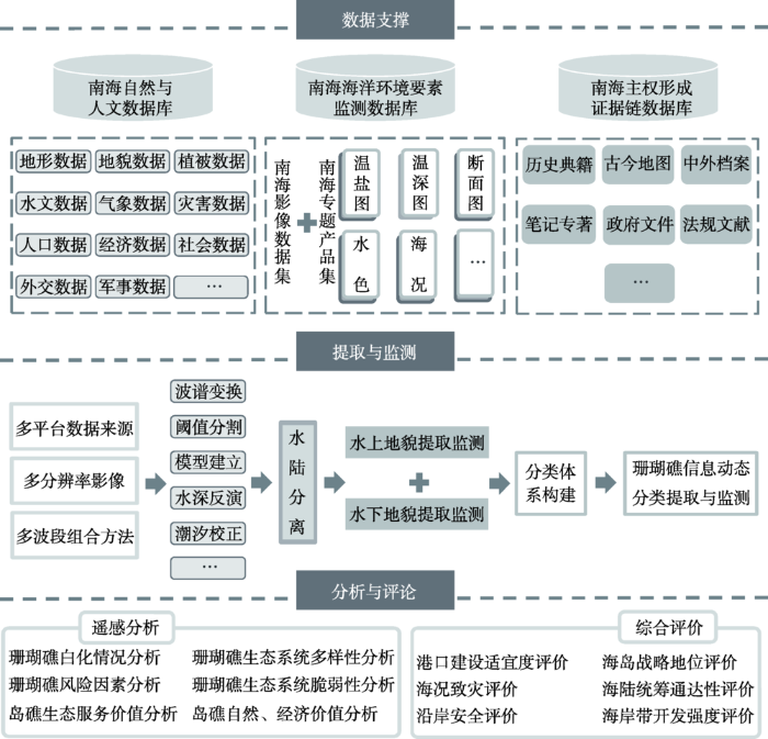
然而,目前南海珊瑚岛礁研究存在基础数据匮乏、动态监测体系缺失、专题定量评价处于定性阶段以及决策支持手段落后等问题,且由于研究涉及多学科、多目标,还面临数据整合难、遥感监测难、决策支持难等诸多技术难题与挑战。地理信息技术,包括地理信息系统(GIS)、遥感(RS)、全球定位系统(GPS)和数字地球技术等,更新了传统的数据获取方式,提供了海量动态的地理空间数据,并实现了海量数据管理与分享以及空间分析功能,革新了大时间跨度、大空间尺度对象的重复监测模式,目前地理信息技术已经在自然资源管理、环境规划与评价、土地管理等方面得到了广泛的应用。基于此,本文对地理信息技术支撑下的南海岛礁资源环境数据调查成果以及相关研究现状进行梳理,从南海资源环境数据调查成果到南海岛礁信息遥感提取手段,再到围绕数据获取结果进行岛礁评价分析的研究现状,总体得出目前南海岛礁资源环境研究现状(图1),最后基于现有研究的不足,提出未来研究应把握的重点,旨在为地理信息技术支撑下的南海岛礁提取、分析与评价等相关岛礁分析研究和实践提供一定的借鉴,以期为国家的南海资源能源开发、海洋权益维护和区域和平发展等提供辅助决策依据。
图1 地理信息技术支撑下的南海岛礁研究主要成果梳理
Fig.1 Achievements based on the application of geographic information technologies in the South China Sea
中国对南海海洋科学考察始于20世纪50年代,1958-1960年“全国海洋普查”共获得各种资料报表和原始记录9.2万多份,各类海洋要素平面分布图、垂直分布图、断面图、周日变化图、温盐曲线图、温深记录图等7万多幅,以及丰富的海洋沉积物样品和大量的标本,编绘了包括南海在内的海底地形等海洋综合调查图集;70年代,对西沙和中沙海域进行了岛礁生物及珊瑚礁地质、地貌专门考察;而对南沙海域的大规模综合科学考察始于80年代,通过在南沙群岛海区进行的3个航次的海洋学综合科学考察,取得了大量的海底地形、地貌等方面的第一手资料。然而,南海珊瑚岛礁数量众多,分布零散,不仅其地貌结构复杂、空间异质性也较强(Webb et al, 2010),并且由于珊瑚岛礁地貌在强风浪场、潮位时变、造礁生物等诸多因素的影响下表现出较高的动态性(Andréfouët et al, 2002),加之受天气、海面状况及南海周边局势等因素影响,实地调查工作开展困难,导致南沙群岛岛礁信息更新困难。所以尽管中国开展了大规模的南海科考活动,意义重大,影响深远,为早期的南海研究搭建起基础数据平台,但是数据获取手段局限、成本消耗巨大、数据获取时间周期过长等仍成为当时南海岛礁研究的瓶颈。
卫星遥感技术作为大面积、实时的全球观测技术,能有效地克服传统地面调查因外界因素而无法实时动态大面积更新的限制,是开展南海珊瑚岛礁地貌专题制图和南海岛礁空间信息获取的新手段,并且已被广泛应用于全球典型珊瑚礁的信息提取与地貌分类。基于多平台、多光谱分辨率、空间分辨率的遥感数据已经证明了其对于珊瑚岛礁信息提取与监测的适用性和有效性(Andréfouët et al, 2003)。
2.2.1 南海岛礁基础地理信息提取
在岛礁信息提取算法方面,岛礁监测效果取决于传感器的平台(星载、机载、船载等)类型、时间/空间/光谱分辨率、大气清晰度、海水表面粗糙度、水深以及水的清晰度等等(Andréfouët et al, 2002; Hochberg et al, 2003; Kutser et al, 2003; Goodman et al, 2007; Roelfsema et al, 2010; Botha et al, 2013)。高空间分辨率遥感影像(IKONOS/SPOT5/QUICKBIRD等)在岛礁详细准确信息监测及地貌分类上已被证明优于中等空间分辨率影像(Mumby et al, 2002; Benfield et al, 2007),并且针对全球范围内大量的珊瑚礁开展了案例研究(Hsu et al, 2008)。但是,相较于传感器平台,岛礁信息遥感提取对于提取方法更加敏感,并且针对不同的珊瑚礁类型一般对应特定的提取方法,主要包括基于纹理/统计等光谱信息的监督/非监督分类方法、结合辅助信息的面向对象分类、自底向上的图像分类方法等,从而能有效地监测岛礁地貌变化。Yamano等(2006)基于多种分辨率遥感影像提取马绍尔群岛南部珊瑚礁水边线。邹亚荣等(2006)利用高分辨多光谱QuickBird影像,基于珊瑚礁几何参数与发育指数对南沙典型岛礁发育进行遥感监测,在珊瑚礁体迎风面水域由破波形成的纹理特征表明了海面粗糙度与水下礁坪的发育特性。陈建裕等(2007)研究了SP0T5数据对东沙环礁珊瑚礁遥感的可行性,指出SP0T5数据由于在光谱设置的缺陷不利于珊瑚礁信息的提取;在潟湖内珊瑚礁的信息提取上,SP0T5数据提取的能力高于ETM+数据。胡蕾秋(2010)等使用SPOT5 10 m多光谱数据对南沙群岛中弹丸礁和光星礁进行了分类实验,并以QuickBird融合影像判读结果及岛礁调查资料为参考,探讨了SPOT5对珊瑚礁水下信息的辨识能力。周旻曦等(2015)提出了双尺度转化下模型与数据混合驱动的遥感地貌信息提取框架,在西沙群岛永乐环礁得到了较好的岛礁信息分类提取结果。Duan等(2016)利用Landsat-8 OLI影像对南沙群岛区域开展了遥感调查与动态监测,发现了4座在《我国南海诸岛部分标准地名》中未命名的岛礁。
尽管目前已开展大量的研究,但珊瑚岛礁遥感信息精确提取仍依赖于人工目视解译和监督分类;并且由于珊瑚岛礁底质差异大、地貌地物分异广等因素,现有研究大多利用中高分遥感影像针对典型单独岛礁进行解译。岛礁信息提取与监测面临岛礁对象单一、数据成本高、人工依赖程度高、自动化水平低且算法可移植性、可拓展性差等问题,因此改善并优化岛礁信息提取算法,利用遥感手段进行大范围珊瑚礁调查、快速了解南沙群岛岛礁情况是亟待解决的问题。
在岛礁水深反演方面,南海海域水深多在1000 m以上,但在岛礁分布区水深变化剧烈,在礁体边缘可由千米水深海盆变为几米水深礁坪(石伟等, 2014),且由于南海岛礁礁盘水深较浅,风浪、底质条件变化快,船只测量难度大,又受限于他国对岛礁的侵占,难以抵近开展实地水深测量,由于岛礁周边水深数据的缺乏,南海商船货轮搁浅事件时有发生,2012年7月11日中国海军一艘护卫舰也意外在半月礁(南沙群岛)附近搁浅,由此可见,开展南海岛礁周边水深遥感反演研究势在必行。党福星等(2003)基于永暑礁(南沙群岛)TM影像,分区地质类型,建立了南海岛礁的浅水深反演模型。盛琳等(2015)基于Worldview-2影像改进非线性模型对东岛(西沙群岛)进行了水深反演。张靖宇(2015)融合多源、多角度、多时相遥感反演模型,在北岛(西沙群岛)水深反演得到了较好的应用。尽管如此,面对整个南海海域200余个岛礁遥感水深反演的迫切需求,现有研究的广度和方法可扩展性都难以满足应用需求。南海岛礁周边水深遥感反演面临着数据匮乏、现存数据分辨率粗、信度和效度低等问题,严重制约着岛礁信息提取、分析与评价等方面的应用,是中国学者需要迫切关注的南海岛礁问题之一。
2.2.2 南海岛礁基础地理信息监测
珊瑚礁生态系统是全球最具有生产力的生态系统之一。近年来全球变暖以及海洋酸化等环境因素极大地威胁着珊瑚礁系统的多样性(Hoegh-Guldberg et al, 2007; Knudby et al, 2007; Maina et al, 2008),由于人类活动的影响常造成大面积珊瑚礁白化现象(Baker et al, 2008) ,美国国家海洋和大气管理局已开展全球珊瑚礁观测项目,使用遥感方法监测珊瑚礁在热应力下的反应((Strong et al, 2011)。就南海及其周边区域而言,东南亚88%的珊瑚礁受到破坏性捕鱼、过渡捕捞、海洋污染、沿海开发等人类活动的威胁;大规模的珊瑚礁退化危机可能对区域粮食安全、生物多样性、沿海渔业等造成数十亿美元的经济损失(Burke et al, 2006),因此珊瑚礁生态系统遥感监测极具迫切性和必要性。
南海海域珊瑚礁面积约8.0×10³ km2,对南海海洋生物多样性、海洋资源维护具有不可或缺的作用。长期遥感监测表明,永兴岛(西沙群岛)在1980-2008年活珊瑚覆盖率从90%降至10%(Yu, 2012)。通过监测美济礁和渚碧礁(南沙群岛)珊瑚共生黄藻显著减少研究表明,美济礁有大量的白化现象(Li et al, 2011)。1997-2010年期间涠洲岛(南海北部)珊瑚骨架在极端温度变化压力下生长速率降低了26%(Chen et al, 2013)。除了自然环境变化导致的珊瑚礁生态环境退化,南海海域开始兴起的大规模岛礁扩建、填海造岛活动也会对珊瑚礁生长以及环境可持续造成一定的负面生态影响,目前南海已有多个岛礁建成机场,其他人类居住等建筑亦在岛上兴建,通过高分影像可以清楚地监测到南海岛礁的开发现状。
南海海域共有已定名岛礁287个,然而目前面向南海海域珊瑚礁生态环境退化的研究仍然较少,受限于岛礁主权争端影响与南海周边各岛礁声索国的军事控制,部分岛礁难以进行定期更新的珊瑚礁现状科学调查,所以针对南海岛礁白化情况或活珊瑚覆盖率等的岛礁生态环境遥感监测仍局限于极个别重点岛礁,大量的南海海域珊瑚岛礁白化情况存在数据空白和资料缺失,对珊瑚礁各资源环境要素的进一步动态监测更是无从谈起,因此,加强南海全海域尤其是地处争端核心区的南沙群岛珊瑚岛礁的遥感监测具有迫切性和重要性,南海海域的岛礁健康监测与脆弱性分析仍处于起步阶段。
可以预见的是,全球气候变化持续加剧、海洋温度变化趋势将会加速珊瑚礁的减少(Hoegh-Guldberg, 2007);并且未来南海周边区域海洋水产养殖和海岸管理依旧会扩张,其带来潜在过渡捕捞和海洋污染等因素亦会对南海珊瑚礁生态系统带来负面影响。南海珊瑚礁面临着气候变化和人类活动共同作用的巨大挑战。因此,对未来南海岛礁及其周边环境遥感分析研究提出了更高的要求,需要在南海岛礁地貌提取与监测的基础上,针对珊瑚礁对环境变化的响应情况进行遥感分析,有效预测珊瑚礁在环境变化与人为活动双重压力下的变化情况,辅助南海珊瑚礁资源保护与岛礁合理开发利用。
南海多数珊瑚礁都表现出共有的、独特的地貌分层分带模式,通常是珊瑚礁发育的结果。典型的地貌区域分带按深度变化包括礁前、礁坪、礁后、澙湖、点礁等(Mumby et al, 2004),然而不同类型的珊瑚礁所依据的地貌分类体系又差异巨大。
在岛礁分类体系方面,何宇华等(1998)选用通过卫星遥感技术获取的航天遥感数据TM-CCT作为主要遥感信息源,并辅以航空遥感资料,开展了南沙群岛重点岛、礁、滩的定位工作。潘春梅等(2002)根据南沙海区的地形地貌特征,利用TM图像,对不同的珊瑚礁、珊瑚沙发育状况和岛礁的地质特征与生态特征进行了分析,研究了水下礁、滩的物质组份、发育程度及TM影像特征,提出了30 m以浅岛礁分类方法,查清了南沙海域岛、礁、滩、沙的形态和分布,细化并完善了南沙群岛岛礁分类。纵观国内外岛礁地貌体系分类方法,国内外学者利用遥感技术已展开了大量的工作,完成了系列珊瑚岛礁专题制图并基于此构建了基于特定规则的分类体系。
但是,由于岛礁地质环境、发育形态的差异,多数研究采用的分类体系分异较大,存在一定的主观性,尚未形成完整统一的珊瑚岛礁分类体系。导致不同研究之间数据缺乏可比性,同时阻碍了数据共享。因此,建立完整的、符合珊瑚礁生态特点的、易于光学传感器监测的地貌分类体系是亟需解决的问题之一。
南海海域珊瑚礁蕴藏着丰富的资源,同时也是最易受到气候变化影响的脆弱生态系统(Graham et al, 2008)。珊瑚礁遥感评价研究国外学者多集中于使用地理信息技术进行珊瑚礁生态价值评价、生态系统的脆弱性评估、珊瑚礁风险评估(Burke et al, 2006)、珊瑚礁危害因素定级等研究(Burke et al, 2006)。近年来,面向维护国家海洋权益的需求,国内诸多学者在地理信息技术的支撑下,适时开展了南海岛礁价值评价、战略地位评价、海陆统筹通达性评价,以及岛礁周边海岸带开发强度评价、港口建设适宜度评价、海况致灾评价、沿岸安全评价等研究。
在岛礁价值评价方面,在多源遥感影像岛礁信息提取基础上,发展了海岛价值分类体系(陈韶阳, 2011; 张荷霞, 2014),针对海岛的自然资源价值、经济价值和生态服务价值方面进行了评价。其中包括南海海域风能资源(Zheng et al, 2011; 蒋洁等, 2014a)、油气资源(张荷霞等, 2013a)等;此外,考虑到南海主权争端情况,进行了越南非法占据岛礁的战略价值评价(唐盟, 2015; 赵赛帅等, 2015)与大量的南沙群岛岛礁的战略地位评价(成王玉等, 2013; 张荷霞, 刘永学等, 2014)。
南沙群岛的周边环境分析评价研究亦是现有研究热点。石伟等(2014)使用地理信息空间分析的方法针对南沙岛礁及其周边港口的可达性进行了评价模型研究;Wang等(2014)基于志愿者观测船(VOS)数据,在地理空间分析的辅助下使用模糊综合评价法进行了南海航道安全评价。针对南海海域风浪潮时变环境,进行了海面风浪场特征分析,并评价了近几十年来热带风暴对南海岛礁的影响(张荷霞等, 2013b; 孙超等, 2014),弥补了海况致灾对岛礁影响评价的缺失。Barnes等(2016)利用时间序列MODIS数据计算浑浊度指数评价了岛礁建设产生的环境影响。
纵观国内外珊瑚岛礁评价研究,目前仅有少量针对南海海域部分珊瑚礁开展的生态系统风险评估(廖彬彬, 2013),因此,对南海岛礁的珊瑚礁生态系统评价、生态服务价值状况应给予更多的关注。另外,现有评价多针对单个岛礁,尚未建立起综合生态、地理、海洋、气候与人类影响的评价模型,对南海岛礁珊瑚礁保护、南海决策分析提供有力的辅助依据,故需要协同数据与评估结果建立丰富的评价模型库群,以期为南海海域资源保护与合理开发提供决策支持。
在评价方法方面,最常使用的是层次分析法、模糊综合评价法和生态和环境空间量值法等(陈韶阳, 2011)。层次分析法能将定性与定量相结合,层次清晰,具有系统化的特点,但是一般通过专家打分等方式确定权重,主观性较强。模糊综合评价法指标清晰明确,计算简便,可以把定性评价转化为定量评价,有利于对一些难以定量判别的不确定因素进行评价。SAVEE(Spatial Appraisal and Valuation of Environment and Ecosystems)方法可针对生态系统和环境空间等地理单元对象,借助地理信息系统对数据进行定量化处理,最终得出定量化、可视化的评价结果。现有南海岛礁及其周边环境评价研究中,其评价方法、评价模型构建过程中,受到主观认知或评价因素不足等限制,从而对不同因子的权重估计有误差,降低了评价结果的精度。因此,未来研究需进一步规范评价指标体系,对南海岛礁时空过程进行统一建模,完善多因素多因子综合评价模型,以更加全面、准确地对南沙岛礁及其周边环境进行遥感评价,为国家制定海洋发展战略、区域行动计划提供辅助决策支持。
地理信息技术的发展,已经在珊瑚岛礁遥感分析方面发挥着不可忽视的作用,全球气候变化和人类活动影响下的南海海域岛礁遥感研究是亟需解决的科学问题,地理信息技术是南海岛礁弥补缺失数据、增强理论研究和分析平台建设等问题的必由手段。目前基于遥感技术的岛礁信息提取、监测与综合评价分析主要受数据积累薄弱、岛礁地貌单元信息分类复杂、岛礁信息提取技术鲁棒性不足以及岛礁评价指标体系不够完善等方面的限制。针对上述基本问题,在地理信息技术支撑下,南海岛礁及其周边遥感分析有望从以下几个方面进一步发展。
考虑到南海岛礁分布零散,尺度范围差异大及南海海域珊瑚礁系统的复杂性,针对不同尺度的南海岛礁信息提取与分析,需要结合多源多尺度的光学、雷达、声学等多类型遥感数据,构建南海及其周边地区全覆盖、时空基准相对一致的遥感数据仓库,增强数据的更新频率,以进一步提升遥感数据的信度和效度。与此同时,针对遥感数据的多维动态特性,设计多粒度、多层次、异构的多源多格式数据集成平台,构建海洋遥感数据标准及规范,设计高效的数据目录体系结构,实现网格环境下的长时间序列、多尺度的南海岛礁遥感数据无缝集成。
(1) 加强数据协同管理,构建南海岛礁资源环境地理信息系统,在地理信息技术的支撑下,将南海岛礁及周边国家和地区的地形地貌信息库、资源能源信息库、气象水文数据库、主权证据链数据库等信息进行充分的史地结合、文理结合以及多学科数据协同,以三维可视化等技术加以表现,构建南海及其周边资源环境的历史地理信息系统。
(2) 融合新兴技术方法,提升岛礁信息监测与提取的准确性与可靠性应同步开展。随着地理信息技术的快速发展,结合无人机航拍摄影技术等新兴领域,岛礁资源环境的监测手段将快速发展,数据可靠性有望大大提升;在大量可靠数据的样本训练下,革新岛礁资源环境信息提取的算法,为未来岛礁信息的高精度分类提取监测提供可能。
南海海洋环境时变、岛礁底质异构,不同的珊瑚礁其地貌和基底类型差异显著,因此构建适用于多平台、多尺度的岛礁地貌分类系统是实现南海岛礁遥感监测的重要基础步骤。岛礁地貌分类系统构建需要注意:① 突破底质异构、潮位时变等复杂环境下的岛礁遥感分类关键技术;② 充分考虑地貌分类的地理学、生态学意义;③ 地貌分类系统可高度适用于已有多平台传感器设置和多尺度数据源特点;④ 地貌分类系统具有科学性和可操作性。在适用于多平台、多尺度的遥感监测的南海珊瑚岛礁地貌分类体系之上,南海岛礁信息提取需建立从栅格数据到多元特征空间再到类别和目标的智能化处理方法,实现集光谱/空间特征于一体的影像分割算法、多特征提取与表达方法以及有效的信息耦合机制,实行进一步的南海海域岛礁遥感动态监测及智能化综合分析,构建岛礁监测情势推演平台。
面对南海岛礁及其周边环境分析评价的个体化、多样化的问题,开展全方位、多维度分析,构建南海岛礁分析评价模型库群,同时进行评价方法定量化描述的改进和优化,针对南海岛礁时空过程进行统一建模,综合自然、经济、政治、军事和灾害风险等多因素多因子变量不断完善和修正南海岛礁评价指标体系,实现从定性到定量、单一到系统、资源环境到战略价值再到生态服务等南海系列化分析评价模型的跨越,从“点—线—面”多维度突破南海分析评价模型库群研建的关键技术,研发具有自主知识产权的南海综合分析决策支持平台,提升中国在南海问题上的话语权。
The authors have declared that no competing interests exist.
| [1] |
SPOT5数据东沙环礁珊瑚礁遥感能力分析 [J].https://doi.org/10.3321/j.issn:0253-4193.2007.03.007 URL [本文引用: 1] 摘要
Coral reefs are an environment-sensitive complex marine ecosystem.The ecosystem of corals is rich in biodiversity.Remote sensing offers a powerful tool for categorizing coral reefs and is the most effective approach for large-scale reef surveys.The Dongsha Atoll is located on the northern continental margin of the South China Sea.The area of the atoll is more than 300 km with an average depth of 10 m,and has being abused by destructive fishing during recent decades.the capabilities of SPOT5 imagery are evaluated to provide data that are useful for categorizing the current distribution of corals in the Dongsha Atoll.Three satellite imageries (Quickbird2,ETM+,and SPOT5) are used to survey this area.In data processing,unsupervised classification functions are adopted for ETM+ and SPOT5 data,and a supervised classification method is used for Quickbird2.The classes are (or not) merged into coral reef,and then will be operated by vectorization,simplification,and to pological analysis.There are 1331 coral reefs larger than 100 m with the detection limitation of 3脳3 pixels at multi-band data of Quickbird2.This is taken as the comparison-baseline.The results extracted from SPOT5 and ETM images are less in number and area than from Quickbird2 image.And the results from SPOT5 data are better than those of ETM data at silty lagoon due to its higher resolution.SPOT XS Band2 is failed to show the deep substrate inside the atoll comparing with ETM data because of its penetration capability.Only SPOTXS Band 1 cannot differentiate coral reef from sand bottom.Merging the spectral qualities of SPOT5 multi-bands data with the spatial resolution of SPOT5 Pan data and referring to ETM imagery are expected to provide an optimum satellite-based approach to habitat mapping.
Analysis on coral reefs mapping using SPOT5 at Dongsha Atoll [J].https://doi.org/10.3321/j.issn:0253-4193.2007.03.007 URL [本文引用: 1] 摘要
Coral reefs are an environment-sensitive complex marine ecosystem.The ecosystem of corals is rich in biodiversity.Remote sensing offers a powerful tool for categorizing coral reefs and is the most effective approach for large-scale reef surveys.The Dongsha Atoll is located on the northern continental margin of the South China Sea.The area of the atoll is more than 300 km with an average depth of 10 m,and has being abused by destructive fishing during recent decades.the capabilities of SPOT5 imagery are evaluated to provide data that are useful for categorizing the current distribution of corals in the Dongsha Atoll.Three satellite imageries (Quickbird2,ETM+,and SPOT5) are used to survey this area.In data processing,unsupervised classification functions are adopted for ETM+ and SPOT5 data,and a supervised classification method is used for Quickbird2.The classes are (or not) merged into coral reef,and then will be operated by vectorization,simplification,and to pological analysis.There are 1331 coral reefs larger than 100 m with the detection limitation of 3脳3 pixels at multi-band data of Quickbird2.This is taken as the comparison-baseline.The results extracted from SPOT5 and ETM images are less in number and area than from Quickbird2 image.And the results from SPOT5 data are better than those of ETM data at silty lagoon due to its higher resolution.SPOT XS Band2 is failed to show the deep substrate inside the atoll comparing with ETM data because of its penetration capability.Only SPOTXS Band 1 cannot differentiate coral reef from sand bottom.Merging the spectral qualities of SPOT5 multi-bands data with the spatial resolution of SPOT5 Pan data and referring to ETM imagery are expected to provide an optimum satellite-based approach to habitat mapping.
|
| [2] |
南沙群岛价值分类评价和开发策略研究 [D].Research on classified value evaluation and development strategy of Nansha Islands [D]. |
| [3] |
基于AHP与模糊综合评价方法的南沙东部岛礁战略价值评价 [J].
南沙群岛是沟通太平洋与印度洋、联系亚欧大陆的交通要冲,具有重要的战略地位,在目前南沙众多岛礁被南海周边国家非法占据的背景下,控制未占领岛礁是维护我国主权和领土完整的有效手段,评价未占领岛礁的战略价值具有深远意义。研究基于AHP和模糊综合评价方法,选取五方礁、信义礁、海口礁、半月礁、舰长礁5座环礁为研究对象,通过建立评价要素指标体系,构建模糊综合评价模型,从主权价值、军事价值、航道控制价值和资源控制价值4个方面对岛礁战略价值进行综合评价,分析其战略意义和建设潜力结果显示,5个环礁的岛礁战略价值从高到低分别为五方礁(90.57)、半月礁(86.99)、信义礁(74.09)、舰长礁(65.94)、海口礁(58.12),其中五方礁和半月礁战略价值最高,具有很大的发展潜力。
Strategic value evaluation of the atolls in the eastern Nansha Islands based on AHP and Fuzzy Comprehensive Evaluation Method [J].
南沙群岛是沟通太平洋与印度洋、联系亚欧大陆的交通要冲,具有重要的战略地位,在目前南沙众多岛礁被南海周边国家非法占据的背景下,控制未占领岛礁是维护我国主权和领土完整的有效手段,评价未占领岛礁的战略价值具有深远意义。研究基于AHP和模糊综合评价方法,选取五方礁、信义礁、海口礁、半月礁、舰长礁5座环礁为研究对象,通过建立评价要素指标体系,构建模糊综合评价模型,从主权价值、军事价值、航道控制价值和资源控制价值4个方面对岛礁战略价值进行综合评价,分析其战略意义和建设潜力结果显示,5个环礁的岛礁战略价值从高到低分别为五方礁(90.57)、半月礁(86.99)、信义礁(74.09)、舰长礁(65.94)、海口礁(58.12),其中五方礁和半月礁战略价值最高,具有很大的发展潜力。
|
| [4] |
利用多波段卫星数据进行浅海水深反演方法研究 [J].https://doi.org/10.3969/j.issn.1001-6392.2003.03.008 URL [本文引用: 1] 摘要
以遥感反演水深的基本原理为基础,利用我国南海永暑礁景区的TM数据和实测水深资料,通过TM多波段数据辐射校正、图像与海图地理配准、底质类型分区、潮汐改正和实测水深数据与相应的图像辐射值回归分析,建立了浅海水深反演模型,并进行了浅海岛礁水深的实际计算,总标准误差为2 14 m.对我国南海30 m以浅岛礁水深地形研究有很好的应用价值.
Research on reefs bathymetry estimation by remote sensing using multi-band satellite data [J].https://doi.org/10.3969/j.issn.1001-6392.2003.03.008 URL [本文引用: 1] 摘要
以遥感反演水深的基本原理为基础,利用我国南海永暑礁景区的TM数据和实测水深资料,通过TM多波段数据辐射校正、图像与海图地理配准、底质类型分区、潮汐改正和实测水深数据与相应的图像辐射值回归分析,建立了浅海水深反演模型,并进行了浅海岛礁水深的实际计算,总标准误差为2 14 m.对我国南海30 m以浅岛礁水深地形研究有很好的应用价值.
|
| [5] |
卫星遥感在岛、礁、滩、沙资源分布现状综合调查中的应用 [J].Satellite remote sensing applications on the island, reef, beach, sand distribution resources comprehensive survey [J]. |
| [6] |
SPOT5多光谱图像对南沙珊瑚礁信息提取方法的探讨 [J].
<p>珊瑚礁在海洋生态系统中具有重要的作用,国外对珊瑚礁遥感信息提取研究较早,但国内起步较晚,目前仍以目视判读为主。使用SPOT5 10 m多光谱数据对我国南沙群岛中弹丸礁和光星礁进行了分类实验,并以QuickBird融合影像判读结果及岛礁调查资料为参考,探讨了SPOT5对珊瑚礁水下信息的辨识能力。首先利用阈值分割方法将水下和水上信息分离;对于水下信息,尝试进行Deglint纠正并引入衍生波段,用4种波段组合方案分别进行最大似然法分类后进行结果比较。结果表明,Deglint纠正能够有效消除水面噪声,从而提高分类精度;近红外波段对水下信息提取有辅助作用,可帮助纠正一些由水深导致的错分;衍生波段替代近红外波段分类效果略差。总之,SPOT5 10 m多光谱数据经过图像纠正后能够有效提取珊瑚岛礁水下成分信息,其分类精度可达80%以上。</p>
Research on the extraction eethod of coral reef at Spratly Islands using SPOT5 [J].
<p>珊瑚礁在海洋生态系统中具有重要的作用,国外对珊瑚礁遥感信息提取研究较早,但国内起步较晚,目前仍以目视判读为主。使用SPOT5 10 m多光谱数据对我国南沙群岛中弹丸礁和光星礁进行了分类实验,并以QuickBird融合影像判读结果及岛礁调查资料为参考,探讨了SPOT5对珊瑚礁水下信息的辨识能力。首先利用阈值分割方法将水下和水上信息分离;对于水下信息,尝试进行Deglint纠正并引入衍生波段,用4种波段组合方案分别进行最大似然法分类后进行结果比较。结果表明,Deglint纠正能够有效消除水面噪声,从而提高分类精度;近红外波段对水下信息提取有辅助作用,可帮助纠正一些由水深导致的错分;衍生波段替代近红外波段分类效果略差。总之,SPOT5 10 m多光谱数据经过图像纠正后能够有效提取珊瑚岛礁水下成分信息,其分类精度可达80%以上。</p>
|
| [7] |
南海岛礁风能资源及风力发电评价: 基于QuikSCAT风场数据与Landsat ETM+影像 [J].
南海地理位置优越、自然资源丰富,合理开发管理南海岛礁可宣示国家主权.风能是一种清洁可再生能源,对其开发利用可为南海岛礁建设提供无污染的能源供给.研究先基于2006-2009年1 096幅QuikSCAT风场数据计算海面10m高度风功率密度,对南海岛礁风能资源进行评价.再根据风能廓线指数推算海面70m高度风功率密度,结合35景Landsat ETM+影像提取的干出礁礁坪估算各岛礁风电装机容量,对南海岛礁风力发电进行评价.结果表明:①南海岛礁风功率密度等级为4-7级,能很好的应用于风力发电;②南海岛礁风功率密度在季节上呈“逐渐递增”趋势,春、夏季风功率密度较小,秋、冬季风功率密度较大;③各岛礁风电装机容量中,西沙群岛综合而言最高,东沙群岛、中沙群岛均为第三级别,南沙群岛大多为一、二级别;④东沙群岛的东沙岛、中沙群岛的黄岩岛、西沙群岛的华光礁、浪花礁、赵述岛以及南沙群岛的南海礁、日积礁、南华礁风电装机容量较高,可优先进行风力发电建设.
Wind energy resources and wind power generation on islands and reefs in the South China Sea based on QuikSCAT wind data and Landsat ETM+ images [J].
南海地理位置优越、自然资源丰富,合理开发管理南海岛礁可宣示国家主权.风能是一种清洁可再生能源,对其开发利用可为南海岛礁建设提供无污染的能源供给.研究先基于2006-2009年1 096幅QuikSCAT风场数据计算海面10m高度风功率密度,对南海岛礁风能资源进行评价.再根据风能廓线指数推算海面70m高度风功率密度,结合35景Landsat ETM+影像提取的干出礁礁坪估算各岛礁风电装机容量,对南海岛礁风力发电进行评价.结果表明:①南海岛礁风功率密度等级为4-7级,能很好的应用于风力发电;②南海岛礁风功率密度在季节上呈“逐渐递增”趋势,春、夏季风功率密度较小,秋、冬季风功率密度较大;③各岛礁风电装机容量中,西沙群岛综合而言最高,东沙群岛、中沙群岛均为第三级别,南沙群岛大多为一、二级别;④东沙群岛的东沙岛、中沙群岛的黄岩岛、西沙群岛的华光礁、浪花礁、赵述岛以及南沙群岛的南海礁、日积礁、南华礁风电装机容量较高,可优先进行风力发电建设.
|
| [8] |
热带珊瑚岛礁生态系统风险评价与管理研究 [D].Risk assessment and management of tropical coral reef ecosystems [D]. |
| [9] |
南沙群岛岛礁地形地貌TM影像特征分析 [J].https://doi.org/10.6046/gtzyyg.2002.02.08 URL [本文引用: 1] 摘要
Based on the topographic characteristics of the Nansha Sea Area, this paper has analyzed geologicaland zoological features of island reefs from the growth state of different coral reefs and coral shoals by means of TM image, studied substantial ingredients and growth grades of underwater reefs and beaches according to TM image features, put forward classification method for island reefs shallower than 30m in water depth from TM image, investigated and verified shapes and distribution of islands, reefs,beaches and shoals in the Nansha Islands and perfected classification of island reefs in the Nansha Islands.
The applicaion of the adjustment technique to TM satellite imagery in Nansha Islands [J],https://doi.org/10.6046/gtzyyg.2002.02.08 URL [本文引用: 1] 摘要
Based on the topographic characteristics of the Nansha Sea Area, this paper has analyzed geologicaland zoological features of island reefs from the growth state of different coral reefs and coral shoals by means of TM image, studied substantial ingredients and growth grades of underwater reefs and beaches according to TM image features, put forward classification method for island reefs shallower than 30m in water depth from TM image, investigated and verified shapes and distribution of islands, reefs,beaches and shoals in the Nansha Islands and perfected classification of island reefs in the Nansha Islands.
|
| [10] |
非线性模型岛礁礁盘遥感水深反演 [J].https://doi.org/10.16251/j.cnki.1009-2307.2015.10.008 URL [本文引用: 1] 摘要
针对已有的遥感水深反演方法波段选取难,得不到较好的模型参数的问题,该文在国内外遥感水深反演研究的基础上,对经典的非线性模型进行研究,引入了逐步回归算法对模型进行了改进。以东岛为研究区,基于Worldview-2多光谱影像进行模型验证和精度评价。结果表明:应用改进后模型的反演水深精度大幅提高,水深范围不但适用在10m以浅的水区,在15~30m的区域精度也较高。由此可见改进的模型在保持原模型移植性较好的前提下,模型参数更易解算,反演精度较高,具有一定的适用性。
Research on reefs bathymetry estimation by remote sensing based on nonlinear model [J].https://doi.org/10.16251/j.cnki.1009-2307.2015.10.008 URL [本文引用: 1] 摘要
针对已有的遥感水深反演方法波段选取难,得不到较好的模型参数的问题,该文在国内外遥感水深反演研究的基础上,对经典的非线性模型进行研究,引入了逐步回归算法对模型进行了改进。以东岛为研究区,基于Worldview-2多光谱影像进行模型验证和精度评价。结果表明:应用改进后模型的反演水深精度大幅提高,水深范围不但适用在10m以浅的水区,在15~30m的区域精度也较高。由此可见改进的模型在保持原模型移植性较好的前提下,模型参数更易解算,反演精度较高,具有一定的适用性。
|
| [11] |
南沙岛礁及周边港口可达性评价模型研究 [J].https://doi.org/10.11821/dlxb201410010 URL [本文引用: 2] 摘要
中国的南沙群岛位于南海南部,岛礁星罗棋布,但受到岛礁自身面积及其他自然条件的限制,自持力和承载能力都较差,需要外界的持续补给才能维持大量人口的活动。南沙岛礁远离大陆,分布于被称为"危险地带"的珊瑚礁丛中,补给受到很大影响。目前,南沙群岛的岛礁部分被菲律宾、越南和马来西亚等国非法侵占,这些被其他国家非法控制的岛屿和沙洲的控制态势对其周边的海域产生一定的控制,并且将对通过的船舶产生较大的影响。针对南沙岛礁补给困难和控制态势复杂的现状,本文从南沙岛礁的自然条件和控制态势入手,提出了一种基于最小累积成本距离和加权Voronoi图的综合可达性指数,通过建立水深与航行成本的分级对应关系,构建了南沙岛礁及周边港口可达性评价模型,计算了南沙23个岛礁和周边国家9个重要港口之间的综合可达性指数,通过分析南沙主要岛礁和周边国家重要港口之间的综合可达性的优劣,可以为中国在南沙建设补给和中转基地选址提供决策参考。可以为中国开发和管理南沙群岛、制定海洋发展战略提供依据。
Research on accessibility model of Nansha Islands and surrounding seaports [J].https://doi.org/10.11821/dlxb201410010 URL [本文引用: 2] 摘要
中国的南沙群岛位于南海南部,岛礁星罗棋布,但受到岛礁自身面积及其他自然条件的限制,自持力和承载能力都较差,需要外界的持续补给才能维持大量人口的活动。南沙岛礁远离大陆,分布于被称为"危险地带"的珊瑚礁丛中,补给受到很大影响。目前,南沙群岛的岛礁部分被菲律宾、越南和马来西亚等国非法侵占,这些被其他国家非法控制的岛屿和沙洲的控制态势对其周边的海域产生一定的控制,并且将对通过的船舶产生较大的影响。针对南沙岛礁补给困难和控制态势复杂的现状,本文从南沙岛礁的自然条件和控制态势入手,提出了一种基于最小累积成本距离和加权Voronoi图的综合可达性指数,通过建立水深与航行成本的分级对应关系,构建了南沙岛礁及周边港口可达性评价模型,计算了南沙23个岛礁和周边国家9个重要港口之间的综合可达性指数,通过分析南沙主要岛礁和周边国家重要港口之间的综合可达性的优劣,可以为中国在南沙建设补给和中转基地选址提供决策参考。可以为中国开发和管理南沙群岛、制定海洋发展战略提供依据。
|
| [12] |
近35年来热带风暴对我国南海岛礁的影响分析 [J].https://doi.org/10.6046/gtzyyg.2014.03.22 Magsci [本文引用: 1] 摘要
南海地理位置重要,自然资源丰富。为维护南海领海主权与国家利益,需要加强对南海诸岛的有效管理与经营。南海海域热带风暴频发,热带风暴带来的灾害严重危害岛礁的经营建设和人民生命安全。以1977-2012年热带风暴数据为基础,通过缓冲区分析和空间拓扑分析等方法分析了南海海域及其岛礁近35 a来受热带风暴影响的状况及规律,以期为国家在经营管理南海诸岛时规避热带风暴灾害提供依据。研究结果表明:1东沙群岛至中沙群岛一带洋面(18°N~21°N,116°E~122°E)是南海海域受热带风暴影响最频繁的地区;2热带风暴对南海岛礁的影响主要集中在夏秋两季(6-11月);3在南海诸岛中,东沙群岛受热带风暴影响最为严重,其次是中沙和西沙群岛,而南沙群岛受热带风暴的影响相对较小。
An analysis of tropical storms impact on islands and reefs in the South China Sea in the past 35 years [J].https://doi.org/10.6046/gtzyyg.2014.03.22 Magsci [本文引用: 1] 摘要
南海地理位置重要,自然资源丰富。为维护南海领海主权与国家利益,需要加强对南海诸岛的有效管理与经营。南海海域热带风暴频发,热带风暴带来的灾害严重危害岛礁的经营建设和人民生命安全。以1977-2012年热带风暴数据为基础,通过缓冲区分析和空间拓扑分析等方法分析了南海海域及其岛礁近35 a来受热带风暴影响的状况及规律,以期为国家在经营管理南海诸岛时规避热带风暴灾害提供依据。研究结果表明:1东沙群岛至中沙群岛一带洋面(18°N~21°N,116°E~122°E)是南海海域受热带风暴影响最频繁的地区;2热带风暴对南海岛礁的影响主要集中在夏秋两季(6-11月);3在南海诸岛中,东沙群岛受热带风暴影响最为严重,其次是中沙和西沙群岛,而南沙群岛受热带风暴的影响相对较小。
|
| [13] |
被越南侵占的中国南沙群岛岛礁的时空分布特征及战略格局 [J].https://doi.org/10.13284/j.cnki.rddl.002749 Magsci [本文引用: 1] 摘要
<p>以南海海域200 m等深线水深图和南沙群岛海域11幅1﹕250 000海图以及1﹕800 000海图为基础数据,使用ArcGIS 10.1,采用墨卡托投影,CGCS 2000坐标系对海图进行配准并进行矢量化处理,提取图中水深点、岛礁位置信息、礁坪、礁体位置信息。通过对被越南侵占的南沙群岛29座岛礁的空间分析,认为被占岛礁在空间上存在“一纵一横”的空间分布特征,南沙群岛被占岛礁南子岛、景宏岛、南威岛、六门礁从N至W构成了4个核心和广雅滩1个次核心的岛礁空间分布战略格局。通过对被占岛礁面积、礁坪面积及礁体面积进行插值处理,叠加分析,按重分类方法将插值结果按数值大小划分为5类,予以揭示被占岛礁的重要程度及未来开发潜力。通过分析越南侵占岛礁的岛屿面积与礁体面积比值,指出鸿庥岛、景宏岛、西礁、中礁、毕生礁、六门礁、柏礁有较大填海造陆潜力的岛礁。</p>
Spatial distribution characteristic and strategic situation of the islands and reefs invaded by Vietnam in the Chinese Nansha Islands [J].https://doi.org/10.13284/j.cnki.rddl.002749 Magsci [本文引用: 1] 摘要
<p>以南海海域200 m等深线水深图和南沙群岛海域11幅1﹕250 000海图以及1﹕800 000海图为基础数据,使用ArcGIS 10.1,采用墨卡托投影,CGCS 2000坐标系对海图进行配准并进行矢量化处理,提取图中水深点、岛礁位置信息、礁坪、礁体位置信息。通过对被越南侵占的南沙群岛29座岛礁的空间分析,认为被占岛礁在空间上存在“一纵一横”的空间分布特征,南沙群岛被占岛礁南子岛、景宏岛、南威岛、六门礁从N至W构成了4个核心和广雅滩1个次核心的岛礁空间分布战略格局。通过对被占岛礁面积、礁坪面积及礁体面积进行插值处理,叠加分析,按重分类方法将插值结果按数值大小划分为5类,予以揭示被占岛礁的重要程度及未来开发潜力。通过分析越南侵占岛礁的岛屿面积与礁体面积比值,指出鸿庥岛、景宏岛、西礁、中礁、毕生礁、六门礁、柏礁有较大填海造陆潜力的岛礁。</p>
|
| [14] |
基于场强模型的南沙岛礁战略地位评价 [J].https://doi.org/10.11821/dlyj201312011 URL [本文引用: 1] 摘要
南沙岛礁及附近海域蕴含丰富的资源,是中国海洋权益的重要组成部分。在南海主权争端日益激烈的形式下,根据岛礁自然特征和所处空间的资源条件,对南沙诸岛进行战略地位评价,有利于量化各岛礁价值,有重点地维护中国海洋权益。研究选取131座符合评价条件的南沙岛礁,结合其自然属性以及南海空间的资源、航道等因素,使用场强模型,量化其在空间中的主权法律意义、军事价值和资源条件,获得了各岛礁的战略地位得分,可为研判南海局势提供参考。评价结果表明:部分具有显著战略地位和区域重要意义的南沙岛礁至今无人驻守,需重点关注;人工建设可明显提升岛礁的战略地位;在现有格局下,加大岛礁建设力度有助于维护中国南海的海洋权益。
The strategic position of Spratly Islands: An evaluation based on the field spread model [J].https://doi.org/10.11821/dlyj201312011 URL [本文引用: 1] 摘要
南沙岛礁及附近海域蕴含丰富的资源,是中国海洋权益的重要组成部分。在南海主权争端日益激烈的形式下,根据岛礁自然特征和所处空间的资源条件,对南沙诸岛进行战略地位评价,有利于量化各岛礁价值,有重点地维护中国海洋权益。研究选取131座符合评价条件的南沙岛礁,结合其自然属性以及南海空间的资源、航道等因素,使用场强模型,量化其在空间中的主权法律意义、军事价值和资源条件,获得了各岛礁的战略地位得分,可为研判南海局势提供参考。评价结果表明:部分具有显著战略地位和区域重要意义的南沙岛礁至今无人驻守,需重点关注;人工建设可明显提升岛礁的战略地位;在现有格局下,加大岛礁建设力度有助于维护中国南海的海洋权益。
|
| [15] |
南沙群岛岛礁战略价值评价研究 [D].Research on strategic value evaluation of the islands and reefs in the Nansha Islands [D]. |
| [16] |
南海中南部海域油气资源开发战略价值评价 [J].
南海蕴藏丰富的油气资源,自20世纪70年代以来,南海中南部海域我国九段线内油气资源不断受到周边国家的蚕食,严重影响我国海洋能源安全。本文以南海中南部海域主要油气盆地的地理空间位置、资源现状与潜力、招标和开采情况等数据为基础,采用SAVEE方法,结合GIS技术,对南海中南部海域油气资源开发战略价值进行定量评价,为我国勘探和开发南海中南部海域油气资源提供参考。结果表明,南海中南部海域油气资源开发战略的积极因子影响价值主要由油气盆地的资源现状与潜力控制,消极因子影响价值主要由油气盆地的地理空间位置及其他国家的招标和开采情况控制。南海中南部海域油气资源开发战略价值呈明显的梯度分布特征,中建南盆地和北康盆地最高,万安盆地、南薇西盆地、曾母盆地和礼乐盆地次之,西北巴拉望盆地和文莱-沙巴盆地较低,南沙海槽盆地和南薇东盆地最低。
Strategic value assessment of oil and gas exploitation in the central and southern South China Sea [J].
南海蕴藏丰富的油气资源,自20世纪70年代以来,南海中南部海域我国九段线内油气资源不断受到周边国家的蚕食,严重影响我国海洋能源安全。本文以南海中南部海域主要油气盆地的地理空间位置、资源现状与潜力、招标和开采情况等数据为基础,采用SAVEE方法,结合GIS技术,对南海中南部海域油气资源开发战略价值进行定量评价,为我国勘探和开发南海中南部海域油气资源提供参考。结果表明,南海中南部海域油气资源开发战略的积极因子影响价值主要由油气盆地的资源现状与潜力控制,消极因子影响价值主要由油气盆地的地理空间位置及其他国家的招标和开采情况控制。南海中南部海域油气资源开发战略价值呈明显的梯度分布特征,中建南盆地和北康盆地最高,万安盆地、南薇西盆地、曾母盆地和礼乐盆地次之,西北巴拉望盆地和文莱-沙巴盆地较低,南沙海槽盆地和南薇东盆地最低。
|
| [17] |
基于 JASON-1 资料的南海海域海面风、浪场特征分析 [J].https://doi.org/10.7702/dlydlxxkx20130512 URL [本文引用: 1] 摘要
南海海域地形复杂,风浪多变,由极端的水文气象条件引起的大风、巨浪等海况灾害频发,对航道运输、石油开发、海岸工程、军事活动等造成一定的影响。研究基于2002年1月15日至2012年2月15日共372周期的JASON-1GDR数据,采用克里金插值法分析南海海域海面风速和有效波高的时空分布特征和季节变化规律,运用核密度估计法提取大风和巨浪灾害的高发区域,为航道运输安全和海洋工程建设等提供参考。结果表明,南海海域年均海面风速和有效波高皆从东北向西南方向呈舌状高值区,并逐渐向外减小;季均海面风速和有效波高均呈现秋冬高、春夏低的变化规律;大风高发区多集中于南海东北部海域、台湾海峡和吕宋海峡附近;巨浪高发区则位于东沙群岛以南、中沙群岛以北、西沙群岛以东、菲律宾以西这一海域。
Characteristic analysis on sea surface wind and wave fields in the South China Sea based on JA SON-1 data [J].https://doi.org/10.7702/dlydlxxkx20130512 URL [本文引用: 1] 摘要
南海海域地形复杂,风浪多变,由极端的水文气象条件引起的大风、巨浪等海况灾害频发,对航道运输、石油开发、海岸工程、军事活动等造成一定的影响。研究基于2002年1月15日至2012年2月15日共372周期的JASON-1GDR数据,采用克里金插值法分析南海海域海面风速和有效波高的时空分布特征和季节变化规律,运用核密度估计法提取大风和巨浪灾害的高发区域,为航道运输安全和海洋工程建设等提供参考。结果表明,南海海域年均海面风速和有效波高皆从东北向西南方向呈舌状高值区,并逐渐向外减小;季均海面风速和有效波高均呈现秋冬高、春夏低的变化规律;大风高发区多集中于南海东北部海域、台湾海峡和吕宋海峡附近;巨浪高发区则位于东沙群岛以南、中沙群岛以北、西沙群岛以东、菲律宾以西这一海域。
|
| [18] |
基于AHP和EWCM的部分南沙岛礁战略价值模糊综合评价 [J].Fuzzy comprehensive evaluation of the strategic value for several reefs in the Spratly Islands based on AHP and EWCM [J]. |
| [19] |
浅海水深多维度遥感反演融合方法研究 [D].Study on fusion models of multi-dimensional bathymetry inversion in shallow sea with remote sensing: A case study of the islands and reefs in South China Sea [D]. |
| [20] |
基于AHP-变异系数法的越占南沙岛礁战略价值评价 [J].https://doi.org/10.11759/hykx20130605003 URL Magsci [本文引用: 1] 摘要
选取南沙海域被越南非法侵占的29 个岛礁的法律地位、军事基地潜力、水域通达性、岛礁资源价值、陆地联系紧密度与区域战略潜力等主要因素构建指标体系, 采用主客观综合赋权的方法——层次分析法(AHP, Analytic Hierarchy Process)-变异系数法, 定量评价越南侵占的我国南沙岛礁战略价值。研究结果表明: (1)越占岛礁价值最高的为南子岛, 其次是南威岛, 目前越南对其开发程度均较高; (2)战略价值较高的鸿庥岛、景宏岛等岛礁离我国控制的部分南沙岛礁距离较近, 对我国战略防御构成威胁。另外西礁战略价值较高, 已成为南沙旅游开发景点之一; (3)战略价值较低的金盾暗沙、奥南暗沙等目前受自身开发条件限制较大, 但蕴藏着极大的油气潜力。以上越占岛礁战略价值分析结果, 将为维护我国固有领土完整, 为解决中越南沙争端提供支持。
Strategic assessment of the Nansha Islands occupied by Vietnam based on AHP-variation coefficient method [J].https://doi.org/10.11759/hykx20130605003 URL Magsci [本文引用: 1] 摘要
选取南沙海域被越南非法侵占的29 个岛礁的法律地位、军事基地潜力、水域通达性、岛礁资源价值、陆地联系紧密度与区域战略潜力等主要因素构建指标体系, 采用主客观综合赋权的方法——层次分析法(AHP, Analytic Hierarchy Process)-变异系数法, 定量评价越南侵占的我国南沙岛礁战略价值。研究结果表明: (1)越占岛礁价值最高的为南子岛, 其次是南威岛, 目前越南对其开发程度均较高; (2)战略价值较高的鸿庥岛、景宏岛等岛礁离我国控制的部分南沙岛礁距离较近, 对我国战略防御构成威胁。另外西礁战略价值较高, 已成为南沙旅游开发景点之一; (3)战略价值较低的金盾暗沙、奥南暗沙等目前受自身开发条件限制较大, 但蕴藏着极大的油气潜力。以上越占岛礁战略价值分析结果, 将为维护我国固有领土完整, 为解决中越南沙争端提供支持。
|
| [21] |
多目标珊瑚岛礁地貌遥感信息提取方法: 以西沙永乐环礁为例 [J].https://doi.org/10.11821/dlyj201504007 URL [本文引用: 2] 摘要
南海珊瑚岛礁资源极为丰富,实时、快速、高效、准确地获取大范围珊瑚岛礁地貌遥感信息具有现实意义。研究提出了一种双尺度转化下的模型与数据混合驱动的岛礁地貌信息提取框架,并设计了珊瑚岛礁地貌分类体系及相应技术流程:首先采用自上而下模型驱动的GVF Snake模型进行宏观地理分带的粗分割,然后采用自下而上数据驱动的云影极值抑制下多阈值OTSU分类算法进行微观地貌类型的精细分类,最终利用区域生长算法提取离散分布的暗沙、暗滩等浅水地貌单元。针对西沙永乐环礁利用CBERS-02B数据进行实验,精度验证表明:珊瑚岛礁地貌遥感信息提取方法总体精度优于经典数据驱动的监督分类算法,且具有抗噪能力强、顾及空间拓扑关系、自动灵活等特点。
Geomorphologic information extraction for multi-objective coral islands from remotely sensed imagery: A case study for Yongle Atoll, South China Sea [J].https://doi.org/10.11821/dlyj201504007 URL [本文引用: 2] 摘要
南海珊瑚岛礁资源极为丰富,实时、快速、高效、准确地获取大范围珊瑚岛礁地貌遥感信息具有现实意义。研究提出了一种双尺度转化下的模型与数据混合驱动的岛礁地貌信息提取框架,并设计了珊瑚岛礁地貌分类体系及相应技术流程:首先采用自上而下模型驱动的GVF Snake模型进行宏观地理分带的粗分割,然后采用自下而上数据驱动的云影极值抑制下多阈值OTSU分类算法进行微观地貌类型的精细分类,最终利用区域生长算法提取离散分布的暗沙、暗滩等浅水地貌单元。针对西沙永乐环礁利用CBERS-02B数据进行实验,精度验证表明:珊瑚岛礁地貌遥感信息提取方法总体精度优于经典数据驱动的监督分类算法,且具有抗噪能力强、顾及空间拓扑关系、自动灵活等特点。
|
| [22] |
对东沙岛基于融合信息高分辨遥感影像分类研究 [J].https://doi.org/10.3321/j.issn:0253-4193.2006.01.008 URL [本文引用: 1] 摘要
以SPOT5 10m多光谱高分辨率影像为数据基础,建立东沙岛地物信息提取的时空属性和地学规律等先验知识,在此基础上选取地物样本,并进行东沙岛地物光谱分析,从而进行东沙岛的融合信息分析,减少信息提取的误差,使解译的精度提高,结果表明,以先验知识为基础选取的样本光谱能够较好地反映地物光谱的信息含量;高分辨率影像能反映东沙岛的地物特征,并且在影像上能够反应东沙岛潟湖、口门等的发育状态,有效地揭示了地物的区分和地貌发育特征.以此进行的分类结果具有合理性;Kappa分析的分类精度达78.33%.
Study on high resolution image classification for Dongsha Island based on fuse information [J].https://doi.org/10.3321/j.issn:0253-4193.2006.01.008 URL [本文引用: 1] 摘要
以SPOT5 10m多光谱高分辨率影像为数据基础,建立东沙岛地物信息提取的时空属性和地学规律等先验知识,在此基础上选取地物样本,并进行东沙岛地物光谱分析,从而进行东沙岛的融合信息分析,减少信息提取的误差,使解译的精度提高,结果表明,以先验知识为基础选取的样本光谱能够较好地反映地物光谱的信息含量;高分辨率影像能反映东沙岛的地物特征,并且在影像上能够反应东沙岛潟湖、口门等的发育状态,有效地揭示了地物的区分和地貌发育特征.以此进行的分类结果具有合理性;Kappa分析的分类精度达78.33%.
|
| [23] |
Choosing the appropriate spatial resolution for monitoring coral bleaching events using remote sensing [J].https://doi.org/10.1007/s00338-002-0233-x URL [本文引用: 2] 摘要
Bleached corals provide a strong optical signal that suggests that remote sensing investigations of major bleaching events are feasible using airborne or satellite sensors. However, patchy coral cover, varying intensities of bleaching, and water depths are likely to limit the application of remote sensing techniques in monitoring and mapping coral bleaching. Today, satellite multispectral sensors routinely provide images of reefs from 402m (Ikonos) to 3002m resolution (Landsat); however, the adequacy of these sensors for monitoring and mapping bleaching events remains unclear. To clarify these issues, scanned aerial photographs acquired during the 1998 bleaching event over the Great Barrier Reef (Australia) were analyzed at various spatial resolutions, from 1002cm to 502m. We found that the accuracy of mapping bleaching is highly sensitive to spatial resolution. Highest accuracy was obtained at 1002cm resolution for detection of totally bleached colonies. At 102m resolution, as much as 50% of the 10-cm resolution signal is lost, though the spatial patterns remain correctly described. Partially bleached (pale) corals are difficult to detect even in aerial surveys, leading to an underestimation of overall bleaching levels (total and partial bleaching) in aerial photos compared to in-situ surveys. If data volume and processing time are limiting factors, local variance analysis suggests that the optimal resolution necessary to capture spatial patterns of bleaching is in the range 40–8002cm.
|
| [24] |
Multi-site evaluation of IKONOS data for classification of tropical coral reef environments [J].https://doi.org/10.1016/j.rse.2003.04.005 URL [本文引用: 1] 摘要
Ten IKONOS images of different coral reef sites distributed around the world were processed to assess the potential of 4-m resolution multispectral data for coral reef habitat mapping. Complexity of reef environments, established by field observation, ranged from 3 to 15 classes of benthic habitats containing various combinations of sediments, carbonate pavement, seagrass, algae, and corals in different geomorphologic zones (forereef, lagoon, patch reef, reef flats). Processing included corrections for sea surface roughness and bathymetry, unsupervised or supervised classification, and accuracy assessment based on ground-truth data. IKONOS classification results were compared with classified Landsat 7 imagery for simple to moderate complexity of reef habitats (5–11 classes). For both sensors, overall accuracies of the classifications show a general linear trend of decreasing accuracy with increasing habitat complexity. The IKONOS sensor performed better, with a 15–20% improvement in accuracy compared to Landsat. For IKONOS, overall accuracy was 77% for 4–5 classes, 71% for 7–8 classes, 65% in 9–11 classes, and 53% for more than 13 classes. The Landsat classification accuracy was systematically lower, with an average of 56% for 5–10 classes. Within this general trend, inter-site comparisons and specificities demonstrate the benefits of different approaches. Pre-segmentation of the different geomorphologic zones and depth correction provided different advantages in different environments. Our results help guide scientists and managers in applying IKONOS-class data for coral reef mapping applications.
|
| [25] |
Climate change and coral reef bleaching: An ecological assessment of long-term impacts, recovery trends and future outlook [J].https://doi.org/10.1016/j.ecss.2008.09.003 URL [本文引用: 1] 摘要
Since the early 1980s, episodes of coral reef bleaching and mortality, due primarily to climate-induced ocean warming, have occurred almost annually in one or more of the world's tropical or subtropical seas. Bleaching is episodic, with the most severe events typically accompanying coupled ocean tmosphere phenomena, such as the El Ni o-Southern Oscillation (ENSO), which result in sustained regional elevations of ocean temperature. Using this extended dataset (25+ years), we review the short- and long-term ecological impacts of coral bleaching on reef ecosystems, and quantitatively synthesize recovery data worldwide. Bleaching episodes have resulted in catastrophic loss of coral cover in some locations, and have changed coral community structure in many others, with a potentially critical influence on the maintenance of biodiversity in the marine tropics. Bleaching has also set the stage for other declines in reef health, such as increases in coral diseases, the breakdown of reef framework by bioeroders, and the loss of critical habitat for associated reef fishes and other biota. Secondary ecological effects, such as the concentration of predators on remnant surviving coral populations, have also accelerated the pace of decline in some areas. Although bleaching severity and recovery have been variable across all spatial scales, some reefs have experienced relatively rapid recovery from severe bleaching impacts. There has been a significant overall recovery of coral cover in the Indian Ocean, where many reefs were devastated by a single large bleaching event in 1998. In contrast, coral cover on western Atlantic reefs has generally continued to decline in response to multiple smaller bleaching events and a diverse set of chronic secondary stressors. No clear trends are apparent in the eastern Pacific, the central-southern-western Pacific or the Arabian Gulf, where some reefs are recovering and others are not. The majority of survivors and new recruits on regenerating and recovering coral reefs have originated from broadcast spawning taxa with a potential for asexual growth, relatively long distance dispersal, successful settlement, rapid growth and a capacity for framework construction. Whether or not affected reefs can continue to function as before will depend on: (1) how much coral cover is lost, and which species are locally extirpated; (2) the ability of remnant and recovering coral communities to adapt or acclimatize to higher temperatures and other climatic factors such as reductions in aragonite saturation state; (3) the changing balance between reef accumulation and bioerosion; and (4) our ability to maintain ecosystem resilience by restoring healthy levels of herbivory, macroalgal cover, and coral recruitment. Bleaching disturbances are likely to become a chronic stress in many reef areas in the coming decades, and coral communities, if they cannot recover quickly enough, are likely to be reduced to their most hardy or adaptable constituents. Some degraded reefs may already be approaching this ecological asymptote, although to date there have not been any global extinctions of individual coral species as a result of bleaching events. Since human populations inhabiting tropical coastal areas derive great value from coral reefs, the degradation of these ecosystems as a result of coral bleaching and its associated impacts is of considerable societal, as well as biological concern. Coral reef conservation strategies now recognize climate change as a principal threat, and are engaged in efforts to allocate conservation activity according to geographic-, taxonomic-, and habitat-specific priorities to maximize coral reef survival. Efforts to forecast and monitor bleaching, involving both remote sensed observations and coupled ocean tmosphere climate models, are also underway. In addition to these efforts, attempts to minimize and mitigate bleaching impacts on reefs are immediately required. If significant reductions in greenhouse gas emissions can be achieved within the next two to three decades, maximizing coral survivorship during this time may be critical to ensuring healthy reefs can recover in the long term.
|
| [26] |
Island building in the South China Sea: detection of turbidity plumes and artificial islands using Landsat and MODIS data [J].https://doi.org/10.1038/s41598-016-0001-8 URL [本文引用: 1] |
| [27] |
Mapping the distribution of coral reefs and associated sublittoral habitats in Pacific Panama: a comparison of optical satellite sensors and classification methodologies [J].https://doi.org/10.1080/01431160701258062 URL [本文引用: 1] 摘要
This research compared the ability of Landsat ETM+, Quickbird and three image classification methods for discriminating amongst coral reefs and associated habitats in Pacific Panama. Landsat ETM+ and Quickbird were able to discriminate coarse and intermediate habitat classes, but this was sensitive to classification method. Quickbird was significantly more accurate than Landsat (14% to 17%). Contextual editing was found to improve the user's accuracy of important habitats. The integration of object‐oriented classification with non‐spectral information in eCognition produced the most accurate results. This method allowed sufficiently accurate maps to be produced from Landsat, which was not possible using the maximum likelihood classifier. Object‐oriented classification was up to 24% more accurate than the maximum likelihood classifier for Landsat and up to 17% more accurate for Quickbird. The research indicates that classification methodology should be an important consideration in coral reef remote sensing. An object‐oriented approach to image classification shows potential for improving coral reef resource inventory.
|
| [28] |
Increased spectral resolution enhances coral detection under varying water conditions [J].https://doi.org/10.1016/j.rse.2012.12.021 URL [本文引用: 1] 摘要
78 Higher spectral resolution enables a more accurate substratum differentiation. 78 Broad classes can be identified with all sensor-types in deeper waters. 78 Finer class separability in deep water is possible with higher spectral resolution. 78 Higher spectral resolution enhances depth retrieval, especially in coastal waters.
|
| [29] |
|
| [30] |
Increasing temperature anomalies reduce coral growth in the Weizhou Island, northern South China Sea [J].https://doi.org/10.1016/j.ecss.2013.05.009 URL 摘要
The ways in which high-latitude corals respond to ongoing climate warming and the increasing incidence of extreme warm- and cold-water events remains unclear, probably due to a lack of field studies, especially in the northern South China Sea (NSCS). In this study, temporal variation in the skeletal growth rate in massive Porites lutea corals collected from the Weizhou Island, NSCS, was examined over a 27-year period (from 1984 to 2010). The coral skeletal extension rates were determined by using X-ray photography, and compared to the Degree Heating Weeks (DHWs) index (0-16.7 degrees C-weeks) and the Sea Surface Temperature (SST) Anomalies (0-0.6 degrees C for + SST_anomaly, and -3.2-0 degrees C for -SST_anomaly). Historical extreme high and low temperature events were calculated to estimate warm- (DHW > 6 degrees C-weeks, +SST_anomaly > 0.2 degrees C) and cold- (-SST_anomaly < -1.6 degrees C) water stresses on reef-building corals. The average skeletal growth rate for all coral colonies was 6.3 mm year(-1), ranging from 3.1 to 9.9 mm year(-1). Coral skeletal growth consistently showed a downward trajectory, especially after the year of 1997. The mean value was 7.3 mm year(-1) from 1984 to 1996 and then declined by approximately 26% to 5.4 mm year(-1) from 1997 to 2010. We found that an increasing frequency and intensity in warm- and cold-stresses can explain the observed decline in growth rate of Porites colonies in the Weizhou Island. (c) 2013 Elsevier Ltd. All rights reserved.
|
| [31] |
Twenty-five years of change in scleractinian coral communities of Daya Bay (northern South China Sea) and its response to the 2008 AD extreme cold climate event [J].https://doi.org/10.1007/s11434-009-0007-8 URL [本文引用: 1] 摘要
Coral reefs worldwide are becoming increasingly and detrimentally impacted upon by a variety of fac- tors including significant climate changes, such as global warming and increased El Ni09o-Southern Oscillation activity. Generally, the persistence of coral reefs, especially at low-latitudes, is governed, in part, by sea surface temperatures not exceeding the critical limit (~30℃) at which mass mortality can occur. Thus, it is thought that corals living at high-latitudes (i.e., currently cooler sea surface tem-peratures) will likely respond more favourably to hypothesized future temperature increases than cor-als living at low-latitudes (i.e., currently warmer sea surface temperatures). Consequently, high-latitude coral communities may have the potential to act as regions of refugia for many coral species in the face of potential future global warming. The Daya Bay (22°31′―22°50′N), northern South China Sea, contains several high-latitude non-reefal coral communities and represents one of the most northerly distribu-tions of scleractinian corals within the region. Significantly, Daya Bay has experienced dramatic warming in both air and sea surface temperatures throughout the past 50 years. In this paper, we ana-lyze 25 years of change in the Daya Bay coral communities, based both on historic surveys and our latest 2006―2008 regional ecological surveys. Our results suggest that, contrary to predictions, there have been significant declines in coral cover within the Daya Bay during the past 25 years (i.e., 76.6% coral cover in 1983/1984 to only 15.3% coral cover by 2008). Such changes also reflect a significant shift in the most abundant coral species, from Acropora pruinosa to Favites abdita. Most of the modern coral communities became established between 15 and 30 years ago, corresponding to a period of increased winter sea surface temperature. However, very few colonies have become established within the last 15 years, despite a more intense period of warming. By taking into account additional factors, we hypothesize that direct anthropogenic impacts, rather than climatic events, have both restricted the development, and drove the decline, of Daya Bay coral communities in the last 15 years. The Daya Bay has also been subjected to occasional extreme cold events during the past 50 years, with the most recent occurring in early 2008 (13 January―13 February). During the 2008 cold event, the lowest air temperature reaches only 6.6℃, and the mean sea surface temperature for February fall to
|
| [32] |
Reefs survey of the Nansha Islands based on Landsat 8 OLI images [J]. |
| [33] |
Classification of benthic composition in a coral reef environment using spectral unmixing [J].https://doi.org/10.1117/1.2815907 URL [本文引用: 1] 摘要
Remote sensing is being applied with increasing success in the evaluation and management of coral ecosystems. We demonstrate a successful application of hyperspectral image analysis of the benthic composition in Kaneohe Bay, Hawaii using data acquired from NASA's Airborne Visible Infrared Imaging Spectrometer. We employ a multi-level approach, combining a semi-analytical inversion model with linear spectral unmixing, to extract information on the coral, algae and sand composition of each pixel. The unmixing model is based on the spectral characteristics of the dominant species and substrate types in Kaneohe Bay, and uses an optimization routine to mathematically invert the relationship of how each component spectrally interacts and mixes. The functional result is the ability to quantitatively classify individual pixel composition according to the percent contribution from each of three main reef components. Output compares favorably with available field measurements and habitat information for Kaneohe Bay, and the overall analysis illustrates the capacity to simultaneously derive information on water properties, bathymetry and habitat composition from hyperspectral remote sensing data. Further, the resulting spatial analysis capacity contributes an improved capability for monitoring coral ecosystems and an important basis for resource management decisions.
|
| [34] |
Climate warming, marine protected areas and the ocean-scale integrity of coral reef ecosystems [J].https://doi.org/10.1371/journal.pone.0003039 URL PMID: 18728776 [本文引用: 1] 摘要
Coral reefs have emerged as one of the ecosystems most vulnerable to climate variation and change. While the contribution of a warming climate to the loss of live coral cover has been well documented across large spatial and temporal scales, the associated effects on fish have not. Here, we respond to recent and repeated calls to assess the importance of local management in conserving coral reefs in the context of global climate change. Such information is important, as coral reef fish assemblages are the most species dense vertebrate communities on earth, contributing critical ecosystem functions and providing crucial ecosystem services to human societies in tropical countries. Our assessment of the impacts of the 1998 mass bleaching event on coral cover, reef structural complexity, and reef associated fishes spans 7 countries, 66 sites and 26 degrees of latitude in the Indian Ocean. Using Bayesian meta-analysis we show that changes in the size structure, diversity and trophic composition of the reef fish community have followed coral declines. Although the ocean scale integrity of these coral reef ecosystems has been lost, it is positive to see the effects are spatially variable at multiple scales, with impacts and vulnerability affected by geography but not management regime. Existing no-take marine protected areas still support high biomass of fish, however they had no positive affect on the ecosystem response to large-scale disturbance. This suggests a need for future conservation and management efforts to identify and protect regional refugia, which should be integrated into existing management frameworks and combined with policies to improve system-wide resilience to climate variation and change.
|
| [35] |
Capabilities of remote sensors to classify coral, algae, and sand as pure and mixed spectra [J].https://doi.org/10.1016/S0034-4257(02)00202-X URL [本文引用: 2] 摘要
We investigate the abilities of seven remote sensors to classify coral, algae, and carbonate sand based on 10,632 reflectance spectra measured in situ on reefs around the world. Discriminant and classification analyses demonstrate that full-resolution (1 nm) spectra provide very good spectral separation of the bottom-types. We assess the spectral capabilities of the sensors by applying to the in situ spectra the spectral responses of two airborne hyperspectral sensors (AAHIS and AVIRIS), three satellite broadband multispectral sensors (Ikonos, Landsat-ETM+ and SPOT-HRV), and two hypothetical satellite narrowband multispectral sensors (Proto and CRESPO). Classification analyses of the simulated sensor-specific spectra produce overall classification accuracy rates of 98%, 98%, 93%, 91%, 64%, 58%, and 50% for AAHIS, AVIRIS, Proto, CRESPO, Ikonos, Landsat-ETM+, and SPOT-HRV, respectively. Analyses of linearly mixed sensor-specific spectra reveal that the hyperspectral and narrowband multispectral sensors have the ability to discriminate between coral and algae across many levels of mixing, while the broadband multispectral sensors do not. Applying the results of the general mixing analyses to a specific spatial organization of coral, algae, and sand indicates that the hyperspectral sensors accurately estimate areal cover of the bottom-types regardless of pixel resolution. The narrowband multispectral sensors overestimate coral cover by 11–15%, while the broadband sensors underestimate algae cover by 7–29% and overestimate coral cover by 24–103%. We conclude that currently available satellite sensors are inadequate for assessment of global coral reef status, but that it is both necessary and possible to design a sensor system suited to the task.
|
| [36] |
Coral reefs under rapid climate change and ocean acidification [J].https://doi.org/10.1126/science.1152509 URL [本文引用: 1] |
| [37] |
Satellite remote sensing of Spratly Islands using SAR [J].https://doi.org/10.1080/01431160802175405 URL [本文引用: 1] 摘要
Spratly Islands, located in the southern part of the South China Sea (SCS), consist of more than 100 small islands, coral reefs and banks. Remote sensing is the only way to obtain a synoptic view of all of the islands in such a large area. It has been demonstrated that satellite synthetic aperture radar (SAR) imagery is a very powerful tool for monitoring meso‐scale and small‐scale ocean processes in a large area. In this study, satellite SAR images were used to study the ocean environment in the area of Spratly Islands. The aim was to understand the capability of satellite remote sensing to monitor ocean processes and provide information for future field studies. Two sets of high‐resolution European Remote Sensing satellite (ERS)‐2 SAR images over the entire Spratly Islands area were collected in April and December 2005. The ocean features were identified/extracted from the SAR images to overlay the bathymetric map for comparison. Some case studies of SAR mapping on Spratly Islands are described and issues regarding existing navigation charts are discussed.
|
| [38] |
Progress in the use of remote sensing for coral reef biodiversity studies [J]. |
| [39] |
Modeling spectral discrimination of Great Barrier Reef benthic communities by remote sensing instruments [J].https://doi.org/10.4319/lo.2003.48.1_part_2.0497 URL [本文引用: 1] 摘要
ABSTRACT Remote sensing can monitor coral reef health, provided the benthic substrates are spectrally resolvable through the water column and surface. We studied the separability of eight substrate types (live coral, dead coral, soft coral, sand, brown algae, green algae, red algae, cyanobacteria) and the influence of the overlying water. A spectral library of coral reef benthic communities was collected from the Great Barrier Reef. Hydrolight 4.1 was used to simulate remote sensing reflectances. One multispectral and two hyperspectral sensors were simulated: the Advanced Land Imager (ALI, space borne), Hyperion (space borne), and HyMap (airborne, at 1.5 km altitude). Spectral radiance differences above different substrates were calculated to estimate what substrates can be separated and to what depth of waters this can be done. The dominant features in reflectance spectra of coral reef substrates are in the wavelength range 550-700 nm. Distinguishing various substrates in this part of the spectrum is limited to water depths of 5-6 m due to attenuation of the water. Below 550 nm some substrates have spectral features that are detectable by hyperspectral instruments even in deeper waters. Broader band instruments (e.g., ALI, Landsat) can provide some information about the substrate type. Sensors with a broad bandwidth provide fewer possibilities for developing analytical remote sensing algorithms for resolving significant numbers of substrate types in waters with variable depth. Hyperspectral sensors increase our capability to detect narrow spectral features that can be used for resolving various benthic communities.
|
| [40] |
Assessment of coral bleaching using symbiotic zooxanthellae density and satellite remote sensing data in the Nansha Islands, South China Sea [J].https://doi.org/10.1007/s11434-011-4390-6 URL [本文引用: 1] 摘要
Coral bleaching, characterized by a significant loss of symbiotic zooxanthellae, is the primary cause of mass coral mortality and reef degradation throughout the world. The characteristics, processes, and resistance of corals to bleaching varies significantly and is dependent on environmental conditions. We documented a mass coral bleaching event in June 2007 at the Meiji and Zhubi Reefs, Nansha Islands (NS), South China Sea using ecological surveys and measurement of coral zooxanthellae density and sea surface temperatures (SST). More than 35 species of corals (between 0–20 m in depth) were bleached. These bleached corals accounted for 15.6% of total corals in the investigated quadrats. The branching corals Pocillopora and Acropora were the most vulnerable species whereas the massive corals Porites and Favia were more tolerant of the high SSTs. Surprisingly, we found no evidence of bleaching in Agariciidae corals suggesting that this family is resistant to thermal stresses. The bleached corals had lost 72%–90% of their symbiotic zooxanthellae. Furthermore, corals that had no visual signs of bleaching had also lost 31%–53% of their zooxanthellae suggesting that most corals were experiencing the early stage of bleaching. The monthly mean SST during June 2007 was 30.8°C, the highest since 1998. Based on measurements of SST and the Hotspots and DHW data (NOAA), we conclude that it the extremely high SSTs triggered this coral bleaching event. Our results suggest that the previously accepted temperature thresholds used to predict coral bleaching based on satellite data are likely to underestimate the extent and intensity of coral bleaching, at least in the NS.
|
| [41] |
Geological and geophysical conditions for potential natural gas hydrate resources in southern South China Sea waters [J].https://doi.org/10.1007/s12583-011-0222-5 URL [本文引用: 1] |
| [42] |
Modelling susceptibility of coral reefs to environmental stress using remote sensing data and GIS models [J].https://doi.org/10.1016/j.ecolmodel.2007.10.033 URL [本文引用: 1] 摘要
There is a need to develop methods and a decision support system to establish marine protected areas that harbour coral reefs that are resilient to climate change. This requires understanding patterns of coral's susceptibility to thermal stress and how coral communities will change with the environmental variables associated with climate change. This study combined surface currents, wind velocity, sea surface temperature (SST), UV radiation, photosynthetically active radiation (PAR), and chlorophyll- a concentration for the western Indian Ocean and known relationships with coral bleaching and mortality to derive predictor variables that correlate with thermal stress. SST variability, UV, maximum temperature and wind speed had the highest influence on susceptibility estimates. Two susceptibility models were developed using Spatial Principal Component Analysis (SPCA) and cosine amplitude-AHP methods and a fuzzy logic technique for integrating environmental variables into a measure of susceptibility. Susceptibility models identified regional gradients in environmental stress, with the north-western Indian Ocean and some central Indian Ocean Islands as high and the southern African coastline and islands east of Madagascar as low vulnerability regions. Half of the strictly no take zones in the region are situated in locations with medium to high susceptibility. Future studies using high-resolution data can better estimate the vulnerability of specific locations and the establishment of marine protected areas where coral reef diversity is more likely to persist through climate change.
|
| [43] |
Mapping marine environments with IKONOS imagery: Enhanced spatial resolution can deliver greater thematic accuracy [J].https://doi.org/10.1016/S0034-4257(02)00041-X URL [本文引用: 1] 摘要
The IKONOS 2 satellite was launched in late 1999 and carries the first commercial multispectral instrument to achieve 4 m spatial resolution. The cost and accuracy of using IKONOS imagery to map shallow-water marine environments is evaluated and compared directly to that using a suite of satellite and airborne instruments including Landsat Multispectral Scanner (MSS) and Thematic Mapper (TM), Satellite Pour l'Observation de la Terre (SPOT) High-Resolution Visible (HRV) multispectral and panchromatic, and Compact Airborne Spectrographic Imager (CASI). Evaluations were conducted in the Turks and Caicos Islands which are ideally suited to aquatic remote sensing because of the large areas of clear, shallow water containing a range of different habitats. Over 600 field sites were surveyed and used to define habitat categories, supervise image classification, and make an independent assessment of thematic map accuracy. For the high-resolution IKONOS imagery, pixel sizes were small enough to allow within-habitat textural information to be added to the classification. Making full use of this textural information in supervised classifications significantly improved ( P<.01) thematic map accuracy for fine-level habitat discrimination (13 classes). Although significantly ( P<.001) and almost 20% more accurate than Landsat TM, like other satellite-borne sensors, IKONOS data were unable adequately to discriminate 13 categories of coral, algal, and seagrass habitats (overall accuracy 50%). Comparison with CASI in a restricted area where only nine of these habitats were represented indicated that CASI (81% user accuracy) was significantly ( P<.01) more accurate than IKONOS (64% user accuracy). Comparisons of IKONOS, Landsat TM, and CASI along a transect in the maximally penetrating blue part of the spectrum suggest that the poor descriptive resolution of satellite sensors is partly due to loss of radiance contrast, presumably as a result of atmospheric Rayleigh scattering. Problems of scattering, coupled with the relatively poor spectral resolution of satellite sensors such as IKONOS, currently constrain their use for fine-level marine habitat mapping. IKONOS data enabled significantly more accurate mapping at a geomorphological scale (e.g., coral vs. seagrass) than other satellite sensors except Landsat TM. While reasonably high accuracies (75%) were obtained for such coarse-level habitat mapping, Landsat TM was more cost-effective than IKONOS, even for small (50 km 2) areas. IKONOS may only be a cost-effective option if (i) independent field data are available to identify habitat patches, (ii) the area to be mapped is fairly small (<500 km 2), and (iii) small-scale (<10 m) habitat dynamics are to be monitored. IKONOS data are unlikely to identify deterioration in coral reefs directly because changes in community structure cannot be resolved spectrally from the satellite.
|
| [44] |
Remote sensing of coral reefs and their physical environment [J].https://doi.org/10.1016/j.marpolbul.2003.10.031 URL PMID: 14972573 [本文引用: 1] 摘要
There has been a vast improvement in access to remotely sensed data in just a few recent years. This revolution of information is the result of heavy investment in new technology by governments and industry, rapid developments in computing power and storage, and easy dissemination of data over the internet. Today, remotely sensed data are available to virtually anyone with a desktop computer. Here, we review the status of one of the most popular areas of marine remote sensing research: coral reefs. Previous reviews have focused on the ability of remote sensing to map the structure and habitat composition of coral reefs, but have neglected to consider the physical environment in which reefs occur. We provide a holistic review of what can, might, and cannot be mapped using remote sensing at this time. We cover aspects of reef structure and health but also discuss the diversity of physical environmental data such as temperature, winds, solar radiation and water quality. There have been numerous recent advances in the remote sensing of reefs and we hope that this paper enhances awareness of the diverse data sources available, and helps practitioners identify realistic objectives for remote sensing in coral reef areas.
|
| [45] |
Integrating field data with high spatial resolution multispectral satellite imagery for calibration and validation of coral reef benthic community maps [J].https://doi.org/10.1117/1.3430107 URL [本文引用: 1] 摘要
Our ability to map coral reef environments using remote sensing has increased through improved access to: satellite images and field survey data at suitable spatial scales, and software enabling the integration of data sources. These data sets can be used to provide validated maps to support science and management decisions. The objective of this paper was to compare two methods for calibrating and validating maps of coral reef benthic communities derived from satellite images captured over a variety of Coral Reefs The two methods for collecting georeferenced benthic field data were: 1), georeferenced photo transects and 2), spot checks. Quickbird imagery was acquired for three Fijian coral reef environments in: Suva, Navakavu and Solo. These environments had variable water clarity and spatial complexity of benthic cover composition. The two field data sets at each reef were each split, and half were used for training data sets for supervised classifications, and the other half for accuracy assessment. This resulted in two maps of benthic communities with associated mapping accuracies, production times and costs for each study-site. Analyses of the spatial patterns in benthic community maps and their Overall and Tau accuracies revealed that for spatially complex habitats, the maps produced from photo transect data were twice as accurate as spot check based maps. In the context of the reefs examined, our results showed that the photo- transect method was a robust procedure which could be used in a range of coral reef environments to map the benthic communities accurately. In contrast, the spot check method is a fast and low cost approach, suitable for mapping benthic communities which have lower spatial complexity. Our findings will enable scientists, technicians and managers to select appropriate methods for collecting field data to integrate with high spatial resolution multi-spectral imagery to create validated coral reef benthic community maps.
|
| [46] |
Maritime security in the South China Sea: Coordinating coastal and user state priorities [J].https://doi.org/10.1080/00908320701641602 URL [本文引用: 1] 摘要
Maritime security concerns in the South China Sea are increasing for several reasons: higher volumes of shipping traffic, protection of exclusive economic zone resources, piracy, terrorist threats, greater international scrutiny of ports and shipping, and the modernization of regional naval and coast guard forces. Coastal states and international user states have many overlapping interests in the South China Sea, for example, in promoting safe navigation through its busy sea-lanes. On other issues, in particular, antipiracy or anti-maritime terrorism measures, they have different views about the seriousness of the threats and the responses necessary to address them. This article examines the convergent and divergent maritime security interests of coastal states (China, Indonesia, Malaysia, and Singapore) and international user states (Australia, India, Japan, and the United States) in the South China Sea. It finds that multiple stakeholders pursuing diverse interests have yet to close the gap between goals and means of achieving maritime security.
|
| [47] |
NOAA's Coral Reef Watch program from satellite observations [J].https://doi.org/10.1080/19475683.2011.576266 URL [本文引用: 1] 摘要
The NOAA Coral Reef Watch (CRW) program uses near-real-time satellite measurements of sea surface temperature (SST) to monitor thermal stress of the coral reefs. These data provide up-to-date measurements pinpointing areas that are currently at risk for thermally induced coral bleaching. All of CRW''s products can be accessed through CRW''s Web portal at http://coralreefwatch.noaa.gov. Ongoing examination of tropical SSTs reveal regionally diverse but changing SST patterns and trends. In 2005 and 2010, two record-breaking thermal stress events occurred throughout much of the eastern Caribbean (Wilkinson and Souter 2008. Status of Caribbean coral reefs after bleaching and hurricanes in 2005. Townsville, Australia: Global Coral Reef Monitoring Network, and Reef and Rainforest Research Centre, 152; Eakin et al.2010. Caribbean corals in crisis: record thermal stress, bleaching, and mortality in 2005. PLoS One, 5, e13969). In 1998 and 2010, record-breaking bleaching occurred in all tropical oceans (Wilkinson 2000. Status of coral reefs of the world 2000, Townsville, Australia: Australian Institute of Marine Science, 375). With global satellite SSTs spanning more than two decades, we now have sufficient data to examine global- and basin-scale trends. The development and production of these CRW products takes place within National Oceanic and Atmospheric Administration''s National Environmental Satellite, Data, and Information Service (NESDIS). This NESDIS team is comprised of scientists from the Marine Ecosystem & Climate Branch in the Satellite Oceanography & Climatology Division of the Center for Satellite Applications & Research and from personnel within NESDIS'' Office of Satellite Products and Operations.
|
| [48] |
The gas hydrate potential in the South China Sea [J].https://doi.org/10.1016/j.petrol.2012.01.007 URL [本文引用: 2] 摘要
[Display omitted] 78 The South China Sea is estimated to be high gas hydrate potential. 78 The maximum thickness of the GHSZ is estimated to be 365m for gas hydrate type H. 78 Maximum volume of methane gas at STP is estimated to be 1.7×10¹⁴m3in the SCS.
|
| [49] |
Safety assessment of shipping routes in the South China Sea based on the fuzzy analytic hierarchy process [J].https://doi.org/10.1016/j.ssci.2013.08.002 URL [本文引用: 1] 摘要
The shipping routes of the South China Sea (SCS) are of major significance in global trade and global economy. However, the shipping routes of the SCS are frequently threatened by both natural and manmade factors, such as complex submarine topography, extreme weather, and piracy. Previous studies of shipping safety in the SCS mainly focused on the individual ship safety and broader political policies. For this study, we applied spatial analysis to assess shipping safety along shipping routes. First, we extracted the main shipping routes from spatial analysis of the Voluntary Observing Ships data. Then, we used a qualitative review to choose influencing factors on ship safety in the SCS, for which data were available over a comparable time period. Further, annual and four seasonal criteria systems were developed. After factor normalization and mapping, the annual and seasonal navigation environment risk was evaluated along the shipping routes using the fuzzy analytic hierarchy process and geographic information science, and validated by comparison to actual incident reports. Our study shows that (1) the proposed method is a reasonable method of evaluation of navigation environment risk, at least in the SCS; (2) the majority of the shipping routes run from southwest to northeast, reflecting a linear-direction trend; (3) the risk of navigation environment in the SCS gradually decreases from the north to the south with a V-shape spatial distribution, and varies seasonally; and (4) in terms of shipping risk the four seasons are sorted in an ascending order: spring, winter, summer, and autumn.
|
| [50] |
The dynamic response of reef islands to sea-level rise: Evidence from multi-decadal analysis of island change in the Central Pacific [J].https://doi.org/10.1016/j.gloplacha.2010.05.003 URL [本文引用: 1] 摘要
Low-lying atoll islands are widely perceived to erode in response to measured and future sea-level rise. Using historical aerial photography and satellite images this study presents the first quantitative analysis of physical changes in 27 atoll islands in the central Pacific over a 19 to 61 yr period. This period of analysis corresponds with instrumental records that show a rate of sea-level rise of 2.0 mm yr 鈭 1 in the Pacific. Results show that 86% of islands remained stable (43%) or increased in area (43%) over the timeframe of analysis. Largest decadal rates of increase in island area range between 0.1 to 5.6 ha. Only 14% of study islands exhibited a net reduction in island area. Despite small net changes in area, islands exhibited larger gross changes. This was expressed as changes in the planform configuration and position of islands on reef platforms. Modes of island change included: ocean shoreline displacement toward the lagoon; lagoon shoreline progradation; and, extension of the ends of elongate islands. Collectively these adjustments represent net lagoonward migration of islands in 65% of cases. Results contradict existing paradigms of island response and have significant implications for the consideration of island stability under ongoing sea-level rise in the central Pacific. First, islands are geomorphologically persistent features on atoll reef platforms and can increase in island area despite sea-level change. Second, islands are dynamic landforms that undergo a range of physical adjustments in responses to changing boundary conditions, of which sea level is just one factor. Third, erosion of island shorelines must be reconsidered in the context of physical adjustments of the entire island shoreline as erosion may be balanced by progradation on other sectors of shorelines. Results indicate that the style and magnitude of geomorphic change will vary between islands. Therefore, island nations must place a high priority on resolving the precise styles and rates of change that will occur over the next century and reconsider the implications for adaption.
|
| [51] |
Evaluation of various satellite sensors for waterline extraction in a coral reef environment: Majuro Atoll, Marshall Islands [J].https://doi.org/10.1016/j.geomorph.2006.06.003 URL [本文引用: 1] 摘要
The ability of five satellite sensor bands (IKONOS band 4, Terra ASTER bands 3 and 4, and Landsat ETM+ bands 4 and 5) was examined to extract the waterline at coral reef coasts (Majuro Atoll, Marshall Islands) using different wavelength regions (near infrared [NIR] and shortwave infrared [SWIR]) and different spatial resolutions (4, 15, and 30 m). After performing georeferencing and normalization of the images, density slicing was used to extract the waterline. Comparisons of extracted waterline positions with ground-level data for eight transects and global positioning system (GPS) tracks of the island shorelines showed that NIR bands were superior to SWIR bands because of the characteristics of the coral reef coasts, including a lack of foam and suspended sediments (which can affect the NIR wavelength region, if present) and the presence of remnant water on reef flats during low tide (which can affect the SWIR wavelength region). A linear relationship was found between the estimation errors of waterline positions and the spatial resolutions of the NIR sensors. Analysis on estimation errors and image costs showed that Terra ASTER band 3 was the most cost-effective sensor for extracting waterlines with reasonable accuracy. The results serve as general guidelines for using satellite-derived data to estimate intertidal topography and detect and monitor shorelines in coral reef environments.
|
| [52] |
Coral reefs in the South China Sea: Their response to and records on past environmental changes [J].https://doi.org/10.1007/s11430-012-4449-5 URL [本文引用: 1] |
| [53] |
Wind energy and wave energy resources assessment in the East China Sea and South China Sea [J].
|

/
| 〈 |
|
〉 |