冯健 , 柴宏博
, 柴宏博
北京大学城市与环境学院,北京 100871
FENG Jian, CHAI Hongbo
版权声明: 2016 地理科学进展 《地理科学进展》杂志 版权所有
基金资助:
作者简介:
作者简介:冯健(1975-),男,江苏沛县人,博士,副教授,主要从事城市地理研究,E-mail:fengjian@pku.edu.cn。
展开
摘要
定性地理信息系统(定性GIS)是西方人文地理学定性研究的重要方法。它集成了定性和空间元素,更全面地阐明空间背景是如何被社会建构的。这种多元要素的整合,可以表达人们生活空间的多样性和复杂性,有助于展示生活路径的三维可视化细节,实现可视化社会空间过程。本文试图梳理西方定性GIS的方法论并探讨其在基于情感表达的个体数据采集分析、基于混合方法的可视化活动空间研究以及基于多重互动视角的社会空间研究中的应用。定性GIS包含微观和宏观层面的多重含义,使得研究者可以从多个有利位置观察问题并参与其中,有助于城市社会空间研究理论创新,为社会空间研究提供可探索空间。最后,从学科建设、方法论拓展、研究成果表达和研究议题选择等方面对中国开展同类研究进行展望。
关键词:
Abstract
Qualitative Geographic Information System (GIS) is one of the important methodologies of qualitative research in Western human geography. Integrating qualitative data and spatial elements, qualitative GIS enables researchers to further illustrate how a spatial background is constructed and influenced by social elements. Equipped with this system, researchers may reorganize multiple elements, and therefore demonstrate the diversity and complexity of people's living space. Based on this, a three-dimensional visualization can be conducted to depict the very detail of daily life path, thus realizing the visualization of processes of social space. This article reviews current methodologies of qualitative GIS in the West, summarizes the application of these methods in urban social space research, as well as examines the prospect of similar studies in China. There are mainly four methodologies in qualitative GIS: participatory GIS, geo-ethnography combined with grounded visualization, geo-narrative, and sketch maps. These methods are respectively certain combination of various academic fields, such as critical Geographic Information System, anthropology, computer-aided qualitative data analysis, and mental maps. The above mentioned methodologies are mainly applied in three aspects: individual data collection and analysis based on emotion expression, activity space visualization based on hybrid approach, and social space study based on qualitative GIS. Generally, qualitative GIS, as a relatively new academic concept, contains multiple meanings in both micro and macro scales, making it possible for researchers to observe and participate in social processes from various perspectives, which is beneficial for theoretical innovation and further research of urban social space. Although there exist technical obstacles to the widespread use of qualitative GIS in current studies, there is still plenty of space for researchers to move further and build on this approach in the future.
Keywords:
近年来,随着对城市社会空间及居民个体行为理解的深入,考察环境单元或者行为的地理背景对个体经历的影响开始受到学术界关注。但使用不同地理背景得到的研究结果存在一定的差异性,主要原因是基于行政单元的划分并不能准确展现对研究个体行为或经历产生影响的真实区域(Kwan, 2009)。针对这一问题,有学者提出了地理背景的不确定性问题(Uncertain Geographic Context Problem, UGCoP)(Kwan, 2012b)。Kwan(2012a, 2012b)认为,地理背景的不确定性问题源于空间和时间2个方面的不确定性,即使其他因素都相同,分析结果也会因为背景单元的差异而不同,而融合了定性和定量数据的定性地理信息系统(Qualitative GIS)与混合方法将是一个有前景的研究领域。
作为地理学混合方法(Hybrid Geographies)的重要部分,定性地理信息系统(定性GIS)的影响已扩大至地理学的多个领域,其概念基础和分析方法也逐渐在实践中得到了发展。近年来,地理信息系统在社会研究中的应用及关于批判地理信息系统的学术辩论,不仅挑战了传统定量的、实证主义地理信息系统框架,也产生了多种独特的研究方法。早期的研究多集中在参与式地理信息系统(Participatory GIS or PGIS)及公众参与地理信息系统(Public, Participation GIS or PPGIS),将个体感知与个人经验融入相关问题的分析与决策中,基于Web实现地理数据的交互式处理(在第一届PPGIS国际会议上,Doug Aberley & Renee Sieber的14条指导原则中提出。)。随后出现了将多种材料(文本材料、音频文件、图件、视频文件等)与地理 信息系统整合的多媒体和网络GIS,可实现多种 定性信息的可视化(Knigge et al, 2006; 关美宝等, 2013)。
近年来,定性GIS的发展为西方人文地理学研究提供了新的方法与视角,并取得很多重要研究进展,但在国内还处于初步的引进阶段,至于定性GIS如何有效应用于中国城市社会空间研究,还有待于进一步探索。本文拟对定性GIS的方法论及其在城市社会空间研究中的应用进行梳理总结,并对中国开展同类研究进行展望,以期对相关研究有所裨益。
20世纪90年代以来,GIS方法由于对研究个体的忽视而受到批判,一些学者对其与定性方法结合的可行性进行讨论和验证,提出了批判GIS的概念。批判GIS是地理学与社会学理论创造性的结合与衍生,将社会属性引入传统GIS中,如女性主义、后现代主义、人本主义等等。通过批判GIS,将定性材料纳入GIS集成处理成为可能,定性GIS作为其子集,进一步拓展了地理学的研究领域。
定性GIS方法与定量GIS方法的区别,类似于其他形式定性与定量研究的区别。定量GIS旨在对地理现象的形成数据开展分析及描述性表达,而定性GIS则关注地理现象背后的社会建构、解释和表达其地理意义。定性GIS分析的数据不仅仅是描述性的文字、视频、图像等,也包括对其描述的情况或过程的解释,亦即是,还需要对研究者所开展的研究过程本身进行诠释,以得到更充分的理解(图1)。一方面,可将定性GIS理解为将定性形式的数据集成到GIS中,其核心是将定性数据收集分析方法与空间数据的分析方法相融合,以分析表示空间数据背后的意义(Cope et al, 2009);另一方面,是将GIS和定性研究方法相结合,整合多种形式的认知方式,建构问题、收集数据并分析结果,以解释空间及其他要素之间关系和互动如何产生及其影响。这不是一个单一的方法,而是定性研究和空间研究之间优势互补并衍生多种新的研究方法(Knigge et al, 2009)。
定性GIS可以实现对空间更多样化的探索,多位学者的研究均证明了这一观点(Elwood, 2006; Knigge et al, 2006; Kwan et al, 2006; Pavlovskaya, 2006; Kwan et al, 2008)。但也有学者提出,由于技术壁垒的存在,定性方法和GIS的整合进展缓慢,还不足以达到广泛应用的程度(Crampton, 2009)。
2.2.1 参与式地理信息系统及其应用
参与式地理信息系统(Participatory GIS)是对批判地理信息系统的延伸发展,主要借助于地理信息系统、web平台和设备,使得公众有机会参与到地理数据收集和决策之中(Sieber, 2006)。这种参与式的地理信息系统可以是基于web平台的一系列软件工具的集合,也可以是传统知识在地图上的转绘表达,核心是通过地理信息系统促进公众参与政策,制定并影响政府决策,以提高政府决策的透明度。该系统强调公众参与程度,强调非政府组织和社区居民自组织的价值,是地理信息系统方法在经济、社会和政治领域的拓展。其数据收集来自于多种视角和多种渠道的信息来源,特别是针对长期处于边缘化的社会群体,其有多种表现类型。
定性GIS允许研究者引入多种形式的专业知识,以了解由于官方数据和社区差异带来的对问题认识和研究结果的不同。GIS正变得越来越具有参与性和可访问性。近年来,伴随着大数据及信息技术发展,参与式地理信息系统也出现了新形式,如志愿者地理信息(Volunteered Geographic Information, VGI),由普通个体作为志愿者通过网络交互式技术生产地理信息并与其他用户共享(Goodchild, 2007)。VGI的核心是新的地理信息数据获取手段,表现为多种地理元素的集合,可以在多个领域得到应用,它也是社会研究工作者开展研究的有效途径,可以让研究者和被研究者共同参与到空间的互动之中,实现丰富的、多层次的空间叙事。
有学者研究了VGI在城市管理和风险响应中的应用。基于ICT技术,个体可以便捷地补充城市积水、自然灾害信息,以弥补传统GIS空间信息数据更新不及时、不充分问题,但在使用过程中也会出现大众与管理者不能达成一致的问题,需要在VGI数据的预处理中消除危害性内容、剔除重复数据及涉密数据、纠正错误数据并保护用户隐私(李德仁等, 2010)。以OpenStreetMap(OSM)为例,OSM是英国2004年发起的草根地图运动,旨在建立一种内容广泛的、可让所有人编辑修改的世界地图。OSM的地图数据源包括用户利用自己带有GPS功能的可移动设备获取的信息和传统遥感影像。2010年海地地震,志愿者通过个人携带GPS采集道路数据,并标注救援点,两天内制作完成了新的太子港地形图,为国际救援的开展提供了便利(网易新闻2010-2-12海地救援:技术让一切变得不一样http://news.163.com/10/0212/11/5VANH95B000125LI.html。)
2.2.2 地理民族志与扎根可视化方法
作为定性数据与GIS方法融合的探索,一个重要的应用就是将GIS方法与来自于人类学研究的民族志(Geo-ethnography)方法和扎根理论(Grounded Theory)相结合。通过在GIS和其他空间参考介质中的可视化技术,可利用分辨率的变化从多个尺度展现研究问题。对社会、经济、政治和环境等相互作用及建构过程有助于把握如何将GIS与人类学方法相结合。这里存在3个方面的维度(图2):一是数据的维度,存在多重尺度上的数据。例如原本在家庭规模上收集得到的数据,最终展现方式很有可能是汇集到普查区级别的。同时,多种收集方式得到的数据展现了多重现实,为官方统计、学术研究等不同目的收集数据展现的很有可能就是生活的不同视角(Pavlovskaya, 2006),这些数据之间也存在一定的互补与冲突。二是研究问题的维度。不同出发点、特别是不同空间尺度上的研究问题,展现了社会生产的不同过程。这里既有物质的过程,如经济情况的变化、社会关系、文化建构的政治过程;也有话语实践,如关于邻里、城市、国家不同尺度上的地理想象(McLafferty, 2002; Knigge et al, 2009; Kwan, 2009)。例如,按种族划分的居住隔离代表了一种长期的、大规模的种族意识形态在现实中建构的过程,但也存在基于个人的、个别机构的小规模歧视行为。三是表达的维度。GIS与人类学的结合,连接了民族志调查数据与空间数据,通过数据的归纳、合并、递归或者简化过程来生产知识,实质上也将数据与其生产过程链接起来(Cope et al, 2009; Fielding, 2009; Knigge et al, 2009)。例如扎根可视化方法,在扎根理论的建构过程中,将GIS应用到数据搜集、编码、撰写备忘录、继续抽样直至理论饱和的每一步中。通过利用GIS软件中的缩放功能来探索不同尺度的空间,并观察特定尺度上的数据,可以发现一些原本不可见的重要结论(Knigge et al, 2006)。总之,这种定性地理信息系统的应用,有助于实现不同方法、不同尺度及不同类型数据在研究中的有效互动。
图2 GIS方法与人类学研究方法结合的三重维度
Fig.2 Three dimensions of the integrated GIS and anthropological research methods
Matthews等(2005)首先提出了名为地理民族志的定性地理信息系统方法,该方法基于时间地理学的理论框架,用于记录与获取不同地理人种日常活动空间。在对低收入家庭的研究中,Matthews等(2005)提取了深度访谈中人们提到的地方集合空间信息,并将得到的文本信息与之相结合,还添加了受访者居住地的地理背景与犯罪信息,并利用ArcGIS提供的二次开发工具,将家庭属性与社区民族志结合起来并进行可视化分析,补充和丰富了民族志数据。可见,地理信息系统可将空间数据与民族志方法获得的经验性数据整合,让研究者更好地理解研究对象日常行为的复杂性并分析参与者的时空路径,较传统文本民族志方法更具有优势。
同期的其他研究还包括Knigge等(2006)提出的扎根可视化(Grounded Visualization)方法,类似于Matthews(2005)的研究,该方法同样建立在ArcGIS框架的基础之上。Knigge等(2006)将多媒体材料(照片、音频和视频等)并入一张地图中,每一个组块都可链接到地图上具体的位置,使研究人员能对定性数据的空间特征实现可视化,也有助于发现个体的地理背景如何影响其行为与经历。
2.2.3 地理叙事方法
另一类探索研究是基于时间地理学框架,将个体的情感、价值、伦理、感知偏好等主观因素引入GIS中。这种基于混合地理学思想的方法,目的是将GIS等地理空间技术与对不同文化背景下个体生活经历的定性理解相结合(Kwan, 2007b)。Kwan等(2008)结合叙事分析与GIS创造了基于GIS的地理叙事分析方法(Geo-narrative),并开发了一套计算机辅助分析组件,称为三维可视化查询地理信息系统(3D-VQGIS)。该方法将个体生命周期中的特定片段与定性材料连接,通过三维生命路径生成、质性材料在GIS中整合、基于质性编码和时空编码的三维叙事分析的3个步骤,为可视化分析与交互式解释提供了一个多媒体的环境,便于分析和解释研究对象与特定的地理事件(Kwan et al, 2008)。相关研究中,McIntosh等(2011)提供了一个正式的从研究对象文本(如报纸、访谈等)中提取时空数据及链接叙事数据库的方法,通过空间、时间和从电子文本中挖掘到的语义内容,对一系列事件按时间顺序编码并排列,这同样适用于对个体经历和情感数据的采集和挖掘。
Jung等(2010)采用略有不同的方法,在传统的计算机辅助质性数据分析软件(Computer-aided Qualitative Data Analysis Software, CAQDAS)与地理信息系统之间建立联系,而非直接建立新的模块支持定性数据,可直接在ArcGIS内启用模块(模块名NVivo)并允许由定性数据访问ArcGIS文件,这种强大的整合方法使得专业用户可以快速分析并将其研究数据可视化,但仍存在一定的技术门槛。出于降低学习难度的目标,有学者开发了名为GeoInquiry的分析软件包,经过权衡在维持所有定性数据链接和空间功能的基础上,删减了一部分分析工具,分析能力有所下降,但灵活性得到了很大提升,允许整套软件包迁移到一个更复杂的分析模块套件中(Buckingham, 2012)。此外,还有学者使用ATLAS.ti中集成的定性地理信息系统来对城市空间社会生产进行研究。它考虑了该研究中地理编码和地理参考的作用,以及在城市社会学和社会地理学研究中使用定性GIS的影响(Verd et al, 2012)。
2.2.4 认知地图到手绘图
认知地图与手绘图(mental and sketch maps)在现代地理学发展中具有悠久的传统。认知地图源自行为地理学,是基于人们对空间环境的感知理解人类行为的方法(Kitchin, 1994; Golledge et al, 1998)。近年来,参与式研究与定性GIS则运用手绘图建立社群及个人的空间叙事图。在多数经验研究中,手绘图常被作为一项空间数据收集工具,研究者可以获得不同个体地方性的体验(Cieri, 2003)。在定性GIS研究中,手绘图也常作为参与式地理信息系统的一种替代形式收集数据,不同的地图代表不同社会团体、家庭或个人多样化、独特性的生活体验,可利用定性GIS与WebGIS进行联合分析,通常使用不同颜色混合表达,以体现个体生活经历的复杂性和多样性(Harris et al, 1998; Sieber, 2006; Martin et al, 2008)。使用手绘图方法的优势在于,可收集个体经验的独特空间数据,有助于实现可视化社会空间互动过程,打破研究中的障碍,同时手绘图还有助于展现定性的绘图过程,并通过可视化、叠加和组合地图等技术促进数据解释和分析。
一些研究使用基于个人经验(Cieri, 2003; Loebach et al, 2016)或家庭经验绘制的手绘图进行研究(Matthews et al, 2005; D'Antona et al, 2008)。而在大型研究中,通常使用一整套系统的绘制程序来保证多个调查对象之间数据的一致性(Dongus et al, 2007; D'Antona et al, 2008),例如使用彩色标记不同主题,以区分调查者对各类访谈问题的反应(Harris et al, 2003; Brennan-Horley et al, 2009)。在使用定性GIS对个体空间感知数据的分析中,手绘图多作为一种辅助性的调查手段,在某些情况下可有效增加数据的准确度,技术上也可作为质性访谈的一个锚点,围绕其展开深度访谈(Brennan-Horley et al, 2009)。在此基础上,有学者衍生出了深度绘图的概念,尝试通过时间、话语和情感等的贯通,记录和表达“场所”的各个方面,并与WebGIS相结合,使得深度绘图的图层不仅限于一个已知或可发现的文档记录,还可以被其他用户的记忆和经历所构建,并与时空间相关联。这类方法提供了一个开放性的叙事空间,可用于解释时空与社会的相互作用(Scharl, 2009)。
3.1.1 认知地图与地理情感表达
认知地图作为行为地理学核心内容之一,表达了城市意象构成要素、类型、发展阶段等距离、方向和空间的信息。手绘地图是认知地图主要的研究方法,展现了个体日常生活的空间信息,但这种信息存在一定的扭曲,也是城市空间对个体作用的必然结果(王茂军等, 2007)。尽管已有学者从多个方面分析了个体的认知空间和影响因素,但这种基于客观和定量的测量忽略了情感对个体的影响。
情感是个体内在生理机制与外在环境刺激共同作用的结果,地理学更关注于其外部刺激源,即地理环境。相关研究以社会环境的角度理解情感,尝试从社会、空间和时间三重维度来经验地理解情感,而非简单地视其为完全内在的主观精神状态(Davidson et al, 2011)。伴随着人文地理学研究的“情感转向”,地理学家开始从微观个体实践及地方性研究出发,探究情感与社会空间的互动机制(高权等, 2016)。“情感转向”的产生受身体和女性主义地理学、人本主义地理学、非表征理论和精神分析法等理论和方法的深刻影响(朱竑等, 2015),但这种地理情感的表达仍以定性分析和描述为主。
3.1.2 定性GIS与基于情感表达的个体数据采集和分析
定性GIS可以将广泛的地理数据与关于行为主体的行为本身及其与时空间相关联的情感纳入GIS分析中,利用手绘图、VGI、社交网站等网络数据挖掘方式(例如微博)可以采集城市居民的情感及活动空间数据。
手绘图是采集空间数据的有效工具之一。Bee(2013)通过可视化表达当地家庭劳动分工,分析个体如何取得基本服务并判断是否存在决策的性别差异。参与式手绘图使研究参与者依据自我认知绘制认知空间中的重要地点,并结合研究者对叙述性文字的分析和走访调查,揭示居民的现实生活空间(Dennis et al, 2009),然后使用GIS技术将居民的微地理位置与其他数据源进行语义分析,以绘制更全面的环境图。即对参与者产生的定性数据(例如话语、照片、手绘图)在空间上定位,或者链接到地图上的某些位置,最终实现数据分析和可视化。这类项目已经在美国和全球不同地区成功实施(Verd et al, 2012; Schoepfer et al, 2014; Milton et al, 2015)。
研究人员也会收集个体对于区位的情感反应并进行表达,捕捉不同空间信息下人们的某些情绪。例如有研究者要求参与者识别城市中的一些地点是否安全,挑选出个人认为不安全或有不舒适情绪表达的区域,因为这种反应直接制约了个体利用城市各类机会的能力(Pain et al, 2006; Fielding et al, 2009; Wridt, 2010)。有研究者通过分析同性恋、双性恋和跨性别者等特殊群体(LGBT)的日常活动空间(Cieri, 2003; Boschmann et al, 2014),检查他们在公共空间感觉安全或不安全的空间体验,社会行为和身份认知如何影响他们在某些公共空间的感受,以及个体为什么会将特定情感与这些地方相关联。一项在美国密苏里州圣路易斯的调查中,研究者访谈了6个LGBT个体,首先从行为地理学出发勾勒出一个多样化的底图,由访谈者选择判断其对行为环境的看法,并补充定性访谈和个人空间信息,便于对数据进行解释。为保持所有参与者绘制手绘图上的颜色和符号的一致性和清晰度,由研究者在访谈期间根据受访者的评论绘制草图标记。研究人员请参与者使用标准彩色标记编码方案(例如,黄色=非常安全,蓝色=中性,红色=非常不安全)在公共场所识别他们感到安全或不安全。经过矢量化处理后,导出数字化手绘图特征,并储存在空间数据库中,这个数据库也包括了访谈中的特殊注释。这项研究发现,LGBT群体在公共空间的安全感更多地依赖于个人的生活经历,而不是身份的共同特征,如种族或收入(Boschmann et al, 2014)。
总之,个体情感数据采集是典型的定性研究方法,是人本主义地理学的重要数据获取手段,人本主义地理学要义与传统的定量GIS本来是不相容的。而定性GIS就像一副有效的溶剂,通过它实现了人本主义地理学方法与GIS手段的融合。与传统个体情感数据采集手段比较,定性GIS对于个体情感表达数据的采集更突出了空间情感的可视化,把个体情感与空间的关系以可视化的方式进行表达,加强了研究者和读者对于实体空间的情感认知,而且定性GIS将情感数据引入时空路径并强化个体情感的时空线索,既便于在更大的空间尺度上把握个体情感的复杂信息,也便于从时间的层面反映个体对于地方情感的变化,建立情感的时空联系,这些都是传统的个体情感采集手段所无法实现的。
3.2.1 混合方法与混合地理学思想
混合方法根植于关于研究中的知识和认识论的若干假设,这些假设对于定性GIS也至关重要。首先,混合方法研究认为知识是不全面的(没有人可以知道“整个真实”)和有位置属性的(知识取决于我们的情况和位置),无论是研究者采集的数据还是对其分析,解释和表达仅限于数据产生时,因此,不同尺度和视角下获得的知识有助于更深入地理解复杂过程。其次,混合方法研究的前提是多种认识论的混合,并认为这是促进有效理解和解释特定目的及分析具体情况的方法(Knigge et al, 2006; Cope et al, 2009)。另外,进行混合方法研究时,不同方法、不同形式数据的组合往往存在冲突与矛盾,需要在研究中对其进行解释。一些研究强调要将多种认识论、分析尺度和多种数据形式汇聚在一起进行解读(McLafferty, 2002; Elwood, 2006; McCann, 2008)。
在此基础上,关美宝等(2013)提出了混合地理学的思想,强调要超越地理学“空间—分析”与“社会—文化”二元性的隔阂,在不同领域中混合使用定量及定性方法,促进二者之间的联动与整合。例如,在扎根可视化中,多重分析尺度就是混合方法建构知识的一部分,可使得大量定量数据与其生产过程相链接,同时,定性数据(例如个体经验、关系及行为)可与空间模式相关联,以分析地方和区域背景、社会过程、政策等对个体现实生活的影响,以及话语和意识形态对个体地方经验的影响。
3.2.2 混合方法与社交媒体数据分析
社交媒体的普及为地理学家提供了更多城市研究的机会和数据,正在成为研究的焦点。目前,许多社交媒体可通过地理坐标或地理标记与空间产生关联,这是一种即时更新的数据。例如,Twitter中,用户可构建一个包括照片、ID、文字、地点和网站的个体数据(Graham et al, 2013)。推广在空间上的实时映射,也可引导学者探索跟踪、监测和可视化这些数据(Erickson, 2010; Takhteyev et al, 2012)。伴随开放式地理数据与基于位置的社交媒体数据的快速增长,基于GIS、可视化和社交媒体这种新的结合点,将为地理学家提供新的机遇和挑战。社交媒体数据可丰富关于社会和空间互动的细节,但必须使用适当的方法从适当类型的数据中提取有效信息,并有效地理解和分析数据。对于与空间相关社交媒体的研究,可采用定性GIS和地理可视化方法进行改进。有学者提出“代码云”作为分析和表达社交媒体数据的方法,它可以描绘和可视化从定性研究产生的关键想法,并分析主题重复的代码。代码云不是简单的将定性数据转换为定量的类别或数字,而是试图保留并表达数据的上下文作为定性分析的可视化结果,该概念的应用可作为一种整合定性研究和地理可视化的方法(Jung, 2015a)。
3.2.3 混合方法与可视化的活动空间
在居民时空间行为研究中,对个体日常活动空间和场所的表达及可视化是重要的分析环境之一。基于活动分析法的空间行为研究中,多采用个体移动轨迹聚类方法表达其通勤、购物、休闲等活动空间(柴彦威等, 2008)。而定性GIS和定性数据丰富了活动空间的概念,通过各类定性数据(如访谈得到的文本、录音、照片等)与分析GIS包的叠加,这类定性个体经验的表述增加了了解环境与个体互动方式的可能性(Elwood, 2009; Fielding et al, 2009)。
在混合方法的活动空间数据采集与分析工作中,使用定性数据的目的在于捕获个人的认知、情绪和行为之间的相互作用,并为个体提供地理参考。利用访谈收集活动空间数据和居住及日常活动地点(Sherman et al, 2005),使用GIS二次开发组件进行可视化,以此为基础分析情感与地点的关联性(Kwan et al, 2008; Jung et al, 2010)。有学者采用可视化的查询手段,展示了定性活动空间、时间在城市内青少年活动空间案例中的应用,探索利用多样化的视觉变量的同时描绘多个个体活动空间的定性和定量属性,并讨论其中主体活动的空间格局(Nofre et al, 2016)。
Mennis等(2013)将个体日常生活中对所处空间的看法、解释和相关地方感受与活动—移动轨迹相链接,将结构化访谈的文本进行编码集成,综合为一套定性的活动空间数据浏览器(Qualitative Activity space data View, QAV)。不同于以往对时空路径的三维可视化,在该浏览器中,Mennis等(2003)关注的重点在于,在二维地图上实现个体活动空间可视化,他们采用不同颜色、大小或制图符号来同时展现各种活动空间的特征。这些特征不仅限于活动空间的几何形状,也包括每个活动空间的属性(如周围特定位置的犯罪率)及与个体有特定关系位置的特征(如个体经常访问的地点是否安全),基于此地图进行假设分析等研究。
定性GIS是一种非常适合跨学科研究的方法,可用于吸引参与者的参与式研究,开展更加全面的情境分析,并将定性和空间研究的优势汇聚在一起,目前已取得了较好的应用研究效果。
3.3.1 重要事件与个体行为发生机制的关联
从宏观视角看,城市事件是在城市发展过程中,有一个相对于本身发展过程的、来自外部的短期作用,这种事件可能是正面的、积极主动的行为,如城市改造、城市更新等;也有可能是负面的被动事件,如自然灾害、恐怖事件、流行性疾病爆发等,均会对城市发展产生较为重大的影响。城市事件的发生直接影响到城市中的个体行为。通过定性GIS方法,收集个体的居住环境、生活状态、群体交往、人际互动等定性资料,将访谈得到的资料与地理空间的变化叠加分析,可深入了解个体与城市大事件的互动机制。Kwan(2007a)研究了“911事件”前后针对美国穆斯林人群的犯罪事件如何影响穆斯林女性的日常生活与出行、对公共空间的利用以及对城市空间的感知。该文中,对不同时间段不同地点用多种颜色表达其生命路径和对城市区域的情绪,展现了大事件发生后个体行为的响应机制。
在微观视角看,从生命历程的研究视角出发,其中一个重要的关注点就是事件的时序性,生命历程理论将个体的一生看作不断发生的生命事件,以描述个体的生活轨迹及转折。可在时空的研究框架中将长期空间行为研究与之相结合,形成新的生命路径表达方式(柴彦威等, 2013)。个体的长期制度性角色与其日常行为模式相关联,而日常行为模式也会反作用并促进制度性角色的变化(Pred, 1981),因此关注个体生命历程中的重大事件,分析个体行为对这些事件的响应机制,既有助于理解个体的长期空间行为,也有助于全面理解各类因素对生命历程的影响。
3.3.2 虚拟空间与实体空间的互动
伴随着网络及信息通讯技术(ICT)的发展,以网络为媒介构建的虚拟空间,通过影响个体的行为决策和时间分配来影响个体行为,进而在实体空间中呈现不同的行为模式。
虚拟空间中的社会互动可从文化角度来研究,并且被定义为一种特定的和相对自主的文化与“真实”或物理世界。在民族志田野调查中使用互联网开辟了许多新的探索途径。互联网民族志学家主要对互联网感兴趣,并使用互联网工具和在线互动开发他们的实地工作,包括网站、虚拟社区、电子论坛、在线游戏和社交网络等平台。在这些情况下,互联网不是研究的重点,而是研究虚拟空间的一部分。互联网论坛和社区允许研究人员逐渐接近参与者,逐步构建融洽关系(Pink, 2012b)。
虚拟空间使得田野调查从面对面的交往扩展到虚拟的社会环境,此外,互联网技术提供了用于可视化数据收集与分析的新方法和机会,如图像搜索工具,图形程序或地理映射等,结合产生了可称为虚拟或可视化民族志的新方法。虚拟民族志关注于空间、地点、流动和运动的概念(Hine, 2000),使用“流动空间”概念理解虚拟空间,连通性成为构成包容性的重要因素。许多社会经验仍与地方联系在一起,但流动空间提供了一种替代的方式来进行社会关系(Pink, 2012a)。
时间地理学虽然对人类活动和运动空间格局分析方面非常有用,但技术的限制一直难以真正实现其结果,GIS尤其是定性GIS技术的发展,一方面为基于时空活动路径的微观活动空间研究创造了良好条件;另一方面,地理计算和三维地理可视化技术为运转和实现时间地理学的结构提供了一个有效的环境(Kwan, 2004; Ren et al, 2007)。值得强调的是,通过虚拟空间可对时间地理学的时空结构进行模拟,研究潜在的人类活动机会在空间所发挥的作用。实际上,潜在的人类活动机会已经超越了实体空间并向虚拟空间发展,通过建立实体空间和虚拟空间关系的概念框架,可对时空棱柱概念进行调整,以便从虚拟空间中识别潜在的活动机会,而基于地理信息系统的三维时空设计可对传统的时空棱柱概念进行调整,进而对潜在人类活动和实体与虚拟空间相互作用进行可视化表达和分析(Yu et al, 2008)。
3.3.3 社会群体与空间的互动
从事城市社会空间研究的学者一直非常关注城市中女性、老年人、家庭和儿童等群体与空间的互动。在多地点研究中,如果GIS生成地图信息不足,可使用定性研究方法来补充和阐述更多关于地方的文化意义,刻画政治及社会文化对家庭日常生活影响的细节(Matthews et al, 2005; Pavlovskaya, 2009; Bagheri, 2014)。
定性GIS是一个了解个体居住空间及讨论其与地方的交互作用和意义的有效方法,也有助于理解特殊群体常见的社会问题。如一项研究通过定性GIS方法调查和分析美国由于Hope IV住房项目致使流离失所群体所面临的社会问题(Walker et al, 2015)。为理解个体生命周期特征与空间的互相作用,有学者采用定性GIS方法研究了英国城镇中70岁以上老年人与当地社区的互动过程,以及这种互动如何影响他们的健康和幸福感(Milton et al, 2015)。老年人对社区的定义与社交因素、家庭因素或社区活动相关,伴随季节性和个体生命周期的改变,邻里的概念也在不断变化。这项研究说明,邻里是一个动态的概念,意味着不同的人在不同生命周期时生活的空间不同。
儿童代表一个在城市规划过程中被忽视的人口群体,尽管他们对城市的需求与认知迥异于成年人,却通常不会被纳入城市设计研究之中。利用定性GIS方法可从儿童视角出发分析其移动和活动规律,关注社区形态对儿童日常生活的影响(Jung, 2015b; Loebach et al, 2016)。城市中心作为公共空间展现了社会和文化的多样性,有研究者使用参与式GIS方法来捕捉儿童对城市环境的看法,并讨论将其纳入城市规划过程的可能(Alarasi et al, 2016)。总之,社会群体与空间的互动是社会空间研究的永恒主题之一,因为人的生活活动离不开空间,而空间只有与使用它的人群相联系才具有社会意义。定性GIS有助于洞察社会群体与空间的联系和互动,有助于更充分地阐述地方的文化内涵和社会意义。
3.3.4 居民健康与时空间活动的关联
健康地理学研究内容也正在发生着以下几个方面的转变:对健康相关的社会与空间公正性问题的关注,研究城市社区环境对健康的影响,对女性、老年人、少数族群等弱势群体健康的关注,对政府健康政策的批判等(刘晓霞等, 2012)。随着社会经济转型的不断深化,在“以人为本”理念的倡导下,人们更加关注生活质量与个人健康,将人类活动移动系统与健康文体活动相结合是近期的热点之一,主要关注人们出行过程中环境污染暴露问题。有学者从青少年、女性、老年人、残疾人等特殊群体的时空间活动行为出发,关注特殊群体的生理及心理健康。比如利用GPS收集研究周边环境与青少年女性吸烟行为的关系,结合访谈数据探讨青少年所处社会、文化环境与其健康风险行为的关系(Wiehe et al, 2008);通过社区步行适宜性研究和老年个体经历讨论其身体健康与社区设计的关系(Berke, 2007)。倡导健康的生活方式是当今城市社会聚焦的热点,还可利用手绘地图研究当地居民从何处获得生殖健康服务(Fielding et al, 2009),讨论社区医疗服务的配给问题。
以往健康地理学的研究侧重于对健康环境与人体健康的指标、二者的关系以及健康环境的发生学机制的考察,近年来虽然也有研究者从时空行为的视角分析个体健康与环境暴露问题,但微观尺度的研究相对较少。定性GIS对健康地理学的贡献表现在:定性GIS方法将来自访谈、录音、照片和手绘图等经验数据引入时空路径,丰富了研究者对个体在其日常生活中环境暴露的理解,有助于诠释个体如何与其所处环境发生交互以及对环境的情感依附。通过定性GIS技术,可实现对个体日常活动中的空气和噪声污染暴露进行跟踪和专门性关注,考察其暴露时间、地点、时空组合及各类制约因素(如在什么地点、花费多长时间、和什么人在一起实现、因为什么原因而实现及受到的主观和客观条件约束等),进而对个体污染暴露的发生学机制有更为深刻的认识。另外,可利用定性GIS来整合个体的生活史,通过个体的典型研究反映某一类型人群非健康状况的时空机制。
上文对定性GIS相关研究方法及其在城市社会空间研究中的应用作了梳理。此外,定性GIS方法在女性主义地理学、儿童地理学等多个方面也均有应用。目前,定性GIS方法在西方人文地理学研究中已有了很大的发展,出现了多种应用形式,借鉴国外近年来定性GIS方法在城市社会空间中的应用成果,可对未来中国相关研究的开展进行展望。
(1) 在学科建设方面,应进一步促进学科交叉融合。尤其是通过定性GIS,促进GIS、人文地理学、社会学和人类学等学科的融合。定性GIS方法的研究中往往汇集并整合了多种方式的数据和其生产过程,如地图、照片、访谈内容、田野笔记、手绘图等,同时也可将定量的数据有效融入其中。通过多种解释和分析方法,对各类数据来源进行整合。这种基于混合方法的研究思路,强调对不同形式知识的整合和对知识获得方式的洞察,已经在公共卫生、社会研究、传播媒体等多个领域得到了初步的应用,应推动定性GIS与城市社会空间的交叉研究并拓展研究的深度和广度。
(2) 在方法论方面,进一步拓展研究方法及应用深度。定性GIS方法的应用,加强了对定性方法的探讨和理论建构。定性GIS允许研究者引入多种形式的知识,同时又可以吸引被研究者参与研究,多角度、全面的空间叙事有助于更好地深入研究问题,也为研究者带来新的思路。应充分挖掘其学术价值,进一步探索地理叙事和扎根可视化等方法在城市社会空间研究领域的作用,从多层次多视角诠释研究问题,以消弭传统定量研究和定性研究之间的隔阂。
(3) 在研究成果方面,推动理论创新提升。与定量方法相比,定性GIS更容易推动城市社会空间研究的理论创新。首先,该方法可实现多重尺度的数据分析,使得不同方法、不同尺度及不同类型数据在研究中有效互动,有助于对空间与个体的互动机制进行深入探讨,促进理解并丰富理论研究框架。从微观主体的层面出发,构建个体与空间的多重关系,以反映其互动机理,为城市社会空间理论创新提供了新的视角。其次,定性地理信息系统将可视化与质性研究方法相结合,如整合三维可视化技术与个体生活史、整合时空间轨迹与质性数据、利用WebGIS提供开放式数据收集空间,为城市社会空间理论创新提供了新的方法。同时,在个人的时空路径和生命历程中,关注特殊事件对个体及城市社会空间的影响,通过透射重大空间事件或制度变革的现实影响及其与个体活动的关系,为城市社会空间理论创新提供了新的可能性。
(4) 在研究议题方面,密切结合当前中国城市研究的前沿议题。近年来,国家提出新型城镇化战略,而对新型城镇化中一些重要环节的研究,定性GIS方法都可以发挥积极作用。如新型城镇化强调“以人为本”和对城镇化参与主体的“人文关怀”的关注,利用定性GIS关注个体的时空活动,整合个体的生活史和生命历程,可展现个体在城镇化中所扮演的角色并反映个体对硬件设施和相关服务方面的需求与时空的藕合机制,正是对城镇化主体“人文关怀”的体现。又如,对健康城镇化和城市健康空间的研究,定性GIS也大有用武之地。当前中国很多大都市地区空气污染严重,在雾霾中暴露和行为主体时空活动的关系以及空气污染暴露的时空机制成为前沿研究课题,它关系到大城市居民的健康和寿命,而定性GIS是实现污染暴露的时空可视化和探讨时空制约机制的极佳途径。再如,对智慧交通和智慧出行的研究,可用定性GIS整合时间地理学方法,并在个体的移动活动研究中发挥作用,进而为实现智慧出行的城市交通策略献计献策。
当然,定性GIS也有一定的局限性。既包括其自身的局限性,如学习的技术门槛较高限制了其应用范围;又有研究者在应用时没有实现其核心功能而造成的局限性,在应用时需引起注意。例如,在反映个体路径时,选择的个体对象是否具有代表性和典型性,更多地依赖于研究经验的判断,初学者往往难以把握,且又难以给出量化标准;又如,在展示和解译个体路径时,一些研究者容易把定性GIS当作制造“炫图”的手段,以三维和空间可视化吸引别人关注,而未能在与定性内容(如生活史)的融合方式上取得突破,因为GIS与定性材料的整合没有统一范式,需要研究者在方法上进行探索,进而再将其应用到实证研究中去;再如,作为定性研究方法最大的优势——实现理论创新,尤其是在与被研究者的互动中建构理论(冯健等, 2011),很多研究者在应用定性GIS时没有实现这个目标,没有在理论创建方面发挥其应有的作用。
The authors have declared that no competing interests exist.
| [1] |
基于活动分析法的人类空间行为研究 [J].https://doi.org/10.3969/j.issn.1000-0690.2008.05.002 URL Magsci [本文引用: 1] 摘要
居民日常活动空间和城市日常活动系统是人类空间行为研究中的重要内容,直接反映行为空间形成机制、分布特征及其与实体空间的相互关系,并为城市社会生活及其空间体系研究提供了重要的微观视角。通过行为空间研究中若干关键问题进行探讨,认为基于日常活动空间的活动分析法能够很好的整合和处理这些问题,在对活动分析法相关概念和几个重要方法介绍的基础上,尝试提出基于活动分析法的人类空间行为研究的思路与框架。
Activity-based approach to human spatial behavior research [J].https://doi.org/10.3969/j.issn.1000-0690.2008.05.002 URL Magsci [本文引用: 1] 摘要
居民日常活动空间和城市日常活动系统是人类空间行为研究中的重要内容,直接反映行为空间形成机制、分布特征及其与实体空间的相互关系,并为城市社会生活及其空间体系研究提供了重要的微观视角。通过行为空间研究中若干关键问题进行探讨,认为基于日常活动空间的活动分析法能够很好的整合和处理这些问题,在对活动分析法相关概念和几个重要方法介绍的基础上,尝试提出基于活动分析法的人类空间行为研究的思路与框架。
|
| [2] |
融入生命历程理论、面向长期空间行为的时间地理学再思考 [J].URL 摘要
时间地理学是一种表现并解释时空间过程中人类空间行为与客观制约之间关系的方法论。但是大多数的实证研究仅限于日常行为,长期空间行为研究存在不足。本文通过制约与能动性、行为的长期性、时空间意义等关键命题的再思考,提出可以统合时间地理学和生命历程理论对个体行为进行理解。生命历程理论作为关注个人生命历程和社会变迁互动关系的社会学理论,能够有效地补充时间地理学在社会过程分析中的不足。通过比较二者的异同,本文提出以生命历程理论的生命轨迹和时间地理学的生命路径为基础,重新构建长期空间行为生命路径,整合社会心理因素、多重社会角色、多维社会时间,以实现对于个体生命历程的全面理解。
Rethinking time-geography in long-term space-time behavior study: Integrating with life course theory [J].URL 摘要
时间地理学是一种表现并解释时空间过程中人类空间行为与客观制约之间关系的方法论。但是大多数的实证研究仅限于日常行为,长期空间行为研究存在不足。本文通过制约与能动性、行为的长期性、时空间意义等关键命题的再思考,提出可以统合时间地理学和生命历程理论对个体行为进行理解。生命历程理论作为关注个人生命历程和社会变迁互动关系的社会学理论,能够有效地补充时间地理学在社会过程分析中的不足。通过比较二者的异同,本文提出以生命历程理论的生命轨迹和时间地理学的生命路径为基础,重新构建长期空间行为生命路径,整合社会心理因素、多重社会角色、多维社会时间,以实现对于个体生命历程的全面理解。
|
| [3] |
质性方法在城市社会空间研究中的应用 [J].https://doi.org/10.11821/yj2011110003 URL Magsci [本文引用: 1] 摘要
质性研究是在后现代主义思潮背景下产生的,主要采用深度访谈、参与式观察等方法,强调与被调查者间的互动,通过“深描”来建构“扎根理论”。西方学者较为重视在城市社会空间研究中运用质性方法,而国内的城市社会空间研究目前仍偏重于运用统计数据开展分析,对作为微观主体的“人”重视不够,导致对城市社会空间演化机制的剖析缺乏力度。本文结合西方的研究趋势和作者的实践经验,讨论了质性研究方法在宏观、中观和微观不同空间尺度的社会空间研究中的应用,提出通过质性方法可实现对城市社会空间的“解构”、“映射”、“讲述”和“扎根”等功能作用。论文进一步探讨了在城市社会空间研究中应用质性方法的关键问题,包括如何进行深度质性访谈、如何搭建与“空间”和“空间重构”的联系以及如何建构扎根理论等。
The application of qualitative research method in urban socio-spatial structure research [J].https://doi.org/10.11821/yj2011110003 URL Magsci [本文引用: 1] 摘要
质性研究是在后现代主义思潮背景下产生的,主要采用深度访谈、参与式观察等方法,强调与被调查者间的互动,通过“深描”来建构“扎根理论”。西方学者较为重视在城市社会空间研究中运用质性方法,而国内的城市社会空间研究目前仍偏重于运用统计数据开展分析,对作为微观主体的“人”重视不够,导致对城市社会空间演化机制的剖析缺乏力度。本文结合西方的研究趋势和作者的实践经验,讨论了质性研究方法在宏观、中观和微观不同空间尺度的社会空间研究中的应用,提出通过质性方法可实现对城市社会空间的“解构”、“映射”、“讲述”和“扎根”等功能作用。论文进一步探讨了在城市社会空间研究中应用质性方法的关键问题,包括如何进行深度质性访谈、如何搭建与“空间”和“空间重构”的联系以及如何建构扎根理论等。
|
| [4] |
“情感转向”视角下地方性重构研究: 以广州猎德村为例 [J].URL 摘要
在近期西方地理学"情感转向"的影响下,情感对塑造社会空间的重要性日益体现,从情感的角度对地方性进行解读已成为地方研究一个新的研究视角。本文以经历了城中村改造的岭南水乡村落猎德村为研究对象,探讨本土居民的情感如何建构起地方的意义,以及情感在地方性重构过程中作用机制。研究发现地方性重构不仅是对地方文化景观、符号和文本等一套系统简单的重新构建,更是对情感空间的塑造以及这套系统如何被人从情感上感知和认同。研究认为地理学不应忽视情感在社会文化空间建构中的重要意义。
Negotiating place-restructuring from the perspective of emotional geographies: A case study of Liede Village, Guangzhou [J].URL 摘要
在近期西方地理学"情感转向"的影响下,情感对塑造社会空间的重要性日益体现,从情感的角度对地方性进行解读已成为地方研究一个新的研究视角。本文以经历了城中村改造的岭南水乡村落猎德村为研究对象,探讨本土居民的情感如何建构起地方的意义,以及情感在地方性重构过程中作用机制。研究发现地方性重构不仅是对地方文化景观、符号和文本等一套系统简单的重新构建,更是对情感空间的塑造以及这套系统如何被人从情感上感知和认同。研究认为地理学不应忽视情感在社会文化空间建构中的重要意义。
|
| [5] |
定性 GIS 在时空间行为研究中的应用 [J].https://doi.org/10.11820/dlkxjz.2013.09.002 URL Magsci [本文引用: 1] 摘要
定性GIS已经成为地理学混合研究方法的重要组成部分,通过扎根理论并与可视化结合、GIS和民族志整合等途径,对时空间行为研究产生了深远的影响。其通过文本或非文本质性材料与GIS地理特征的整合,形成了时空行为研究中独特的地理环境系统与空间机制分析,一个重要的前沿领域就是地理叙事在时间地理学研究中的应用。时间地理学是研究人类时空行为的重要视角,但由于对个体主观性及行为的社会文化因素的相对忽视等原因,受到了一定的质疑。近年来以GIS为代表的地理空间技术的定性分析与表达,为时间地理学融入质性分析提供了方法论基础。关美宝创建的基于GIS的地理叙事方法,通过借鉴叙事分析的一般方法尤其是三维叙事空间分析,结合时间地理学概念框架,开发了基于GIS平台的计算机辅助叙事分析组件(3D-VQGIS),实现了在GIS内可视化的、循环交互的叙事分析,为定性GIS发展中GIS与叙事分析方法的融合做出了贡献。将地理叙事方法用于时空行为研究,可以为时间地理学方法创造一个更便于理解与解释研究对象日常行为的地理环境,为其融入行为与主体的质性分析提供从数据整合、数据分析到解释与展示的一整套研究方法与具体操作工具。
The application of the qualitative GIS in space-time research [J].https://doi.org/10.11820/dlkxjz.2013.09.002 URL Magsci [本文引用: 1] 摘要
定性GIS已经成为地理学混合研究方法的重要组成部分,通过扎根理论并与可视化结合、GIS和民族志整合等途径,对时空间行为研究产生了深远的影响。其通过文本或非文本质性材料与GIS地理特征的整合,形成了时空行为研究中独特的地理环境系统与空间机制分析,一个重要的前沿领域就是地理叙事在时间地理学研究中的应用。时间地理学是研究人类时空行为的重要视角,但由于对个体主观性及行为的社会文化因素的相对忽视等原因,受到了一定的质疑。近年来以GIS为代表的地理空间技术的定性分析与表达,为时间地理学融入质性分析提供了方法论基础。关美宝创建的基于GIS的地理叙事方法,通过借鉴叙事分析的一般方法尤其是三维叙事空间分析,结合时间地理学概念框架,开发了基于GIS平台的计算机辅助叙事分析组件(3D-VQGIS),实现了在GIS内可视化的、循环交互的叙事分析,为定性GIS发展中GIS与叙事分析方法的融合做出了贡献。将地理叙事方法用于时空行为研究,可以为时间地理学方法创造一个更便于理解与解释研究对象日常行为的地理环境,为其融入行为与主体的质性分析提供从数据整合、数据分析到解释与展示的一整套研究方法与具体操作工具。
|
| [6] |
浅论自发地理信息的数据管理 [J].URL 摘要
分析了自发地理信息(volunteered geographic information,VGI)数据的来源、分类、特点与管理要求,探讨了VGI数据清理与质量控制,研究了以高效处理绘图查询与数据更新为目标的VGI图形数据管理问题,提出了动态线综合二叉树与缩放四叉树的设计思想,以解决VGI图形数据管理中的难点问题。
A brief introduction of data management for volunteered geographic information [J].URL 摘要
分析了自发地理信息(volunteered geographic information,VGI)数据的来源、分类、特点与管理要求,探讨了VGI数据清理与质量控制,研究了以高效处理绘图查询与数据更新为目标的VGI图形数据管理问题,提出了动态线综合二叉树与缩放四叉树的设计思想,以解决VGI图形数据管理中的难点问题。
|
| [7] |
国外健康地理学研究进展 [J].
传统医学地理学研究从自然生态学角度出发,着重探讨自然环境对人类身体健康的影响。随着社会经济的发展,自然环境对人类健康的作用逐渐减小,社会文化环境成为影响人类健康,特别是城市居民身体健康的主要因素。本文回顾了20世纪70年代社会文化转型以来,医学地理学研究的重点转向以社会文化视角探究社会文化环境对人们身体健康,特别是心理健康的影响,以及医学地理学向一门新的健康地理学转变的过程,并梳理了新的健康地理学理论和研究内容的变化,总结了当前学科存在的一些问题,最后对新时期我国健康地理学的发展提出了展望。
Progress of health geography in western countries [J].
传统医学地理学研究从自然生态学角度出发,着重探讨自然环境对人类身体健康的影响。随着社会经济的发展,自然环境对人类健康的作用逐渐减小,社会文化环境成为影响人类健康,特别是城市居民身体健康的主要因素。本文回顾了20世纪70年代社会文化转型以来,医学地理学研究的重点转向以社会文化视角探究社会文化环境对人们身体健康,特别是心理健康的影响,以及医学地理学向一门新的健康地理学转变的过程,并梳理了新的健康地理学理论和研究内容的变化,总结了当前学科存在的一些问题,最后对新时期我国健康地理学的发展提出了展望。
|
| [8] |
认知地图空间分析的地理学研究进展 [J].URL 摘要
认知地图是环境意象构成要素、要素间的距离和方向信息最为完全的表现形式,综合反映了居民对城市的认知和城市对居民的影响,是行为地理学核心研究内容之一。论文基于认知地图空间分析的视角,全面梳理了国内外的手绘地图研究、认知地图扭曲研究、地名认知/距离认知/城市空间结构认知、认知地图居民属性研究,提出了国内努力的方向。
The progress of geographical study on the spatial analysis of cognitive map [J].URL 摘要
认知地图是环境意象构成要素、要素间的距离和方向信息最为完全的表现形式,综合反映了居民对城市的认知和城市对居民的影响,是行为地理学核心研究内容之一。论文基于认知地图空间分析的视角,全面梳理了国内外的手绘地图研究、认知地图扭曲研究、地名认知/距离认知/城市空间结构认知、认知地图居民属性研究,提出了国内努力的方向。
|
| [9] |
西方地理学“情感转向”与情感地理学研究述评 [J].https://doi.org/10.11821/dlyj201507017 URL Magsci [本文引用: 2] 摘要
由于地理学长期受理性原则的支配,情感在地理学的研究中一直处于较边缘的地位。随着近期西方人文社会科学对情感研究热情的不断高涨,地理学也开始关注情感对空间和社会的塑造,并由此引发西方地理学的"情感转向"。随着《Emotional Geographies》一书的诞生,以及专刊《Emotion,Space and Society》的创立,情感地理作为一门跨学科的研究也逐渐形成并日益发展壮大。西方地理学"情感转向"的产生受到身体和女性主义地理学、人本主义地理学、非表征理论和精神分析法等理论和方法的深刻影响。通过对249篇情感地理学的期刊论文以及相关著作进行的分析,梳理了情感地理学相关的研究议题,以期促进国内人文地理学对情感问题的关注。
Review on "emotional turn" and emotional geographies in recent Western geography [J].https://doi.org/10.11821/dlyj201507017 URL Magsci [本文引用: 2] 摘要
由于地理学长期受理性原则的支配,情感在地理学的研究中一直处于较边缘的地位。随着近期西方人文社会科学对情感研究热情的不断高涨,地理学也开始关注情感对空间和社会的塑造,并由此引发西方地理学的"情感转向"。随着《Emotional Geographies》一书的诞生,以及专刊《Emotion,Space and Society》的创立,情感地理作为一门跨学科的研究也逐渐形成并日益发展壮大。西方地理学"情感转向"的产生受到身体和女性主义地理学、人本主义地理学、非表征理论和精神分析法等理论和方法的深刻影响。通过对249篇情感地理学的期刊论文以及相关著作进行的分析,梳理了情感地理学相关的研究议题,以期促进国内人文地理学对情感问题的关注。
|
| [10] |
Children's perception of their city centre: A qualitative GIS methodological investigation in a Dutch City [J].https://doi.org/10.1080/14733285.2015.1103836 URL 摘要
Children represent a population group that is much neglected in the city planning process. Their perceptions, which are different from those of adults, are usually not incorporated in the design of cities. The aim of this paper is to present a qualitative GIS approach to capture children's perceptions of the urban environment. It gives a detailed insight into why certain perceptions occur and what the associated physical and social qualities are. The approach considers children as active participants and combines quantitative and qualitative methods. Twenty-eight children aged 10鈥17 were involved in examining the city-centre area of Enschede, the Netherlands. The results show both similarity and heterogeneity in perception (e.g. based on gender and age group) and the emergence of new location-specific qualities (e.g. natural elements, smart technologies, economic functions). It concludes with a discussion on the potential of incorporating this approach in urban planning processes.
|
| [11] |
What qualitative GIS maps tell and don't tell: Insights from mapping women in Tehran's public spaces [J].https://doi.org/10.1080/08873631.2014.906848 URL [本文引用: 1] 摘要
Qualitative Geographic Information Systems (QGIS) refers to an array of methodological efforts to incorporate into Geographic Information System (GIS) more qualitative data than have traditionally been included. The majority of critical geographers have focused on the advantages of QGIS as an innovative method in feminist geography; however, little attention has been given to its limitations, particularly in non-Western contexts, where sociocultural subjectivity appears to be more difficult to access. The exciting prospect QGIS fosters, along with its conceptual and technical limitations, is the central focus of this article. This article represents an attempt to go beyond the first generation of QGIS literature and to critically explore its limitations. It draws on insights from my fieldwork studying Iranian women's sociospatial behaviors in Tehran's public spaces. Photographs, sketches, and narratives were linked to GIS data gathered from the Iranian Census Organization, National GIS Database, and Tehran Municipality. During my data analysis, two limitations were recognized: data exclusion and data scale incompatibility. Evaluating both the merits and limits I encountered in this case study, I conclude that QGIS application allows geographers, particularly cultural geographers who often deal with the symbolic and ethno-cultural meanings people attach to places, to possibly see more, but not necessarily "all."Keywords: Qualitative GIS; cultural geography; methods; public space; TehranIntroductionThis article is a methodological portion of ongoing research projects in which 1 have been trying to not only decentralize the Western theories on the sociocultural construction of public spaces in urban planning discipline, but also expand the boundaries of the cultural geographic sub-discipline by including ethnographic fieldworks in non-Western contexts conducted by a non-Western researcher. (1) This study originated in my fieldwork as well as my prior professional background as an architect trying to connect theory to practice in Tehran, Iran: In fact, considering the lack of ethnographic works in Iranian contexts in the English language, my ultimate goal has been to offer a more realistic picture of women's presence in and use of public spaces in Muslim-majority Iran. Meanwhile, developing new ways of understanding such an underrepresented (or, in Western mass media, unrealistically represented) population has become an inevitable and significant part of my work.In this article, I will explain in depth an application of integrating Geographic Information Systems (GIS) and ethnographic methods, drawing upon a case study of mutual construction of gendered identities and public spaces in Tehran. My goal is to present preliminary work to go beyond the first generation of Qualitative GIS (QGIS) literature (2) and to critically explore its limitations. First, I shall examine how GIS and feminist research have come together through a brief review of literature and the recent applications of GIS in diverse forms of engagements with qualitative methods, particularly in urban and cultural geography contexts. I turn next to my own application of QGIS in an interdisciplinary project in which I studied Iranian women's presence, feelings, and preferences in two public spaces in Tehran as well as the sociocultural construction of public space--the process in which women attach meanings to those urban places. Considering Shurmer-Smith's (2002, p. 3) definition of cultural geography as "the field of study which concentrates upon the ways in which space, place, and the environment participate in an unfolding dialogue of meaning," this study falls into not only feminist geography but also cultural geography. Mona Domosh (2005, p. 37) contends there remains "an uneasy alliance" between scholarly trajectories of feminist and cultural geography sub-disciplines and encourages scholars to participate in methodological exchanges. 鈥
|
| [12] |
Who reaps what is sown? A feminist inquiry into climate change adaptation in two Mexican Ejidos [J].URL 摘要
This paper highlights the ways in which relations of power, specifically those of gender, shape knowledge production, resource distribution, decision-making and thus, adaptation to climate change. I utilize feminist standpoint theory and geographic conceptualizations of social reproduction to argue that policies and programs that seek to enhance adaptation to climate change must understand how gender affects differential access to resources and decision-making in the context of climate variability. Specifically, I argue that situated knowledge and social reproduction are useful conceptual tools for analyzing how women's daily activities and social locations shape what they know and how they respond to social and environmental stressors like drought. In making this argument, I present the results of fieldwork conducted in two rural communities in Mexico's semi-arid highlands to empirically explore the significance of gender in the production of knowledge, provisioning of resources, and the different ways that households adapt to climate change. This kind of critical engagement between feminist and adaptive capacity approaches opens up a conceptual space for reflection and encounters that move the debates closer toward addressing the challenges that climate change presents.
|
| [13] |
Association of the built environment with physical activity and obesity in older persons [J].https://doi.org/10.2105/AJPH.2006.085837 URL PMID: 17267713 [本文引用: 1] 摘要
OBJECTIVE: We examined whether older persons who live in areas that are conducive to walking are more active or less obese than those living in areas where walking is more difficult. METHODS: We used data from the Adult Changes in Thought cohort study for a cross-sectional analysis of 936 participants aged 65 to 97 years. The Walkable and Bikable Communities Project previously formulated a walkability score to predict the probability of walking in King County, Washington. Data from the cohort study were linked to the walkability score at the participant level using a geographic information system. Analyses tested for associations between walkability score and activity and body mass index. RESULTS: Higher walkability scores were associated with significantly more walking for exercise across buffers (circular zones around each respondent's home) of varying radii (for men, odds ratio [OR]=5.86; 95% confidence interval [CI]=1.01, 34.17 to OR=9.14; CI=1.23, 68.11; for women, OR=1.63; CI=0.94, 2.83 to OR=1.77; CI=1.03, 3.04). A trend toward lower body mass index in men living in more walkable neighborhoods did not reach statistical significance. CONCLUSIONS: Findings suggest that neighborhood characteristics are associated with the frequency of walking for physical activity in older people. Whether frequency of walking reduces obesity prevalence is less clear.
|
| [14] |
Sketch maps and qualitative GIS: Using cartographies of individual spatial narratives in geographic research [J].https://doi.org/10.1080/00330124.2013.781490 URL 摘要
Mental and sketch maps have a long tradition in modern geography. Little theoretical and methodological distinction has been made, however, between different hand mapping approaches. Mental maps emerged from behavioral geography of the spatial science tradition as a technique to understand human behaviors based on peoples鈥 perceptions of their spatial environment. More recently, sketch maps have been used in participatory and qualitative geographic information systems (QGIS) to develop cartographies of group and individual spatial narratives. They are a tool that helps achieve QGIS's objectives of collecting unique spatial data of individual experiences, visualizing socio-spatial processes, breaking down particular barriers of positionality in research, and developing new uses of GIS. Two case studies illustrate the use of sketch maps in research, including a project examining job accessibility among working poor individuals and a study of the experiences of fear and safety in public spaces among lesbian, gay, bisexual, and transgender community members. Sketch maps in QGIS have many methodological merits. They add an invaluable dimension to the qualitative interview process, offer countermapping perspectives, generate detailed spatial information of individuals, and facilitate data interpretation.
|
| [15] |
Where is creativity in the city: Integrating qualitative and GIS methods [J].https://doi.org/10.1068/a41406 URL [本文引用: 1] 摘要
This paper discusses a new blend of methods developed to answer the question of where creativity is in the city. Experimentation with new methods was required because of empirical shortcomings with existing creative city research techniques; but also to respond to increasingly important questions of where nascent economic activities occur outside the formal sector, and governmental spheres of planning and economic development policy. In response we discuss here how qualitative methods can be used to address such concerns, based on experiences from an empirical project charged with the task of documenting creative activity in Darwin - a small city in Australia's tropical north. Diverse creative practitioners were interviewed about their interactions with the city - and hard-copy maps were used as anchoring devices around spatially orientated interview questions. Results from this interview-mapping process were accumulated and analysed in a geographical information system (GIS). Digital maps produced by this method revealed patterns of concentration and imagined 'epicentres' of creativity in Darwin, and showed how types of sites and spaces of the city are imagined as 'creative' in different ways. Qualitative mapping of creativity enabled the teasing out of contradictory and divergent stories of the location of creativity in the urban landscape. The opportunities which such methods present for researchers interested in how economic activities are 'lived' by workers, situated in social networks, and reproduced in everyday, material, spaces of the city are described. 脗漏 2009 Pion Ltd.
|
| [16] |
GeoInquiry: A novel method for qualitative spatial research in health and place[D]. Madison, WI: The University of
|
| [17] |
Between being and looking queer tourism promotion and lesbian social space in Greater Philadelphia [J].
ABSTRACT Between Being and Looking" is a political and personal investigation of lesbian social space in Philadelphia, set within the context of mainstream promotion of queer tourism in the city. It is also part of a body of work I have been doing for the last few years, the goal of which is to develop alternative methods of generating, analyzing and communicating geographic information through a variety of accessible texts and tools of visualization drawn from geography, the arts and popular culture. Central to this effort is a desire to offer new and potent ways of telling geographic stories that emanate not so much from 'authoritative' sources such as government officials, planners, marketers, the news media and the geographic mainstream as from the populations themselves that are generally studied and represented by these authorities. Project findings include evidence that lesbians do not generally maintain the same relationship with capitalist spaces of consumption as gay males do, though queer tourism promoters have conflated lesbian tourism with gay male tourism. In a society where the presence and agency of lesbians and bisexual women are both ignored and overly generalized, "Between Being and Looking" seeks to encourage further investigation into their relationship to space and place within critical social geography and critical cartography.
|
| [18] |
Introduction: Qualitative GIS: Forging mixed methods through representations, analytical innovations, and conceptual engagements [M]
|
| [19] |
Cartography: Maps 2.0 [J].https://doi.org/10.1177/0309132508094074 URL [本文引用: 1] 摘要
The article discusses the role of Internet to the current state of cartography. Under Internet's evolution, GoogleEarth is an example of the geospatial web or geoweb comprised of map and location-based services available on the web. Meanwhile, the free and open source software (FOSS) is a major component and indeed philosophy of the geoweb. By providing accessible and inexpensive mapping tools FOSS cartography may similarly reshape how mapping is done. In addition, another cartographic application is Microsoft's Photosynth technology, photos that may originate from a multitude of different sources from cell phone cameras to high-end digital cameras and taken under different conditions.
|
| [20] |
Collecting sketch maps to understand property land use and land cover in large surveys [J].https://doi.org/10.1177/1525822X07309354 URL PMID: 2752895 [本文引用: 1] 摘要
This article describes a method to collect data on the spatial organization of land use within a rural property as part of a large-scale project examining the linkages between household demographic change and land use and land cover change in the Brazilian Amazon. Previous studies used several different spatial approaches, including maps and satellite images, to improve the information collected in standard survey questionnaires. However, few used sketch maps to obtain information from the point of view of the survey respondent about the spatial organization of land use and infrastructure. We developed a method of creating sketch maps with respondents to describe their properties. These maps then provided a spatially referenced database of the social and land use organization of the properties from the perspective of the respondent. Systematic rules allowed sketches to be used in subsequent spatial analyses in combination with satellite images and Global Positioning System reference points
|
| [21] |
Qualitative research and technology: In the midst of a revolution [M]
|
| [22] |
Participatory photo mapping (PPM): Exploring an integrated method for health and place research with young people [J].https://doi.org/10.1016/j.healthplace.2008.08.004 URL PMID: 18930431 [本文引用: 1] 摘要
In this manuscript we detail the application and utility of participatory photo mapping (PPM) for studying the implications of place for the health of children. PPM is a transdisciplinary approach that integrates digital tools, narrative interviewing and participatory protocols in order to produce knowledge that can be shared and acted upon by community-based health research partnerships. In discussing the application, strengths, and weaknesses of this method, we relate our own experiences with using PPM for a recent study of neighborhood health and safety that involved young people from a variety of age groups in Madison, Wisconsin. The resultant maps were persuasive presentation tools and provided guidance for community-based interventions.
|
| [23] |
Participatory mapping of target areas to enable operational larval source management to suppress malaria vector mosquitoes in Dar es Salaam, Tanzania [J].https://doi.org/10.1186/1476-072X-6-37 URL PMID: 17784963 [本文引用: 2] 摘要
BACKGROUND: Half of the population of Africa will soon live in towns and cities where it can be protected from malaria by controlling aquatic stages of mosquitoes. Rigorous but affordable and scaleable methods for mapping and managing mosquito habitats are required to enable effective larval control in urban Africa. METHODS: A simple community-based mapping procedure that requires no electronic devices in the field was developed to facilitate routine larval surveillance in Dar es Salaam, Tanzania. The mapping procedure included (1) community-based development of sketch maps and (2) verification of sketch maps through technical teams using laminated aerial photographs in the field which were later digitized and analysed using Geographical Information Systems (GIS). RESULTS: Three urban wards of Dar es Salaam were comprehensively mapped, covering an area of 16.8 km2. Over thirty percent of this area were not included in preliminary community-based sketch mapping, mostly because they were areas that do not appear on local government residential lists. The use of aerial photographs and basic GIS allowed rapid identification and inclusion of these key areas, as well as more equal distribution of the workload of malaria control field staff. CONCLUSION: The procedure developed enables complete coverage of targeted areas with larval control through comprehensive spatial coverage with community-derived sketch maps. The procedure is practical, affordable, and requires minimal technical skills. This approach can be readily integrated into malaria vector control programmes, scaled up to towns and cities all over Tanzania and adapted to urban settings elsewhere in Africa.
|
| [24] |
Critical issues in participatory GIS: Deconstructions, reconstructions, and new research directions [J].https://doi.org/10.1111/j.1467-9671.2006.01023.x URL [本文引用: 2] 摘要
Abstract In the mid-1990s, several critical texts raised concerns about the social, political, and epistemological implications of GIS. Subsequent responses to these critiques have fundamentally altered the technological, political, and intellectual practices of GIScience. Participatory GIS, for instance, has intervened in multiple ways to try to ameliorate uneven access to GIS and digital spatial data and diversify the forms of spatial knowledge and spatial logic that may be incorporated in a GIS. While directly addressing core elements of the ‘GIS & Society’ critique, these reconstructions of a critical GIScience introduce their own ambiguities with respect to access, equity, digital representation of spatial knowledge, and epistemologies of new GIS research practices. In this paper, I examine some of the new and persistent ambiguities of participatory GIS that bear inclusion in future critical GIScience research.
|
| [25] |
Multiple representations, significations and epistemologies in community-based GIS [M] |
| [26] |
Geography and community: New forms of interaction among people and places [J].https://doi.org/10.1177/0002764209356250 URL [本文引用: 3] 摘要
Today location-based data, such as GPS coordinates, are increasingly being incorporated into Internet sites such as Flickr, Jaiku, and Placeopedia. In turn, new practices are emerging that evoke innovative ways of relating among people and between individuals and places. This article investigates this geographic turn in networked interaction鈥攑articularly, emergent sensemaking regarding the role of location in distributed communities. The author uses an inductive, grounded theory methodology based on ethnographic interview and artifact data to compare the microblogging practices of two communities: those using Twitter and those using Jaiku. Findings suggest that the organizing practices of the two groups are quite different, despite the similarities in the tools they use to interact. Although each platform allows for the development of peripheral awareness and ambient intimacy within user groups, the design affordances of Twitter as a straightforward broadcasting tool result in social patterns that are quite distinct from those of Jaiku, whose design enables threaded conversation. As a result, the communal bonds among Jaiku users appear to be built on thematic, conversational interaction that relies little on shared geographical references. Twitter users, with less robust means of threaded response, tend to broadcast individual reports from various geographical outposts. Communal bonds are thus formed on the basis of recognizing the highly indexical references, which in turn reinforce a common geographical locus for the community. The article concludes with a discussion of how design, though not determinate of interaction directly, is influential in shaping social patterns that emphasize different types of communal bonds.
|
| [27] |
CAQDAS-GIS convergence: Toward a new integrated mixed method research practice [J].https://doi.org/10.1177/1558689809344973 URL [本文引用: 3] 摘要
ABSTRACT The article explores qualitative geography and qualitative social science as sites of mixed methods research practice. The authors argue that there is an emergent convergence of methodologies and analytical purposes between qualitative geography and qualitative social science. The authors show how methodological and analytical convergence has been enabled by technological convergence between geographical information systems (GIS) and qualitative software (CAQDAS). The argument is illustrated by examples of convergent geo-referenced mixed methods studies, including a main example from research on reproductive health in Paraguay.
|
| [28] |
Spatial behavior: A geographic perspective [J].https://doi.org/10.2307/144350 URL [本文引用: 1] 摘要
Recent restructuring of the Australian dairy and wheat sectors can inform current theoretical debates on the significance of agri-food globalization. A kev issue in recent debates is whether current processes lead toward a so-called "third food regime," wherein strategies for profit capture are built around internationally coordinated flows of production, commodities, and money capital. The study outlined here suggests that there may be ongoing roles for local, farmer-owned marketing cooperatives within current globalization processes. An agenda is presented for further research into agri-food restructuring and globalization.
|
| [29] |
Citizens as sensors: The world of volunteered geography [J].https://doi.org/10.1007/s10708-007-9111-y URL [本文引用: 2] 摘要
In recent months there has been an explosion of interest in using the Web to create, assemble, and disseminate geographic information provided voluntarily by individuals. Sites such as Wikimapia and OpenStreetMap are empowering citizens to create a global patchwork of geographic information, while Google Earth and other virtual globes are encouraging volunteers to develop interesting applications using their own data. I review this phenomenon, and examine associated issues: what drives people to do this, how accurate are the results, will they threaten individual privacy, and how can they augment more conventional sources? I compare this new phenomenon to more traditional citizen science and the role of the amateur in geographic observation.
|
| [30] |
Featured graphic: Mapping the geoweb: A geography of Twitter [J].https://doi.org/10.1068/a45349 URL Magsci [本文引用: 1] 摘要
There is no abstract with this paper
|
| [31] |
Empowerment, marginalization, and "community-integrated" GIS [J].https://doi.org/10.1559/152304098782594580 URL [本文引用: 1] 摘要
CiteSeerX - Scientific documents that cite the following paper: Empowerment, marginalisation and community-integrated GIS
|
| [32] |
Harris T, Weiner D. 2003. Linking community participation to geospatial technologies [J/OL]. Arid Lands Newsletter, 53: 2003-05[ |
| [33] |
Internet as culture and cultural artiefact [M] |
| [34] |
a. Code clouds: Qualitative geovisualization of geotweets [J].https://doi.org/10.1111/cag.12133 URL [本文引用: 2] 摘要
Abstract Top of page Abstract Introduction Geographic analysis of social media and qualitative geovisualization Code clouds: Integration of qualitative research and geographic visualization Geotweet case study Conclusion Acknowledgements References The popularity of geotagged social media has provided many research opportunities for geographers and GIScientists in the digital age. This article reviews innovative approaches to studying spatially linked social media, and applies lessons taken from qualitative GIS and geographic visualization to improve these approaches. I introduce the idea of “code clouds” as a potential technique for the qualitative geovisualization of spatial information. Code clouds can depict and visualize analytic codes, or codes identifying key ideas and themes, that are generated through digital qualitative research. Rather than transforming qualitative forms of data into categories or numbers, code clouds attempt to preserve and represent the context of data as a visualized outcome of qualitative analysis. I use examples from an exploratory case study of geotweets in King County, WA, to demonstrate how code clouds can be applied to the production of meanings through qualitative geovisualization. Les nuages conceptuels : la géovisualisation qualitative des géogazouillis Résumé 08 l'ère numérique, la popularité des médias sociaux géolocalisés ouvre la voie à de nombreuses possibilités de recherche pour les géographes et les spécialistes des SIG. Cet article passe en revue les nouvelles approches pour l'étude des médias sociaux fixés dans l'espace, puis tire des enseignements des SIG qualitatifs et de la visualisation géographique en vue d'améliorer ces approches. La notion de 00 nuage conceptuel 03 est dépeinte comme une technique pouvant servir à la géovisualisation qualitative de l'information spatiale. Les nuages conceptuels peuvent décrire et illustrer des codes analytiques ou des codes d'identification des idées et thèmes principaux qui se dégagent des études numériques privilégiant une approche qualitative. Plut00t que de transformer les bases de données qualitatives en des catégories ou des numéros, les nuages conceptuels tentent de préserver et de représenter le contexte de données en tant que résultat illustré à l'origine de l'analyse qualitative. Je m'appuie sur des exemples tirés d'une étude de cas exploratoire menée sur des géogazouillis dans le comté de King, 07tat de Washington, afin de montrer de quelle manière les nuages conceptuels peuvent soutenir la production de significations à travers la géovisualisation qualitative.
|
| [35] |
b. Community through the eyes of children: Blending child-centered research and qualitative geovisulization [J].https://doi.org/10.1080/14733285.2014.964666 URL [本文引用: 1] 摘要
Community is an ambiguous concept, and the meanings of community as a subject of study have received a great deal of attention across various disciplines. This paper discusses how children's diverse meanings of community and by the social, cultural, and physical environments of their everyday lives. To explore these meanings I combine principles of child-centered research and qualitative geovisualization into a research methodology. I demonstrate that this integration displays the transformative nature of qualitative analysis and visualization to support interpretive analysis of various forms of qualitative and spatial data together, and offers us a hybrid methodological framework for gaining insights into the diverse meanings of community held by the children. The main case study is drawn from a multi-year research collaboration called the Children's Urban Geography (ChUG), in which I participated along with children who lived in a relatively poor but emerging multi-cultural Hispanic neighborhood in Buffalo, NY.
|
| [36] |
Extending the qualitative capabilities of GIS: Computer-aided qualitative GIS [J].https://doi.org/10.1111/j.1467-9671.2009.01182.x URL [本文引用: 4] 摘要
Abstract A number of approaches for integrating GIS and qualitative research have emerged in recent years, as part of a resurgence of interest in mixed methods research in geography. These efforts to integrate qualitative data and qualitative analysis techniques complement a longstanding focus in GIScience upon ways of handling qualitative forms of spatial data and reasoning in digital environments, and extend engagements with ‘the qualitative’ in GIScience to include discussions of research methodologies. This article contributes to these emerging qualitative GIS methodologies by describing the structures and functions of ‘computer-aided qualitative GIS’ (CAQ-GIS), an approach for storing and analyzing qualitative, quantitative, and geovisual data in both GIS and computer aided data analysis software. CAQ-GIS uses modified structures from conventional desktop GIS to support storage of qualitative data and analytical codes, together with a parallel coding and analysis process carried out with GIS and a computer-aided data analysis software package. The inductive mixed methods analysis potential of CAQ-GIS is demonstrated with examples from research on children's urban geographies.
|
| [37] |
Cognitive maps: What are they and why study them [J].https://doi.org/10.1016/S0272-4944(05)80194-X URL [本文引用: 1] 摘要
It is often implicitly assumed by researchers that their readers understand what cognitive map and cognitive mapping are, and their justification for study. This paper differs in this respect by explaining explicitly the ‘what’ and ‘why’ questions often asked, demonstrating cognitive mapping's multidisciplinary research worth. First, it examines questions concerning what cognitive maps are, the confusion inherent from the use of the term ‘map’, and the usage and reasons for alternative expressions. Second, it examines the theoretical applications or conceptual research, concerning cognitive maps role in the influencing and explaining spatial behaviour; spatial choice and decision making; wayfinding and orientation; and the cognitive maps utility and role as a mnemonic and metaphorical devise; a shaper of world and local attitudes and perspectives; and for creating and coping with imaginary worlds. Third, it discusses cognitive mapping's practical and applied worth, concerning the planning of suitable living environments; advertising; crime solving; search and rescue, geographical educational issues, cartography and remote sensing; and in the designing and understanding computer interfaces and databases, especially Geographical Information Systems (GISs).
|
| [38] |
Grounded visualization: Integrating the analysis of qualitative and quantitative data through grounded theory and visualization [J].https://doi.org/10.1068/a37327 URL [本文引用: 2] 摘要
ABSTRACT Our purpose in this paper is to conceptualize and demonstrate an integrated analytical method for using both qualitative and quantitative data through geographic information systems (GIS) and ethnography. We acknowledge that the use of both types of data has been possible in GIS for some time, particularly for representation purposes. However, a recursive integration of different forms of data at the analysis level has been less explored and minimally theorized. Drawing on recent work in critical GIS and feminist perspectives, we suggest that visualization offers a strong technique for this effort but we approach it from the analytical base of grounded theory. Thus, we present an example of how grounded theory and visualization might be used together to construct an integrated analysis strategy that is both iterative and reflexive, both contextual and conceptual. We use Knigge鈥檚 work on community gardens in Buffalo, New York, to provide a substantive example of the proposed methods.
|
| [39] |
Grounded visualization and scale: A recursive analysis of community spaces [M] |
| [40] |
GIS methods in time-geographic research: Geocomputation and geovisualization of human activity patterns [J]. |
| [41] |
a. Affecting geospatial technologies: Toward a feminist politics of emotion [J].https://doi.org/10.1111/j.1467-9272.2007.00588.x URL 摘要
Building on earlier contributions to feminist understanding of geospatial technologies (GT), I seek to further develop feminist perspectives on GT along new directions. I argue that an attention to the importance of affect (feelings and emotions) and the performative nature of GT practices offers a distinctive critical edge to feminist work on GT. I emphasize the need for GT practitioners to contest the dominant meanings and uses of GT, and to participate in struggles against the oppressive or violent effects of these technologies. I argue that only when emotions, feelings, values, and ethics become an integral part of our geospatial practices can we hope that the use of GT will lead to a less violent and more just world.
|
| [42] |
b. Hybrid GIS and cultural economic geography [M] |
| [43] |
From place-based to people-based exposure measures [J].https://doi.org/10.1016/j.socscimed.2009.07.013 URL PMID: 19665828 摘要
No abstract is available for this item.
|
| [44] |
a. How GIS can help address the uncertain geographic context problem in social science research [J].https://doi.org/10.1080/19475683.2012.727867 URL 摘要
The uncertain geographic context problem (UGCoP), first articulated by Kwan (2012; The uncertain geographic context problem. Annals of the Association of American Geographers, 102 (5), 958–968), refers to the problem that findings about the effects of area-based contextual variables on individual behaviors or outcomes may be affected by how contextual units (e.g., neighborhoods) are geographically delineated and the extent to which these areal units deviate from the true geographic context. It is a significant methodological problem because it means that analytical results can differ for different delineations of contextual units even if everything else is the same. Drawing upon Kwan (2012) and recent social science studies (especially environmental health and neighborhood effects research), this article further elaborates on the nature of the UGCoP and explores how recent advances in geographical information system (GIS) and geospatial technologies can help address the problem. It discusses possible means for mitigating the UGCoP, especially with regard to the collection of detailed individual space–time data with global positioning systems, construction of individual activity spaces, and the use of qualitative and web-based GIS to capture people’s activity locations and everyday experiences. It also discusses the challenges for future research that seeks to address the UGCoP.
|
| [45] |
b. The uncertain geographic context problem [J].https://doi.org/10.1080/00045608.2012.687349 URL [本文引用: 2] 摘要
Any study that examines the effects of area-based attributes on individual behaviors or outcomes faces another fundamental methodological problem besides the modifiable areal unit problem (MAUP). It is the problem that results about these effects can be affected by how contextual units or neighborhoods are geographically delineated and the extent to which these areal units deviate from the true geographic context. The problem arises because of the spatial uncertainty in the actual areas that exert the contextual influences under study and the temporal uncertainty in the timing and duration in which individuals experienced these contextual influences. Using neighborhood effects and environmental health research as a point of departure, this article clarifies the nature and sources of this problem, which is referred to as the uncertain geographic context problem (UGCoP). It highlights some of the inferential errors that the UGCoP might cause and discusses some means for mitigating the problem. It reviews recent studies to show that both contextual variables and research findings are sensitive to different delineations of contextual units. The article argues that the UGCoP is a problem as fundamental as the MAUP but is a different kind of problem. Future research needs to pay explicit attention to its potential confounding effects on research results and to methods for mitigating the problem.
|
| [46] |
Geo-narrative: Extending geographic information systems for narrative analysis in qualitative and mixed-method research [J].https://doi.org/10.1080/00330120802211752 URL [本文引用: 1] 摘要
ABSTRACT This research seeks to contribute to advancing qualitative methodologies at the intersection of qualitative geographic information systems (GIS), narrative analysis, 3D GIS-based time-geographic methods, and computer-aided qualitative data analysis. The approach to GIS-based narrative analysis developed in the study, called “geo-narrative,” is based on extending current GIS capabilities for the analysis and interpretation of narrative materials such as oral histories, life histories, and biographies. The three central elements in this approach are (1) narrative analysis as the qualitative approach; (2) 3D GIS-based time-geographic methods as the representational framework; and (3) 3D-VQGIS as the GIS-based computer-aided qualitative data analysis component. A case example based on a study of the lives of the Muslim women in Columbus, Ohio, after 11 September 2001 is used to illustrate the approach. Esta investigación tiene como objetivo contribuir al avance de las metodologías cualitativas que se encuentran en la intersección de los sistemas de información geográfica (GIS, SIG) cualitativa, el análisis narrativo, los métodos tridimensionales, temporales geográficos basados en GIS y los análisis de datos cualitativos auxiliados por computadora. El acercamiento al análisis narrativo basado en GIS desarrollado en el estudio y llamado “geonarrativo” se basa en la ampliación de las capacidades actuales del GIS para el análisis e interpretación de materiales narrativos tales como historias orales, historias de vidas y biografías. Los tres elementos centrales de este acercamiento son (1) el análisis narrativo como el acercamiento cualitativo; (2) métodos tridimensionales, temporales geográficos basados en GIS como el marco figurativo; y (3) VQGIS tridimensionales como el componente de análisis cualitativo de datos auxiliado por computadora y basado en GIS. Para ilustrar este acercamiento, se usa un ejemplo basado en un estudio de la vida de las mujeres musulmanas en Columbus, Ohio, después del 11 de septiembre de 2001.
|
| [47] |
Doing qualitative research using GIS: An oxymoronic endeavor [J].https://doi.org/10.1068/a38462 URL [本文引用: 4] 摘要
No abstract is available for this item.
|
| [48] |
Neighbourhood play on the endangered list: Examining patterns in children's local activity and mobility using GPS monitoring and qualitative GIS [J]. |
| [49] |
The missing layer: Geo-technologies, communities, and implications for marine spatial planning [J].https://doi.org/10.1016/j.marpol.2008.03.015 URL Magsci [本文引用: 1] 摘要
The assessment and management of marine resources is an increasingly spatial affair dependent upon emerging geo-technologies, such as geographic information systems, and the subsequent production of diverse layers of spatial information. These rapid developments are, however, focused on biophysical processes and data collection initiatives; the social landscape of the marine environment is undocumented and remains a "missing layer" in decision-making. As a result, the resource areas upon which stakeholders and communities are dependent are neither mapped nor integrated into planning processes. We report on a participatory method to map the presence of fishing communities at-sea. The lessons learned concerning the spatial representation of communities informs not only fisheries, but other sectors struggling to incorporate similarly the human dimensions of the marine environment in assessment and planning.
|
| [50] |
Geo-ethnography: Coupling geographic information analysis techniques with ethnographic methods in urban research [J].https://doi.org/10.3138/2288-1450-W061-R664 URL [本文引用: 1] 摘要
This research article focuses on the coupling of geographic information system (GIS) technologies with ethnographic data, an approach we refer to as geo-ethnography. The data used here were gathered in an ongoing, multi-site study of low-income families and their children. Throughout our work, the goals have been to think creatively about how GIS can be used in welfare research, to stretch the technology, and to revise the methodologies we currently use. We specifically discuss the ways in which the ethnographic data on families and neighbourhoods have been integrated within a GIS and how these two methods, alone and in combination, help situate families' actions and experiences in time and space and enhance data analysis and interpretation. More specifically, we focus on conceptual and methodological issues we have faced in the process of this integration and on practical strategies for combining qualitative and quantitative research.
|
| [51] |
Expertise, truth, and urban policy mobilities: Global circuits of knowledge in the development of Vancouver, Canada's 'four pillar' drug strategy [J].https://doi.org/10.1068/a38456 URL [本文引用: 1] 摘要
There is growing attention across the social sciences to the mobility of people, products, and knowledge. This entails attempts to extend and/or rework existing understandings of global interconnections and is reflected in ongoing work on policy transfer—the process by which policy models are learned from one setting and deployed in others. This paper uses a case study of the development of an innovative approach to drug policy in Vancouver, British Columbia to deepen our understanding of what I call ‘urban policy mobilities.' It details the often apparently mundane practices through which Vancouver’s ‘four-pillar’ drug strategy—which combines prevention, treatment, enforcement, and harm reduction—was learned from cities outside North America and is now increasingly taught elsewhere. In doing so it draws on a neo-Foucauldian governmentality approach to emphasize the role of expertise (specialized knowledge held by many actors, not just credentialed professionals) and the deployment of certain powerful truths in the development of the policy. The paper concludes by discussing the spatialities of urban policy mobilities and raising questions about the political and conceptual importance of also maintaining a focus on the causes and consequences of policy immobilities.
|
| [52] |
Paper: Towards a narrative GIS [ |
| [53] |
Mapping women's worlds: Knowledge, power and the bounds of GIS [J].https://doi.org/10.1080/0966369022000003879 URL 摘要
Publication » Mapping Women's Worlds: Knowledge, power and the bounds of GIS.
|
| [54] |
Qualitative GIS and the visualization of narrative activity space data [J].https://doi.org/10.1080/13658816.2012.678362 URL PMID: 4503212 [本文引用: 1] 摘要
Qualitative activity space data, i.e. qualitative data associated with the routine locations and activities of individuals, are recognized as increasingly useful by researchers in the social and health sciences for investigating the influence of environment on human behavior. However, there has been little research on techniques for exploring qualitative activity space data. This research illustrates the theoretical principles of combining qualitative and quantitative data and methodologies within the context of GIS, using visualization as the means of inquiry. Through the use of a prototype implementation of a visualization system for qualitative activity space data, and its application in a case study of urban youth, we show how these theoretical methodological principles are realized in applied research. The visualization system uses a variety of visual variables to simultaneously depict multiple qualitative and quantitative attributes of individuals' activity spaces. The visualization is applied to explore the activity spaces of a sample of urban youth participating in a study on the geographic and social contexts of adolescent substance use. Examples demonstrate how the visualization may be used to explore individual activity spaces to generate hypotheses, investigate statistical outliers, and explore activity space patterns among subject subgroups.
|
| [55] |
A qualitative geographical information systems approach to explore how older people over 70 years interact with and define their neighbourhood environment [J].https://doi.org/10.1016/j.healthplace.2015.10.002 URL PMID: 26513597 [本文引用: 3] 摘要
ABSTRACT A growing body of literature explores the relationship between the built environment and health, and the methodological challenges of understanding these complex interactions across the lifecourse. The impact of the neighbourhood environment on health and behaviour amongst older adults has received less attention, despite this age group being potentially more vulnerable to barriers in their surrounding social and physical environment. A qualitative geographical information systems (QGIS) approach was taken to facilitate the understanding of how older people over 70 in 5 UK towns interact with their local neighbourhood. The concept of neighbourhood changed seasonally and over the lifecourse, and was associated with social factors such as friends, family, or community activities, rather than places. Spaces stretched further than the local, which is problematic for older people who rely on variable public transport provision. QGIS techniques prompted rich discussions on interactions with and the meanings of 'place' in older people.
|
| [56] |
Club Carib: A geo-ethnography of seduction in a Lisbon dancing bar [J]. |
| [57] |
"When, where, if, and but": Qualifying GIS and the effect of streetlighting on crime and fear [J].https://doi.org/10.1068/a38391 URL [本文引用: 2] 摘要
Geographical information systems (GIS) are increasingly used in England and Wales as a tool to monitor crime and aid community-safety planning. This is despite the widely known limitations of police-recorded data on crime victimisation, and concerns about the quality and specificity of available data on fear of crime. Meanwhile, improving streetlighting is a popular strategy both for improving community safety and for reducing fear of crime. In this paper we report on research carried out in Northumberland, northeast England, which aimed to identify locations most in need of new streetlighting. First, GIS crime hotspot maps and lighting coverage maps were analysed to identify potential areas to target. Qualitative rapid appraisal techniques were then used in these areas to explore local residents' perceptions and understandings of the relationships between streetlighting, victimisation, and fear of crime. The qualitative data were used to interpret the hotspot maps further, and to inform the location and type of streetlighting interventions. The research demonstrates that people's experiences of crime and fear, and their understandings of the relationships these have to streetlighting, are complex and reflective. At most, streetlighting was held to have a marginal and even then contradictory influence on the problems of crime and fear that people face. The implications are considered. We conclude that qualifying the outputs of GIS mapping was essential in this case, and has wide potential in critical policy research to promote more inclusive knowledge and more effective decisionmaking.
|
| [58] |
Theorizing with GIS: A tool for critical geographies [J].https://doi.org/10.1068/a37326 URL [本文引用: 1] 摘要
In this paper I explore the potential of using geographical information systems (GIS) in qualitative research by disentangling the seemingly rigid association of the field of geographic information science with quantitative geography. I examine the opposition between quantitative and qualitative methods as an extension of different epistemologies and not as indicative of their innate incompatibility, and reposition GIS within these methods seen as a continuum. I show that the always-assumed alignment of GIS with quantitative research has never been complete and the many openings in GIS enable qualitative research. I also discuss how critical geographers can engage with and transform GIS as well as enhance their explanations and social theory in general by representing spatially complex social processes and relationships.
|
| [59] |
|
| [60] |
a. Virtual/visual ethnography: Methodological crossroads at the intersection of visual and internet research [M] |
| [61] |
b. Visual ethnography and the internet: Visuality, virtuality and the spatial turn [M] |
| [62] |
Production, family, and free- time projects: A time-geographic perspective on the individual and societal change in nineteenth-century U.S. cities [J].https://doi.org/10.1016/0305-7488(81)90082-7 URL [本文引用: 2] 摘要
ABSTRACT Time-geography, with its path and project concepts, is very well suited for seeking insights regarding the interplay between individual behavior and experience, the workings of society, and societal change. In order to demonstrate this suitability the impacts of the emergence of the factory and large-scale shop mode of production in nineteenth-century U.S. cities are examined. Particular emphasis is placed on the timespace requirements of production projects, or activities, and their impact both on the functioning of the family and individual participation in “free-time” projects outside the home.
|
| [63] |
Geovisualization of human hybrid activity-travel patterns [J].https://doi.org/10.1111/j.1467-9671.2007.01069.x URL [本文引用: 1] 摘要
Abstract While GIS-based geovisualization techniques have been fruitfully employed in a wide range of fields, they have not been applied to explore human hybrid activity-travel patterns (i.e. the patterns of people's activities and/or travel in both the physical and virtual worlds). This study develops two geovisualization approaches using 3D and 2D GIS techniques to address the difficulties faced by past studies. First, the notions of information cube and hybrid 3D space-time paths are developed to accommodate cyberspatial activities in exploratory data analysis. Second, a new representation of 2D space-time paths that incorporates parallel coordinate plots is developed for exploring the multiple attributes of people's Internet and physical activities. These two methods were implemented using ArcObjects and the Visual Basic for Applications environment in ArcGIS. They were used to visualize a complex Internet-activity diary dataset collected in Columbus (Ohio, USA). The study shows that the 3D and 2D geovisualization methods developed allow us to uncover important patterns in hybrid human activity-travel behavior.
|
| [64] |
Towards the geospatial web: Media platforms for managing geotagged knowledge repositories [M] |
| [65] |
A new qualitative GIS method for investigating neighbourhood characteristics using a tablet [J].https://doi.org/10.3138/carto.49.2.1810 URL [本文引用: 1] 摘要
Abstract Abstract: This article presents a methodological and technical reflection on an innovative and interactive qualitative geographic information systems (GIS) tool and method created to gauge people’s images and perceptions of their neighbourhood. Knowledge gained from the critical GIS debates has led to the development of qualitative GIS and public participation GIS (PPGIS) methods, which aim to counteract the adverse effects of GIS as predominantly top-down. Drawing from critical and qualitative GIS arguments, the authors tried to create an accessible, bottom-up GIS data-collection method that involved conducting qualitative interviews while presenting digital maps on a tablet. This digital tool allowed users to change scales by zooming in and out on the map and also offered a selection of base maps affording numerous views of the city. This method not only allowed residents to generate GIS data about their neighbourhood but was also used as a visual support tool to stimulate dialogue during the interviews. With the aid of examples from a study in Geneva, Switzerland, this article discusses the relevance, strengths, and limitations of this method in the field of neighbourhood research. Résumé: Cet article propose une réflexion méthodologique et technique sur un outil et une méthode de systèmes d’information géographique (SIG) qualitatifs qui se veulent interactifs et innovateurs. Ces derniers ont été élaborés dans l’idéed’exploreret évaluer les images et les perceptions que les résidents ont de leur quartier. Les critiques existant autour des méthodes utilisant les SIG, en particulier les effets défavorables liésà des approches des SIG qui sont avant tout descendants (top-down), se trouvent à l’origine de l’élaboration de SIG qualitatifs et de méthodes SIG basées sur la participation du public (SIGPP). Ainsi, en intégrant les arguments des débats autour des SIG qualitatifs, les auteurs ont eu l’ambition de créer une méthode accessible de collecte de données pour SIG ascendante (bottom-up). Celle-ci est caractérisée par la réalisation d’entretiens qualitatifs structurés autour d’une tablette électronique présentant des cartes numériques. Moyennant cet outil, les utilisateurs ont eu accèsà de nombreuses vues cartographiques de la ville, notamment par l’utilisation du zoom qui a permis de varier les échelles, ainsi qu’en variant les fonds de carte. Cette méthode a non seulement permis aux résidents de générer des données SIG sur leur quartier, mais elle a également servi de support visuel stimulant le dialogue au cours des entretiens. A travers des exemples tirés d’une étude menéeà Genève, en Suisse, cet article analyse la pertinence, les forces et les limites de cette méthode dans le domaine de la recherche sur les quartiers.
|
| [66] |
A suite of methods for representing activity space in a healthcare accessibility study [J].https://doi.org/10.1186/1476-072X-4-24 URL PMID: 16236174 [本文引用: 1] 摘要
"Activity space" has been used to examine how people's habitual movements interact with their environment, and can be used to examine accessibility to healthcare opportunities. Traditionally, the stan
|
| [67] |
Public participation geographic information systems: A literature review and framework [J].https://doi.org/10.1111/j.1467-8306.2006.00702.x URL [本文引用: 2] 摘要
Abstract Public participation geographic information systems (PPGIS) pertains to the use of geographic information systems (GIS) to broaden public involvement in policymaking as well as to the value of GIS to promote the goals of nongovernmental organizations, grassroots groups, and community-based organizations. The article first traces the social history of PPGIS. It then argues that PPGIS has been socially constructed by a broad set of actors in research across disciplines and in practice across sectors. This produced and reproduced concept is then explicated through four major themes found across the breadth of the PPGIS literature: place and people, technology and data, process, and outcome and evaluation. The themes constitute a framework for evaluating current PPGIS activities and a roadmap for future PPGIS research and practice.
|
| [68] |
Geography of Twitter networks [J].https://doi.org/10.1016/j.socnet.2011.05.006 URL [本文引用: 1] 摘要
The paper examines the influence of geographic distance, national boundaries, language, and frequency of air travel on the formation of social ties on Twitter, a popular micro-blogging website. Based on a large sample of publicly available Twitter data, our study shows that a substantial share of ties lies within the same metropolitan region, and that between regional clusters, distance, national borders and language differences all predict Twitter ties. We find that the frequency of airline flights between the two parties is the best predictor of Twitter ties. This highlights the importance of looking at pre-existing ties between places and people.
|
| [69] |
An application of qualitative geographic information systems in the field of urban sociology using ATLAS.ti: Uses and reflections [J].
|
| [70] |
Residents' experiences in the aftermath of a HOPE VI revitalization project: A three-pronged, grounded visualization approach [J].https://doi.org/10.1016/j.apgeog.2014.12.018 URL 摘要
This study advances the use of grounded visualization through a three-pronged approach that provides an enhanced and more nuanced understanding of public housing issues in Louisville, Kentucky, specifically those faced by residents displaced by HOPE VI revitalization projects. We introduce a rich method – “drive-by photography” – a process of acquiring photos and triggering visual memories, which produces more knowledge than qualitative methods alone. We present the salient themes that emerged from a wealth of qualitative data. Our approach helps bridge the gap between theoretical and applied geography and draws upon earlier work in grounded visualization and qualitative GIS.
|
| [71] |
Adolescent travel patterns: Pilot data indicating distance from home varies by time of day and day of week [J].https://doi.org/10.1016/j.jadohealth.2007.09.018 URL PMID: 18346668 [本文引用: 1] 摘要
We conducted a pilot study using new technology to track adolescent "place." Using Global Positioning System ()-enabled cell phones, we recruited and tracked 15 female adolescents for a 1-week period. Distance away from home was greatest in the evenings on weekends or holidays. The greatest percentage of time spent more than 1 kilometer away from home was also during these times. Such technology holds promise for future adolescent health research in allowing more specific and dynamic measurement of where adolescents spend time.
|
| [72] |
A qualitative GIS approach to mapping urban neighborhoods with children to promote physical activity and child-friendly community planning [J].https://doi.org/10.1068/b35002 URL [本文引用: 1] 摘要
As the obesity epidemic in children increases, it is important to consider the role of neighborhoods in supporting children’s physical activity and healthy development, especially in low-income communities where obesity levels among children are higher than for their middle-income counterparts. I present a participatory and qualitative GIS approach to mapping children’s own perceptions and use of their neighborhood for physical activity with ten and eleven year-olds growing up in a diverse low-income community in Denver, CO. Girls walk shorter distances to and use different types of community spaces for play and recreation from boys, some of which is explained by the differing environmental-socialization approaches employed by parents and carers. Children’s perceptions of risk align spatially with features of the built environment, but do not correlate with reported crime. Results illustrate the utility of qualitative spatial analysis to understand relationships between children’s perception, the built environment, and social factors that shape children’s active transport, leisure, and recreation in their neighborhood. Children’s local knowledge should be valued and solicited in community-level health and planning interventions to promote physical activity.
|
| [73] |
Exploring potential human activities in physical and virtual spaces: A spatio-temporal GIS approach [J].https://doi.org/10.1080/13658810701427569 URL [本文引用: 1] 摘要
Today, the opportunity for potential human activity has gone beyond physical space to virtual space. Based on a proposed conceptual framework that models the relationships between physical and virtual spaces, this paper presents an attempt to adjust the space–time prism concept of H01gerstrand's time geography to identify potential activity opportunities in virtual space, focusing on the virtual space access channels available in physical space. A three‐dimensional (3D) spatio‐temporal Geographic Information System (GIS) design has been developed in this research to accommodate the adjusted space–time prism concept to support the representation, visualization, and analysis of potential human activities and interactions in physical and virtual spaces using the prism representation. Following the design, a prototype system has been successfully implemented in a 3D GIS environment. Such a system can provide powerful analytical tools for studies related to potential human activities and applications such as lo...
|

/
| 〈 |
|
〉 |
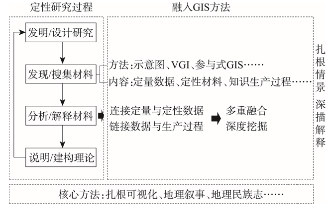
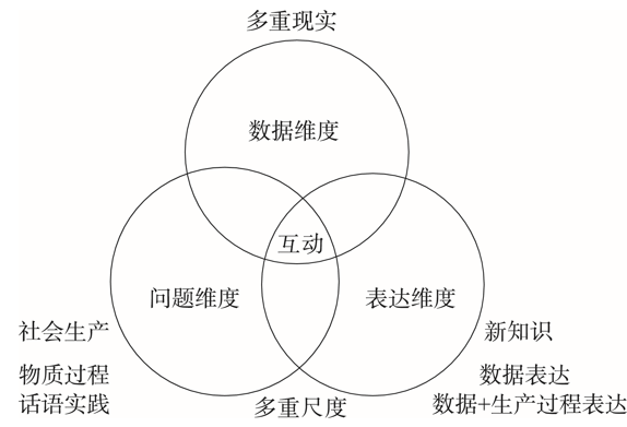