王亚军 , 李明启
, 李明启
中国科学院地理科学与资源研究所,中国科学院陆地表层格局与模拟重点实验室,北京 100101
WANG Yajun, LI Mingqi
通讯作者:
版权声明: 2016 地理科学进展 《地理科学进展》杂志 版权所有
基金资助:
作者简介:
作者简介:王亚军(1973-),女,辽宁凌源人,博士后,主要从事气候变化与树轮气候学研究,E-mail:hbyjwang@163.com。
展开
摘要
树木年轮资料定年准确、分辨率高、连续性强,已成为研究过去全球变化的重要信息来源之一。中国树轮与干湿变化研究,样点分布广泛,研究树种较多,重建尺度较长。基于树轮宽度、密度和同位素等各种代用指标,在分析树木径向生长对干湿变化响应、重建历史时期干湿变化等方面取得很大进展。一般来说,在干旱半干旱区的低海拔区域,水分条件,尤其是春季、秋季和年湿润状况,是树木径向生长的重要影响因素。森林上限、相对冷湿区域以及亚热带气候区,树木生长与降水的相关性偏弱。在时间尺度上,基于树轮重建的长于1000年甚至超过2000年的干湿变化序列已有多条,主要分布在青藏高原地区。目前最长年表已达4500年,最长降水序列为3500年。本文通过对部分树轮成果的简要概括,以期为树轮采样和干湿变化重建提供借鉴与帮助。
关键词:
Abstract
With accurate dating, high resolution, and high continuity, tree-ring data become one of the important sources for reconstructing the climate change. The sampling sites distribute widely, many tree species were selected, and the chronologies are very long for studying the relationship of the tree ring and dry-wet changes in China. Significant progress has been made in analyzing the response of tree radial growth to dry-wet changes and reconstructing historical dry-wet climate change based on various research proxies, such as tree-ring width, density, and stable isotopes. In general, moisture condition, especially in the spring and autumn and annual humidity are the important influencing factors of tree-radial growth in low altitudes of arid and semi-arid areas. For trees in the upper limit of forest vegetation, relatively cold-wet areas, and the subtropical climate zone in China, the correlation between tree growth and precipitation was weak. Dry-wet climate reconstruction based on tree-ring data in China is plentiful. Up to now, many precipitation series of more than 1000a or even over 2000a were reconstructed in a large number of regions. The longest tree-ring chronology is 4500a, and the longest precipitation reconstruction sequence is 3500a. The brief summary of selected tree-ring results in this article will provide references and help for tree-ring sampling and dry-wet climate reconstruction.
Keywords:
自20世纪80年代国际地圈—生物圈计划(IGBP)发起以来,关于全球及区域范围的气候与环境变化成为研究热点。过去全球变化计划(PAGES)作为IGBP的核心计划之一,着重于高分辨率古气候资料的获取及气候重建。树木年轮资料具有季节或年的高分辨率、连续性强、分布广泛,在历史时期气候变化研究中,起到了不可替代的作用,成为获取过去气候变化信息的重要来源之一(LaMarche, 1974; Hughes et al, 1984; Moberg et al, 2005; Cook et al, 2010)。
树木年轮气候学是根据树木径向生长推断和重建过去长期气候变化的科学,注重研究气候要素(降水、气温、光等)与树木生长的关系。中国树木年轮气候学研究始于20世纪30年代,70-80年代大范围开展,采样、室内分析等经验也逐渐积累(吴祥定, 1990b)。迄今为止,中国已大范围开展了树轮气候学研究。中国东部、中部及西部地区建立了大量树木年轮年表,如东北长白山(邵雪梅等, 1997; 陈列等, 2013; 陈力等, 2014)、包头(刘禹等, 2001)、呼和浩特(刘禹等, 1999)、华山(邵雪梅等, 1994)、贺兰山(Liu et al, 2004; 刘禹等, 2005)、川西高原(邵雪梅等, 1999)、祁连山东段(勾晓华等, 1999)和中段(Zhang et al, 2011)、柴达木盆地东北(邵雪梅等, 2006)、天山(袁玉江等, 2000)等。分析树木径向生长对气候要素变化的响应,并利用其重建历史时期降水、气温和径流等变化,为历史时期环境演变研究提供了可靠的科学数据。本文主要概述中国利用树轮重建干湿变化的若干研究,分别从树轮重建干湿变化所采用的代用指标、树木径向生长对干湿变化的响应以及基于树木年轮重建干湿变化研究工作的分布等3个方面加以阐述。
目前,利用树木年轮资料重建区域干湿变化的代用指标主要有宽度、密度、同位素和图像分析等。
树木年轮宽度是树轮气候学研究中利用最早的指标,也是重建历史时期干湿变化的主要代用指标。早在20世纪70-80年代,吴祥定等利用树轮宽度数据重建了西藏(吴祥定等, 1978)和横断山区(吴祥定等, 1987)过去气候演化历史,揭示了过去数百年来这2个区域的温度和降水变化过程。此后,越来越多的中国研究人员投入树轮气候学研究,利用树轮宽度数据重建了中国不同区域过去数百年至数千年的干湿变化过程(包括降水、帕默尔干旱指数PDSI等)。如内蒙古呼和浩特过去近376年来2-6月降水量演变历史的重建(刘禹等, 1999),青藏高原东北部降水变化的重建(Zhang et al, 2003; Shao et al, 2005; 黄磊等, 2005; 邵雪梅等, 2006),祁连山区(勾晓华等, 2001; Gou et al, 2015)、宁夏(马利民, 刘禹, 蔡秋芳等, 2003; Liu et al, 2004)、山西(李强等, 2006)、陕西(蔡秋芳等, 2005)、河南(张艳华等, 2013)、新疆(袁玉江等, 2000; 崔宇等, 2007; 张同文等, 2008)、甘肃(刘昶智等, 2013)等地的降水变化重建等。经过多年积累,邵雪梅等在2010年发表了利用活树、死树及古墓中出土的祁连圆柏建立的当时中国最长的宽度年表(3585年),该年表反映柴达木盆地的降水变化(Shao et al, 2010)。随后,Yang等(2014)同样利用活树、死树及墓葬中祁连圆柏将中国的树轮宽度年表延长到了4500年前,并重建了柴达木盆地过去3500年的降水变化。可见,中国利用树轮宽度资料推测过去区域干湿演变历史研究取得了丰硕的成果。
树木年轮密度分析是树轮气候学研究在20世纪80年代的一个突破(吴祥定等, 1994),最早尝试用于树轮宽度变化不大的情况(吴祥定, 1990a)。中国树轮密度研究工作始于20世纪90年代初。吴祥定等(1994)在研究秦岭树木年轮密度与气候变化的关系后,指出利用密度年表分析过去气候变化是可行的。目前大量研究发现,树轮密度与温度变化密切相关,且已用于重建历史时期温度变化(Chen et al, 2009; Chen et al, 2012a; Yu et al, 2013; Chen et al, 2014)。不过众多研究成果也表明了树轮密度在干湿变化重建中具备一定潜力。研究发现,华山树轮最小密度变化与5-6月降水量显著负相关,最大密度与7月降水显著正相关(吴祥定等, 1994)。随后,根据早材最小密度重建了陕西黄陵4-6月降水序列(刘禹等, 1997)。黑龙江树轮密度与气象要素关系表明,漠河兴安落叶松最大密度与8月降水显著负相关,樟子松最小密度与4月降水显著正相关(王丽丽等, 2005)。鄂尔多斯中部1888-2002年6-10月降水量变化则是采用油松树轮最大密度重建(杨银科等, 2013)。相对于树轮宽度指标来说,密度用于重建干湿变化的研究较少。
树轮中稳定同位素比例的变化,与气候要素变化存在着一定关联,所以国内外许多学者致力于研究树轮碳、氢和氧同位素变化。中国树轮稳定同位素研究近年发展迅速,在新疆昭苏地区(陈拓等, 2000)、天山(Xu et al, 2014a)、阿尔泰山(Xu et al, 2014b; 张瑞波等, 2015)、西藏林芝(刘晓宏等, 2002)、柴达木盆地(Wang, Liu et al, 2013)、巴塘理塘高原(An et al, 2014)、川西卧龙亚高山(靳翔等, 2013)、贡嘎山(Liu, Zhao et al, 2011)、贺兰山(马利民, 刘禹, 赵建夫等, 2003; Liu et al, 2008)和天目山(钱君龙等, 2001; Qian et al, 2002; 赵兴云等, 2005)等地的树轮同位素研究工作取得了卓越成果。
图像分析也是一种成功的树轮气候学分析方法。树轮微观结构如细胞大小、细胞壁厚度、导管的厚薄直接影响年轮灰度。寻找年轮灰度与气候变化的关系,从而提取气候变化信息。刘洪滨等(1996)首先用树轮图象分析方法研究了四川西部川西云杉年轮灰度与气候因子的相关关系。天山北坡西段博尔塔拉河流域的天山云杉树轮灰度研究表明,最大灰度与降水相关性较高,并重建了近百年来1-5月降水序列(潘娅婷等, 2007),说明利用树轮灰度参数重建干湿变化是可行的。此外,新疆伊犁雪岭云杉全轮灰度、早材灰度与6月降水相关较好(张瑞波, 喻树龙等, 2009)。此外,树轮灰度与密度呈显著负相关,使得树轮灰度能近似地反映树轮密度的变化,因而在研究中得到应用。
从已有研究成果看,年轮宽度、密度、同位素以及灰度等分析方法都已经独立地用于重建过去干湿变化且效果较为理想。不过,现在的树轮研究工作,开始倾向于尽可能采用多种指标,研究中相互印证,多途径分析,这也是树轮气候学发展的趋势之一。
中国幅员辽阔,自然环境千变万化,树木生长环境各不相同,树木径向生长的限制因素相差较大。众多研究结果表明,树木径向生长受区域干湿条件的控制,与不同月份以及不同时段干湿变化呈显著相关。本小节主要介绍树木径向生长对干湿变化的响应研究成果。
在众多树轮与干湿变化响应研究中,关于树木径向生长对干湿变化的敏感响应,抽取了3个主要时段进行概述,分别为:春季、秋季和年。
3.1.1 树木径向生长与春季干湿状况
春季树木开始萌芽生长,此时降水多,早材细胞分裂速度快、数量多且体积大。早材在整个年轮中所占比例大,所以降水多,树木易形成较宽年轮;反之,则形成窄年轮。众多研究成果均表明,树木年轮宽度与春季(月份)降水呈显著正相关,春季降水量多寡是制约树木径向生长的主要因素之一。如内蒙古包头地区树木轮宽与3月、4月和5月降水量均呈显著正相关(刘禹等, 2001),呼和浩特附近油松轮宽与4月和5月降水(刘禹等, 1999)显著正相关,华山松径向生长与5月和6月降水变化(邵雪梅等, 1994)显著正相关。另外,贺兰山油松轮宽与5月降水(Liu et al, 2004),祁连山东段祁连圆柏轮宽与3月和4月降水量(勾晓华等, 1999),祁连山西段树轮宽度与4月、5月和6月降水(Liang et al, 2009),祁连山东中—柴达木盆地东北祁连圆柏轮宽与5-6月降水(Zhang et al, 2013)以及柴达木盆地东北部祁连圆柏轮宽与3月、4月和5月土壤水分(Yin et al, 2008)、与3月和5月降水(Zhang et al, 2003)均呈显著正相关。此外,东北长白山岳桦(Yu et al, 2007)、南太行山万仙山油松(彭剑峰等, 2011)、大别山油松(郑永宏等, 2012)、秦岭小陇山油松(Fang et al, 2012)、宁夏罗山油松(王亚军等, 2009)、柴达木盆地东缘青海云杉(李雁等, 2008)和喜马拉雅山糙皮桦(Dawadi et al, 2013)以及南天山北坡雪岭云杉(朱海峰等, 2004)等树木径向生长均与春季(月份)降水呈现显著正相关。
由此可见,中国大部分地区树木径向生长受到春季干湿条件的明显制约,对春季干湿状况响应显著。
3.1.2 树木径向生长与上一年秋季干湿状况
研究发现,树木径向生长除了与春季干湿变化密切相关外,还有一个重要时段也不容忽视,那就是秋季干湿状况。众多研究结果表明,秋季干湿与树木径向生长呈显著正相关。如研究发现,内蒙古海拉尔樟子松生长受到降水限制,与上年9月降水相关系数最高(Liu et al, 2009);包头地区树木年轮宽度与上年9月和10月降水量显著正相关(刘禹等, 2001);阿尼玛卿山祁连圆柏第一主分量与上年10月降水(彭剑峰等, 2007a)、青海云杉与上年9月和10月降水(彭剑峰等, 2007b)、昌灵山油松与上年9月降水(Gao et al, 2005)、祁连山中段祁连圆柏与上年9月降水(Tian et al, 2012)均显著正相关。此外,对长白山不同海拔红松(陈列等, 2013)、宁夏罗山(王亚军等, 2009)、西藏林芝(刘晓宏等, 2003)、内蒙喀喇沁旗(Liu, Wang et al, 2011)、横断山脉(Fang et al, 2010)、山西汾河流域(Sun et al, 2012)、天山中段乌鲁木齐河流域(Xu et al, 2014a)、万仙山(彭剑峰等, 2011)、西大别山北坡(彭剑峰等, 2014)、天山中段海拔2256和2260 m的雪岭云杉(郭允允等, 2007)等的树轮气候学研究均表明,树木生长与上年秋季(月份)干湿变化呈显著正相关。
干旱地区针叶树树轮宽度与气候因子的相关关系表明,生长季前期的秋季等季节气候条件对树木生长具有显著影响(Fritts, 1976)。对青海牧草生长与气候条件的关系研究得出:如果上年秋雨多,土壤墒情好,即使春季旱一些,牧草仍可正常返青;反之,如果上年秋雨少,即便春雨接近历年同期平均值,也可能发生春旱而影响牧草返青(汪青春, 1998)。Yin等(2008)的研究指出,上年秋季月份土壤水分条件的累积效应影响植被生长。可见,秋雨对自然界植被生长具有非常重要的影响。在分析树木生长对干湿变化响应时,上一年生长季末期的秋季降水也是需要重点考虑的影响要素之一。
但必须指出的是,在中国气候湿润区,降水充足,树木径向生长对干湿变化呈现出不同的响应模式。如东南亚热带地区的福建,长苞铁杉与上年9月降水呈显著负相关关系(Chen et al, 2015),这种树木的径向生长—降水响应模式与中国北方大部分研究结果不一致,可能与所处气候区有关。
3.1.3 树木径向生长与年干湿状况
树木在生长过程中,如遇降水量多的年份,则生长用水需求得到满足,径向生长速度加快,易形成宽年轮,因此树木径向生长与年干湿状况密切相关。如内蒙古海拉尔(Liu et al, 2009)、喀喇沁(Liu, Wang et al, 2011)、内蒙古赤峰和围场(Liu et al, 2010)、昌灵山(Gao et al, 2005)、宁夏罗山(Wang, Lu et al, 2013)、祁连山东段(Liu et al, 2013)和中段(Zhang et al, 2011)、横断山(Fang et al, 2010)和柴达木盆地(邵雪梅等, 2006)等地的树轮气候学研究成果均表明,树木径向生长受到年湿润条件的显著制约。可见,在分析树木生长与干湿变化的相关性时,年湿润状况也是要重点考虑和分析的条件。
以上成果均表明树木径向生长对干湿变化的敏感响应,但也有一些区域树木径向生长与干湿变化相关关系相对偏弱。
首先是森林上限。高大山体森林上限树木生长与降水的相关性偏弱,主要反映温度信息。如天山北坡玛纳斯河流域(齐元元等, 2013)、柴达木盆地东部(Yin, Li et al, 2016)、祁连山(Liu et al, 2005)、横断山(吴祥定等, 1987)、阿尼玛卿山(Zhang, Shao et al, 2015)、川西高原(邵雪梅等, 1999)、川西邛崃山区(徐宁等, 2013)和秦岭太白山(康永祥等, 2010)等地的树轮气候学研究皆得出类似结论。如柴达木盆地东祁连圆柏上限100 m范围内,温度是树木生长的主要控制要素(Yin, Li et al, 2016);阿尼玛卿山祁连圆柏上限树木径向生长受到低温的显著制约(Zhang, Shao et al, 2015);川西米亚罗林区高海拔岷江冷杉生长也主要受温度限制,与冬季最低温度呈显著正相关(徐宁等, 2013)。
其次是相对冷湿区域。如东北地区,大兴安岭、小兴安岭和长白山树轮研究结果表明,部分地区树木径向生长对干湿变化响应相对不明显。大兴安岭低纬度和高纬度兴安落叶松(884~1160 m)径向生长与降水未表现出显著相关关系,降水变化对兴安落叶松径向生长的影响较小,不属于限制该区域此树种生长的主要因子(张朋磊等, 2015)。相对温度来说,小兴安岭不同海拔臭冷杉(海拔319~541 m)(姚启超等, 2013)的径向生长与降水相关性较弱。长白山低海拔(598 m)红松对降水响应不明显,主要受气温限制(陈力等, 2014);对于长白落叶松,低海拔(730~1258 m)树木径向生长与当年降水的相关系数未达到显著水平,高海拔(1790 m)长白落叶松生长则受气温影响,可能与此地水分条件能满足树木生长的生理要求有关(陈力等, 2014)。
再次是中国亚热带气候区。该区域树木生长与干湿变化的相关关系不明显。如东南地区福建的长苞铁杉,树木径向生长与大部分月份降水相关系数较小,而与大部分月份温度呈正相关,且相关系数较大;总体来看,长苞铁杉对干湿变化的响应,相对温度来说相对较弱(Chen et al, 2015);大别山黄山松径向生长与降水相关不显著,主要受当年2-7月平均气温限制(郑永宏等, 2012)。另外,东南地区的马尾松(Chen et al, 2012b)、长江下游的台湾松(Shi et al, 2010)、湖南和江西的马尾松(Duan et al, 2012)树木径向生长对干湿变化的响应也与此相似。
综上所述,树木径向生长对干湿变化的响应表现出复杂性。一般来说,在干旱半干旱区中低海拔地区,树木径向生长对干湿变化的响应敏感。如何从树木年轮中准确提取这些变化信息,是树木年轮气候学面临的复杂而艰巨的科学任务。
自从中国开展树轮研究以来,取得了丰硕成果,许多地区建立了树轮年表并重建历史时期干湿变化。图1展示了中国树轮研究成果分布概况(图1中气候区划引自“中国气候区划新方案”(郑景云等, 2010),并且对个别气候分区进行合并)。可见,尽管树轮样点分布广泛,但并不均衡,且重建序列长短不一,现有研究成果主要集中在中温带干旱区和高原亚寒带区。
图1 中国树轮重建干湿变化分布
Fig.1 Sites of dry-wet climate reconstruction by tree ring in China
中温带干旱区的树轮研究成果主要分布在西部的新疆及中部的内蒙等地。新疆地区树轮成果众多,最长的树轮年表850年,由帕米尔高原东北缘的昆仑圆柏树轮资料建立,树轮宽度主要受水分条件限制(尚华明等, 2015)。其中,长于500年的序列有:北疆526年的年降水变化序列(袁玉江等,1991)、阿勒泰西部1481-2004年6-9月降水量序列(张同文等, 2008)、1396-2005年天山南坡降水序列(张瑞波, 魏文寿等, 2009)等;还有部分重建序列少于500年(图1中紫色方块和蓝色圆点),如新疆天山的树轮成果(袁玉江等, 2001; 喻树龙等, 2005; 崔宇等, 2007; 王劲松等, 2007; 陈峰等, 2009; 尚华明等, 2010; 张录等, 2010; 高卫东等, 2011; 张瑞波等, 2013; Xu et al, 2014a; 秦莉等, 2014)、阿尔泰山的树轮成果(Xu et al, 2014b; 陈峰等, 2015; 张瑞波等, 2015)等。
中温带干旱半干旱区中部的干湿变化重建序列一般少于500年。该区位置与东亚季风边缘区北部接近。东亚季风边缘是年平均降水总量300~500 mm的区域(图2),考虑强弱季风年雨带进退(欧廷海等, 2006)的影响,由于季风强弱年际变化大,导致降水变率也较大,在该区降水量本就较少的背景下(徐袁等, 2003),致使树木径向生长对干湿变化响应敏感,并为众多研究所证实。图1显示,该区树轮研究成果颇多,如采用浑善达克沙地树木轮宽恢复了1842-2004年5-7月PDSI变化(Liang et al, 2007),依据贺兰山油松晚材轮宽重建1726-1997年5-7月降水变化(Liu et al, 2004);此外,还有内蒙古呼伦贝尔沙地南部樟子松(Liu et al, 2015)、内蒙古哈拉尔西山樟子松(Liu et al, 2009)、赤峰和围场油松(Liu et al, 2010)、喀喇沁油松(Liu, Wang et al, 2011)、锡林浩特白音敖包红皮云杉(Liu et al, 2003)、包头油松(刘禹等, 2001)、呼和浩特油松(刘禹等, 1999)、山西管涔山油松(李强等, 2006)、秦岭西段油松(Fang et al, 2012)、贺兰山油松(史江峰等, 2007)、昌灵山油松(Gao et al, 2005)、宁夏罗山油松(Wang, Lu et al, 2013)以及祁连山东段油松(Liu et al, 2013)等的树轮气候学研究成果。
图2 中国境内东亚季风边缘(虚线范围)(
Fig.2 The margin of East Asia Monsoon in China (dash line) (
上述研究成果表明,该区域以油松为主要树种进行历史时期干湿变化重建,结合野外实地考察,油松分布西缘基本位于祁连山附近。油松采样点如贺兰山(Liu et al, 2004)、昌灵山(Gao et al, 2005)、罗山(王亚军等, 2009)和祁连山东段(Liu et al, 2013)油松径向生长对气候要素变化敏感,且响应关系基本一致。油松是中国季风边缘区、尤其是季风区西北缘树轮气候学研究的理想树种。
高寒气候区的青藏高原东部,采样点密集,树轮研究成果众多,而且重建序列长。寻找长年代的树轮年表对于高分辨率的过去气候变化研究十分关键。该区域的树轮气候学研究特色是建立了中国最长的树轮年表,出现了众多长于1000年甚至超过2000年的重建干湿成果。以柴达木盆地东北的祁连圆柏树轮建立了长达4500年的序列(Yang et al, 2014),其次是3585年序列(Shao et al, 2010),并且重建了3500年的年降水序列(Yang et al, 2014),以及恢复了2847年以来的1-6月湿润状况序列(Yin, Zhu et al, 2016)。其他的长序列重建结果还有:青海东北都兰2500多年年降水序列(Sheppard et al, 2004),都兰2326年春季降水变化(Zhang et al, 2003),柴达木盆地东北边缘1437年年降水序列(邵雪梅等, 2006),青海德令哈和乌兰1436年的土壤水分序列(Yin et al, 2008),青海都兰1150年来年降水序列(Liu et al, 2006),祁连山中部1232年的年降水序列(Zhang et al, 2011)以及祁连山东段1002年来6-7月标准化降水蒸散指数(SPEI)变化序列(Gou et al, 2015)等。此外,还有500-1000年的重建序列,如青藏高原南部(刘晶晶, 2014)、青海都兰(Huang et al, 2007)、青海省境内不同区域(王振宇等, 2005)、祁连山中段(Tian et al, 2012)、横断山(Fang et al, 2010)等地干湿变化;少于500年的重建成果如横断山(Gou et al, 2013)、巴塘理塘高原(An et al, 2014)、青海南部(秦宁生等, 2003)等。表1为中国树木年轮重建干湿变化(大于500年)的部分研究成果。
表1 中国树木年轮重建干湿变化(多于500年)的部分研究成果
Tab.1 Selected research of dry-wet climate reconstruction (more than 500a) by tree ring in China
| 采样点 | 经度/°E | 纬度/°N | 高度/m | 树种 | 树轮指标 | 重建要素 | 文献 |
|---|---|---|---|---|---|---|---|
| 新疆北部 | 84.78 | 44.02 | 2510~2680 | 天山云杉 | 宽度 | 上年7-6月降水量 | Yang et al, 2012 |
| 天山南坡阿克苏河流域 | 79.09 | 41.55 | 2280~3600 | 雪岭云杉 | 宽度 | 上年8-4月降水量 | 张瑞波, 魏文寿等, 2009 |
| 阿勒泰地区西部 | 86.84 | 48.66 | 2273 | 西伯利亚落叶松 | 宽度 | 6-9月降水量 | 张同文等, 2008 |
| 华山 | 110.08 | 34.48 | 2030~2050 | 油松华山松 | 宽度 | 4-6月降水量 | Chen et al, 2016 |
| 横断山 | 99.29~99.45 | 27.31~27.59 | 3040~3060 | 川滇冷杉 | 宽度 | 上年5-4月PDSI | Fang et al, 2010 |
| 祁连山中段 | 99.73 | 38.78 | 2900~3150 | 祁连圆柏 | 宽度 | 上年8-7月降水量 | Tian et al, 2012 |
| 青藏高原南部 | 88.88~89.61 | 29.25~30.1 | 4124~4693 | 大果圆柏 | 宽度 | 上年7-6月降水量 | 刘晶晶, 2014 |
| 青海省境内 | 96.13~100.13 | 33.8~38.85 | 3500~4060 | 祁连圆柏 | 宽度 | 5-10月降水量 | 王振宇等, 2005 |
| 乌兰 | 98.68 | 37.03 | 3100~3800 | 祁连圆柏 | 宽度 | 5-6月降水量 | Huang et al, 2007 |
| 青藏高原东北 | 96.83~98.66 | 37.03~37.54 | 2877~4060 | 祁连圆柏 | 宽度 | 湿润状况 | Shao et al, 2010 |
| 柴达木盆地东北 | 97.23~98.42 | 36.68~37.47 | 3660~3917 | 祁连圆柏 | 宽度 | 上年7-6月年降水量 | Shao et al, 2005 |
| 青藏高原东北 | 97.15~99.97 | 35.45~38.7 | 3205~3995 | 祁连圆柏 | 宽度 | 年降水量 | Yang et al, 2014 |
| 祁连山 | 101.24~101.26 | 37.95~37.97 | 3164~3265 | 祁连圆柏 | 宽度 | 6-7月SPEI | Gou et al, 2015 |
| 柴达木盆地 | 97.53 | 37.27 | 4000 | 祁连圆柏 | 宽度 | 生长季湿度 | Wang, Liu et al, 2013 |
| 德令哈和乌兰地区 | 97.06~98.66 | 36.68~37.51 | 3500~3920 | 祁连圆柏 | 宽度 | 上年7-6月年降水量 | 邵雪梅等, 2006 |
| 都兰地区、东昆仑山和 青海南部山脉之间 | 98.18~98.67 | 36.06~36.29 | 3800~4200 | 祁连圆柏 | 宽度 | 上年7-6月年降水量 | Liu et al, 2006 |
| 青海湖天峻地区 | 98.40 | 37.31 | 3500 | 祁连圆柏 | 宽度 | 前一年年降水量 | 时兴合等, 2009 |
| 青藏高原 | 91.51~102.02 | 29.45~37.37 | 3260~4440 | 祁连圆柏 | 宽度 | 5-6月PDSI | Zhang, Evans et al, 2015 |
| 柴达木盆地东北 | 97.06~98.66 | 36.68~37.51 | 3500~3920 | 祁连圆柏 | 宽度 | 5-6月土壤湿度 | Yin et al, 2008 |
| 都兰2326 | 97.67~98.33 | 35.83~36.5 | 祁连圆柏 | 宽度 | 5-6月降水量 | Zhang et al, 2003 |
湿润、亚湿润区树轮与干湿变化研究相对较少,采样点分布稀疏,重建序列有:华山1482-2012年4-6月降水变化序列(Chen et al, 2016)、近500年来5-6月干燥指数变化序列(刘洪滨等, 2002),秦岭1629-2009年4-7月降水序列(Fang et al, 2012),浙江天目山长达300多年9月降水量序列(赵兴云等,2005),以及大兴安岭北部阿里河过去200年冬季降水序列(吕姗娜等, 2014)等。
海量的树轮与干湿变化研究成果,表明了中国树轮气候学研究取得了重大进展:采样地域广泛,研究树种增多,重建尺度延长。通过对所收集部分成果的归纳总结,试图得出一定的规律,以期为未来树轮干湿变化研究提供一定借鉴与帮助。
由于自然界条件千差万别,树木径向生长对水热变化的响应方式也错综复杂。就收集到的中国树轮反映干湿变化成果来看,在干旱半干旱地区,中下限树木径向生长受水分条件制约作用明显,高大山体树种分布上限以及相对湿润地区,从树木径向生长中更易找到热量信号。当然这也不是一成不变的规律。要掌握树木径向生长对于水分变化的响应规律,还需作更加细致、深入的工作,如采样点降水、气温、地温、空气湿度、海拔、树种、坡度、坡向、土壤、生物种群、甚至土壤中微生物,总之越详细越有利于规律的归纳与总结,也更有利于提高判别的准确度。
自然界生长的树木,见证并且记录了气候干湿变化。一般来说,从较大的时间尺度看,比如10年际,处于同一气候区的树木,径向生长反映的干湿变化可能一致性较强;邻近地区的树木,记录的干湿变化也具备同步性。尤其是对于一些较大的气候事件,比如受海气耦合等大范围气候变化驱动机制影响的干旱事件,因干旱强度大、影响范围广,在半球甚至全球范围内留下痕迹,树木径向生长会同时记录下这些事件。但如果从年际尺度看,相同气候区甚至邻近地区树木径向生长记录的干湿变化起止时间可能存在差异,这是由众多影响因素造成的,如纬度、经度、高度、坡向、坡度、土壤、树种、种群和生境等。以树种为例,即使自然界中存在其他条件完全相同的地域,不同的树种由于自身遗传特性差异,可能对外界变化的滞后响应方式也不同,从而导致记录的干湿变化起止时间出现不同步。另外,对于不同坡向条件,树木可利用的热量水分条件存在差异,即使是同一树种、同一海拔,也会记录下不同的外界变化信息。
目前本文仅对部分树轮反映干湿变化工作作了一个初步总结。更为全面准确的归纳和总结还有待于日后对树轮文献进行更深入的研究。
The authors have declared that no competing interests exist.
| [1] |
陕西黄龙树轮年表的建立及其2-3月降水记录 [J].
通过两组油松树轮宽度的研究,建立了陕西黄龙地区过去近200 a来的树轮STD、RES、ARS年表,树轮宽度在20世纪20年代有过明显的下降,1929年前后达到年轮宽度最低值,与历史记载的自民国11年以来连 续干旱时期相吻合(1922-1932年).经过相关函数、响应函数分析,发现树轮宽度与生长季当年2-3月降水显著正相关,在此基础上设计了转换方程, 重建了过去200 年来黄龙地区早春2-3月降水历史,重建序列的解释方差为44.3%(F=16.298,p<0.001).功率谱分析检测到2-3月降水存在 7.69、6.90、6.06、5.13、5.00、4.88、4.65、2.02、2.00 年的周期.
The reconstruction of tree-ring chronology and early spring (from February to March) precipitation information in Huanglong region, Shaanxi Province [J].
通过两组油松树轮宽度的研究,建立了陕西黄龙地区过去近200 a来的树轮STD、RES、ARS年表,树轮宽度在20世纪20年代有过明显的下降,1929年前后达到年轮宽度最低值,与历史记载的自民国11年以来连 续干旱时期相吻合(1922-1932年).经过相关函数、响应函数分析,发现树轮宽度与生长季当年2-3月降水显著正相关,在此基础上设计了转换方程, 重建了过去200 年来黄龙地区早春2-3月降水历史,重建序列的解释方差为44.3%(F=16.298,p<0.001).功率谱分析检测到2-3月降水存在 7.69、6.90、6.06、5.13、5.00、4.88、4.65、2.02、2.00 年的周期.
|
| [2] |
天山北坡呼图壁河流域近313年降水的重建与分析 [J].
分析发现,天山北坡呼图壁河流域树轮年表与呼图壁气象站上年8月至当年7月的平均降水相关性较好,最高单相关系数为o.484(a=0.001),且具有明显的树木生理学意义.利用赛热克巴依萨、希热克久热特、喀音萨依的标准化年表能够较好地重建呼图壁河流域近313年的上年8月至当年7月平均降水序列,方差解释量达41%,并通过交叉检验表明重建结果稳定可靠.
Reconstruction and analysis of precipitation in the Hutubi River Basin on the northern slope of the Tianshan Mountains during the last 313 years [J].
分析发现,天山北坡呼图壁河流域树轮年表与呼图壁气象站上年8月至当年7月的平均降水相关性较好,最高单相关系数为o.484(a=0.001),且具有明显的树木生理学意义.利用赛热克巴依萨、希热克久热特、喀音萨依的标准化年表能够较好地重建呼图壁河流域近313年的上年8月至当年7月平均降水序列,方差解释量达41%,并通过交叉检验表明重建结果稳定可靠.
|
| [3] |
树轮记录的阿尔泰山北部PDSI指数变化及其对额尔齐斯河径流变化影响 [J].https://doi.org/10.13448/j.cnki.jalre.2015.263 URL [本文引用: 3] 摘要
相关分析揭示阿尔泰山北部低海拔山地的西伯利亚落叶松树轮年表与 帕尔默干旱指数(PDSI)之间存在显著相关.因此,文中利用该树轮年表重建了阿尔泰山北部过去251年来1-8月的PDSI指数变化,方差解释量达 43.4%.该PDSI指数重建序列与周边地区PDSI指数的变化趋势比较一致,并能够表征额尔齐斯河径流变化.重建结果揭示了19世纪末期极端干旱阶段 和自20世纪末期以来暖湿化的减缓.同时,研究还揭示来自北冰洋水汽和西风强度变化对于研究区干湿变化起着关键性作用.
Long-term drought severity variations in the northern Altay Mountains and its linkages to the Irtysh River streamflow variability [J].https://doi.org/10.13448/j.cnki.jalre.2015.263 URL [本文引用: 3] 摘要
相关分析揭示阿尔泰山北部低海拔山地的西伯利亚落叶松树轮年表与 帕尔默干旱指数(PDSI)之间存在显著相关.因此,文中利用该树轮年表重建了阿尔泰山北部过去251年来1-8月的PDSI指数变化,方差解释量达 43.4%.该PDSI指数重建序列与周边地区PDSI指数的变化趋势比较一致,并能够表征额尔齐斯河径流变化.重建结果揭示了19世纪末期极端干旱阶段 和自20世纪末期以来暖湿化的减缓.同时,研究还揭示来自北冰洋水汽和西风强度变化对于研究区干湿变化起着关键性作用.
|
| [4] |
长白山不同海拔树木生长对气候变化的响应差异 [J].https://doi.org/10.5846/stxb201210121415 Magsci [本文引用: 4] 摘要
以长白落叶松和红松为例,探讨了长白山地区不同海拔树木生长对气候变化的响应。利用长白山北坡不同海拔4个长白落叶松样点和6个红松样点的树轮宽度资料建立差值年表,通过聚类分析、相关分析和响应分析等方法,研究树木生长特征及其气候响应。结果表明:两个树种年表的平均敏感度、树轮宽度指数的年际变率、信噪比等特征值较高,反映年表含有较强的环境信息。随海拔升高,长白落叶松年表特征值呈先下降后增加的趋势,红松年表特征值则呈先增加后下降的趋势。聚类分析将长白落叶松年表分成高、低海拔两类,红松年表分成高、中、低海拔三类。树木生长对气候响应存在海拔差异。高海拔长白落叶松生长受当年气温影响;低海拔长白落叶松生长对气候存在“滞后响应”。高海拔红松不仅受降水限制,且对气温有“滞后响应”;中海拔红松不仅受气温限制,且对降水有“滞后响应”;低海拔红松生长主要受气温限制。
Climate response of tree growth along an altitudinal gradient in the Changbai Mountains, Northeast China [J].https://doi.org/10.5846/stxb201210121415 Magsci [本文引用: 4] 摘要
以长白落叶松和红松为例,探讨了长白山地区不同海拔树木生长对气候变化的响应。利用长白山北坡不同海拔4个长白落叶松样点和6个红松样点的树轮宽度资料建立差值年表,通过聚类分析、相关分析和响应分析等方法,研究树木生长特征及其气候响应。结果表明:两个树种年表的平均敏感度、树轮宽度指数的年际变率、信噪比等特征值较高,反映年表含有较强的环境信息。随海拔升高,长白落叶松年表特征值呈先下降后增加的趋势,红松年表特征值则呈先增加后下降的趋势。聚类分析将长白落叶松年表分成高、低海拔两类,红松年表分成高、中、低海拔三类。树木生长对气候响应存在海拔差异。高海拔长白落叶松生长受当年气温影响;低海拔长白落叶松生长对气候存在“滞后响应”。高海拔红松不仅受降水限制,且对气温有“滞后响应”;中海拔红松不仅受气温限制,且对降水有“滞后响应”;低海拔红松生长主要受气温限制。
|
| [5] |
长白山北坡不同林型内红松年表特征及其与气候因子的关系 [J].https://doi.org/10.5846/stxb201209181309 Magsci [本文引用: 2] 摘要
运用树木年轮学的基本原理和方法,选取了长白山北坡保存完好的典型性植被阔叶红松林,探讨了杨桦红松林和椴树红松林内建群种红松(<em>Pinus koraiensis</em>)径向生长对气候要素的响应。结果表明,长白山北坡红松的径向生长对降水较为敏感,杨桦红松林和椴树红松林中,红松年轮宽度均与当年7月以及上一年9月的降水呈显著正相关关系。不同林型内红松的生长与气候因子的关系也有差异。椴树红松的年轮宽度还与上年7月的降水显著负相关,与当年3、4月份的平均气温呈显著正相关。而杨桦红松林内红松年轮宽度和平均温度没有显著的相关关系。特征年分析进一步验证了响应函数相关分析的结果,即当年生长季以及上年生长季末的降水充足促进了红松的径向生长;椴树红松林中,初春温度的升高有利于红松的生长。
Characteristics of tree-ring chronology of Pinus koraiensis and its relationship with climate factors on the northern slope of Changbai Mountain [J].https://doi.org/10.5846/stxb201209181309 Magsci [本文引用: 2] 摘要
运用树木年轮学的基本原理和方法,选取了长白山北坡保存完好的典型性植被阔叶红松林,探讨了杨桦红松林和椴树红松林内建群种红松(<em>Pinus koraiensis</em>)径向生长对气候要素的响应。结果表明,长白山北坡红松的径向生长对降水较为敏感,杨桦红松林和椴树红松林中,红松年轮宽度均与当年7月以及上一年9月的降水呈显著正相关关系。不同林型内红松的生长与气候因子的关系也有差异。椴树红松的年轮宽度还与上年7月的降水显著负相关,与当年3、4月份的平均气温呈显著正相关。而杨桦红松林内红松年轮宽度和平均温度没有显著的相关关系。特征年分析进一步验证了响应函数相关分析的结果,即当年生长季以及上年生长季末的降水充足促进了红松的径向生长;椴树红松林中,初春温度的升高有利于红松的生长。
|
| [6] |
新疆昭苏云杉树轮纤维素δ13C的气候意义 [J].
依据树轮纤维素δ<sup>13</sup>C测定数据,分析了其气候意义.结果表明,树轮Δ<sup>13</sup>C与气候诸要素之间有明显的相关性,包括降水、相对湿度、温度、日照时间(或太阳辐射)等,部分原因可归咎于云杉是一种浅根系植物、其生长对气候的变化较为敏感,因为它生长过程中所必需的各种养分和水分均是根系吸收的.分析表明,温度与树轮Δ<sup>13</sup>C的相关性是它们与相对湿度或降水之间交互相关的结果,日照时间与树轮Δ<sup>13</sup>C呈正相关与光呼吸有关.利用树轮Δ<sup>13</sup>C与降水之间的函数关系,恢复了近300a来新疆昭苏地区的降水变化,恢复的系列与历史文献记录和树轮指数所揭示的降水历史有较好的对应性.
Study on climatic significance of fir tree-ring δ13C from Zhaosu County of Xinjiang region, China [J].
依据树轮纤维素δ<sup>13</sup>C测定数据,分析了其气候意义.结果表明,树轮Δ<sup>13</sup>C与气候诸要素之间有明显的相关性,包括降水、相对湿度、温度、日照时间(或太阳辐射)等,部分原因可归咎于云杉是一种浅根系植物、其生长对气候的变化较为敏感,因为它生长过程中所必需的各种养分和水分均是根系吸收的.分析表明,温度与树轮Δ<sup>13</sup>C的相关性是它们与相对湿度或降水之间交互相关的结果,日照时间与树轮Δ<sup>13</sup>C呈正相关与光呼吸有关.利用树轮Δ<sup>13</sup>C与降水之间的函数关系,恢复了近300a来新疆昭苏地区的降水变化,恢复的系列与历史文献记录和树轮指数所揭示的降水历史有较好的对应性.
|
| [7] |
乌鲁木齐河源467年春季降水的重建与分析 [J].Reconstruction and analysis of 467-year spring precipitation series in the Urumqi River head [J]. |
| [8] |
树木年轮记录的天山北坡中部过去338a降水变化 [J].
<FONT face=Verdana>利用位于天山北坡中部9个气象站的降水资料与采自该地区的21个树木年轮年表序列进行分析。结果表明,9个气象站上年8月到当年7月的平均降水量与树木年轮标准化年表具有很好的相关性,最高单相关达到0.612(P<0.0001)。分析发现,生长季前期及春材形成期的降水变化对天山山区树木年轮径向生长量起着决定性作用。用四工河东白杨沟、呼图壁河赛热克巴依萨依、呼图壁河希热克久热特、四工河西白杨沟、奎屯河兰能果尔南5个标准化年表较好地重建了天山北坡中部近338 a来上年8月到当年7月的降水量,重建方程的方差解释量达到60.0%,经过统计检验和历史资料验证,表明重建序列是可靠的。对过去338 a天山北坡中部降水变化的特征分析表明,近338 a间,天山北坡中部降水大体经历了8个偏干和8个偏湿阶段,偏湿年份与偏干年份基本持平。最长的偏干阶段是1705—1750年,最干旱的阶段为1960—1989年,最干旱年份是1796年、1944年和1974年,降水偏少程度均大于27%;最长的偏湿阶段是1917—1959年,1690—1904年间为降水最为丰沛的时期。天山北坡中部338 a降水具有两年左右的变化准周期,在1751年发生了明显的由少到多的突变,在1958年前后发生了明显的由多到少的突变。</FONT>
The recent 338-year precipitation series reconstructed from tree-ring in northern slope of Tianshan Mountain [J].
<FONT face=Verdana>利用位于天山北坡中部9个气象站的降水资料与采自该地区的21个树木年轮年表序列进行分析。结果表明,9个气象站上年8月到当年7月的平均降水量与树木年轮标准化年表具有很好的相关性,最高单相关达到0.612(P<0.0001)。分析发现,生长季前期及春材形成期的降水变化对天山山区树木年轮径向生长量起着决定性作用。用四工河东白杨沟、呼图壁河赛热克巴依萨依、呼图壁河希热克久热特、四工河西白杨沟、奎屯河兰能果尔南5个标准化年表较好地重建了天山北坡中部近338 a来上年8月到当年7月的降水量,重建方程的方差解释量达到60.0%,经过统计检验和历史资料验证,表明重建序列是可靠的。对过去338 a天山北坡中部降水变化的特征分析表明,近338 a间,天山北坡中部降水大体经历了8个偏干和8个偏湿阶段,偏湿年份与偏干年份基本持平。最长的偏干阶段是1705—1750年,最干旱的阶段为1960—1989年,最干旱年份是1796年、1944年和1974年,降水偏少程度均大于27%;最长的偏湿阶段是1917—1959年,1690—1904年间为降水最为丰沛的时期。天山北坡中部338 a降水具有两年左右的变化准周期,在1751年发生了明显的由少到多的突变,在1958年前后发生了明显的由多到少的突变。</FONT>
|
| [9] |
利用树轮宽度重建近280a来祁连山东部地区的春季降水 [J].https://doi.org/10.3969/j.issn.1000-0240.2001.03.013 URL [本文引用: 1] 摘要
利用采自祁连山东部的祁连圆柏样芯样本,建立标准化年表,并将标 准年表的树轮指数与附近的乌鞘岭气象站的温度和降水进行相关分析.结果表明,年轮指数与3~4月降水呈显著正相关,相关系数为0.525.利用标准化年表 与3~4月降水的线性回归方程重建了研究区近280 a来的3~4月降水,统计检验表明重建结果是可靠的.
Spring precipitation reconstructed in the east of the Qilian Mountain during the last 280a by tree ring width [J].https://doi.org/10.3969/j.issn.1000-0240.2001.03.013 URL [本文引用: 1] 摘要
利用采自祁连山东部的祁连圆柏样芯样本,建立标准化年表,并将标 准年表的树轮指数与附近的乌鞘岭气象站的温度和降水进行相关分析.结果表明,年轮指数与3~4月降水呈显著正相关,相关系数为0.525.利用标准化年表 与3~4月降水的线性回归方程重建了研究区近280 a来的3~4月降水,统计检验表明重建结果是可靠的.
|
| [10] |
祁连山东部地区树木年轮年表的建立 [J].
利用采自祁连山东部的祁连圆柏样芯,经常规程序晾干、固定、打磨、定年和读数后,建立了标准化年表,并将标准年表的树轮指数与采样点附近的天祝乌鞘岭气象站的温度和降水进行了相关分析。结果表明,年轮指数与3~4月降水呈显著正相关,相关系数达0.525。由于3~4月份的降水为该地区树木生长季之初的降水,是树木生长的限制因子,因此该相关具有明确的生物学意义。研究还发现,年轮指数与1月气温也呈显著负相关(相关系数为- 0.297),这可能是由于冬季最冷月气温偏高时,影响树木代谢和土壤湿度,从而影响树木的生长。祁连山东部地区树木年轮年表具有明确的气候学意义。
The establishment of tree-ring chronology in east region of Qilian Mountains [J].
利用采自祁连山东部的祁连圆柏样芯,经常规程序晾干、固定、打磨、定年和读数后,建立了标准化年表,并将标准年表的树轮指数与采样点附近的天祝乌鞘岭气象站的温度和降水进行了相关分析。结果表明,年轮指数与3~4月降水呈显著正相关,相关系数达0.525。由于3~4月份的降水为该地区树木生长季之初的降水,是树木生长的限制因子,因此该相关具有明确的生物学意义。研究还发现,年轮指数与1月气温也呈显著负相关(相关系数为- 0.297),这可能是由于冬季最冷月气温偏高时,影响树木代谢和土壤湿度,从而影响树木的生长。祁连山东部地区树木年轮年表具有明确的气候学意义。
|
| [11] |
天山中段树木生长对气候垂直梯度的响应 [J].
文章通过天山中段垂直梯度上多个台站的气候资料,系统分析了不同海拔高度气候变化的时空差异性,以此作为与轮宽资料进行相关分析的基础。进一步利用气候条件较为一致的天山中段鹿角湾、乌鲁木齐河源山区和天池等地森林上限附近树木年轮宽度变化资料,结合前人在这一地区森林内部和森林下限所做的研究,探讨了天山中段树木生长对气候垂直梯度的响应。结果表明,天山山区最大降水高度有明显的季节变化,从而导致气候因子对树木生长影响的复杂性。除了海拔最高的采样点天池(TC)外,其他采样点均与上年8~9月降水总量正相关,与上年7~8月平均温度负相关,与当年4~5月降水总量正相关。而在海拔最高、高山林线附近的采样点与当年2月均温显著正相关,与当年5月气温显著负相关。可以认为,在研究区树木生长主要受到上年7~8月由高温引起的干旱和当年4~5月由降水不足导致的干旱的影响。在接近气候林线处,低温的限制作用才表现出来。
Responses of tree growth to vertical climate gradient in the middle section of the Tianshan Mountains [J].
文章通过天山中段垂直梯度上多个台站的气候资料,系统分析了不同海拔高度气候变化的时空差异性,以此作为与轮宽资料进行相关分析的基础。进一步利用气候条件较为一致的天山中段鹿角湾、乌鲁木齐河源山区和天池等地森林上限附近树木年轮宽度变化资料,结合前人在这一地区森林内部和森林下限所做的研究,探讨了天山中段树木生长对气候垂直梯度的响应。结果表明,天山山区最大降水高度有明显的季节变化,从而导致气候因子对树木生长影响的复杂性。除了海拔最高的采样点天池(TC)外,其他采样点均与上年8~9月降水总量正相关,与上年7~8月平均温度负相关,与当年4~5月降水总量正相关。而在海拔最高、高山林线附近的采样点与当年2月均温显著正相关,与当年5月气温显著负相关。可以认为,在研究区树木生长主要受到上年7~8月由高温引起的干旱和当年4~5月由降水不足导致的干旱的影响。在接近气候林线处,低温的限制作用才表现出来。
|
| [12] |
青海德令哈地区近400年来的降水量变化与太阳活动 [J].
<p>使用多种数学统计方法分析了德令哈地区降水量变化与太阳活动之间的关系,发现近400年来降水量的长期变化与太阳黑子周期长度(SCL)和太阳黑子周期上升支长度之间存在着较好的反相关关系,当SCL偏短、太阳黑子周期上升支长度偏短时,太阳活动偏强,德令哈地区降水量偏多,反之偏少。功率谱和小波分析发现降水量序列中存在着与太阳活动的多种周期相一致的周期,对降水量与太阳活动在不同时间尺度上周期变化之间的关系进行了详细分析。交叉小波分析发现太阳活动主要在百年左右尺度的周期变化上影响德令哈地区降水量的长期变化,太阳活动周期变化的信号越强,对降水量变化的影响越大。文章最后对太阳活动影响德令哈地区降水量变化的可能机制进行了探讨。</p>
Precipitation variation in Delingha, Qinghai and solar activity over the last 400 years [J].
<p>使用多种数学统计方法分析了德令哈地区降水量变化与太阳活动之间的关系,发现近400年来降水量的长期变化与太阳黑子周期长度(SCL)和太阳黑子周期上升支长度之间存在着较好的反相关关系,当SCL偏短、太阳黑子周期上升支长度偏短时,太阳活动偏强,德令哈地区降水量偏多,反之偏少。功率谱和小波分析发现降水量序列中存在着与太阳活动的多种周期相一致的周期,对降水量与太阳活动在不同时间尺度上周期变化之间的关系进行了详细分析。交叉小波分析发现太阳活动主要在百年左右尺度的周期变化上影响德令哈地区降水量的长期变化,太阳活动周期变化的信号越强,对降水量变化的影响越大。文章最后对太阳活动影响德令哈地区降水量变化的可能机制进行了探讨。</p>
|
| [13] |
川西亚高山森林岷江冷杉树轮碳稳定同位素对气候要素的响应 [J].https://doi.org/10.11707/j.1001-7488.20130702 Magsci [本文引用: 1] 摘要
<p>利用四川卧龙亚高山暗针叶林岷江冷杉树木年轮样本资料,建立树轮宽度年表,对比宽度年表,提取树木年轮(简称树轮)碳稳定同位素(<em>δ</em><sup>13</sup>C)序列和去趋势序列(DS),研究岷江冷杉树轮碳稳定同位素序列对气候要素的响应关系。结果表明: 岷江冷杉(1904—2009年)树轮碳稳定同位素变化范围为-23.33‰~-26.31‰,平均值为-24.91‰,变异系数为-0.025; 相关分析表明,岷江冷杉<em>δ</em><sup>13</sup>C序列(DS)与前一年11月和当年1月的月平均气温显著正相关(<em>P</em>≤0.05),与前一年1月和当年2, 11月的月平均气温极显著正相关(<em>P</em>≤0.01),冬季平均气温对岷江冷杉树轮碳稳定同位素的响应最为敏感,是研究过去环境变化的良好载体, 与当年1月降水量显著正相关(<em>P</em>≤0.05), 与全年的月平均相对湿度相关性不显著(<em>P</em>≥0.05)。</p>
Relationships of stable carbon isotope of Abies faxoniana tree-rings to climate in the sub-alpine forest in western Sichuan [J].https://doi.org/10.11707/j.1001-7488.20130702 Magsci [本文引用: 1] 摘要
<p>利用四川卧龙亚高山暗针叶林岷江冷杉树木年轮样本资料,建立树轮宽度年表,对比宽度年表,提取树木年轮(简称树轮)碳稳定同位素(<em>δ</em><sup>13</sup>C)序列和去趋势序列(DS),研究岷江冷杉树轮碳稳定同位素序列对气候要素的响应关系。结果表明: 岷江冷杉(1904—2009年)树轮碳稳定同位素变化范围为-23.33‰~-26.31‰,平均值为-24.91‰,变异系数为-0.025; 相关分析表明,岷江冷杉<em>δ</em><sup>13</sup>C序列(DS)与前一年11月和当年1月的月平均气温显著正相关(<em>P</em>≤0.05),与前一年1月和当年2, 11月的月平均气温极显著正相关(<em>P</em>≤0.01),冬季平均气温对岷江冷杉树轮碳稳定同位素的响应最为敏感,是研究过去环境变化的良好载体, 与当年1月降水量显著正相关(<em>P</em>≤0.05), 与全年的月平均相对湿度相关性不显著(<em>P</em>≥0.05)。</p>
|
| [14] |
太白山不同海拔太白红杉年轮生长对气候变化的响应 [J].
【目的】研究不同海拔太白红杉年轮宽度序列对气候变化的响应。【方法】以太白红杉为研究对象,在太白山同一坡向、不同海拔(3100,3200,3300和3400m)分别设立样地,用生长锥法在树高1.3m处钻取木芯,经晾干、打磨后,使用WinDENDROTM年轮分析系统进行轮宽测量和交叉定年,并分别建立各海拔年表;利用相关分析及响应分析统计方法,对年轮与气候因子的相关性及响应函数解释量进行研究。【结果】最高海拔4号样地与其他样地的相关性分析结果存在较大差异。当年生长季(3,4,6,7月)温度与1,2,3号样地太白红杉年轮指数序列均呈正相关,而与4号样地呈负相关;当年生长季(3,4,7月)降水量与1,2,3号样地年轮指数序列均呈负相关(4月份3号样地除外),而与4号样地呈正相关。由响应函数分析可知,低海拔采样点1号样地,气象要素(温度和降水量)在响应函数解释量中所占的比重较高;但与降水量相比,高海拔林线采样点4号样地温度的解释量明显较大。【结论】太白红杉林最高海拔样地年轮指数序列变化与其他样地有明显差异;在响应函数分析中,气候要素对最低海拔样地年表贡献率最大,但最高海拔太白红杉生长对温度表现出较强的敏感性。
Characteristics of ring-width chronologies of Larix chinensis and their responses to climate change at different elevations in Taibai Mountain [J].
【目的】研究不同海拔太白红杉年轮宽度序列对气候变化的响应。【方法】以太白红杉为研究对象,在太白山同一坡向、不同海拔(3100,3200,3300和3400m)分别设立样地,用生长锥法在树高1.3m处钻取木芯,经晾干、打磨后,使用WinDENDROTM年轮分析系统进行轮宽测量和交叉定年,并分别建立各海拔年表;利用相关分析及响应分析统计方法,对年轮与气候因子的相关性及响应函数解释量进行研究。【结果】最高海拔4号样地与其他样地的相关性分析结果存在较大差异。当年生长季(3,4,6,7月)温度与1,2,3号样地太白红杉年轮指数序列均呈正相关,而与4号样地呈负相关;当年生长季(3,4,7月)降水量与1,2,3号样地年轮指数序列均呈负相关(4月份3号样地除外),而与4号样地呈正相关。由响应函数分析可知,低海拔采样点1号样地,气象要素(温度和降水量)在响应函数解释量中所占的比重较高;但与降水量相比,高海拔林线采样点4号样地温度的解释量明显较大。【结论】太白红杉林最高海拔样地年轮指数序列变化与其他样地有明显差异;在响应函数分析中,气候要素对最低海拔样地年表贡献率最大,但最高海拔太白红杉生长对温度表现出较强的敏感性。
|
| [15] |
山西宁武地区1686年以来年降水重建 [J].
根据山西北部宁武地区的树轮宽度指标,建立了该地区过去318年的树轮STD,RES和ARS年表,发现上年8月至当年7月 (全年)的降水与差值年表(RES)显著相关 (<em>r</em>=0.71, n=50),在此基础上设计了转换方程,重建了宁武地区1686年以来的全年降水,方差解释量达到 48.6%(调整自由度后为46.8%, <em>r</em>=0.697,<em>F</em>=26.471, <em>p</em><0.0001)。降水量较少的时段为1693~1710年,1720~1764年,1825~1841年,1873~1882年,1901~1930年,1966~1972年和1988~2003年,降水量较多的时段为1711~1720年, 1765~1824年,1842~1872年,1883~1886年和1931~1987年。 历史文献记录的干旱年份在重建序列上均有所反映。重建序列与贺兰山1~7月降水显著相关 (99%置信度下, <em>r</em>=0.312)。功率谱分析表明山西宁武上年8月至当年7月降水含有2.34~2.68年,4.92年,5.26年的显著周期,可能与ENSO活动有关。
Reconstruction of annual precipitation since 1686 A.D. from Ningwu region, Shanxi Province [J].
根据山西北部宁武地区的树轮宽度指标,建立了该地区过去318年的树轮STD,RES和ARS年表,发现上年8月至当年7月 (全年)的降水与差值年表(RES)显著相关 (<em>r</em>=0.71, n=50),在此基础上设计了转换方程,重建了宁武地区1686年以来的全年降水,方差解释量达到 48.6%(调整自由度后为46.8%, <em>r</em>=0.697,<em>F</em>=26.471, <em>p</em><0.0001)。降水量较少的时段为1693~1710年,1720~1764年,1825~1841年,1873~1882年,1901~1930年,1966~1972年和1988~2003年,降水量较多的时段为1711~1720年, 1765~1824年,1842~1872年,1883~1886年和1931~1987年。 历史文献记录的干旱年份在重建序列上均有所反映。重建序列与贺兰山1~7月降水显著相关 (99%置信度下, <em>r</em>=0.312)。功率谱分析表明山西宁武上年8月至当年7月降水含有2.34~2.68年,4.92年,5.26年的显著周期,可能与ENSO活动有关。
|
| [16] |
柴达木盆地东缘青海云杉树轮细胞结构变化特征及其对气候的指示 [J].
<FONT face=Verdana>基于青海柴达木盆地东缘山地青海云杉生长上限的树轮样本,在获取树轮宽度数据<BR>的同时,获取了细胞特征指标,包括细胞个数和细胞大小,建立了树轮早材、晚材、整轮的<BR>细胞个数标准年表和细胞大小的最大值、最小值年表,并通过与附近茶卡气象站过去31年(<BR>1970—2000年)逐月降水量和温度的相关分析和响应函数分析,从细胞尺度探讨了青海云杉<BR>生长与外界气候要素的关系.结果表明:早材细胞个数与冬半年(上年10月至当年3月)温<BR>度之间呈正相关关系;晚材细胞个数除了与11月和12月最低温度呈显著正相关外,还与生长季<BR>中7月和8月平均温度呈显著相关关系;早、晚材细胞个数同时与7月的降水量呈显著负相关.<BR>早材细胞个数与5月的降水量呈正相关关系.对于早材最大细胞大小的年表来说,其变化与2<BR>月的降水量变化有很好的一致性,而晚材最小细胞的大小与8月降水量的变化同步.细胞个<BR>数和细胞大小不仅记录了树轮宽度所记录的温度变化信息,还额外记录了一定的降水信息,<BR>说明不同的树木生长指标能够记录不同的气候信息.利用同一地点同一树种不同类型的树轮<BR>指标,能够提取多种气候要素的变化信息,这对将来从同一样点的树轮资料中提取更丰富的<BR>气候信息以及发掘树轮气候学的潜力具有一定意义.</FONT>
Variations of Picea crassifolia tree-ring cell structure and their implications to past climate in eastern margin of Qaidam Basin, Northwest China [J].
<FONT face=Verdana>基于青海柴达木盆地东缘山地青海云杉生长上限的树轮样本,在获取树轮宽度数据<BR>的同时,获取了细胞特征指标,包括细胞个数和细胞大小,建立了树轮早材、晚材、整轮的<BR>细胞个数标准年表和细胞大小的最大值、最小值年表,并通过与附近茶卡气象站过去31年(<BR>1970—2000年)逐月降水量和温度的相关分析和响应函数分析,从细胞尺度探讨了青海云杉<BR>生长与外界气候要素的关系.结果表明:早材细胞个数与冬半年(上年10月至当年3月)温<BR>度之间呈正相关关系;晚材细胞个数除了与11月和12月最低温度呈显著正相关外,还与生长季<BR>中7月和8月平均温度呈显著相关关系;早、晚材细胞个数同时与7月的降水量呈显著负相关.<BR>早材细胞个数与5月的降水量呈正相关关系.对于早材最大细胞大小的年表来说,其变化与2<BR>月的降水量变化有很好的一致性,而晚材最小细胞的大小与8月降水量的变化同步.细胞个<BR>数和细胞大小不仅记录了树轮宽度所记录的温度变化信息,还额外记录了一定的降水信息,<BR>说明不同的树木生长指标能够记录不同的气候信息.利用同一地点同一树种不同类型的树轮<BR>指标,能够提取多种气候要素的变化信息,这对将来从同一样点的树轮资料中提取更丰富的<BR>气候信息以及发掘树轮气候学的潜力具有一定意义.</FONT>
|
| [17] |
甘肃南部公元1824年以来降水重建 [J].https://doi.org/10.3969/j.issn.1001-7410.2013.03.12 Magsci [本文引用: 4] 摘要
通过对甘肃南部腊子口的油松(<em>Pinus tabulaeformis</em>)进行树木年轮分析,首次建立了研究区1824~2011年标准化年表(STD),并与邻近的岷县气象站降水和温度进行相关分析,结果表明,该年表与上一年8月到当年7月的总降水(p8c7)相关性最好,相关系数达到0.644(<em>p</em><0.01)。据此建立树轮指数与降水量之间的转换方程,该方程解释了实测期41.5% 的降水(1952~2008年),并通过一系列稳定性检验,进而重建研究区1824~2011年间188年以来的降水。对重建结果进行11年滑动平均,结果表明,共出现3次极干旱期,分别为1900~1902年,1926~1930年和1997~2000年,尤以1997~2000年最为严重,极干旱期占到重建期的6.38%,而极湿润期只有1937年,仅占0.53%。与邻近区已有的研究对比后发现,1920s~1930s干旱事件在研究区以北区域更为严重。重建结果与赤道东太平洋、中太平洋平均海表温度(SST)呈显著负相关(<em>p</em><0.1),说明研究区干旱变化与海温存在遥相关关系;多窗谱分析(MTM)结果表明降水存在2~3年和7年周期。ENSO事件时,东亚季风减弱,位于季风边缘区的甘肃南部地区出现干旱化趋势。
Precipitation reconstruction in southern Gansu Province since A.D. 1824 [J].https://doi.org/10.3969/j.issn.1001-7410.2013.03.12 Magsci [本文引用: 4] 摘要
通过对甘肃南部腊子口的油松(<em>Pinus tabulaeformis</em>)进行树木年轮分析,首次建立了研究区1824~2011年标准化年表(STD),并与邻近的岷县气象站降水和温度进行相关分析,结果表明,该年表与上一年8月到当年7月的总降水(p8c7)相关性最好,相关系数达到0.644(<em>p</em><0.01)。据此建立树轮指数与降水量之间的转换方程,该方程解释了实测期41.5% 的降水(1952~2008年),并通过一系列稳定性检验,进而重建研究区1824~2011年间188年以来的降水。对重建结果进行11年滑动平均,结果表明,共出现3次极干旱期,分别为1900~1902年,1926~1930年和1997~2000年,尤以1997~2000年最为严重,极干旱期占到重建期的6.38%,而极湿润期只有1937年,仅占0.53%。与邻近区已有的研究对比后发现,1920s~1930s干旱事件在研究区以北区域更为严重。重建结果与赤道东太平洋、中太平洋平均海表温度(SST)呈显著负相关(<em>p</em><0.1),说明研究区干旱变化与海温存在遥相关关系;多窗谱分析(MTM)结果表明降水存在2~3年和7年周期。ENSO事件时,东亚季风减弱,位于季风边缘区的甘肃南部地区出现干旱化趋势。
|
| [18] |
中国陕西关中及周边地区近500年来初夏干燥指数序列的重建 [J].
本文采用华山东峰、西峰和南峰的华山松树轮宽度差值年表重建了1500年以来中国陕西关中及周边地区的初夏干燥指数序列,对重建序列进行了统计特征分析,并同大尺度大气环流场进行了相关分析。结果表明:华山年表的变化与该地区初夏平均干燥指数序列的变化具有很好的一致性,可用来重建该地区的初夏干燥指数序列;该地区在1502~1511年、1570~1580年以及1807~1814年间的初夏季节存在3次较为严重的干旱;该地区初夏干燥指数变化存在着较为明显的周期特征,其中以13a左右和4a左右的周期最为显著,但周期特征在不同的历史阶段存在着明显的差异;重建序列在1784年前后发生了一次较大幅度的方差变化,而1587年前后的均值突变则表现为干燥指数值的急剧降低;该地区初夏季节的干燥程度可能与前期极涡的中心强度及冷空气活动有关。
Reconstruction of early-summer drought indices in mid-north region of China after 1500 using tree ring chronologies [J].
本文采用华山东峰、西峰和南峰的华山松树轮宽度差值年表重建了1500年以来中国陕西关中及周边地区的初夏干燥指数序列,对重建序列进行了统计特征分析,并同大尺度大气环流场进行了相关分析。结果表明:华山年表的变化与该地区初夏平均干燥指数序列的变化具有很好的一致性,可用来重建该地区的初夏干燥指数序列;该地区在1502~1511年、1570~1580年以及1807~1814年间的初夏季节存在3次较为严重的干旱;该地区初夏干燥指数变化存在着较为明显的周期特征,其中以13a左右和4a左右的周期最为显著,但周期特征在不同的历史阶段存在着明显的差异;重建序列在1784年前后发生了一次较大幅度的方差变化,而1587年前后的均值突变则表现为干燥指数值的急剧降低;该地区初夏季节的干燥程度可能与前期极涡的中心强度及冷空气活动有关。
|
| [19] |
采用树轮图像分析方法研究历史时期气候变化的可行性 [J].Magsci 摘要
本文以川西云杉为例,探讨了采用树轮图像分析方法进行历史时期气候变化研究的可行性。对比分析发现,图像分析得到的年轮宽度序列与宽度仪的测量结果基本相同;而年轮宽度与年轮灰度序列之间不存在明显关系,其差异可能是不同环境因子作用的结果。图像分析得到的川西云杉年轮灰度年表在反映某些气候要素变化上优于年轮宽度年表,并以年轮最小灰度、年轮平均灰度和晚材平均灰度较为突出。川西云杉年轮灰度主要受初春月平均最高气温的影响,且两者为负相关关系。
A preliminary study on climate change research during historical time using image analysis of tree ring in Kangding area, Sichuan Province [J].Magsci 摘要
本文以川西云杉为例,探讨了采用树轮图像分析方法进行历史时期气候变化研究的可行性。对比分析发现,图像分析得到的年轮宽度序列与宽度仪的测量结果基本相同;而年轮宽度与年轮灰度序列之间不存在明显关系,其差异可能是不同环境因子作用的结果。图像分析得到的川西云杉年轮灰度年表在反映某些气候要素变化上优于年轮宽度年表,并以年轮最小灰度、年轮平均灰度和晚材平均灰度较为突出。川西云杉年轮灰度主要受初春月平均最高气温的影响,且两者为负相关关系。
|
| [20] |
树轮记录的青藏高原南部过去526年降水变化特征 [J].https://doi.org/10.13885/j.issn.0455-2059.2014.03.001 URL [本文引用: 1] 摘要
利用位于南木林的大果圆柏树轮宽度资料,分析了树轮宽度对气候要素的响应关系,研究结果发现制约树木径向生长的主要因子是年总降水.基于一元线性回归模型建立的转换方程(方差解释量为45.94%),重建了南木林1485-2010年的年总降水(上一年7月至当年6月).重建结果表明:南木林降水存在明显的年代际的气候变化韵律,相对于平均值偏湿的持续时段发生在公元1490-1510,1530-1550,1620-1640,1680-1720,1740-1750,1840-1850,1880-1910,1960-1990年,相对于平均值偏干的持续时段发生在公元1520,1560-1610,1650-1670,1730,1760-1830,1860-1970,1920-1950,1990年以后.与林周地区及高原南部区域降水序列对比发现,过去500年内青藏高原南部地区经历了相同的干湿变化过程,在年代际尺度上变化一致,可能受到相同的气候驱动因子控制.
Precipitation variations during the last 526 years inferred from tree-ring widths on the southern Tibetan Plateau [J].https://doi.org/10.13885/j.issn.0455-2059.2014.03.001 URL [本文引用: 1] 摘要
利用位于南木林的大果圆柏树轮宽度资料,分析了树轮宽度对气候要素的响应关系,研究结果发现制约树木径向生长的主要因子是年总降水.基于一元线性回归模型建立的转换方程(方差解释量为45.94%),重建了南木林1485-2010年的年总降水(上一年7月至当年6月).重建结果表明:南木林降水存在明显的年代际的气候变化韵律,相对于平均值偏湿的持续时段发生在公元1490-1510,1530-1550,1620-1640,1680-1720,1740-1750,1840-1850,1880-1910,1960-1990年,相对于平均值偏干的持续时段发生在公元1520,1560-1610,1650-1670,1730,1760-1830,1860-1970,1920-1950,1990年以后.与林周地区及高原南部区域降水序列对比发现,过去500年内青藏高原南部地区经历了相同的干湿变化过程,在年代际尺度上变化一致,可能受到相同的气候驱动因子控制.
|
| [21] |
西藏林芝冷杉树轮稳定碳同位素对气候的响应 [J].
对采自西藏林芝的喜马拉雅冷杉进行交叉定年后, 建立树轮δ<sup>13</sup>C序列. 将δ<sup>13</sup>C序列去除生长趋势和大气CO<sub>2</sub>浓度升高导致大气δ<sup>13</sup>C下降影响得到Δ<sup>13</sup>C, 利用附近气象资料, 分析了Δ<sup>13</sup>C对气候要素的响应. 结果表明: 冷杉Δ<sup>13</sup>C的高频振荡与季节的气温、降水、空气相对湿度显著相关, 并存在强的滞后效应. 冷杉Δ<sup>13</sup>C序列与降水和空气相对湿度关系密切, 在树木生长初期4月和9~11月, 降水和空气湿度对年轮生长影响较大; 除3月年平均最低温度和年平均温度的11、12月对年轮Δ<sup>13</sup>C有一定影响外, 温度对年轮生长影响小于降水和相对湿度的影响.
Stable carbon isotope of Abies spectabibis from Nyingchi County of Tibet Autonomous Region and its response to climate change [J].
对采自西藏林芝的喜马拉雅冷杉进行交叉定年后, 建立树轮δ<sup>13</sup>C序列. 将δ<sup>13</sup>C序列去除生长趋势和大气CO<sub>2</sub>浓度升高导致大气δ<sup>13</sup>C下降影响得到Δ<sup>13</sup>C, 利用附近气象资料, 分析了Δ<sup>13</sup>C对气候要素的响应. 结果表明: 冷杉Δ<sup>13</sup>C的高频振荡与季节的气温、降水、空气相对湿度显著相关, 并存在强的滞后效应. 冷杉Δ<sup>13</sup>C序列与降水和空气相对湿度关系密切, 在树木生长初期4月和9~11月, 降水和空气湿度对年轮生长影响较大; 除3月年平均最低温度和年平均温度的11、12月对年轮Δ<sup>13</sup>C有一定影响外, 温度对年轮生长影响小于降水和相对湿度的影响.
|
| [22] |
西藏林芝地区近350a来降水变化及突变分析 [J].
利用树轮δ<sup>13</sup>C序列, 重建了公元160年以来林芝地区秋季降水量序列, 分析了近30 a来降水的阶段性变化和趋势. 用小波分析的方法探讨了不同时间尺度降水变化周期的复杂性, 结果表明: 降水变化在不同层次和时段上存在显著2~3 a、 13 a和36 a左右周期. 突变分析发现, 林芝地区秋季降水存在明显的突变年份, 随时间尺度的变短, 发生突变的次数增加, 体现了气候变化的层次性.
Variation and abrupt change of precipitation in Nyingchi Prefecture of Tibet Autonomous Region in past 350 years [J].
利用树轮δ<sup>13</sup>C序列, 重建了公元160年以来林芝地区秋季降水量序列, 分析了近30 a来降水的阶段性变化和趋势. 用小波分析的方法探讨了不同时间尺度降水变化周期的复杂性, 结果表明: 降水变化在不同层次和时段上存在显著2~3 a、 13 a和36 a左右周期. 突变分析发现, 林芝地区秋季降水存在明显的突变年份, 随时间尺度的变短, 发生突变的次数增加, 体现了气候变化的层次性.
|
| [23] |
树轮降水记录及东亚夏季风强弱变化: 以内蒙古包头地区为例 [J].https://doi.org/10.3321/j.issn:1005-2321.2001.01.012 URL [本文引用: 4] 摘要
在精确交叉定年的基础上,依据树木年轮宽度指标,分别精确重建了 中国内蒙古包头地区过去260 a来2—7月上旬及6—8月上旬降水总量,方差解释量分别达到42.60%和32.60%,并与历史记载进行了良好的对比。通过6—8月上旬降水总量所反 应的干湿时段的分析,研究了东亚夏季风100~101a尺度的强弱变化历史。发现在过去近260 a中,东亚夏季风经历了8次较强和8次较弱的发展过程。同时周期分析表明,6—8月上旬降水存在 12.63,7.5,5.11~5.22,4.53~4.62,3.16~3.53 a的准周期。
Tree ring precipitation records from Baotou and the East Asia summer monsoon variations for the last 254 years [J].https://doi.org/10.3321/j.issn:1005-2321.2001.01.012 URL [本文引用: 4] 摘要
在精确交叉定年的基础上,依据树木年轮宽度指标,分别精确重建了 中国内蒙古包头地区过去260 a来2—7月上旬及6—8月上旬降水总量,方差解释量分别达到42.60%和32.60%,并与历史记载进行了良好的对比。通过6—8月上旬降水总量所反 应的干湿时段的分析,研究了东亚夏季风100~101a尺度的强弱变化历史。发现在过去近260 a中,东亚夏季风经历了8次较强和8次较弱的发展过程。同时周期分析表明,6—8月上旬降水存在 12.63,7.5,5.11~5.22,4.53~4.62,3.16~3.53 a的准周期。
|
| [24] |
树轮宽度对近376年呼和浩特季节降水的重建 [J].
<p>脆性X智力低下蛋白FMRP表达的缺乏可以导致最常见的遗传性智力低下疾病———脆性X综合征 .用酵母双杂交体系筛选与FMRP相互作用的蛋白质 ,以期通过相互作用的蛋白质研究与FMRP相关的生化途径 .从小鼠胚胎cDNA文库中得到一个与FMRP特异相互作用蛋白的cDNA (Genbank 号 af102875 ) .该cDNA编码的蛋白与人的G/T错配DNA胸腺嘧啶糖苷酶(hTDG)高度同源 .通过多种FMRP选择剪接异构体或缺失体与一系列TDG缺失体间相互作用的研究 ,确定了FMRP与TDG的相互作用发生在FMRP第13外显子 (第397~425氨基酸残基)和TDG第122~346氨基酸残基区域内 .上述结果有助于深入研究FMRP涉及的生化途径 .</p>
Reconstruction of seasonal precipitation from tree ring widths in the past 376 years in Hohhot region [J].
<p>脆性X智力低下蛋白FMRP表达的缺乏可以导致最常见的遗传性智力低下疾病———脆性X综合征 .用酵母双杂交体系筛选与FMRP相互作用的蛋白质 ,以期通过相互作用的蛋白质研究与FMRP相关的生化途径 .从小鼠胚胎cDNA文库中得到一个与FMRP特异相互作用蛋白的cDNA (Genbank 号 af102875 ) .该cDNA编码的蛋白与人的G/T错配DNA胸腺嘧啶糖苷酶(hTDG)高度同源 .通过多种FMRP选择剪接异构体或缺失体与一系列TDG缺失体间相互作用的研究 ,确定了FMRP与TDG的相互作用发生在FMRP第13外显子 (第397~425氨基酸残基)和TDG第122~346氨基酸残基区域内 .上述结果有助于深入研究FMRP涉及的生化途径 .</p>
|
| [25] |
利用贺兰山北部树轮资料重建过去270年以来6-8月平均干燥指数 [J].
<p>采用油松树轮晚材宽度,重建了贺兰山北部地区过去270年以来夏季(6~8月)干燥指数,重建序列的方差解释量(R<sup>2</sup>)为52%。并发现干燥指数大于均值的年份有1745~1756年、1847~1864年、1925~1933年,小于均值的年份有1731~1744年、1775~1788年、1798~1808年、1865~1877年、1973~1992年;11年滑动平均后发现18世纪50年代前后、19世纪50~60年代、20世纪20年代后期以及30年代初为较干旱时期,干旱时期干燥度变率较小,而湿润时段干燥度变率较大,反映了贺兰山地区气候变化的一个特点,即干旱年会连续出现;周期分析表明,干燥度指数存在22年的准周期。</p>
Reconstruction of mean drought index from June to August for the last 270 years using tree ring data in the northern Helan Mountain [J].
<p>采用油松树轮晚材宽度,重建了贺兰山北部地区过去270年以来夏季(6~8月)干燥指数,重建序列的方差解释量(R<sup>2</sup>)为52%。并发现干燥指数大于均值的年份有1745~1756年、1847~1864年、1925~1933年,小于均值的年份有1731~1744年、1775~1788年、1798~1808年、1865~1877年、1973~1992年;11年滑动平均后发现18世纪50年代前后、19世纪50~60年代、20世纪20年代后期以及30年代初为较干旱时期,干旱时期干燥度变率较小,而湿润时段干燥度变率较大,反映了贺兰山地区气候变化的一个特点,即干旱年会连续出现;周期分析表明,干燥度指数存在22年的准周期。</p>
|
| [26] |
树轮密度、稳定C同位素对过去近100a陕西黄陵季节气温与降水的恢复 [J].https://doi.org/10.1007/s00376-997-0061-6 URL [本文引用: 1] Reconstruction of seasonal temperature and precipitation variations based on tree-ring density and stable carbon isotope on the past 100a from Huangling, Shaanxi Province [J].https://doi.org/10.1007/s00376-997-0061-6 URL [本文引用: 1] |
| [27] |
大兴安岭北部阿里河樟子松年轮气候响应及冬季降水重建 [J].https://doi.org/10.11672/dbsdzk2014-01-022 URL [本文引用: 1] 摘要
对大兴安岭阿里河地区樟子松(Pinus sylvestris var.mongolica)树轮年表与气候要素的响应关系进行了分析研究.结果表明:年轮指数与该地区前一年12月至当年1月平均降水存在显著的正相关关系.基于树轮宽度重建了阿里河1809年以来前一年12月至当年1月平均降水量回归方程,该方程解释了47%的冬季降水变化,且该序列与黑龙江省干湿变化存在较好的一致性.对重建序列的分析表明,该地区冬季降水变化存在4个偏干阶段和4个偏湿阶段.阿里河地区过去200a冬季降水存在干湿交替时期,即19世纪初期较干旱,中期较湿润,后期至20世纪初期较干旱,而20世纪中期较湿润,后期则相对偏干.同时,阿里河地区冬季降水存在85~38,5.0~4.5和2.2a显著的变化周期.
Growth-climate response and winter precipitation reconstruction of Pinus sylvestris var. mongolica in A'li River of Greater Khingan Range [J].https://doi.org/10.11672/dbsdzk2014-01-022 URL [本文引用: 1] 摘要
对大兴安岭阿里河地区樟子松(Pinus sylvestris var.mongolica)树轮年表与气候要素的响应关系进行了分析研究.结果表明:年轮指数与该地区前一年12月至当年1月平均降水存在显著的正相关关系.基于树轮宽度重建了阿里河1809年以来前一年12月至当年1月平均降水量回归方程,该方程解释了47%的冬季降水变化,且该序列与黑龙江省干湿变化存在较好的一致性.对重建序列的分析表明,该地区冬季降水变化存在4个偏干阶段和4个偏湿阶段.阿里河地区过去200a冬季降水存在干湿交替时期,即19世纪初期较干旱,中期较湿润,后期至20世纪初期较干旱,而20世纪中期较湿润,后期则相对偏干.同时,阿里河地区冬季降水存在85~38,5.0~4.5和2.2a显著的变化周期.
|
| [28] |
贺兰山树轮晚材宽度记录中的降水量变化 [J].
通过贺兰山地区树木年轮晚材宽度的研究,建立了贺兰山地区最近250年来的树轮晚材宽度年表。与气象观测记录的相关分析结果表明,树木生长与生长季当年5—7月降水量呈明显的正响应,在此年表的基础上重建了贺兰山地区过去250年来5—7月降水量,发现其具有明显的干湿变化,相对干旱年占总年数的52%,相对湿润年占总年数的35 5%,平年为14 5%,旱灾是该地区主要旱涝灾害。谱分析结果显示该地区5—7月降水有明显的2 6、3 5、21 3年的3个准周期。同时贺兰山地区降水量的变化历史可以反映东亚夏季风的变迁历史。
The precipitation records from tree-ring latewood width in the Helan Mountain [J].
通过贺兰山地区树木年轮晚材宽度的研究,建立了贺兰山地区最近250年来的树轮晚材宽度年表。与气象观测记录的相关分析结果表明,树木生长与生长季当年5—7月降水量呈明显的正响应,在此年表的基础上重建了贺兰山地区过去250年来5—7月降水量,发现其具有明显的干湿变化,相对干旱年占总年数的52%,相对湿润年占总年数的35 5%,平年为14 5%,旱灾是该地区主要旱涝灾害。谱分析结果显示该地区5—7月降水有明显的2 6、3 5、21 3年的3个准周期。同时贺兰山地区降水量的变化历史可以反映东亚夏季风的变迁历史。
|
| [29] |
树木年轮中不同组分稳定碳同位素含量对气候的响应 [J].https://doi.org/10.3321/j.issn:1000-0933.2003.12.015 URL Magsci 摘要
通过研究贺兰山油松树轮中全木、综纤维素、α-纤维素中δ13C值的变化 ,来探讨树木生长过程中引起其中同位素差别的原因 ,以及它们对环境变化的响应。研究发现不同组分的δ13C值在过去 30 a中变化并不一致 ,其中 ,树轮中 α-纤维素中 δ13C序列含有最强周围环境变化的信息。δ13C序列和周围大气平均气温和降雨量关系密切 ,其中和 6~ 8月份的平均气温相关系数为 0 .42 7( α=0 .0 5 ) ;和 2~ 7月份总降水量的相关系数为 ( r=- 0 .5 1 4,α=0 .0 1 )。分析发现树轮 α-纤维素序列和树轮宽度序列呈显著负相关 ( r=- 0 .5 4 5 ,α= 0 .0 1 )。对比树轮各种组分的 δ13C值和气候之间的相关性及和树木的生长量的关系可以发现 ,树轮 α-纤维素中碳在经历了光合作用的固碳过程中的同位素分馏后 ,其 δ13C值就保持了相对稳定 ,是研究过去环境变化的良好载体。
Response of stable-carbon isotope composition of different tree-ring compounds to climatic change [J].https://doi.org/10.3321/j.issn:1000-0933.2003.12.015 URL Magsci 摘要
通过研究贺兰山油松树轮中全木、综纤维素、α-纤维素中δ13C值的变化 ,来探讨树木生长过程中引起其中同位素差别的原因 ,以及它们对环境变化的响应。研究发现不同组分的δ13C值在过去 30 a中变化并不一致 ,其中 ,树轮中 α-纤维素中 δ13C序列含有最强周围环境变化的信息。δ13C序列和周围大气平均气温和降雨量关系密切 ,其中和 6~ 8月份的平均气温相关系数为 0 .42 7( α=0 .0 5 ) ;和 2~ 7月份总降水量的相关系数为 ( r=- 0 .5 1 4,α=0 .0 1 )。分析发现树轮 α-纤维素序列和树轮宽度序列呈显著负相关 ( r=- 0 .5 4 5 ,α= 0 .0 1 )。对比树轮各种组分的 δ13C值和气候之间的相关性及和树木的生长量的关系可以发现 ,树轮 α-纤维素中碳在经历了光合作用的固碳过程中的同位素分馏后 ,其 δ13C值就保持了相对稳定 ,是研究过去环境变化的良好载体。
|
| [30] |
东亚季风边缘带上的植被变化 [J].
早期的工作在全球和区域尺度上对气候与植被之间的关系进行了研究,表现在区域上存在差异. 本文集中于东亚季风边缘带上植被变化与季风季节与年际变化的关系分析,分季风区、非季风区和季风边缘区等3个区域做比较分析,结果得出季风边缘区域的植被生长对气候变化的响应较为敏感.
Vegetation variations along the monsoon boundary zone in East Asia [J].
早期的工作在全球和区域尺度上对气候与植被之间的关系进行了研究,表现在区域上存在差异. 本文集中于东亚季风边缘带上植被变化与季风季节与年际变化的关系分析,分季风区、非季风区和季风边缘区等3个区域做比较分析,结果得出季风边缘区域的植被生长对气候变化的响应较为敏感.
|
| [31] |
采用树轮图像分析法重建过去气候变化 [J].
通过分析温泉气象站的气候资料与博尔塔拉河流域3个采点的树轮灰度参数相关关系发现,树轮的最大灰度参数与降水相关性较高,最高单相关系数达0.502.并利用该灰度参数构建方程,重建了近百年来温泉气象站冬春季(1~5月)的降水序列,并通过检验证明该方程是稳定可靠的.由此说明,利用树轮灰度参数重建历史时期气候变化具有可行性.
Feasible study on the deduced paleoclimate change using image analysis of tree-ring from the Bortala River Basin [J].
通过分析温泉气象站的气候资料与博尔塔拉河流域3个采点的树轮灰度参数相关关系发现,树轮的最大灰度参数与降水相关性较高,最高单相关系数达0.502.并利用该灰度参数构建方程,重建了近百年来温泉气象站冬春季(1~5月)的降水序列,并通过检验证明该方程是稳定可靠的.由此说明,利用树轮灰度参数重建历史时期气候变化具有可行性.
|
| [32] |
阿尼玛卿山地不同海拔青海云杉(Picea crassifolia)树轮生长特性及其对气候的响应 [J].
利用位于同一坡面的青海云杉树芯样本,建立了4个海拔高度的树轮宽度指数年表。分析结果表明年表序列特征值大都因海拔而不同,各年表序列对气候因子的相关性在不同高度也表现出一定的差异:树木生长都与前一年10月份月均温显著正相关,与前一年8月份和当年5、6月份月均温显著负相关;与前一年9、10月份和当年5月份的降水量都呈显著正相关,但都随海拔升高呈波状变化。树轮宽度指数与不同时段的温度和温暖指数都呈负相关,表明5~9月是该地区青海云杉生长较为活跃的季节。响应函数分析结果表明该地区低海拔生长的青海云杉受温度和降水的影响都比高海拔生长的更显著,显然不同于以前研究的森林上下限树木的生长模式。4 a表主成分中的第一主分量贡献率为81.071%,表明同一坡面影响树木生长的大环境因子是一致的。第一主分量与气候因子的相关分析同样显示出前一年生长季末和当年生长季初的水热组合是树木生长的主要限制因子,区域模拟也进一步证明了这一点。并认清了同一坡面青海云杉树轮记录的共性和差异,为今后树轮采样和研究提供一定的理论依据。
Characteristics of ring-width chronologies of Picea crassifolia and their responses to climate at different elevations in the Anyemaqen Mountains [J].
利用位于同一坡面的青海云杉树芯样本,建立了4个海拔高度的树轮宽度指数年表。分析结果表明年表序列特征值大都因海拔而不同,各年表序列对气候因子的相关性在不同高度也表现出一定的差异:树木生长都与前一年10月份月均温显著正相关,与前一年8月份和当年5、6月份月均温显著负相关;与前一年9、10月份和当年5月份的降水量都呈显著正相关,但都随海拔升高呈波状变化。树轮宽度指数与不同时段的温度和温暖指数都呈负相关,表明5~9月是该地区青海云杉生长较为活跃的季节。响应函数分析结果表明该地区低海拔生长的青海云杉受温度和降水的影响都比高海拔生长的更显著,显然不同于以前研究的森林上下限树木的生长模式。4 a表主成分中的第一主分量贡献率为81.071%,表明同一坡面影响树木生长的大环境因子是一致的。第一主分量与气候因子的相关分析同样显示出前一年生长季末和当年生长季初的水热组合是树木生长的主要限制因子,区域模拟也进一步证明了这一点。并认清了同一坡面青海云杉树轮记录的共性和差异,为今后树轮采样和研究提供一定的理论依据。
|
| [33] |
阿尼玛卿山地祁连圆柏径向生长对气候的响应 [J].
<p>通过对阿尼玛卿山地5 个坡面20 个祁连圆柏树轮宽度标准年表的分析, 发现公共区间内各树木年轮宽度标准年表中的信噪比SNR 和样本总解释量EPS 值都较高, 说明年表中都含有较强的环境信息; 树轮宽度年表之间的平均相关为0.35 (大多达到95%的置信程度), 具有较好的区域一致性。聚类分析使树木年轮宽度年表分成东、西两大部分, 而年表的第一主分量显示出: 西部树轮的指数序列明显长于东部即树木生长有自西向东扩展的趋势, 并且东、西区域树木生长变化的特征年变化具有同步性。东、西树轮宽度年表中第一主分量和第二主分量与气候因子的相关和响应都表现出一定的相似性, 但第二主分量对气候因子响应的差异性更显著。西部树木生长PCI 的主要限制因子是温度, 尤其当年春末夏初及前一年秋季温度影响最大, 同样降水也起着重要的作用, 西部树木生长PC2 的主要限制因子是降水量; 而东部树木生长PC1 主要受降水的制约, 第二主分量PC2 的响应分析显示出气候的滞后影响(树木前期生长) 是非常重要的限制因子。</p>
Horizontal variations of climatic response of Qilian Juniper (Juniperus przewalskii) in the Anyemaqen Mountains [J].
<p>通过对阿尼玛卿山地5 个坡面20 个祁连圆柏树轮宽度标准年表的分析, 发现公共区间内各树木年轮宽度标准年表中的信噪比SNR 和样本总解释量EPS 值都较高, 说明年表中都含有较强的环境信息; 树轮宽度年表之间的平均相关为0.35 (大多达到95%的置信程度), 具有较好的区域一致性。聚类分析使树木年轮宽度年表分成东、西两大部分, 而年表的第一主分量显示出: 西部树轮的指数序列明显长于东部即树木生长有自西向东扩展的趋势, 并且东、西区域树木生长变化的特征年变化具有同步性。东、西树轮宽度年表中第一主分量和第二主分量与气候因子的相关和响应都表现出一定的相似性, 但第二主分量对气候因子响应的差异性更显著。西部树木生长PCI 的主要限制因子是温度, 尤其当年春末夏初及前一年秋季温度影响最大, 同样降水也起着重要的作用, 西部树木生长PC2 的主要限制因子是降水量; 而东部树木生长PC1 主要受降水的制约, 第二主分量PC2 的响应分析显示出气候的滞后影响(树木前期生长) 是非常重要的限制因子。</p>
|
| [34] |
西大别山小林海黄山松树轮宽度的气候意义 [J].
<div style="line-height: 150%">基于树轮年代学研究方法,在鄂、豫、皖交界的西大别山北坡进行黄山松研究,建立了1915—2011年的树轮宽度标准年表(STD).结果表明: 年表中较高的平均敏感度表明树轮中含有较多的气候变化的高频信息;较高的一阶自相关系数表明树轮生长存在显著的前期生长滞后效应;高信噪比和样本解释总量暗示树轮中含有较多的环境信息.标准年表序列指数与1959—2011年间气象因子的相关分析表明,黄山松树轮宽度生长受生长季末(9—10月)温度、降水量和相对湿度的影响较大;与9—10月帕尔默干旱指数呈显著正相关. 9、10月的水热组合是影响小林海黄山松树轮生长的主要因子.</div><div style="line-height: 150%"></br> </div>
Dendroclimatic potentials for the tree rings of Huangshan pine (Pinus taiwanensis) at Xiaolinhai in the western Dabie Mountains, China [J].
<div style="line-height: 150%">基于树轮年代学研究方法,在鄂、豫、皖交界的西大别山北坡进行黄山松研究,建立了1915—2011年的树轮宽度标准年表(STD).结果表明: 年表中较高的平均敏感度表明树轮中含有较多的气候变化的高频信息;较高的一阶自相关系数表明树轮生长存在显著的前期生长滞后效应;高信噪比和样本解释总量暗示树轮中含有较多的环境信息.标准年表序列指数与1959—2011年间气象因子的相关分析表明,黄山松树轮宽度生长受生长季末(9—10月)温度、降水量和相对湿度的影响较大;与9—10月帕尔默干旱指数呈显著正相关. 9、10月的水热组合是影响小林海黄山松树轮生长的主要因子.</div><div style="line-height: 150%"></br> </div>
|
| [35] |
万仙山油松径向生长与气候因子的关系 [J].
以万仙山油松(<em>Pinus tabulaeformis</em>)为样本,建立了油松树木年轮宽度序列的标准年表(STD)。与附近气象因子的相关结果表明:与当年6月平均温度呈较为显著的负相关,与前一年的9月和当年的5月以及春季(3-5月)的降水量呈显著正相关,显然影响万仙山油松生长的主要气候因子是5月(或说春季)降水和6月温度。树轮指数与各月PDSI相关值都很高(其中与当年5月的PDSI相关值高达0.614),都超过95%的置信水平,说明水热组合是该区域油松生长的主要限制因子。研究表明,影响本区油松生长的气候因子与我国北方地区油松生长的影响因子有较高的一致性,尤其是生长季前期的温度影响都很大;而其降水的影响及其与PDSI的相关都明显超前于黄土高原及北方地区,这既说明影响油松生长的大气候因子相似,又表明夏季风从东南向西北的不断推进。
Response of radial growth Chinese pine (Pinus tabulaeformis) to climate factors in Wanxian Mountain of He'nan Province [J].
以万仙山油松(<em>Pinus tabulaeformis</em>)为样本,建立了油松树木年轮宽度序列的标准年表(STD)。与附近气象因子的相关结果表明:与当年6月平均温度呈较为显著的负相关,与前一年的9月和当年的5月以及春季(3-5月)的降水量呈显著正相关,显然影响万仙山油松生长的主要气候因子是5月(或说春季)降水和6月温度。树轮指数与各月PDSI相关值都很高(其中与当年5月的PDSI相关值高达0.614),都超过95%的置信水平,说明水热组合是该区域油松生长的主要限制因子。研究表明,影响本区油松生长的气候因子与我国北方地区油松生长的影响因子有较高的一致性,尤其是生长季前期的温度影响都很大;而其降水的影响及其与PDSI的相关都明显超前于黄土高原及北方地区,这既说明影响油松生长的大气候因子相似,又表明夏季风从东南向西北的不断推进。
|
| [36] |
玛纳斯河流域不同海拔树轮宽度年表特征及其对气候响应的对比分析 [J].https://doi.org/10.3969/j.issn.1002-0799.2013.06.006 URL [本文引用: 1] 摘要
利用位于玛纳斯河流域地区不同海拔高度的6个采样点的树木年轮宽度资料,建立其宽度年表,并分别将位于上树线区域的2个年表和下树线区域的3个年表合成,得到森林上树线年表(MNU)和下树线年表(MNL),将涝坝湾年表作为森林中部年表(MNM)。对比3个树轮宽度标准化年表的特征参数及年表对气候的响应,结果表明:(1)样本总体代表性、平均敏感度、信噪比、第一特征向量百分比随着海拔的升高而递减。(2)高频信息量随着海拔的升高而递减,而低频信息量随着海拔的升高而递增。(3)气温是制约森林上树线年表(MNU)的主要气候限制因子;而对于森林下树线年表(MNL)与森林中部年表(MNM)来说,降水起直接的正向影响作用,气温则发挥间接的反作用,均具有明确的树木生理学意义[1]。
Characteristics of tree-ring width chronologies and their response to climate for different elevations in Manasi River Basin [J].https://doi.org/10.3969/j.issn.1002-0799.2013.06.006 URL [本文引用: 1] 摘要
利用位于玛纳斯河流域地区不同海拔高度的6个采样点的树木年轮宽度资料,建立其宽度年表,并分别将位于上树线区域的2个年表和下树线区域的3个年表合成,得到森林上树线年表(MNU)和下树线年表(MNL),将涝坝湾年表作为森林中部年表(MNM)。对比3个树轮宽度标准化年表的特征参数及年表对气候的响应,结果表明:(1)样本总体代表性、平均敏感度、信噪比、第一特征向量百分比随着海拔的升高而递减。(2)高频信息量随着海拔的升高而递减,而低频信息量随着海拔的升高而递增。(3)气温是制约森林上树线年表(MNU)的主要气候限制因子;而对于森林下树线年表(MNL)与森林中部年表(MNM)来说,降水起直接的正向影响作用,气温则发挥间接的反作用,均具有明确的树木生理学意义[1]。
|
| [37] |
用树轮α-纤维素δ13C重建天目山地区近160年气候 [J].https://doi.org/10.3321/j.issn:1006-9267.2001.04.010 URL [本文引用: 2] 摘要
中国科学院机构知识库(中国科学院机构知识库网格(CAS IR GRID))以发展机构知识能力和知识管理能力为目标,快速实现对本机构知识资产的收集、长期保存、合理传播利用,积极建设对知识内容进行捕获、转化、传播、利用和审计的能力,逐步建设包括知识内容分析、关系分析和能力审计在内的知识服务能力,开展综合知识管理。
Reconstruction of the climate in the Tianmu Mountain area, Zhejiang Province, in the last 160 years by σ13C sequence of tree ring α-cellulose [J].https://doi.org/10.3321/j.issn:1006-9267.2001.04.010 URL [本文引用: 2] 摘要
中国科学院机构知识库(中国科学院机构知识库网格(CAS IR GRID))以发展机构知识能力和知识管理能力为目标,快速实现对本机构知识资产的收集、长期保存、合理传播利用,积极建设对知识内容进行捕获、转化、传播、利用和审计的能力,逐步建设包括知识内容分析、关系分析和能力审计在内的知识服务能力,开展综合知识管理。
|
| [38] |
天山北坡三屯河流域树轮重建的146a降水变化 [J].https://doi.org/10.3969/j.issn.1002-0799.2014.05.004 URL [本文引用: 1] 摘要
通过对新疆天山北坡三屯河流域2个采点的云杉树轮宽度标准化年表与小渠子和大西沟气象站月降水相关普查分析发现,区域森林中下部林缘年表与小渠子气象站上年7月至当年6月的降水呈显著正相关,其相关系数为0.694(p<0.0001),且具有明确的树木生理学意义。利用区域森林中下部林缘年表序列可较好地重建小渠子气象站146 a来上年7月至当年6月降水量。对天山北坡三屯河流域过去146 a降水变化特征分析表明:天山北坡三屯河流域降水大体经历了6个偏干阶段和6个偏湿阶段,具有2、4、7、14、26 a的变化准周期,1942年和1945年分别是三屯河流域甚至天山山区较大范围内过去146 a的降水最大年份和最小年份,降水的长期变化与天山山区变化趋势有很大的相似性。
Variability of precipitation over the past 146 years in the Santun River Basin recorded by tree-ring [J].https://doi.org/10.3969/j.issn.1002-0799.2014.05.004 URL [本文引用: 1] 摘要
通过对新疆天山北坡三屯河流域2个采点的云杉树轮宽度标准化年表与小渠子和大西沟气象站月降水相关普查分析发现,区域森林中下部林缘年表与小渠子气象站上年7月至当年6月的降水呈显著正相关,其相关系数为0.694(p<0.0001),且具有明确的树木生理学意义。利用区域森林中下部林缘年表序列可较好地重建小渠子气象站146 a来上年7月至当年6月降水量。对天山北坡三屯河流域过去146 a降水变化特征分析表明:天山北坡三屯河流域降水大体经历了6个偏干阶段和6个偏湿阶段,具有2、4、7、14、26 a的变化准周期,1942年和1945年分别是三屯河流域甚至天山山区较大范围内过去146 a的降水最大年份和最小年份,降水的长期变化与天山山区变化趋势有很大的相似性。
|
| [39] |
青海南部高原圆柏年轮指示的近500年来气候变化 [J].
根据采自青海南部高原曲麻莱、治多地区树木年轮样本, 建立了该地区高原树木年轮年表序列. 通过响应函数计算得出, 该年表对高原春季(4~6月)的气温和降水量反映敏感, 定义了湿润指数, 重建了高原春季湿润指数序列, 并应用交叉检验方法对校准方程进行了检验, 证明重建方程稳定. 通过分析发现, 在重建的453年中, 显著的干旱时段有6个, 即1592~1610, 1649~1665, 1687~1697, 1740~1750, 1818~1829和1918~1933年; 显著的湿润时期有5个, 即1669~1682, 1700~1709, 1800~1814, 1898~1909和1935~1950年. 周期分析结果表明, 重建序列具有60.4和50.3的长周期, 11年左右太阳周期和8, 6和4年左右的短周期.
Climate change over southern Qinghai Plateau in the past 500 years recorded in Sabina tibetica tree rings [J].
根据采自青海南部高原曲麻莱、治多地区树木年轮样本, 建立了该地区高原树木年轮年表序列. 通过响应函数计算得出, 该年表对高原春季(4~6月)的气温和降水量反映敏感, 定义了湿润指数, 重建了高原春季湿润指数序列, 并应用交叉检验方法对校准方程进行了检验, 证明重建方程稳定. 通过分析发现, 在重建的453年中, 显著的干旱时段有6个, 即1592~1610, 1649~1665, 1687~1697, 1740~1750, 1818~1829和1918~1933年; 显著的湿润时期有5个, 即1669~1682, 1700~1709, 1800~1814, 1898~1909和1935~1950年. 周期分析结果表明, 重建序列具有60.4和50.3的长周期, 11年左右太阳周期和8, 6和4年左右的短周期.
|
| [40] |
树轮记录的中天山150年降水变化特征 [J].
位于伊犁河谷东端的巩乃斯河源区,是新疆乃至中国西北地区降水最为丰富的地区之一。利用位于 巩乃斯河源区的雪岭云杉树轮宽度资料,分析了树轮宽度对山区气候要素的响应关系,发现制约树木径向生长的主要因子仍然是水分条件。利用一元线性回归模型建 立树轮宽度标准化年表与巴音布鲁克站和天山积雪雪崩站上年7月到当年6月降水平均值的转换方程,重建了这一区域150年来的降水变化历史,该转换方程的方 差解释量达到55.8%,较好地通过了统计检验,重建降水序列与伊犁地区旱灾历史记录吻合。对150年降水序列的变率特征分析表明,降水变率在1910年 前后明显增大,表明极端降水事件发生频率增加。研究区降水变化趋势与整个天山山区的降水变化趋势一致,但没有记录20世纪20年代发生在我国北方大范围的 干旱事件。
The 150-year precipitation change recorded by tree ring in the central Tianshan Mountains [J].
位于伊犁河谷东端的巩乃斯河源区,是新疆乃至中国西北地区降水最为丰富的地区之一。利用位于 巩乃斯河源区的雪岭云杉树轮宽度资料,分析了树轮宽度对山区气候要素的响应关系,发现制约树木径向生长的主要因子仍然是水分条件。利用一元线性回归模型建 立树轮宽度标准化年表与巴音布鲁克站和天山积雪雪崩站上年7月到当年6月降水平均值的转换方程,重建了这一区域150年来的降水变化历史,该转换方程的方 差解释量达到55.8%,较好地通过了统计检验,重建降水序列与伊犁地区旱灾历史记录吻合。对150年降水序列的变率特征分析表明,降水变率在1910年 前后明显增大,表明极端降水事件发生频率增加。研究区降水变化趋势与整个天山山区的降水变化趋势一致,但没有记录20世纪20年代发生在我国北方大范围的 干旱事件。
|
| [41] |
帕米尔东北部昆仑圆柏850a树轮宽度年表的建立及其气候意义 [J].https://doi.org/10.3969/j.issn.1002-0799.2015.01.002 URL [本文引用: 1] 摘要
利用帕米尔高原东北缘的昆仑圆柏树轮资料建立了850 a的树轮宽度年表(1165—2014年),是目前新疆最长的树轮年表。树轮宽度指数与乌恰站的气象资料相关分析表明:树轮宽度主要受水分条件限制,与降水量、降水日数和水汽压呈一致的正相关,其中树轮宽度标准年表与乌恰上年10月—当年7月的降水量的相关系数达到0.671。宽度年表与最高气温和最低气温呈反相关:当年生长季及其前期的最高气温与轮宽指数负相关,而最低气温(当年5月以外)与树木的生长正相关,表明生长季的较高的最高气温和冬季的较低的最低气温不利于树木的生长。树轮宽度指数与CRU格点降水资料的空间相关分析表明其能较好地反映帕米尔高原东部的降水变化,其次与新疆天山山区中部和南疆平原区的降水也具有较好的相关性。
An 850-year tree-ring width chronology of Juniperus Jarkendensis for northeastern Pamirs and its climatic implications [J].https://doi.org/10.3969/j.issn.1002-0799.2015.01.002 URL [本文引用: 1] 摘要
利用帕米尔高原东北缘的昆仑圆柏树轮资料建立了850 a的树轮宽度年表(1165—2014年),是目前新疆最长的树轮年表。树轮宽度指数与乌恰站的气象资料相关分析表明:树轮宽度主要受水分条件限制,与降水量、降水日数和水汽压呈一致的正相关,其中树轮宽度标准年表与乌恰上年10月—当年7月的降水量的相关系数达到0.671。宽度年表与最高气温和最低气温呈反相关:当年生长季及其前期的最高气温与轮宽指数负相关,而最低气温(当年5月以外)与树木的生长正相关,表明生长季的较高的最高气温和冬季的较低的最低气温不利于树木的生长。树轮宽度指数与CRU格点降水资料的空间相关分析表明其能较好地反映帕米尔高原东部的降水变化,其次与新疆天山山区中部和南疆平原区的降水也具有较好的相关性。
|
| [42] |
树轮宽资料所指示的川西过去气候变化 [J].
<p>本文利用采自我国川西高原4个地点的树轮资料,在建立树轮宽指数序列和分析所建序列与气候要素间关系的基础上,重建了川西地区1650~1994年冬季平均最低气温距平序列,并分析了其高频、低频和周期变化的特征。结果指出,在重建的345年中,冷冬发生过22年,暖冬发生过26年;有过5个变冷、5个变暖和1个稳定阶段;19世纪前半叶为暖冬期,并变幅最小;本世纪的后半叶为冷冬期,但自60年代以来的增温显著;重建序列中存在着60a左右的长周期变化。</p>
Past climate on west Sichuan Plateau as reconstructed from ring-widths of dragon spruce [J].
<p>本文利用采自我国川西高原4个地点的树轮资料,在建立树轮宽指数序列和分析所建序列与气候要素间关系的基础上,重建了川西地区1650~1994年冬季平均最低气温距平序列,并分析了其高频、低频和周期变化的特征。结果指出,在重建的345年中,冷冬发生过22年,暖冬发生过26年;有过5个变冷、5个变暖和1个稳定阶段;19世纪前半叶为暖冬期,并变幅最小;本世纪的后半叶为冷冬期,但自60年代以来的增温显著;重建序列中存在着60a左右的长周期变化。</p>
|
| [43] |
柴达木盆地东北部过去1437a的降水变化重建 [J].
利用青海柴达木盆地东北缘山地11个地点的祁连圆柏树轮宽度序列,在早期分析祁连圆柏的生长对气候要素响应的基础上,重建了青海德令哈和乌兰地区过去1437 a的年降水量变化序列。重建方程能够解释校准期(1955-2002年)内66%的降水量变化方差,尤其是重建的降水序列的低频变化能够很好地代表器测资料的变化。从过去1437 a的时间尺度来看,近40 a来柴达木东北缘地区处于相对湿润的时期,但最显著的湿润期出现在16世纪晚期。此外,小冰期期间降水量的变幅较大,而中世纪暖期降水低频变化相对较小。另外,重建降水量体现了150~250 a尺度的低频变化特征。
A reconstructed precipitation series over the past millennium in the northeastern Qaidam Basin [J].
利用青海柴达木盆地东北缘山地11个地点的祁连圆柏树轮宽度序列,在早期分析祁连圆柏的生长对气候要素响应的基础上,重建了青海德令哈和乌兰地区过去1437 a的年降水量变化序列。重建方程能够解释校准期(1955-2002年)内66%的降水量变化方差,尤其是重建的降水序列的低频变化能够很好地代表器测资料的变化。从过去1437 a的时间尺度来看,近40 a来柴达木东北缘地区处于相对湿润的时期,但最显著的湿润期出现在16世纪晚期。此外,小冰期期间降水量的变幅较大,而中世纪暖期降水低频变化相对较小。另外,重建降水量体现了150~250 a尺度的低频变化特征。
|
| [44] |
华山树木年轮年表的建立 [J].https://doi.org/10.11821/xb199402009 URL [本文引用: 2] Tree-ring chronologies for Pinus armandi Franch from Huashan, China [J].https://doi.org/10.11821/xb199402009 URL [本文引用: 2] |
| [45] |
利用树轮资料重建长白山区过去气候变化 [J].
<p>本文以树轮气候学中常用的树轮宽指数资料作为过去气候的代用资料,重建了长白山区1655年以来1~4月月平均最高气温的变化。重建中的校准方程稳定性较好,并可解释重建变量方差的57.4%。在1833年以来重建可靠性较高的时段中,1974~1979年为低温期,1951~1963年为高温期。而结束于1861和结束于1897年的两个高温期持续时间最长。本文的研究结果展示了利用树轮资料重建我国长白山区过去气候变化的巨大潜力。</p>
Reconstruction of climate change on Changbai Mountain, Northeast China using tree-ring data [J].
<p>本文以树轮气候学中常用的树轮宽指数资料作为过去气候的代用资料,重建了长白山区1655年以来1~4月月平均最高气温的变化。重建中的校准方程稳定性较好,并可解释重建变量方差的57.4%。在1833年以来重建可靠性较高的时段中,1974~1979年为低温期,1951~1963年为高温期。而结束于1861和结束于1897年的两个高温期持续时间最长。本文的研究结果展示了利用树轮资料重建我国长白山区过去气候变化的巨大潜力。</p>
|
| [46] |
青海湖流域圆柏年轮指示的近千年降水变化 [J].Magsci 摘要
根据采自青海湖流域天峻地区树木年轮样本,建立了该地1061a树木年轮年表序列.通过响应函数计算得出,该年表对青海湖区前一年年降水量反映敏感,由其重建了该地的年降水量序列,并应用交叉检验方法对校准方程进行了检验,证明重建方程稳定,重建的年降水变化比较可靠,具有一定的代表性.在10a时间尺度上年降水经历了11个偏多和偏少时段,其中6(7)个显著的偏少(多)时段分别是1001-1060、1131-1320、1411-1510、1691-1740、1811-1850年和1911-1940年(961-1000、1061-1110、1321-1410、1511-1650、1741-1790、1881-1910年和1941-2000年).平均约53a发生一次突变,13-14世纪是年降水的多变时期,12、17和20世纪是年降水的相对稳定时段.
Precipitation change over the past 1000 years recorded in Sabina Tibetica tree rings in Lake Qinghai Basin [J].Magsci 摘要
根据采自青海湖流域天峻地区树木年轮样本,建立了该地1061a树木年轮年表序列.通过响应函数计算得出,该年表对青海湖区前一年年降水量反映敏感,由其重建了该地的年降水量序列,并应用交叉检验方法对校准方程进行了检验,证明重建方程稳定,重建的年降水变化比较可靠,具有一定的代表性.在10a时间尺度上年降水经历了11个偏多和偏少时段,其中6(7)个显著的偏少(多)时段分别是1001-1060、1131-1320、1411-1510、1691-1740、1811-1850年和1911-1940年(961-1000、1061-1110、1321-1410、1511-1650、1741-1790、1881-1910年和1941-2000年).平均约53a发生一次突变,13-14世纪是年降水的多变时期,12、17和20世纪是年降水的相对稳定时段.
|
| [47] |
贺兰山过去196年降水的树轮宽度重建及降水变率 [J].
贺兰山属于中国北方的半干旱地区,位于东亚夏季风的西北缘。应用贺兰山南段、中段和北段的3组树轮宽度差值年表合成贺兰山树轮宽度年表,应用邻近采样点的贺兰山东坡、山顶和西坡的气象站资料合成贺兰山气象数据。通过贺兰山树轮宽度年表和贺兰山气象数据的线性回归分析,重建了1802—1997年2—7月降水标准化序列,重建方程的方差解释量是46%。计算重建序列的11年滑动平均标准差后,发现存在着3次标准差的突然变化:1908年标准差由前年的0.38增加到当年的0.56,1942年标准差由两年前的0.57增加到当年的0.70,1956年标准差由前年的0.74降低到当年的0.63。小波分析表明,1908年到1949年之间存在显著的11年准周期,1942年出现2年准周期,该2年准周期到1959年彻底消失。1965—1997年,存在由8年向3年过渡的准周期。11年周期对应着太阳活动周期,2年周期对应“准两年脉动”,8年到3年周期与ENSO周期比较一致。故此认为,当太阳活动、“准两年脉动”或ENSO活动增强时,贺兰山地区降水变率一般比较大,年际间降水变得不稳定。
A 196-year precipitation reconstruction based on tree-ring width in the Helan Mountains of north China and the precipitation variability [J].
贺兰山属于中国北方的半干旱地区,位于东亚夏季风的西北缘。应用贺兰山南段、中段和北段的3组树轮宽度差值年表合成贺兰山树轮宽度年表,应用邻近采样点的贺兰山东坡、山顶和西坡的气象站资料合成贺兰山气象数据。通过贺兰山树轮宽度年表和贺兰山气象数据的线性回归分析,重建了1802—1997年2—7月降水标准化序列,重建方程的方差解释量是46%。计算重建序列的11年滑动平均标准差后,发现存在着3次标准差的突然变化:1908年标准差由前年的0.38增加到当年的0.56,1942年标准差由两年前的0.57增加到当年的0.70,1956年标准差由前年的0.74降低到当年的0.63。小波分析表明,1908年到1949年之间存在显著的11年准周期,1942年出现2年准周期,该2年准周期到1959年彻底消失。1965—1997年,存在由8年向3年过渡的准周期。11年周期对应着太阳活动周期,2年周期对应“准两年脉动”,8年到3年周期与ENSO周期比较一致。故此认为,当太阳活动、“准两年脉动”或ENSO活动增强时,贺兰山地区降水变率一般比较大,年际间降水变得不稳定。
|
| [48] |
牧草生长发育与气象条件的关系及气候年景研究 [J].
利用4个定点畜牧气象观测站的牧草和气象观测资料,对牧草返青期、牧草产量及牧草枯黄期与水热条件的关系进行了分析,给出了牧草产量模拟和牧草生长气候年景评价模式。
Researches on the relationship between grass growth and meteorological condition and climatic situation evaluation [J].
利用4个定点畜牧气象观测站的牧草和气象观测资料,对牧草返青期、牧草产量及牧草枯黄期与水热条件的关系进行了分析,给出了牧草产量模拟和牧草生长气候年景评价模式。
|
| [49] |
树轮宽度记录的天山东段近200a干湿变化 [J].
利用采自天山东部两处不同地点上下限的西伯利亚落叶松(<i>Larix sibirica</i> Ledb.)树轮样芯,分别建立了树轮宽度年表.经相关普查和响应函数的计算表明,天山东段森林下限的树轮年表与该地区3~6月的降水和气温相关显著,通过定义湿润指数,以树轮宽度为指标,重建了天山东段巴里坤地区近200 a来春季至初夏湿润指数的演变历史,解释方差为42%.统计分析表明,重建的湿润指数序列与邻近气象站的器测资料计算得到的湿润指数序列呈显著的正相关关系.重建序列能较好地反映天山东段近200 a来春季至初夏的干湿变化,在200 a中有6个显著的湿润时段和7个显著的干旱时段.天山东段近200 a来3~6月湿润指数序列的显著周期是11 a,然后依次存在16 a、5 a、8 a、3 a和32 a的稳定周期.
Variation of the dryness in the recent 200a derived from tree-rings width records in the east Tianshan Mountains [J].
利用采自天山东部两处不同地点上下限的西伯利亚落叶松(<i>Larix sibirica</i> Ledb.)树轮样芯,分别建立了树轮宽度年表.经相关普查和响应函数的计算表明,天山东段森林下限的树轮年表与该地区3~6月的降水和气温相关显著,通过定义湿润指数,以树轮宽度为指标,重建了天山东段巴里坤地区近200 a来春季至初夏湿润指数的演变历史,解释方差为42%.统计分析表明,重建的湿润指数序列与邻近气象站的器测资料计算得到的湿润指数序列呈显著的正相关关系.重建序列能较好地反映天山东段近200 a来春季至初夏的干湿变化,在200 a中有6个显著的湿润时段和7个显著的干旱时段.天山东段近200 a来3~6月湿润指数序列的显著周期是11 a,然后依次存在16 a、5 a、8 a、3 a和32 a的稳定周期.
|
| [50] |
黑龙江漠河兴安落叶松与樟子松树轮生长特性及其对气候的响应 [J].
树木年轮(简称树轮)气候学是监测与重建全球气候变化的重要方法之一。针叶树树轮的生长能反馈出气温的变化,在高纬度地带尤为明显。该文分析了生长在我国最北部的兴安落叶松(Larix gmelinii)与樟子松(Pinus sylvestris var. mongolica)的树轮密度和宽度的特性。落叶松最大密度、晚材平均密度、早晚材宽度和轮宽都远高于樟子松。樟子松的所有密度变量的样本方差都明显高于兴安落叶松,宽度变量的样本方差却明显低于兴安落叶松。两树种密度变量的差值年表显著相关,宽度变量之间没有显著相关关系。落叶松与樟子松的晚材密度的形成受7、8月的最高温控制。另外,樟子松的晚材还与生长季节的长短相关。落叶松的年轮宽度对生长季节开始前的温度敏感,而樟子松的轮宽对气候变量没有很好的响应。结果表明,落叶松与樟子松的树轮最大密度都与生长季后期的温度显著相关,两树种的树轮信息对气候变化的重建有很大的潜力。
Tree-ring characteristics of Larix gmelinii and Pinus sylvestris var. mongolica and their response to climate in Mohe, China [J].
树木年轮(简称树轮)气候学是监测与重建全球气候变化的重要方法之一。针叶树树轮的生长能反馈出气温的变化,在高纬度地带尤为明显。该文分析了生长在我国最北部的兴安落叶松(Larix gmelinii)与樟子松(Pinus sylvestris var. mongolica)的树轮密度和宽度的特性。落叶松最大密度、晚材平均密度、早晚材宽度和轮宽都远高于樟子松。樟子松的所有密度变量的样本方差都明显高于兴安落叶松,宽度变量的样本方差却明显低于兴安落叶松。两树种密度变量的差值年表显著相关,宽度变量之间没有显著相关关系。落叶松与樟子松的晚材密度的形成受7、8月的最高温控制。另外,樟子松的晚材还与生长季节的长短相关。落叶松的年轮宽度对生长季节开始前的温度敏感,而樟子松的轮宽对气候变量没有很好的响应。结果表明,落叶松与樟子松的树轮最大密度都与生长季后期的温度显著相关,两树种的树轮信息对气候变化的重建有很大的潜力。
|
| [51] |
宁夏罗山油松(Pinus tabulaeformis)树轮宽度对气候因子的响应分析 [J].
<FONT face=Verdana>树轮样本采自宁夏罗山油松纯林的下限和上限。建立了下限和上限的树轮宽度标准化年表,分析了树轮宽度与降水、气温、湿润指数(P/T)的相关关系,结果显示,下限和上限树轮宽度指数都与当年3月、5月、春季以及年降水量显著正相关,与7月气温显著负相关;下限树轮宽度标准化年表与气候要素的相关系数一般大于上限的相关系数,而且下限树轮宽度与前一年9月、秋季降水以及夏季气温的相关也达到显著水平,表明下限树轮宽度标准化序列对降水和气温单一气候要素的变化较敏感;下限和上限的树轮宽度指数和湿润指数(P/T)呈正相关关系,而且上限树轮宽度和3—8月湿润指数的正相关达到99%的置信水平,说明罗山油松纯林上限树轮宽度标准化序列对水热组合的响应较敏感。</FONT>
Response of tree-ring width of Pinus tabulaeformis to climate factors in Luoshan Mountains of Ningxia [J].
<FONT face=Verdana>树轮样本采自宁夏罗山油松纯林的下限和上限。建立了下限和上限的树轮宽度标准化年表,分析了树轮宽度与降水、气温、湿润指数(P/T)的相关关系,结果显示,下限和上限树轮宽度指数都与当年3月、5月、春季以及年降水量显著正相关,与7月气温显著负相关;下限树轮宽度标准化年表与气候要素的相关系数一般大于上限的相关系数,而且下限树轮宽度与前一年9月、秋季降水以及夏季气温的相关也达到显著水平,表明下限树轮宽度标准化序列对降水和气温单一气候要素的变化较敏感;下限和上限的树轮宽度指数和湿润指数(P/T)呈正相关关系,而且上限树轮宽度和3—8月湿润指数的正相关达到99%的置信水平,说明罗山油松纯林上限树轮宽度标准化序列对水热组合的响应较敏感。</FONT>
|
| [52] |
树轮纪录的500年来青海地区夏半年降水变化特征 [J].https://doi.org/10.3969/j.issn.1006-9585.2005.02.012 URL [本文引用: 1] 摘要
利用青海省境内不同区域的3条树木年轮资料重建了青海省 1479~1991年共513年的夏半年降水序列,分析发现青海省夏半年降水与1961~1990年降水平均值相比,以降水偏少为主要特征.以这513年 的平均值为基准,自1479年以来,青海地区主要经历了10个相对干期和11个相对湿期,其中持续时间较长的湿期有3段分别为1544~1584年(41 年)、1667~1719年(53年)、1936~1991年(56年),干期的持续时间都较短.最大墒谱分析发现存在25.0、11.5、4.8、 3.7、7.7、6.2、2.2、2.4、2.0年周期.
Characteristic of precipitation variation in summer season over Qinghai Province in 500 years recorded from tree-rings [J].https://doi.org/10.3969/j.issn.1006-9585.2005.02.012 URL [本文引用: 1] 摘要
利用青海省境内不同区域的3条树木年轮资料重建了青海省 1479~1991年共513年的夏半年降水序列,分析发现青海省夏半年降水与1961~1990年降水平均值相比,以降水偏少为主要特征.以这513年 的平均值为基准,自1479年以来,青海地区主要经历了10个相对干期和11个相对湿期,其中持续时间较长的湿期有3段分别为1544~1584年(41 年)、1667~1719年(53年)、1936~1991年(56年),干期的持续时间都较短.最大墒谱分析发现存在25.0、11.5、4.8、 3.7、7.7、6.2、2.2、2.4、2.0年周期.
|
| [53] |
a. 树木年轮分析在环境变化研究中的应用 [J].
<p>鉴于环境变化与树木生长关系密切,可以通过对树木年轮变异状况的分析,获取环境变化的信息。本文概述了树木年轮分析的基本原理、研究途径以及已经取得的进展与应用前景。</p>
a. Application of tree ring analysis to the study on environment variation [J].
<p>鉴于环境变化与树木生长关系密切,可以通过对树木年轮变异状况的分析,获取环境变化的信息。本文概述了树木年轮分析的基本原理、研究途径以及已经取得的进展与应用前景。</p>
|
| [54] |
|
| [55] |
西藏近代气候变化及其趋势的探证 [J].
<p><正> 1974—1976年,我们在西藏进行了实地考察。本文系根据树木年轮资料和若干自然迹象的变化等,对西藏地区历史时期,着重最近数百年来的气候变迁进行了分析,并对未来可能趋势作出推断。</p>
Xizang jindai qihou bianhua jiqi qushi de tanzheng [J].
<p><正> 1974—1976年,我们在西藏进行了实地考察。本文系根据树木年轮资料和若干自然迹象的变化等,对西藏地区历史时期,着重最近数百年来的气候变迁进行了分析,并对未来可能趋势作出推断。</p>
|
| [56] |
横断山区近代气候变化的研究 [J].
横断山地处我国西南的藏东、川西和滇西北一带,境内地形复杂,平均海拔在3000米以上。长期以来,由于资料短缺,对该地区历史时期气候变化研究甚少。经实地考察,作者获取若干树木年轮标本,辅以其它类型资料,对该地区最近数百年来的温度、降水变化及气候类型演替,予以初步分析。并论及气候变化的振幅与周期性。
A preliminary study of the modern climatic change in Hengduan Mountains [J].
横断山地处我国西南的藏东、川西和滇西北一带,境内地形复杂,平均海拔在3000米以上。长期以来,由于资料短缺,对该地区历史时期气候变化研究甚少。经实地考察,作者获取若干树木年轮标本,辅以其它类型资料,对该地区最近数百年来的温度、降水变化及气候类型演替,予以初步分析。并论及气候变化的振幅与周期性。
|
| [57] |
中国秦岭地区树木年轮密度对气候响应的初步分析 [J].
采用秦岭四个地点的树木年轮样本,进行了密度量测,建立各自的最大密度与最小密度年表。分析结果表明,密度变异对气候变化有显著的响应,这些年表可以成为表征过去局地气候的代用资料。
A preliminary analysis on response of tree-ring density to climate in the Qinling Mountains of China [J].
采用秦岭四个地点的树木年轮样本,进行了密度量测,建立各自的最大密度与最小密度年表。分析结果表明,密度变异对气候变化有显著的响应,这些年表可以成为表征过去局地气候的代用资料。
|
| [58] |
川西米亚罗林区不同海拔岷江冷杉生长对气候变化的响应 [J].https://doi.org/10.5846/stxb201211131594 Magsci [本文引用: 2] 摘要
为分析青藏高原东缘半湿润区树木生长与气候关系随海拔变化的规律,于川西米亚罗林区分别在高、中、低海拔选取3个采样点,共采集132棵岷江冷杉年轮样芯,建立了最长达170a(1842-2011年)3个海拔高度的差值年表。岷江冷杉年轮指数与气候因子的相关分析表明:随海拔高度降低,温度与生长的负相关呈增加趋势。高海拔岷江冷杉径向生长与前一年冬季最低温呈显著正相关,中低海拔与当年春季均温、最高温和年均最高温呈显著负相关。低海拔岷江冷杉与当年4月降水呈显著正相关,随海拔升高降水与岷江冷杉生长的相关性降低。中低海拔岷江冷杉年表与4、5月帕尔默干旱指数(PDSI)呈显著正相关,表明在中低海拔存在春季干旱胁迫,抑制了岷江冷杉的生长。另外,大龄树木比小龄树木对气候变化的响应更敏感。
Climate-growth relationships of Abies faxoniana from different elevations at Miyaluo, western Sichuan, China [J].https://doi.org/10.5846/stxb201211131594 Magsci [本文引用: 2] 摘要
为分析青藏高原东缘半湿润区树木生长与气候关系随海拔变化的规律,于川西米亚罗林区分别在高、中、低海拔选取3个采样点,共采集132棵岷江冷杉年轮样芯,建立了最长达170a(1842-2011年)3个海拔高度的差值年表。岷江冷杉年轮指数与气候因子的相关分析表明:随海拔高度降低,温度与生长的负相关呈增加趋势。高海拔岷江冷杉径向生长与前一年冬季最低温呈显著正相关,中低海拔与当年春季均温、最高温和年均最高温呈显著负相关。低海拔岷江冷杉与当年4月降水呈显著正相关,随海拔升高降水与岷江冷杉生长的相关性降低。中低海拔岷江冷杉年表与4、5月帕尔默干旱指数(PDSI)呈显著正相关,表明在中低海拔存在春季干旱胁迫,抑制了岷江冷杉的生长。另外,大龄树木比小龄树木对气候变化的响应更敏感。
|
| [59] |
东亚季风边缘活动带研究综述 [J].Research on East Asian summer monsoon: A review [J]. |
| [60] |
以树木年轮密度资料重建鄂尔多斯中部地区6至10月降水量的变化 [J].
[目的]研究鄂尔多斯中部地区未来气候环境的变化,探讨树木年轮生长与气候环境的响应关系.[方法]对鄂尔多斯中部地区油松(P inus tabulae ormis)树木年轮样本进行了树轮密度指标的分析,结果表明,研究区树木年轮最大密度指标与树木生长期6-10月降水量有显著的正相关关系,相关系数为0.582(P>0.001).利用油松树木年轮最大密度指数,对研究区1888年以来6-10月的降水量变化进行了重建,重建序列方差解释量为0.339.[结果]重建结果分析表明,鄂尔多斯中部地区过去115年中有明显的干湿变化特征,降水较多的湿润时段有:1888-1896年、1903-1908年、1934-1953年、1984-1993年;降水较少的干旱时段有:1897-1902年、1920-1933年、1954-1958年、1994-2000年.功率谱分析表明,重建降水量变化序列有2年、7年以及11年左右的周期变化.[结论]该地区降水变化与区域气候变化相一致,降水变化可能受大尺度气候环境变化的控制与影响.
Tree-ring density based precipitation reconstruction from June to October in central Ordos [J].
[目的]研究鄂尔多斯中部地区未来气候环境的变化,探讨树木年轮生长与气候环境的响应关系.[方法]对鄂尔多斯中部地区油松(P inus tabulae ormis)树木年轮样本进行了树轮密度指标的分析,结果表明,研究区树木年轮最大密度指标与树木生长期6-10月降水量有显著的正相关关系,相关系数为0.582(P>0.001).利用油松树木年轮最大密度指数,对研究区1888年以来6-10月的降水量变化进行了重建,重建序列方差解释量为0.339.[结果]重建结果分析表明,鄂尔多斯中部地区过去115年中有明显的干湿变化特征,降水较多的湿润时段有:1888-1896年、1903-1908年、1934-1953年、1984-1993年;降水较少的干旱时段有:1897-1902年、1920-1933年、1954-1958年、1994-2000年.功率谱分析表明,重建降水量变化序列有2年、7年以及11年左右的周期变化.[结论]该地区降水变化与区域气候变化相一致,降水变化可能受大尺度气候环境变化的控制与影响.
|
| [61] |
小兴安岭不同海拔臭冷杉年轮—气候关系及大尺度气候影响 [J].
以丰林自然保护区臭冷杉为样本,运用树木年轮气候学方法,建立了不同海拔3个臭冷杉树轮宽度年表,并分析其与该区温度、降水及大尺度气候因子的关系.结果表明:丰林自然保护区臭冷杉的径向生长主要受温度制约,与降水相关性较弱.3个臭冷杉年表均与当年生长季的最低温度、平均温度显著负相关(P<0.01),与当年3月降水量显著负相关(P<0.05).不同海拔臭冷杉径向生长对温度、降水的响应存在差异,高海拔谷地和坡上臭冷杉受气候(温度、降水)影响明显强于低海拔臭冷杉.丰林自然保护区臭冷杉径向生长与大西洋多年代际振荡(Atlantic Multidecadal Oscillation,AMO)和太平洋年代际振荡(Pacific Decadal Oscillation,PDO)的相关分析表明,该区臭冷杉径向生长还可能与大尺度气候变化存在联系,AMO对低海拔臭冷杉生长影响较大,而PDO对高海拔臭冷杉影响更强.小兴安岭谷地臭冷杉衰退可能与AMO、PDO的相位转变存在一定关联,AMO和PDO影响小兴安岭地区温度、降水,改变了山谷地带的水分可利用性.大尺度气候变化导致本区最低温度显著升高,树木光合作用下降,呼吸作用加强,又促使这一现象加剧.
Climate-growth relationships of Abies nephrolepis and its connection with large-scale climate change in Xiaoxing'an Mountains, Northeastern China [J].
以丰林自然保护区臭冷杉为样本,运用树木年轮气候学方法,建立了不同海拔3个臭冷杉树轮宽度年表,并分析其与该区温度、降水及大尺度气候因子的关系.结果表明:丰林自然保护区臭冷杉的径向生长主要受温度制约,与降水相关性较弱.3个臭冷杉年表均与当年生长季的最低温度、平均温度显著负相关(P<0.01),与当年3月降水量显著负相关(P<0.05).不同海拔臭冷杉径向生长对温度、降水的响应存在差异,高海拔谷地和坡上臭冷杉受气候(温度、降水)影响明显强于低海拔臭冷杉.丰林自然保护区臭冷杉径向生长与大西洋多年代际振荡(Atlantic Multidecadal Oscillation,AMO)和太平洋年代际振荡(Pacific Decadal Oscillation,PDO)的相关分析表明,该区臭冷杉径向生长还可能与大尺度气候变化存在联系,AMO对低海拔臭冷杉生长影响较大,而PDO对高海拔臭冷杉影响更强.小兴安岭谷地臭冷杉衰退可能与AMO、PDO的相位转变存在一定关联,AMO和PDO影响小兴安岭地区温度、降水,改变了山谷地带的水分可利用性.大尺度气候变化导致本区最低温度显著升高,树木光合作用下降,呼吸作用加强,又促使这一现象加剧.
|
| [62] |
用树木年轮重建天山北坡中西部7-8月379a的降水量 [J].
天山北坡中西部的两个树轮年表与该区域7~8月的降水显著相关.考虑到降水对次年和再次年树木年轮生长的影响,较好地重建了该区域7~8月379a的降水序列,经多方面验证,表明其具有较好的可信性.在379a中,以6.6、6.5、5.4a的周期最为显著,有1734年、1759年、1819年、1872年、1963年5个突变年份,且经历了6个偏湿期及6个偏干期,与伊犁地区重建降水有很好的一致性.
A 379-year July-August precipitation series reconstructed from tree-ring on the midwestern part of the northern slopes of Tianshan Mountains [J].
天山北坡中西部的两个树轮年表与该区域7~8月的降水显著相关.考虑到降水对次年和再次年树木年轮生长的影响,较好地重建了该区域7~8月379a的降水序列,经多方面验证,表明其具有较好的可信性.在379a中,以6.6、6.5、5.4a的周期最为显著,有1734年、1759年、1819年、1872年、1963年5个突变年份,且经历了6个偏湿期及6个偏干期,与伊犁地区重建降水有很好的一致性.
|
| [63] |
北疆500年干湿变化特征 [J].
通过树木年轮重建了北疆526年的年降水变化序列,并用历史降水、流量、冰川进退资料验证重建降水序列的可信性,分析了降水周期、变干趋势、突变现象、干湿振幅等特征。发现北疆小冰期的开始年份约在1544年,计算了小冰期内冰进、冰退期中北疆降水对526年均值的偏差百分率,及冰进期内降水与温度的相关特性。
Features of dry and wet changes for 500 years in the Northern of Xinjiang [J].
通过树木年轮重建了北疆526年的年降水变化序列,并用历史降水、流量、冰川进退资料验证重建降水序列的可信性,分析了降水周期、变干趋势、突变现象、干湿振幅等特征。发现北疆小冰期的开始年份约在1544年,计算了小冰期内冰进、冰退期中北疆降水对526年均值的偏差百分率,及冰进期内降水与温度的相关特性。
|
| [64] |
用树木年轮重建天山中部近350a来的降水量 [J].
单相关普查表明,乌鲁木齐河谷树轮年表与上年月至当年2月降水相关显著.西白杨沟及波尔钦沟两个树轮差值年表可较好地重建出天山中部近350a来该时段的降水量,解释方差达62%.经用统计参数、独立降水资料、历史气候记载、冰川及其它资料多方面验证,表明近350a的降水重建序列是可信的.降水特征分析指出:天山中部降水可划分出3个偏湿期(1671(?)-1692年,1716-1794年,1825-1866年)和3个偏干期(1693-1715年,1795-1824年,1867-1969年).其后两个偏湿期与乌鲁木齐河源1号冰川前的第二、第三道终碛垄相对应,经推算,相应年降水量比现今分别偏多约59mm及30mm.天山中部上年月至当年2月的降水具有5、10、53~54、3.及3.3a的变化准周期,在116-1969年间存在着明显的变干趋势,并在1831年发生过突变.重建降水序列对乌鲁木齐、昌吉州天山北坡一带的降水具有较好的代表性.
Reconstruction of precipitation in the recent 350a from tree-rings in the middle Tianshan Mountains [J].
单相关普查表明,乌鲁木齐河谷树轮年表与上年月至当年2月降水相关显著.西白杨沟及波尔钦沟两个树轮差值年表可较好地重建出天山中部近350a来该时段的降水量,解释方差达62%.经用统计参数、独立降水资料、历史气候记载、冰川及其它资料多方面验证,表明近350a的降水重建序列是可信的.降水特征分析指出:天山中部降水可划分出3个偏湿期(1671(?)-1692年,1716-1794年,1825-1866年)和3个偏干期(1693-1715年,1795-1824年,1867-1969年).其后两个偏湿期与乌鲁木齐河源1号冰川前的第二、第三道终碛垄相对应,经推算,相应年降水量比现今分别偏多约59mm及30mm.天山中部上年月至当年2月的降水具有5、10、53~54、3.及3.3a的变化准周期,在116-1969年间存在着明显的变干趋势,并在1831年发生过突变.重建降水序列对乌鲁木齐、昌吉州天山北坡一带的降水具有较好的代表性.
|
| [65] |
天山西部伊犁地区314 a降水的重建与分析 [J].
单相关普查表明,天山西部伊犁地区的10个树轮年表与该区上年6月至当年5月的年度降水相关显着,最高相关系数为0584(α=0005).使用5个年表序列较好地重建了伊犁地区314a的降水长序列,解释方差达75%,经多方面验证,表明其具有较好的可信性.314a来,伊犁地区降水经历了4个偏湿及4个偏干期,其偏湿期与北疆年降水的偏湿期,原苏联、我国华北与华东、祁连山敦德冰芯所揭示的偏冷期具有一定对应关系.伊犁地区降水与中亚哈萨克斯坦东南部大范围干湿年份的对应率约为68%.伊犁地区的降水长序列具有150、29、17、23及60a的显着变化周期,且在1757、1778、1892和1927年发生过降水突变,其后两次突变与北半球或全球的温度突变年份比较一致.相关分析指出,伊犁地区重建降水序列对北疆及中亚哈萨克斯坦东南部的降水变化具有较好的代表性.
Reconstruction and discussion of 314 a precipitation in Yili Prefecture, western Tianshan Mountains [J].
单相关普查表明,天山西部伊犁地区的10个树轮年表与该区上年6月至当年5月的年度降水相关显着,最高相关系数为0584(α=0005).使用5个年表序列较好地重建了伊犁地区314a的降水长序列,解释方差达75%,经多方面验证,表明其具有较好的可信性.314a来,伊犁地区降水经历了4个偏湿及4个偏干期,其偏湿期与北疆年降水的偏湿期,原苏联、我国华北与华东、祁连山敦德冰芯所揭示的偏冷期具有一定对应关系.伊犁地区降水与中亚哈萨克斯坦东南部大范围干湿年份的对应率约为68%.伊犁地区的降水长序列具有150、29、17、23及60a的显着变化周期,且在1757、1778、1892和1927年发生过降水突变,其后两次突变与北半球或全球的温度突变年份比较一致.相关分析指出,伊犁地区重建降水序列对北疆及中亚哈萨克斯坦东南部的降水变化具有较好的代表性.
|
| [66] |
1671-2006年伊犁尼勒克地区7-8月降水序列的重建与分析 [J].
<FONT face=Verdana>通过对新疆伊犁尼勒克地区3个采点的雪岭云杉树轮宽度标准化年表与尼勒克气象站月降水的单相关普查发现,树轮宽度标准化年表与上年7-8月降水呈显著正相关,且具有明确的树木生理学意义. 将树轮宽度标准化年表进行平均得到区域树轮宽度年表,再考虑到上年7-8降水对当年、次年及再次年树木年轮生长的影响,建立区域年表对上年7-8降水的重建方程,重建了1671-2006年336a来的7-8月降水序列,经多方面验证,重建结果是可信的. 336a来,尼勒克地区7-8月降水经历了6个偏干阶段和7个偏湿阶段,其中偏湿年数多于偏干年数;最干旱年份为1713年,7-8月降水比多年均值偏少69.4%;最湿润年份为1783年,7~8月降水比多年均值偏多63.5%;7-8月降水长序列变化存在2.0a、2.2a、3.8a、4.9a、9.7a的显著准周期,且在1757年、1852年、1899年前后降水由多向少发生突变,1718年、1778年、1873年前后降水由少向多发生突变,1757年、1778年前后的突变与前人的研究结果相一致. </FONT>
Reconstruction and analysis of the 336-a July and August precipitation series in Nilka County, Xinjing [J].
<FONT face=Verdana>通过对新疆伊犁尼勒克地区3个采点的雪岭云杉树轮宽度标准化年表与尼勒克气象站月降水的单相关普查发现,树轮宽度标准化年表与上年7-8月降水呈显著正相关,且具有明确的树木生理学意义. 将树轮宽度标准化年表进行平均得到区域树轮宽度年表,再考虑到上年7-8降水对当年、次年及再次年树木年轮生长的影响,建立区域年表对上年7-8降水的重建方程,重建了1671-2006年336a来的7-8月降水序列,经多方面验证,重建结果是可信的. 336a来,尼勒克地区7-8月降水经历了6个偏干阶段和7个偏湿阶段,其中偏湿年数多于偏干年数;最干旱年份为1713年,7-8月降水比多年均值偏少69.4%;最湿润年份为1783年,7~8月降水比多年均值偏多63.5%;7-8月降水长序列变化存在2.0a、2.2a、3.8a、4.9a、9.7a的显著准周期,且在1757年、1852年、1899年前后降水由多向少发生突变,1718年、1778年、1873年前后降水由少向多发生突变,1757年、1778年前后的突变与前人的研究结果相一致. </FONT>
|
| [67] |
气候变化对不同纬度兴安落叶松径向生长的影响 [J].https://doi.org/10.3969/j.issn.1000-5382.2015.03.003 URL [本文引用: 1] 摘要
以大兴安岭地区3个不同纬度地区的兴安落叶松为研究对象,建立不同纬度兴安落叶松年轮宽度年表;探索1967—2005年间,不同纬度气候因子变化规律,对气候因子和年轮宽度年表进行相关性分析。结果表明:1967—2005年间,大兴安岭不同纬度地区温度均显著上升,降水量未呈现出显著性变化;1927—2007年间,高纬度兴安落叶松树木径向生长显著增加,与此相反,中纬度和低纬度地区兴安落叶松径向生长变化不明显;温度是影响兴安落叶松径向生长的主要因子,降水变化对兴安落叶松径向生长的影响较小;高纬度地区气候变暖后,降水量的下降抑制了该地区兴安落叶松的径向生长。
Effect of climate change on Larix gmelinii growth in different latitudes [J].https://doi.org/10.3969/j.issn.1000-5382.2015.03.003 URL [本文引用: 1] 摘要
以大兴安岭地区3个不同纬度地区的兴安落叶松为研究对象,建立不同纬度兴安落叶松年轮宽度年表;探索1967—2005年间,不同纬度气候因子变化规律,对气候因子和年轮宽度年表进行相关性分析。结果表明:1967—2005年间,大兴安岭不同纬度地区温度均显著上升,降水量未呈现出显著性变化;1927—2007年间,高纬度兴安落叶松树木径向生长显著增加,与此相反,中纬度和低纬度地区兴安落叶松径向生长变化不明显;温度是影响兴安落叶松径向生长的主要因子,降水变化对兴安落叶松径向生长的影响较小;高纬度地区气候变暖后,降水量的下降抑制了该地区兴安落叶松的径向生长。
|
| [68] |
基于树轮δ13C的阿尔泰山南坡夏季降水变化分析 [J].https://doi.org/10.7522/j.issn.1000-694X.2014.00198 Magsci [本文引用: 2] 摘要
<p>利用阿尔泰山南坡东、中、西部3个样点的西伯利亚落叶松树轮<em>δ</em><sup>13</sup>C序列,结合阿勒泰地区7个气象站降水资料分析表明,树轮<em>δ</em><sup>13</sup>C序列对阿尔泰山南坡夏季降水有较好的响应,最高相关系数可达到-0.682(<em>p</em><0.0001).利用回归方法重建了过去160年来阿尔泰山南坡夏季降水量.阿尔泰山南坡夏季降水在1850-1871年偏多,1872-1956年经历了长期的干旱,20世纪60年代至今,随着新疆整体气候的暖湿化,阿尔泰山南坡经历了较长的湿润期.重建的夏季降水与上年冬季北极涛动(AO)有较好的相关性,北极涛动可能对阿尔泰山南坡过去160年降水有较大影响.阿尔泰山南坡过去160年夏季降水变化存在11 a(95% )、2.7 a (95%)、2.4 a(95%)、2.1 a(99%)和2.0 a(99%)的准周期变化.</p>
Summer precipitation variation in the southern slope of the Altay Mountains recorded by tree-ring δ13C [J].https://doi.org/10.7522/j.issn.1000-694X.2014.00198 Magsci [本文引用: 2] 摘要
<p>利用阿尔泰山南坡东、中、西部3个样点的西伯利亚落叶松树轮<em>δ</em><sup>13</sup>C序列,结合阿勒泰地区7个气象站降水资料分析表明,树轮<em>δ</em><sup>13</sup>C序列对阿尔泰山南坡夏季降水有较好的响应,最高相关系数可达到-0.682(<em>p</em><0.0001).利用回归方法重建了过去160年来阿尔泰山南坡夏季降水量.阿尔泰山南坡夏季降水在1850-1871年偏多,1872-1956年经历了长期的干旱,20世纪60年代至今,随着新疆整体气候的暖湿化,阿尔泰山南坡经历了较长的湿润期.重建的夏季降水与上年冬季北极涛动(AO)有较好的相关性,北极涛动可能对阿尔泰山南坡过去160年降水有较大影响.阿尔泰山南坡过去160年夏季降水变化存在11 a(95% )、2.7 a (95%)、2.4 a(95%)、2.1 a(99%)和2.0 a(99%)的准周期变化.</p>
|
| [69] |
1396-2005年天山南坡阿克苏河流域降水序列重建与分析 [J].
<FONT face=Verdana>利用2005年采自天山南坡阿克苏河流域的树轮样本,建立了该流域六个树轮年表,相关计算表明,天山南坡阿克苏河流域英阿特河树轮标准化年表与该区域上年8月到当年4月的降水相关最为显著,单相关系数高达0.637(α=0.00000329)。利用该年表较好地重建了阿克苏气象站1396-2005年上年8月到当年4月的降水序列,经多方面验证,表明其具有较好的可信性。在过去600a中,天山南坡阿克苏河流域降水以2~2.5a、12~13a、45a、50a、58a的周期最为显著;分别在1584年、1615年、1685年、1722年、1753年前后发生了突变,15、19、20世纪天山南坡阿克苏河流域的降水相对稳定;且经历了9个偏湿期及9个偏干期;天山南坡阿克苏河流域过去600a来降水有增加的趋势,降水年际变化极不均匀,洪水、干旱、雪灾等自然灾害频繁发生。</FONT>
A precipitation series of A.D. 1396-2005 in Aksu River Basin on the southern slopes of Tianshan Mountains: Reconstruction and analysis [J].
<FONT face=Verdana>利用2005年采自天山南坡阿克苏河流域的树轮样本,建立了该流域六个树轮年表,相关计算表明,天山南坡阿克苏河流域英阿特河树轮标准化年表与该区域上年8月到当年4月的降水相关最为显著,单相关系数高达0.637(α=0.00000329)。利用该年表较好地重建了阿克苏气象站1396-2005年上年8月到当年4月的降水序列,经多方面验证,表明其具有较好的可信性。在过去600a中,天山南坡阿克苏河流域降水以2~2.5a、12~13a、45a、50a、58a的周期最为显著;分别在1584年、1615年、1685年、1722年、1753年前后发生了突变,15、19、20世纪天山南坡阿克苏河流域的降水相对稳定;且经历了9个偏湿期及9个偏干期;天山南坡阿克苏河流域过去600a来降水有增加的趋势,降水年际变化极不均匀,洪水、干旱、雪灾等自然灾害频繁发生。</FONT>
|
| [70] |
新疆伊犁乌孙山北坡树轮灰度年表的建立及气候意义 [J].https://doi.org/10.3969/j.issn.1002-0799.2009.01.004 URL [本文引用: 1] 摘要
利用2006年采自新疆伊犁乌孙山北坡3个采点的树轮样本,建立了树轮宽度年表,采用树轮图像分析法进一步建立了3种宽度年表和5种灰度年表。宽度年表对比发现,树木年轮对气候响应南疆强于北疆,北疆其它地方强于伊犁地区,而乌孙山北坡与伊犁其它地区比较,树轮宽度对气候的响应较敏感。树轮图像分析法建立的8种年表特征进行对比发现,恰依恰孜宽度年表对气候的响应最为强烈;而阿乌里亚乔克标准化灰度年表对气候的响应较好。相关分析表明,全轮灰度、早材灰度和最大灰度与4、5月气温相关较好。4月降水和实测宽度、全轮宽度以及早材宽度相关较好,而6月降水与全轮灰度和早材灰度相关较好。早材宽度对气候的响应强于晚材宽度;全轮灰度和早材灰度对气候的响应较好。利用树轮图像分析所得到的8个树轮参数年表可增加气候重建代用指标,提高气候重建的精度。
Development of the tree-ring grey chronology and climate significance in northern slope of Wusun Mountains [J].https://doi.org/10.3969/j.issn.1002-0799.2009.01.004 URL [本文引用: 1] 摘要
利用2006年采自新疆伊犁乌孙山北坡3个采点的树轮样本,建立了树轮宽度年表,采用树轮图像分析法进一步建立了3种宽度年表和5种灰度年表。宽度年表对比发现,树木年轮对气候响应南疆强于北疆,北疆其它地方强于伊犁地区,而乌孙山北坡与伊犁其它地区比较,树轮宽度对气候的响应较敏感。树轮图像分析法建立的8种年表特征进行对比发现,恰依恰孜宽度年表对气候的响应最为强烈;而阿乌里亚乔克标准化灰度年表对气候的响应较好。相关分析表明,全轮灰度、早材灰度和最大灰度与4、5月气温相关较好。4月降水和实测宽度、全轮宽度以及早材宽度相关较好,而6月降水与全轮灰度和早材灰度相关较好。早材宽度对气候的响应强于晚材宽度;全轮灰度和早材灰度对气候的响应较好。利用树轮图像分析所得到的8个树轮参数年表可增加气候重建代用指标,提高气候重建的精度。
|
| [71] |
树轮记录的吉尔吉斯斯坦东部过去百年干湿变化 [J].
利用吉尔吉斯斯坦东部chon-kyzyl-suu附近的两个树轮宽度年表,与CRU气温、降水资料和PDSI资料进行相关分析和响应分析,重建该地区过去百年的降水和PDSI,分析近百年吉尔吉斯斯坦东部干湿变化特征。结果表明:(1)该地区树轮宽度对降水和PDSI响应较好,利用树轮宽度年表可以较好地重建该地区过去百年上年7月到当年6月的降水和PDSI序列;(2)近百年该地区干湿变化具有明显的6 a、13 a和21 a左右的变化准周期;在1913年前后、1943年前后和1972年前后发生了由多到少的气候突变,在1950年前后发生了由少到多的气候突变;(3)吉尔吉斯斯坦东部过去百年干湿变化与中国境内天山山区降水变化一致:1890s偏干,1900s是最为湿润的10 a,1910s是最为干旱的10 a,1917年是近百年来最干旱的1 a,1920s-1930s偏湿,1940s偏干,1950s-1960s偏湿,1970s偏干,1980s-2000s偏湿,尤其是1980年以后到现在,天山山区经历了近百年最为漫长的增湿期;重建的近百年吉尔吉斯斯坦东部干湿变化能较好的代表西天山大部分区域尤其是西天山北坡吉尔吉斯斯坦境内的干湿变化。
Changes of wet and dry in the past hundred years in eastern Kyrgyzstan by tree-ring [J].
利用吉尔吉斯斯坦东部chon-kyzyl-suu附近的两个树轮宽度年表,与CRU气温、降水资料和PDSI资料进行相关分析和响应分析,重建该地区过去百年的降水和PDSI,分析近百年吉尔吉斯斯坦东部干湿变化特征。结果表明:(1)该地区树轮宽度对降水和PDSI响应较好,利用树轮宽度年表可以较好地重建该地区过去百年上年7月到当年6月的降水和PDSI序列;(2)近百年该地区干湿变化具有明显的6 a、13 a和21 a左右的变化准周期;在1913年前后、1943年前后和1972年前后发生了由多到少的气候突变,在1950年前后发生了由少到多的气候突变;(3)吉尔吉斯斯坦东部过去百年干湿变化与中国境内天山山区降水变化一致:1890s偏干,1900s是最为湿润的10 a,1910s是最为干旱的10 a,1917年是近百年来最干旱的1 a,1920s-1930s偏湿,1940s偏干,1950s-1960s偏湿,1970s偏干,1980s-2000s偏湿,尤其是1980年以后到现在,天山山区经历了近百年最为漫长的增湿期;重建的近百年吉尔吉斯斯坦东部干湿变化能较好的代表西天山大部分区域尤其是西天山北坡吉尔吉斯斯坦境内的干湿变化。
|
| [72] |
树木年轮重建阿勒泰西部1481-2004年6-9月降水量序列 [J].
<FONT face=Verdana>根据采自阿勒泰西部地区5个采点的树木年轮样本,建立了该地区的树轮年表. 通过相关普查发现,其差值年表序列与该地区当年6~9月的降水量存在明显的负相关关系,且具有明确的树木生理学意义. 用沙勒哈(t,t+1)两个树轮差值年表序列可较好地重建该地区1481-2004年524a来的当年6~9月的降水量,且经过交叉检验表明重建方程稳定可靠. 分析发现,阿勒泰西部地区524a来的重建降水量序列具有9个偏干阶段和9个偏湿阶段,并且具有34.8a、5.0~5.1a、4.3~4.4a、3.9~4.0a、3.7a和3.4a的显著干湿变化准周期. 重建降水量序列在1518年、1548年、1634年、1765年、1856年前后发生过突变. </FONT>
June to September precipitation series of 1481-2004 reconstructed from tree-ring in the western region of Altay Prefecture, Xinjiang [J].
<FONT face=Verdana>根据采自阿勒泰西部地区5个采点的树木年轮样本,建立了该地区的树轮年表. 通过相关普查发现,其差值年表序列与该地区当年6~9月的降水量存在明显的负相关关系,且具有明确的树木生理学意义. 用沙勒哈(t,t+1)两个树轮差值年表序列可较好地重建该地区1481-2004年524a来的当年6~9月的降水量,且经过交叉检验表明重建方程稳定可靠. 分析发现,阿勒泰西部地区524a来的重建降水量序列具有9个偏干阶段和9个偏湿阶段,并且具有34.8a、5.0~5.1a、4.3~4.4a、3.9~4.0a、3.7a和3.4a的显著干湿变化准周期. 重建降水量序列在1518年、1548年、1634年、1765年、1856年前后发生过突变. </FONT>
|
| [73] |
河南神农山过去162年树轮季节降水重建 [J].https://doi.org/10.7515/JEE201305004 URL [本文引用: 1] 摘要
采用河南神农山白皮松轮宽序列,重建了该地区1850—2011年上年9月至当年6月降水量序列,重建方程方差解释量为42.4%。重建序列显示,在过去162年中,神农山地区经历了4次持续时间超过5年的严重干旱时段:1860—1879,1888—1913,1917—1945,1992—1998,以及三次较为湿润的时段:1882—1893,1946—1991,1999—2006。发现研究区在1945年之前干旱频发,且持续时间较长。在1945年之后,持续性干旱事件较少发生,降水量有上升趋势。神农山降水重建序列与由历史文献记录划分的洛阳和郑州二地旱涝指数及亚洲–太平洋涛动指数(APO)相关显著。序列中的干旱事件发生时间与陕西、甘肃、宁夏等地的干旱出现较为一致。空间相关分析结果显示,重建序列和观测序列分别与CRU TS3.10.01降水序列相关显著且表现出相似的空间相关模式,表明神农山降水重建序列较为可靠,在一定程度上能代表更大空间范围的降水变化。功率谱分析表明,降水重建序列存在2.69年,2.47年,2.06年的准周期,暗示研究区降水变化可能受到与海陆耦合相关的准两年波动和ENSO的影响。
Tree-ring-based seasonal precipitation reconstruction in Mt. Shennong for the last 162 years [J].https://doi.org/10.7515/JEE201305004 URL [本文引用: 1] 摘要
采用河南神农山白皮松轮宽序列,重建了该地区1850—2011年上年9月至当年6月降水量序列,重建方程方差解释量为42.4%。重建序列显示,在过去162年中,神农山地区经历了4次持续时间超过5年的严重干旱时段:1860—1879,1888—1913,1917—1945,1992—1998,以及三次较为湿润的时段:1882—1893,1946—1991,1999—2006。发现研究区在1945年之前干旱频发,且持续时间较长。在1945年之后,持续性干旱事件较少发生,降水量有上升趋势。神农山降水重建序列与由历史文献记录划分的洛阳和郑州二地旱涝指数及亚洲–太平洋涛动指数(APO)相关显著。序列中的干旱事件发生时间与陕西、甘肃、宁夏等地的干旱出现较为一致。空间相关分析结果显示,重建序列和观测序列分别与CRU TS3.10.01降水序列相关显著且表现出相似的空间相关模式,表明神农山降水重建序列较为可靠,在一定程度上能代表更大空间范围的降水变化。功率谱分析表明,降水重建序列存在2.69年,2.47年,2.06年的准周期,暗示研究区降水变化可能受到与海陆耦合相关的准两年波动和ENSO的影响。
|
| [74] |
天目山地区树轮δ13C记录的300多年的秋季气候变化 [J].The climate change in autumn recorded in the δ13C of tree rings in the past 300 years at Tianmu Mountain [J]. |
| [75] |
中国气候区划新方案 [J].https://doi.org/10.11821/xb201001002 URL Magsci [本文引用: 1] 摘要
<p>根据全国609个气象站1971-2000年的日气象观测资料,遵循地带性与非地带性相结合、发生同一性与区域气候特征相对一致性相结合、综合性和主导因素相结合、自下而上和自上而下相结合、空间分布连续性与取大去小等5个基本原则,在充分吸纳已有气候区划基本理论与区划方法的基础上,参照中国科学院《中国自然地理》编辑委员会制定的气候区划三级指标体系,对我国气候进行重新区划;结果将我国划分为12个温度带、24个干湿区、56个气候区。与先前区划方案相比发现:20世纪70年代以来,中国气候带、区的总体格局并未发生明显变化,但一些重要的气候分界线却出现了一定程度的移动。其中亚热带北界与暖温带北界均出现了北移,北方地区的半湿润与半干旱分界线也出现了不同程度的东移与南扩,同时中温带、暖温带、北亚热带和中亚热带的三级气候区也出现了一定程度的变动;这种变化可能主要是因为20世纪80年代以后我国大多数地区出现不同程度的增暖及北方一些区域出现干旱化而引起的;且与本区划所采用的资料站点和部分区划原则有一定更新有关。</p>
A new scheme for climate regionalization in China [J].https://doi.org/10.11821/xb201001002 URL Magsci [本文引用: 1] 摘要
<p>根据全国609个气象站1971-2000年的日气象观测资料,遵循地带性与非地带性相结合、发生同一性与区域气候特征相对一致性相结合、综合性和主导因素相结合、自下而上和自上而下相结合、空间分布连续性与取大去小等5个基本原则,在充分吸纳已有气候区划基本理论与区划方法的基础上,参照中国科学院《中国自然地理》编辑委员会制定的气候区划三级指标体系,对我国气候进行重新区划;结果将我国划分为12个温度带、24个干湿区、56个气候区。与先前区划方案相比发现:20世纪70年代以来,中国气候带、区的总体格局并未发生明显变化,但一些重要的气候分界线却出现了一定程度的移动。其中亚热带北界与暖温带北界均出现了北移,北方地区的半湿润与半干旱分界线也出现了不同程度的东移与南扩,同时中温带、暖温带、北亚热带和中亚热带的三级气候区也出现了一定程度的变动;这种变化可能主要是因为20世纪80年代以后我国大多数地区出现不同程度的增暖及北方一些区域出现干旱化而引起的;且与本区划所采用的资料站点和部分区划原则有一定更新有关。</p>
|
| [76] |
大别山地区黄山松和油松树轮宽度的气候意义 [J].https://doi.org/10.11820/dlkxjz.2012.01.010 URL [本文引用: 2] 摘要
本文基于2010年采自大别山 地区黄山松、油松树轮资料分别建立了树轮宽度标准年表,利用相关函数检验了年表与附近的麻城气象站1959-2009年月平均最高气温、月平均气温、月平 均最低气温和月降水量之间关系,旨在探讨黄山松、油松树轮宽度的气候意义。研究结果显示,平均敏感度、标准差、信噪比等统计量黄山松年表均高于油松年表, 表明黄山松年表较油松年表包含更多的气候信息,具有更高的树轮气候学研究价值。黄山松径向生长主要受当年2-7月平均气温限制,任何月份及月份组合降水量 对黄山松径向生长的限制作用均不显著;油松径向生长主要受当年5-6月降水总量限制,任何月份及月份组合气温对油松径向生长的限制作用均不显著。研究表 明,在中国亚热带暖湿地区,气候要素的年际变化亦可对部分树种径向生长具有较强的限制作用,树木年轮宽度的变化对气候具有指示意义。研究结果将进一步弥补 中国亚热带暖湿地区树轮宽度年表的不足,为树轮气候重建研究提供参考和依据。
Climate significance of tree ring width of Huangshan pine and Chinese pine in the Dabie Mountains [J].https://doi.org/10.11820/dlkxjz.2012.01.010 URL [本文引用: 2] 摘要
本文基于2010年采自大别山 地区黄山松、油松树轮资料分别建立了树轮宽度标准年表,利用相关函数检验了年表与附近的麻城气象站1959-2009年月平均最高气温、月平均气温、月平 均最低气温和月降水量之间关系,旨在探讨黄山松、油松树轮宽度的气候意义。研究结果显示,平均敏感度、标准差、信噪比等统计量黄山松年表均高于油松年表, 表明黄山松年表较油松年表包含更多的气候信息,具有更高的树轮气候学研究价值。黄山松径向生长主要受当年2-7月平均气温限制,任何月份及月份组合降水量 对黄山松径向生长的限制作用均不显著;油松径向生长主要受当年5-6月降水总量限制,任何月份及月份组合气温对油松径向生长的限制作用均不显著。研究表 明,在中国亚热带暖湿地区,气候要素的年际变化亦可对部分树种径向生长具有较强的限制作用,树木年轮宽度的变化对气候具有指示意义。研究结果将进一步弥补 中国亚热带暖湿地区树轮宽度年表的不足,为树轮气候重建研究提供参考和依据。
|
| [77] |
雪岭云杉树轮宽度对气候变化的响应 [J].
<p>利用新疆伊犁地区雪岭云杉的6个树轮宽度年表 ,通过相关分析的方法,分析不同地形条件下雪岭云杉树轮宽度对于气候要素的响应。统计分析表明,雪岭云杉对气候变化比较敏感,在北天山南坡的森林下限,雪岭云杉生长与生长季7~8月降水关系显著;在南天山北坡的森林下限,雪岭云杉生长对生长季前11—次年1月最低温度存在显著正相关。地形对雪岭云杉与气候要素之间的关系影响较大,在南天山北坡,由于森林上下限树木抗寒性的差异,森林下限树木生长对温度的响应强于上限树木;南北坡引起的降水量水平的差异,使得天山不同坡向的树木生长响应不同的气候要素。</p>
Tree ring-width response of Picea schrenkiana to climate change [J].
<p>利用新疆伊犁地区雪岭云杉的6个树轮宽度年表 ,通过相关分析的方法,分析不同地形条件下雪岭云杉树轮宽度对于气候要素的响应。统计分析表明,雪岭云杉对气候变化比较敏感,在北天山南坡的森林下限,雪岭云杉生长与生长季7~8月降水关系显著;在南天山北坡的森林下限,雪岭云杉生长对生长季前11—次年1月最低温度存在显著正相关。地形对雪岭云杉与气候要素之间的关系影响较大,在南天山北坡,由于森林上下限树木抗寒性的差异,森林下限树木生长对温度的响应强于上限树木;南北坡引起的降水量水平的差异,使得天山不同坡向的树木生长响应不同的气候要素。</p>
|
| [78] |
Relative humidity history on the Batang-Litang Plateau of western China since 1755 reconstructed from tree-ring δ18O and δD [J].https://doi.org/10.1007/s00382-013-1937-z Magsci [本文引用: 2] 摘要
We measured the annual variation in the stable isotopes of oxygen (delta O-18) and hydrogen (delta D) in tree rings of Abies georgei on the Batang-Litang Plateau of western China. Although correlations between tree-ring delta O-18 and delta D are relatively weak in semi-arid regions, we found a strong correlation between the delta O-18 and delta D time series from 1755 to 2009 under the wetter environment. Tree-ring delta O-18 and delta D time series are both significantly and negatively correlated with moisture conditions from June to August, including relative humidity and total precipitation, respectively, from 1960 to 2009. Considering the difference in low-frequency domain between the two isotopes, the relative humidity histories from June to August, reconstructed separately from the tree-ring delta O-18 and delta D data with instrumental climate data, reveal a persistent drying trend since 1850s, especially since the early 1970s. There is an obvious offset of reconstructed relative humidity from tree-ring delta O-18 and delta D in the period 1755-1820, despite the strong similarity in their 21-year moving averages. The decreased relative humidity since the 1850s may be associated with the thermal contrast between the sea surface temperature of the Indian Ocean and the Qinghai-Tibetan Plateau, which determines the strength of moisture transfer via the Indian summer monsoon.
|
| [79] |
May-June maximum temperature reconstruction from mean earlywood density in north central China and its linkages to the summer monsoon activities [J].
Cores of Pinus tabulaformis from Tianshui were subjected to densitometric analysis to obtain mean earlywood density data. Climate response analysis indicates that May–June maximum temperature is the main factor limiting the mean earlywood density (EWD) of Chinese pine trees in the Shimen Mountains. Based on the EWD chronology, we have reconstructed May–June maximum temperature 1666 to 2008 for Tianshui, north central China. The reconstruction explains 40.1% of the actual temperature variance during the common period 1953–2008. The temperature reconstruction is representative of temperature conditions over a large area to the southeast and northwest of the sampling site. Preliminary analysis of links between large-scale climatic variation and the temperature reconstruction shows that there is a relationship between extremes in spring temperature and anomalous atmospheric circulation in the region. It is thus revealed that the mean earlywood density chronology of Pinus tabulaformis has enough potential to reconstruct the temperature variability further into the past.
|
| [80] |
a. Temperature reconstruction from tree-ring maximum latewood density of Qinghai spruce in middle Hexi Corridor, China [J].https://doi.org/10.1007/s00704-011-0512-y Magsci [本文引用: 1] 摘要
Seven different tree-ring parameters (tree-ring width, earlywood width, latewood width, maximum density, minimum density, mean earlywood density, and mean latewood density) were obtained from Qinghai spruce (Picea crassifolia) at one chronology site in the Hexi Corridor, China. The chronologies were analyzed individually and then compared with each other. Growth-climate response analyses showed that the tree-ring width and maximum latewood density (MXD) are mainly influenced by warm season temperature variability. Based on the relationships derived from the climate response analysis, the MXD chronology was used to reconstruct the May-August maximum temperature for the period 1775-2008 A.D., and it explained the 38.1% of the total temperature variance. It shows cooling in the late 1700s to early 1800s and warming in the twentieth century. Spatial climate correlation analyses with gridded land surface data revealed that our warm season temperature reconstruction contains a strong large-scale temperature signal for north China. Comparison with regional and Northern Hemisphere reconstructions revealed similar low-frequency change to longer-term variability. Several cold years coincide with major volcanic eruptions.
|
| [81] |
b. Tree ring-based winter temperature reconstruction for Changting, Fujian, subtropical region of Southeast China, since 1850: Linkages to the Pacific Ocean [J].https://doi.org/10.1007/s00704-011-0563-0 Magsci [本文引用: 1] 摘要
Until recently, there have been very few tree-ring studies in southeast China due largely to the scarcity of old trees and the complexity of relationships between tree growth and climate in subtropical regions of China. Recent studies on the conifers in southeast China revealed that tree ring-based climate reconstructions are feasible. Here, we describe a reconstruction (AD 1850-2009) of November-February maximum temperatures for Changting, Fujian, southeast China based on tree ring width data of Pinus massiniana which considerably extends the available climatic information. Calibration and verification statistics for the period 1956-2009 show a high level of skill and account for a significant portion of the observed variance (32.9%) irrespective of which period is used to develop or verify the regression model. Split sample validation supports our use of a reconstruction model based on the full period of reliable observational data (1956-2009). Warm periods occurred during 1854-1859, 1868-1880, 1885-1899, 1906-1914, 1920-1943, 1964-1975 and 1994-present; while the periods of AD 1850-1853, 1860-1867, 1881-1884, 1900-1907, 1915-1919, 1944-1963 and 1976-1993 were relatively cold. The climate correlation analyses with gridded temperature dataset and SST revealed that our season temperature reconstruction contains the strong large-scale climate signals. Our results suggest that some warm winters of Changting are coincident with El Nio events over the past 150 years. In addition, several severely cold winters coincide with major volcanic eruptions.
|
| [82] |
Tree-ring response of subtropical tree species in southeast China on regional climate and sea-surface temperature variations [J].https://doi.org/10.1007/s00468-013-0951-4 URL 摘要
Tree-ring width chronologies of Tsuga longibracteata (Fujian) and Chamaecyparis obtusa (Taiwan) were developed from southeast China, and climatic factors affecting the tree-ring widths of T. longibracteata and C. obtusa were examined. Similar correlations between tree-ring chronologies and climate data demonstrated common response of radial growth of the two species to climate. The radial growth of T. longibracteata and C. obtusa was mainly limited by autumn and winter temperature. In contrast, both chronologies are negatively correlated with precipitation in September of the previous year and September of the current year. Spatial climate correlation analyses with gridded land surface climate data revealed that variations in the ring width contain a strong regional temperature signal for southeast China. Spatial correlation with sea-surface temperature fields highlights the influence of the Pacific Ocean. Wavelet analysis reveals multi-decadal scale variability between 20 and 40聽years, and higher frequency power for ring widths between 2 and 9聽years, the typical range of ENSO. While ring widths appears to respond to temperature and the ENSO events, we highlight the need for far more detailed dendrochronological response studies for southeast China, particularly with regard to the role of temperature during winter.
|
| [83] |
Updated precipitation reconstruction (AD 1482-2012) for Huashan, north-central China [J].https://doi.org/10.1007/s00704-015-1387-0 URL [本文引用: 1] 摘要
We developed a tree-ring width chronology from pine trees ( Pinus tabulaeformis and Pinus armandii) stand near the peaks of Huashan, Shaanxi, north-central China. Growth-climate response analyses showed that the radial growth of pine trees is mainly influenced by April-June precipitation. A model to reconstruct precipitation based on tree widths was constructed, accounting for 55 % of the instrumental variance during the period 1953-2012. Spatial correlation analyses between the reconstruction and observed gridded precipitation data shows that the seasonal precipitation reconstruction captures regional climatic variations over north China. Compared with the historical archives and other tree-ring records in north China, many large-scale drought events, linked to the El Ni脙卤o-Southern Oscillation (ENSO), were found. Many of these events have had profound impacts on the people of north China over the past several centuries. Composite maps of sea surface temperatures and 500 hPa geopotential heights for selected extremely dry and wet years in Huashan show characteristics similar to those related to the ENSO patterns, particularly with regard to ocean and atmospheric conditions in the equatorial and north Pacific. Our 531-year precipitation reconstruction for Huashan provides a long-term perspective on current and 20th century wet and dry events in north China, and is useful to guide expectations of future variability, and helps us to address climate change.
|
| [84] |
Reconstructing mean maximum temperature of growing season from the maximum density of the Schrenk spruce in Yili, Xinjiang, China [J].https://doi.org/10.1007/s11434-009-0051-4 URL 摘要
To study the historical temperature variation in Yili of Xinjiang, the tree-ring chronologies of maximum density (MXD) and tree-ring width (TRW) were established with the Schrenk Spruce (Picea schrenkiana Fisch. et Mey) collected from six sites to analyze the characteristics and ability of response to climate change. The results suggest that the MXD chronology of the Schrenk Spruce from different sampling sites responded to climate change well and were positively correlated with the mean maximum temperature and the mean temperature from April to August in the study area. The mean maximum temperature anomaly from April to August, spanning the years from 1848 to 2000, was reconstructed by three MXD chronologies which were selected by stepwise regression. The reconstructed function was stable and explained 56.2% of the variance. The reconstructed results indicated a cold span of 153 years in spring and summer from the beginning of the 1950s to the beginning of the 1970s in the Yili valley. No strongly increasing tendency was detected in the mean maximum temperature anomaly from April to August during this reconstructed period.
|
| [85] |
Asian monsoon failure and megadrought during the last millennium [J].https://doi.org/10.1126/science.1185188 URL PMID: 20413498 [本文引用: 1] 摘要
The Asian monsoon system affects more than half of humanity worldwide, yet the dynamical processes that govern its complex spatiotemporal variability are not sufficiently understood to model and predict its , due in part to inadequate long-term climate observations. Here we present the Monsoon Asia Drought Atlas (MADA), a seasonally resolved gridded spatial reconstruction of Asian monsoon drought and pluvials over the past millennium, derived from a network of tree-ring chronologies. MADA provides the spatiotemporal details of known historic monsoon failures and reveals the occurrence, severity, and fingerprint of previously unknown monsoon megadroughts and their close linkages to large-scale patterns of tropical Indo-Pacific sea surface temperatures. MADA thus provides a long-term context for recent monsoon variability that is critically needed for climate modeling, prediction, and attribution.
|
| [86] |
Pre-monsoon precipitation signal in tree rings of timberline Betula utilis in the central Himalayas [J].https://doi.org/10.1016/j.quaint.2012.05.039 URL Magsci [本文引用: 1] 摘要
Himalayan birch (Betula utilis D. Don) is a long-lived, broadleaf tree species native to the Himalayas. However, it has received limited attention for dendroclimatological studies. Based on 49 tree-ring cores from 41 Himalayan birch trees at two sites in the Langtang National Park, central Nepal, a 458-year chronology (back to AD 1552) was developed. To date, this is the longest for this species in the Himalayas despite a low sample depth before AD 1785. The chronology statistics show the potential of Himalayan birch for dendroclimatology, as indicated by a positive correlation with precipitation in May and March May (p < 0.001) and an inverse relationship with temperature in May and precipitation in August (p < 0.05). The Himalayan birch ring-width chronology is thus an indicator for pre-monsoon precipitation variations in the central Himalayas. The wide distribution of Himalayan birch in High Asia presents an outstanding opportunity for developing a large-scale, single-species tree-ring network. (C) 2012 Elsevier Ltd and INQUA. All rights reserved.
|
| [87] |
Regional-scale winter-spring temperature variability and chilling damage dynamics over the past two centuries in southeastern China [J].https://doi.org/10.1007/s00382-011-1232-9 Magsci [本文引用: 1] 摘要
Winter-spring cold extreme is a kind of serious natural disaster for southeastern China. As such events are recorded in discrete documents, long and continuous records are required to understand their characteristics and driving forces. Here we report a regional-scale winter-spring (January-April) temperature reconstruction based on a tree-ring network of pine trees (Pinus massoniana) from five sampling sites over a large spatial scale (25-29A degrees N, 111-115A degrees E) in southeastern China. The regional tree-ring chronology explains 48.6% of the instrumental temperature variance during the period 1957-2008. The reconstruction shows six relatively warm intervals (i.e., 1849-1855, 1871-1888, 1909-1920, 1939-1944, 1958-1968, 1997-2007) and five cold intervals (i.e., 1860-1870, 1893-1908, 1925-1934, 1945-1957, 1982-1996) during 1849-2008. The last decade and the 1930s were the warmest and coldest decades, respectively, in the past 160 years. The composite analysis of 500-hPa geopotential height fields reveals that distinctly different circulation patterns occurred in the instrumental and pre-instrumental periods. The winter-spring cold extremes in southeastern China are associated with Ural-High ridge pattern for the instrumental period (1957-2008), whereas the cold extremes in pre-instrumental period (1871-1956) are associated with North circulation pattern.
|
| [88] |
Reconstructed droughts for the southeastern Tibetan Plateau over the past 568 years and its linkages to the Pacific and Atlantic Ocean climate variability [J].https://doi.org/10.1007/s00382-009-0636-2 Magsci [本文引用: 3] 摘要
We present a Palmer Drought Severity Index reconstruction (<i>r</i> = 0.61, <i>P</i> < 0.01) from 1440 to 2007 for the southeastern Tibetan Plateau, based on tree rings of the forest fir (<i>Abies forrestii</i>). Persistent decadal dry intervals were found in the 1440s–1460s, 1560s–1580s, 1700s, 1770s, 1810s, 1860s and 1980s, and the extreme wet epochs were the 1480s–1490s, 1510s–1520s, 1590s, 1610s–1630s, 1720s–1730s, 1800s, 1830s, 1870s, 1930s, 1950s and after the 1990s. Comparisons of our record with those identified in other moisture related reconstructions for nearby regions showed that our reconstructed droughts were relatively consistent with those found in other regions of Indochina, suggesting similar drought regimes. Spectral peaks of 2.3–5.5 years may be indicative of ENSO activity, as also suggested by negative correlations with SSTs in the eastern equatorial and southeastern Pacific Ocean. Significant multidecadal spectral peaks of 29.2–40.9 and 56.8–60.2 years were identified. As indicated by the spatial correlation patterns, the decadal-scale variability may be linked to SST variations in the northern Pacific and Atlantic Oceans.
|
| [89] |
Precipitation variability during the past 400 years in the Xiaolong Mountain (Central China) inferred from tree rings [J].https://doi.org/10.1007/s00382-012-1371-7 Magsci [本文引用: 3] 摘要
We developed the first tree-ring chronology, based on 73 cores from 29 Pinus tabulaeformis trees, for the Xiaolong Mountain area of central China, a region at the boundary of the Asian summer monsoon. This chronology exhibits significant (at 0.01 level) positive correlations with precipitation in May and June, and negative correlations with temperature in May, June and July. Highest linear correlation is observed between tree growth and the seasonalized (April-July) precipitation, suggesting that tree rings tend to integrate the monthly precipitation signals. Accordingly, the April-July total precipitation was reconstructed back to 1629 using these tree rings, explaining 44.7 % of the instrumental variance. A severe drought occurred in the area during the 1630s-1640s, which may be related to the weakened Asian summer monsoon caused by a low land-sea thermal gradient. The dry epoch during the 1920s-1930s and since the late 1970s may be explained by the strengthened Hadley circulation in a warmer climate. The dry (wet) epochs of the 1920s-1930s (the 1750s and 1950s) occurred during the warm (cold) phases of the El Nio-Southern Oscillation and the Pacific Decadal Oscillation that are often associated with weakened (strengthened) East Asian summer monsoon. These relationships indicate significant teleconnections operating over the past centuries in central China related to large-scale synoptic features.
|
| [90] |
|
| [91] |
Reconstruction of precipitation in the last 140 years from tree ring at south margin of the Tengger Desert, China [J].https://doi.org/10.1007/BF03183640 URL [本文引用: 4] 摘要
Based on the tree ring width index of Pinus tabulaeformis, precipitation in the last 140 years was reconstructed at south margin of the Tengger Desert. The results indicated that there were obvious fluctuations of dry-wet changes in precipitation: two wet periods occurred during 1868-1876 and 1932-1939, and two dry periods during 1877-1894 and 1924-1932, however, the years 1887 and 1888 were a little wet. There were small changes in precipitation during 1895-1923 and 1940-2000. As compared to the average, the maximum increasing range of precipitation amounted to 56% during the wet periods, and 42% during the dry periods. And the range of variability of precipitation exceeded 30% in 19 years. There was no obvious consistent drying or wetting trend in the last 140 years. But since 1940 fluctuating scope of precipitation tended to be smaller, while the frequency of the fluctuation tended to be larger. Power spectrum analyses suggested that precipitation of south margin of the Tengger Desert had significant periodicities of 2.46-2.64 a and quasi periodicity of 11.67 a.
|
| [92] |
Millennium tree-ring reconstruction of drought variability in the eastern Qilian Mountains, Northwest China [J].https://doi.org/10.1007/s00382-014-2431-y URL [本文引用: 2] 摘要
Knowledge of natural long-term drought variability is essential for water resource management and planning, especially in arid and sub-arid regions of the world. In the eastern Qilian Mountains of China, long-term drought variability based on high-resolution proxy records such as tree-ring data are still scarce to date. Here we present a new tree-ring chronology from the eastern Qilian Mountains which provides a valuable 1,002-year record (1009–2010 CE) of drought variability. The new reconstruction of June–July 5-month scale standardized precipitation and evapotranspiration index is the first millennium tree-ring estimate of past climate developed in the eastern Qilian Mountains. The record shows that this region has experienced several persistent droughts and pluvials over the past millennium, with significantly drier climate during the fifteenth century and dramatic wetting since the nineteenth century. The low frequency generally agrees with other nearby studies based on both tree-ring data and other proxy data.
|
| [93] |
A 457-year reconstruction of precipitation in the southeastern Qinghai-Tibet Plateau, China using tree-ring records [J].https://doi.org/10.1007/s11434-012-5539-7 URL [本文引用: 1] 摘要
This paper presents a 457-year reconstruction of precipitation in the southeastern Qinghai-Tibet Plateau using tree-ring records.Tree-ring samples were collected from the Hengduan Mountains in the southeastern part of the Qinghai-Tibet Plateau,China.A nearly 500-year chronology was developed using tree-ring width records.Correlation analysis shows moisture is the main factor limiting tree growth in this region.Ring-widths were significantly positively correlated with the Palmer Drought Severity Index(PDSI) and precipitation in many months.The highest correlation coefficient was found between the annual growth of trees and precipitation from the previous September to the current June(0.738).Based on this relationship,we reconstructed the precipitation history from 1509 to 2006.The reconstruction explains 54.4%(Radj2=53.5%,N=49,F=56.12) of the actual precipitation variation during the calibration period(1958-2006).During the reliable period of the reconstruction(1549-2006),some low-frequency climate signals are included,indicating this region has been getting wetter in the last 20 years.The reconstruction documents six apparently dry and five pluvial periods and the 17th century dry period lasted longer than any other.When compared with other recent studies,this study and these earlier reconstructions show a similar trend in the variation of drought and pluvial.Further spatial correlation analysis confirms that the reconstructed precipitation adequately represents the rainfall history of the entire Hengduan Mountain area.The Multi-taper method,a type of spectral analysis,reveals that precipitation in this area had significant(P0.01) spectral peaks at 3-5 a,60 a and 79-85 a.
|
| [94] |
Tree rings and climate for the last 680 years in Wulan area of northeastern Qinghai-Tibetan Plateau [J].https://doi.org/10.1007/s10584-006-9135-1 Magsci [本文引用: 1] 摘要
<a name="Abs1"></a>A 680-year ring-width chronology of <i>Sabina przewalskii</i> Kom. was developed for Wulan area of northeastern Qinghai-Tibetan Plateau, China. Response function and correlation analyses showed that spring precipitation (May–June) is the critical limiting factor for tree-ring growth, and temperature in prior November may also play a role in affecting tree-ring growth. Excessive spring precipitation occurred during AD 1380s–1390s, 1410s–1420s, 1520s–1560s and 1938 to present. Dry springs occurred during AD 1430s–1510s, 1640s–1730s and 1780s–1890s most of which generally coincided with cold intervals of the Little Ice Age (LIA) on the plateau, suggesting that the LIA climate on the northeastern Qinghai-Tibetan Plateau might be characterized by three episodes of dry spring and cold autumn. The relatively driest spring and probably coldest autumn occurred in AD 1710s–1720s, 1787–1797, 1815–1824, 1869–1879 and 1891–1895. The extreme drought in AD 1787–1797 might result from little monsoon precipitation due to the failure of Asian monsoon in this period. The tree-ring data produced in this study contribute to the spatial expansion of proxy climate records for the Qinghai-Tibetan Plateau.
|
| [95] |
July-August temperature at Edinburgh between 1721 and 1975 from tree-ring density and width data [J].https://doi.org/10.1038/308341a0 URL [本文引用: 1] 摘要
The use of wood density measurements in dendroclimatology is a relatively recent development. There have been few attempts to use these data in climate reconstruction or to test the result rigorously. We now report on the reconstruction of July-August surface air temperature for Edinburgh, Scotland, for the period AD 1721-1975 using maximum latewood density and ring-width data from pine trees in the Scottish Highlands. In a series of tests, it is shown that the relationship between the climate and tree-ring variables is statistically significant and stable with time, confirming the power of dendroclimatic reconstruction even in a moist region such as the British Isles.
|
| [96] |
Paleoclimatic inferences from long tree-ring records: Intersite comparison shows climatic anomalies that may be linked to features of the general circulation [J]. |
| [97] |
Annual precipitation variation inferred from tree rings since A.D. 1770 for the western Qilian Mts., northern Tibetan Plateau [J]. |
| [98] |
Tree-ring based PDSI reconstruction since AD 1842 in the Ortindag Sand Land, east Inner Mongolia [J].https://doi.org/10.1007/s11434-007-0351-5 URL [本文引用: 1] 摘要
epartment of Wood Science, University of Hamburg, Hamburg D-21031, GermanyBased on three Chinese pine (Pinus tabulaeformis Carr.) and one Meyer spruce (Picea meyeri Rehd. et Wils.) ring-width chronologies, a 163-year drought history was reconstructed in the eastern Ortindag Sand Land. All tree-ring chronologies show large inter-annual variations and strong common signals and fairly consistent variation between different chronologies, indicating that they are excellent proxy of regional climate. A regional chronology (RC) was established by averaging the four standard chronologies and further employed for the analysis and climatic reconstruction. The analysis revealed that tree growth is primarily limited by low precipitation in February-March and June-July and high temperature in May-July. In addition, RC has high correlations with the monthly Palmer drought severity index (PDSI) prior to and during the growing season because the PDSI considers the accumulation of the droughts. Response function analysis revealed that RC only exhibits significant correlations with the PDSI in June and July (close to the 95% significance level in May). Because May鈥旿uly is a critical period for tree growth, the average May-July PDSI (PDSI5-7) was reconstructed back to 1842 using RC in the Ortindag Sand Land. The reconstruction can explain 52% of the PDSI variance and the equation was rather stable over time. It agrees well with the variation of the average dryness/wetness indices in North China,and captures the decline process of the East Asian summer monsoon since the mid-1960s. It is worth noting that the Ortindag Sand Land has experienced the most severe drought in the recent 40 years based on the 163-year drought reconstruction. Like summer precipitation in North China the reconstructed PDSI5-7 also displays a 20-year oscillation.
|
| [99] |
A tree-ring based reconstruction of summer relative humidity variability in eastern Mongolian Plateau and its associations with the Pacific and Indian Oceans [J].https://doi.org/10.1016/j.palaeo.2015.08.003 URL [本文引用: 1] 摘要
A regional chronology (RC) based on tree-ring-width data at two sites was developed for the southern Hulun Buir Sandy Land, a marginal area of the eastern Mongolian Plateau, China. This chronology significantly and positively correlated with the relative humidity from the previous December to September, except in May. The highest correlation of the RC with the mean June–August relative humidity suggested that the growth of Pinus sylvestris var. mongolica strongly reflects seasonal moisture conditions. Consequently, the variation in the mean June–August relative humidity was reconstructed for the reliable time period of 1835–2013; 41.6 % of the variance occurred during the calibration period of 1953–2012. Similar patterns of drought and pluvial fluctuations were found in other tree-ring-based moisture reconstructions. Our reconstruction implied that the characteristics of regional hydroclimatic variations, such as the drought and low humidity of the late 1990s to 2000s, were not unusual from the long-term perspective, as suggested by the hydrological records obtained from tree-ring material. Spectrum analyses results and significant spatial correlations of our relative humidity reconstruction with the sea surface temperature (SST) in the eastern equatorial Pacific Ocean and tropical Indian Ocean implied close linkages between moisture in the eastern Mongolian Plateau and remote oceans. When the SST related to the El Ni09o-Southern Oscillation was high (low), the intensity of the Indian summer monsoon at the northern extremities weakened (strengthened). Thus, moisture decreased (i.e., the relative humidity was low) in North China and in our study area. The low land-sea thermal contrast between Asia and the Indian Ocean due to the enhanced SSTs in the tropical Indian Ocean also influenced the strength of the moisture transfer via the Indian summer monsoon, thereby reducing the moisture variations in the eastern Mongolian Plateau.
|
| [100] |
Temperature variations recovered from tree-rings in the middle Qilian Mountain over the last millennium [J].https://doi.org/10.1360/03yd0063 URL 摘要
Based on the cross-dated tree-ring samples collected from the middle Qilian Mountain, a standard ring-width chronology had been developed, which covered the period AD 1000 to 2000. The correlations between the chronology and climatic records from the nearby meteorological stations indicated that temperature was the dominant climatic factor for tree growth at upper timberline, and the most important climatic factor for the tree growth in the area was the mean temperature from previous December to current April. The temperature variations recovered from the ring-width data showed a cold period during the “Little Ice Age” and the continuous warming during the twentieth century. Comparison between the ring-width chronology and δ 18 O records from the Dunde ice core in the Qilian Mountain indicated that there was a consistent trend in both time series. A significant correlation existed between our ring-width chronology and the Northern Hemispheric temperature, suggesting that the climate changes in the Qilian Mountain were not only driven by regional factors, but also responsive to the global climate.
|
| [101] |
Combined tree-ring width and δ13C to reconstruct snowpack depth: A pilot study in the Gongga Mountain, west China [J].https://doi.org/10.1007/s00704-010-0291-x URL [本文引用: 3] 摘要
Tree-ring width (TRW) and stable carbon isotope (δ 13 C) in tree-ring cellulose of subalpine fir ( Abies fabri ) were used to develop high-resolution climate proxy data to indicate snow-depth variations in the Gongga Mountain, west China. Tree radial growth- and δ 13 C-climate response analyses demonstrated that the TRW and δ 13 C at the timberline (3,40002m.a.s.l.) are mainly influenced by temperature and precipitation of previous growth seasons and current summer (June to August) under cold and humid conditions. Considering the analogous control factors on both tree growth and carbon isotope discrimination (Δ 13 C) and snow accumulation, the negative and significant relationships between tree-ring parameters (TRW and Δ 13 C) and mean monthly snowpack depth were found. Herein, by combining two tree-ring parameters, a primary snow-depth reconstruction (previous October to current May) over the reliable period A.D. 1880–2004 was estimated. The reconstruction explains 58.0% of the variance in the instrumental record, and in particular captures the longer-term fluctuations successfully. Except the period with extreme higher snowpack depth around 1990, the snowpack depth seems to fluctuate in a normal way. The reconstruction agrees with the nearby snowpack depth record in Kangding and the mean observed snowpack-depth variations of the stations on the Tibetan Plateau, particularly at long-term scales. The snowpack depth in low-frequency fluctuations, during the past century, agrees quite well with the Eastern India precipitation covering the period of previous October–current May. Our results suggest that combing tree-ring width and δ 13 C in certain subalpine tree species growing on the Tibetan Plateau may be an effective way for reconstructing regional snowpack variations.
|
| [102] |
Precipitation variation in the northeastern Tibetan Plateau recorded by the tree rings since 850 AD and its relevance to the Northern Hemisphere temperature [J].https://doi.org/10.1007/s11430-006-0408-3 URL [本文引用: 1] 摘要
Three well-dated Sabina Przewalskii ring-width chronologies from Dulan, China, have been used to reconstruct annual precipitation (from prior July to current June) variations on the northeast Tibetan Plateau since 850 AD. The reconstructions account of the instrumentally recorded precipitation variance are: 54.7% for the period of 1385-2000AD; 50.5% for 1099-1384AD and 45.7% for 850-1098AD. On the millenary scale, the precipitation variation over this region displays "W" shape, which has three peaks and two valleys. The precipitation is low during 1571-1879 AD, and high during 1880-2000 AD. 1900-2000 AD is the century with the highest precipitation over the northeast Tibetan Plateau in the last 1000 years, and 1962-2000 is the period with the highest precipitation, and the highest variability of precipitation as well in the last 1000 years. The reconstructed series also reveals that the variability of annual precipitation is large when the precipitation is more, and contrarily, variability is small when the precipitation is low. With the temperature increasing obviously in the 20th century, the precipitation in the study region significantly increased too, the variability of precipitation became larger, and drought and flooding occurred more frequently.The yearly tree-ring width (high frequency signal) series in this region reflects the local annually precipitation variation. However, the series with 40-year moving average (low frequency signal) corresponds to the Northern Hemisphere temperature variations on the decadal to centurial scale. It correlates significantly with seven temperature curves of the Northern Hemisphere in the different time spans. For example, the correlation coefficients with the most temperature curves are around 0.9 during the period of 1852-1982 AD. In general, the temperature and the precipitation change synchronously in the Dulan region. It means that low temperature corresponds to low precipitation, and vice versa. This relationship may indicate that the climatic pattern is the combination of warm-wet and cold-dry on centenary to millenary scale over the Northern Tibetan Plateau in the past 1000 years. The departure series of 40-year moving average could be regarded as the millenarian temperature curve with annual resolution over the northeast Tibetan Plateau region.
|
| [103] |
Precipitation reconstruction from Hailar pine (Pinus sylvestris var. mongolica) tree rings in the Hailar region, Inner Mongolia, China back to 1865 AD [J].https://doi.org/10.1016/j.palaeo.2009.08.012 URL [本文引用: 3] 摘要
Hailar; China; Pinus sylvestris var. mongolica; Hailar pine tree-ring widths; Precipitation reconstruction; East Asian Summer Monsoon
|
| [104] |
Monsoon precipitation variation recorded by tree-ring δ18O in arid Northwest China since AD 1878 [J].https://doi.org/10.1016/j.chemgeo.2008.01.024 URL [本文引用: 1] 摘要
The East Asian summer monsoon (EASM) precipitation from May to August over the Helan Mountains, located in the northwest margin of the EASM, has been investigated through tree-ring δ
|
| [105] |
Tree-ring precipitation records from Baiyinaobao, Inner Mongolia since A.D. 1838 [J].https://doi.org/10.1007/BF03185769 URL 摘要
Correlation function analysis shows that total precipitation from April to early July (to July 10) in growing season limits the ring width of Picea Koraiensis significantly in Baiyinaobao, Xilinhot, Inner Mongolia. Thus a transfer function is designed to reconstruct the total precipitation from April to early July over the region for the last 160 years. The explained variance of the reconstruction is 49.3% (and 45.7% when adjusted for loss of degrees of freedom, N = 31, r = 0.702, F = 13.608, p < 0.0001). There are three relatively wet periods in the reconstruction which are: 1869–1875, 1886–1921 and 1943–4968, and four relatively dry periods: 1851–1868, 1876–1885, 1922–1943 and 1969–1999. Among them, the wet periods of 1886–1921 and 1943–1968, and the dry period of 1922–1943 appeared almost at the same time with those in Mt. Qilian region. Meanwhile, the dry period of 1922–1943 corresponds to high temperature and low rainfall during the 1920s and thereafter, and wetness of 1943–1968 corresponds very well to low temperature and more precipitation after the 1940s in Northwest, Northern China and the Changjiang River drainage basin. Calculation shows that the reconstruction series is significantly correlated with local dry-wet index (r = 610.234, p < 0.007, N = 143). Wavelet analysis indicates that there is a 22-a cycle in the precipitation of April to early July during 1838–1920, and an 11-a cycle during 1920–1952. No more cycles that reach 95% confidence limits are identified after 1953. The precipitation from April to early July quickly dropped into low during the 1920s. After 1950, precipitation shows a declining trend, but the reconstruction shows a tendency of increase in the late of 1990s.
|
| [106] |
Annual precipitation in Liancheng, China, since 1777 AD derived from tree rings of Chinese pine (Pinus tabulaeformis Carr.) [J].https://doi.org/10.1007/s00484-012-0618-7 Magsci 摘要
Precipitation from the previous August to the current June over the last 232 years in Liancheng, China, was reconstructed by a transfer function based on the correlation between tree-ring widths and local meteorological data. The explained variance was 45.3 %, and fluctuations on both annual and decadal scales were captured. Wet periods with precipitation above the 232-year mean occurred from 1777 to 1785, 1802 to 1818, 1844 to 1861, 1889 to 1922 and 1939 to 1960. Dry periods (precipitation below the mean) occurred from 1786 to 1801, 1819 to 1843, 1862 to 1888 and 1923 to 1938. The reconstruction compares well with a tree-ring-based precipitation reconstruction at Mt. Xinglong; both of them showed the well-known severe drought in the late 1920s. The rainfall series also shows highly synchronous decreasing trends since the 1940s, suggesting that precipitation related to the East Asian summer monsoon at these two sites has decreased by large spatial and temporal (decadal) scales. Power spectrum analysis of the reconstruction showed remarkable 21.82-, 3.48-, 3.12-, 3.08- and 2.31-year cycles for the past 232 years; the 22-year cycle corresponds to the solar cycle and is expressed widely in tree ring/precipitation reconstructions on the China Loess Plateau. This may suggest a solar influence on the precipitation variations on the Loess Plateau, although the mechanisms are not well understood.
|
| [107] |
Reconstruction of May-July precipitation in the north Helan Mountain, Inner Mongolia since A.D. 1726 from tree-ring late-wood widths [J].https://doi.org/10.1007/BF02900325 URL [本文引用: 5] 摘要
By analyzing statistical characteristics of five tree-ring standard chronologies, early-wood ring width (EWW), late-wood ring width (LWW), total ring width (TRW), minimum early-wood density (MinD), maximum late-wood density (MaxD) and, their climatic response respectively, we reconstructed the May to July precipitation using late-wood ring width (LWW) over the north Helan Mountain since A.D. 1726. The explained variance is 42% (R2adj = 41%, F = 31.46, p < 0.000001). After 11-a moving average, the explained variance reaches 82% (F = 156.9, p < 0.05). On the decadal scale, the rainfall reconstruction of the northern Helan Mountain displays a quite similar variation pattern with that of the April to early July precipitation in Baiyinaobao, east of Inner Mongolia for the last 150 years. It may reflect the intensity variation of the East Asia Summer Monsoon front to a certain extent. Spectrum analysis shows 11-a and 22-a periodicities in the May to July precipitation reconstruction at the north Helan Mountain.
|
| [108] |
Tree ring precipitation reconstruction in the Chifeng-Weichang region, China, and East Asian summer monsoon variation since A.D. 1777 [J].https://doi.org/10.1029/2009JD012330 URL [本文引用: 2] 摘要
[1] The total precipitation of previous August to current July was reconstructed on the basis of the Pinus tabulaeformis ring widths from three sites in Chifeng and Weichang regions, China, for the past 236 years. The explained variance of reconstruction is 47.4%. The intervals with below-average precipitation (1768–2003) comprise 1779–1806, 1853–1883, 1926–1972, and 1980–1989. The intervals with above average precipitation consist of 1807–1852, 1884–1925, 1973–1979, and 1990–1999. Precipitation in the study area is dependent on the East Asian summer monsoon strength. The reconstructed series is significantly correlated with the average dryness/wetness index series of Datong and Beijing, as well as with previous results from Baiyinaobao, Helan Mountains, and even the state of Mongolia. A significant negative correlation ( r = 610.63, p < 0.0001) is also found between the reconstruction and our previously reconstructed temperatures of Weichang for the period 1884–2002. Our result suggests that the variations of the East Asian summer monsoon on a decadal scale are coincident with the other regions within the environmentally sensitive zone of northern China as well as Mongolia for the past 236 years, and our reconstruction is representative of regional climate patterns.
|
| [109] |
Tree-ring-based annual precipitation reconstruction in Kalaqin, Inner Mongolia for the last 238 years [J].https://doi.org/10.1007/s11434-011-4706-6 URL [本文引用: 1] |
| [110] |
Highly variable Northern Hemisphere temperatures reconstructed from low- and high-resolution proxy data [J]. |
| [111] |
Reconstruction of the climate in the Tianmu Mountain area, Zhejiang Province, in the last 160 years by σ13C sequence of tree ring α-cellulose [J].https://doi.org/10.1360/02yd9043 URL 摘要
tree ring g delta C-13; climate reconstruction; East Asian Monsoon
|
| [112] |
Reconstruction of precipitation variation from tree rings in recent 1000 years in Delingha, Qinghai [J].https://doi.org/10.1360/03yd0146 URL [本文引用: 1] 摘要
A major attempt of the studies on past global changes (PAGES) and climate variability and predict- ability (CLIVAR) is to reconstruct climate change us- ing high-resolution proxies[1―3]. Tree-ring data have played an important role in such studies. To d
|
| [113] |
Climatic implications of a 3585-year tree-ring width chronology from the northeastern Qinghai-Tibetan Plateau [J].https://doi.org/10.1016/j.quascirev.2010.05.005 URL [本文引用: 2] 摘要
In this study we develop a tree-ring width chronology of Qilian juniper ( Sabina przewalskii Kom.) in the northeastern Qaidam Basin (northeastern Qinghai-Tibetan Plateau), China, which extends from 1580 BC to AD 2005 lasting 3585 years. This is by far the longest ring-width chronology in China. It is composed of archaeological wood samples from 13 sites, samples of living trees growing at a site with relatively good moisture condition and other long living trees from multiple sites approximately 100m below the local upper treeline. Our results suggest that the archaeological wood and long living tree-ring width series belong to the same statistical population, which allows the construction of a single, regional composite chronology. We find that ring-width variations of the archaeological wood have statistical characteristics that are more similar to those trees from the lower part of the forest belt, where the moisture regime during the months at the onset of the growing season is the primary control on tree growth. Only after these analyses it becomes certain that the ring-width variations of the archaeological wood represent the variation of moisture conditions in the past. Therefore, the entire composite chronology is moisture-sensitive and suitable for reconstruction of the drought history and the related climate forcing over the past three millennia in the study region. The composite chronology shows considerable variations at inter-decadal to centennial timescales, with ten major multi-decadal low-growth periods corresponding to severe drought events in the past 2850 years, especially for two prominent events centered on AD 1480s and AD 1710s. On the other hand, significant high-growth periods were found centered on AD 590s and AD 1570s, and also in the past 30 years.
|
| [114] |
Annual precipitation since 515 BC reconstructed from living and fossil juniper growth of northeastern Qinghai Province, China [J].https://doi.org/10.1007/s00382-004-0473-2 Magsci [本文引用: 1] 摘要
<a name="Abs1"></a>Annual precipitation for the last 2,500 years was reconstructed for northeastern Qinghai from living and archaeological juniper trees. A dominant feature of the precipitation of this area is a high degree of variability in mean rainfall at annual, decadal, and centennial scales, with many wet and dry periods that are corroborated by other paleoclimatic indicators. Reconstructed values of annual precipitation vary mostly from 100 to 300 mm and thus are no different from the modern instrumental record in Dulan. However, relatively dry years with below-average precipitation occurred more frequently in the past than in the present. Periods of relatively dry years occurred during 74–25<span style="font-variant:small-caps"><small> BC</small></span>,<span style="font-variant:small-caps"><small> AD</small></span> 51–375, 426–500, 526–575, 626–700, 1100–1225, 1251–1325, 1451–1525, 1651–1750 and 1801–1825. Periods with a relatively wet climate occurred during<span style="font-variant:small-caps"><small> AD</small></span> 376–425, 576–625, 951–1050, 1351–1375, 1551–1600 and the present. This variability is probably related to latitudinal positions of winter frontal storms. Another key feature of precipitation in this area is an apparently direct relationship between interannual variability in rainfall with temperature, whereby increased warming in the future might lead to increased flooding and droughts. Such increased climatic variability might then impact human societies of the area, much as the climate has done for the past 2,500 years.
|
| [115] |
Tree-ring based winter temperature reconstruction for the lower reaches of the Yangtze River in southeast China [J].https://doi.org/10.3354/cr00851 URL [本文引用: 1] 摘要
Two robust tree-ring width chronologies were developed for the western Tianmu Mountains and the Xianyu Mountains of southeast China. Both chronologies were significantly correlated with each other and were arithmetically averaged to build a regional chronology (RC). The RC had significant and positive correlations with winter temperature before the growing season. Based on this relationship, the average temperatures of the previous December to the current March were reconstructed using the RC chronology for the period 1852 to 2006. The temperature reconstruction was significantly correlated with the winter half-year temperature in the eastern Qinling Mountains of central China, 720 km west of the study region, suggesting a large-scale coherence of winter temperature variability. The reconstruction corresponds well with an East Asian winter monsoon (EAWM) index in extreme years and reflects the strong influences of the EAWM in this study region. Thus, there is great potential to use tree-ring chronologies to reconstruct past climate change in southeast China, where little dendroclimatic work has been done until now. 婕 Inter-Research 2010.
|
| [116] |
Tree-ring based PDSI reconstruction since 1853 AD in the source of the Fenhe River Basin, Shanxi Province, China [J].https://doi.org/10.1007/s11430-012-4369-4 URL [本文引用: 1] 摘要
A robust tree-ring-width chronology was developed from two Pinus tabulaeformis sampling sites in the source of the Fenhe River, Shanxi Province, China. Based on the tree-ring-width indices, a 157-year long Palmer Drought Severity Index (PDSI) was reconstructed, which explains 53.7% of the variance of the modeled PDSI over the common period 1957-2008. The drought periods in the study area include 1914–1931 and 1970 to the present, whereas the wet periods were 1866-1892 and 1932–1969. The drought of 1914–1931 was a severe long-lasting drought with a low inter-annual variability, and the drought of 1970–2009 was an overall long-term drought with a high inter-annual variability. The period of 1866-1892 is a continuously wet period with a low inter-annual variability and the period of 1932–1969 is an overall long-term wet period with a high inter-annual variability. The reconstructed PDSI series in the source of the Fenhe River shows synchronous variations with the regional drought/wetness indices. Spatial correlation analyses indicate that the higher correlations lie exclusively in the Fenhe River Basin. This indicates that the reconstructed PDSI has regional representativeness and can represent the drought history of the entire Fenhe River Basin to some extent. Furthermore, the reconstructed PDSI matches with the variability of the per unit yield of summer grain crops in Shanxi Province very well and they have significant correlation. From a long-term perspective the reconstructed PDSI series could supply scientific and valuable information to the water resources management and then help the sustainable development in agricultural production, economic development, and ecosystem balance.
|
| [117] |
Analysis of reconstructed annual precipitation from tree-rings for the past 500 years in the middle Qilian Mountain [J].https://doi.org/10.1007/s11430-012-4375-6 URL [本文引用: 2] 摘要
Qilian Mountain; tree-ring reconstruction; empirical mode decomposition; multi-scale precipitation variability
|
| [118] |
Moisture variations over the past millennium characterized by Qaidam Basin tree-ring δ18O [J]. |
| [119] |
Annual variation in PDSI since 1897 AD in the Tengger Desert, Inner Mongolia, China, as recorded by tree-ring data [J].https://doi.org/10.1016/j.jaridenv.2013.07.009 URL Magsci [本文引用: 1] 摘要
Tree-ring data can be used to provide high-resolution records of climate variability in areas like the Tengger Desert where few other records exist. In the present work, three tree-ring-width chronologies in the Luoshan Mountains in north-western China showed synchronous variation. These were averaged to develop a comprehensive chronology that was then used to reconstruct the Palmer Drought Severity Index (PDSI) since 1897 AD for the grid point N 38 degrees 45', E 103 degrees 45' in the Tengger Desert. The annual PDSI and tree-ring widths in the Changlingshan Mountains at the southern margin of the Tengger Desert matched well (r = 0.50, p < 0.001), indicating the reliability of the reconstruction. The annual PDSI dry and wet periods were consistent with recorded lake sediments in the northern Mu Us Desert. The dry periods in the Tengger Desert were compatible with the relatively low PDSI in the Ortindag Sand Land in eastern Inner Mongolia. Abrupt climate variability occurred around 1922, 1933, 1934, 1935 and 1936, in line with abrupt changes in the Asian monsoon system in the 1930s. Distinct periods of about 2-4 years and 5-7 years were evident in the reconstructed PDSI. (C) 2013 Elsevier Ltd. All rights reserved.
|
| [120] |
a. Drought history inferred from tree ring δ13C and δ18O in the central Tianshan Mountains of China and linkage with the North Atlantic Oscillation [J].https://doi.org/10.1007/s00704-013-0958-1 URL [本文引用: 3] 摘要
Annual tree ring δ 18 O and δ 13 C chronologies from 1790 to 2008 were established using Tianshan spruce ( Picea schrenkiana ) in the central Tianshan Mountains of northwestern China. Temperature has a positive effect on tree ring δ 18 O and δ 13 C in the study area, while precipitation and relative humidity have negative effects. The standardized precipitation–evapotranspiration index (SPEI) considered all of these effects and was significantly negatively correlated with tree ring δ 18 O and δ 13 C. We combined the tree ring δ 18 O and δ 13 C series to reconstruct the past 19202years of SPEI, which accounted for about 4602% of the total variance of SPEI from 1950 to 2006. The reconstruction showed good spatial agreement with gridded data in Palmer Drought Severity Index and precipitation and an inverse relationship with temperature. Our SPEI reconstruction reveals several wet and dry periods over the past 19202years and has good agreement with other drought records. Wavelet analysis showed quasi-periodic 10-, 20-, 30-, and 70-year fluctuations in the reconstruction. The 10-, 20-, and 30-year periodicities may reflect the potential influence of North Atlantic Oscillation (NAO). Overall, this study indicates that the SPEI is a potential drought index, and the winter NAO affects regional moisture conditions in the long term.
|
| [121] |
b. Relative humidity reconstruction for Northwestern China's Altay Mountains using tree-ring δ18O [J].https://doi.org/10.1007/s11434-013-0055-y URL [本文引用: 2] 摘要
Relative humidity is an important factor in water and water vapor feedback cycles. In this study, we established a 222-year annual tree-ring delta O-18 chronology for Siberian larch (Larix sibirica Ldb.) from the Altay Mountains in northwestern China. Climate response analyses revealed that the relative humidity was the primary factor limiting tree-ring delta O-18 fractionation. Based on our analysis, tree-ring delta O-18 can be used to reconstruct the July-August relative humidity based on both a reasonable mechanism of tree-ring delta O-18 fractionation and a statistically significant regression model. We used this model to reconstruct variations in the July-August relative humidity, and the model explained 47.4 % of the total variation in the measured relative humidity data from 1961 to 2011. The relative humidity in the study area increased from 1900 to the 1990s and decreased thereafter. Two regime-shift dry periods were detected during the study period (one from 1817 to 1830 and the other from 2004 to 2011).
|
| [122] |
A 3500-year tree-ring record of annual precipitation on the northeastern Tibetan Plateau [J].https://doi.org/10.1073/pnas.1319238111 URL PMID: 24516152 [本文引用: 2] 摘要
An annually resolved and absolutely dated ring-width chronology spanning 4,500 y has been constructed using subfossil, archaeological, and living-tree juniper samples from the northeastern Tibetan Plateau. The chronology represents changing mean annual precipitation and is most reliable after 1500 B.C. Reconstructed precipitation for this period displays a trend toward more moist conditions: the last 10-, 25-, and 50-y periods all appear to be the wettest in at least three and a half millennia. Notable historical dry periods occurred in the 4th century BCE and in the second half of the 15th century CE. The driest individual year reconstructed (since 1500 B.C.) is 1048 B.C., whereas the wettest is 2010. Precipitation variability in this region appears not to be associated with inferred changes in Asian monsoon intensity during recent millennia. The chronology displays a statistical association with the multidecadal and longer-term variability of reconstructed mean Northern Hemisphere temperatures over the last two millennia. This suggests that any further large-scale warming might be associated with even greater moisture supply in this region.
|
| [123] |
Climatic change of inland river basin in an arid area: A case study in northern Xinjiang, China [J].https://doi.org/10.1007/s00704-011-0467-z Magsci 摘要
We examined climate variability at two timescales for northern Xinjiang, China: one is of the past 500 years using dendrochronology data and the other is of the past 50 years using meteorological station data. The regression models built from the 50-year period were used to reconstruct the climate of the 500-year period. The results indicate that climate underwent many alternating warm-cold and wet-dry periods in the past 500 years. For the 50-year period, we applied the Mann-Kendall jump test to data from 48 meteorological stations to identify possible transition points of temperature and precipitation. For this period, we also analyzed the impacts of latitude, altitude, slope aspect, and human activities on climate variability, aiming to recognize major factors that influence regional climate variability. The results show a warming and wetting trend in the recent 50 years in northern Xinjiang. We determined that natural pattern variability is dominant in the long-term climate variability in the region, but human impacts are non-negligible in the past 50 years. Regional climate variability may be associated with or driven by latitude, altitude, ecosystems, topography, and human activities. The study provides an empirical evidence of the unique regional characteristics of inland river basin in an arid area over the global climate change background.
|
| [124] |
Growth-climate relationships along an elevation gradient on a southeast-facing mountain slope in the semi-arid eastern Qaidam Basin, northeastern Tibetan Plateau [J].https://doi.org/10.1007/s00468-015-1348-3 URL [本文引用: 2] 摘要
Both temperature and precipitation are strong factors of radial tree growth at all elevations in the semi-arid study area, except at the upper treeline where temperature becomes the major controlling
|
| [125] |
Reconstruction of a 1436-year soil moisture and vegetation water use history based on tree-ring widths from Qilian junipers in northeastern Qaidam Basin, Northwestern China [J].https://doi.org/10.1002/joc.1515 URL [本文引用: 2] 摘要
Tree-ring widths have been used widely in studies of environmental changes and reconstructions of past climate. Eleven tree-ring chronologies of approximately 800–1500 years long were developed from Qilian junipers ( Sabina przewalskii Kom. ) for northeastern Qaidam Basin, along the margin of the Qinghai–Tibetan Plateau. Previous studies have revealed that water usage stress is the most limiting factor for tree growth in the study region. To evaluate the impact of the combined effects of temperature and precipitation changes over time, we performed water balance modelling using 1955–2002 meteorological data. We found that the tree-ring widths were strongly correlated with variables representing soil moisture conditions obtained from the water balance model. Specifically we considered actual evapotranspiration (AE) to represent the combined effect of water use demand and moisture availability, deficit as the difference between potential evapotranspiration (PE) and AE to represent the severity of water use stress, and relative soil moisture as the measure of moisture availability. For certain individual monthly and seasonal combinations, the tree-ring chronologies explained up to 80% of the variation in the soil moisture variables in regression analysis, indicating very good potential for reconstruction of regional soil moisture conditions in the past. These soil moisture variables outperformed precipitation and Palmer's drought severity index in most cases. We reconstructed the soil moisture conditions from 566 AD to 2001, which revealed major dry and wet periods and a general trend toward a wetter condition during the most recent 300 years. By comparing with other proxies in the region, we concluded that the moisture conditions reconstructed from tree-ring widths very well reflected the climate variability at the interannual and interdecadal scales. Copyright 08 2007 Royal Meteorological Society
|
| [126] |
Reconstruction of biological drought conditions during the past 2847 years in an alpine environment of the northeastern Tibetan Plateau, China, and possible linkages to solar forcing [J].https://doi.org/10.1016/j.gloplacha.2016.04.010 URL [本文引用: 1] 摘要
In this study we reconstructed the moisture condition of the eastern Qaidam Basin of the northeastern Tibetan Plateau based on a 3585-year tree ring chronology. The growth environment of Qilian juniper ( Sabina przewalskii Kom.) on the mountains in the eastern Qaidam Basin was first determined by comparing precipitation and temperature estimates from two spatial datasets (PRISM and World Climate). Moisture balance was calculated as the sum of simulated moisture deficit (negative) and surplus using a modified Thornthwaite water balance model, and used as a proxy of biological drought conditions. Using data during 1956–2005, we established the transfer function to reconstruct a 2847-year series of January–June moisture balance (843 BCE–2004 CE). With an adjusted R 2 value of 0.654 of the transfer function and strong performance in validation, the reconstructed January–June moisture balance can be considered an excellent indicator of biological drought conditions for the study region. The reconstructed series showed strong correlations with reconstructed PDSI in the monsoon Asian region, representing a region of 10° latitudes by 20° longitudes. Using the reconstructed series, we identified centennial-scale dry periods since 843 BCE: 381–277 BCE, 425–520 CE, 1108–1212 CE, 1428–1516 CE, and 1634–1743 CE. Additionally it had statistically significant negative correlations with a monsoon intensity proxy based on oxygen stable isotope from southwestern China (Dongge Cave). Further analyses identified significant relationships with solar activity, especially during the last 70002years. We confirmed the ~02200-year cyclic pattern in the reconstructed moisture balance series, which matched the known 210-year de Vries solar cycle and peaked during the Little Ice Age. However, the cyclic patterns of the reconstructed moisture balance series and solar activity were decoupled for the period prior to approx. 1300 CE.
|
| [127] |
Dendroclimatic analysis of Betula ermanii forests at their upper limit of distribution in Changbai Mountain, Northeast China [J].https://doi.org/10.1016/j.foreco.2006.12.014 URL [本文引用: 1] 摘要
In order to detect the effects of climate change on Erman's birch (Betula ermanii Charm.), we examined radial growth-climate relationships of Erman's birch forests at their upper limit of distribution in Changbai Mountain, Northeast China. Thirty Erman's birch trees from six stands were sampled at an elevation of about 1950 m a.s.l. Correlation and response function coefficients indicated that radial growth of Erman's birch was positively influenced by previous August, October and current February temperature, and previous winter, and current March, June and September precipitation. In addition, radial growth showed a negative relationship to previous August and current June sunshine ratio. Precipitation and temperatures in annualization periods also positively affected the radial growth of Erman's birch. Regression analyses indicated that precipitation explained more variation in radial growth than minimum temperature. Together, these results suggested that climate affected radial growth of Erman's birch through altering soil water availability. Therefore, the radial growth of Erman's birch at the tree line in Changbai Mountain could not be predicted by temperature alone even under a scenario of global warming. (c) 2007 Elsevier B.V. All rights reserved.
|
| [128] |
A 352-year record of summer temperature reconstruction in the western Tianshan Mountains, China, as deduced from tree-ring density [J].https://doi.org/10.1016/j.yqres.2013.05.005 Magsci [本文引用: 1] 摘要
Three robust tree-ring density chronologies were developed for the western Tianshan Mountains of northwestern China. The chronologies were significantly correlated and form a regional chronology (GLD). The GLD had significant and positive correlations with temperature of warm seasons. Based on this relationship, the mean minimum temperatures of May to August were reconstructed using the GLD chronology for the period AD 1657 to 2008. The temperature reconstruction exhibited temperature patterns on interannual to centennial timescales, and showed that the end of the 20th century is the warmest period in the past 352 years. The reconstructed temperature variation has a teleconnection with large-scale atmospheric-oceanic variability and captures long- and broad-scale regional climatic variations. (c) 2013 University of Washington. Published by Elsevier Inc. All rights reserved.
|
| [129] |
Which climatic factors limit radial growth of Qilian juniper at the upper treeline on the northeastern Tibetan Plateau [J].https://doi.org/10.1007/s11442-015-1226-3 URL |
| [130] |
A 2326-year tree-ring record of climate variability on the northeastern Qinghai-Tibetan Plateau [J].https://doi.org/10.1029/2003GL017425 URL [本文引用: 3] 摘要
High-resolution climate proxy records covering the last two millennia on the Qinghai-Tibetan Plateau are scarce yet essential to evaluation of the patterns, synchroneity and spatial extent of past climatic changes including those in the Medieval Warm Period (MWP) and the Little Ice Age (LIA). Here we present a 2326-year tree-ring chronology of Sabina przewalskii Kom. for Dulan area of northeastern Qinghai-Tibetan Plateau. We find that the annual growth rings mainly reflect variations in regional spring precipitation. The greatest change in spring precipitation during the last two millennia seems to occur in the second half of the 4th century. The North Atlantic MWP was accompanied by notable wet springs in the study region during A.D. 929-1031 with the peak occurring around A.D. 974. Three intervals of dry springs occurred in the period of LIA. Our tree-ring data will facilitate intercontinental comparisons of large-scale synoptic climate variability for the last two millennia.
|
| [131] |
Moisture dipole over the Tibetan Plateau during the past five and a half centuries [J].https://doi.org/10.1038/ncomms9062 URL PMID: 26293214 [本文引用: 2] 摘要
The South Asian Monsoon and mid-latitude Westerlies are two important controls on Tibetan Plateau (TP) fresh water resources. Understanding their interaction requires long-term information on spatial patterns in moisture variability on the TP. Here we develop a network of 23 moisture-sensitive tree-ring chronologies from major juniper forests in a north-south transect on the eastern TP. Over the past five and a half centuries, we find that these chronologies cluster into two groups, North and South, of ~33掳 N. Southern and northern regional chronology subsets are positively and significantly correlated with May-June Palmer Drought Severity Indices (PDSI). The meridional moisture stress gradient reconstructed from these data suggests substantial stochastic variation, yet persistent moisture stress differences are observed between 1463-1502 CE and 1693-1734 CE. Identification of these patterns provides clues linking them with forced or intrinsic tropical-extratropical interactions and thus facilitates studies of interannual-decadal dipole variations in hydroclimate over the TP.
|
| [132] |
A dendroclimatic analysis of regional moisture variation in the northeastern Tibetan Plateau during the past 150 years [J].https://doi.org/10.1007/s00468-012-0833-1 URL 摘要
Moisture; Atmospheric pressure; Climate change; Drought; Forestry; Meteorology; Principal component analysis; Rain
|
| [133] |
Annual precipitation reconstruction since AD 775 based on tree rings from the Qilian Mountains, Northwestern China [J].https://doi.org/10.1002/joc.2085 Magsci [本文引用: 3] 摘要
A millennium-long tree-ring-width chronology from the middle Qilian Mountains in northwestern China has been used to reconstruct annual precipitation variation (from the prior August to current July) since AD 775. The reconstruction explains 37.8% of variance of the observed data. Based on the mean and standard deviation of the reconstructed series, several prolonged severe dry and wet periods were indentified: drought spells in AD 1144-1154 (11 years) and 1925-1932 (8 years) and wet spells in AD 985-999 (15 years), 1089-1097 (9 years) and 1979-1991 (12 years). Both multi-taper spectral analysis (MTM) and wavelet analysis suggest that periods of the reconstructed precipitation are consistent with those associated with the Asian Summer Monsoon and perhaps solar activity. Copyright. (C) 2010 Royal Meteorological Society
|

/
| 〈 |
|
〉 |
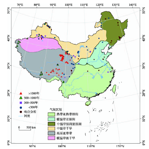
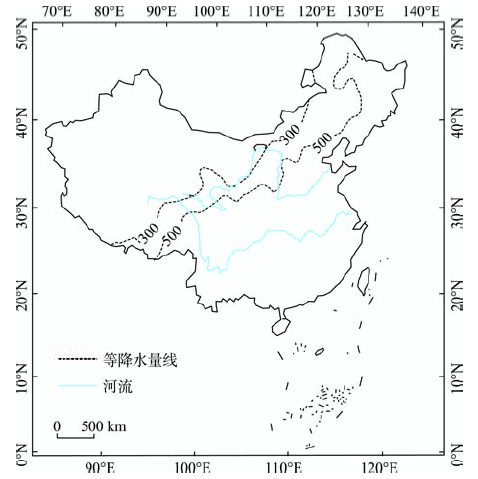