塔娜 , 柴彦威, 关美宝
Ta na, CHAI Yanwei, KWAN Mei-Po
通讯作者:
收稿日期: 2014-11-4
修回日期: 2015-04-22
网络出版日期: 2015-10-20
版权声明: 2015 《地理学报》编辑部 本文是开放获取期刊文献,在以下情况下可以自由使用:学术研究、学术交流、科研教学等,但不允许用于商业目的.
基金资助:
作者简介:
作者简介:塔娜(1986-), 女, 内蒙古包头人, 博士后, 主要研究方向为城市社会地理学与行为地理学。E-mail: tanapku@gmail.com
展开
摘要
郊区化导致的汽车出行增加及相关的城市环境与社会问题日益成为城市研究关注的焦点,但目前国内对建成环境与汽车出行行为的研究刚刚起步。基于GPS与活动日志相结合的居民一周活动与出行数据,利用GIS空间分析分别以居住地、工作地和活动空间作为地理背景,分析建成环境对于郊区居民汽车出行距离的影响因素。研究发现,建成环境对工作日汽车出行的影响因地理背景的选择而有不同。整日出行受到工作地和活动空间的影响,工作地与活动空间建设密度增高汽车出行减少,但是居住空间的影响不显著;通勤出行受到居住地、工作地和活动空间的影响,居住地商业密度提高和建设密度降低、工作地和活动空间建设密度提高,汽车出行减少;非工作活动出行也受到居住地、工作地和活动空间的影响,居住地、工作地和活动空间的公交密度低、工作地和活动空间建设密度高,汽车出行少。基于研究结果,本文对地理背景不确定性问题进行了探讨,提出出行行为的研究需要考虑居住地以外其他地理背景的影响,并对控制汽车使用的公共政策提出了建议。
关键词:
Abstract
Car use has changed daily activity travel patterns, which cause serious urban problems including air pollution, traffic congestion, road accidents, and community severance. Particularly in China's rapid suburbanization, car use and related social and environmental issues are attracting great attention. Previous research has illustrated the importance of the built environment and car ownership on daily car travel distance. However, it is still not clear how car ownership and car use impact individual behavior, and the ways researchers measure the contextual influence of the built environment are not consistent. Most of the existing literature only uses residential area as the geographic context to study the impact of built environment, and only a few studies focus on workplaces or other destinations. In recent years, the uncertain geographic context problem has come under intense scrutiny by geographers seeking to elucidate the interaction between urban space and individual behavior. According to this phenomenon of the uncertain geographic context, travel behavior is influenced not only by the origin and destinations of trips, but also by the travel routes and the surrounding activity spaces. However, so far few studies have been conducted on the impact of activity space. Based on a GPS-facilitated activity-travel survey dataset collected in the Shangdi-Qinghe area in Beijing in 2012, the present paper studies the relationship between the built environment and car travel behavior of suburban residents on weekdays. To understand the importance of geographic context, three types of geographic context are used: residential area, work location and activity space. The impact of the built environment on car travel distance in daily travel, commuting travel and non-work travel is analyzed using three sets in a linear regression model. The study finds that the impact of the built environment on car travel behavior depends on travel mode and geographic context, and the built environment in work locations and activity spaces has a larger impact on car travel distance than that in residential areas. The built environment in residential areas has an influence on daily travel distance, but lower development density and better residential accessibility in residential areas can reduce car travel distance in commuting. Higher development density in both work locations and activity spaces is related to longer car travel distance in daily life, commuting and non-work travel behavior. Contrary to the findings of Western studies, better accessibility to public transit leads to more car use in non-work travel. This paper discusses the importance of the uncertain geographic context problem, indicating that activity space plays an important role in daily activity travel behavior. These findings have key implications for policy-making decision. The built environment should be a great concern in policies aimed at car use limitation.
Keywords:
当代城市发展过程中,汽车所有权与汽车使用快速上升及其所带来的日常行为变化已经成为中西方学者共同关注的话题。1999-2009年的10年间,中国汽车所有权的上升率为每年17.2%,截止2012年底中国已经有超过1.2亿辆汽车[1]。以北京为例,2012年12月底共有注册汽车520万辆,其中超过400万辆为私家车。可以说,中国的大城市已经迈入了汽车社会的门槛,特别是对于郊区居民,汽车开始成为日常出行重要的交通方式选择[2-5]。
从国内国外的城市与交通研究发展趋势来看,新城市主义、精明增长、以及中国学者提出的新单位主义等在近年来都提出了一系列的理论概念和实证研究探讨郊区空间发展与汽车所有权增加对于居民日常活动移动行为的影响[6-7]。研究发现居住在郊区的居民需要更长的出行,特别是汽车出行,来完成各项活动以满足其个人与家庭需求[8-13]。郊区的低密度发展和单一土地利用的发展模式导致了更高的汽车拥有率和更长的汽车出行距离,居住区人口密度、零售用地与居住地的距离、职住接近、公交站点的通达性、居住区位和住房类型等都对汽车使用有重要影响[14-19]。学者提出需要通过建设高密度、混合土地利用的社区来减少汽车出行及相应的社会问题。然而,目前国内对汽车使用的影响因素的研究还很少,难以为城市规划和交通政策的制定提供理论和实证的支持。
为此,本文以北京市为例,基于GPS与活动日志相结合的居民一周活动与出行数据,分析建成环境对于郊区居民汽车出行距离的影响因素。下文将首先综述国内外相关研究成果,确定本文的分析框架;进而介绍研究区域与数据;再次进行回归分析,探讨不同地理背景下建成环境对居民汽车出行的影响;最后进行总结与讨论。
建成环境对汽车出行行为的影响是交通和城市规划研究的热点。一般来说,建成环境因素可以被总结为密度、混合度和设计三个方面[15-18, 20]。在建成环境对出行行为的影响研究中,地理背景的问题越来越成为学者关注的焦点[21]。新城市主义等研究提出,郊区居住区的建成环境导致了长距离汽车出行,试图通过建设高密度、土地混合利用的社区减少汽车出行。因此,大部分研究主要以居住地为出行行为分析的地理背景,但是学者对于居住地的定义尺度有争议,已有研究中分别采用了家庭所在的行政区域(例如人口统计单元、邮区、交通小区等)或者家庭周边一定距离内的缓冲区(例如以300 m、500 m、1000 m的步行可达范围的缓冲区)作为地理背景[22-25]。一些学者提出,有大量的非工作活动是在居住地之外进行的,因此邻里尺度和更大的邮区尺度都对汽车行为有影响[21]。
随着行为研究对于日常行为的认知加深,一些研究开始关注非居住区位的地理背景的影响,提出出行行为具有目的地效应。例如通过比较工作地和居住地的建成环境差异,学者发现工作地的密度和土地利用混合度对于交通方式选择的影响大于居住区位[26-28]。Cervero发现在工作地附近提高商业设施密度可以减少白天的出行和整日尺度的汽车使用[26]。Frank等发现出行起点和出行终点的建成环境都对交通方式选择有影响[27]。Maat等发现家庭成员工作地的区位特征对其是否使用汽车通勤具有重要影响[28]。Ding等的研究发现,居住地和工作地的人口密度、就业密度、到市中心的距离等因素对于通勤交通方式选择都有重要的影响[29]。
随着对地理背景不确定性问题的关注以及GPS、GIS技术的发展,越来越多的研究开始使用活动空间度量个体活动与出行的地理背景,讨论个体一日内所经历的城市空间整体对于个体出行行为的影响。Kwan等学者提出地理背景不确定性问题(UGCoP),认为“空间变量对个体行为作用效应的分析结果,可能受到地理背景单元或者邻里单元的划分方法及其与真实的地理背景作用空间的偏离程度的影响”[30-31]。使用居住地作为地理背景的研究结果有很大的差异,主要原因在于居住地并不能准确地展现对个体行为或经历产生影响的真实区域[32-33]。研究表明个体通过四处移动完成他们的日常活动[34-36],因此其出行方式的选择会受到其他城市空间的影响[33, 37]。研究发现个体的活动空间远大于社区的范围,在建成环境特征上具有显著差异[38-40],活动空间内部的设施密度会影响个体的出行方式选择[39, 41]。但是目前研究对于活动空间如何影响个体的汽车出行选择尚不清楚。
综述上述研究,建成环境对汽车出行的影响受到地理背景的限制,但是现有研究往往着重于居住地的影响,而对于工作地和活动空间范围内的关注比较少,本文从不同地理背景的角度对这一问题进行分析。
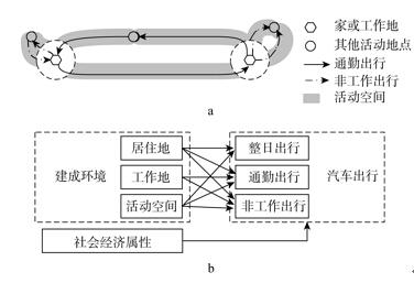
建成环境的地理背景主要考虑居住地、工作地和活动空间三个方面(图1a)。从单次出行的角度考虑,居住地周边的建成环境主要影响通勤和以家为起止点的非工作出行,工作地周边的建成环境主要影响通勤和以工作地为起止点的非工作出行,而活动空间对于整日的出行行为都可能产生影响。但是已有研究中主要考虑了居住地的影响,而工作地和活动空间的影响分析不足,特别是活动空间建成环境对汽车出行的影响还没有开展实证的研究。因此,本文希望能够通过对不同地理背景的分析,特别是引入活动空间的分析,丰富出行行为的研究。
根据已有文献,本文的概念框架如图1b所示,建成环境和社会经济属性共同影响汽车出行行为。考虑不同地理背景的意义,文章提出三个假设。首先,居民一日的出行决策、特别是以家为原点的通勤活动和部分非工作活动受到居住地周边建成环境的影响,居住地周边高密度、混合土地利用能够减少汽车使用。其次,工作日居民的工作活动形成了日常生活的强时空制约,工作地周边建成环境良好有利于居民形成复杂通勤链和就近完成其他日常需求,工作地周边高密度和混合利用发展能够减少通勤和非工作活动的汽车出行。再次,活动空间中的高密度和混合利用发展能够在沿途提供更多的活动机会,例如通勤路途中进行非工作活动,减少冗余出行,另外活动空间中道路网密集、公共交通良好可以减少汽车出行选择,因此活动空间对整日出行、通勤出行和非工作出行都有影响。
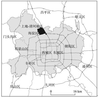
选取北京市郊区的上地—清河地区作为研究案例。北京市近年来的汽车保有量快速增长,从2007年的312万辆增长到2012年的520万辆,其中私人汽车拥有量增长了183万辆达到420万辆,私人汽车拥有量年平均增长率为18.4%;虽然2011年开始实施机动车牌照摇号配置政策后,机动车增长率有所下降,私人汽车年平均净增3.6%,但是总量依旧处于上升趋势[42]。2012年北京市城六区内工作日私人汽车平均出行次数2.70次[42]。可以说,小汽车已经成为北京市民日常出行的主要交通方式。而汽车使用的增加也带来了严重的交通拥堵等问题,例如2012年北京市早高峰时期的汽车平均速度只有26 km/h[42]。从交通政策来说,北京市一直致力于限制小汽车使用,以改善城市交通状况。可以说,北京市的汽车出行问题在全国具有代表性,对其汽车出行的研究有利于深化学界与规划领域对于汽车出行问题的认识。
案例地区位于北京市海淀区中东部、北五环与北六环之间,共约16 km2,常住人口约24万、就业人口约14万,是北京西北部大型综合性边缘组团(图2)。从区位条件及交通条件看,上地—清河地区位于北京市的五环外围,过境的高速公路、城铁将上地—清河地区与邻近的城市功能组团(如中关村城市就业中心、回龙观巨型社区等)以及中心城区相连,交通状况复杂,交通出行方式多样;从住房类型及职能方面看,上地—清河地区覆盖了传统工业区、新兴产业开发区以及单位社区、政策性住房社区、商品房社区、城中村等多种建设年代和开发模式的居住区,代表了快速郊区化地区的典型特征,人口构成多样。该地区是北京市快速发展的郊区地域之一,由于具有就业中心和居住组团的双重职能,又地处交通要道,汽车出行与交通拥堵问题一直以来都是该地区面临的重要问题。因此,研究建成环境对汽车出行的影响具有重要的意义。
数据来源于2012年9-12月间在北京上地—清河地区实施的北京居民日常活动与交通出行调查的第一手资料。调查对上地—清河地区除城中村、部队大院外的23个社区以及上地信息产业基地19个典型企业进行抽样,采用位置感知设备、互动式调查网站、面对面及电话访谈相结合的方法。其中按照社区人口0.5%~1%的比例,通过社区居委会选取543个样本,每个样本的调查时间为一周,调查内容包括居民的社会经济属性、居民一周的活动日志及GPS轨迹。最终有效样本为480个社区样本。
选取在上地—清河地区居住的有正式就业的年龄在20~60岁之间的居民样本。将活动日志数据与GPS轨迹在ArcGIS 10.2中进行关联,选择活动日志完整、轨迹质量较好的样本共293名作为本文的基础数据库,有效样本基本情况如表1。调查样本中女性略多于男性,平均年龄为36.17岁;86.69%的居民有北京户口,85%以上的居民拥有大专或以上学历;61%的居民月收入在2001~6000元之间,约30%的居民月收入高于6001元;86.69%的居民拥有自己的住房,63.14%的居民家中有小汽车,48.56%的居民拥有驾照。平均家庭规模为3.16,约50%的家庭为三口之家。
表1 被调查者社会经济属性
Tab.1 Respondent characteristics by community
| 变量 | 样本数 | 频率(%) | |
|---|---|---|---|
| 性别 | 男性 | 140 | 47.78 |
| 女性 | 153 | 52.22 | |
| 年龄 | 36.17 | ||
| 户口 | 非北京户口 | 39 | 13.31 |
| 北京户口 | 254 | 86.69 | |
| 个人月收入 | 低于2000元 | 32 | 10.92 |
| 2001~6000元 | 180 | 61.43 | |
| 6001元以上 | 81 | 27.65 | |
| 教育程度 | 高中及以下 | 42 | 14.33 |
| 大专或大学 | 199 | 67.92 | |
| 研究生及以上 | 52 | 17.75 | |
| 住房产权 | 自有住房 | 254 | 86.69 |
| 租住住房 | 39 | 13.31 | |
| 汽车所有权 | 有小汽车 | 185 | 63.14 |
| 无小汽车 | 108 | 36.86 | |
| 驾照 | 有驾照 | 142 | 48.56 |
| 无驾照 | 151 | 51.54 | |
| 家庭规模 | 1 | 5 | 1.71 |
| 2 | 68 | 23.21 | |
| 3 | 141 | 48.12 | |
| 4+ | 79 | 26.96 | |
郊区居民工作日平均汽车出行距离为10.48 km,其中通勤为5.09 km,通勤出行中汽车出行距离比为33%,非工作出行为39%。为分析建成环境对活动空间的影响,本文对居民工作日的汽车出行距离构建了线性回归模型。
模型在控制居民社会经济属性的同时,重点考察不同地理背景下建成环境特征的影响。居民社会经济属性包括性别、年龄、住房所有权、教育水平、个人收入、家庭规模、户口及其是否拥有汽车和驾照。
建成环境属性作为重点考察的自变量,结合本文的研究问题和数据特征在居住地、工作地和活动空间三个空间单元进行地理背景的测度。在综合考虑居住地和工作地的不同空间尺度和分区类型后,居住地和工作地分别采用以家庭地址和工作地地址为圆心、500 m为半径的同心圆作为地理背景范围。选择500 m同心圆的原因主要是:① 根据上地—清河地区的空间尺度,保证居住地属性的差异性;② 表现居住地和工作地周边步行可达范围内的微环境特征[43]。活动空间在ArcGIS 10.2中利用缓冲区分析,构建GPS轨迹的500 m缓冲区范围作为地理背景范围,进行个体活动空间的刻画。对于建成环境影响因素,分别采用居住地、工作地和活动空间内部的公交站密度、零售商业设施密度、建设密度和停车场密度。
公交站密度用以衡量公交便捷性,研究认为公共交通发展良好能够减少汽车出行,采用地理背景内部的公交站点数量除以地理背景的面积1(数据来源:Beijing City Lab, 2014, Data 18, Bus routes and stops of Beijing, http://www.beijingcitylab.com)。零售商业设施密度用以衡量多样性特征[43],研究假设商业设施密度高能够减少居民的非工作出行。建设密度用以衡量密度特征[20],采用地理背景内部的兴趣点(point of interest, POI)的数量进行计算1(数据来源:Beijing City Lab, 2013, Data 15, 15 Parcel maps for 297 Chinese cities, http://www.beijingcitylab.com)。停车场密度用以衡量停车的便捷程度,采用地理背景内部的停车场数量进行计算。
表2 建成环境对北京市居民整日汽车出行距离的影响的回归模型
Tab. 2 Regression model on the impact of built environment on daily car travel distance in Beijing
| 模型1:居住地属性 | 模型2:居住地+工作地 | 模型3:居住地+活动空间 | ||||||
|---|---|---|---|---|---|---|---|---|
| 系数 | P值 | 系数 | P值 | 系数 | P值 | |||
| 女性 | -6.95 | 0.001 | -6.88 | 0.001 | -6.16 | 0.002 | ||
| 年龄 | -0.29 | 0.034 | -0.31 | 0.024 | -0.30 | 0.024 | ||
| 户口 | -3.03 | 0.283 | -3.34 | 0.238 | -2.93 | 0.292 | ||
| 驾照 | 10.92 | 0.000 | 9.89 | 0.000 | 9.24 | 0.000 | ||
| 个人收入 | -1.03 | 0.261 | -0.66 | 0.479 | -0.57 | 0.533 | ||
| 教育水平 | 1.81 | 0.332 | 1.70 | 0.358 | 1.63 | 0.371 | ||
| 住房所有权 | 3.57 | 0.215 | 3.99 | 0.171 | 3.05 | 0.280 | ||
| 家庭规模 | -1.75 | 0.168 | -1.80 | 0.156 | -1.38 | 0.269 | ||
| 汽车所有权 | 6.09 | 0.009 | 6.79 | 0.004 | 5.67 | 0.013 | ||
| 居住地公交密度 | 0.10 | 0.363 | 0.13 | 0.245 | 0.12 | 0.275 | ||
| 居住地零售商业密度 | -0.06 | 0.772 | 0.03 | 0.890 | -0.08 | 0.695 | ||
| 居住地停车场密度 | -0.04 | 0.866 | -0.12 | 0.615 | -0.16 | 0.547 | ||
| 居住地建设密度 | 0.02 | 0.490 | 0.02 | 0.494 | 0.03 | 0.305 | ||
| 工作地公交站密度 | 0.13 | 0.160 | ||||||
| 工作地零售商业密度 | 0.10 | 0.403 | ||||||
| 工作地停车场密度 | -0.03 | 0.855 | ||||||
| 工作地建设密度 | -0.03 | 0.007 | ||||||
| 活动空间公交站密度 | -0.09 | 0.795 | ||||||
| 活动空间零售商业密度 | 0.44 | 0.405 | ||||||
| 活动空间停车场密度 | 0.31 | 0.640 | ||||||
| 活动空间建设密度 | -0.11 | 0.002 | ||||||
| 截距 | 17.52 | 0.061 | 16.47 | 0.082 | 27.05 | 0.011 | ||
| R2 | 0.2567 | 0.2839 | 0.3055 | |||||
表2分析了建成环境对工作日整日汽车出行距离的影响。建成环境中居住地属性对于整日汽车出行没有显著影响。这与西方已有研究的结论不符[25],但是王丰龙等对北京的研究得到了与本文类似的结论,他们发现居住地周边建成环境对小汽车出行时长没有显著影响[19]。这可能是来自于两方面的原因,第一,居民汽车出行不仅受到微观环境的影响,也受到居住区域大环境的影响[44]。第二,居民整日出行中不仅要考虑居住地的建成环境,更要考虑一天的活动安排,居住地仅是居民日常活动空间的很小一部分[30-31],从模型2和模型3中可以看到工作地和活动空间属性对居民整日汽车出行距离有显著影响。工作地和活动空间的建设密度提高居民汽车出行距离减少。首先,居民工作地的日常活动受到工作活动的制约,因此在居民整日出行活动交通方式选择中需要考虑工作地的建成环境因素,在高密度地区工作一方面方便近距离进行非工作活动[26],另一方面受到交通拥堵等因素的影响也会减少居民的汽车出行。其次,活动空间内部密度提高,提供了更多的城市机会供居民沿途进行活动,减少冗余出行,同时沿途密度高会增加交通拥堵的风险而减少居民的汽车出行。
表3 建成环境对北京市居民通勤汽车出行距离的影响的回归模型
Tab. 3 Regression model on the impact of built environment on car travel distance in commuting in Beijing
| 模型1:居住地属性 | 模型2:居住地+工作地 | 模型3:居住地+活动空间 | ||||||
|---|---|---|---|---|---|---|---|---|
| 系数 | P值 | 系数 | P值 | 系数 | P值 | |||
| 女性 | -4.04 | 0.001 | -3.83 | 0.003 | -3.77 | 0.003 | ||
| 年龄 | -0.09 | 0.298 | -0.10 | 0.275 | -0.10 | 0.241 | ||
| 户口 | 0.21 | 0.906 | -0.05 | 0.980 | 0.11 | 0.950 | ||
| 驾照 | 5.07 | 0.000 | 4.67 | 0.002 | 4.46 | 0.002 | ||
| 个人收入 | -0.55 | 0.348 | -0.32 | 0.592 | -0.42 | 0.473 | ||
| 教育水平 | -0.12 | 0.926 | -0.10 | 0.936 | -0.06 | 0.962 | ||
| 住房所有权 | 2.25 | 0.220 | 2.10 | 0.264 | 1.92 | 0.292 | ||
| 家庭规模 | -0.29 | 0.718 | -0.18 | 0.820 | -0.10 | 0.904 | ||
| 汽车所有权 | 2.24 | 0.132 | 2.46 | 0.105 | 2.13 | 0.149 | ||
| 居住地公交密度 | 0.00 | 0.970 | 0.01 | 0.841 | 0.03 | 0.686 | ||
| 居住地零售商业密度 | -0.26 | 0.042 | -0.23 | 0.082 | -0.30 | 0.026 | ||
| 居住地停车场密度 | -0.02 | 0.876 | -0.06 | 0.699 | -0.05 | 0.769 | ||
| 居住地建设密度 | 0.04 | 0.012 | 0.04 | 0.011 | 0.05 | 0.006 | ||
| 工作地公交站密度 | 0.04 | 0.471 | ||||||
| 工作地零售商业密度 | 0.04 | 0.603 | ||||||
| 工作地停车场密度 | 0.00 | 0.983 | ||||||
| 工作地建设密度 | -0.01 | 0.018 | ||||||
| 活动空间公交站密度 | -0.21 | 0.327 | ||||||
| 活动空间零售商业密度 | 0.30 | 0.409 | ||||||
| 活动空间停车场密度 | 0.14 | 0.748 | ||||||
| 活动空间建设密度 | -0.05 | 0.064 | ||||||
| 截距 | 6.08 | 0.309 | 5.63 | 0.359 | 12.11 | 0.074 | ||
| R2 | 0.195 | 0.2162 | 0.2285 | |||||
表3分析了建成环境对居民通勤汽车出行距离的影响。居住地周边的零售商业密度提高,通勤汽车出行减少。零售商业密度衡量了居住区的多样性特征,已有研究表明,居住地周边零售商业可达性好工作出行汽车使用减少[16, 45]。另外,这也与中国城市的特殊性有关,居住地周边500 m内的商业一般以楼房底商、便民市场或小商业街的形式出现,在单位等老旧社区周边的比例一般比较高,而这些社区土地混合利用、职住接近等特征导致汽车通勤较少。但是居住地周边的建设密度提高,通勤汽车出行距离反而提高。这与西方已有研究不符[45]。与整日出行类似,工作地周边和活动空间的建设密度高,汽车通勤出行距离减少。
表4 建成环境对北京市居民非工作活动的汽车出行距离的影响的回归模型
Tab. 4 Regression model on the impact of built environment on car travel distance in non-work activities in Beijing
| 模型1:居住地属性 | 模型2:居住地+工作地 | 模型3:居住地+活动空间 | ||||||
|---|---|---|---|---|---|---|---|---|
| 系数 | P值 | 系数 | P值 | 系数 | P值 | |||
| 女性 | -5.18 | 0.006 | -5.66 | 0.003 | -4.73 | 0.011 | ||
| 年龄 | -0.14 | 0.252 | -0.15 | 0.238 | -0.10 | 0.430 | ||
| 户口 | -6.72 | 0.012 | -6.80 | 0.012 | -6.55 | 0.013 | ||
| 驾照 | 4.31 | 0.040 | 3.63 | 0.092 | 4.06 | 0.049 | ||
| 个人收入 | -1.44 | 0.116 | -1.38 | 0.129 | -1.49 | 0.098 | ||
| 教育水平 | 2.48 | 0.158 | 3.03 | 0.086 | 3.28 | 0.062 | ||
| 住房所有权 | 2.74 | 0.311 | 3.19 | 0.254 | 2.02 | 0.451 | ||
| 家庭规模 | -0.78 | 0.508 | -0.83 | 0.482 | -0.84 | 0.467 | ||
| 汽车所有权 | 4.66 | 0.036 | 4.92 | 0.030 | 4.21 | 0.054 | ||
| 居住地公交站密度 | 0.22 | 0.032 | 0.23 | 0.020 | 0.19 | 0.069 | ||
| 居住地零售商业密度 | 0.31 | 0.121 | 0.35 | 0.080 | 0.26 | 0.216 | ||
| 居住地停车场密度 | -0.08 | 0.703 | -0.17 | 0.443 | -0.11 | 0.645 | ||
| 居住地建设密度 | -0.04 | 0.127 | -0.05 | 0.103 | -0.04 | 0.122 | ||
| 工作地公交站密度 | 0.14 | 0.089 | ||||||
| 工作地零售商业密度 | 0.13 | 0.282 | ||||||
| 工作地停车场密度 | 0.08 | 0.600 | ||||||
| 工作地建设密度 | -0.02 | 0.070 | ||||||
| 活动空间公交站密度 | 0.72 | 0.033 | ||||||
| 活动空间零售商业密度 | 0.71 | 0.189 | ||||||
| 活动空间停车场密度 | -0.26 | 0.687 | ||||||
| 活动空间建设密度 | -0.10 | 0.005 | ||||||
| 截距 | 15.50 | 0.086 | 12.35 | 0.181 | 11.15 | 0.253 | ||
| R2 | 0.2806 | 0.324 | 0.329 | |||||
表4分析了建成环境对居民非工作汽车出行的影响。居住地周边的公交站密度高,非工作汽车出行增加。这与已有研究不符[19]。可能的解释是,从中国城市的空间发展看,路网建设与公共交通分布是相关的,公交分布较好的地区路网建设往往也比较好,例如上地—清河地区公交站点分布与路网密度呈显著正相关(相关系数0.444)。而公交出行受到时间、拥挤等影响严重,郊区居民的汽车出行受到偏好的影响比较大,在公交和汽车可以同时选择时,长距离出行会偏向于选择汽车出行。但是由于本次调查没有涉及偏好等因素,这一结果的深层次的原因还有待进一步的研究进行剖析。工作地周边建设密度提高非工作汽车出行减少,而公交站密度提高非工作汽车出行增加。分析工作地与非工作活动的关系,约38%的购物活动、46%的休闲活动和59%的外出就餐活动以工作地为起点,由此可见,工作日郊区居民的家外非工作活动中工作地作为出行起点起到了十分重要的作用。工作地是一个重要的锚点,因此工作地周边土地利用密度会影响居民对于这些活动的交通方式选择。活动空间内公交站密度提高非工作汽车出行增加,建设密度提高汽车出行减少。结果再一次证明活动空间内部的建设密度提高有利于减少汽车出行,印证了Kwan等学者对于地理背景不确定性的观点,即活动空间背景对日常出行具有重要的影响[30-31]。
本文基于GPS与活动日志相结合的北京市上地—清河地区居民一周活动与出行数据,基于居住地、工作地和活动空间,研究建成环境对于郊区居民汽车出行的影响。基于回归分析,研究发现建成环境对汽车出行距离的影响受到地理背景的影响。具体来说:整日出行受到工作地和活动空间的影响,工作地与活动空间建设密度增高汽车出行减少,但是居住空间对整日出行影响不显著。通勤出行受到居住地、工作地和活动空间的影响,居住地商业密度提高和建设密度降低、工作地和活动空间建设密度提高,汽车出行减少。非工作活动也受到居住地、工作地和活动空间的影响,三类地理背景的公交密度低、工作地和活动空间建设密度高,汽车出行减少。总体而言,居住郊区化主要影响通勤和非工作出行,提高工作地和活动空间内的土地利用集约度和混合度有利于减少汽车出行,但是与西方研究不同,公交高密度反而会增加非工作活动的汽车出行。
本文的研究结果对地理背景的不确定性问题提供了实证支持,提出活动空间对出行行为具有重要影响,以往仅考虑居住环境的出行行为分析需要增加其他地理背景的考虑。首先,GIS与GPS技术对解决UGCoP确实有很大的作用,通过收集与分析人们的活动数据与环境影响的时空动态数据构建活动空间,可以更好的描述个体活动的真实空间信息[20-21, 37]。其次,居住地、工作地和活动空间对于个体日常汽车出行的影响具有差异,活动空间建成环境的信息对于不同类型的汽车出行的都有较好的解释力。这是由于居住地仅是个体一日活动空间的一小部分,而且并非所有出行行为都是以家为出发地的。因此,其他活动地点具有的“目的地效应”和出行轨迹的“路径效应”都有可能影响“邻里效应”的作用效果。本文的研究结果指出,行为研究应当注重基于个体的测量,即使是居住在同一社区的人,由于其他活动的差别,每个人的环境背景单元也具有很大的差异性。
本文对控制汽车使用也有重要的意义。第一,控制汽车出行应当重视空间规划和土地利用相关政策,通过改变土地利用模式减少汽车出行,特别要注意主要就业中心、副中心的建设密度和混合度,通过改变居民出行目的地的土地利用模式减少汽车出行。第二,不同地理背景和不同出行目的的汽车使用有差别,只有考虑不同类型出行活动中的汽车使用的差异性,针对性地制定城市交通管理措施,才能真正有效控制汽车的使用强度。
本文也有一些不足需要提升。首先,未考虑自选择现象的影响。曹新宇等学者研究发现居民的汽车出行可能是一种自我选择的结果[22],即喜欢汽车出行的人居住在适合开车的环境中。这种自我选择不仅限于居住地,居民的工作地和整日活动的路径都可能受到偏好的影响。由于数据限制,本文未能考虑居民的自我选择,未来需要新的数据支持进行深入研究。其次,采用截面数据和线性回归模型,在分析影响因素的因果关系时存在一定的局限。
The authors have declared that no competing interests exist.
| [1] |
Managing urban growth to reduce motorised travel in Beijing: One method of creating a low-carbon city .https://doi.org/10.1080/09640568.2010.547684 URL [本文引用: 1] 摘要
The environmental impact of rising motorised travel has become a key issue regarding low-carbon development in China. Drastic urban expansion under the current rapid urbanisation process tends to worsen these impacts. This paper examines the impacts of the patterns of urban development on motorised travel in the case of Beijing. By using household survey data, the analysis finds that the patterns of urban development on the urban fringe have a significant impact on workers' car use for their journeys to work when their socio-economic characteristics, household preferences for housing location and level of public transport accessibility are taken into account. Sprawling industrial and real estate development, characterised by a low degree of self-contained development and low-density land use, tends to increase the need to drive. The findings suggest that growth management to control sprawling development would play an important role in containing the motorised travel demand in China where transport policies are usually focused on huge and expensive transport projects. Urban growth management can have significant implications for achieving the objectives of creating a low-carbon city in China in the current process of rapid urbanisation.
|
| [2] |
Urban transportation in Shanghai, China: Problems and planning implications .https://doi.org/10.1111/1468-2427.00103 URL [本文引用: 1] 摘要
Traffic congestion and transit service deterioration are becoming acute problems in China’s major cities. Based on a case study of Shanghai, this paper examines the growing gap between the supply of urban transportation facilities and the demand for travel, and discusses the planning implications. Because it will take great amounts of time and resources to transform the municipal transportation infrastructure into one suitable for high level mobility and motorization, the supply side is constrained for the short term. Therefore, planning research is directed primarily to the demand side. Transportation surveys indicate that travel demand has been increasing explosively through a combination of more trips, longer trips, and mode shifts away from walk and transit. Population growth, growth of family income, urban expansion and spatial reconfiguration, the emergence of labor and housing markets, and motorization are identified as the main causal factors. The probable future effects of these factors are analyzed and policy options are explored. The paper argues that enhancing accessibility without inducing mobility should be a basic guideline for policy-making and urban planning. Given the fast pace of urban development and the important role of the municipal government in locating urban activities, land-use planning can be a highly effective means for improving accessibility. Specific land-use strategies and complementary policies are proposed. Since Shanghai is in some important ways representative of large metropolises in the developing world, the case study is potentially valuable for other cities as well. Les embouteillages et la détérioration des services de transport deviennent des problèmes graves dans les villes importantes de Chine. Basé sur une étude de cas de Shangaï谋, cet article examine le décalage grandissant entre la demande et la provision des moyens de transport, et discute les implications pour la planification. La transformation de l’infrastructure des transports municipaux afin qu'elle se prête à la mobilité et motorisation de haut niveau demandera un temps et des ressources considérables, et conséquemment l’approvisionnement est limité dans l'immédiat. La recherche sur la planification se concentre donc principalement sur la demande. Les sondages sur les transports indiquent que la demande de transport a beaucoup augmentéà cause d’une conjonction
|
| [3] |
Private motorised urban mobility in China's large cities: The social causes of change and an agenda for future research .https://doi.org/10.1016/j.jtrangeo.2014.07.011 URL 摘要
The growth of private motorised urban mobility has become a key issue in relation to environmental quality in China’s cities. This paper reports on a nationwide study of the changes in car use in the 2000s, conducted in eleven large cities. This may assist us in filling the gaps in our existing knowledge, which is based on individual city cases. It is apparent that China’s large cities are embracing a new era of the automobile at an unexpected speed and scale. However, at the same time, it seems that a ‘peak’ in car use has occurred in Shanghai and Beijing, as either the absolute number of VKT per capita has dropped or its growth has slowed in these cities. The changes in urban mobility are deeply affected by social and economic transition factors. The paper provides an in-depth analysis of the effects of increasing incomes and the growing middle class, changing lifestyles and the emerging consumer society, the appearance of the e-Society and an increasingly ageing society. In particular, the growing demand for car use by the younger generation (G2), women and elderly people for the purpose of social activity has become an important force behind the increase in overall VKT. The paper concludes with a discussion of current theoretical perspectives and the issues which should be addressed in future research on the social aspects of private motorised urban mobility in China.
|
| [4] |
The spatio-temporal variations of urban private car ownership in China and their influencing factors .
选取中国235 个地级以上城市为样本,研究了1990-2009 年中国城市私人汽车拥有量演变的时空特征,并选取了9 个解释变量,使用1995-2009 年的面板数据,建立面板数据模型量化各影响因素的贡献率,分析各因素对城市私人汽车拥有量的作用机制。研究结果表明:① 中国城市私人汽车的发展呈现出一定的阶段性特点,并具有明显的空间集聚及区域分异特征;② 中国城市私人汽车发展的空间差异呈先增大后缩小的倒“U”形变动轨迹;2000 年后,中国城市私人汽车发展的空间差异出现了地带间趋异而地带内趋同的现象;③ 经济因素是私人汽车拥有量的决定性因素,私人汽车拥有量随人均收入的发展呈现出“S”形增长,城市化水平对私人汽车拥有量具有显著正效应,但对特大及巨大城市却产生了不显著的负效应;④ 城市空间扩张带来的城市规模增加会导致城市私人交通工具使用需求增大,当城市人口规模达到一定的临界值以上后,城市人口密度的增加能抑制私人汽车拥有量的增加;⑤ 城市公共交通及出租车的服务能力对私人汽车的增长有抑制作用,但并不显著,且随着城市规模的扩大,城市公共交通发展对私人汽车增长的抑制作用逐渐增强。
中国城市私人汽车发展的时空特征及影响因素 .
选取中国235 个地级以上城市为样本,研究了1990-2009 年中国城市私人汽车拥有量演变的时空特征,并选取了9 个解释变量,使用1995-2009 年的面板数据,建立面板数据模型量化各影响因素的贡献率,分析各因素对城市私人汽车拥有量的作用机制。研究结果表明:① 中国城市私人汽车的发展呈现出一定的阶段性特点,并具有明显的空间集聚及区域分异特征;② 中国城市私人汽车发展的空间差异呈先增大后缩小的倒“U”形变动轨迹;2000 年后,中国城市私人汽车发展的空间差异出现了地带间趋异而地带内趋同的现象;③ 经济因素是私人汽车拥有量的决定性因素,私人汽车拥有量随人均收入的发展呈现出“S”形增长,城市化水平对私人汽车拥有量具有显著正效应,但对特大及巨大城市却产生了不显著的负效应;④ 城市空间扩张带来的城市规模增加会导致城市私人交通工具使用需求增大,当城市人口规模达到一定的临界值以上后,城市人口密度的增加能抑制私人汽车拥有量的增加;⑤ 城市公共交通及出租车的服务能力对私人汽车的增长有抑制作用,但并不显著,且随着城市规模的扩大,城市公共交通发展对私人汽车增长的抑制作用逐渐增强。
|
| [5] |
Private cars and development of urban form and structure .https://doi.org/10.3969/j.issn.1009-6000.2008.07.012 URL [本文引用: 1] 摘要
城市交通系统的发展有助于塑造城市形态,改变城市的空间结构,城市主导地位的交通方式决定着城市形态与城市空间结构的发展演化.西方发达国家小汽车交通的 发展及对城市空间的影响趋于稳定状态,小汽车交通与城市空间发展相对匹配.中国从20世纪90年代开始城市小汽车交通的大规模发展,对城市空间形态和城市 结构造成巨大影响,这种影响将在未来较长一段时期内体现在城市空间发展方面,对城市规划和交通规划提出了新的挑战.
小汽车交通与城市空间发展 .https://doi.org/10.3969/j.issn.1009-6000.2008.07.012 URL [本文引用: 1] 摘要
城市交通系统的发展有助于塑造城市形态,改变城市的空间结构,城市主导地位的交通方式决定着城市形态与城市空间结构的发展演化.西方发达国家小汽车交通的 发展及对城市空间的影响趋于稳定状态,小汽车交通与城市空间发展相对匹配.中国从20世纪90年代开始城市小汽车交通的大规模发展,对城市空间形态和城市 结构造成巨大影响,这种影响将在未来较长一段时期内体现在城市空间发展方面,对城市规划和交通规划提出了新的挑战.
|
| [6] |
Smart growth and the transportation-land use connection: What does the research tell us? https://doi.org/10.1177/0160017604273626 URL [本文引用: 1] 摘要
The connection between transportation and land use lies at the center of efforts in the United States to combat sprawl through smart growth strategies. Proponents of smart growth commonly make several specific propositions about the relationships between transportation and land use: (1) building more highways will contribute to more sprawl, (2) building more highways will lead to more driving, (3) investing in light rail transit systems will increase densities, and (4) adopting new urbanism design strategies will reduce automobile use. This article explores how well the available evidence supports these four propositions and provides an overview of the theory, research efforts, and current debates associated with each of these propositions. This overview shows that the four propositions have not yet been fully resolved: researchers have made more progress on some of these propositions than others, but even in the best cases, our ability to predict the impact of smart growth policies remains limited.
|
| [7] |
https://doi.org/10.3969/j.issn.1000-3363.2011.06.005 URL [本文引用: 1] 摘要
立足于中国城市空间的转型分 析,从单位视角系统梳理了市场化转型和去单位化的过程和制度因素;在此基础上,结合"十二五"规划,分析了城市空间社会化转型的低碳、公平和生活质量等前 沿面向,呼吁城市规划在环境保护、社会公共和生活服务等方面的政策化转型和价值回归。最后,从城市空间组织模式转型和"再单位化"的角度,借鉴单位的空间 组织思想,概要阐述了新单位主义的空间思想,以期开拓面向未来30年城市规划和城市空间发展转型的城市空间组织理论。
https://doi.org/10.3969/j.issn.1000-3363.2011.06.005 URL [本文引用: 1] 摘要
立足于中国城市空间的转型分 析,从单位视角系统梳理了市场化转型和去单位化的过程和制度因素;在此基础上,结合"十二五"规划,分析了城市空间社会化转型的低碳、公平和生活质量等前 沿面向,呼吁城市规划在环境保护、社会公共和生活服务等方面的政策化转型和价值回归。最后,从城市空间组织模式转型和"再单位化"的角度,借鉴单位的空间 组织思想,概要阐述了新单位主义的空间思想,以期开拓面向未来30年城市规划和城市空间发展转型的城市空间组织理论。
|
| [8] |
Urban form and household activity-travel behavior .https://doi.org/10.1111/j.1468-2257.2006.00314.x URL [本文引用: 1] 摘要
Cities and metropolitan regions face several challenges including urban sprawl, auto dependence and congestion, and related environmental and human health effects. Examining the spatial characteristics of daily household activity-travel behavior holds important implications for understanding and addressing urban transportation issues. Research of this sort can inform development of urban land use policy that encourages the use of local opportunities, potentially leading to reduced motorized travel. This article examines the potential household activity-travel response to a planned metropolitan polycentric hierarchy of activity centers. Behavioral observations have been drawn from an activity-travel survey conducted in the Portland, Oregon, metropolitan area during the mid-1990s. Evidence presented from exploratory analysis indicates an urban/suburban differential, with less daily travel and smaller activity spaces for urban households. Investigation of the travel reduction potential of the proposed land-use strategy suggests that location effects could be offset by adjustments to household sociodemographic and mobility characteristics. Copyright 2006 Blackwell Publishing.
|
| [9] |
Activity spaces: Measures of social exclusion? https://doi.org/10.1016/j.tranpol.2003.07.002 URL 摘要
The paper provides a first investigation of the suitability of different measures of activity space size to identify persons at risk of social exclusion. This would be a new departure for the measurement of social exclusion, which so far has relied either on aggregate measures of locations or cross-sectional data of individuals.The size of a person's activity space can only be estimated with information reflecting a longer time horizon. In this paper the six-week travel diary survey (Mobi) is used, which was conducted in two German cities in 1999. About 95% of all local trips were coded for 300 respondents (about 45,000 trips).The paper develops three possible measurement approaches of increasing complexity (confidence ellipse, kernel density estimates, shortest paths networks). The analysis revealed that the main driver of the size of the activity spaces is the overall number of unique locations visited by the respondents and to a lesser extent, their socio-demographic characteristics. In particular, the groups most often consider to be at risk of social exclusion (female, lower income, elderly) did not show significantly different activity spaces.
|
| [10] |
https://doi.org/10.3969/j.issn.1006-3862.2010.01.007 URL 摘要
本文首先分析了我国快速城市化 过程中所面临的资源和环境问题的挑战。指出在这一发展过程中必须对城市的交通和土地使用发展模式进行必要的控制。并以上海为例分析了城市交通政策、土地使 用控制对延缓个人机动化快速发展的作用,及轨道交通建设与可持续发展的关系,指出多模式交通体系的重要性,最后提出了有利于建设具有我国特点的低碳城市的 城市交通与土地使用的5D模式,并对在规划实践中如何实现面向低碳的城市空间结构提出了一些建议。
https://doi.org/10.3969/j.issn.1006-3862.2010.01.007 URL 摘要
本文首先分析了我国快速城市化 过程中所面临的资源和环境问题的挑战。指出在这一发展过程中必须对城市的交通和土地使用发展模式进行必要的控制。并以上海为例分析了城市交通政策、土地使 用控制对延缓个人机动化快速发展的作用,及轨道交通建设与可持续发展的关系,指出多模式交通体系的重要性,最后提出了有利于建设具有我国特点的低碳城市的 城市交通与土地使用的5D模式,并对在规划实践中如何实现面向低碳的城市空间结构提出了一些建议。
|
| [11] |
https://doi.org/10.3969/j.issn.1000-3363.2011.05.008 URL 摘要
世界范围内关于土地使用对出行 影响的研究越来越多,但是由于土地使用和出行关系的复杂性,以及研究者采用的方法、数据等的差异,土地使用是否影响出行、土地使用要素如何影响出行目前没 有明确的结论。现对近年来土地使用对出行影响研究的分类、关键要素、分析框架、理论分析模型等进行梳理和归纳,旨在明确各种方法的优势和不足,进而提出了 目前研究中存在的问题和面临的挑战,为今后的研究提供借鉴。
https://doi.org/10.3969/j.issn.1000-3363.2011.05.008 URL 摘要
世界范围内关于土地使用对出行 影响的研究越来越多,但是由于土地使用和出行关系的复杂性,以及研究者采用的方法、数据等的差异,土地使用是否影响出行、土地使用要素如何影响出行目前没 有明确的结论。现对近年来土地使用对出行影响研究的分类、关键要素、分析框架、理论分析模型等进行梳理和归纳,旨在明确各种方法的优势和不足,进而提出了 目前研究中存在的问题和面临的挑战,为今后的研究提供借鉴。
|
| [12] |
Characteristics of commuting pattern in Beijing: Based on the comparison of different urban residential areas .
<p>改革开放以来,伴随城市土地与住房市场化改革逐渐推进、郊区化与城市空间扩张不断加快、单位制度及单位大院的解体等,北京城市内部居住与就业的空间组织正经历着显著变化,从而导致通勤问题的产生以及城市通勤格局的显著变化。本文基于对北京市内10个典型居住区中600个家庭、842位就业居民的日常通勤行为问卷调查数据,比较城市内部不同居住地域居民通勤格局的差异性,以期折射北京市居住与就业空间重构的微观过程。研究表明:(1)城市内部不同居住区居民的通勤行为存在显著差异性;(2)不同类型单位居住区通勤格局呈现出明显的分化;(3)老城区旧居住区中相当比例的长距离逆向通勤,以及郊区新建商品房以及政策性住房居住区中较高比例的长距离内向通勤,反映城市职住分离现象的出现。</p>
基于居住区比较的北京城市通勤研究 .
<p>改革开放以来,伴随城市土地与住房市场化改革逐渐推进、郊区化与城市空间扩张不断加快、单位制度及单位大院的解体等,北京城市内部居住与就业的空间组织正经历着显著变化,从而导致通勤问题的产生以及城市通勤格局的显著变化。本文基于对北京市内10个典型居住区中600个家庭、842位就业居民的日常通勤行为问卷调查数据,比较城市内部不同居住地域居民通勤格局的差异性,以期折射北京市居住与就业空间重构的微观过程。研究表明:(1)城市内部不同居住区居民的通勤行为存在显著差异性;(2)不同类型单位居住区通勤格局呈现出明显的分化;(3)老城区旧居住区中相当比例的长距离逆向通勤,以及郊区新建商品房以及政策性住房居住区中较高比例的长距离内向通勤,反映城市职住分离现象的出现。</p>
|
| [13] |
The impact of commuters' travel pattern on urban structure: A case study in some typical communities in Guangzhou .
<p>行为研究是近年来人文地理研究中颇受关注的领域之一,对微观行为进行宏观归纳,进而解释人地关系是提升其理论价值的重要方向之一。GIS的应用在很大程度上解决了研究手段上的瓶颈问题。本文将GIS与传统的研究方法相结合,构建基于智能图的微观行为调查方法体系,并利用GIS实现微观行为及空间感知的宏观空间模拟,探讨基于城市居民通勤行为分析的空间解读方法。同时,将该方法运用于广州市,选择具有典型意义的街区进行研究。通过调查,获取典型街区实体空间信息、被调查者社会属性、通勤行为空间和对通勤沿路相关实体要素的感知等信息,进行分析与模拟。一方面,分析认为,居民通勤行为空间在很大程度上反映实体空间的现状及其演化,同时,与社会空间有一定的关系;另一方面,以调查获取的数据为实验基础,利用GIS进行基于个体对实体空间感知的宏观效果模拟实验,该方法能较好地解读实体空间的特征和存在的主要问题,并具有一定的可拓展性。</p>
基于居民通勤行为分析的城市空间解读: 以广州市典型街区为案例 .
<p>行为研究是近年来人文地理研究中颇受关注的领域之一,对微观行为进行宏观归纳,进而解释人地关系是提升其理论价值的重要方向之一。GIS的应用在很大程度上解决了研究手段上的瓶颈问题。本文将GIS与传统的研究方法相结合,构建基于智能图的微观行为调查方法体系,并利用GIS实现微观行为及空间感知的宏观空间模拟,探讨基于城市居民通勤行为分析的空间解读方法。同时,将该方法运用于广州市,选择具有典型意义的街区进行研究。通过调查,获取典型街区实体空间信息、被调查者社会属性、通勤行为空间和对通勤沿路相关实体要素的感知等信息,进行分析与模拟。一方面,分析认为,居民通勤行为空间在很大程度上反映实体空间的现状及其演化,同时,与社会空间有一定的关系;另一方面,以调查获取的数据为实验基础,利用GIS进行基于个体对实体空间感知的宏观效果模拟实验,该方法能较好地解读实体空间的特征和存在的主要问题,并具有一定的可拓展性。</p>
|
| [14] |
Planned communities, self-containment and commuting: A cross-national perspective .https://doi.org/10.1080/00420989550012618 URL [本文引用: 1] 摘要
Many new towns are planned as balanced, self-contained communities. This paper examines the association between how self-contained new towns are and how their residents and workers commute, drawing upon experiences in the US, the UK, metropolitan Paris and greater Stockholm. While American new towns are fairly self-contained, their commuting characteristics are largely indistinguishable from less-planned control communities. Britain's most recent new towns are highly balanced and self-contained, yet they are comparatively auto-dependent. By contrast, the rail-served new towns outside Paris and Stockholm are the least self-contained among the new towns studied; however, most external commutes are by rail transit or other non-auto modes. In general, there was an inverse relationship between self-containment and transit commuting in the European new towns studied. The paper concludes that other policies, like coordinated transit services, more strongly influence commuting choices among new town residents and workers than initiatives aimed at jobs-housing balance and self-sufficiency.
|
| [15] |
The influence of urban form on travel: An interpretive review .https://doi.org/10.1177/08854120022092890 URL [本文引用: 1] 摘要
This article explores whether neighborhood design can improve traffic. A scheme is first proposed for categorizing research addressing this and other related issues. Next, a detailed discussion of key studies of urban form and travel behavior is presented. The research strategies employed and the data, methods, and results of these studies are then evaluated in detail. The article concludes that although this body of research is improving in several respects and should be encouraged by policymakers and scholars alike, the current understanding of this complex group of relationships remains tentative. The basis for using land use and urban design to selectively change travel behavior thus appears limited in the near term, whereas research opportunities abound.
|
| [16] |
Which reduces vehicle travel more: Jobs-housing balance or retail-housing mixing? https://doi.org/10.1080/01944360608976767 URL [本文引用: 1] 摘要
This paper investigates which land-use strategy yields the greatest reductions in vehicular travel: improving the proximity of jobs to housing, or bringing retail services closer to residential areas. Using data from the San Francisco Bay Area, the degree to which job accessibility is associated with reduced work travel is examined. In addition, the correlation of retail and service accessibility with mile sand hours spent getting to shopping destinations is probed. Findings show that the jobs-housing balance more successfully reduces travel. However, the vehicle miles traveled and vehicle hours traveled reduction elasticities for both polices were estimated to be well above zero, suggesting that pursuing both strategies could yield benefits in many settings. Local and regional initiatives to balance the growth of jobs and housing are discussed.
|
| [17] |
Measuring sprawl and its transportation impacts .https://doi.org/10.3141/1831-20 URL 摘要
Across the United States, urban sprawl, its impacts, and appropriate containment policies have become the most hotly debated issues in urban planning. Today's debates have no anchoring definition of sprawl, which has contributed to their unfocused, dogmatic quality. Efforts to measure sprawl and test for relationships between sprawl and transportation outcomes are described. This is the first use of the newly minted Rutgers-Cornell sprawl indicators. Sprawl is operationalized by combining many variables into a few factors representing density, land use mix, degree of centering, and street accessibility. This consolidation of variables is accomplished with principal component analysis. These factors are then related to vehicle ownership, commute mode choice, commute time, vehicle miles traveled per capita, traffic delay per capita, traffic fatalities per capita, and 8-h ozone level. These associations are made with multiple regression analysis. For most travel and transportation outcomes, sprawling regions perform less well than compact ones. The exceptions are average commute time and annual traffic delay per capita, which do not clearly favor compactness over sprawl. The main limitation of this study has to do with the data it uses. By necessity, the study uses highly aggregate data from a variety of sources that are not always consistent as to the area under study and time period. They are simply the best data available from national sources with sufficient breadth to provide a panoramic view of sprawl in the United States. Results will have to be validated through follow-up work of a more focused nature.
|
| [18] |
Correlation or causality between the built environment and travel behavior? Evidence from Northern California .https://doi.org/10.1016/j.trd.2005.05.002 URL [本文引用: 1] 摘要
The sprawling patterns of land development common to metropolitan areas of the US have been blamed for high levels of automobile travel, and thus for air quality problems. In response, smart growth programs09恪 designed to counter sprawl09恪県ave gained popularity in the US. Studies show that, all else equal, residents of neighborhoods with higher levels of density, land-use mix, transit accessibility, and pedestrian friendliness drive less than residents of neighborhoods with lower levels of these characteristics. These studies have shed little light, however, on the underlying direction of causality09恪眎n particular, whether neighborhood design influences travel behavior or whether travel preferences influence the choice of neighborhood. The evidence thus leaves a key question largely unanswered: if cities use land use policies to bring residents closer to destinations and provide viable alternatives to driving, will people drive less and thereby reduce emissions? Here a quasi-longitudinal design is used to investigate the relationship between neighborhood characteristics and travel behavior while
|
| [19] |
Characteristics and determinants of car use in Beijing .https://doi.org/10.11821/dlxb201406005 URL Magsci [本文引用: 3] 摘要
目前,中国城市私人汽车的拥有量高速增长,小汽车不仅日益成为居民日常出行的重要交通方式,更深刻影响着城市的空间结构和道路的拥堵状况。然而,目前国内对汽车使用的研究仍十分匮乏。为此,本文试图基于2011 年11 月到2012 年7 月在北京进行的一项问卷调查数据,分析家庭汽车使用行为的特征、强度及影响因素。描述性统计和(定序Logistic) 回归分析结果显示,汽车使用目的、建成环境和各种家庭/个人社会经济特征对大城市居民的汽车使用强度和依赖度有重要影响。其中,通勤是居民日常使用汽车的主要目的;公共交通条件较差和停车条件便利是促使居民大量使用汽车的重要原因;婚姻状态、工作状态、家庭规模和家庭内持有驾照的成员数等对居民的日常汽车使用也有重要影响;周末与工作日的汽车使用频次或时长没有显著差异。这些发现对道路交通规划和交通政策的制定有重要参考意义。不过,要想更有效地控制汽车使用行为,未来的研究仍有必要增强对因果关系、出行的限制条件和影响交通行为的心理机制等问题的考察。
北京市居民汽车使用的特征及其影响因素简 .https://doi.org/10.11821/dlxb201406005 URL Magsci [本文引用: 3] 摘要
目前,中国城市私人汽车的拥有量高速增长,小汽车不仅日益成为居民日常出行的重要交通方式,更深刻影响着城市的空间结构和道路的拥堵状况。然而,目前国内对汽车使用的研究仍十分匮乏。为此,本文试图基于2011 年11 月到2012 年7 月在北京进行的一项问卷调查数据,分析家庭汽车使用行为的特征、强度及影响因素。描述性统计和(定序Logistic) 回归分析结果显示,汽车使用目的、建成环境和各种家庭/个人社会经济特征对大城市居民的汽车使用强度和依赖度有重要影响。其中,通勤是居民日常使用汽车的主要目的;公共交通条件较差和停车条件便利是促使居民大量使用汽车的重要原因;婚姻状态、工作状态、家庭规模和家庭内持有驾照的成员数等对居民的日常汽车使用也有重要影响;周末与工作日的汽车使用频次或时长没有显著差异。这些发现对道路交通规划和交通政策的制定有重要参考意义。不过,要想更有效地控制汽车使用行为,未来的研究仍有必要增强对因果关系、出行的限制条件和影响交通行为的心理机制等问题的考察。
|
| [20] |
Travel demand and the 3Ds: Density, diversity, and design .https://doi.org/10.1016/S1361-9209(97)00009-6 URL [本文引用: 3] 摘要
The built environment is thought to influence travel demand along three principal dimensions —density, diversity, and design. This paper tests this proposition by examining how the ‘3Ds’ affect trip rates and mode choice of residents in the San Francisco Bay Area. Using 1990 travel diary data and land-use records obtained from the U.S. census, regional inventories, and field surveys, models are estimated that relate features of the built environment to variations in vehicle miles traveled per household and mode choice, mainly for non-work trips. Factor analysis is used to linearly combine variables into the density and design dimensions of the built environment. The research finds that density, land-use diversity, and pedestrian-oriented designs generally reduce trip rates and encourage non-auto travel in statistically significant ways, though their influences appear to be fairly marginal. Elasticities between variables and factors that capture the 3Ds and various measures of travel demand are generally in the 0.06 to 0.18 range, expressed in absolute terms. Compact development was found to exert the strongest influence on personal business trips. Within-neighborhood retail shops, on the other hand, were most strongly associated with mode choice for work trips. And while a factor capturing ‘walking quality’ was only moderately related to mode choice for non-work trips, those living in neighborhoods with grid-iron street designs and restricted commercial parking were nonetheless found to average significantly less vehicle miles of travel and rely less on single-occupant vehicles for non-work trips. Overall, this research shows that the elasticities between each dimension of the built environment and travel demand are modest to moderate, though certainly not inconsequential. Thus it supports the contention of new urbanists and others that creating more compact, diverse, and pedestrian-orientated neighborhoods, in combination, can meaningfully influence how Americans travel.
|
| [21] |
The influence of land use on travel behavior: Specification and estimation strategies .https://doi.org/10.1016/S0965-8564(00)00019-7 URL [本文引用: 3] 摘要
Even though the relationship between urban form and travel behavior is a key element of many current planning initiatives aimed at reducing car travel, the literature faces 2 major problems. First, this relationship is extremely complex, and second, several specification and estimation issues are poorly addressed in prior work, possibly generating biased results. In this paper, the authors argue that many of the latter problems are overcome by systematically isolating the separable influences of urban design characteristics on travel and then properly analyzing individual-level data. The results that directly follow from alternative land use arrangements, as well as those that do not, are then clarified, thus identifying specific hypotheses to be tested against the data. More reliable tests of these hypotheses are then developed, and implications of alternative behavioral assumptions regarding travel costs are explored. The measured influence of land use on travel behavior is shown to be very sensitive to the form of the empirical strategy.
|
| [22] |
The relationship between the built environment and nonwork travel: A case study of Northern California .https://doi.org/10.1016/j.tra.2009.02.001 URL [本文引用: 2] 摘要
Many studies have found that residents living in suburban neighborhoods drive more and walk less than their counterparts in traditional neighborhoods. This evidence supports the advocacy of smart growth strategies to alter individuals' travel behavior. However, the observed differences in travel behavior may be more of a residential choice than a travel choice. Applying the seemingly unrelated regression approach to a sample from Northern California, we explored the relationship between the residential environment and nonwork travel frequencies by auto, transit, and walk/bicycle modes, controlling for residential self-selection. We found that residential preferences and travel attitudes (self-selection) significantly influenced tripmaking by all three modes, and also that neighborhood characteristics (the built environment and its perception) retained a separate influence on behavior after controlling for self-selection. Both preferences/attitudes and the built environment itself played a more prominent role in explaining the variation in non-motorized travel than for auto and transit travel. Taken together, our results suggest that if cities use land use policies to offer options to drive less and use transit and non-motorized modes more, many residents will tend to do so.
|
| [23] |
Mixed land-uses and commuting: Evidence from the American housing survey .https://doi.org/10.1016/0965-8564(95)00033-X URL 摘要
Past research suggests that mixed land-uses encourage non-auto commuting; however, the evidence remains sketchy. This paper explores this question by investigating how the presence of retail activities in neighborhoods influences the commuting choices of residents using data from the 1985 American Housing Survey. Having grocery stores and other consumer services within 300 feet of one's residence is found to encourage commuting by mass transit, walking and bicycling, controlling for such factors as residential densities and vehicle ownership levels. When retail shops are beyond 300 feet yet within 1 mile of residences, however, they tend to encourage auto-commuting, ostensibly because of the ability to efficiently link work and shop trips by car. The presence of nearby commercial land-uses is also associated with relatively low vehicle ownership rates and short commuting distances among residents of a mixed-use neighborhood. Overall, residential densities exerted a stronger influence on commuting mode choices than levels of land-use mixture, except for walking and bicycle commutes. For non-motorized commuting, the presence or absence of neighborhood shops is a better predictor of mode choice than residential densities.
|
| [24] |
What if you live in the wrong neighbourhood? The impact of residential neighbourhood type dissonance on distance travelled .
|
| [25] |
Car ownership as a mediating variable in car travel behaviour research using a structural equation modelling approach to identify its dual relationship .https://doi.org/10.1016/j.jtrangeo.2009.05.006 URL Magsci [本文引用: 2] 摘要
<h2 class="secHeading" id="section_abstract">Abstract</h2><p id="">Car ownership is generally considered an important variable in car travel behaviour research, but its specific role is often not well understood. Certain empirical studies consider car ownership as the dependent variable explained by the built environment, whereas other studies deem it to be one of the independent variables explaining car travel behaviour. This paper takes note of the dual influence car ownership has in explaining car travel behaviour by assuming that car ownership mediates the relationship between the built environment and car use. The relationship is estimated using a structural equation model since it accounts for mediating variables. This approach confirms the intermediary nature of car ownership.</p>
|
| [26] |
Built environments and mode choice: Toward a normative framework .https://doi.org/10.1016/S1361-9209(01)00024-4 URL [本文引用: 3] 摘要
Compact, mixed-use, and walk-friendly urban development, many contend, can significantly influence the modes people choose to travel. Despite a voluminous empirical literature, most past studies have failed to adequately specify relationships for purposes of drawing inferences about the importance of built-environment factors in shaping mode choice. This paper frames the study of mode choice in Montgomery County, Maryland around a normative model that weighs the influences of not only three core dimensions of built environments – density, diversity, and design – but factors related to generalized cost and socio-economic attributes of travelers as well. The marginal contributions of built-environment factors to a traditionally specified utility-based model of mode choice are measured. The analysis reveals intensities and mixtures of land use significantly influence decisions to drive-alone, share a ride, or patronize transit, while the influences of urban design tend to be more modest. Elasticities that summarize relationships are also presented, and recommendations are offered on how outputs from conventional mode-choice models might be “post-processed” to better account for the impacts of built environments when testing land-use scenarios.
|
| [27] |
Impacts of mixed use and density on utilization of three modes of travel: Single-occupant vehicle, transit, and walking . |
| [28] |
Influence of the residential and work environment on car use in dual-earner households .https://doi.org/10.1016/j.tra.2009.06.003 URL [本文引用: 2] 摘要
This paper analyses whether the decision to commute by car is influenced by built environment characteristics of residential neighbourhoods and, more especially, of work locations, taking into account interdependencies between household partners. It shows that the residential environment only affects car use among single-earners. Conversely, for all commuters, but in particular for dual-earners, characteristics of the work location affect whether they commute by car. Even in dual-earner households with two cars, work environment plays a role. We found that in cases of dual-earners with only one car, the partners with the longest commuting distances and the lowest density work locations are most likely to commute by car. Moreover, in households with young children, men are more inclined to leave the car at home. Other features relating to work also affect car commuting, including work flexibility and, especially, possession of a company car. We conclude that future policies aimed at reducing car use should place greater focus on work factors.
|
| [29] |
Exploring the influence of built environment on tour-based commuter mode choice: A cross-classified multilevel modeling approach .https://doi.org/10.1016/j.trd.2014.08.001 URL [本文引用: 1] 摘要
Understanding travel behavior and its relationship to urban form is vital for the sustainable planning strategies aimed at automobile dependency reduction. The objective of this study is twofold. First, this research provides additional insights to examine the effects of built environment factors measured at both home location and workplace on tour-based mode choice behavior. Second, a cross-classified multilevel probit model using Bayesian approach is employed to accommodate the spatial context in which individuals make travel decisions. Using Washington, D.C. as the study area, the home-based work (Home-work) tour in the AM peak hours is used as the analysis unit. The empirical data was gathered from the Washington-Baltimore Regional Household Travel Survey 2007鈥2008. For parameter estimation, Bayesian estimation method integrating Markov Chain Monte Carlo (MCMC) sampling is adopted. The findings confirmed the important role that the built environment at both home location and work ends plays in affecting commuter mode choice behavior. Meanwhile, a comparison of different model results shows that the cross-classified multilevel probit model offers significant improvements over the traditional probit model. The results are expected to give a better understanding on the relationship between the built environment and commuter mode choice behavior.
|
| [30] |
The uncertain geographic context problem . |
| [31] |
How GIS can help address the uncertain geographic context problem in social science research .https://doi.org/10.1080/19475683.2012.727867 URL [本文引用: 3] 摘要
and recent social science studies (especially environmental health and neighborhood effects research), this article further elaborates on the nature of the UGCoP and explores how recent advances in geographical information system (GIS) and geospatial technologies can help address the problem. It discusses possible means for mitigating the UGCoP, especially with regard to the collection of detailed individual space鈥搕ime data with global positioning systems, construction of individual activity spaces, and the use of qualitative and web-based GIS to capture people's activity locations and everyday experiences. It also discusses the challenges for future research that seeks to address the UGCoP.
|
| [32] |
From place-based to people-based exposure measures .https://doi.org/10.1016/j.socscimed.2009.07.013 URL PMID: 19665828 [本文引用: 1] 摘要
Author information: (1)Department of Geography, Ohio State University, Columbus, OH 43210, United States of America. kwan.8@osu.edu
|
| [33] |
The salience of neighborhood: Some lessons from sociology .https://doi.org/10.1016/j.amepre.2007.12.001 URL PMID: 18312814 Magsci [本文引用: 2] |
| [34] |
The travel-activity patterns of urban residents: Dimensions and relationships to sociodemographic characteristics .https://doi.org/10.2307/144213 URL [本文引用: 1] 摘要
The purpose of this paper is to explore a new approach in investigating the relationships between observed travel behavior and the characteristics of the individual traveler. Most previous studies have addressed the question by first dividing the population on the basis of one or more variables assumed salient and by then comparing the observed behavior patterns of the resultant groups. This study pursues an alternative approach by using disaggregate travel-diary data to generate first a variety of measures of the individual's complex travel-activity pattern in order to establish the dimensions of the observed complex travel patterns and then determining which individual or household characteristics are related to each of these dimensions of travel.
|
| [35] |
Gender, the home-work link, and space-time patterns of nonemployment activities .https://doi.org/10.1111/j.1944-8287.1999.tb00126.x URL 摘要
Abstract: Building upon recent theoretical work on the reconceptualized homework link, this study identifies out-of-home, nonemployment activities as another crucial component of the dynamic dependencies between home and work. Using travel diary data from Columbus, Ohio, and GIS-based three-dimensional visualization techniques, I compare the space-time patterns of these activities for three population subgroups. I examine the complex interrelations among women's daytime fixity constraint, nonemployment activities, household responsibilities, and employment status using a nonrecursive structural equation model. The results show that women encounter higher levels of daytime fixity constraint than men regardless of their employment status. Such constraint is reduced when there are other adults in the household to share some of the domestic responsibilities. Women who face higher levels of fixity constraint are more likely to work part time. An important implication is that redressing the domestic division of labor and gender relations within the household will not only reduce women's fixity constraint, but will also improve their labor market position (especially for women currently working part time). One unexpected result is that full-time employed women travel longer distances to work than do men even though they encounter higher levels of fixity constraint. This suggests that, contrary to what past studies often assumed, the journey to work may not reflect the magnitude of the fixity constraint women face in their everyday lives.
|
| [36] |
Interactive geovisualization of activity-travel patterns using three-dimensional geographical information systems: A methodological exploration with a large data set .https://doi.org/10.1016/S0968-090X(00)00017-6 URL [本文引用: 1] 摘要
A major difficulty in the analysis of disaggregate activity-travel behavior in the past arises from the many interacting dimensions involved (e.g. location, timing, duration and sequencing of trips and activities). Often, the researcher is forced to decompose activity-travel patterns into their component dimensions and focus only on one or two dimensions at a time, or to treat them as a multidimensional whole using multivariate methods to derive generalized activity-travel patterns. This paper describes several GIS-based three-dimensional (3D) geovisualization methods for dealing with the spatial and temporal dimensions of human activity-travel patterns at the same time while avoiding the interpretative complexity of multivariate pattern generalization or recognition methods. These methods are operationalized using interactive 3D GIS techniques and a travel diary data set collected in the Portland (Oregon) metropolitan region. The study demonstrates several advantages in using these methods. First, significance of the temporal dimension and its interaction with the spatial dimension in structuring the daily space-time trajectories of individuals can be clearly revealed. Second, they are effective tools for the exploratory analysis of activity diary data that can lead to more focused analysis in later stages of a study. They can also help the formulation of more realistic computational or behavioral travel models.
|
| [37] |
Assessing "neighborhood effects": Social processes and new directions in research .https://doi.org/10.1146/annurev.soc.28.110601.141114 URL [本文引用: 2] 摘要
This paper assesses and synthesizes the cumulative results of a new "neighborhood-effects" literature that examines social processes related to problem behaviors and health-related outcomes. Our review identified over 40 relevant studies published in peer-reviewed journals from the mid-1990s to 2001, the take-off point for an increasing level of interest in neighborhood effects. Moving beyond traditional char-acteristics such as concentrated poverty, we evaluate the salience of social-interactional and institutional mechanisms hypothesized to account for neighborhood-level varia-tions in a variety of phenomena (e.g., delinquency, violence, depression, high-risk behavior), especially among adolescents. We highlight neighborhood ties, social con-trol, mutua
|
| [38] |
Redefining neighborhoods using common destinations: Social characteristics of activity spaces and home census tracts compared .https://doi.org/10.1007/s13524-014-0283-z URL PMID: 24719273 [本文引用: 1] 摘要
Research on neighborhood effects has focused largely on residential neighborhoods, but people are exposed to many other places in the course of their daily lives-at school, at work, when shopping, and so on. Thus, studies of residential neighborhoods consider only a subset of the social-spatial environment affecting individuals. In this article, we examine the characteristics of adults' "activity spaces"-spaces defined by locations that individuals visit regularly-in Los Angeles County, California. Using geographic information system (GIS) methods, we define activity spaces in two ways and estimate their socioeconomic characteristics. Our research has two goals. First, we determine whether residential neighborhoods represent the social conditions to which adults are exposed in the course of their regular activiti
|
| [39] |
Daniel M et al. Using experienced activity spaces to measure foodscape exposure .https://doi.org/10.1016/j.healthplace.2010.06.016. URL PMID: 20667762 [本文引用: 1] 摘要
Researchers are increasingly interested in understanding how food environments influence eating behavior and weight-related health outcomes. Little is known about the dose–response relationship between foodscapes and behavior or weight, with measures of food exposure having mainly focused on fixed anchor points including residential neighborhoods, schools, or workplaces. Recent calls have been made to extend the consideration of environmental influences beyond local neighborhoods and also to shift
|
| [40] |
Matthews S et al. Activity space environment and dietary and physical activity behaviors: A pilot study .https://doi.org/10.1016/j.healthplace.2011.05.001. URL PMID: 21696995 [本文引用: 1] 摘要
This study examined relationships among individual demographics, environmental features (e.g., fast food outlet density, park land use) of residential neighborhoods and activity spaces, and weight-related behaviors (diet, physical activity). Participants鈥 movement was tracked for 7 days using global positioning systems (GPS). Two activity space measures (one standard deviation ellipse, daily path area) were derived from the GPS data. Activity spaces were generally larger than residential neighborhoods; environmental features of residential neighborhoods and activity spaces were weakly associated; and some activity space environmental features were related to dietary behaviors. Activity spaces may provide new insights into environmental influences on obesity-related behaviors.
|
| [41] |
Non-residential neighborhood exposures suppress neighborhood effects on self-rated health . |
| [42] |
|
| [43] |
Urban form, individual spatial footprints, and travel examination of space-use behavior .https://doi.org/10.3141/2082-12 URL [本文引用: 2] 摘要
Physical planning can benefit from deeper insight into the space-use options that individuals have. This paper examines how individuals’ uses of space are related to urban form factors at their residences, after controlling for traffic congestion, weather, and individual or household characteristics. The behavioral data analyzed came from the 2006 Greater Triangle Region Travel Study in North Carolina. Individuals’ uses of space were measured by daily activity space—the minimum convex polygon that contains all the daily activity locations—and daily travel distance, and were estimated by the use of spatial regression models. The results showed that the residents of densely developed neighborhoods with more retail stores and better-connected streets generally have a smaller area of daily activity space and a shorter daily travel distance. In addition, urban form factors were compared in terms of their importance in explaining individuals’ space-use behavior. It was found that retail mix and street connectivity are key factors relating to individuals’ uses of space, whereas building density was less important. The findings shed light on possible land use solutions toward the better coordination of services in space.
|
| [44] |
Urban form, travel time, and cost relationships with tour complexity and mode choice .https://doi.org/10.1007/s11116-007-9136-6 URL Magsci [本文引用: 1] 摘要
<a name="Abs1"></a>The primary purpose of this study was to investigate how relative associations between travel time, costs, and land use patterns where people live and work impact modal choice and trip chaining patterns in the Central Puget Sound (Seattle) region. By using a tour-based modeling framework and highly detailed land use and travel data, this study attempts to add detail on the specific land use changes necessary to address different types of travel, and to develop a comparative framework by which the relative impact of travel time and urban form changes can be assessed. A discrete choice modeling framework adjusted for demographic factors and assessed the relative effect of travel time, costs, and urban form on mode choice and trip chaining characteristics for the three tour types. The tour based modeling approach increased the ability to understand the relative contribution of urban form, time, and costs in explaining mode choice and tour complexity for home and work related travel. Urban form at residential and employment locations, and travel time and cost were significant predictors of travel choice. Travel time was the strongest predictor of mode choice while urban form the strongest predictor of the number of stops within a tour. Results show that reductions in highway travel time are associated with less transit use and walking. Land use patterns where respondents work predicted mode choice for mid day and journey to work travel.
|
| [45] |
How do built-environment factors affect travel behavior? A spatial analysis at different geographic scales . |

/
| 〈 |
|
〉 |