
非洲地域功能空间演变的时空分异与驱动机制——基于时序遥感数据和可解释机器学习分析
|
尹力(1997—),男,陕西宝鸡人,博士生,研究方向为国土空间规划。E-mail: Sliver_Yinli@126.com |
收稿日期: 2024-06-04
修回日期: 2024-09-09
网络出版日期: 2025-03-24
基金资助
国家自然科学基金项目(42471304)
教育部人文社会科学研究规划基金项目(23YJA630003)
中央高校基本科研业务费专项资金(2042024kf0029)
Spatiotemporal differentiation and driving mechanisms of territorial functional space change in Africa: Based on time series remote sensing data and interpretable machine learning
Received date: 2024-06-04
Revised date: 2024-09-09
Online published: 2025-03-24
Supported by
National Natural Science Foundation of China(42471304)
Humanities and Social Sciences Foundation of Ministry of Education of China(23YJA630003)
Fundamental Research Funds for the Central Universities(2042024kf0029)
尹力 , 魏伟 , 李泓锐 , 张轲 , 刘立阳 , 薄立明 . 非洲地域功能空间演变的时空分异与驱动机制——基于时序遥感数据和可解释机器学习分析[J]. 地理科学进展, 2025 , 44(3) : 594 -613 . DOI: 10.18306/dlkxjz.2025.03.012
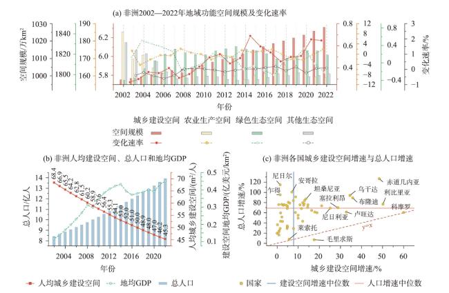
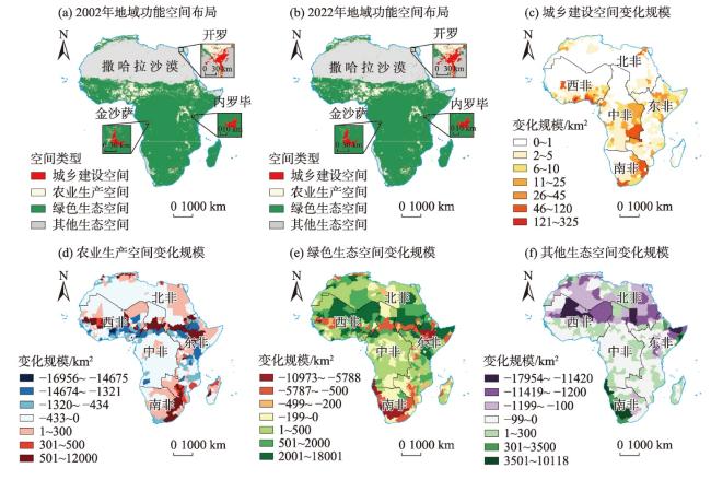
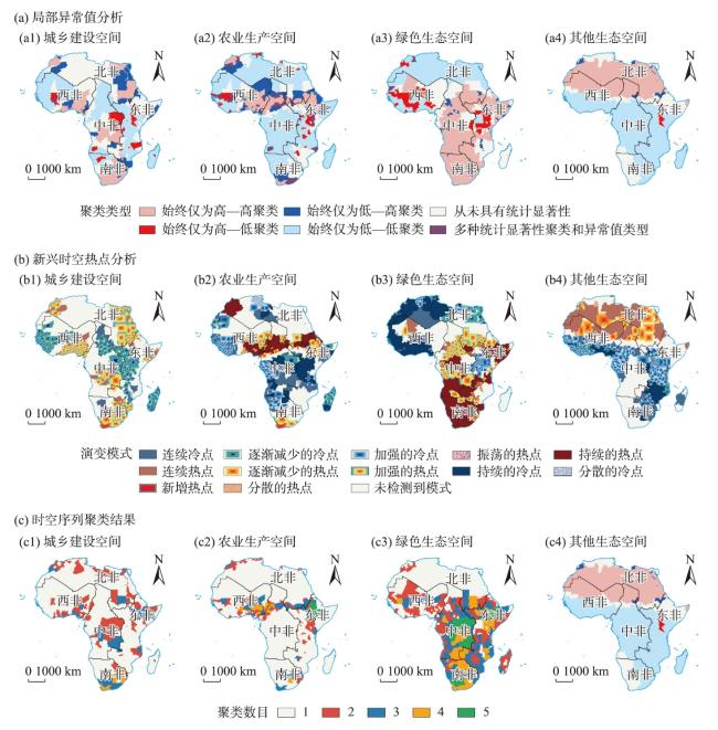
A scientific understanding of the spatial pattern change and formation mechanisms of Africa's territorial functions is crucial for fundamental research on Africa's land resources. It also aligns with China's Going Global strategy and supports the development of a China-Africa community with a shared future. Using China's territorial dominant functions of urbanization, food security, and ecological security as spatial reference benchmarks, this study classified Africa's territorial space into three major functional areas: urban-rural construction, agricultural production, and ecological protection. By applying spatiotemporal cubes, spatial transformation intensity models, and interpretable machine learning, this research analyzed the spatial evolution characteristics and regional disparities of Africa's territorial functions from 2002 to 2022. Furthermore, the study examined the mechanisms behind these changes by exploring the importance and interaction strengths of key driving factors. The results indicate that: 1) Over the study period, approximately 3.97% of Africa's territorial functional spaces had undergone structural transformation. Urban-rural construction space had expanded significantly by 9.71%, while the per capita scale of construction land had decreased by 33.78%, highlighting an increasing imbalance between population and available land. Agricultural production space had shown a fluctuating decline, with a distinct zone of drastic change forming along the southern edge of the Sahara Desert, while the internal structure of ecological protection space had significantly changed, albeit in an optimizing trend overall. 2) A clear high-dynamic transformation zone had emerged between 5°N and 15°N, where the dynamic mutual transformation between agricultural production and ecological protection spaces was most pronounced. Despite ongoing desert greening efforts, significant land degradation persisted, leading to the expansion-related structural transformations of urban-rural construction space being less prominent on a continental scale. 3) Socioeconomic development and population growth had limited effects on the structural changes of Africa's territorial functional spaces at a continental scale. Instead, variations in hydrological conditions such as atmospheric vapor pressure, temperature, and precipitation, as well as geographical factors like latitude and topographic relief, played a decisive role. Africa's territorial functional space patterns are determined by spatial transformation processes with varying scales, intensities, and driving mechanisms. Future Chinese investments and spatial development strategies in Africa must not only take into account Africa's own unique spatial evolution processes and the underlying patterns that drive these transformations, but also incorporate a thorough understanding of the continent's diverse geographical and socioeconomic contexts. It is crucial to fully leverage the spatial differentiation characteristics, including regional disparities in land use, ecological zones, and development potentials, as well as the emerging trends of its territorial functional spaces. By doing so, these strategies can maximize the comprehensive spatial benefits, fostering sustainable development outcomes that align with both African realities and Chinese strategic objectives in the region, ultimately fostering a mutually beneficial partnership.
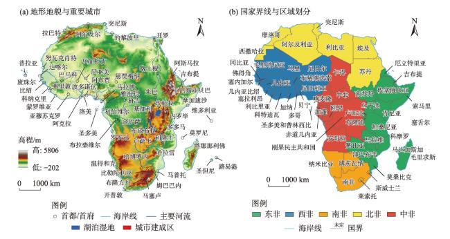
表1 非洲地域功能空间分类与国际地圈—生物圈计划(IGBP)中土地利用类型的衔接Tab.1 Matching of Africa's territorial functional space classification and land use types of the International Geosphere-Biosphere Program (IGBP) |
| 非洲地域功能空间 | IGBP土地利用类型及内涵 | 地域主导功能 | |
|---|---|---|---|
| 一级空间 | 二级空间 | ||
| 城乡建设空间 | 城市及建筑用地,包括不透水表面面积至少占30%,以建筑材料、以柏油/沥青为材料的构筑物及车辆与交通设施用地 | 承载城乡发展功能 | |
| 农业生产空间 | 耕地和半混合耕地,包括耕地面积至少占60%的区域,或40%~60%的小规模种植地与天然树木、灌木和草本植被混杂在一起的区域 | 粮食生产与粮食安全 | |
| 生态保护空间 | 绿色生态空间 | 包括覆盖率大于60%且冠高大于2 m的常绿针叶林、常绿阔叶林、落叶针叶林、落叶阔叶林和混交林以及冠高1~2 m的封闭灌木林、开阔灌木林;树木覆盖率30%~60%且冠高大于2 m的热带稀树草原、覆盖率10%~30%的热带草原及草地;至少有60%区域被永久性覆盖的水体、水覆盖率为30%~60%的湿地;每年至少超10个月且60%区域被冰雪覆盖的永久性冰川积雪区 | 提供水源涵养、生物多样性、水土保持等正向生态服务功能 |
| 其他生态空间 | 至少有60%区域是植被覆盖率小于10%的无植被裸地,包括沙地、盐碱地、岩石和裸土地等用地 | 需要生态恢复与修复 | |
注:资料来源于MODIS Collection6.1(C61)土地覆被数据产品用户指南,经翻译与整理。 |
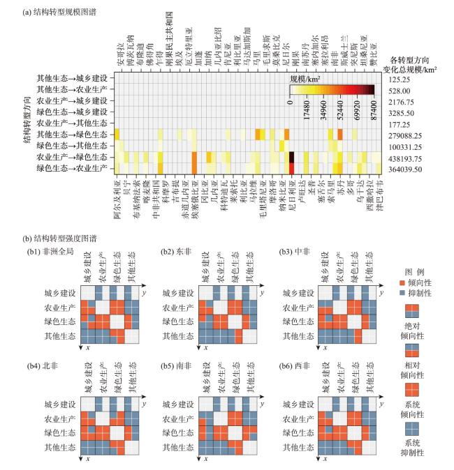
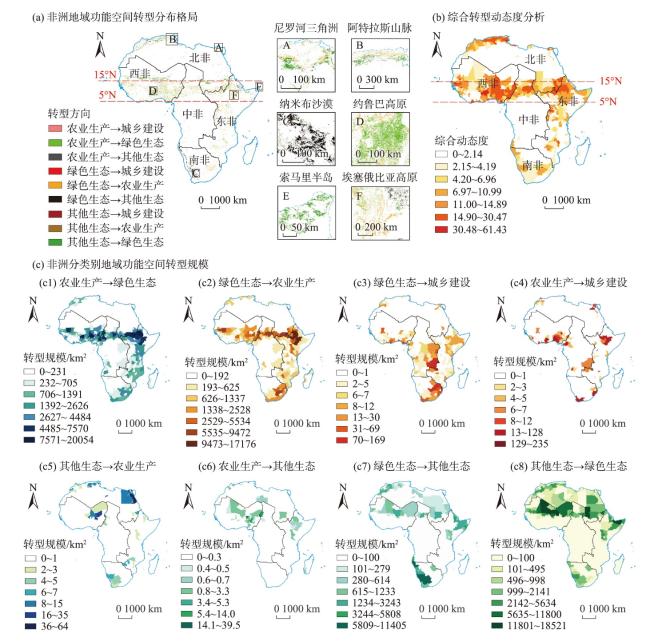
图2 非洲2002—2022年地域功能空间规模变化及城乡建设空间—人口关系分析Fig.2 Scale change of territorial functional space and the spatial-demographic relationship of urban and rural construction in Africa during 2002-2022 |
表2 非洲地域功能空间演变驱动因素的变量说明及其统计特征Tab.2 Variable description and statistical characteristics of the driving factors of Africa's territorial space change |
| 可解释机器学习变量 | 变量统计特征 | |||||||
|---|---|---|---|---|---|---|---|---|
| 类型 | 名称 | 符号 | 驱动因素含义 | 单位 | 均值 | 标准差 | ||
| 自然地理 | 海拔 | elev | 平均海拔高度 | m | 611.57 | 504.57 | ||
| 坡度 | slope | 平均坡度,由高程数据二次计算得出 | (°) | 2.22 | 2.63 | |||
| 地形起伏度 | relief | 单元内海拔最大值与最小值的差值 | m | 908.27 | 835.70 | |||
| 纬度 | lat | 以赤道为界的大地纬度,值域在0~90°之间 | (°) | 13.33 | 10.40 | |||
| 温度 | temp | 首末两年平均气温的差值 | ℃ | 0.07 | 0.39 | |||
| 降水量 | pre | 首末两年平均降水量的差值 | mm | 4.41 | 14.77 | |||
| 大气水汽压 | vap | 首末两年大气中水汽压含量的差值 | hPa | 0.04 | 0.44 | |||
| 潜在蒸散量 | pet | 首末两年区域下垫面可能达到的最大蒸散量差值 | mm | -0.01 | 0.06 | |||
| 交通区位 | 距首都距离 | capdst | 距离该国/区域首都或首府的欧氏距离 | km | 255.12 | 205.62 | ||
| 距市中心距离 | ctrdst | 距离地市中心的欧氏距离 | km | 80.87 | 159.97 | |||
| 距河流距离 | rvrdst | 距离三级以上大河的欧氏距离 | km | 214.66 | 365.46 | |||
| 距湖泊距离 | lakedst | 距离面积超过1 km²湖泊的欧氏距离 | km | 612.09 | 672.45 | |||
| 距主要港口距离 | portdst | 距沿海以贸易和货运为主港口的欧氏距离 | km | 521.71 | 414.31 | |||
| 距铁路距离 | raildst | 距主要铁路线的欧氏距离 | km | 183.22 | 292.10 | |||
| 距公路距离 | roaddst | 距主要公路的欧氏距离 | km | 57.95 | 197.01 | |||
| 社会经济 | 人口规模 | pop | 首末两年地区人口总数的差值 | 1000人 | 60.90 | 546.30 | ||
| 国内生产总值 | gdp | 首末两年地区国内生产总值的差值 | 亿元 | 0.49 | 2.75 | |||
| 人类足迹指数 | hfi | 首末两年人类足迹计算量的差值 | — | 1.00 | 1.14 | |||
| 夜间灯光指数 | nlgt | 首末两年区域灯光总强度的差值 | — | 0.19 | 1.67 | |||
| 城镇化率 | urb | 首末两年区域城镇人口占总人口比值的差值 | % | 8.21 | 63.97 | |||
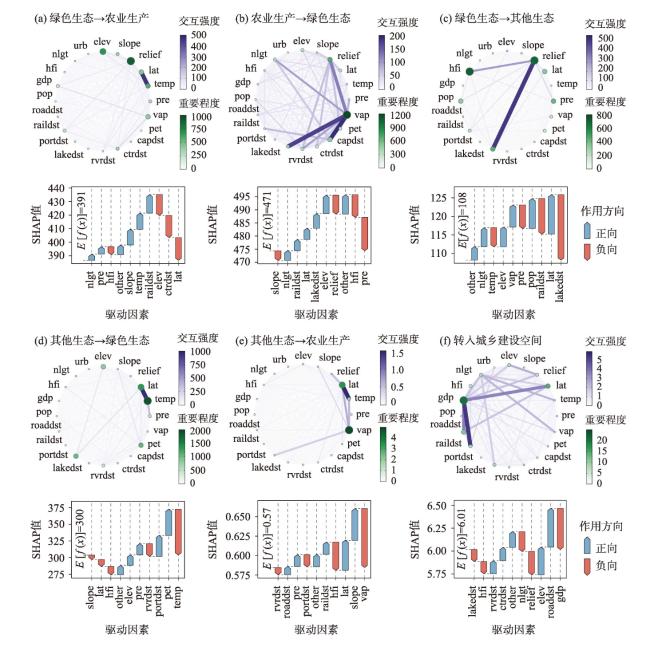
图7 非洲地域功能空间演变中驱动因素的重要程度、交互强度与SHAP探测结果注:环形图中点的大小及颜色深浅表示因子的重要程度,形状越大、颜色越深,表示该因子越重要;线的粗细及颜色表示首末两端所连因子交互作用的强度,线颜色越深、宽度越粗,表示交互作用越强;瀑布图中箭头的颜色及长度表示该因子对整体SHAP值的贡献方向及大小,起负向影响的箭头向下,反之则朝上;E[f(x)]值为该SHAP模型的基准值。 Fig.7 Importance, interaction intensity, and SHAP detection results of the driving factors in the evolution of Africa's territorial functional space |
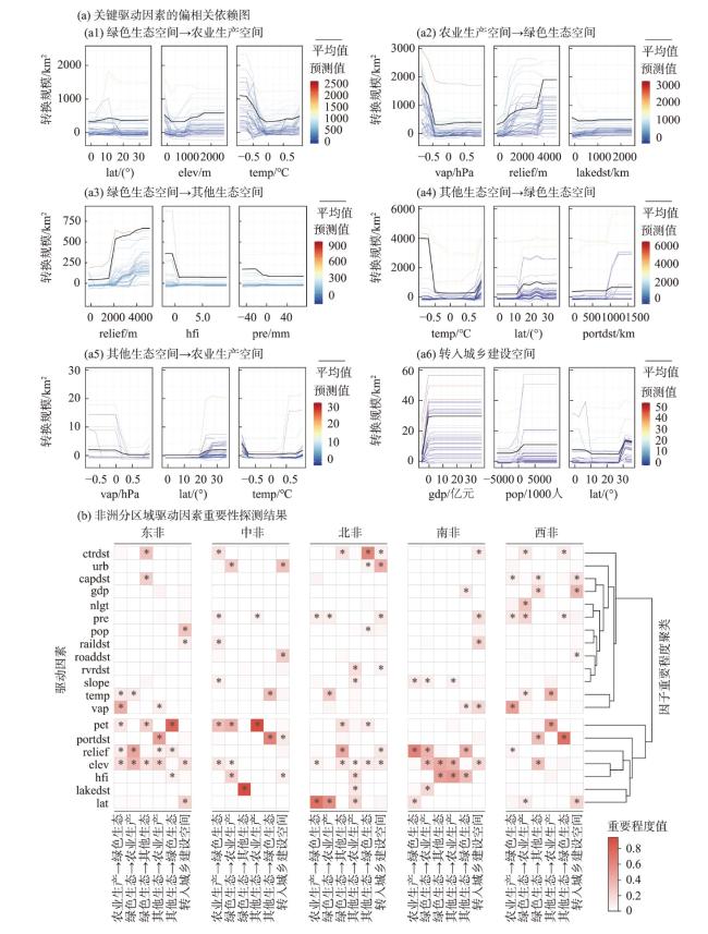
图8 典型驱动因素的偏相关依赖图及非洲各区域驱动因素重要性探测结果对比注:图a偏相关依赖图中彩色细线条表示非洲不同空间单元中地域功能空间转型规模与该驱动因素的预测关系,颜色越红表示预测值越高、越蓝则越低,黑色粗线条为非洲整体的平均值;图b中方格内“*”表示该驱动因素重要程度计算值大于非洲整体平均值。 Fig.8 Partial correlation diagram of typical driving factors and comparison of the detection results of the importance of driving factors in various regions of Africa |
| [1] |
中华人民共和国国家发展和改革委员会区域开放司推进“一带一路”建设工作领导小组办公室. 中国—非洲国家共建“一带一路”发展报告[M]. 北京: 中国计划出版社, 2023: 3-5.
[Office of the Leading Group of the Regional Opening Department of the National Development and Reform Commission of the People's Republic of China to Promote the Construction of the "Belt and Road". China-Africa development report on the joint construction of the "Belt and Road". Beijing, China: China Planning Press, 2023: 3-5.]
|
| [2] |
中华人民共和国国家国际发展合作署. 中非合作2035年愿景[EB/OL]. 2021-12-09 [2024-05-20]. http://www.cidca.gov.cn/2021-12/09/c_1211480567.htm.
[China International Development Cooperation Agency. China-Africa Cooperation Vision 2035. 2021-12-09 [2024-05-20]. http://www.cidca.gov.cn/2021-12/09/c_1211480567.htm.
|
| [3] |
联合国人类住区规划署. 联合国住房和城市可持续发展大会(人居三)非洲区域报告:非洲变革性住房和城市可持续发展[EB/OL]. 2017-01-05 [2024-05-20]. https://habitat3.org/wp-content/uploads/regional-report-africa-chinese.pdf
[United Nations Human Settlements Programme. United Nations Conference on housing and sustainable urban development (Habitat III) Africa regional report: Transformative housing and sustainable urban development in Africa. 2017-01-05 [2024-05-20]. https://habitat3.org/wp-content/uploads/regional-report-africa-chinese.pdf.
|
| [4] |
|
| [5] |
樊杰. 地域功能—结构的空间组织途径: 对国土空间规划实施主体功能区战略的讨论[J]. 地理研究, 2019, 38(10): 2373-2387.
[
|
| [6] |
邹利林, 章丽君, 刘彦随. 生态文明背景下国土空间功能研究: 过去、现在与未来[J]. 地理科学进展, 2022, 41(7): 1312-1324.
[
|
| [7] |
王亚飞, 陈佩佩, 陈东. 基于主体功能区划的中国地域功能空间结构演变解析: 人口与经济集疏视角[J]. 经济地理, 2022, 42(7): 11-21.
[
|
| [8] |
卓蓉蓉, 余斌, 曾菊新, 等. 中国重点农区乡村地域功能演变及其影响机理: 以江汉平原为例[J]. 地理科学进展, 2020, 39(1): 56-68.
[
|
| [9] |
樊杰. 我国主体功能区划的科学基础[J]. 地理学报, 2007, 62(4): 339-350.
[
|
| [10] |
黄安, 许月卿, 卢龙辉, 等. “生产—生活—生态”空间识别与优化研究进展[J]. 地理科学进展, 2020, 39(3): 503-518.
[
|
| [11] |
樊杰, 周侃. 以“三区三线”深化落实主体功能区战略的理论思考与路径探索[J]. 中国土地科学, 2021, 35(9): 1-9.
[
|
| [12] |
张雷, 刘毅, 杨波. 国家人地关系的国际比较研究[J]. 自然资源学报, 2017, 32(3): 353-362.
[
|
| [13] |
|
| [14] |
吴皓天, 刘柄麟, 张振克, 等. 2000—2020年南非海岸带土地开发利用强度时空变化研究[J]. 世界地理研究, 2023, 32(12): 18-28.
[
|
| [15] |
刘洁敏, 吕斌. 非洲欠发达地区首都新城开发策略研究: 以刚果共和国首都布拉柴维尔市为例[J]. 世界地理研究, 2021, 30(2): 276-285.
[
|
| [16] |
邱心叶, 陈爽, 刘圳南. 东非国家小城镇形成与发展的潜力: 基于最大熵模型分析[J]. 地理科学进展, 2023, 42(1): 131-144.
[
|
| [17] |
王静怡, 张悦, 陈志钢, 等. 中国杂交水稻向撒哈拉以南非洲转移的影响模拟: 基于全球局部均衡模型[J]. 经济地理, 2019, 39(4): 155-163, 231.
[
|
| [18] |
李董林, 李春顶, 蔡礼辉. 俄乌冲突局势下中东和非洲的粮食安全问题: 特征、影响和治理路径[J]. 中国农业大学学报, 2022, 27(12): 15-27.
[
|
| [19] |
|
| [20] |
|
| [21] |
|
| [22] |
|
| [23] |
|
| [24] |
|
| [25] |
|
| [26] |
|
| [27] |
张振克. 非洲地理研究回顾与展望[J]. 地域研究与开发, 2018, 37(2):175-176, 180.
[
|
| [28] |
安宁, 梁邦兴, 朱竑. “走出去”的地理学: 从人文地理学视角看中非合作研究[J]. 地理科学进展, 2018, 37(11): 1521-1532.
[
|
| [29] |
|
| [30] |
马毅, 谢嘉宬, 施斯, 等. 基于地域功能理论的市县国土空间功能分区研究[J]. 规划师, 2020, 36(18): 57-64.
[
|
| [31] |
黄晶, 薛东前, 董朝阳, 等. 干旱绿洲农业区土地利用转型生态环境效应及分异机制: 基于三生空间主导功能判别视角[J]. 地理科学进展, 2022, 41(11): 2044-2060.
[
|
| [32] |
魏伟, 尹力, 谢波, 等. 国土空间规划背景下黄河流域“三区空间”演化特征及机制[J]. 经济地理, 2022, 42(3): 44-55, 86.
[
|
| [33] |
|
| [34] |
|
| [35] |
周贵鹏, 龙花楼. 农村居民点土地利用隐性形态三维测度及其耦合协调演化研究: 以河南省为例[J]. 地理科学进展, 2023, 42(6): 1082-1097.
[
|
| [36] |
尹力, 魏伟, 薄立明, 等. 基于主体功能区战略的新疆地区“三区空间”演化解析[J]. 经济地理, 2023, 43(7): 52-64.
[
|
| [37] |
刘瑞, 朱道林. 基于转移矩阵的土地利用变化信息挖掘方法探讨[J]. 资源科学, 2010, 32(8): 1544-1550.
[
|
| [38] |
李帅呈, 龚健, 杨建新, 等. 兰西城市群土地利用/覆被变化模式特征: 基于强度分析框架[J]. 资源科学, 2023, 45(3): 480-493.
[
|
| [39] |
|
| [40] |
|
| [41] |
|
| [42] |
|
| [43] |
张莉, 吴文斌, 宋茜, 等. 2000—2010年非洲耕地利用格局变化及其生态环境背景分析[J]. 中国农业科学, 2018, 51(6): 1144-1155.
[
|
| [44] |
|
| [45] |
|
| [46] |
|
| [47] |
|
| [48] |
|
| [49] |
王妤, 孙斌栋, 张婷麟. 国家城市规模分布的时空演化特征及影响因素: 基于LandScan的全球实证研究[J]. 地理科学进展, 2021, 40(11): 1812-1823.
[
|
| [50] |
任航, 张振克,
[
|
| [51] |
蒋大亮, 任航, 刘柄麟, 等. 1996—2015年非洲人口扩张区域类型划分与区域演变分析[J]. 世界地理研究, 2021, 30(4): 851-863.
[
|
| [52] |
邵静, 王茂军. 中国与OECD在非援助国别分配的空间关系研究[J]. 地理科学进展, 2020, 39(5): 766-778.
[
|
| [53] |
|
| [54] |
陈沛然, 王成金, 刘卫东. 中国海外港口投资格局的空间演化及其机理[J]. 地理科学进展, 2019, 38(7): 973-987.
[
|
| [55] |
|
/
| 〈 |
|
〉 |