
资源型城市空间冲突测度及其空间响应研究
|
郑洋(1994— ),女,内蒙古乌兰察布人,博士生,研究方向为矿区土地利用和国土空间规划。E-mail: zhengyang01125@163.com. |
收稿日期: 2022-06-29
修回日期: 2022-08-30
网络出版日期: 2023-02-24
基金资助
国家重点研发计划项目(2018YFD1100803)
Spatial conflict measurement in resource-based cities and spatial responses
Received date: 2022-06-29
Revised date: 2022-08-30
Online published: 2023-02-24
Supported by
National Key Research and Development Program of China(2018YFD1100803)
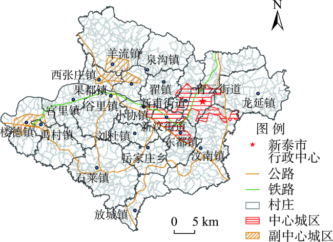
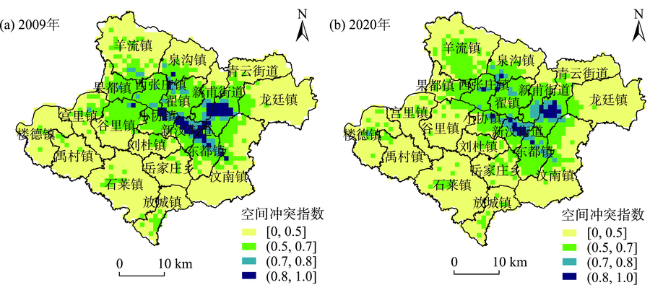
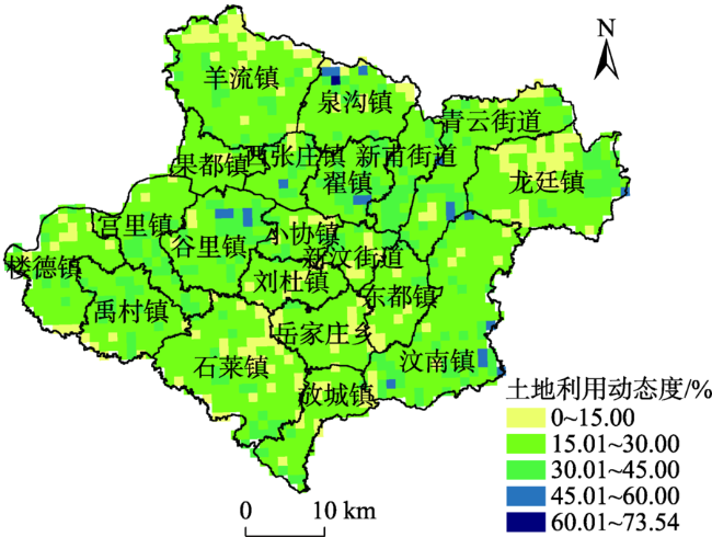
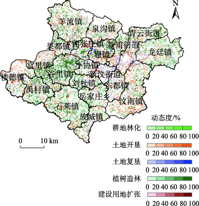
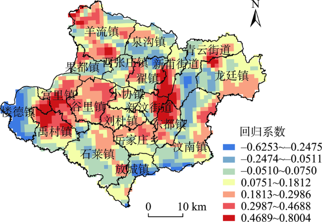
科学诊断资源型城市空间冲突等级,厘清空间冲突变化与土地利用间的复杂关系,对城市转型发展、区域资源合理利用具有重要意义。论文基于山东省新泰市资源型城市特征,以生态系统服务价值和土地利用为视角,从空间压力、空间暴露性和空间风险响应维度构建空间冲突测度模型,并运用地理加权回归模型探讨了空间冲突的变化与土地利用调整间的关系。结果表明:① 2009—2020年,新泰市空间冲突指数保持稳定,变化量仅为0.0018,且不同冲突等级的变化趋势不同;空间冲突格局呈圈层分布,由中心向四周等级逐渐减弱。② 2009—2020年,新泰市平均土地利用动态度为23.14%,空间布局差异性显著,土地利用特征以耕地林化、土地整治、建设用地及生态用地扩张为主。③ 地理加权回归模型分析显示,土地利用动态度与空间冲突指数变化呈显著相关(P<0.01,R2=0.8517),平均系数值为0.1381,且以正相关为主,表明新泰市土地利用调整对空间冲突的抑制产生了积极影响。研究可为区域土地合理利用、空间冲突治理及空间结构优化提供科学依据。
郑洋 , 程琳琳 , 王义方 , 王俊奇 . 资源型城市空间冲突测度及其空间响应研究[J]. 地理科学进展, 2023 , 42(2) : 275 -286 . DOI: 10.18306/dlkxjz.2023.02.006
Scientifically diagnose the spatial conflict of resource-based cities and clarify the complex relationship between spatial conflict and land use are important for urban development transformation and rational use of regional resources. Based on the characteristics of resource-based cities, this study constructed a spatial conflict measurement model considering spatial pressure, spatial exposure, and spatial risk response dimensions with the perspective of land use and ecosystem service value, and explored the relationship between spatial conflict and land use using a geographically weighted regression model. The results indicate that: 1) From 2009 to 2020, the spatial conflict index of Xintai City remained stable with a change of 0.0018 only. The change trends of different conflict levels varied. The spatial pattern was zonal, and the conflict level gradually decreased from the center to the peripheral areas. 2) From 2009 to 2020, the average land use dynamic degree of Xintai City was 23.14%, the spatial layout was significantly different, and the land use changes were mainly cultivated land conversion to woodland, land reclamation, expansion of construction land, and afforestation. 3) Based on the analysis of the geographically weighted regression model, the dynamic degree of land use was significantly correlated with the change of spatial conflict index (P < 0.01, R2 =0.8517), and the average coefficient value was 0.1381, dominated by positive correlation. The research provides a scientific basis for the rational use of regional land, governance of spatial conflicts, and optimization of spatial structure in the city.
Key words: spatial conflict; land use; dynamic change; resource-based city; Xintai City
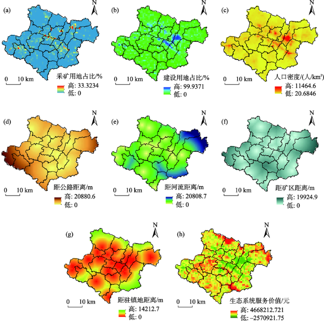
表1 新泰市生态系统服务价值系数Tab.1 Ecosystem service value coefficients in Xintai City (元/(hm2·a)) |
| 功能类型 | 耕地 | 园地 | 林地 | 草地 | 建设用地 | 水域 | 未利用地 | ||
|---|---|---|---|---|---|---|---|---|---|
| 调节服务 | 气体调节 | 1070.33 | 4602.40 | 7492.28 | 1712.52 | -5180.38 | -1626.89 | 0 | |
| 气候调节 | 1905.18 | 3853.17 | 5779.76 | 1926.59 | 0 | 9397.46 | 0 | ||
| 水源涵养 | 1284.39 | 4281.30 | 6850.08 | 1712.52 | -16076.29 | 11163.49 | 64.22 | ||
| 废物处理 | 3510.67 | 2804.25 | 2804.25 | 2804.25 | -5266.00 | 16825.52 | 21.41 | ||
| 支持服务 | 土壤形成与保护 | 3125.35 | 6261.40 | 8348.54 | 4174.27 | 42.81 | 920.48 | 42.81 | |
| 生物多样性保护 | 1519.86 | 4655.92 | 6978.52 | 2333.31 | 727.82 | 2670.46 | 727.82 | ||
| 供给服务 | 食物生产 | 2140.65 | 428.13 | 214.07 | 642.20 | 21.41 | 214.07 | 21.41 | |
| 原材料 | 214.07 | 2836.36 | 5565.69 | 107.03 | 0 | 42.81 | 2140.65 | ||
| 文化服务 | 娱乐文化 | 21.41 | 1412.83 | 2740.03 | 85.63 | 21.41 | 5292.76 | 21.41 | |
| 合计 | 14791.90 | 31135.77 | 46773.22 | 15498.31 | -25709.22 | 44900.15 | 3039.72 | ||
表2 2009—2020年新泰市空间冲突指数测算结果Tab.2 Spatial conflict index of Xintai City during 2009-2020 |
| 冲突级别 | 阈值 | 2009年 | 2020年 | 变化量 | |||||||
|---|---|---|---|---|---|---|---|---|---|---|---|
| 网格单元/个 | 占比/% | 网格单元/个 | 占比/% | 网格单元/个 | 占比/% | ||||||
| 稳定可控 | [0, 0.5] | 1187 | 67.10 | 1207 | 68.23 | 20 | 1.13 | ||||
| 基本可控 | (0.5, 0.7] | 477 | 26.96 | 393 | 22.22 | -84 | -4.74 | ||||
| 基本失控 | (0.7, 0.8] | 56 | 3.17 | 146 | 8.25 | 90 | 5.08 | ||||
| 严重失控 | (0.8, 1.0] | 49 | 2.77 | 23 | 1.30 | -26 | -1.47 | ||||
| 指数均值 | 0.4544 | 0.4526 | -0.0018 | ||||||||
表3 GWR模型的回归系数特征Tab.3 Characteristics of regression coefficients of the GWR model |
| 变量 | 最小值 | 下四分位 | 中位数 | 上四分位 | 最大值 | 均值 |
|---|---|---|---|---|---|---|
| 土地利用动态度 | -0.6253 | -0.2688 | 0.0876 | 0.4439 | 0.8004 | 0.1381 |
| AICc | -5302.4827 | |||||
| R2 | 0.8517 | |||||
| 调整R2 | 0.7929 | |||||
| [1] |
余建辉, 李佳洺, 张文忠. 中国资源型城市识别与综合类型划分[J]. 地理学报, 2018, 73(4): 677-687.
[
|
| [2] |
卢硕, 张文忠, 余建辉, 等. 资源型城市演化阶段识别及其发展特征[J]. 地理学报, 2020, 75(10): 2180-2191.
[
|
| [3] |
周国华, 彭佳捷. 空间冲突的演变特征及影响效应: 以长株潭城市群为例[J]. 地理科学进展, 2012, 31(6): 717-723.
[
|
| [4] |
吴蒙, 周冯琦, 程进. 基于生态系统服务的快速城市化地区空间冲突测度及时空演变特征[J]. 中国人口·资源与环境, 2021, 31(5): 12-20.
[
|
| [5] |
|
| [6] |
|
| [7] |
|
| [8] |
|
| [9] |
贺艳华, 唐承丽, 周国华, 等. 基于地理学视角的快速城市化地区空间冲突测度: 以长株潭城市群地区为例[J]. 自然资源学报, 2014, 29(10): 1660-1674.
[
|
| [10] |
田若颖, 陈勇, 周皓, 等. 生态安全格局视角下矿业城市土地利用空间冲突识别[J]. 矿业研究与开发, 2020, 40(6): 153-159.
[
|
| [11] |
陈士梅, 艾东, 付野. 基于生态安全的空间冲突测度与影响因素研究: 以昆明市为例[J]. 中国农业大学学报, 2020, 25(5): 141-150.
[
|
| [12] |
李云, 张艳芳, 田茂, 等. 基于“重要性—敏感性—冲突性”的陕北生态保护重点区域辨识[J]. 长江流域资源与环境, 2020, 29(3): 643-653.
[
|
| [13] |
陈德超, 施祝凯, 王祖静, 等. 苏州环太湖地区生态网络构建与空间冲突识别[J]. 生态与农村环境学报, 2020, 36(6): 778-787.
[
|
| [14] |
吴蒙, 王琳琳, 程进. 长三角城市群国土空间碳汇冲突测度及空间格局特征分析[J]. 资源科学, 2022, 44(10):2048-2059.
[
|
| [15] |
周德, 徐建春, 王莉. 环杭州湾城市群土地利用的空间冲突与复杂性[J]. 地理研究, 2015, 34(9): 1630-1642.
[
|
| [16] |
唐凯, 周国华. 基于经济学视角的空间冲突形成原因及其风险测度: 以长株潭城市群为例[J]. 湖南师范大学自然科学学报, 2013, 36(3): 90-94.
[
|
| [17] |
|
| [18] |
|
| [19] |
黄安, 许月卿, 卢龙辉, 等. “生产—生活—生态”空间识别与优化研究进展[J]. 地理科学进展, 2020, 39(3): 503-518.
[
|
| [20] |
刘耀林, 张扬, 张琰, 等. 特大城市“三线冲突”空间格局及影响因素[J]. 地理科学进展, 2018, 37(12): 1672-1681.
[
|
| [21] |
赵旭, 汤峰, 张蓬涛, 等. 基于CLUE-S模型的县域生产—生活—生态空间冲突动态模拟及特征分析[J]. 生态学报, 2019, 39(16): 5897-5908.
[
|
| [22] |
邱国强, 牛潜, 吴振华, 等. 苏锡常城市群土地利用冲突空间测度及异质性分析[J]. 水土保持研究, 2022, 29(4): 400-406, 414.
[
|
| [23] |
|
| [24] |
|
| [25] |
|
| [26] |
|
| [27] |
|
| [28] |
唐常春, 卢幸芷, 雷钧钧, 等. 大城市边缘区城乡多维空间冲突特征与形成机制: 以韶关市转溪村为例[J]. 经济地理, 2022, 42(1): 79-89.
[
|
| [29] |
邹利林, 刘彦随, 王永生. 中国土地利用冲突研究进展[J]. 地理科学进展, 2020, 39(2): 298-309.
[
|
| [30] |
文琦, 侯凯元, 郑殿元, 等. 成长型资源城市产业转型能力评价与优化路径: 以榆林市为例[J]. 地理科学, 2022, 42(4): 682-691.
[
|
| [31] |
徐新良. 中国人口空间分布公里网格数据集[DB/OL]. 中国科学院资源环境科学数据中心数据注册与出版系统(http://www.resdc.cn/DOI), 2017. doi: 10.12078/2017121101
[
|
| [32] |
谢高地, 张彩霞, 张雷明, 等. 基于单位面积价值当量因子的生态系统服务价值化方法改进[J]. 自然资源学报, 2015, 30(8): 1243-1254.
[
|
| [33] |
吴克宁, 赵珂, 赵举水, 等. 基于生态系统服务功能价值理论的土地利用规划环境影响评价: 以安阳市为例[J]. 中国土地科学, 2008, 22(2): 23-28.
[
|
| [34] |
万伦来, 杨峻, 周紫凡, 等. 煤炭资源型城市生态系统服务功能的时空变化特征分析: 来自2006—2015年安徽省淮南市的经验证据[J]. 环境科学学报, 2018, 38(8): 3322-3328.
[
|
| [35] |
霍冉, 徐向阳, 高俊莲, 等. 煤炭资源型城市生态系统服务空间特征及其与居民福祉关系[J]. 土壤通报, 2020, 51(1): 31-39.
[
|
| [36] |
王思远, 刘纪远, 张增祥, 等. 中国土地利用时空特征分析[J]. 地理学报, 2001, 56(6): 631-639.
[
|
| [37] |
周浩, 雷国平, 杨雪昕. 三江平原典型流域土地利用格局变化与空间分异研究[J]. 农业机械学报, 2017, 48(5): 142-151.
[
|
| [38] |
|
| [39] |
彭佳捷, 周国华, 唐承丽, 等. 基于生态安全的快速城市化地区空间冲突测度: 以长株潭城市群为例[J]. 自然资源学报, 2012, 27(9): 1507-1519.
[
|
| [40] |
陈艳红. 基于土地利用变化的长江经济带景观生态风险评价与影响因素研究[D]. 武汉: 湖北大学, 2021.
[
|
/
| 〈 |
|
〉 |
