
青藏高原东部黄河切开若尔盖湖盆的沉积证据与年代研究
|
王娜(1992— ),女,内蒙古赤峰人,博士生,主要从事资源开发与环境演变研究。E-mail: wn072701@163.com |
收稿日期: 2022-01-20
修回日期: 2022-03-16
网络出版日期: 2022-10-25
基金资助
国家自然科学基金项目(41971116)
国家自然科学基金项目(41801060)
陕西师范大学博士自由探索项目(2020TS102)
Sedimentary evidence and age of the Zoige Basin dissected by the Yellow River in eastern Tibetan Plateau
Received date: 2022-01-20
Revised date: 2022-03-16
Online published: 2022-10-25
Supported by
National Natural Science Foundation of China(41971116)
National Natural Science Foundation of China(41801060)
The Fundamental Research Funds for the Central Universities(2020TS102)
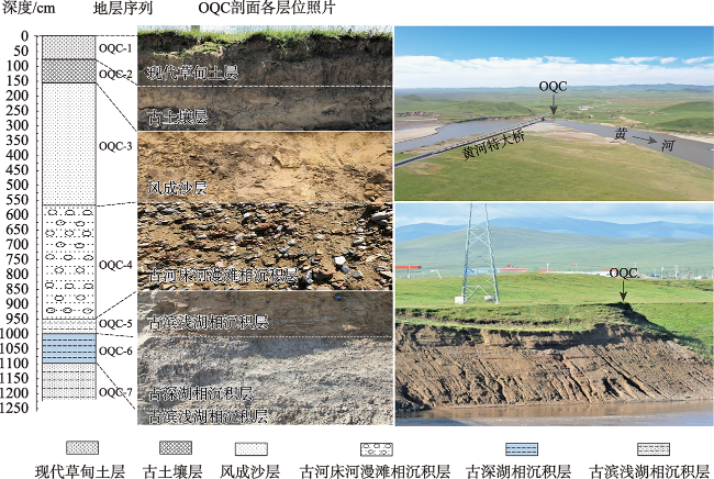
对青藏高原东部若尔盖盆地内外实地考察,在玛曲瓶颈段黄河二级阶地前沿陡坎,发现了含有古深湖相和古河床河漫滩相地层序列的典型沉积剖面。通过沉积物粒度特征分析和光释光(optically stimulated luminescence,OSL)测年,研究结果表明:① 剖面下部淡蓝灰色古深湖相沉积层为深水厌氧环境下形成的湖相沉积物,而覆盖其上的杂色卵石层夹淡黄橙色透镜状沙层则是古河床河漫滩相沉积物,指示了强动力流水作用过程。这2组地层的不整合接触关系,是黄河切开若尔盖湖盆导致古湖水外泄的直接证据。② 剖面古深湖相沉积层顶部和古滨浅湖相沉积层底部的OSL测年结果表明,古黄河在37 ka BP切开若尔盖湖盆,导致湖水外泄,35 ka BP湖水变浅消失,黄河沟通了若尔盖盆地水系。③ 晚更新世东昆仑大断裂强烈的新构造运动和37 ka 温暖湿润气候的综合影响使得尚处于玛曲断陷谷地草原的古黄河源溯源侵蚀加剧,由西向东在玛曲城南瓶颈段切开了若尔盖古湖盆,导致古湖水外泄,从而沟通了若尔盖湖盆的水系,使之成为黄河源。该研究结果对于深入理解青藏高原东北部河湖水系演变及黄河水系的形成具有重要的科学意义。
王娜 , 查小春 , 黄春长 , 张玉柱 , 周亚利 , 庞奖励 , 戎晓庆 , 尚瑞清 , 柴佳楠 . 青藏高原东部黄河切开若尔盖湖盆的沉积证据与年代研究[J]. 地理科学进展, 2022 , 41(8) : 1453 -1466 . DOI: 10.18306/dlkxjz.2022.08.009
Through extensive and detailed field investigation inside and outside the Zoige Basin in eastern Tibet Plateau, a typical sedimentary profile containing the stratigraphic sequence of paleolake facies and paleo-riverbed floodplain facies was found in the front of the second terrace of the Yellow River in the Maqu section at the outlet of the Zoige Basin. Through grain size characteristic analysis and Optically Stimulated Luminescence(OSL) dating, we found that: 1) The pale-blue-grey paleolake sedimentary layer in the profile indicates that the lacustrine sediment formed in the deep-water anoxic environment, while the mottled pebble layer covered by the pale-yellow-orange lenticular sand layer was a typical fluvial floodplain sediment, which indicates the process of strong dynamic flow. The unconformable contact relationship between the two layers indicates that the profile is a typical sedimentary evidence for studying the Zoige Basin dissected by the Yellow River. 2) The OSL dating results of the top boundary of the pale-blue-gray paleolake sedimentary layer and the bottom boundary of the paleoshore-shallow lake sedimentary layer show that the Yellow River dissected the Zoige Basin at 37 ka BP, resulting in the leakage of lake water. At 35 ka BP, the lake water became shallow and disappeared, and then the Yellow River connected the water system of the Zoige Basin. 3) The strong neotectonic movement of the East Kunlun fault in late Pleistocene and the warm and humid climate of the Tibet Plateau in 37 ka resulted in the aggravation of the headward erosion of the paleo-Yellow River source in the rift valley grassland, and the Zoige Basin was dissected by the paleo-Yellow River from the west to the east in the Maqu bottleneck reach, resulting in the discharge of the paleolake water through the Yellow River, thus connecting the water system of the Zoige Basin and making it the source of the Yellow River. The study results have important scientific significance for an in-depth understanding of the evolution of river-lake water system and the formation of Yellow River water system in northeastern Tibet Plateau.
Key words: sedimentary evidence; OSL dating; headward erosion; Yellow River; Zoige Basin
图3 若尔盖盆地OQC剖面各地层沉积物粒度分布频率曲线Fig.3 Sediment size distribution frequency curve of the OQC profile in the Zoige Basin |
表1 若尔盖盆地OQC剖面各地层沉积物粒度特征值Tab.1 Characteristic values of grain size for each stratum of the OQC profile in the Zoige Basin |
| 地层 编号 | 地层层位 | 黏粒 (<2 μm)/% | 细粉沙 (2~16 μm)/% | 粗粉沙 (16~63 μm)/% | 沙 (>63 μm)/% | 平均粒径 Mz/μm | 标准偏差 | 峰度 | 偏度 |
|---|---|---|---|---|---|---|---|---|---|
| OQC-1 | 现代草甸土层 | 8.99 | 31.41 | 35.90 | 23.70 | 38.27 | 2.19 | 0.93 | 0.25 |
| OQC-2 | 古土壤层 | 10.80 | 26.20 | 34.30 | 28.70 | 44.05 | 2.35 | 0.93 | 0.34 |
| OQC-3 | 风成沙层 | 5.27 | 12.01 | 14.00 | 68.72 | 95.05 | 1.96 | 1.61 | 0.66 |
| OQC-4 | 古河床河漫滩相沉积层 | 2.41 | 6.37 | 3.51 | 87.71 | 272.57 | 1.38 | 3.29 | 0.46 |
| OQC-5 | 古滨浅湖相沉积层 | 12.40 | 36.65 | 38.05 | 12.90 | 25.62 | 2.16 | 0.96 | 0.25 |
| OQC-6 | 古深湖相沉积层 | 18.50 | 53.30 | 24.00 | 4.20 | 12.92 | 2.02 | 0.98 | 0.05 |
| OQC-7 | 古滨浅湖相沉积层 | 10.90 | 25.70 | 41.50 | 21.90 | 36.18 | 2.21 | 1.01 | 0.40 |
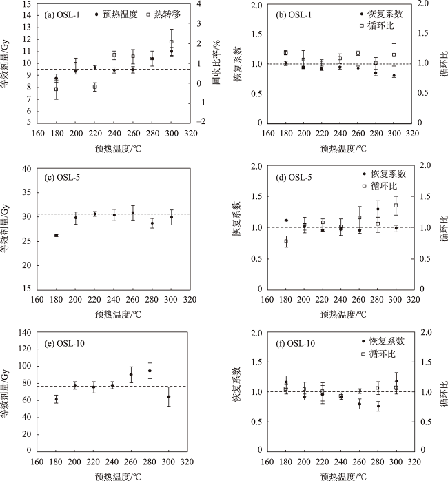
图4 若尔盖盆地OQC剖面OSL-1的预热坪区和热转移实验(a)、剂量恢复和循环比实验(b),以及OSL-5和OSL-10的预热坪区(c, e)及剂量恢复和循环比实验(d, f)Fig.4 Preheat plateau plot and thermal transfer (a) and dose recovery and recycling ratio (b) of sample OSL-1, preheat plateau plot (c, e) and dose recovery and recycling ratio (d, f) of sample OSL-5 and OSL-10 of the OQC profile in the Zoige Basin |
表2 若尔盖盆地OQC剖面OSL测年结果Tab.2 OSL dating results for the OQC profile in the Zoige Basin |
| 样品 编号 | 深度 /cm | 地层层位 | U /10-6 | Th /10-6 | K /% | 含水量 /% | 环境剂量率 /(Gy·ka-1) | 等效剂量 /Gy | OSL年龄 /ka |
|---|---|---|---|---|---|---|---|---|---|
| OSL-1 | 75~80 | 现代草甸土层底部 | 1.29±0.3 | 8.07±0.6 | 1.72±0.04 | 20±3 | 2.45±0.08 | 6.81±0.14 | 2.79±0.10 |
| OSL-2 | 155~160 | 古土壤层底部 | 1.51±0.3 | 8.74±0.6 | 1.57±0.04 | 20±3 | 2.37±0.07 | 20.35±0.68 | 8.59±0.39 |
| OSL-3 | 165~170 | 风成沙层顶部 | 1.42±0.3 | 8.94±0.6 | 1.54±0.04 | 21±3 | 2.31±0.07 | 19.68±0.43 | 8.60±0.38 |
| OSL-4 | 545~550 | 风成沙层底部 | 1.43±0.3 | 8.14±0.6 | 1.58±0.04 | 21±3 | 2.20±0.07 | 20.29±0.32 | 9.24±0.32 |
| OSL-5 | 645~650 | 古河床河漫滩相沉积层上部 | 1.01±0.3 | 5.82±0.6 | 1.47±0.04 | 22±3 | 1.86±0.06 | 24.57±0.92 | 13.20±0.67 |
| OSL-6 | 895~900 | 古河床河漫滩相沉积层下部 | 1.73±0.3 | 9.45±0.6 | 1.81±0.04 | 22±3 | 2.44±0.07 | 81.25±0.96 | 33.35±1.06 |
| OSL-7 | 955~960 | 古滨浅湖相沉积层顶部 | 3.35±0.4 | 11.23±0.7 | 1.64±0.04 | 23±3 | 2.67±0.08 | 94.00±5.41 | 35.15±2.30 |
| OSL-8 | 990~995 | 古滨浅湖相沉积层底部 | 1.86±0.4 | 10.99±0.7 | 1.75±0.04 | 25±3 | 2.42±0.08 | 85.77±4.64 | 35.42±2.40 |
| OSL-9 | 1005~1010 | 古深湖相沉积层顶部 | 2.37±0.4 | 14.99±0.7 | 2.43±0.04 | 25±3 | 3.30±0.09 | 122.64±9.39 | 37.17±3.03 |
| OSL-10 | 1045~1150 | 古深湖相沉积层底部 | 2.15±0.4 | 10.71±0.7 | 1.97±0.04 | 25±3 | 2.65±0.08 | 105.97±6.56 | 40.01±2.77 |
| OSL-11 | 1110~1115 | 古滨浅湖相沉积层顶部 | 1.41±0.3 | 9.22±0.6 | 1.67±0.04 | 25±3 | 2.17±0.07 | 100.27±7.40 | 46.29±3.70 |
| [1] |
黄春长. 若尔盖盆地河流古洪水沉积及其对黄河水系演变问题的启示[J]. 地理学报, 2021, 76(3): 612-625.
[
|
| [2] |
孙广友, 张文芬. 若尔盖高原黄河古河道及其古地理意义[J]. 地理科学, 1987, 7(3): 266-272, 296.
[
|
| [3] |
周明镇. 阿坝藏族自治州第四纪哺乳动物化石[J]. 第四纪研究, 1959, 2(1): 8-13.
[
|
| [4] |
王云飞, 王苏民, 薛滨, 等. 黄河袭夺若尔盖古湖时代的沉积学依据[J]. 科学通报, 1995, 40(8): 723-725.
[
|
| [5] |
李世杰, 施雅风, 王苏民. 若尔盖盆地3万年来气候与环境变化的地质记录[C]// 青藏项目专家委员会. 青藏高原形成演化、环境变迁与生态系统研究. 北京: 科学出版社, 1995: 227-235.
[
|
| [6] |
杨达源, 吴胜光, 王云飞. 黄河上游的阶地与水系变迁[J]. 地理科学, 1996, 16(2): 137-143.
[
|
| [7] |
魏全伟, 谭利华, 王随继. 河流阶地的形成、演变及环境效应[J]. 地理科学进展, 2006, 25(3): 55-61.
[
|
| [8] |
徐茂其. 川西北若尔盖高原第四纪环境演变概要[J]. 西南师范大学学报(自然科学版), 1988, 13(4): 94-100.
[
|
| [9] |
李志威, 王兆印, 余国安, 等. 黄河源玛曲河段河型沿程变化及其原因[J]. 泥沙研究, 2013(3): 51-58.
[
|
| [10] |
胡光印, 董治宝, 张正偲, 等. 若尔盖盆地起沙风风况与输沙势特征[J]. 中国沙漠, 2020, 40(5): 20-24.
[
|
| [11] |
褚琳, 黄翀, 刘高焕, 等. 2000-2010年黄河源玛曲高寒湿地生态格局变化[J]. 地理科学进展, 2014, 33(3): 326-335.
[
|
| [12] |
何文贵, 袁道阳, 熊振, 等. 东昆仑断裂带东段玛曲断裂新活动特征及全新世滑动速率研究[J]. 地震, 2006, 26(4): 67-75.
[
|
| [13] |
|
| [14] |
李玫, 罗鸿兵, 宋慧瑾, 等. 若尔盖湿地土壤水分特征及动态模拟[J]. 人民黄河, 2014, 36(3): 64-66.
[
|
| [15] |
戎晓庆, 庞奖励, 黄春长, 等. 青海官亭盆地史前灾难性地表过程及其影响研究[J]. 地理科学进展, 2020, 39(8): 1319-1332.
[
|
| [16] |
薛天翼, 王红亚. 湖泊(水库)沉积物分析在土壤侵蚀研究中的运用[J]. 地理科学进展, 2018, 37(7): 890-900.
[
|
| [17] |
陈京, 吉力力·阿不都外力, 马龙. 赛里木湖沉积物有机质变化特征及其环境信息[J]. 冰川冻土, 2016, 38(3): 761-768.
[
|
| [18] |
|
| [19] |
赖忠平, 欧先交. 光释光测年基本流程[J]. 地理科学进展, 2013, 32(5): 683-693.
[
|
| [20] |
|
| [21] |
|
| [22] |
|
| [23] |
|
| [24] |
川西北地质大队. 四川省若尔盖高原泥炭区泥炭资源远景地质调查报告[R]. 成都: 四川省地质矿产局科学研究所, 1987.
[Northwest Sichuan Geology Group. Investigating report of peat resource in the Zoige Plateau of Sichuan Province. Chengdu, China: Sichuan Institute of Geology and Mineral Ore, 1987. ]
|
| [25] |
宗冠福, 徐钦琦, 陈万勇. 阿坝藏族自治州若尔盖晚更新世地层及哺乳类化石[J]. 古脊椎动物学报, 1985, 23(2): 161-166, 186.
[
|
| [26] |
盛海洋, 王丽. 黄河上游若尔盖盆地黄河古河道研究[J]. 人民黄河, 2008, 30(12): 6-8.
[
|
| [27] |
赵志中, 乔彦松, 王书兵, 等. 青藏高原东缘第四纪地质与环境调查的新进展[C]// 地质力学专业委员会与第四纪地质专业委员会. 青藏高原地质过程与环境灾害效应文集. 北京: 地震出版社, 2005.
[
|
| [28] |
|
| [29] |
孙晓红, 赵艳, 李泉. 青藏高原东部若尔盖盆地全新世泥炭地发育和植被变化[J]. 中国科学(地球科学), 2017, 47(9): 1097-1109.
[
|
| [30] |
陈莹璐, 黄春长, 张玉柱, 等. 黄河源区玛曲段末次冰消期古洪水事件及其光释光测年研究[J]. 冰川冻土, 2017, 39(3): 549-562.
[
|
| [31] |
王富葆, 韩辉友, 阎革, 等. 青藏高原东北部30 ka以来的古植被与古气候演变序列[J]. 中国科学(地球科学), 1996, 26(2): 111-117.
[
|
| [32] |
潘保田, 李吉均, 周尚哲. 黄河最上游发育历史初步研究[C]// 中国地理学会地貌与第四纪专业委员会. 地貌过程与环境. 北京: 地震出版社, 1993: 17-21.
[
|
| [33] |
甄治国, 钟巍, 薛积彬, 等. 中国不同区域MIS-3时期气候特征研究进展[J]. 冰川冻土, 2008, 30(5): 814-824.
[
|
| [34] |
|
| [35] |
|
| [36] |
|
| [37] |
施雅风, 贾玉连, 于革, 等. 40-30 kaBP青藏高原及邻区高温大降水事件的特征、影响及原因探讨[J]. 湖泊科学, 2002, 14(1): 1-11.
[
|
| [38] |
黄赐璇, 张青松, 刘福涛. 西藏日土县班公错地区晚更新世晚期植物群与古气候探讨[J]. 自然资源学报, 1989, 4(3): 247-253.
[
|
| [39] |
山发寿, 杜乃秋, 孔昭宸. 青海湖盆地35万年来的植被演化及环境变迁[J]. 湖泊科学, 1993, 5(1): 9-17, 99-100.
[
|
| [40] |
李炳元. 青藏高原大湖期[J]. 地理学报, 2000, 55(2): 174-182.
[
|
| [41] |
吴敬禄, 王苏民, 潘红玺, 等. 青藏高原东部RM孔140 ka以来湖泊碳酸盐同位素记录的古气候特征[J]. 中国科学(地球科学), 1997, 27(3): 255-259.
[
|
| [42] |
沈才明, 唐领余, 王苏民, 等. 若尔盖盆地RM孔孢粉记录及其年代序列[J]. 科学通报, 2005, 50(3): 246-254.
[
|
| [43] |
马寅生, 施炜, 张岳桥, 等. 东昆仑活动断裂带玛曲段活动特征及其东延[J]. 地质通报, 2005, 24(1): 30-35.
[
|
/
| 〈 |
|
〉 |

