
地图与制图术:国际批判制图学/GIS研究进展
|
王韬(1991— ),男,重庆人,博士生,研究方向为政治地理学、批判制图学。E-mail: 417018045@qq.com |
收稿日期: 2021-06-03
修回日期: 2022-03-22
网络出版日期: 2022-08-28
Mapping and “cartographicality”: Progress review of critical cartography and critical GIS
Received date: 2021-06-03
Revised date: 2022-03-22
Online published: 2022-08-28
Supported by
National Natural Science Foundation of China(42142028)
National Natural Science Foundation of China(42071187)
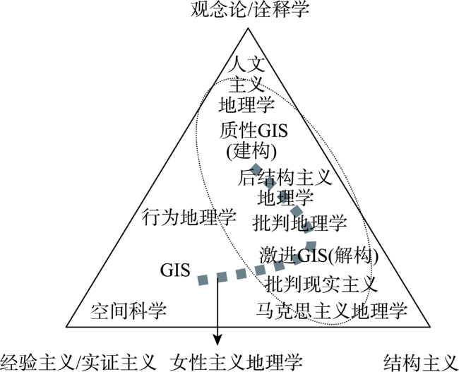
地图是地理学的基本语言,也是空间分析必不可少的工具。但长期以来,地图一直被视为一种客观中立的科学成果。受批判地理学的启发,批判制图学/GIS应运而生,其目标是阐明制图实践中所嵌入的话语、权力关系,挑战地图表征中未经检验却被认为是理所当然的假设。经历40余年的争论与磨合,这一研究领域初现轮廓,批判制图学/GIS大致形成2个研究方向:解构路径主要从制图主体身份和地图知识生产过程2个方面出发,分别剖析制图术与国家治理密不可分的联系及其内在的权力作用机制;建构路径主要借助协作制图和反制图手段以实现地图数据的再生产。国内批判制图学/GIS研究刚刚起步,需要继续吸收批判地理学成果,开展不同历史时期、不同类型地图的解构研究,也需要加强建构路径与解构路径的深度弥合,并面向公众开展更加开放、公正的地图应用研究,将研究成果积极应用于社会实践。
王韬 , 刘云刚 . 地图与制图术:国际批判制图学/GIS研究进展[J]. 地理科学进展, 2022 , 41(6) : 1097 -1108 . DOI: 10.18306/dlkxjz.2022.06.012
Maps are the basic language of geography and an indispensable tool for spatial analysis. But maps have long been seen as an objective, neutral scientific product. Inspired by critical geography, critical cartography/GIS emerged with the goal of elucidating the nature of discourse, power relations, and even the physical environment embedded in cartographic practice and challenging the untested but taken for granted assumptions in cartographic representation. After nearly 40 years of debates, this field of research has been gradually defined, and a blueprint of "hybrid geographies" has gradually emerged. Through the combination of various geographical methodologies, critical cartography/GIS has generally formed two research directions. The deconstruction approaches mainly start from the identity of cartographers and the production process of map knowledge, and analyze the inseparable relationship between "cartographicality" and national governance as well as the inherent mechanism of power. The construction approaches mainly explore the new production and representation of maps by means of collaborative mapping and counter-mapping. The research of critical cartography/GIS in China has just started, so it is necessary to continue to draw on the achievements of critical geography to carry out the deconstruction research of different types of maps in different historical periods, strengthen the convergence of construction path and deconstruction path, and actively participate in the social applications of research results.
Key words: critical cartography; GIS; power; knowledge production; collaborative mapping; counter-mapping
表1 批判地理学与GIS论战的3个阶段及主要特征Tab.1 Three stages and main features of the debate between critical geography and GIS |
| 阶段划分 | 论战核心内容 |
|---|---|
| 1983—1993年 | 第一轮论战,GIS被批判学者贴上“非智力”和假定客观的“实证主义”标签,其研究基础是事实数据而非具有价值的信息;GIS学者对其进行了强有力的回应,认为对方对“科学”缺乏深入理解 代表性文献:[16,22-23] |
| 1993—1998年 | 第二轮论战,GIS过度依赖的笛卡儿式几何空间仍被反复强调,此外批评者认为其代表了霸权主义,也使社会面临沦为监视社会的危险;与此同时,争论双方开始共同举办会议以弥合分歧 代表性文献:[24-25] |
| 1998—2001年 | 论战的第三阶段,争论双方均意识到GIS并不必然是实证主义的,它同样可以用于弹性的非决定论分析。双方的争论逐步让位于如何共同“重构”一个更具有社会责任感的GIS 代表性文献:[26-28] |
表2 批判制图学/GIS的分析框架Tab.2 Analytical framework of critical cartography/GIS |
| 权力表现 | 科学制图学/GIS | 批判制图学/GIS | |
|---|---|---|---|
| 激进制图学/GIS(解构) | 质性制图学/GIS(建构) | ||
| 地图的外在权力:谁拥有制作、传播与解释地图的权利? | “自上而下”倡导制图技术专业化致力于建立制图学/GIS学科知识体系 | 将“治理术”概念拓展到“制图术”,揭示专业化的制图知识背后无处不在的国家空间治理逻辑 | “自下而上”倡导制图实践的业余化公众参与致力于各类网络地理服务与新空间媒体的开发与开放 |
| 地图的内在权力:地图表达、声张或掩盖了谁的空间权利? | 认为地图是对空间的客观表征,空间信息可以通过“科学化”的语言得以完整表达 推崇数据的定量化 | 认为任何制图过程都是对客观现实的选择性表达 揭示地图强化了哪些主体的权力的同时压制了哪些群体的权力 | 重视艺术/非科学制图强化定性GIS (qualitative GIS)、反制图(counter-mappings)等非定量手段 |
| [1] |
|
| [2] |
|
| [3] |
|
| [4] |
|
| [5] |
|
| [6] |
丹尼斯·伍德. 地图的力量[M]. 王志弘, 李根芳, 魏庆嘉, 等译. 北京: 中国社会科学出版社, 2000.
[
|
| [7] |
|
| [8] |
|
| [9] |
|
| [10] |
Crampton J W: The political mapping of cyberspace[M]. Edinburgh, UK: Edinburgh University Press, 2003.
|
| [11] |
|
| [12] |
|
| [13] |
|
| [14] |
|
| [15] |
|
| [16] |
|
| [17] |
尼古拉斯·斯皮克曼. 和平地理学[M]. 刘愈之, 译. 北京: 商务印书馆, 1965.
[
|
| [18] |
|
| [19] |
|
| [20] |
|
| [21] |
|
| [22] |
|
| [23] |
|
| [24] |
|
| [25] |
|
| [26] |
|
| [27] |
|
| [28] |
|
| [29] |
|
| [30] |
|
| [31] |
|
| [32] |
|
| [33] |
|
| [34] |
|
| [35] |
|
| [36] |
|
| [37] |
|
| [38] |
马克·蒙莫尼尔. 会说谎的地图[M]. 黄义军, 译. 北京: 商务印书馆, 2012.
[
|
| [39] |
|
| [40] |
|
| [41] |
|
| [42] |
汤茂林, 黄展. Empirical Research到底是实证研究还是经验研究?兼论学术研究的分类[J]. 地理研究, 2020, 39(12): 2855-2860.
[
|
| [43] |
|
| [44] |
|
| [45] |
|
| [46] |
|
| [47] |
|
| [48] |
|
| [49] |
|
| [50] |
|
| [51] |
通猜·威尼差恭. 图绘暹罗: 一部国家地缘机体的历史[M]. 袁剑, 译. 南京: 译林出版社, 2016.
[
|
| [52] |
|
| [53] |
|
| [54] |
|
| [55] |
|
| [56] |
|
| [57] |
|
| [58] |
|
| [59] |
|
| [60] |
|
| [61] |
|
| [62] |
|
| [63] |
|
| [64] |
|
| [65] |
|
| [66] |
|
| [67] |
|
| [68] |
|
| [69] |
|
| [70] |
|
| [71] |
|
| [72] |
|
| [73] |
|
| [74] |
|
| [75] |
|
| [76] |
|
| [77] |
|
| [78] |
|
| [79] |
|
| [80] |
|
| [81] |
|
| [82] |
|
| [83] |
|
| [84] |
|
| [85] |
|
| [86] |
|
| [87] |
|
| [88] |
|
| [89] |
|
| [90] |
|
| [91] |
|
| [92] |
|
| [93] |
|
| [94] |
|
| [95] |
安传艳, 李同昇. 地图表征的权力运作机制: 建构的知识话语[J]. 地理研究, 2019, 38(8): 2099-2112.
[
|
| [96] |
|
| [97] |
张景奇, 史文宝, 修春亮. POI数据在中国城市研究中的应用[J]. 地理科学, 2021, 41(1): 140-148.
[
|
| [98] |
关美宝. 超越地理学二元性: 混合地理学的思考[J]. 地理科学进展, 2013, 32(9): 1307-1315.
[
|
| [99] |
叶超, 塔娜. 重建地方: 人文地理与GIS结合研究的路径[J]. 地理科学进展, 2020, 39(8): 1249-1259.
[
|
| [100] |
何光强, 宋秀琚. 地图投影与全球地缘政治分析: 一种空间认知的视角[J]. 人文地理, 2014, 29(2): 113-122.
[
|
| [101] |
何光强. 二战期间美国地缘战略空间观念变迁: 基于地图投影的视角[J]. 地理科学, 2019, 39(5): 714-725.
[
|
| [102] |
谭一洺, 柴彦威, 关美宝. 地理背景的不确定性对时空行为模式分析的影响: 基于西宁市的实证研究[J]. 地理学报, 2017, 72(4): 657-670.
[
|
| [103] |
刘云刚, 苏海宇. 社会地图研究综述与展望[J]. 地理科学进展, 2015, 34(7): 800-808.
[
|
| [104] |
|
| [105] |
|
/
| 〈 |
|
〉 |