
基于地貌分区的陕西省区域生态风险时空演变
|
刘迪(1993— ),男,河南郑州人,博士生,主要从事综合自然地理与景观生态研究。E-mail:lcx@stumail.nwu.edu.cn |
收稿日期: 2019-03-14
要求修回日期: 2019-05-16
网络出版日期: 2020-04-28
基金资助
国家自然科学基金项目(41671086)
国家自然科学基金项目(41871185)
版权
Spatiotemporal changes of regional ecological risks in Shaanxi Province based on geomorphologic regionalization
Received date: 2019-03-14
Request revised date: 2019-05-16
Online published: 2020-04-28
Supported by
National Natural Science Foundation of China(41671086)
National Natural Science Foundation of China(41871185)
Copyright
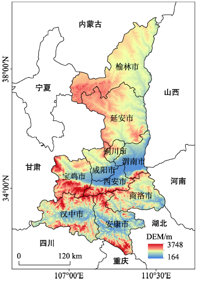
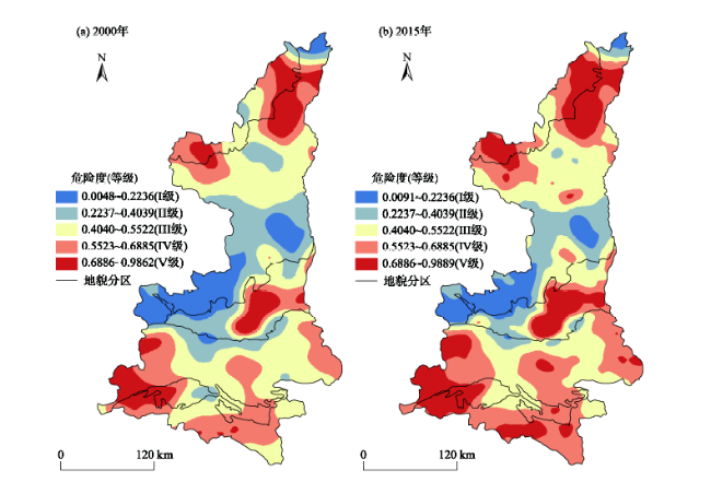
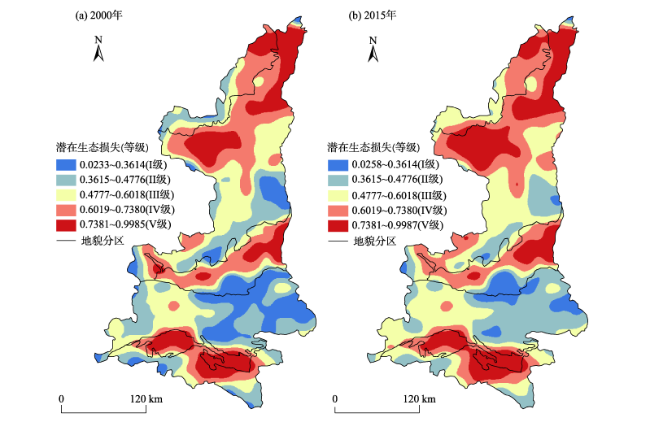
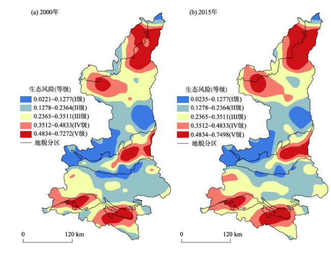
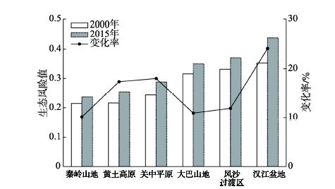
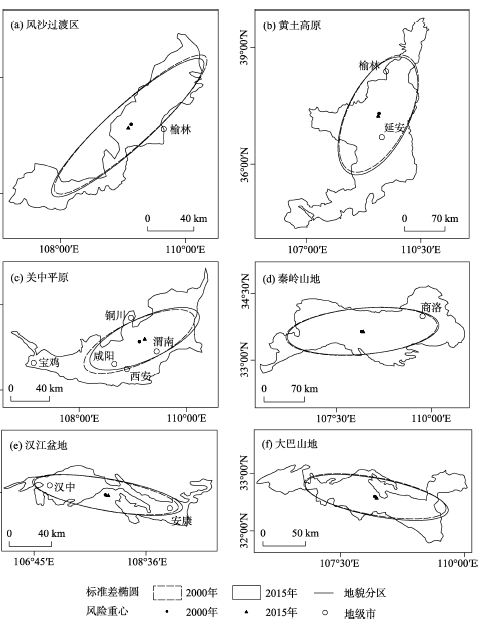
论文采用“概率—损失”二维风险模型解构陕西省区域生态风险,基于地貌分区视角识别多源风险类型的同时以景观格局与生态系统服务价值为关联要素合成潜在生态损失,在此基础上分析了陕西省2000—2015年单一风险要素及区域生态风险的时空分异,并基于地貌分区视角结合重心模型探讨了生态风险的时空迁移。结果如下:① 2000、2015年陕西省多源危险度分别为0.3837、0.4558,上升18.79%,大致呈现南北高、中间低的空间格局,沿南北轴线呈现“W型”展布;潜在生态损失分别为0.5537、0.6270,上升13.24%,除高原南部与秦岭东部山区外,生态损失均呈现高值;区域生态风险分别为0.2429、0.2865,上升17.95%,空间上呈现“三高夹两低”的分布格局。② 从时序变化来看,秦巴山地保持较低风险且风险变化率较小;黄土高原与风沙过渡区变化率处于中等,后者面临较高风险;汉江盆地风险最高,该区域与关中平原分别为风险变化率的首位与次位。从生态风险重心变化趋势看,黄土高原与风沙过渡区重心均向西南移动,关中平原与秦岭山地重心东移趋势明显,汉江盆地与大巴山地重心跃向东南。
刘迪 , 陈海 , 耿甜伟 , 张行 , 史琴琴 . 基于地貌分区的陕西省区域生态风险时空演变[J]. 地理科学进展, 2020 , 39(2) : 243 -254 . DOI: 10.18306/dlkxjz.2020.02.006
Land surface elements such as land use / land cover are in constant change and dynamic balance, driving the changes of global ecological processes and forming the regional differentiation of landscape, which cause many ecological risks under multi-source stresses. Based on a probability-loss risk model, a multiple hazards and potential ecological damage approach was used to construct a regional ecological risk evaluation system of Shaanxi Province. After identifying multiple hazard types from the perspective of geomorphologic regionalization, potential ecological damages were synthesized by taking landscape pattern and ecosystem services value losses as related factors. The spatial and temporal differentiation of individual risk factors and regional ecological risks in Shaanxi Province between 2000 and 2015 were analyzed. Meanwhile, the spatial and temporal changes of ecological risks were demonstrated from the perspective of geomorphologic regionalization and risk gravity model. Several conclusions were drawn from this analysis: 1) In 2000 and 2015, the multiple hazards index values of Shaanxi Province were 0.3837 and 0.4558, respectively, with an increase of 18.79%. Multiple hazards presented the spatial pattern of high in the north and south and low in the middle, with a W-shaped distribution along the north-south axis. Potential ecological damages were 0.5537 and 0.6270, up by 13.24%. Except for the southern part of the Loess Plateau and the eastern part of the Qinling Mountains, potential ecological damages were high. The regional ecological risks were 0.2429 and 0.2865, rising by 17.95%, and presented a spatial distribution pattern of "three high value areas sandwiched by two low value areas". 2) The ecological risks of the Qinling-Daba Mountains were low and the change rate of risks was small. The change rate of risks of the Loess Plateau and the sandification transitional zone was moderate, and the latter was facing a high risk. The Hanjiang Basin had the highest risks and the Hanjiang Basin and Guanzhong Plain took the first and second places in the change rate of risks, respectively. The risk gravity centers of the Loess Plateau and the sandification transitional zone both moved to the southwest, the risk gravity centers of the Guanzhong Plain and the Qinling Mountains moved significantly to the east, and the risk gravity centers of the Hanjiang Basin and the Daba Mountains jumped to the southeast.
表1 多源危险度评估结构Tab.1 Multiple hazard assessment structure |
| 地貌类型 | 评估要素 | 权重 |
|---|---|---|
| 秦巴山地/汉江盆地 | 滑坡 | 0.1276 |
| 山洪 | 0.1874 | |
| 黄土高原/风沙过渡区 | 干旱 | 0.0944 |
| 土壤侵蚀 | 0.1408 | |
| 全区 | 城市化水平 | 0.2133 |
| 工农业活动 | 0.2365 |
表2 陕西省单位面积生态系统服务价值Tab.2 The value of ecosystem services per unit area in Shaanxi Province (万元/km2) |
| 一级类型 | 二级类型 | 耕地 | 林地 | 草地 | 水域 |
|---|---|---|---|---|---|
| 供给服务 | 食物生产 | 37.98 | 8.10 | 10.61 | 22.34 |
| 原料生产 | 2.51 | 18.43 | 15.64 | 6.42 | |
| 水资源供给 | -73.46 | 9.49 | 8.65 | 231.56 | |
| 调节服务 | 气体调节 | 31.01 | 60.61 | 55.02 | 21.50 |
| 气候调节 | 15.92 | 181.56 | 145.53 | 63.96 | |
| 净化环境 | 4.74 | 53.91 | 48.04 | 155.02 | |
| 水文调节 | 75.97 | 132.40 | 106.70 | 2 855.90 | |
| 支持服务 | 土壤保持 | 0.27 | 74.02 | 67.03 | 25.97 |
| 维持养分循环 | 5.30 | 5.58 | 5.02 | 0.95 | |
| 生物多样性 | 5.86 | 67.31 | 60.89 | 71.22 | |
| 文化服务 | 美学景观 | 2.51 | 29.60 | 26.81 | 52.79 |
图2 2000—2015年陕西省多源危险度空间分布Fig.2 Spatial distribution of multiple hazards in Shaanxi Province, 2000-2015 |
图3 陕西省2000—2015年潜在生态损失空间分布Fig.3 Spatial distribution of potential ecological damage in Shaanxi Province, 2000-2015 |
| [1] |
周汝佳, 张永战, 何华春 . 基于土地利用变化的盐城海岸带生态风险评价[J]. 地理研究, 2016,35(6):1017-1028.
[
|
| [2] |
郑度, 吴绍洪, 尹云鹤 , 等. 全球变化背景下中国自然地域系统研究前沿[J]. 地理学报, 2016,71(9):1475-1483.
[
|
| [3] |
彭建, 杜悦悦, 刘焱序 , 等. 从自然区划、土地变化到景观服务: 发展中的中国综合自然地理学[J]. 地理研究, 2017,36(10):1819-1833.
[
|
| [4] |
张小飞, 彭建, 王仰麟 , 等. 全球变化背景下景观生态适应性特征[J]. 地理科学进展, 2017,36(9):1167-1175.
[
|
| [5] |
|
| [6] |
彭建, 党威雄, 刘焱序 , 等. 景观生态风险评价研究进展与展望[J]. 地理学报, 2015,70(4):664-677.
[
|
| [7] |
曹祺文, 张曦文, 马洪坤 , 等. 景观生态风险研究进展及基于生态系统服务的评价框架: ESRISK[J]. 地理学报, 2018,73(5):843-855.
[
|
| [8] |
|
| [9] |
孟晖, 李春燕, 张若琳 , 等. 京津冀地区县域单元地质灾害风险评估[J]. 地理科学进展, 2017,36(3):327-334.
[
|
| [10] |
周启刚, 张晓媛, 王兆林 . 基于正态云模型的三峡库区土地利用生态风险评价[J]. 农业工程学报, 2014,30(23):289-297.
[
|
| [11] |
|
| [12] |
徐羽, 钟业喜, 冯兴华 , 等. 鄱阳湖流域土地利用生态风险格局[J]. 生态学报, 2016,36(23):7850-7857.
[
|
| [13] |
胡金龙, 周志翔, 滕明君 . 基于土地利用变化的典型喀斯特流域生态风险评估: 以漓江流域为例[J]. 应用生态学报, 2017,28(6):2003-2012.
[
|
| [14] |
刘春艳, 张科, 刘吉平 . 1976—2013年三江平原景观生态风险变化及驱动力[J]. 生态学报, 2018,38(11):3729-3740.
[
|
| [15] |
王鹏, 王亚娟, 刘小鹏 , 等. 基于景观结构的生态移民安置区生态风险评价: 以宁夏红寺堡区为例[J]. 生态学报, 2018,38(8):2672-2682.
[
|
| [16] |
吕乐婷, 张杰, 孙才志 , 等. 基于土地利用变化的细河流域景观生态风险评估[J]. 生态学报, 2018,38(16):5952-5960.
[
|
| [17] |
|
| [18] |
刘迪, 陈海, 梁小英 , 等. 黄土丘陵沟壑区生态风险动态变化及其地形梯度分析: 以陕西省米脂县为例[J]. 生态学报, 2018,38(23):8584-8592.
[
|
| [19] |
哈凯, 丁庆龙, 门明新 , 等. 山地丘陵区土地利用分布及其与地形因子关系: 以河北省怀来县为例[J]. 地理研究, 2015,34(5):909-921.
[
|
| [20] |
赵岩洁, 李阳兵, 邵景安 . 基于土地利用变化的三峡库区小流域生态风险评价: 以草堂溪为例[J]. 自然资源学报, 2013,28(6):944-956.
[
|
| [21] |
彭建, 谢盼, 刘焱序 , 等. 低丘缓坡建设开发综合生态风险评价及发展权衡: 以大理白族自治州为例[J]. 地理学报, 2015,70(11):1747-1761.
[
|
| [22] |
|
| [23] |
孙智斌, 高敏华, 崔雪锋 . 基于遥感与GIS的天山北坡经济带2000—2015年土地利用动态变化研究[J]. 北京师范大学学报(自然科学版), 2018,54(3):397-404.
[
|
| [24] |
许妍, 高俊峰, 郭建科 . 太湖流域生态风险评价[J]. 生态学报, 2013,33(9):2896-2906.
[
|
| [25] |
|
| [26] |
方广玲, 香宝, 王宝良 , 等. 苏南经济快速发展地区人类活动生态风险评价: 以镇江市丹徒区为例[J]. 应用生态学报, 2014,25(4):1076-1084.
[
|
| [27] |
刘焱序, 王仰麟, 彭建 , 等. 基于生态适应性循环三维框架的城市景观生态风险评价[J]. 地理学报, 2015,70(7):1052-1067.
[
|
| [28] |
徐勇, 孙晓一, 汤青 . 陆地表层人类活动强度: 概念、方法及应用[J]. 地理学报, 2015,70(7):1068-1079.
[
|
| [29] |
汪翡翠, 汪东川, 张利辉 , 等. 京津冀城市群土地利用生态风险的时空变化分析[J]. 生态学报, 2018,38(12):4307-4316.
[
|
| [30] |
杜悦悦, 彭建, 赵士权 , 等. 西南山地滑坡灾害生态风险评价: 以大理白族自治州为例[J]. 地理学报, 2016,71(9):1544-1561.
[
|
| [31] |
虞燕娜, 朱江, 吴绍华 , 等. 多风险源驱动下的土地生态风险评价: 以江苏省射阳县为例[J]. 自然资源学报, 2016,31(8):1264-1274.
[
|
| [32] |
谢高地, 张彩霞, 张雷明 , 等. 基于单位面积价值当量因子的生态系统服务价值化方法改进[J]. 自然资源学报, 2015,30(8):1243-1254.
[
|
| [33] |
郭少壮, 白红英, 孟清 , 等. 1980—2015年秦岭地区景观格局变化及其对人为干扰的响应[J]. 应用生态学报, 2018,29(12):4080-4088.
[
|
/
| 〈 |
|
〉 |