
基于自然区块的城市热环境空间分异性研究
|
杨智威(1996— ),男,福建三明人,硕士生,主要研究方向为城市生态与遥感应用。E-mail: yangzw9615@163.com |
收稿日期: 2019-02-18
要求修回日期: 2019-03-11
网络出版日期: 2019-12-28
基金资助
广东省自然科学基金项目(2016A030313551)
国家自然科学基金项目(41671430)
国家自然科学基金项目(41771127)
版权
Spatial variability of urban thermal environment based on natural blocks
Received date: 2019-02-18
Request revised date: 2019-03-11
Online published: 2019-12-28
Supported by
Natural Science Foundation of Guangdong Province(2016A030313551)
National Natural Science Foundation of China(41671430)
National Natural Science Foundation of China(41771127)
Copyright
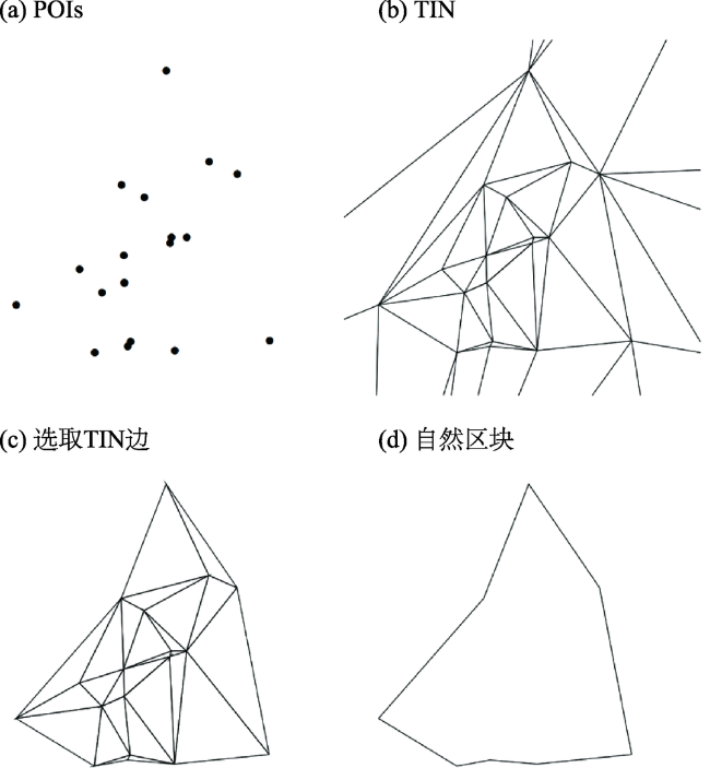
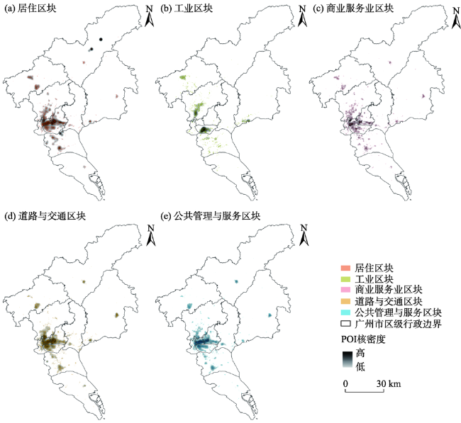
通过有效解决建设用地子类划分,实现定量评价城市热环境的空间分异性,对改善城市生态环境、实现城市化的健康发展具有重要的意义和科学价值。论文以广州市为例,参考自然城市的概念,基于5类兴趣点(Point Of Interest,POI)开放数据,结合城市建设用地分类标准,构建5类自然区块;在Landsat 8遥感影像地表温度反演的基础上,计算分析自然区块下地表热场等级分布格局、热场平均值及热环境足迹范围,以对城市热环境空间分异性进行评价。研究表明:① 自然区块的构建,能准确地反映各类POI数据空间分布情况,能够实现对建设用地子类型的划分;② 5类自然区块内部地表热场等级均以高温像元为主,但等级分布具有显著差异。同时,自然区块的热场平均值由高到低的排序为:工业区块>商业服务业区块>交通与道路区块>居住区块>公共管理与服务区块;③ 自然区块形成的高温集聚区,存在热量扩散现象,实际影响范围大于其物理边界,5类自然区块的热环境足迹范围具有分异性。热环境足迹影响范围由大到小排序为:工业区块>商业服务业区块>居住区块>道路与交通区块>公共管理与服务区块。研究结果可为微观尺度上分析城市热环境、改善城市生态环境、实现城市化的健康发展提供科学依据。
杨智威 , 陈颖彪 , 吴志峰 , 千庆兰 , 黄清瑶 . 基于自然区块的城市热环境空间分异性研究[J]. 地理科学进展, 2019 , 38(12) : 1944 -1956 . DOI: 10.18306/dlkxjz.2019.12.010
Addressing the issue of subdivision of construction land for quantitative evaluation of spatial variability of urban thermal environment is of great significance for improving the ecological environment of cities and realizing the healthy development of urban areas. In this study, we used Landsat 8 remote sensing imageries to retrieve the surface temperature data of Guangzhou City. Based on the concept of natural city combined with the classification standard of urban construction land, we identified five types of natural blocks based on the open data of point of interest (POI). On this basis, the distribution pattern of land surface heat field levels, thermal field average value of natural blocks, and thermal environment footprint range were calculated and analyzed to evaluate the spatial variability of the urban thermal environment of the city. The results show that: 1) The identification of natural blocks may accurately reflect the spatial distribution of all kinds of POI and realize a meaningful division of the sub-types of construction land. 2) Land surface heat field in the five types of natural blocks was dominated by high temperature pixels (more than 90%), and the distribution range of low temperature pixels is small (less than 1%). But the distribution of the heat field levels was significantly different across the natural blocks. In the residential, road and traffic, and public management and service natural blocks, the proportion of land surface heat field levels was similar; the proportion of mesothermal pixels in the commercial and services natural block was less than half of the above three types of natural blocks. The proportion of high temperature pixels in the industrial natural block was the highest, reaching 99%, and there was no low temperature pixel. The order of thermal field average value of natural blocks from high to low is: industrial natural block > commercial and services natural block > road and traffic natural block > residential natural block > public management and service natural block. 3) Heat diffusion exists in the high temperature agglomeration area formed by natural blocks, and the actual influence range is larger than its physical boundary. The thermal environment footprint range of the five types of natural blocks was different. The thermal environment footprint of industrial natural block was the widest, and the 6th ring buffer zone was still in the scope of impact. While the thermal environment footprint of public management and service natural block only affects the 2nd ring buffer zone, compared with the other four types of natural blocks, the effect of heat diffusion was not significant. The influence range of thermal environment footprint from large to small is: industrial natural block > commercial and services natural block > residential natural block > road and traffic natural block > public management and service natural block. The result of this study may provide some scientific basis for the analysis of urban thermal environment, the improvement of urban ecological environment, and the healthy development of urbanization.
表1 均值-标准差法划分地表热场等级的方法Tab.1 Usage of mean-standard deviation method to divide land surface heat fields |
| 地表热场等级 | 划分方法 |
|---|---|
| Ⅰ 级 | |
| Ⅱ 级 | |
| Ⅲ 级 | |
| Ⅳ 级 | |
| Ⅴ 级 | |
| Ⅵ 级 | |
| Ⅶ 级 |
注:T表示地表温度反演值,A为研究区地表温度平均值,SD为地表温度标准差。 |
表2 地表热场等级统计Tab.2 Statistics of land surface heat field levels |
| 地表热场等级 | 原始数据 | 剔除干扰后数据 | |||
|---|---|---|---|---|---|
| 数量 | 比例/% | 数量 | 比例/% | ||
| Ⅰ 级 | 19004 | 0.23 | 4040 | 0.07 | |
| Ⅱ 级 | 474344 | 5.79 | 66110 | 1.10 | |
| Ⅲ 级 | 1917824 | 23.39 | 678199 | 11.33 | |
| Ⅳ 级 | 3332268 | 40.65 | 2812505 | 46.98 | |
| Ⅴ 级 | 1822772 | 22.24 | 1797897 | 30.03 | |
| Ⅵ 级 | 549189 | 6.70 | 546626 | 9.13 | |
| Ⅶ 级 | 81771 | 1.00 | 81553 | 1.36 | |
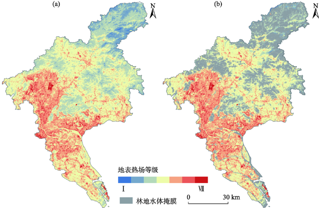
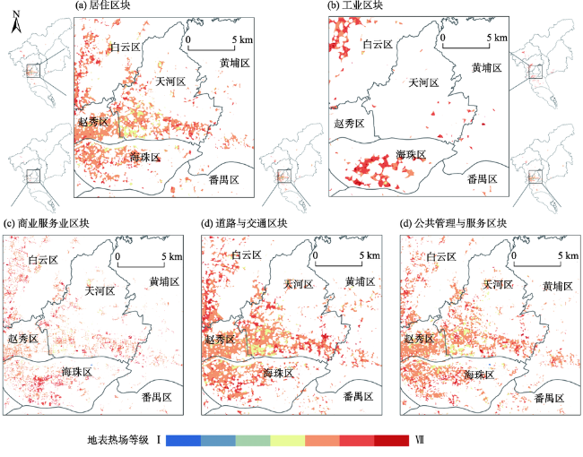
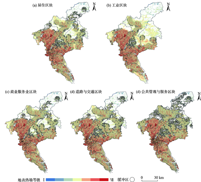
图4 自然区块下地表热场等级空间分布格局Fig.4 Spatial distribution of land surface heat field levels in natural blocks |
表3 自然区块下地表热场等级数量统计Tab.3 Statistics of the number of land surface heat field levels in natural blocks |
| 地表热场等级 | 居住区块 | 工业区块 | 商业服务业区块 | 道路与交通区块 | 公共管理与服务区块 | |||||||||
|---|---|---|---|---|---|---|---|---|---|---|---|---|---|---|
| 数量 | 占比/% | 数量 | 占比/% | 数量 | 占比/% | 数量 | 占比/% | 数量 | 占比/% | |||||
| Ⅰ 级 | 0 | 0 | 0 | 0 | 22 | 0.03 | 4 | <0.01 | 39 | 0.03 | ||||
| Ⅱ 级 | 0 | 0 | 0 | 0 | 1 | <0.01 | 27 | 0.01 | 6 | <0.01 | ||||
| Ⅲ 级 | 22 | 0.01 | 0 | 0 | 13 | 0.02 | 96 | 0.05 | 59 | 0.04 | ||||
| Ⅳ 级 | 11546 | 7.77 | 430 | 0.43 | 2692 | 3.22 | 12477 | 6.66 | 11401 | 7.34 | ||||
| Ⅴ 级 | 98683 | 66.43 | 35868 | 36.16 | 47015 | 56.20 | 118375 | 63.21 | 106785 | 68.78 | ||||
| Ⅵ 级 | 37744 | 25.41 | 57604 | 58.07 | 31997 | 38.25 | 54543 | 29.12 | 36144 | 23.28 | ||||
| Ⅶ 级 | 553 | 0.37 | 5300 | 5.53 | 1923 | 2.30 | 1755 | 0.94 | 816 | 0.53 | ||||
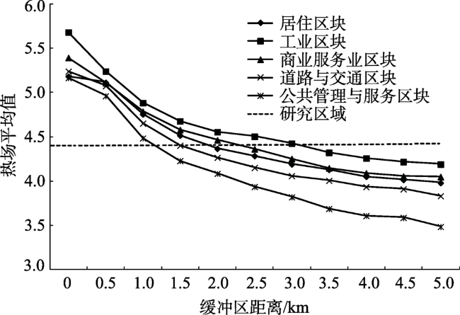
表4 自然区块缓冲区下热场平均值和面积统计Tab.4 Statistics of thermal field average value and area in the buffer zones under natural blocks |
| 缓冲区距离/m | 热场平均值 | ||||
|---|---|---|---|---|---|
| 居住 区块 | 工业 区块 | 商业服务业区块 | 道路与 交通区块 | 公共管理 与服务区块 | |
| 500 | 5.116 | 5.242 | 5.111 | 5.077 | 4.963 |
| 1000 | 4.758 | 4.886 | 4.788 | 4.654 | 4.486 |
| 1500 | 4.518 | 4.679 | 4.581 | 4.405 | 4.231 |
| 2000 | 4.369 | 4.558 | 4.465 | 4.268 | 4.087 |
| 2500 | 4.287 | 4.505 | 4.365 | 4.154 | 3.938 |
| 3000 | 4.193 | 4.428 | 4.254 | 4.061 | 3.822 |
| 3500 | 4.131 | 4.324 | 4.149 | 4.008 | 3.689 |
| 4000 | 4.053 | 4.261 | 4.091 | 3.937 | 3.611 |
| 4500 | 4.016 | 4.219 | 4.056 | 3.911 | 3.589 |
| 5000 | 3.983 | 4.192 | 4.051 | 3.834 | 3.487 |
| [1] |
陈超, 周广胜 . 2013. 1961—2010年桂林气温和地温的变化特征[J]. 生态学报, 33(7):2043-2053.
[
|
| [2] |
陈康林, 龚建周, 陈晓越 , 等. 2016. 广州城市绿色空间与地表温度的格局关系研究[J]. 生态环境学报, 25(5):842-849.
[
|
| [3] |
陈世莉, 李郇, 赖安琪 , 等. 2017. 广佛同城化发展的热岛效应研究[J]. 地理科学进展, 36(6):720-731.
[
|
| [4] |
陈松林, 王天星 . 2009. 等间距法和均值-标准差法界定城市热岛的对比研究[J]. 地球信息科学学报, 11(2):145-150.
[
|
| [5] |
陈蔚珊, 柳林, 梁育填 . 2016. 基于POI数据的广州零售商业中心热点识别与业态集聚特征分析[J]. 地理研究, 35(4):703-716.
[
|
| [6] |
关雪峰, 曾宇媚 . 2018. 时空大数据背景下并行数据处理分析挖掘的进展及趋势[J]. 地理科学进展, 37(10):1314-1327.
[
|
| [7] |
郭冠华, 吴志峰, 刘晓南 . 2015. 城市热环境季相变异及与非渗透地表的定量关系分析: 以广州市中心区为例[J]. 生态环境学报, 24(2):270-277.
[
|
| [8] |
浩飞龙, 王士君, 冯章献 , 等. 2018. 基于POI数据的长春市商业空间格局及行业分布[J]. 地理研究, 37(2):366-378.
[
|
| [9] |
李元征, 尹科, 周宏轩 , 等. 2016. 基于遥感监测的城市热岛研究进展[J]. 地理科学进展, 35(9):1062-1074.
[
|
| [10] |
廖伟华, 聂鑫 . 2017. 基于大数据的城市服务业空间关联分析[J]. 地理科学, 37(9):1310-1317.
[
|
| [11] |
刘嘉慧, 赵小锋, 林剑艺 . 2018. 基于地表能量平衡的厦门岛城市功能区人为热排放分析[J]. 地球信息科学学报, 20(7):1026-1036.
[
|
| [12] |
彭文甫, 周介铭, 罗怀良 , 等. 2011. 城市土地利用与地面热效应时空变化特征的关系: 以成都市为例[J]. 自然资源学报, 26(10):1738-1749.
[
|
| [13] |
钱乐祥, 丁圣彦 . 2005. 珠江三角洲土地覆盖变化对地表温度的影响[J]. 地理学报, 60(5):761-770.
[
|
| [14] |
覃志豪 ,
[
|
| [15] |
覃志豪 ,
[
|
| [16] |
孙然好, 王业宁, 陈婷婷 . 2017. 人为热排放对城市热环境的影响研究展望[J]. 生态学报, 37(12):3991-3997.
[
|
| [17] |
王琳, 徐涵秋, 李胜 . 2018. 重钢重工业区迁移对区域生态的影响研究[J]. 遥感技术与应用, 33(3):387-397.
[
|
| [18] |
徐智邦, 周亮, 蓝婷 , 等. 2018. 基于POI数据的巨型城市消防站空间优化: 以北京市五环内区域为例[J]. 地理科学进展, 37(4):535-546.
[
|
| [19] |
许泽宁, 高晓路 . 2016. 基于电子地图兴趣点的城市建成区边界识别方法[J]. 地理学报, 71(6):928-939.
[
|
| [20] |
杨敏, 杨贵军, 王艳杰 , 等. 2018. 北京城市热岛效应时空变化遥感分析[J]. 国土资源遥感, 30(3):213-223.
[
|
| [21] |
杨智威, 陈颖彪, 吴志峰 , 等. 2018. 粤港澳大湾区建设用地扩张与城市热岛扩张耦合态势研究[J]. 地球信息科学学报, 20(11):1592-1603.
[
|
| [22] |
张棋斐, 文雅, 吴志峰 , 等. 2018. 高密度建成区湖泊水体的热缓释效应及其季相差异: 以广州市中心城区为例[J]. 生态环境学报, 27(7):1323-1334.
[
|
| [23] |
祝新明, 王旭红, 周永芳 , 等. 2017. 建成区扩张下的西安市热环境空间分异性[J]. 生态学杂志, 36(12):3574-3583.
[
|
| [24] |
|
| [25] |
|
| [26] |
|
| [27] |
|
| [28] |
|
| [29] |
|
| [30] |
|
| [31] |
|
| [32] |
|
| [33] |
|
| [34] |
|
| [35] |
|
| [36] |
|
| [37] |
|
| [38] |
|
| [39] |
|
| [40] |
|
| [41] |
|
| [42] |
|
/
| 〈 |
|
〉 |