
长江立体化综合交通运输走廊的空间组织模式
作者简介:王成金(1975-),男,山东沂水人,博士,副研究员,主要从事交通地理与区域发展研究,E-mail: cjwang@igsnrr.ac.cn。
网络出版日期: 2015-11-25
基金资助
2015年中国科学院学部咨询评议项目“长江经济带重大战略问题研究”
国家自然科学基金项目(41571113,41171108)
Spatial organization pattern of the Yangtze River integrated transport corridor
Online published: 2015-11-25
Copyright
王成金 , 程佳佳 , 马丽 . 长江立体化综合交通运输走廊的空间组织模式[J]. 地理科学进展, 2015 , 34(11) : 1441 -1448 . DOI: 10.18306/dlkxjz.2015.11.011
The Yangtze River Economic Belt (YREB) has been specified as a national development strategy. In order to promote the socioeconomic development of YREB, an integrated transportation system based on the golden waterway should be improved. This article constructed a spatial mode of inland river integrated transport corridor, described its features with respect to the spatial system, node structure, function differentiation, transportation organization, and international connections. Moreover, the article analyzed the current development of the Yangtze River transport corridor and identified important bottlenecks and demand. Based on the above study, this article emphasized the spatial organization mode of the Yangtze River integrated transport corridor, including water channel network, port layout and transport system of bulk cargoes, function differentiation and distribution network, and structure of the integrated transport hubs and an open transport organization.
Tab.1 Transport infrastructure of the Yangtze River Economic Belt (YREB)表1 长江经济带交通设施基本情况 |
| 指标 | 1978年 | 2013年 | 增长倍数 |
|---|---|---|---|
| 一、内河航道里程/万km | 8.9 | 8.9 | — |
| 高等级航道里程/万km | 0.23 | 0.67 | 1.9 |
| 二、铁路营业里程/万km | 1.4 | 2.96 | 1.1 |
| 高速铁路里程/万km | 0 | 0.4 | — |
| 复线率/% | 11.9 | 49.8 | 3.2 |
| 电化率/% | 2.7 | 69.7 | 24.8 |
| 三、公路通车里程/万km | 35 | 189.3 | 4.4 |
| 国家高速公路里程/万km | 0 | 3.2 | — |
| 四、输油(气)管道里程/万km | 0.06 | 4.4 | 72.3 |
| 五、城市轨道交通营业里程/km | 0 | 1089 | — |
| 六、民用运输机场数/个 | 20 | 74 | 2.7 |
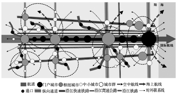
Fig.1 Spatial pattern of the three-dimensional integrated transport corridor图1 立体化综合交通运输走廊空间模式 |
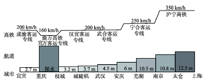
Fig.2 Depth of the main channel of the Yangtze River and speed of the Shanghai-Wuhan-Chengdu High-Speed Railway图2 长江主航道各区段水深、沪汉蓉高铁各区段运行速度示意图 |
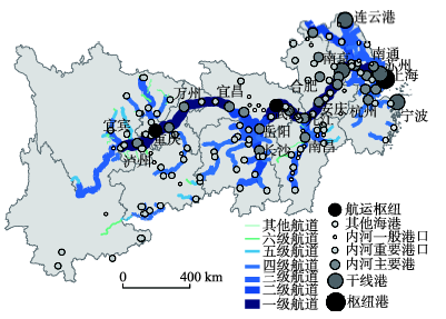
Fig.3 Layout of the main inland waterways and ports of the Yangtze River Economic Belt (YREB)图3 长江立体化综合交通走廊的航道主轴与港口布局 |
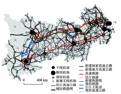
Fig.4 Layout of the railways, highways, and airports of the Yangtze River Economic Belt (YREB)图4 长江经济带铁路、公路和机场布局体系 |
The authors have declared that no competing interests exist.
| 1 |
[
|
| 2 |
[
|
| 3 |
[
|
| 4 |
[
|
| 5 |
[
|
| 6 |
[
|
| 7 |
[
|
| 8 |
[
|
| 9 |
[
|
| 10 |
[
|
| 11 |
[
|
| 12 |
[
|
| 13 |
[
|
| 14 |
[
|
| 15 |
[
|
| 16 |
[
|
| 17 |
[
|
| 18 |
[
|
| 19 |
|
| 20 |
|
/
| 〈 |
|
〉 |