
利用SAR影像时间序列的耕地提取研究
作者简介:钟礼山(1991-),男,四川广安人,硕士研究生,主要研究方向为遥感时空数据挖掘、LiDAR三维重建等,E-mail: zhonglishan@foxmail.com。
网络出版日期: 2015-07-10
基金资助
国家科技支撑项目课题(2012BAH28B02)
国家自然科学基金项目(41371017)
Cropland extraction using SAR time series image
Online published: 2015-07-10
Copyright
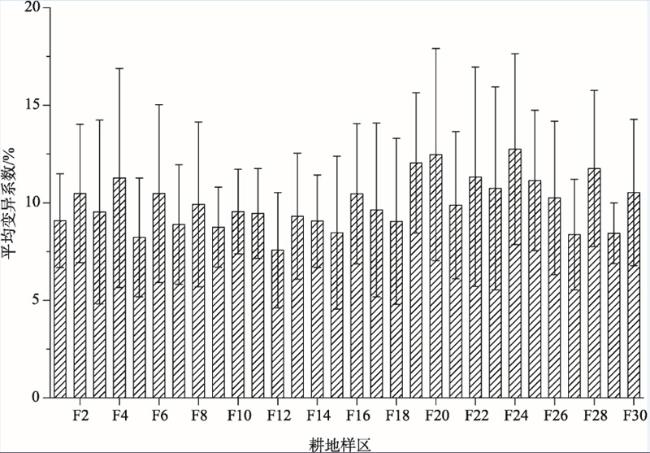
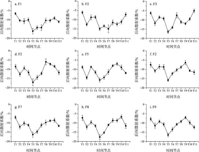
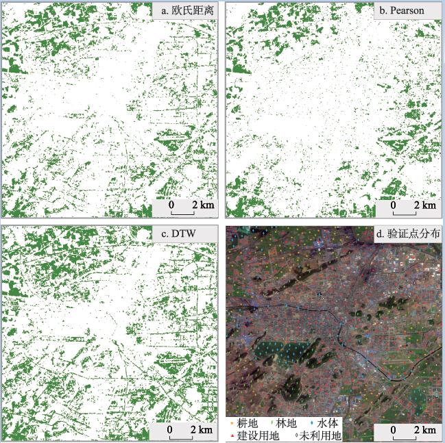
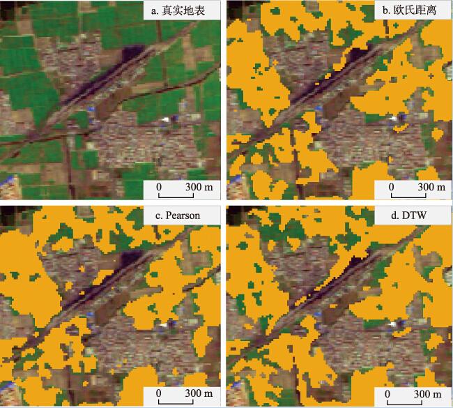
卫星遥感是耕地资源调查的一种重要技术手段,利用遥感时间序列数据进行耕地提取具有很强的实践意义。光学遥感成像过程易受光照和大气条件影响,在云雨多发地区所能获取的可用数据十分有限;合成孔径雷达(SAR)能够全天时、全天气进行对地观测,但受斑点噪声影响,少见利用其构建时间序列进行信息提取的研究。本文研究了SAR影像时间序列在耕地提取中的适用性,利用江苏省徐州市2009年12月-2010年12月共11景ENVISAT ASAR 影像构建时间序列,目视选取30个5像元×5像元大小的耕地样区,分别统计样区内(相邻位置)与样区间(不同位置)耕地时域后向散射特征的一致性(变异系数);然后利用欧氏距离法、相关系数法以及动态时间弯曲法(DTW)进行研究区的耕地提取。结果显示:相邻位置耕地像元后向散射特性较为一致,平均变异系数为9.96%;不同位置耕地像元后向散射特性一致性也较好,平均变异系数为15.27%。在所选的3种方法中,相关系数法耕地提取精度最高,正确率与完整率分别为86.25%与80.70%;欧氏距离法精度次之,正确率与完整率分别为76.40%与71.93%;DTW效果较差,正确率和完整率分别为62.15%和77.78%。SAR影像时间序列作为一种新的数据组织形式,可用于耕地的有效提取。
钟礼山 , 李满春 , 伍阳 , 夏南 , 程亮 . 利用SAR影像时间序列的耕地提取研究[J]. 地理科学进展, 2015 , 34(7) : 830 -839 . DOI: 10.18306/dlkxjz.2015.07.005
Satellite remote sensing is an important technique for cropland resources survey, while time series of remote sensing images, particularly, are of great practical significance for cropland extraction. Optical remote sensing imagery is largely affected by illumination and atmospheric conditions, which limits available satellite images within a year, especially where cloudy or rainy weather frequently occurs. Synthetic Aperture Radar (SAR), on the other hand, is able to acquire data throughout the day under any weather condition. However, owing to the influence of speckle noise, very little work has been done to use SAR image time series for feature extraction. This study examines the applicability of SAR image time series for cropland extraction, and Xuzhou City in Jiangsu Province was chosen as the study area. A total of 11 ENVISAT ASAR images covering the study area and dated from December 2009 to December 2010 were selected to establish a SAR time series as experimental data. Thirty cropland sampling regions with the size of 5 pixels × 5 pixels were visually chosen to calculate the consistency of cropland backscatter signatures in the temporal domain, at both neighboring location (inside each sampling region) and remote location (beyond the sampling regions). Euclidean distance method, correlation method, and dynamic time warp (DTW) method were then adopted to extract cropland pixels in the study area. The experiment results show high backscattering consistency for neighboring cropland pixels, with a coefficient of variation of 9.96%. A lower but still satisfactory backscattering consistency was derived by remote cropland pixels in the study area, with a coefficient of variation of 15.27%. Despite the inherent speckle noises of SAR data, the general characteristics of time series for cropland backscatter coefficient correspond well with crop calendar. For the three selected methods, correlation method performed best, which produced a correctness of 86.25% and completeness of 80.70%. Euclidean method took the second place, with a correctness of 76.40% and a completeness of 71.93%. DTW achieved the lowest accuracy, with a correctness of 62.15% and completeness of 77.78%. This research shows that as a new data organizing form, time series of SAR images can be used for cropland extraction effectively.
Key words: time series; SAR; cropland; consistency; coefficient of variation; correlation coefficient; DTW
Fig.1 Study area图1 研究区区位 |
Fig.2 Average backscatter coefficient of variance (CV) for each cropland sampling region图2 各耕地样区后向散射平均变异系数 |
Fig.3 Statistical analysis results of backscatter coefficient time series for all cropland sampling regions图3 耕地样区间时域后向散射系数统计结果 |
Fig.4 Time series of mean backscatter coefficient for each cropland sampling region图4 各耕地样区平均时序后向散射系数 |
Fig.5 Cropland extraction result and ground-truth sites distribution图5 不同方法耕地提取结果与精度验证点分布情况 |
Fig.6 Examples of detailed extraction result using three methods图6 3种方法耕地提取结果细节展示 |
Tab.1 Accuracy of extracted cropland表1 耕地提取结果精度 |
| 方法 | 正确像元数目 | 遗漏像元数目 | 错误像元数目 | 正确率/% | 完整率/% |
|---|---|---|---|---|---|
| 欧氏距离法 | 123 | 48 | 38 | 76.40 | 71.93 |
| 相关系数法 | 138 | 33 | 22 | 86.25 | 80.70 |
| DTW法 | 133 | 38 | 81 | 62.15 | 77.78 |
The authors have declared that no competing interests exist.
| 1 |
[
|
| 2 |
[
|
| 3 |
[
|
| 4 |
[
|
| 5 |
[
|
| 6 |
[
|
| 7 |
[
|
| 8 |
|
| 9 |
|
| 10 |
|
| 11 |
|
| 12 |
|
| 13 |
|
| 14 |
|
| 15 |
|
| 16 |
|
| 17 |
|
| 18 |
|
| 19 |
Small D, Schubert A. 2008. Guide to ASAR geocoding[Z/OL]. 2008-04-30[2014-12-04].
|
| 20 |
|
| 21 |
|
| 22 |
|
| 23 |
|
/
| 〈 |
|
〉 |

