薛天翼 , 王红亚
, 王红亚
北京大学城市与环境学院,北京 100871
XUE Tianyi, WANG Hongya
收稿日期: 2017-06-21
修回日期: 2017-10-13
网络出版日期: 2018-07-28
版权声明: 2018 地理科学进展 《地理科学进展》杂志 版权所有
基金资助:
作者简介:
作者简介:薛天翼(1994-),男,陕西榆林人,硕士研究生,主要从事土地科学研究,Email: xty@pku.edu.cn。
展开
摘要
土壤侵蚀研究对于防治自然灾害,实现土地的可持续利用具有重要的现实意义。由于一些地区长期以来水文观测资料较为匮乏,针对过去时间段内的土壤侵蚀研究通常需要寻找替代指标。湖泊(水库)作为流域内侵蚀产物的“汇”,其沉积物可不同程度地记录较长时期土壤侵蚀的具体特征,因此,基于湖泊(水库)沉积物分析的土壤侵蚀研究具有较强的应用价值和发展潜力。本文主要围绕确定土壤侵蚀年代,反演侵蚀过程,探寻沉积物来源的研究主线,详细论述了湖泊(水库)沉积物中放射性同位素、矿物磁性、粒度以及地球化学指标的应用原理和方法,分别总结了国内外学者利用湖泊(水库)沉积物在上述3个领域所取得的研究成果,在此基础上讨论了目前研究中存在的不确定性,并对未来的研究方向进行了展望。
关键词:
Abstract
Soil erosion investigation has important significance for preventing natural hazard-induced disasters and promoting the sustainable use of land. Due to the absence of long-term hydrological observation data in some areas, research on historical soil erosion often needs to use surrogate indicators. As the sink of erosion products in drainage basins, sediments in lakes and reservoirs record the characteristics of soil erosion in a long period of time and have high application value and potential in many fields. Focusing on the questions of determining the age of soil erosion, reconstructing the erosion processes, and searching for sediment sources, this study first reviewed the application theories and methods of radioactive isotopes, mineral magnetism, grain size, and geochemical indicators. Second, we summarized the research in the above fields with the sediments in lakes and reservoirs respectively, thus confirmed the important role of these sediments. Finally, we discussed the uncertainty in soil erosion investigations and identified the potential research directions.
Keywords:
土壤侵蚀是当今全球性的重大环境问题之一,其过程受气候变化、土地利用、土壤类型及地形地貌等多种因素的影响。长期的土壤侵蚀不仅造成土地退化、土壤肥力降低、引发沙漠化及石漠化等现象,还会使河渠水道堵塞,野生动植物栖息地遭受破坏。基于土壤侵蚀带来的巨大危害,开展此项研究具有重要的现实意义。
土壤侵蚀是一个长期且持续的过程,其强弱变化不会立即在环境中得到体现,因此对于土壤侵蚀研究通常需要以长时间序列的实测数据为基础,而在一些水文观测站点建立较晚、分布较少的地区,现有的观测数据无法做到这一点(de Boer, 1997)。相比之下,湖泊(水库)分布广泛,且作为流域内土壤侵蚀的“汇”,其沉积物中通常蕴含了不同时期侵蚀方式和侵蚀强度的真实信息,具有时间序列连续、稳定性高的特点。
在早期的研究中,湖泊(水库)沉积物分析多用于寻找侵蚀产物源地,通过比较潜在侵蚀源与湖泊(水库)沉积物的磁性参数,可定性地指示土壤侵蚀的发生区域(Walling et al, 1979; Caitcheon, 1993; Foster et al, 1998)。随着137Cs和210Pb等定年手段应用于湖泊(水库)沉积物分析,定量地确定土壤侵蚀的发生过程成为可能,通过将历史事件与不同时段的沉积速率进行比较分析,可以发现强降雨和人类活动是影响研究区土壤侵蚀程度最主要的2个因素(Foster et al, 1994; Owens et al, 2002)。在反演土壤侵蚀的过程中,为提升实验结果的准确性并拓展其研究角度,越来越多的实验指标被运用于湖泊(水库)沉积物分析。其中沉积物粒度与矿物磁性之间的相关性明显,其粒度大小变化可在一定程度上反映研究区土壤侵蚀的强度变化(Foster et al, 1998; Booth et al, 2005; Gao et al, 2016)。与粒度指标类似,利用湖泊(水库)沉积物中的化学指标也可反演一定时期的土壤侵蚀过程,且地球化学指标种类多样,特点不一,除碳—氮比值(C/N)和全有机碳含量(TOC)等常用指标外,脂质分子指标和化学元素指标也极具发展潜力(Olsson et al, 1997; Lammers et al, 2013; Boyle et al, 2011)。随着土壤侵蚀研究的不断发展,定性分析向定量分析的转变已逐渐成为该研究领域最主要的发展方向。20世纪90年代,复合指纹示踪技术实现了这一跨越性的转变,基于湖泊(水库)沉积物分析,该项技术可有效地识别侵蚀产物的多种来源,并定量评估不同来源所占比例(Walling, 2005; 郭进等, 2014)。
总的来说,以湖泊(水库)沉积物为样品,能有效地确定土壤侵蚀年代,反演土壤侵蚀过程并对沉积物来源进行示踪。在此基础上,结合区域气候变化和土地利用信息,可在一定程度上揭示研究区内影响土壤侵蚀的具体因素,为预防和治理土壤侵蚀、合理开发和利用水土资源、建设良性生态环境提供有效的科学依据(吕明辉等, 2007)。
本文基于湖泊(水库)沉积物在土壤侵蚀研究中的发展现状,从确定土壤侵蚀发生年代、重建土壤侵蚀发生过程、探寻沉积物来源3个方面分别介绍利用湖泊(水库)沉积物进行土壤侵蚀研究的具体方法,展示近年来国内外学者在该领域所取得的研究成果,并对存在的问题和未来的发展方向进行展望。
精准地确定沉积物的堆积年代,是研究过去土壤侵蚀的基础(李春梅等, 2010)。相比于古环境研究中常用的光释光及碳-14(14C)定年技术,基于放射性核素铯-137(137Cs)及铅-210(210Pb)比活度分析的定年手段虽时间尺度较短,但定年结果分辨率高,适用于较短时间尺度的定年需要。
137Cs是半衰期为30.2 a的核裂变产物,主要来源于20世纪中叶的大气层核试验。最早的137Cs沉降发生于1954年前后,但随时间流逝,痕迹已不明显。目前较为公认的沉降峰值为1963-1964年前后;受切尔诺贝利核泄漏影响,1986年有时也被用于辅助指标(Brown et al, 1981; Ritchie et al, 1990; Rowan et al, 1993)。此外,部分学者认为,受一些非条约国大气层核试验的影响,1974-1975也可作为一个辅助指标(张燕等, 2005)。
沉降后的137Cs受土壤颗粒尤其是较细土壤颗粒的紧密吸附,并随土壤颗粒发生迁移。湖泊(水库)沉积物中的137Cs主要有2种来源,分别为附着于土壤颗粒被侵蚀入水体的137Cs和自大气中直接沉降入湖的137Cs(Xiang et al, 2002)。在小流域内,137Cs在水体中的滞留期不长,因此137Cs到达湖底的年份与沉降于水体表面的年份相差不大;但在大流域内,需要考虑137Cs沉积滞后的影响。总的来看,因为大气中137Cs沉降年份突出,加之沉降后与沉积物紧密结合,使得137Cs可作为沉积物定年的有效指标(Owens et al, 1997)。基于定年结果,可计算一定时间范围内的土壤侵蚀速率。
210Pb是铀系的衰变子体,广泛存在于自然环境中,其半衰期为22.3 a,可用于百年尺度的沉积物定年。大气中的210Pb通过干、湿沉降进入湖泊、水库,并蓄积在沉积物中,沉积物中蓄积的这部分210Pb因不与其母体镭-226(226Ra)共存和平衡,通称为过剩210Pb(210Pbex),通过对沉积物柱芯中不同层节样品的210Pbex比活度进行分析,便可计算沉积速率或某一层节的沉积年龄,常用的方法主要有恒定沉积通量模式(constant initial concent ration, CIC)和恒定放射性通量模式(constant rate of supply, CRS)(Appleby et al, 1978)。
CIC模式应用的前提条件是沉积物沉积时的初始比活度恒定,其公式如下:
式中:
CRS模式应用的前提条件为输入的沉积物中210Pbex通量(蓄积量)是恒定的,其公式为:
式中:
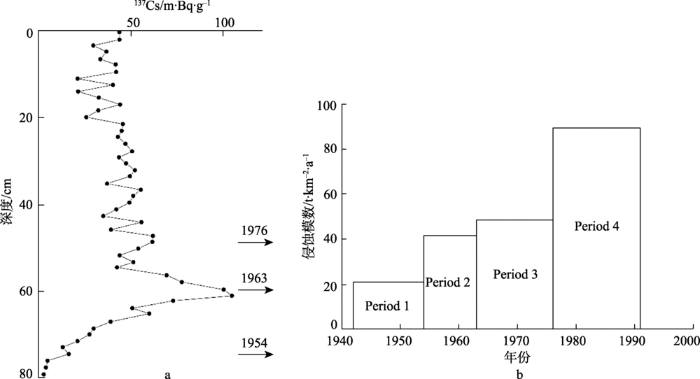
Foster等(1994)在对英国南部德文郡(Devon)的土壤侵蚀研究中,选择了Old Mill水库作为采样地,通过沉积物的137Cs定年,将流域内侵蚀过程分为4个时段并分别计算了平均沉积速率,见图1。研究发现,相比于第二次世界大战时期,研究区内沉积物总量在20世纪90年代增长了4倍多,土壤侵蚀强度明显加剧,通过与土地利用变化进行比较,作者将这一现象归结为战后畜牧业发展所造成的地表植被破坏。此外,在假设大气直接沉降至水库表面的137Cs全部沉积的情况下,水库沉积物中的137Cs仍有2/3是随土壤侵蚀而至,可见被土壤颗粒吸附并随侵蚀过程进入水体的137Cs是水库沉积物中137Cs的主要来源,这也印证了137Cs分析可反映土壤侵蚀的强度变化。
图1 Old Mill水库沉积物137Cs定年结果及沉积序列图(
Fig.1 137Cs dating and sedimentary sequence of Old Mill reservoir (
Owens等(2002)利用137Cs和210Pb对苏格兰Tweed流域河漫滩沉积物进行定年,并根据定年结果计算了不同时段内流域的沉积速率。研究显示,流域内沉积速率自1963年之后有了显著上升。利用降水及土地利用数据与沉积速率进行对比分析,结果表明,降水量变化无法对沉积速率变化作出合理的解释,而土地利用变化与沉积速率之间存在明显的联系,由此可见,在研究区内土地利用变化更能影响土壤侵蚀的强弱。利用同样的方法,陈诗越等(2009)通过137Cs和210Pb定年了山东省东平湖湖泊沉积物柱状岩芯的年代序列,根据沉积速率与记录资料的对比分析,作者认为黄河泛滥与人类活动都是影响东平湖沉积速率变化的重要因素。
虽然利用137Cs和210Pb沉积速率反演土壤侵蚀的强弱程度存在一定的有效性,但相比磁化率等其他指标,其结果反映的仅为几个节点间的平均沉积速率,代表性较弱;因此对于137Cs和210Pb定年而言,其价值更多体现在确定沉积序列年代上,从而为沉积物中其他指标的分析提供一个时间参考。例如,Das等(2008)利用137Cs和210Pb对南非最大的淡水湖Zeekoevlei湖沉积物柱芯进行了定年,用于分析各个时期人类活动对湖泊化学性质的影响。Zan等(2012)同样对中国五大淡水湖之一的巢湖进行了沉积物137Cs和210Pb定年,从而为研究不同时段湖泊化学性质的变化情况提供了时间参考。
综上所述,137Cs和210Pb定年已成为短时间尺度定年中最为常用的方法,即便如此,其定年结果仍然存在一定的不确定性。137Cs和210Pb定年结果的准确性除受样品质量和实验过程中误差的影响,还取决于不同时段内自然环境是否稳定,放射性核素在沉积物中的再迁移以及极端天气事件的发生都会降低实验结果的可靠性(Foster et al, 1994)。相比于210Pb定年,137Cs来源确定且单一,时间节点清晰,更便于定量研究(魏彦昌等, 2006),但涉及的尺度较短;210Pb虽涉及的时间尺度更长,但前提假设十分严格(Appleby et al, 1990)。因此,将210Pb与137Cs结合使用,更能增加定年结果的准确性。
与湖泊(水库)中磁化率较低的自生沉积物相比,随土壤侵蚀进入水体的沉积物通常蕴含着丰富的铁磁性矿物(Dearing, 1999),可被视为湖泊(水库)沉积物中磁性矿物的主要来源(Oldfield, 1991)。值得注意的是,在湖泊(水库)沉积物氧化还原电位较低的情况下,丰富的有机质和大量的还原细菌可使水体内自生矿物含量增加,从而有可能影响磁化率测量结果的准确性(胡守云等, 2001)。但是,由于土壤侵蚀研究的时间尺度较短,自生矿物对于沉积物磁化特征的影响一般较小,因此往往可以忽略不计。总的来说,湖泊(水库)沉积物的矿物磁性主要来自流域内被侵蚀的土壤,其磁性强弱与流域内土壤侵蚀的强度有直接联系。通过研究湖泊(水库)沉积物的磁性特征,可在一定程度上反演不同时期流域内土壤侵蚀过程,探寻影响侵蚀强弱变化的具体因素。
根据近年来国内外学者在环境磁学领域的研究成果,可以总结出一些磁性矿物指标在土壤侵蚀研究中所具有的指示意义。
在对阿尔巴尼亚布特林特地区(Butrint)的研究中,Hounslow等(2004)利用矿物磁性指标反演了该地区450AD-1200AD期间土壤侵蚀的变化情况,并指出低频磁化率(Xlf)可用于表示所有矿物磁性的丰富度,频率磁化率(Xfd%)一般表示超顺磁颗粒(superparamagnetic, SP)的相对含量。超顺磁颗粒多来自表土层,因此Xlf伴随着Xfd%的升高反映了来自表层土壤侵蚀量的增大。Shen等(2008)对英国Crummock Water的研究指出,亚铁磁性矿物多来自土壤表层,使得Xlf、Xfd%、非磁滞剩磁(ARM)和饱和等温剩磁(SIRM)在土壤表层较高,较细SP颗粒和SSD(stable-single domain, SSD)颗粒也多集中于此;而土壤较低层位或母质层中的磁性矿物主要包含反铁磁性矿物,较粗的多畴颗粒(multi-domain, MD)和假单畴颗粒(pseudo-single domain, PSD)所占比例相对较高,硬等温剩磁(HIRM)数值较高。
上述研究从原理上剖析了矿物磁性与土壤侵蚀间的相互联系,为利用湖泊(水库)沉积物磁性特征研究流域土壤侵蚀过程提供了理论依据。总的来看,当侵蚀较弱即主要发生在土壤浅层时,较多的细粒亚铁磁性矿物遭到侵蚀,沉积物中Xlf、Xfd%、ARM、SIRM和相应等温剩磁(IRM20mT)的含量也因此相对较高;当侵蚀加剧致使土壤深层受到侵蚀时,更多的粗颗粒矿物被携带至湖泊(水库),沉积物中IRM-100mT/SIRM会相对升高。据此,通过测量沉积物柱芯中磁化率的变化趋势,便可反演不同时期的土壤侵蚀状况。
Eriksson等(1997)在210Pb定年的基础上,利用磁性参数反演了坦桑尼亚中部Haubi湖流域的土壤侵蚀历史,根据沉积物柱芯中SIRM、ARM等磁性参数的变化趋势,作者判断取样地早期为季节性沼泽,沉积物中富含反铁磁性矿物;自1902年湖泊形成以来,流域内土壤侵蚀加剧,出现了1945-1950年和1955-1990年的侵蚀强烈期,通过对比,作者将土壤侵蚀强度变化的原因归结为受人类活动的影响。利用同样的方法,Thorndycraft等(1998)在对法国东部安纳西湖(Annecy)沉积物的研究中,分析了沉积物4个时段的磁性参数,结果表明,SP和SD(single-domain, SD)颗粒在沉积物中占大多数,在此基础上结合化学分析和孢粉分析,推断出安纳西湖沉积物主要来自土壤表层,且4个时段的侵蚀都与单个的洪水事件有关。
除反演侵蚀过程外,为更好地克服放射性核素测量成本高、耗时长等问题,Ayoubi等(2012)还尝试利用沉积物样品中的矿物磁性参数与137Cs含量进行相关性分析,试图为137Cs寻找替代指标。结果表明,研究区样品中低频磁化率Xlf与137Cs的非线性拟合结果优于线性拟合,两者间存在明显的正相关,R2=0.45;在此基础上进一步利用Xlf与可提取的钾元素K对137Cs进行多元线性拟合,R2=0.61,相关性更加明显,从而肯定了利用矿物磁性作为137Cs替代指标的可能性。
利用矿物磁性反演流域土壤侵蚀过程的研究,通常忽略湖泊(水库)中自生矿物的影响,而认为湖泊(水库)沉积物中的矿物磁性主要来自流域内被侵蚀的土壤。需要注意的是,在一些特殊环境下,沉积物中自生矿物的存在会对研究结果造成极大的影响。在对美国宾夕法尼亚州伊利湖的研究中,Kim等(2005)便发现湖泊沉积物中过去几百年间的矿物磁性主要来自细菌磁铁矿,大量的自生矿物掩盖了被土壤侵蚀带入湖泊的磁性信息,使得针对侵蚀过程的分析无法进行。由此可见,利用沉积物磁性参数研究土壤侵蚀仍然存在其不确定性,需要在今后的研究中加以改善。但不可否认的是,在大多数情况下,针对湖泊(水库)沉积物的磁性测量可提供有关沉积物来源和沉积过程的重要信息,而相比单独利用磁性参数进行分析,将沉积物磁性参数作为土壤侵蚀多指标研究方法中的关键一环,更能提高研究结果的准确性(Oldfield, 2013; Oldfield et al, 2010)。
沉积物粒度是衡量沉积环境的一种代用指标,在研究百年尺度土壤侵蚀的过程中,湖泊(水库)水位变化很小,降雨量的变化将成为影响沉积物粒度的主要因素。降雨量大的年份,地表径流发育,土壤侵蚀较强,使得更多的粗粒物质被搬运入水体;降雨量小的年份,地表径流较弱,沉积于水体中的物质粒度较小(陈敬安等, 2003; 吴霜等, 2017)。除受自然因素影响外,人为因素对粒度的作用也不可忽视,植被砍伐和过度放牧等行为都会引起侵蚀加剧从而使沉积物粒度变大。因此,在利用湖泊(水库)沉积物反演土壤侵蚀的过程中需要对粒度的变化趋势加以考虑。
以上观点在Gao等(2015)对中国重庆龙溪流域的研究中得到证实。在对长寿水库沉积物的分析过程中,通过将不同时间段降雨侵蚀力强度和沉积物颗粒大小进行对比,作者确定了降雨强度是决定沉积物颗粒大小的重要因素之一,极端降雨事件会使深层砂砾受到侵蚀从而降低黏粒土壤在沉积物中的比例(Tanaka et al, 2014);但随着人类改变自然能力的增强,土地利用方式的转变对沉积物粒度的影响显得更加突出,1982-1988年家庭联产责任承包制的实施和1990年以来生态保护工程的启动,都深刻地影响着研究流域相应时段的土壤侵蚀强度,并在沉积物粒度序列中得到体现。
湖泊(水库)沉积物粒度除可反演研究区的土壤侵蚀过程外,其与矿物磁性之间的相关关系一直以来也是国内外科学家研究的重点。Dearing等(1981)、Dearing等(1986)在对威尔士Llyn Peris湖流域侵蚀过程的研究中指出,当搬运入湖的磁性矿物种类一定时,磁化率波动的主要因素是侵蚀产物颗粒的粒度发生了变化,并总结出湖泊(水库)沉积物粒度与磁性参数之间存在相关关系。
Foster等(1998)在对英国德文郡南部Old Mill水库流域的研究中,以63 μm为界分析了粒度与沉积物磁性之间的关系,指出:Xlf、ARM不论沉积物粒度变粗变细,数值都会增加;Xfd和Xfd%随着粒度变细逐渐增加,HIRM和IRM800mT随着颗粒越粗数值越大,并将颗粒粒度与磁性参数进行拟合,取得了不错的效果。Booth等(2005)也指出,利用矿物磁性作为沉积物粒度的代用指标具有一定的可行性。
基于粒度与磁化率之间的关系,在研究土壤侵蚀的过程中通常将两者结合进行分析,以提升结果的可信度。Wang等(2008)和Wang等(2011)在对贵州石板桥水库和小河水库的研究中,结合磁化率、粒度等参数,反演了流域内近50年来的土壤侵蚀状况。
当然,通过湖泊(水库)沉积物粒度分析研究土壤侵蚀过程的方法并不仅限于此。张晴华等(2014)将沉积物粒度与植物孢粉信息相结合,对广东黄洞水库沉积物所反映的近50年土壤侵蚀信息进行了研究,结果表明:在孢粉浓度较低的时期,植被覆盖度较差,此时沉积物粒度的变化通常与降雨事件相对应;但在孢粉浓度较高的时期,植被覆盖度较好,沉积物粒度变化则由人类活动所决定。此外,王小雷等(2010)在对云南抚仙湖近代环境变化的研究中,通过选取平均粒度、分选系数、偏度等粒度指标,结合137Cs和210Pb的定年结果,将抚仙湖环境演变过程大致划分为4个阶段,以此确定不同阶段流域内的土壤侵蚀状况,并结合土地利用信息,证实了相应历史时期强烈的人类活动(围湖造田、砍伐森林等)是影响抚仙湖沉积环境的一个重要因素。
虽然利用沉积物粒度进行土壤侵蚀研究具有一定的有效性,但以上分析均属于定性分析,且受泥沙输移过程和沉积环境等外部因素的影响,通过沉积物粒度分析反演土壤侵蚀过程误差较大,通常需与其他参数结合使用,以提升实验结果的准确性。在今后的研究中,寻找更为有效的粒度指标以降低实验误差,将沉积物粒度运用于土壤侵蚀模型以推动定量化进程,将是该研究领域主要的发展 方向。
湖泊沉积物地球化学指标受控于有机质的来源、运移路径、沉积过程以及保存能力等,反映的信息丰富,可用于短时间尺度流域土壤侵蚀过程的重建,其中常用的有机地球化学指标包括碳—氮比值(C/N)和全有机碳含量(TOC)。
湖相沉积物中的有机质有2种来源,分别为外源的陆生植物和内源的水生生物(Meyers et al,1999)。水生生物降解产物含有较多的蛋白质,C/N一般较低;而陆源植物富含木质素且蛋白质较少,C/N通常大于20。可见,当流域内土壤侵蚀增强,进入水体的陆生植物残体增多,沉积物中的C/N便会相应上升;当流域内土壤侵蚀强度减弱,进入水体的陆生植物残体减少,则沉积物中的C/N便会降低。
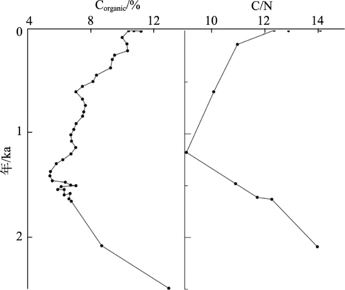
TOC可反映湖泊及流域的初级生产力状况,即沉积物中有机质的含量,与C/N类似。当侵蚀加剧,进入水体的陆生植物残体增多,TOC上升;当侵蚀减弱,进入水体的陆生植物残体减少,TOC降低。可以看出,湖泊(水库)沉积物中TOC与C/N的变化趋势通常较为一致(图2)。
图2 湖泊沉积物中TOC浓度和C/N变化图(
Fig.2 Variation of TOC concentration and C/N in lake sediments(
Olsson等(1997)在对瑞典南部湖泊的研究中指出,该地区C/N的升高与土壤侵蚀的加剧紧密相关,这一观点在Kaushal等(1999)的研究中也有体现。18世纪末美国马萨诸塞州大规模的森林砍伐正好同Pleasant湖沉积物中C/N的升高相同步,显然森林的砍伐一方面会加剧土壤侵蚀过程,另一方面会将大量的木屑颗粒带入湖中,从而改变湖泊沉积物的化学性质。Routh等(2004)对瑞典Brunnsviken湖沉积物的分析还表明C/N和TOC同大规模城市建设之间的联系,城市的发展不仅改变当地的土壤侵蚀状况,随之而来的人为污染也将对湖泊沉积的理化性质产生十分重要的影响。
需要注意的是,对于TOC和C/N的分析一定要与实际情况相结合,Fisher等(2003)在英国Gormire湖的研究就发现,高强度的土地利用和森林砍伐对应着C/N的大幅降低,而这一异常状况的出现可能也是土壤侵蚀增强的结果,即伴随着土壤侵蚀的加剧,更多的营养物质被带入湖泊,水生植被和内源有机质迅速增长,从而使得C/N逐渐降低;同样,TOC的降低也不总是指示侵蚀的减弱,更多的成矿物质随土壤侵蚀的加剧不断流入湖泊将在一定程度上稀释有机质的浓度,造成TOC的降低(Enters et al, 2006)。为了避免上述影响,Meyers(2003)尝试使用有机质沉积速率MARs(mass accumulation rates)研究沉积环境的变化,并取得了不错的效果。
除TOC和C/N外,总氮(TN)、碳—硫比(C:S)、有机稳定同位素δ13Corg等也都是土壤侵蚀研究领域中常用的地球化学指标,在发展并完善这些指标的同时,为更好地表征流域的土壤侵蚀过程,学者们提出和使用了一些新的地球化学指标,并取得了不错的效果(张灿等, 2015)。Boyle等(2011)就曾利用湖泊沉积物中Ti的浓度作为土壤侵蚀强度变化的指标,并采用Ti/K指示侵蚀来源的变化情况;当底层土壤侵蚀越强烈Ti/K越大,反之亦然。此外,利用脂质分子判断沉积物中有机质来源也十分有效,基于其自身特性,相比TOC、C/N等传统的有机质指标,沉积物中的脂质分子对于流域的环境变化显得更为敏感(Lammers et al, 2013)。一般认为,短链脂质分子源于内源水生生物,而长链脂质分子则来自外源陆生生物(O'Beirne et al, 2015),两者的比率可在一定程度上反映内源和外源有机质对湖泊(水库)沉积物中有机质的贡献程度,从而反演土壤侵蚀状况。结合脂质分子和化学元素指标,通过沉积物的时间序列分析,Zhang等(2016)成功地反演了泸沽湖周边环境在过去200年间的变化过程,并强调了人类活动在其中扮演的主导作用。
基于湖泊(水库)沉积物分析,除反映气候—环境变化和人类活动对土壤侵蚀强弱的影响外,还可结合地表信息识别不同时期沉积物的来源。通过对比沉积物与土壤的特定理化性质,进而寻找沉积物来源的方法被统称为“指纹示踪技术”,该方法于20世纪70年代兴起,并在世界各地得到了广泛的使用。
将磁性参数作为“示踪因子”进行指纹示踪是诸多示踪方法中发展较早的一类(Stott, 1986; Yu et al, 1989)。David等(1998)在对英国Groby湖的研究中明确说明了:流域内表土层高Xlf和Xfd,而底土层Xlf和Xfd较低,由此可相对容易地判断沉积物主要源自流域表层土壤还是底层土壤。Foster(1998)的研究结果表明,表土层与底土层相比在Xlf、Xfd、IRM(0.8T-0.1T)以及IRM(-0.1T)/IRM(0.8T)上数值较高,在HIRM上较低;而在Xfd%和ARM上两者差距不大。此前,Dearing等(1986)还提出了利用SIRM/Xlf分辨表土和底土对沉积物的相对贡献程度方法。
除反演沉积物的相对来源外,利用磁性参数还可追寻具体的沉积物来源。Oldfield(1979)等以Xlf、SIRM和Corecivity of IRM为指标,对比了湖泊悬浮沉积物与不同土地利用条件下土壤样品的差异,结果表明,研究区内湖泊悬浮沉积物磁性参数介于林地表层土壤和母质之间,与耕地表层土壤最为相似,这说明在当时的环境条件下,耕地是土壤侵蚀最强烈的地区。
随着研究的逐渐深入,越来越多的“示踪因子”被引入指纹示踪技术,除最初的矿物地球化学指标和磁性参数外,沉积物颜色、植物孢粉种类、同位素特征特别是放射性核素特征都被尝试用于进行沉积物示踪(Walling, 2005)。在英国德文郡的研究中,Foster(1996)首先利用矿物磁性确定了土壤表层为主要侵蚀源,在此基础上通过对比河漫滩表层沉积物、牧场表层1 cm土壤和耕地表层1 cm土壤的137Cs浓度,证明牧场是研究流域自1970s以来主要的侵蚀源地。此外,在对南非Karoo Uplands 2个小流域的研究中,Foster等(2007)还验证了利用210Pb示踪沉积物来源的有效性。
20世纪90年代,有关指纹示踪技术的研究迎来了跨越性的发展,定量混合模型与复合指纹示踪技术的结合使得定量评估不同沉积物来源占比成为可能(Walling, 2005)。复合指纹示踪技术通过选取多个差异性最大的“示踪因子”,结合多变量线性混合模型便可有效地获取不同沉积物来源的相对比例。郭进等(2014)以三峡库区一个封闭式农业单元小流域为研究区,对复合指纹示踪技术定量辨析塘库沉积泥沙来源进行了尝试。研究过程中首先定性地划分了旱地、水田、林草地3种泥沙来源,通过指纹因子非参数检验和多元判别分析,将土壤全碳、放射性核素137Cs、226Ra、碱金属K及重金属Zn等参数共同组成了最优复合指纹因子组,结合Walling模型,定量揭示了3种来源相对淤沙贡献分别为:旱地约84%,林草地约2%,水田约14%,有效地验证了复合指纹示踪技术在辨析小流域泥沙来源中所发挥的显著作用。在对法国Louroux农业流域的研究中,Le等(2015)以锶同位素比值(87Sr/86Sr)为“示踪因子”,成功地确定了研究流域沉积物的2个主要来源——悬浮颗粒物、碳酸岩,并在此基础上利用质量平衡方程,给出了1955-2013年间4个不同时期2种沉积物来源的相对比例。
复合指纹示踪技术成功地将定量分析引入沉积物示踪研究中,使得对沉积物来源的识别不再限于土壤表层和底层的辨析以及单一潜在源地的定性指示,成为了进行土壤侵蚀研究的重要手段。但是复合指纹示踪技术的运用依然存在一定的局限性,对流域内潜在泥沙来源的定性划分是否准确,“示踪因子”的选择是否合适,以及其在侵蚀运输过程中是否会发生变化,这些问题都将影响最终的实验结果(Pulley et al, 2015; Sadeghi et al, 2014),为得到更加准确的土壤侵蚀信息,针对复合指纹示踪技术,有必要在今后的研究中对其进行更加深入的改进和优化(唐强等, 2013)。
根据上述3个方面的讨论和总结,可以肯定的是利用湖泊(水库)沉积物研究土壤侵蚀具有其特有的优势。关于土壤/水库沉积物的研究一方面可以复原曾经发生的土壤侵蚀过程,弥补观测资料的不足;另一方面还可对沉积物来源进行示踪,探寻侵蚀的发生源地。以上2点对土壤侵蚀研究具有重要的意义,表明利用湖泊(水库)沉积物研究土壤侵蚀具有很大的发展潜力和应用价值。但不可否认的是,基于湖泊(水库)的土壤侵蚀研究同样也存在着以下一些缺陷:首先,研究中对于突发性灾变事件的识别尚无准确的方法,这在土壤侵蚀研究的各个领域都有所体现;此外,无论是定年、反演侵蚀过程还是示踪沉积物来源,从研究区的选取、样品的采集到实验处理和数据分析,每一步都存在不确定的因素,比如研究区划定时遵从的湖泊、流域面积比取多少合适,采样点应选择在湖泊中什么位置,放射性核素是否存在沉积滞后或沉积后再迁移等,为确保实验结果的准确性,研究者必须深入了解研究过程中包含的理论问题,选取最优方式,以减少可能出现的误差。
随着土壤侵蚀研究的日趋成熟,研究方法从定性到定量的转变也随之发生,模型的使用将越加广泛,湖泊(水库)沉积物数据与模型的结合将是土壤侵蚀研究中的重要一环。对于土壤侵蚀速率模型和沉积物示踪模型来说,有关湖泊(水库)沉积物的数据已是模型中十分重要的组成部分,可以说,这一结合有效地拓宽了土壤侵蚀定量研究的思路和方法。值得注意的是,基于现阶段的研究成果,尽管未来的气候变化很有可能会加剧土壤侵蚀程度,但通过模型可以证明,相比于气候变化,土地利用变化对土壤侵蚀的影响将会更加突出,因此人类影响因子也将是未来模型研究领域中不可忽视的组成部分(Boardman, 2006)。
未来很长时期内,土壤侵蚀都将是人类面临的重大环境问题之一,基于湖泊(水库)沉积物的土壤侵蚀研究将为开展水土保持工作提供有效的支持。此外,将湖泊(水库)沉积物信息与3S技术、地球化学方法等多学科领域相交叉,发展并完善针对不同环境类型、不同时空尺度的研究手段,对土壤侵蚀从发生机制、沉积物运移方式到生态响应和人为治理的多个角度开展深入研究,将极大地推动土壤侵蚀研究领域的进步和发展,从而帮助人类更有效地应对未来气候环境下愈加严峻的挑战。
The authors have declared that no competing interests exist.
| [1] |
不同时间尺度下的湖泊沉积物环境记录: 以沉积物粒度为例 [J].Environmental records of lacustrine sediments in different time scales: Sediment grain size as an example [J]. |
| [2] |
东平湖沉积物210Pb、137Cs垂直分布及年代学意义 [J].Vertical distribution and chronological implication of 210Pb and 137Cs in sediments of Dongping Lake, Shandong Province [J]. |
| [3] |
复合指纹识别技术定量示踪流域泥沙来源 [J].https://doi.org/10.3969/j.issn.1002-6819.2014.02.013 URL [本文引用: 2] 摘要
土壤侵蚀导致水土资源及土地生产力的破坏和损失,泥沙淤积危害及其引发的一系列水环境效应已成为当前及以后一段时期内研究的热点和重点。开展流域(河流)泥沙来源研究,查明入塘、河、库泥沙通量,定量识别泥沙来源具有重要现实指导意义。选取了一个由山坪塘控制出口的封闭式农业单元小流域(10.7hm^2),开展复合指纹识别技术定量辨析塘库沉积泥沙来源新尝试。据流域现状,定性划分了3种泥沙来源,即旱地、水田、林草地,并分别于塘库中部采取A、B、C三柱表层沉积泥沙;结合复合指纹识别技术定量解析了塘库表层沉积泥沙来源。研究表明,塘库沉积泥沙各来源相对输沙贡献分别为旱地84%、水田14%、林草地2%,复合指纹识别技术能较好地辨析小流域泥沙来源。
Quantifying catchment scale sediment source using composite fingerprinting technique [J].https://doi.org/10.3969/j.issn.1002-6819.2014.02.013 URL [本文引用: 2] 摘要
土壤侵蚀导致水土资源及土地生产力的破坏和损失,泥沙淤积危害及其引发的一系列水环境效应已成为当前及以后一段时期内研究的热点和重点。开展流域(河流)泥沙来源研究,查明入塘、河、库泥沙通量,定量识别泥沙来源具有重要现实指导意义。选取了一个由山坪塘控制出口的封闭式农业单元小流域(10.7hm^2),开展复合指纹识别技术定量辨析塘库沉积泥沙来源新尝试。据流域现状,定性划分了3种泥沙来源,即旱地、水田、林草地,并分别于塘库中部采取A、B、C三柱表层沉积泥沙;结合复合指纹识别技术定量解析了塘库表层沉积泥沙来源。研究表明,塘库沉积泥沙各来源相对输沙贡献分别为旱地84%、水田14%、林草地2%,复合指纹识别技术能较好地辨析小流域泥沙来源。
|
| [4] |
湖泊沉积物磁学性质的环境意义 [J].Environmental magnetic study of lacustrine sediments [J]. |
| [5] |
贵州省西南部麦岗水库沉积物的137Cs和210Pb测年与沉积速率研究 [J].
对贵州省西南部麦岗水库沉积物柱芯MG4-2,采用210Pb和137Cs法进行了测年与现代沉积速率研究。结果表明,该柱芯中存在这3个明显的137Cs蓄积峰,对应1964,1975,1986年3个计年时标。运用210Pb的恒定补给速率(CRS)模式计算得到的年代,总体上与137Cs法的结果吻合较好,但存在一定的偏差,特别是与1964年的计年时标的偏差较大,这可能是因为沉积物柱芯受到了一些人为扰动所致。两种核素测定的平均沉积速率在数值上有一定的偏差,但都反映了麦岗水库沉积物近几十年以来经历了从慢到快再到慢的沉积过程,初步推测,沉积速率的这种变化与人类活动有一定的关系。两种计年方法结合,相互印证,使计年和沉积速率的研究更为准确。
137Cs and 210Pb dating and inference of sedimentation rate for Maigang Reservoir in southwest Guizhou Province [J].
对贵州省西南部麦岗水库沉积物柱芯MG4-2,采用210Pb和137Cs法进行了测年与现代沉积速率研究。结果表明,该柱芯中存在这3个明显的137Cs蓄积峰,对应1964,1975,1986年3个计年时标。运用210Pb的恒定补给速率(CRS)模式计算得到的年代,总体上与137Cs法的结果吻合较好,但存在一定的偏差,特别是与1964年的计年时标的偏差较大,这可能是因为沉积物柱芯受到了一些人为扰动所致。两种核素测定的平均沉积速率在数值上有一定的偏差,但都反映了麦岗水库沉积物近几十年以来经历了从慢到快再到慢的沉积过程,初步推测,沉积速率的这种变化与人类活动有一定的关系。两种计年方法结合,相互印证,使计年和沉积速率的研究更为准确。
|
| [6] |
基于湖泊(水库)沉积物分析的土壤侵蚀研究 [J].https://doi.org/10.3969/j.issn.1000-288X.2007.03.008 URL [本文引用: 1] 摘要
土壤侵蚀作为全球性的环境问题之一,受自然和人为因素的共同影响。而湖泊(水库)沉积物作为流域物质迁移的“汇”,可以连续、高分辨率地记录流域土壤侵蚀的信息。通过湖泊沉积指标的研究,可以反演流域土壤侵蚀过程、演化规律。与流域人类活动、气候变化等自然因素综合分析,可对流域土壤侵蚀发生机制等做出科学论断,为目前水土流失治理等提供参考依据。介绍了基于湖泊(水库)沉积物的放射性同位素示踪研究、矿物与磁性分析、粒度分析、孢粉、元素地球化学分析方法应用于土壤侵蚀的研究进展,并对其应用前景做了瞻望。
Soil erosion investigations based on analyses of sediment in lakes and reservoirs [J].https://doi.org/10.3969/j.issn.1000-288X.2007.03.008 URL [本文引用: 1] 摘要
土壤侵蚀作为全球性的环境问题之一,受自然和人为因素的共同影响。而湖泊(水库)沉积物作为流域物质迁移的“汇”,可以连续、高分辨率地记录流域土壤侵蚀的信息。通过湖泊沉积指标的研究,可以反演流域土壤侵蚀过程、演化规律。与流域人类活动、气候变化等自然因素综合分析,可对流域土壤侵蚀发生机制等做出科学论断,为目前水土流失治理等提供参考依据。介绍了基于湖泊(水库)沉积物的放射性同位素示踪研究、矿物与磁性分析、粒度分析、孢粉、元素地球化学分析方法应用于土壤侵蚀的研究进展,并对其应用前景做了瞻望。
|
| [7] |
泥沙来源“指纹”示踪技术研究综述 [J].https://doi.org/10.3969/j.issn.1672-3007.2013.03.019 URL [本文引用: 1] 摘要
泥沙来源"指纹"示踪技术是综合研究流域土壤侵蚀和泥沙输移的新方法。泥沙来源"指纹"示踪技术基于流域侵蚀产沙过程划分潜在物源类型,根据物源特性筛选具有诊断能力的"指纹"性质,通过定量转换模型建立流域出口泥沙与内部潜在物源间的"指纹"联系,定量描述各潜在物源对流域出口产沙的相对贡献;结合悬移质或沉积泥沙通量监测,定量分析各潜在物源对流域产沙的绝对贡献量及流域侵蚀产沙时、空变化特征。通过综述泥沙来源"指纹"示踪技术的理论基础及实施框架,流域尺度潜在物源类型,泥沙"指纹"因子类别、分布特点及诊断能力,泥沙来源复合"指纹"示踪技术的研究进展,指出泥沙来源"指纹"示踪技术的局限性,并对泥沙来源"指纹"示踪技术进行展望。
A review of studies on catchment sediment sources discrimination with fingerprinting techniques [J].https://doi.org/10.3969/j.issn.1672-3007.2013.03.019 URL [本文引用: 1] 摘要
泥沙来源"指纹"示踪技术是综合研究流域土壤侵蚀和泥沙输移的新方法。泥沙来源"指纹"示踪技术基于流域侵蚀产沙过程划分潜在物源类型,根据物源特性筛选具有诊断能力的"指纹"性质,通过定量转换模型建立流域出口泥沙与内部潜在物源间的"指纹"联系,定量描述各潜在物源对流域出口产沙的相对贡献;结合悬移质或沉积泥沙通量监测,定量分析各潜在物源对流域产沙的绝对贡献量及流域侵蚀产沙时、空变化特征。通过综述泥沙来源"指纹"示踪技术的理论基础及实施框架,流域尺度潜在物源类型,泥沙"指纹"因子类别、分布特点及诊断能力,泥沙来源复合"指纹"示踪技术的研究进展,指出泥沙来源"指纹"示踪技术的局限性,并对泥沙来源"指纹"示踪技术进行展望。
|
| [8] |
云南抚仙湖近现代环境变化的沉积物粒度记录 [J].
通过对云南抚仙湖沉积物柱芯样品的放射性核素210Pb和137Cs的测试,确定了过去129年的湖泊连续沉积序列.利用210PbCRS计年模式,计算出每个样品深度所对应的年代,与137Cs时标计年法比较存在一定的偏差,分析了两种计年方法存在差异性的原因.根据抚仙湖的湖区特点,对沉积物的粒度特征进行了分析.抚仙湖柱芯的粘土(<4μm)、细粉砂(4~16μm)和粗粉砂(16~63μm)含量分别占约36%,44%和18%.粒度参数根据矩值法求得,平均粒径(φ值)为6.48~7.92,分选系数SO为1.27~1.42,偏度SKD分布范围在-0.18~0.04之间.将整个柱芯的计年结果与粒度特征相结合,自1878年以来,抚仙湖的环境演化大致可以划分为4个阶段:自然演化阶段,人为扰动阶段,人为改造阶段,后期治理阶段.人类活动在特定的历史时期会对湖泊环境变化产生较大的影响.
Recent environmental change inferred from grain-size records in Fuxian Lake, Yunnan Province [J].
通过对云南抚仙湖沉积物柱芯样品的放射性核素210Pb和137Cs的测试,确定了过去129年的湖泊连续沉积序列.利用210PbCRS计年模式,计算出每个样品深度所对应的年代,与137Cs时标计年法比较存在一定的偏差,分析了两种计年方法存在差异性的原因.根据抚仙湖的湖区特点,对沉积物的粒度特征进行了分析.抚仙湖柱芯的粘土(<4μm)、细粉砂(4~16μm)和粗粉砂(16~63μm)含量分别占约36%,44%和18%.粒度参数根据矩值法求得,平均粒径(φ值)为6.48~7.92,分选系数SO为1.27~1.42,偏度SKD分布范围在-0.18~0.04之间.将整个柱芯的计年结果与粒度特征相结合,自1878年以来,抚仙湖的环境演化大致可以划分为4个阶段:自然演化阶段,人为扰动阶段,人为改造阶段,后期治理阶段.人类活动在特定的历史时期会对湖泊环境变化产生较大的影响.
|
| [9] |
放射性核素137Cs在土壤侵蚀研究中的应用 [J].Application of radioactive fallout cesium-137 for soil erosion measurement [J]. |
| [10] |
赣北黄茅潭湖泊沉积记录的240年以来古洪水事件 [J].https://doi.org/10.18306/dlkxjz.2017.11.010 URL [本文引用: 1] 摘要
古洪水研究是近几十年来全球变化研究的一个热点,同时也是难点.本文利用赣北黄茅潭的湖泊沉积,建立了小冰期以来全球变暖背景下的区域洪水记录.采用210pb和mCs方法厘定了地层年代,基于粒度与元素地球化学指标的对比分析,揭示了器测记录(1950年)以来指标记录的特点与区域日降水超过50 mm天数的关系,认为黄茅潭HMT-01孔粒度(包括粗粉砂+砂/粘土比值、平均粒径)和Zr/Rb、Ti/Rb、Zr/Fe比值可作为洪水指标记录,共识别出1950-2010年期间记载的13次洪水事件中的11次.基于这些指标记录及指标特点,共识别1769-1950年间由历史文献记录的31次洪水事件中的23次,识别率达74.2%.研究表明:①湖泊沉积中Zr/Rb、Ti/Rb、Zr/Fe比值和粒度参数(平均粒径、粗粉砂+砂/粘土)作为洪水指标,对洪水事件沉积有较好的指示作用,且Zr/Rb比值对洪水事件的检出率较高;②黄茅潭流域洪水发生频率暖期高于冷期;③年代际尺度上,1820s-1840s,1860s-1870s为19世纪冷期黄茅潭洪水高频期,这两个阶段对应东亚夏季风偏强,长江中下游地区降雨较多;20世纪赣北黄茅潭洪水基本随1920s-1940s,1980s-1990s两个变暖阶段而高频出现,与长江中下游大洪水演变特点基本一致.研究结果为利用湖泊沉积记录反演过去的洪水变化,延长洪水序列、认识洪水规律提供了一定的科学依据.
A 240-year sedimentary record of paleoflood events from the Huangmaotan Lake, northern Jiangxi Province [J].https://doi.org/10.18306/dlkxjz.2017.11.010 URL [本文引用: 1] 摘要
古洪水研究是近几十年来全球变化研究的一个热点,同时也是难点.本文利用赣北黄茅潭的湖泊沉积,建立了小冰期以来全球变暖背景下的区域洪水记录.采用210pb和mCs方法厘定了地层年代,基于粒度与元素地球化学指标的对比分析,揭示了器测记录(1950年)以来指标记录的特点与区域日降水超过50 mm天数的关系,认为黄茅潭HMT-01孔粒度(包括粗粉砂+砂/粘土比值、平均粒径)和Zr/Rb、Ti/Rb、Zr/Fe比值可作为洪水指标记录,共识别出1950-2010年期间记载的13次洪水事件中的11次.基于这些指标记录及指标特点,共识别1769-1950年间由历史文献记录的31次洪水事件中的23次,识别率达74.2%.研究表明:①湖泊沉积中Zr/Rb、Ti/Rb、Zr/Fe比值和粒度参数(平均粒径、粗粉砂+砂/粘土)作为洪水指标,对洪水事件沉积有较好的指示作用,且Zr/Rb比值对洪水事件的检出率较高;②黄茅潭流域洪水发生频率暖期高于冷期;③年代际尺度上,1820s-1840s,1860s-1870s为19世纪冷期黄茅潭洪水高频期,这两个阶段对应东亚夏季风偏强,长江中下游地区降雨较多;20世纪赣北黄茅潭洪水基本随1920s-1940s,1980s-1990s两个变暖阶段而高频出现,与长江中下游大洪水演变特点基本一致.研究结果为利用湖泊沉积记录反演过去的洪水变化,延长洪水序列、认识洪水规律提供了一定的科学依据.
|
| [11] |
湖泊沉积记录的古洪水事件识别及与气候关系 [J].https://doi.org/10.18306/dlkxjz.2015.07.011 URL [本文引用: 1] 摘要
作为洪水灾害研究的延伸学科——古洪水研究,其所取得的大量研究成果基本都是基于河流古洪水水文学的研究。然而随着河流古洪水水文学科的发展,研究材料和方法的缺陷越来越凸显,而作为气候与环境变化信息重要收集器的湖泊沉积物在古洪水水文学上的研究可以弥补上述不足。本文重点综述了湖泊沉积物识别古洪水的方法以及古洪水与环境的耦合机制。主要分为两部分:其一,总结了湖泊洪水识别的4种方法,即湖泊沉积物岩性和粒径、地球化学指标、数学统计分析方法以及洪水与块体运动的甄别;其二,从成因上探讨了古洪水与大陆尺度大气环流变化、区域气候波动的遥相关性。最后,探讨了洪水事件和气候变化的具体物理机制,并对湖泊洪水与同区域河流洪水进行对比研究以及国内湖泊尤其高山地区湖泊洪水领域的研究等方面进行了展望。
Identification of palaeoflood events by lacustrine archives and their links to climatic conditions [J].https://doi.org/10.18306/dlkxjz.2015.07.011 URL [本文引用: 1] 摘要
作为洪水灾害研究的延伸学科——古洪水研究,其所取得的大量研究成果基本都是基于河流古洪水水文学的研究。然而随着河流古洪水水文学科的发展,研究材料和方法的缺陷越来越凸显,而作为气候与环境变化信息重要收集器的湖泊沉积物在古洪水水文学上的研究可以弥补上述不足。本文重点综述了湖泊沉积物识别古洪水的方法以及古洪水与环境的耦合机制。主要分为两部分:其一,总结了湖泊洪水识别的4种方法,即湖泊沉积物岩性和粒径、地球化学指标、数学统计分析方法以及洪水与块体运动的甄别;其二,从成因上探讨了古洪水与大陆尺度大气环流变化、区域气候波动的遥相关性。最后,探讨了洪水事件和气候变化的具体物理机制,并对湖泊洪水与同区域河流洪水进行对比研究以及国内湖泊尤其高山地区湖泊洪水领域的研究等方面进行了展望。
|
| [12] |
广东惠州黄洞水库沉积物特征及其反映的近50年土壤侵蚀意义 [J].https://doi.org/10.11821/dlyj201404005 URL [本文引用: 1] 摘要
在广东省东南部惠州市的黄洞水库中取得沉积物柱芯,对其样品做了210Pb和137Cs比活度分析、粒度分析和孢粉及炭屑分析,并收集了这一水库邻近气象站的降水数据,计算了1960年以来的年降水量、夏季(6-9月)降水量和24小时暴雨量。利用上述210Pb和137Cs比活度分析结果建立了沉积物剖面的年代框架,结合孢粉浓度、炭屑浓度与降水量计算结果,对沉积剖面的粒度变化做出了解译,并初步推测1960-2009年间水库所在流域的土壤侵蚀变化情况及其原因。研究表明,在该亚热带丘陵地区植被覆盖度较高的自然条件下,侵蚀作用对降水量波动和植被(尤其是乔木、灌木等木本植物)覆盖度变化的响应十分灵敏,水库沉积物的粒度变化在一定程度上可以反映流域内土壤侵蚀相对强度的变化。
Characteristics of sediment from Huangdong Reservoir in Huizhou, Guangdong Province and their implications on soil erosion during the past 50 years [J].https://doi.org/10.11821/dlyj201404005 URL [本文引用: 1] 摘要
在广东省东南部惠州市的黄洞水库中取得沉积物柱芯,对其样品做了210Pb和137Cs比活度分析、粒度分析和孢粉及炭屑分析,并收集了这一水库邻近气象站的降水数据,计算了1960年以来的年降水量、夏季(6-9月)降水量和24小时暴雨量。利用上述210Pb和137Cs比活度分析结果建立了沉积物剖面的年代框架,结合孢粉浓度、炭屑浓度与降水量计算结果,对沉积剖面的粒度变化做出了解译,并初步推测1960-2009年间水库所在流域的土壤侵蚀变化情况及其原因。研究表明,在该亚热带丘陵地区植被覆盖度较高的自然条件下,侵蚀作用对降水量波动和植被(尤其是乔木、灌木等木本植物)覆盖度变化的响应十分灵敏,水库沉积物的粒度变化在一定程度上可以反映流域内土壤侵蚀相对强度的变化。
|
| [13] |
用137Cs计年法确定湖泊沉积物沉积速率研究进展 [J].https://doi.org/10.3321/j.issn:1001-8166.2005.06.011 URL [本文引用: 1] 摘要
137Cs计年法利用137Cs固有的理化和沉降特性,在湖泊沉积物的137Cs垂直分布与大气137Cs沉降间确立对应关系,找出有异常137Cs含量的沉积层作为时标,但需注意137Cs从水体表面至湖底的时间和粘粒含量对各层137Cs含量的影响,并用其它方法校验时标的可靠性。再求取不同时标层间的年均沉积厚度,或因克服了压实效应而更能反映真实沉积速率的年均沉积通量,且结合GIS等手段进一步估算湖泊各区域的沉积总量;还可延伸研究湖泊内源污染负荷及相关环境演变和湖泊演化。但是,沉积柱样的分割厚度取多少才能既满足计年精度要求又不使工作量过大,137Cs的大气沉降时间与进入沉积物时间还与泥沙的陆地迁移时间有关,沉积物中究竟是否发生137Cs下渗及其机理等都还是此法应用中有待解决的问题。
An overview on the evaluation of sediment accumulation rate of lake by 137Cs dating [J].https://doi.org/10.3321/j.issn:1001-8166.2005.06.011 URL [本文引用: 1] 摘要
137Cs计年法利用137Cs固有的理化和沉降特性,在湖泊沉积物的137Cs垂直分布与大气137Cs沉降间确立对应关系,找出有异常137Cs含量的沉积层作为时标,但需注意137Cs从水体表面至湖底的时间和粘粒含量对各层137Cs含量的影响,并用其它方法校验时标的可靠性。再求取不同时标层间的年均沉积厚度,或因克服了压实效应而更能反映真实沉积速率的年均沉积通量,且结合GIS等手段进一步估算湖泊各区域的沉积总量;还可延伸研究湖泊内源污染负荷及相关环境演变和湖泊演化。但是,沉积柱样的分割厚度取多少才能既满足计年精度要求又不使工作量过大,137Cs的大气沉降时间与进入沉积物时间还与泥沙的陆地迁移时间有关,沉积物中究竟是否发生137Cs下渗及其机理等都还是此法应用中有待解决的问题。
|
| [14] |
The calculation of 210Pb dates assuming a constant rate of supply of unsupported 210Pb to the sediment [J].https://doi.org/10.1016/S0341-8162(78)80002-2 URL [本文引用: 1] |
| [15] |
Radiometric dating of the United Kingdom SWAP sites [J].https://doi.org/10.1098/rstb.1990.0057 URL [本文引用: 1] 摘要
Measurements of210Pb by direct gamma assay have been used to date sediment cores from Surface Water Acidification Project (SWAP) study sites in the U.K. The results were checked against additional dating evidence from the artificial fallout isotopes137Cs and241Am. At one of the sites, Devoke Water in Cumbria, the137Cs and241Am data were crucial in identifying a recent sediment hiatus. At sites with recently afforested catchments the sediment record indicated substantial increases in accumulation rates.
|
| [16] |
Relationships of 137Cs inventory with magnetic measures of calcareous soils of hilly region in Iran [J].https://doi.org/10.1016/j.jenvrad.2012.03.012 URL [本文引用: 1] |
| [17] |
Soil erosion science: Reflections on the limitations of current approaches [J].https://doi.org/10.1016/j.catena.2006.03.007 URL [本文引用: 1] 摘要
In terms of explanation of erosion, the greatest need is for a full recognition of the importance of socio-economic drivers. The accession of new countries to the EU with different economic and land-use histories emphasises this need. Too often we have left people, especially the farmers, out of the picture. Our approach could be characterised as ‘data-rich and people-poor’.
|
| [18] |
Use of mineral magnetic concentration data as a particle size proxy: A case study using marine, estuarine and fluvial sediments in the Carmarthen Bay area, South Wales, UK [J].https://doi.org/10.1016/j.scitotenv.2004.12.042 URL [本文引用: 2] |
| [19] |
Land use, soil erosion, and sediment yield at Pinto Lake, California: Comparison of a simplified USLE model with the lake sediment record [J].https://doi.org/10.1007/s10933-010-9491-8 URL [本文引用: 2] |
| [20] |
Agricultural erosion indicated by 137Cs redistribution: II. Estimates of erosion rates [J].https://doi.org/10.2136/sssaj1981.03615995004500060036x URL [本文引用: 1] 摘要
Erosion rates were estimated for 6- and 12.9-ha nested agricultural watersheds in the western Willamette Valley, Oreg., using 137Cs activity levels and two different approaches, termed "volumetric" and "gravimetric." The volumetric approach involved calculation of the volume and mass of sediment currently residing in depositional zones, based on areal extent of the zone and depth of occurrence of 137Cs in the zone. This sediment was assumed to have come from the uplands (sideslopes plus ridgetops) by erosion during the period of fallout (since 1954). Reasonable ranges of watershed sediment delivery ratios and lengths of record were assumed. It was estimated by this technique that modern erosion rates in the uplands had been between 3 and 14 metric tons ha–1 yr–1. The gravimetric approach involved algebraic manipulation of areal concentrations of 137Cs activities in depositional and upland zones to obtain estimates of erosion loss of 137Cs from the uplands. Estimated 137Cs losses were converted to estimated soil losses, which ranged from 6 to 27 metric tons ha–1yr–1. Considering the imprecision of these markedly different means of estimating soil loss rates, the volumetric and gravimetric estimates agree reasonably well. Together, they provide good evidence that the rate of modern erosion at the study site has been within and very possibly above the range of erosion rates normally thought of as tolerable.
|
| [21] |
Sediment source tracing using environmental magnetism: A new approach with examples from Australia [J].https://doi.org/10.1002/(ISSN)1099-1085 URL [本文引用: 1] |
| [22] |
Elemental (C, N, H and P) and stable isotope (δ15N and δ13C) signatures in sediments from Zeekoevlei, South Africa: A record of human intervention in the lake [J].https://doi.org/10.1007/s10933-007-9110-5 URL [本文引用: 1] |
| [23] |
Land-use history and sediment flux in a lowland lake catchment: Groby Pool, Leicestershire, UK [J].https://doi.org/10.1191/095968398667698533 URL [本文引用: 1] 摘要
ABSTRACT Whole-basin sediment records have been used to investigate the impact of land-use change and catchment processes on sediment flux to Groby Pool, Leicestershire, UK, over the pastc. 200 years. Estimates of sediment yields for the period ad 1945 1989 were calculated using dry mineral mass data from multiple cores. Up-core changes in loss-on-ignition values were used to correlate cores and these were tied to a master chronology based on 210Pb and 137Cs profiles. Sediment sources within the catchment were identified by comparing the magnetic properties of lake sediment, soil and stream samples. In addition, documentary records were used to establish the pattern of land-use change and other activities which might affect material flux to the lake. A lakewide change in sediment type is recorded after Parliamentary Enclosure in 1789, as the focus of arable activity shifted from outside to inside the lake's drainage catchment. Trends in lake sediment mineral magnetic properties also indicate a slight shift in the source of allochthonous inputs, from subsoil to topsoil derived material at that time. Recent changes in mineral magnetics are thought to reflect the changing supply of subsoil flux resulting from modifications to inlet streams coupled with increased inputs of atmospheric pollutants. Sediment yield estimates of 18 t km-2 yr-1, obtained for the period 1945 1989, are similar to other lowland UK sites with similar lake/catchment ratios. Activities such as quarrying, road construction and agricultural intensification appear to have had little or no impact on sediment yields to the lake in recent times. This is thought to be due to the interplay between catchment and instream storage, a low drainage density and the buffering effect of riparian vegetation.
|
| [24] |
Changing contributions of suspended sediment sources in small basins resulting from European settlement on the Canadian Prairies [J].https://doi.org/10.1002/(ISSN)1096-9837 URL [本文引用: 1] |
| [25] |
Holocene environmental change from magnetic proxies in lake sediments [J].https://doi.org/10.1017/CBO9780511535635.008 URL [本文引用: 1] 摘要
react-text: 514 The paper reviews how we can learn from the past about climate-human-environment interactions at the present time, and in the future. It focuses on data sources for environmental change at local/regional and regional/global spatial scales, and shows the scope and limitations of each. It reviews alternative methods for learning from the past, including the increasing use of simulation models.... /react-text react-text: 515 /react-text [Show full abstract]
|
| [26] |
Recent sediment flux and erosional processes in a Welsh upland lake-catchment based on magnetic susceptibility measurements [J].https://doi.org/10.1016/0033-5894(81)90016-8 URL [本文引用: 1] |
| [27] |
Tracing movements of topsoil by magnetic measurements: Two case studies [J].https://doi.org/10.1016/S0031-9201(86)80011-5 URL [本文引用: 2] 摘要
An array of magnetic measurements is used to trace the occurrence of magnetically enhanced topsoil in two different environmental settings. The first is a cultivated slope section where the results confirm that movements of topsoil have occurred, but that identification of specific erosional processes is problematic. The second is a lake-catchment system where measurements on soils and sediments allow a partial reconstruction of soil movements from different sources over the last 200 y. The study highlights both the need to analyse the magnetic mineralogies of different particle size fractions and the difficulties that may be encountered in trying to discriminate between topsoil and subsoil material on the basis of demagnetization parameters alone.
|
| [28] |
Effects of land-use change on deposition and composition of organic matter in Frickenhauser See, northern Bavaria, Germany [J].https://doi.org/10.1016/j.scitotenv.2006.05.020 URL [本文引用: 1] |
| [29] |
Accelerated soil erosion in central Tanzania during the last few hundred years [J].https://doi.org/10.1016/S0079-1946(97)00151-1 URL [本文引用: 1] 摘要
The Irangi Hills of Kondoa District in central Tanzania are severely affected by soil erosion. Exceptionally large gullies dissect the slopes and in many locations badlands have developed. Through analysis of a 3.6 m sediment record from the small Lake Haubi, reconstruction of the erosion and sedimentation sequences are attempted. A sediment chronology has been established based on analysis of 210 Pb and 137 Cs, which dates the record to the beginning of the 19th century. The formation of the present lake took place around the turn of the century and was possibly initiated by accumulation of erosion products at the outlet of the basin. The first phase of gully incision must have taken place before the 19th century. It is not known what initiated and triggered the processes, although it is likely that clearing of land for cultivation, grazing and charcoal burning in precolonial times have played a decisive role.
|
| [30] |
Molecular marker records of land use change [J].https://doi.org/10.1016/S0146-6380(02)00145-6 URL [本文引用: 1] 摘要
Evidence of a changing environment in the catchment area of a small lake (Gormire, Yorkshire, UK) over the past 3000 years is provided by the mean carbon number of n-alkanes and the ratio of lignin thermochemolysis products, together with pollen analysis and bulk organic geochemistry. Periods of deforestation, which commenced at 600 BC and AD 1200, display a significant decrease in organic carbon contents of the lake sediments, which probably reflects dilution by enhanced influx of clastic material. The mean carbon number of waxy (C 27 31) n-alkanes closely corresponds with the percentage of pollen derived from grass in the sediments. A higher-plant derived triterpenoid, tentatively identified from its mass spectrum as 28-carboxyursen-12-enol, appears exclusively in samples where tree and shrub-derived pollen is dominant. Thermochemolysis of lignin confirms that there was a significant change in the nature of material deposited in the lake sediments from woody to grass dominated. Changes in both the sedimentary C/N ratios and yields of lignin-derived phenols suggest that deforestation events led to enhanced aquatic productivity, initially through the development of reed-swamp vegetation.
|
| [31] |
Sediment yields and sediment delivery in the catchments of Slapton Lower Ley south Devon. UK [J].
ABSTRACT Existing sediment yield data for the catchments draining to Slapton Lower Ley are compared with published estimates for the catchment of the nearby Old Mill reservoir and are shown to be only about one third of what might be expected based on the data from that catchment. In order to explain this difference, field surveys, coupled with 137Cs, mineral magnetic, geochemical and physical analysis of catchment soils and floodplain and lake sediments, have been used to first, examine the delivery of sediment from the hillslopes to the Lower Ley and construct a sediment budget for the main (Start) catchment draining into the lake; secondly, identify the dominant sources of the sediment deposited on the Start floodplain and in the Lower Ley and ascertain if there have been any changes in the main sources since the Second World War; and thirdly, evaluate the evidence provided by the lake-sediment record at Slapton for interpreting catchment processes. For the Start catchment, it is shown that a large amount of the material eroded from the hillslopes does not reach the basin outlet but is stored at intermediate locations such as upslope of hedge boundaries and on the floodplain. The amount of material stored in these locations since 1954 has been estimated and a tentative sediment budget for the Start catchment has been constructed. This budget suggests that some 15% of soil eroded from hillslopes is deposited behind hedgerows, whilst a further 58% is transferred to storage on the Start floodplain. Only 27% of the eroded soil reaches the Lower Ley. The most recent floodplain sediment is dominated by topsoil, primarily from pasture land, with increased contributions from subsoil sources at greater depths. With the exception of a short period of catchment disturbance in the 1940s, sediment accumulating in the lake is of topsoil origin, probably from areas of grazed pasture rather than cultivated fields. The physical characteristics of the Ley (i.e. water residence time and sediment trap efficiency), and the low sediment delivery to the lake, introduce significant limitations regarding the potential of the lake-sediment record at this site for inferring catchment processes.
|
| [32] |
Sediment tracing and environmental history for two small catchments, Karoo Uplands, South Africa [J].https://doi.org/10.1016/j.geomorph.2007.01.011 URL [本文引用: 1] 摘要
As part of an investigation of land degradation in the South African Karoo, three types of fine sediment signatures (radionuclides, mineral magnetism and sediment geochemistry) were used to trace the origins of fine particulate sediment accumulating in two reservoirs that were constructed around the mid 1930s. Both reservoirs are fed by gullies that are known to have been in existence before their construction. Robust chronologies were derived from the 137Cs profiles in the reservoir sediments, from aerial photographic records, and from an analysis of extreme storm events that have left stratigraphic markers in the reservoir sediments. Extreme daily rainfalls have become more frequent in the last 30 years but sediment accumulation rates in the two reservoirs differ significantly. One reservoir has high sediment accumulation rates between 1958 and 1964 that correlates with an expansion in the area of cereal cultivation. The second catchment has no cultivated land, but sedimentation rates in the reservoir declined after 1941 when livestock grazing densities decreased by a factor of around three. Despite the increase in the frequency of high magnitude daily rainfalls after 1970, sediment availability, as controlled by land use, appears to be the most important limit on changes in sedimentation rates. Differences in lithology and land use provided an opportunity to evaluate the number of sources that could successfully be discriminated in each catchment at different timescales. 137Cs and unsupported 210Pb can be used to trace sources of actively transported or very recently deposited sediment and to discriminate sources of reservoir sediments between topsoils (cultivated and uncultivated) and subsoils or gully sidewalls. Lack of current 137Cs inputs means that it will become less useful as a future discriminator of topsoil/subsoil sources because it only has a half-life of ca. 30 years and will eventually be undetectable. The potential for unsupported 210Pb to provide an alternative method for discriminating these sources is demonstrated. Using Principal Component and Discriminant Function Analysis, and the three groups of sediment fingerprint signatures, it was possible to discriminate doleritic soils from other potential sources in the catchments, including valley fill and soils underlying vegetation that had been recently burned as part of the rangeland management system. Results suggest that fire was an important contributor to destabilising soil, which was subsequently delivered to the reservoir during high magnitude rainfalls. It is concluded that: (1) changes in the extent of cereal cultivation and livestock grazing density are most closely related to temporal changes in sedimentation rates in each of the two reservoirs; (2) temporal changes in the magnitude and frequency of extreme daily rainfalls do not correlate with reconstructed patterns of sediment accumulation through time; (3) the gully systems provide connectivity between the dominant hillslope sources and the reservoirs but have not contributed significantly to the sediment deposited in either reservoir; and (4) there is no evidence to suggest that sources of sediment accumulating in the reservoirs have changed significantly over the last ca. 70 years.
|
| [33] |
Mineral magnetic characterization of sediment sources from an analysis of lake and floodplain sediments in the catchments of the Old Mill reservoir and Slapton Ley, South Devon, UK [J].https://doi.org/10.1002/(ISSN)1096-9837 URL [本文引用: 4] |
| [34] |
Using reservoir deposits to reconstruct changing sediment yields and sources in the catchment of the Old Mill Reservoir, South Devon, UK, over the past 50 years [J].https://doi.org/10.1080/02626669409492755 URL [本文引用: 5] |
| [35] |
Interpreting sedimentation dynamics at Longxi Catchment in the Three Gorges Area, China, using Cs-137 activity, particle size and rainfall erosivity [J].https://doi.org/10.1007/s11629-015-3637-0 URL [本文引用: 2] |
| [36] |
A record of soil loss from Butrint, southern Albania, using mineral magnetism indicators and charcoal (AD 450 to 1200) [J].https://doi.org/10.1191/0959683604hl705rp URL [本文引用: 1] |
| [37] |
Relationship between C: N ratios of lake sediments, organic matter sources, and historical deforestation in Lake Pleasant, Massachusetts, USA [J].https://doi.org/10.1023/A:1008027028029 URL [本文引用: 1] |
| [38] |
Bacterial magnetite produced in water column dominates lake sediment mineral magnetism: Lake Ely, USA [J].https://doi.org/10.1111/gji.2005.163.issue-1 URL [本文引用: 1] |
| [39] |
Natural environmental changes versus human impact in a Florida estuary (Rookery Bay, USA) [J].https://doi.org/10.1007/s12237-012-9552-5 URL [本文引用: 2] 摘要
Assessing the impact of climate change and anthropogenic activity on Florida coastal areas requires a thorough understanding of natural climate variability. The available instrumental record, however, is too short and too limited to capture the full range of natural variability. In order to provide additional data on the natural state of the climate system and to evaluate the influence of human impact, we reconstructed climatic and environmental changes of the past 300 years. Pre- (before 1900 ad ) and post-human impact conditions were compared in Rookery Bay, a subtropical, southern Florida estuary and its bordering wetland system. Biomarkers from terrestrial and aquatic environments were used to reconstruct temperature, runoff, and aquatic productivity. Pre-anthropogenic conditions before 1750 ad indicate a relatively large contribution of mangrove-derived organic matter, locally decreasing at the end of this period. After 1750 ad follows a relatively stable period in which biomarker concentrations indicate relatively low levels of runoff and aquatic production. Enhanced anthropogenic activities, such as land clearance and hydrological alterations, end this period of stability by altering the hydrological conditions. This leads to a more dynamic system which is more sensitive to disturbances of vegetation and drainage, as evidenced by peak terrestrial biomarker fluxes during the twentieth century. These episodes of enhanced runoff resulted in eutrophication and algal blooms in Rookery Bay. Natural climate phenomena, such as a positive AMO phase and hurricane activity, might have added to ongoing processes during the twentieth century.
|
| [40] |
Tracing sediment sources using strontium isotopes in a pond draining an agricultural catchment (Loire River Basin, France) [J].https://doi.org/10.1016/j.proeps.2015.07.007 URL [本文引用: 1] |
| [41] |
Applications of organic geochemistry to paleolimnological reconstructions: A summary of examples from the Laurentian Great Lakes [J].https://doi.org/10.1016/S0146-6380(02)00168-7 URL [本文引用: 1] |
| [42] |
Lacustrine sedimentary organic matter records of Late Quaternary paleoclimates [J].https://doi.org/10.1023/A:1008073732192 URL [本文引用: 3] 摘要
Identification of the sources of organic matter in sedimentary records provides important paleolimnologic information. As the types and abundances of plant life in and around lakes change, the composition and amount of organic matter delivered to lake sediments changes. Despite the extensive early diagenetic losses of organic matter in general and of some of its important biomarker compounds in particular, bulk identifiers of organic matter sources appear to undergo minimal alteration after sedimentation. Age-related changes in the elemental, isotopic, and petrographic compositions of bulk sedimentary organic matter therefore preserve evidence of past environmental changes.We review different bulk organic matter proxies of climate change in tropical and temperate sedimentary records ranging in age from 10-500 ka. Times of wetter climate result in enhanced algal productivity in lakes as a consequence of greater wash-in of soil nutrients, and these periods are recorded as elevated Rock-Eval hydrogen indices, lowered organic C/N ratios, less negative organic 13C values, and increased organic carbon mass accumulation rates. Lowering of lake water levels, which typically depresses algal productivity, can also cause an apparent increase in organic carbon mass accumulation rates through suspension of sediments from lake margins and redeposition in deeper basins. Alternations between C3 and C4 watershed plants accompany climate changes such as glacial/interglacial transitions and wet/dry cycles, and these changes in land-plant types are evident in 13C values of organic matter in lake sediments. Changes in climate-driven hydrologic balances of lakes are recorded in D values of sedimentary organic matter. Visual microscopic examination of organic matter detritus is particularly useful in identifying changes in bulk organic matter delivery to lake sediments and therefore is important as an indicator of climate changes.
|
| [43] |
Anthropogenic influences on the sedimentary geochemical record in western Lake Superior (1800-present) [J]. |
| [44] |
Environmental magnetism: A personal perspective [J].https://doi.org/10.1016/0277-3791(91)90031-O URL [本文引用: 1] 摘要
Environmental magnetism is a versatile methodology applicable to a wide range of environmental studies and contexts. The complexity and unfamiliarity of many natural magnetic assemblages, coupled with the very versatility and sensitivity of the measurements can often limit interpretations at present, and there is an urgent need to improve the theoretical and quantitative basis for interpreting the results derived from these newly accessible techniques. There is also a need to make the results both more objective and more readily communicable to specialists in related fields. Examples are shown which illustrate the range of applications of magnetic measurements, and suggestions given as to the ways in which, in the future, environmental magnetists may be able to overcome current problems.
|
| [45] |
Mud and magnetism: Records of late Pleistocene and Holocene environmental change recorded by magnetic measurements [J].https://doi.org/10.1007/s10933-012-9648-8 URL [本文引用: 1] |
| [46] |
Terrestrial and aquatic ecosystem responses to late Holocene climate change recorded in the sediments of Lochan Uaine, Cairngorms, Scotland [J].https://doi.org/10.1016/j.quascirev.2010.01.007 URL [本文引用: 1] |
| [47] |
Identification of suspended sediment sources by means of magnetic measurements: Some preliminary results [J].https://doi.org/10.1029/WR015i002p00211 URL [本文引用: 1] |
| [48] |
Sediment-chemistry response to land-use change and pollutant loading in a hypertrophic lake, southern Sweden [J].https://doi.org/10.1023/A:1007967832177 URL [本文引用: 2] |
| [49] |
Changes in sediment sources and floodplain deposition rates in the catchment of the River Tweed, Scotland, over the last 100 years: The impact of climate and land use change [J].https://doi.org/10.1002/(ISSN)1096-9837 URL [本文引用: 2] |
| [50] |
The use of caesium-137 measurements to establish a sediment budget for the Start Catchment, Devon, UK [J].https://doi.org/10.1080/02626669709492037 URL [本文引用: 1] |
| [51] |
The uncertainties associated with sediment fingerprinting suspended and recently deposited fluvial sediment in the Nene River Basin [J].https://doi.org/10.1016/j.geomorph.2014.09.016 URL [本文引用: 1] |
| [52] |
Application of radioactive fallout cesium-137 for measuring soil erosion and sediment accumulation rates and patterns: A review [J]. |
| [53] |
Sedimentary geochemical record of human-induced environmental changes in the Lake Brunnsviken Watershed, Sweden [J].https://doi.org/10.4319/lo.2004.49.5.1560 URL [本文引用: 1] |
| [54] |
Incorporation of Chernobyl-derived radiocaesium into reservoir sedimentary sequences [M]//Mcmanus J, Duck R W. |
| [55] |
Ascribing soil erosion types for sediment yield using composite fingerprinting technique [J].https://doi.org/10.1080/02626667.2014.940955 URL [本文引用: 1] 摘要
Soil erosion and eroded sediment are serious threats to sound land management. However, less attention has been given to quantifying the importance of different soil erosion features based on appropriate control measures that could be designated. Accordingly, this research was planned to quantify the contribution of potential sediment sources, i.e. sheet, rill and gully erosion, in Idelo watershed in Zanjan Province, Iran, using composite fingerprinting. Toward this aim, 16 geochemical and organic tracers were detected in sediment sources and sediment deposited at the outlet. The results of applying the composite fingerprinting technique, with a relative error of 16%, showed that sheet, rill and gully sources contributed 56%, 44% and 0%, respectively, to sediment yield. It was also apparent from the results that the composite fingerprinting approach could be successfully utilized to assess the provenance of sediment deposited at the main outlet of the study watershed by soil erosion type.
|
| [56] |
Holocene environmental reconstruction of sediment-source linkages at Crummock Water, English Lake District, based on magnetic measurements [J].https://doi.org/10.1177/0959683607085604 URL [本文引用: 1] |
| [57] |
Sediment tracing in a reservoir-catchment system using a magnetic mixing model [J].https://doi.org/10.1016/S0031-9201(86)80012-7 URL [本文引用: 1] 摘要
Magnetic mixing models are developed for specific susceptibility and a demagnetisation parameter, which demonstrate how the magnetic properties of soils are altered by mixing. These phenomena are used to interpret the composition of reservoir sediments in terms of the relative proportions of two types of source materials, top-soil and sub-soil, which are eroded from the catchment area and deposited in the reservoir. The model provides a black box approach to the reservoir-catchment system dependent on four simplifying assumptions which are the subject of current research. Application of the model to an afforested catchment suggests a marked change in the types of erosion processes, associated with the maturation of the forestry plantation over a period of 50 yr.
|
| [58] |
Relationship between particle size and radiocesium in fluvial suspended sediment related to the Fukushima Daiichi Nuclear Power Plant accident [J].https://doi.org/10.1007/s10967-014-3159-1 URL [本文引用: 1] |
| [59] |
Individual flood events detected in the recent sediments of the Petit Lac d'Annecy, eastern France [J].https://doi.org/10.1191/095968398668590504 URL [本文引用: 1] |
| [60] |
Tracing suspended sediment sources in catchments and river systems [J].https://doi.org/10.1016/j.scitotenv.2005.02.011 URL PMID: 15907516 [本文引用: 3] 摘要
Abstract Recent years have seen a growing awareness of the wider environmental significance of the suspended sediment loads transported by rivers and streams. This includes the importance of fine sediment in the transport of nutrients and contaminants, including phosphorus (P). Sediment source exerts a key control on the physical and geochemical properties of suspended sediment, including its P content, and will also influence the potential for implementing effective sediment and diffuse source pollution control strategies. Information on suspended sediment source, defined in terms of both source type and spatial origin, is therefore increasingly needed. Such information is difficult to obtain using traditional monitoring techniques, but source tracing or fingerprinting techniques afford a valuable and effective alternative approach to establish the relative importance of potential sediment sources. This contribution reviews the development of source fingerprinting techniques, presents several examples of their application in UK catchments and discusses the need for future development of the approach and the potential for extending its application.
|
| [61] |
Suspended sediment sources identified by magnetic measurements [J].https://doi.org/10.1038/281110a0 URL [本文引用: 1] 摘要
A procedure for identifying the main source of the suspended sediment load of a stream by simple, cheap, rapid and nondestructive magnetic measurements is applicable to samples taken during the routine sampling of flood events permitting general characterisation of the load and more detailed investigation of variations in sediment source both during and between individual flood events.
|
| [62] |
A 42-yr soil erosion record inferred from mineral magnetism of reservoir sediments in a small carbonate-rock catchment, Guizhou Plateau, southwest China [J].https://doi.org/10.1007/s10933-008-9206-6 URL [本文引用: 1] |
| [63] |
Comparing mineral magnetic properties of sediments in two reservoirs in "strongly" and "mildly" eroded regions on the Guizhou Plateau, southwest China: A tool for inferring differences in sediment sources and soil erosion [J].https://doi.org/10.1016/j.geomorph.2011.04.003 URL [本文引用: 1] |
| [64] |
Recent lake sedimentation in the middle and lower Yangtze Basin inferred from 137Cs and 210Pb measurements [J].https://doi.org/10.1016/S1367-9120(02)00015-9 URL [本文引用: 1] |
| [65] |
A multivariate mixing model for identifying sediment source from magnetic measurements [J].https://doi.org/10.1016/0033-5894(89)90073-2 URL [本文引用: 1] 摘要
A sequential method for quantitative identification of sediment source components, based on magnetic measurements, has been developed and tested for sediments from the Rhode River, Maryland. Simulated mixing tests and multiple regression were employed to establish numerical relationships between source component proportions and the magnetic measurements of mixtures. On the basis of these multivariate mixing models, source components of three estuarine sediment cores were estimated by linear programming. The results strongly support the previous studies on this catchment which indicated a dramatic change in sediment source some 150 to 200 yr ago. Quantitative calculations are more useful and informative than purely qualitative descriptions.
|
| [66] |
A 100-year sedimentary record of natural and anthropogenic impacts on a shallow eutrophic lake, Lake Chaohu, China [J].https://doi.org/10.1039/c1em10760g URL [本文引用: 1] |
| [67] |
A sediment record of environmental change in and around Lake Lugu, SW China, during the past two centuries [J].https://doi.org/10.1007/s10933-016-9878-2 URL [本文引用: 1] |

/
| 〈 |
|
〉 |