杨喜平 , 方志祥
, 方志祥
YANG Xiping, FANG Zhixiang
通讯作者:
收稿日期: 2017-09-5
修回日期: 2018-01-22
网络出版日期: 2018-07-28
版权声明: 2018 地理科学进展 《地理科学进展》杂志 版权所有
基金资助:
作者简介:
作者简介:杨喜平(1986-),山西运城人,讲师,研究方向为时空轨迹大数据挖掘与人群移动行为,E-mail: xpyang@snnu.edu.cn。
展开
摘要
了解城市人群移动行为和空间结构对城市规划、交通管理、应急响应等具有重要的意义。近年来,随着信息技术(ICT)的快速发展,采集大规模、长时间序列的人群移动定位大数据变得容易,为人群移动行为研究带来了新的机遇和挑战。本文首先介绍了目前用于城市人群移动行为和空间结构研究的主要数据源及其特征,并分别从人群移动行为、城市空间结构2个方面对近3年国内外相关研究进行归纳总结。目前的研究主要从移动定位大数据中挖掘人群移动模式,理解人群移动时空规律,进一步透视城市的空间结构特征;而对城市空间结构与人群移动行为影响的研究较少。未来可通过融合多源时空数据,综合研究人群移动行为与城市空间结构之间的相互作用,发展大规模群体移动行为时空分析理论和模型,进一步深入理解人群移动行为与城市空间结构的耦合关系。
关键词:
Abstract
Understanding human mobility patterns and spatial structure is of great important to urban planning, traffic management, emergence response, and so on. With the development of information and communication technologies, it is possible to collect large-scale, long-term human tracking data, which brings great opportunities and challenges for human mobility behavior studies. This article first introduces the main datasets being used for studying human mobility patterns, then reviews the recent progress from the perspectives of human travel behavior and urban spatial structure respectively. We found that most studies follow the route of "data-human travel behavior-urban spatial structure," mining and understanding human mobility patterns from the datasets and further giving insights on the characteristics of urban spatial structures. However, there exist few studies on the influence of urban spatial structure on human travel behavior. In the future, it is necessary to integrate multi-source spatiotemporal data to understand the interaction between human mobility and urban spatial structure, develop spatiotemporal analysis theory and models for dealing with mobile location big data, and focus on understanding the coupling relationship between human mobility and urban spatial structure.
Keywords:
近年来,中国大力推进城镇化进程,导致大量的人群短时间内涌入城市,给城市的管理和运营带来巨大的压力,同时,城市功能区建设与实施较快,决策过程缺少精准化的时空大数据支持,导致出现一些城市疾病:日益加剧的交通拥堵、基础设施的滞后难以满足居民的需求,空气质量不断下降等。城市人群移动时空规律与空间结构之间的匹配错位是造成诸多城市问题的重要原因之一。了解人群移动时空规律有助于从时空的角度揭示居民如何利用城市空间,深层次发掘人群在城市中活动的潜在动力,从而评价城市空间基础设施建设的合理性,加深对人群移动模式与城市空间结构之间耦合关系的理解,对于城市规划、交通管理、疾病传播、优化选址等具重要意义,也是解决和缓解日益凸显的城市问题一种重要途径。
传统的人群移动行为和空间结构研究多采用出行日志调查数据,获取该数据需要巨大的财力和劳动力,但数据的样本量较小、时间跨度短、更新速度慢,因此无法全面及时地反映城市人群活动的时空规律,同时由于问卷设计和受访者的主观性影响,数据准确性也值得商榷。随着信息通讯技术的发展(ICT),人类进入了大数据时代,各种传感器和定位技术的普及,使得收集和存储大规模的、长时间序列和高精度的群体移动定位大数据(如手机数据、公交刷卡数据和出租车数据等)(陆锋等, 2014)成为可能,这些数据中蕴含丰富的个体时空活动信息,有助于从更精细的时空尺度理解人群移动模式和城市空间结构及其两者之间的相互作用。
事实上,人群移动时空行为研究是地理学、信息科学、统计物理科学、人文社会科学等多学科交叉的课题,不同学科背景的学者们开始采用移动定位大数据从不同的角度研究城市中人群移动时空行为和城市空间结构,旨在帮助解决日益凸显的城市问题。例如,郑宇(2015)从计算机的角度提出了城市计算的概念和框架,并讨论了城市计算在城市规划、智能交通、环境保护、能源消耗以及社交娱乐等方面的应用。李清泉(2017)以地球空间信息学为基础,提出了城市信息学的概念,利用城市大数据、信息论和系统论,致力于解决复杂的城市问题和构建可持续发展的智慧城市。Liu Y等(2015)提出了“社会感知”的概念,认为这些人群移动感知数据包含丰富的信息,如城市不同空间之间的交互强度和位置的潜在语义信息等,这是传统遥感数据捕获不到的,可作为遥感数据的补充用于进行地理分析。
目前已有一些文献对移动定位大数据支持下的人群移动行为研究进行综述(刘瑜等, 2011; Yue et al, 2014; 李婷等, 2014; 陆锋等, 2014; 牟乃夏等, 2015)。本文在这些文献的基础上,以理解城市人群移动时空行为和城市空间结构关系为主题,重点对地理学领域近3年国内外相关研究的进展进行归纳和总结。首先概述了目前研究采用较多的4种主要移动定位大数据源的特点,接着从人群移动时空行为和城市空间结构特征及其两者关系的角度综述国内外最新研究进展,最后提出目前研究中存在的问题和未来发展展望。
随着信息技术发展和传感器的普及,收集人群移动定位数据变得更为容易,包括手机数据、浮动车数据、社交媒体签到数据、公共交通刷卡数据、室内定位数据、社交网络数据、火车和飞机出行数据等。从数据收集的空间范围来看,室内定位数据主要用于分析人群在建筑物内部的活动;社交网络数据、火车和飞机等数据主要用于分析城市之间或全球范围内人群移动特性;而手机数据、浮动车数据、社交媒体签到数据和公共交通刷卡数据主要应用于研究城市内部的人群移动时空行为。因此,本文主要分析上述4种移动定位大数据源的特征及局限性。
手机的使用已经非常普及,尤其是在城市中,手机给居民带来方便的同时,也能感知人群在城市中的位置随时间的变化,使得采集海量的长时间的个体时空轨迹数据成为可能。根据记录过程中是否受到用户主观行为的影响,手机数据分为主动式和被动式定位数据。手机通话数据(Call detail records, CDRs)是主动式定位数据的典型代表。通讯公司为了计费,当用户进行通话或短信活动时记录用户的活动开始时间、结束时间以及所服务的基站位置。被动式定位数据是通讯公司为了检查故障等原因定时的扫描城市中每个基站服务的人群,包括用户ID、记录时间和基站的位置,故将该数据称为手机位置数据。由于该数据是规则采样的数据,能更加完整地反映出个体出行连续的时空变化。
虽然手机数据已经成为研究城市人群移动模式的重要数据源,但在使用时还需注意:①由于手机数据可时刻跟踪用户的行为轨迹,因此在使用 时一定要考虑用户隐私保护问题(Yin et al, 2015);②CDRs数据只有当用户发生通讯活动时才记录用户的位置,因此该数据受到用户使用手机习惯的影响较大,并不能完全构建出用户的出行轨迹。Zhao等(2016)借用3个指标详细分析了CDRs数据在研究人群移动中存在的缺陷,发现该数据低估了人群的出行距离和移动熵,但能很好地反映用户出行的回旋半径;③手机数据是采用基站进行定位,并非用户精确位置,受到基站分布的影响较大,一般在市中心区域基站的服务范围为100~500 m,而在郊区可达几公里左右。
出租车是城市居民出行的一种重要交通工具。目前,在中国许多大中城市中为了管理和运营,都在出租车上安装了GPS定位系统,每隔一定的时间记录出租车的位置信息,主要包括时间、经纬度、方向、速度以及出租车载客状态。与手机数据相比,出租车的时间采样间隔约30~60 s左右,能详细记录车辆在城市道路上行驶的路径信息,因此该数据已经被广泛用于道路通行能力评估(张希瑞等, 2015)、行程时间预测(Sanaullah et al, 2016)、车道信息探测(唐炉亮等, 2016)等。另外,通过提取出租车乘客上下客位置,可分析城市居民出行的OD流和出行空间结构(Liu X et al, 2015)。然而由于出租车出行费用较高,只能覆盖城市部分居民,大部分居民乘坐公交车和地铁出行,并且超过90%的居民乘坐出租车出行的距离小于20 km,居民一般选择地铁和公交的方式进行远距离的出行(Wang et al, 2015)。
近年,随着网络的发展,社交媒体极大地丰富了人们的生活,同时也为我们研究城市居民出行时空活动提供了一种新的机遇和挑战(Rashidi et al, 2017)。目前大部分社交媒体平台(Facebook、Twitter、新浪微博等)都具有地理位置签到功能,用户每到一个位置可在平台上上传照片、评论文字等,这样就形成了带有位置信息的签到记录,研究者可通过网络爬虫手段来获取用户的签到数据。该数据的数据量较大,并能覆盖到全国全球尺度,时间跨度较长,自用户注册后即可记录其在平台上发布的每条信息,同时从签到内容中还可提取出签到位置的语义信息,学者通过将签到数据与问卷调查数据进行比较分析,证实签到媒体数据可以用来研究人群移动模式(Steiger et al, 2015)。此外,由于微博数据中包含用户对活动的描述信息,可用于感知城市旅游流空间网络特征以及游客的情感与气候舒适度的关系(李君轶等, 2015)。但社交媒体签到数据也有以下局限性:一是社交媒体用户主要集中于年轻群体,并不能全面覆盖所有年龄段人群;二是由于用户使用社交媒体的习惯(如签到频率、签到位置)差异较大,导致不同用户签到记录数量差异较大,所以生成的轨迹稀疏程度与用户签到频次密切相关(陆锋等,2014)。
在城市中,公交和地铁承担了大部分居民的出行客流,为了方便居民出行,管理部门在公交和地铁上安装了自动刷卡系统,用于记录用户出行交易数据如时间、类型、费用等,公交刷卡数据能反映城市不同区域居民出行需求,已被广泛地用于优化城市公共交通运营、研究通勤行为与职住关系等(Long et al, 2015; Sun et al, 2015)。由于计费方式不同,公交刷卡记录也存在差异,如北京市按乘车距离计费,因此上下车都需要刷卡;而大多数城市采用一票制,只需要上车进行刷卡即可,因此还需根据刷卡记录来推断乘客上车或下车站点,从而构建用户出行的OD矩阵(龙瀛等, 2015; 宋晓晴等, 2016)。
以上是目前用于城市人群移动行为研究主要数据源及其特征,从上述分析可知,每个数据源都存在优缺点,在研究中需根据数据的特征来设计研究问题和目的,研究特定的人群移动行为。
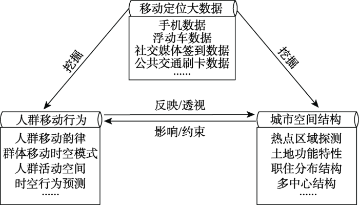
人群移动时空行为和城市空间结构的关系一直是人文地理学研究的焦点问题。如图1所示,人群移动时空行为可反映和透视出城市空间结构特征;反过来,城市空间结构会约束和影响人群在城市中的移动行为。移动定位大数据为研究城市人群移动时空行为和空间结构提供了新的机遇和视角。从移动定位大数据中不仅可直接挖掘出人群移动的时空行为规律和城市空间结构特征,还可探索二者之间的相互作用关系。近年来,学者们开始从移动定位数据中挖掘有用的信息,加深对城市人群移动时空行为和城市空间结构的理解,并涌现出大量的研究成果。本文从人群移动时空行为、城市空间结构特征以及两者关系三方面综述国内外最新研究进展。
图1 人群移动时空行为与城市空间结构关系
Fig.1 Relationship between human mobility and urban spatial structure
居民出行行为研究是理解人类活动和城市空间复杂关系的重要途径。轨迹大数据使得我们可从不同的视角研究城市大规模群体移动行为,包括从时间的角度分析人群出行动态韵律,从时空的角度提取群体移动的时空模式,从停留的角度提取人群活动的锚点与活动类型识别,从空间角度分析人群活动空间特征和从通勤的角度研究居民移动行为等。
3.1.1 人群移动韵律分析
从时间的角度看,城市居民的出行具有很强的节奏性和周期性(Sevtsuk et al, 2010)。城市郊区的居民通勤具有很强的规律,无论是工作、上学、服务还是休闲等活动,人群每天的移动都遵循相似的时间节奏(Ahas et al, 2010)。在世界上不同的地方由于地域文化差异,人群每天活动的时间存在差异性,手机数据使得我们可以轻易地比较世界不同地方的人群活动的时空地理文化差异(Ahas et al, 2015)。人群移动模式具有很强的时间规律性,为检测这种规律在任何时间尺度下的稳定性,Zhong等(2016)分别采用新加坡、伦敦、北京的公交刷卡数据分析不同时间尺度下这种规律的稳定性,发现规律性的变化与时间分辨率存在非线性的关系。
3.1.2 群体移动时空模式
人群的移动具有很强的动态节奏性,由于城市空间结构功能存在差异,在城市不同的区域移动模式存在差异,识别城市中群体移动时空模式有助于深入理解城市不同空间结构与人群移动之间的关系。多数研究通过构建描述人群动态变化指标的时间序列,然后运用不同的方法被用来识别提取出城市中典型的人群移动时空模式,并进一步分析群体移动模式与城市土地利用的关系(Liu et al, 2012; Yang, Fang et al, 2016; 杨喜平等, 2016; Gong et al, 2017)。
3.1.3 锚点提取与活动类型识别
轨迹中的锚点是指人在移动过程中重要的停留驻点,表示人为了从事某种活动在这些地方进行了停留;而人对活动需求是产生移动的根本原因,锚点对人来说是一些比较重要的和有意义的地方。在人的时空间移动行为研究中,大多数研究工作主要关注的是人群移动的部分,忽略了人移动过程中停留行为的分析(萧世伦等, 2014),因此还需多关注城市人群的停留模式(徐金磊等, 2015)。从轨迹中识别出人的移动行为和停留行为,构建人群移动出行网络结构模型,可帮助深入理解人的出行结构特征(Schneider et al, 2013)。移动和停留是轨迹中2个重要组成部分,从轨迹中识别出活动锚点,结合地理空间环境的语义信息,推测出停留锚点的活动类型,丰富轨迹的语义信息,帮助理解人们出行的活动需求,从而根据活动类型之间的变化预测人群的移动(Huang et al, 2015)。
从轨迹中识别出人的停留锚点,需进一步确定人们在锚点处所从事的活动类型,人们对这些活动的需求才是决定其出行的潜在动力因素,因此有必要识别出锚点的活动类型,来丰富轨迹的语义信息(Alvares et al, 2007)。学者们通过利用实际的地理空间环境信息(POI),结合出行问卷调查数据,通过建立概率模型来推测锚点的活动类型(Furletti et al, 2013;Diao et al, 2015; Gong et al, 2016)。识别人群的活动目的给轨迹添加语义标签非常有意义,但目前只能从概率上推测人群的活动类型,并且识别的结果仍未能得到准确的验证。
3.1.4 人群活动空间分析
活动空间是由人一天中所访问的位置所构成的空间活动范围,是人的时空间行为研究中的一个重要的内容,可用来衡量居民对城市空间的利用状况(柴彦威等, 2008)。传统的活动空间研究主要采用出行文件调查数据,最近移动定位技术的发展为其提供了新的数据采集方法。柴彦威(2013)将传统问卷调查和GPS技术结合对北京2个居住区的样本居民进行了为期一周的时空数据采集,并对采集的数据质量进行评价。随后利用采集的数据对城市居民的日常活动空间进行一系列研究,如社区居民工作日和休息日的日常活动空间及对城市空间利用的影响因素,城市不同社区居民的日常活动的时空分布及社区分异性等(张艳等, 2014)。大数据使得分析大规模群体的活动空间成为可能。王波等(2014)利用新浪微博签到大数据分析了南京市区活动空间的总体特征,认为在信息时代距离的二重作用可能使城市活动空间出现极化。最近,手机数据也被应用于城市居民活动空间的研究。Xu等(2015)基于深圳市手机数据识别出用户居住位置,并采用回旋半径衡量用户基于居住位置的活动空间,分析了城市不同区域人群基于家的活动空间的差异,发现深圳市人群的活动空间具有非常明显的南北差异特性,与该城市的经济发展和交通特点一致。此外,他还采用3个指标(每天的活动范围、活动锚点的数量和移动频率)来比较深圳和上海2个城市的人群的活动空间差异(Xu et al, 2016)。大规模的时空轨迹数据还可使研究者分析城市人群活动空间的分布模型,可分析城市中不同性别群体和不同年龄群体对城市空间的使用情况(Yuan et al, 2016)。
3.1.5 人群移动时空预测性研究
2017年,《Science》期刊专门针对时空活动预测研究出了一期“Prediction and its limits”为主题的专题研究报告,收集了大数据在政治经济、人口、政策和冲突等方面的以数据为驱动的预测研究,并指出预测人类行为是未来重要的研究前沿问题(Jasny et al, 2017)。轨迹大数据为人群时空移动行为预测提供了良好的机遇。传统认为个体的移动具有很大的随机性,可用一些随机模型或Lévy飞行模型来对其解释,而学者们通过利用手机数据发现人群移动具有很强的规律性和可预测性(Gonzalez et al, 2008; Song et al, 2010)。在群体移动预测方面,方志祥等(2017)基于海量手机轨迹数据,运用时空概率转移矩阵来定量化描述城市不同区域间人群流动时空特征,结合马尔科夫链和贝叶斯定理预测城市不同区域上基站服务用户数量,为通讯公司优化基站布局提供参考。
城市空间结构是指城市各个要素通过其内在机制的相互作用而形成的相对区位关系和空间形态,是长期过程中人类空间活动和区位选择的积累结果。人群在城市中的移动行为可潜在地反映和透视城市空间结构特征,如城市居民出行热点区域、土地利用结构、多中心结构、城市空间的可达性和职住空间分布结构特征等。
3.2.1 热点区域的探测及语义分析
人群活动热点区域是指人群的活动显著高于其邻近区域的地方,这些热点可帮助我们了解到城市中吸引力较高、人群出行需求较高、交通设施中较关键的区域。在城市中,由于不同的活动对时间的依赖程度不同,如工作、购物、休闲等活动对人群吸引的时间段是不一样的,故城市中热点区域对时间具有依赖性(Yue et al, 2009)。城市内旅游景点具有很强的吸引力,基于新浪微博签到数据,采用空间聚类方法可识别出城市旅游热点区域(Shao et al, 2017)。在识别人群出行需求热点方面,学者们基于核密度提出了不同的方法来识别人群出行热点(Hu et al, 2014; Yang, Zhao et al, 2016; Zhao et al, 2017)。在交通关键设施方面,Zhou等(2015)采用武汉市出租车轨迹数据,结合核密度和等高线来识别城市中路网中功能关键的热点位置,并分析了这些关键位置网络结构随时间的动态变化模式。
网络文本中蕴含着丰富的地理信息,通过利用数据挖掘技术从网络文本中发现有意义的地理知识,是地理信息发展的一个新的方向(余丽等, 2015)。最近,社交网络数据开始被广泛应用于人群活动的研究,一些学者用社会调查数据来衡量Twitter数据是否能作为研究人群移动的指标,尝试将社交网络数据整合到地理信息系统(Steiger et al, 2015; Andris 2016)。社交网络数据包含用户的一些社会属性信息,如年龄、性别及发布消息的位置和时间等信息,因此可用于研究城市中不同社会群体活动的时空模式和城市空间结构等(Longley et al, 2015; Huang et al, 2016)。社交文本中包括用户对所参与活动的描述信息,利用自然语言处理技术从文本中挖掘出这些活动信息,提取出城市中用户感兴趣的区域,并添加地理语义主题标签,了解城市中不同位置群体所从事的主要活动信息(Hu et al, 2015; Kim et al, 2016;谢永俊等,2017)。
3.2.2 土地利用类型识别
城市土地利用与人群移动时空模式之间密切相关,不同的土地利用会产生不同的人群移动模式。学者们开始利用手机数据、出租车和公交刷卡数据、社交媒体签到数据来推测城市的功能区域。总体的思路为:先将城市分割成不同的空间分析单元,构建每个单元内人群活动的时间序列,然后采用机器学习中分类方法(如模糊C均值等)对时间序列进行分类;再根据每一类人群的变化模式来分析其土地利用类型(Pei et al, 2014)。通过将出租车轨迹数据与城市POI结合,或考虑不同区域间的交互模式,利用主题推断模型或EM算法进行聚类,从而推测出土地利用类型(Liu et al, 2016; Gao et al, 2017)。此外,Zhi等(2016)采用社交媒体签到数据,采用矩阵分解和K-means聚类方法联合探测出5种典型的城市功能区。即使在同一种功能用地上,人群的活动也是随时间不断变化的,通过融合多源人群活动数据可提高对城市功能的了解(Tu et al, 2017)。
3.2.3 城市多中心结构研究
人群在城市中不同区域间移动可反映这些区域之间的交互关系,这种交互关系潜在地反映城市不同区域的联系紧密程度以及城市多中心结构。通过分析人群在城市中的空间分布,可识别城市中心及多中心结构(钮心毅等, 2014; Sun et al, 2016)。城市中人群的移动可反映出城市不同区域之间的交互强度,从轨迹数据中提取出用人群移动的OD位置,构建基于人群移动流量的网络,利用复杂网络中的社区探索算法进行社区发现,从而可以发现网络中交互强度较大的人群移动局部紧密社区,发现城市中潜在的居民出行多中心社区结构,为城市规划提供参考(Liu X et al, 2015; Kang et al, 2016)。为了减小可塑性面积单元问题(MAUP),Zhu等(2017)利用北京市出租车数据,以街道作为分析单元分析城市人群移动时空模式和社区结构,发现城市街道可作为面单元的一个补充来缓解MAUP问题。
3.2.4 职住空间分布结构研究
城市居民职住空间分布和平衡一直是交通领域研究的重点,随着居民活动大数据的兴起,职住关系的研究也进入新的阶段,通过从人群活动数据中识别居民的居住位置和工作位置,这种大规模的人群活动数据能够使我们全面了解城市职住空间分布特征。目前,学者们用大数据进行职住分布的研究主要包括:职住地识别方法研究(许宁等, 2014; 曹瑞等, 2016),职住关系的平衡(Long et al, 2015),通勤圈的识别(丁亮等, 2015)和就业中心体系测度(丁亮等, 2016)。基于识别的居民职住位置,构建居民出行的OD矩阵,通过分析居民出行起点和终点的分布特征,设计聚类算法来对其进行聚类,发现城市中不同区域居民出行的主要空间交互模式和出行量的时空特征(Zhu et al, 2014; 程静等, 2016)。
3.2.5 城市空间的可达性研究
可达性是衡量城市空间中某一地方到其他地方便捷性的一种指标,可用于反映城市空间结构中区位的公平性和优先级(陈洁等, 2007)。浮动车数据不仅能反映城市不同区域人群的出行起点和终点,同时也可反映城市道路网的动态路况等信息,因此被广泛应用于可达性研究(Cui et al, 2016)。城市路网的交通状况是随着时间和空间不断变化的,因此可达性也是不断变化的。考虑城市道路网的实时速度和城市道路网行程时间的不确定性,可计算城市POI和特定位置的动态可达性(Chen et al, 2017)。此外,手机数据也被用于衡量可达性,如可定量分析非洲居民到公共健康设施的可达性及对健康预防的影响(Wesolowski et al, 2015)。
移动定位大数据使得学者们可从宏观、微观、静态、动态和时空等多个角度来研究人群移动行为和城市空间结构,加深对两者关系的理解。目前,人群移动性研究还存在以下一些不足,需要未来进一步提升:
(1) 由于使用目的和感知设备的差异,不同的数据源在采样规模、群体类型和时空分辨率等方面具有各自特点,这些数据在研究人群移动模式时也具有各自优缺点,因此在研究人群移动时出现偏见(Lu et al, 2017)。在未来,通过融合多源轨迹数据能更全面更详细地了解城市居民出行的全过程,深入理解居民出行行为特点和对城市空间的使用规律。
(2) 随着时空轨迹数据的丰富,时空分析已成为研究人群出行行为的重要手段。时间地理学理论为分析个体时空行为奠定了理论基础,已经能初步在GIS中对个体之间行为进行表达和分析(陈洁等, 2016),但对于更复杂的个体活动和交互行为(如活动的碎片化、多活动同时进行或虚拟空间的活动等)仍难以实现,因此,还需要进一步丰富时空行为分析的理论和方法。
(3) 轨迹大数据只是记录了个体在城市中移动的时空位置信息,缺乏个体出行过程中参与活动的语义信息和城市环境信息的描述,在人群活动的属性信息描述方面无法与传统调查数据相比,所以还需深入研究完整的时空语义建模理论。
人群移动行为和城市空间结构及其两者关系一直是地理学领域研究的重点问题,对城市的公共安全、交通、规划和疾病传播具有巨大的潜在应用价值。移动定位大数据给人群移动行为和城市空间结构研究带来了新的机遇,本文分别从人群移动行为和城市空间结构2个方面对近3年国内外相关研究进行综述,可以得出目前研究尚主要处于知识发现阶段。大部分研究是以“数据-人群移动行为-城市空间结构”为思路,即通过从数据中挖掘人的移动模式,如出行动态规律、群体移动时空模式、活动空间等,有助于理解城市人群活动的时空规律,进一步透视城市空间的形态结构、土地利用结构、职住分布结构和可达性等特征。未来,需要融合多源移动定位数据研究时空行为分析的理论和方法,丰富轨迹数据的语义信息,进一步探索人群移动行为和城市空间结构之间的相互作用规律,深入理解两者的耦合关系。
The authors have declared that no competing interests exist.
| [38] |
Extracting urban functional regions from points of interest and human activities on location-based social networks [J].https://doi.org/10.1111/tgis.2017.21.issue-3 URL [本文引用: 1] |
| [39] |
Inferring trip purposes and uncovering travel patterns from taxi trajectory data [J].https://doi.org/10.1080/15230406.2015.1014424 URL [本文引用: 1] 摘要
Global positioning system-enabled vehicles provide an efficient way to obtain large quantities of movement data for individuals. However, the raw data usually lack activity information, which is highly valuable for a range of applications and services. This study provides a novel and practical framework for inferring the trip purposes of taxi passengers such that the semantics of taxi trajectory data can be enriched. The probability of points of interest to be visited is modeled by Bayes’ rules, which take both spatial and temporal constraints into consideration. Combining this approach with Monte Carlo simulations, we conduct a study on Shanghai taxi trajectory data. Our results closely approximate the residents’ travel survey data in Shanghai. Furthermore, we reveal the spatiotemporal characteristics of nine daily activity types based on inference results, including their temporal regularities, spatial dynamics, and distributions of trip lengths and directions. In the era of big data, we encounter the dilemma of “trajectory data rich but activity information poor” when investigating human movements from various data sources. This study presents a promising step toward mining abundant activity information from individuals’ trajectories.
|
| [40] |
Exploring the spatiotemporal structure of dynamic urban space using metro smart card records [J].https://doi.org/10.1016/j.compenvurbsys.2017.02.003 URL [本文引用: 1] 摘要
61An eigendecomposition method is proposed to capture the common patterns of passengers’ variation among all metro stations.61EigenStaion can reveal the spatial heterogeneity of the dynamic space around the metro stations using low dimensional structures61The structure of EigenStation is highly related to the structure of land use around metro station.
|
| [41] |
Understanding individual human mobility patterns .https://doi.org/10.1038/nature06958 URL PMID: 18528393 [本文引用: 1] 摘要
Despite their importance for urban planning, traffic forecasting, and the spread of biological and mobile viruses, our understanding of the basic laws governing human motion remains limited thanks to the lack of tools to monitor the time resolved location of individuals. Here we study the trajectory of 100,000 anonymized mobile phone users whose position is tracked for a six month period. We find that in contrast with the random trajectories predicted by the prevailing Levy flight and random walk models, human trajectories show a high degree of temporal and spatial regularity, each individual being characterized by a time independent characteristic length scale and a significant probability to return to a few highly frequented locations. After correcting for differences in travel distances and the inherent anisotropy of each trajectory, the individual travel patterns collapse into a single spatial probability distribution, indicating that despite the diversity of their travel history, humans follow simple reproducible patterns. This inherent similarity in travel patterns could impact all phenomena driven by human mobility, from epidemic prevention to emergency response, urban planning and agent based modeling.
|
| [42] |
Extracting and understanding urban areas of interest using geotagged photos [J].https://doi.org/10.1016/j.compenvurbsys.2015.09.001 URL [本文引用: 1] 摘要
61We propose a framework for extracting and understanding urban AOI from geotagged photos.61We design an experiment to construct optimal polygons from point clusters.61We mine knowledge from the extracted AOI, and investigate their spatiotemporal dynamics.61An online system has been developed as a proof-of-concept to show the AOI in different cities.
|
| [43] |
Detecting and analyzing mobility hotspots using surface networks [J].https://doi.org/10.1111/tgis.12076 URL [本文引用: 1] 摘要
Abstract Capabilities for collecting and storing data on mobile objects have increased dramatically over the past few decades. A persistent difficulty is summarizing large collections of mobile objects. This article develops methods for extracting and analyzing hotspots or locations with relatively high levels of mobility activity. We use kernel density estimation (KDE) to convert a large collection of mobile objects into a smooth, continuous surface. We then develop a topological algorithm to extract critical geometric features of the surface; these include critical points (peaks, pits and passes) and critical lines (ridgelines and course-lines). We connect the peaks and corresponding ridgelines to produce a surface network that summarizes the topological structure of the surface. We apply graph theoretic indices to analytically characterize the surface and its changes over time. To illustrate our approach, we apply the techniques to taxi cab data collected in Shanghai, China. We find increases in the complexity of the hotspot spatial distribution during normal activity hours in the late morning, afternoon and evening and a spike in the connectivity of the hotspot spatial distribution in the morning as taxis concentrate on servicing travel to work. These results match with scientific and anecdotal knowledge about human activity patterns in the study area.
|
| [44] |
Activity patterns, socioeconomic status and urban spatial structure: What can social media data tell us? [J].https://doi.org/10.1080/13658816.2016.1145225 URL [本文引用: 1] |
| [45] |
Predicting human mobility with activity changes [J].https://doi.org/10.1080/13658816.2015.1033421 URL [本文引用: 1] 摘要
Human mobility patterns can provide valuable information in understanding the impact of human behavioral regularities in urban systems, usually with a specific focus on traffic prediction, public health or urban planning. While existing studies on human movement have placed huge emphasis on spatial location to predict where people go next, the time dimension component is usually being treated with oversimplification or even being neglected. Time dimension is crucial to understanding and detecting human activity changes, which play a negative role in prediction and thus may affect the predictive accuracy. This study aims to predict human movement from a spatio-temporal perspective by taking into account the impact of activity changes. We analyze and define changes of human activity and propose an algorithm to detect such changes, based on which a Markov chain model is used to predict human movement. The Microsoft GeoLife dataset is used to test our methodology, and the data of two selected users is used to evaluate the performance of the prediction. We compare the predictive accuracy (R2) derived from the data with and without implementing the activity change detection. The results show that theR2is improved from 0.295 to 0.762 for the user with obvious activity changes and from 0.965 to 0.971 for the user without obvious activity changes. The method proposed by this study improves the accuracy in analyzing and predicting human movement and lays the foundation for related urban studies.
|
| [46] |
Prediction and its limits .https://doi.org/10.1126/science.355.6324.468 URL [本文引用: 1] |
| [47] |
Understanding operation behaviors of taxicabs in cities by matrix factorization [J].https://doi.org/10.1016/j.compenvurbsys.2016.08.002 URL [本文引用: 1] 摘要
Taxicabs play significant roles in public transport systems in large cities. To meet repetitive demands of daily intra-urban travels, cabdrivers acquire self-organized habitual operation behaviors in space and time, largely with assistance of their longitudinal operating experience. Recognizing those collective operation behavior patterns of taxicabs will enable us to better design and implement public transport services and urban development plan. In this paper, we systematically study patterns of the spatial supply of 6000 + taxicabs in Wuhan, China based on a monthly collection of their digital traces and the non-negative matrix factorization method. We successfully identify a set of high-level statistical features of the spatial operation behaviors of taxicabs in Wuhan, providing valuable insights to our knowledge of the demand and supply of taxicabs in (similar) large cities. First, we decouple several spatially cohesive regions with intensive internal taxicab travels (termed as demand regions ), which intuitively reveal the well-known multi-sectored urban configuration of Wuhan. Second, by applying the non-negative matrix factorization to taxicab's longitudinal traces, we uncover remarkably self-organized operation patterns of cabdrivers in space (termed as supply regions ) as reactions to the sectored distribution of daily travel behaviors. We find that a large proportion of cabdrivers frequently operate within single specific service area and a small proportion of taxicabs works as shifting tools between different service areas. Last, we focus on performances of taxicabs with distinct spatial operation behaviors and unveil their statistical characteristics in terms of frequency, duration and distance with passenger on board. Our work demonstrates the great potential to understand and improve urban mobility and public transport system from cabdrivers' collective intelligence.
|
| [48] |
Discovery of local topics by using latent spatio-temporal relationships in geo-social media [J].https://doi.org/10.1080/13658816.2016.1146956 URL [本文引用: 1] 摘要
Abstract Social networks have played a crucial role as information channels for people to understanding their daily lives beyond merely being communication tools. In particular, coupling social networks with geographic location has boosted the worth of social media to not only enable comprehension of the effects of natural phenomena such as global warming and disasters, but also the social patterns of human societies. However, the high rate of social data generation and the large amounts of noisy data makes it difficult to directly apply social media to decision-making processes. This article proposes a new system of analyzing the spatio-temporal patterns of social phenomena in real time and the discovery of local topics based on their latent spatio-temporal relationships. We will first describe a model that represents the local patterns of populations of geo-tagged social media. We will then define a local topic whose keywords share a region in space and time and present a system implementation based on existing open source technologies. We evaluated the model of local topics with several ways of visualization in experiments and demonstrated a certain social pattern from a dataset of daily Twitter streams. The results obtained from experiments revealed certain keywords had a strong spatio-temporal proximity even though they did not occur in the same message.
|
| [49] |
Revealing travel patterns and city structure with taxi trip data [J].https://doi.org/10.1016/j.jtrangeo.2015.01.016 URL [本文引用: 2] 摘要
Delineating travel patterns and city structure has long been a core research topic in transport geography. Different from the physical structure, the city structure beneath the complex travel-flow system shows the inherent connection patterns within the city. On the basis of taxi-trip data from Shanghai, we built spatially embedded networks to model intra-city spatial interactions and to introduce network science methods into the analysis. The community detection method is applied to reveal sub-regional structures, and several network measures are used to examine the properties of sub-regions. Considering the differences between long- and short-distance trips, we reveal a two-level hierarchical polycentric city structure in Shanghai. Further explorations of sub-network structures demonstrate that urban sub-regions have broader internal spatial interactions, while suburban centers are more influential on local traffic. By incorporating the land use of centers from a travel-pattern perspective, we investigate sub-region formation and the interaction patterns of center ocal places. This study provides insights into using emerging data sources to reveal travel patterns and city structures, which could potentially aid in developing and applying urban transportation policies. The sub-regional structures revealed in this study are more easily interpreted for transportation-related issues than for other structures, such as administrative divisions.
|
| [50] |
Incorporating spatial interaction patterns in classifying and understanding urban land use [J].https://doi.org/10.1080/13658816.2015.1086923 URL [本文引用: 1] 摘要
Land use classification has benefited from the emerging big data, such as mobile phone records and taxi trajectories. Temporal activity variations derived from these data have been used to interpret and understand the land use of parcels from the perspective of social functions, complementing the outcome of traditional remote sensing methods. However, spatial interaction patterns between parcels, which could depict land uses from a perspective of connections, have rarely been examined and analysed. To leverage spatial interaction information contained in the above-mentioned massive data sets, we propose a novel unsupervised land use classification method with a new type of place signature. Based on the observation that spatial interaction patterns between places of two specific land uses are similar, the new place signature improves land use classification by trading off between aggregated temporal activity variations and detailed spatial interactions among places. The method is validated with a case study using taxi trip data from Shanghai.
|
| [51] |
Social sensing: A new approach to understanding our socioeconomic environments [J].https://doi.org/10.1080/00045608.2015.1018773 URL [本文引用: 1] 摘要
The emergence of big data brings new opportunities for us to understand our socioeconomic environments. We use the term social sensing for such individual-level big geospatial data and the associated analysis methods. The word sensing suggests two natures of the data. First, they can be viewed as the analogue and complement of remote sensing, as big data can capture well socioeconomic features while conventional remote sensing data do not have such privilege. Second, in social sensing data, each individual plays the role of a sensor. This article conceptually bridges social sensing with remote sensing and points out the major issues when applying social sensing data and associated analytics. We also suggest that social sensing data contain rich information about spatial interactions and place semantics, which go beyond the scope of traditional remote sensing data. In the coming big data era, GIScientists should investigate theories in using social sensing data, such as data representativeness and quality, and develop new tools to deal with social sensing data.
|
| [1] |
基于智能卡数据的地铁周边职住用地识别与分析 [J].https://doi.org/10.14188/j.2095-6045.2016.03.018 URL [本文引用: 1] 摘要
针对地铁系统,本文利用智能卡的地铁刷卡时空数据,重建了地铁站点客流量的时间分布,在此基础上进行聚类分析,识别了地铁站点周边的职住用地,并利用GIS手段进行了空间可视化分析,最后采用详细建筑GIS数据进行了验证。实验结果表明。地铁站点周边的土地利用类别对居民地铁出行需求有重要影响。本研究为理解城市土地利用和交通系统的互动提供了新途径。
Identification and analysis of home and work regions in the vicinity of metro stations using smart card data [J].https://doi.org/10.14188/j.2095-6045.2016.03.018 URL [本文引用: 1] 摘要
针对地铁系统,本文利用智能卡的地铁刷卡时空数据,重建了地铁站点客流量的时间分布,在此基础上进行聚类分析,识别了地铁站点周边的职住用地,并利用GIS手段进行了空间可视化分析,最后采用详细建筑GIS数据进行了验证。实验结果表明。地铁站点周边的土地利用类别对居民地铁出行需求有重要影响。本研究为理解城市土地利用和交通系统的互动提供了新途径。
|
| [52] |
Urban land uses and traffic 'source-sink areas': Evidence from GPS-enabled taxi data in Shanghai [J].https://doi.org/10.1016/j.landurbplan.2012.02.012 URL [本文引用: 1] |
| [53] |
Combining smart card data and household travel survey to analyze jobs-housing relationships in Beijing [J].https://doi.org/10.1016/j.compenvurbsys.2015.02.005 URL |
| [2] |
北京居民活动与出行行为时空数据采集与管理 [J].https://doi.org/10.11821/yj2013030006 URL [本文引用: 1] 摘要
本研究对传统活动日志调查与基于GPS、LBS的移动数据采集在居民活动—移动数据的获取和应用方面进行对比,并以2010年7月在北京进行的居民活动与移动调查为例,探讨了个体行为时空数据采集的方法、存在问题和处理方式。北京市的实验调查采取活动日志调查与基于GPS、GSM两种不同定位方式的移动数据采集相结合的方法,以定位设备为基础、以互动式调查网站为平台、以面对面和电话访谈为补充,对天通苑和亦庄两个郊区居住区的样本居民进行了为期一周的行为时空数据采集。针对时空轨迹和活动日志存在的问题分别进行处理,并对数据质量进行管理,旨在为城市活动—移动系统研究中的精细化的数据采集与管理提供理论、方法和实践经验。
The collection and management of space-time data of individual behavior based on location-based technologies: A case study of activity-travel survey in Beijing [J].https://doi.org/10.11821/yj2013030006 URL [本文引用: 1] 摘要
本研究对传统活动日志调查与基于GPS、LBS的移动数据采集在居民活动—移动数据的获取和应用方面进行对比,并以2010年7月在北京进行的居民活动与移动调查为例,探讨了个体行为时空数据采集的方法、存在问题和处理方式。北京市的实验调查采取活动日志调查与基于GPS、GSM两种不同定位方式的移动数据采集相结合的方法,以定位设备为基础、以互动式调查网站为平台、以面对面和电话访谈为补充,对天通苑和亦庄两个郊区居住区的样本居民进行了为期一周的行为时空数据采集。针对时空轨迹和活动日志存在的问题分别进行处理,并对数据质量进行管理,旨在为城市活动—移动系统研究中的精细化的数据采集与管理提供理论、方法和实践经验。
|
| [54] |
Geo-temporal Twitter demographics [J].https://doi.org/10.1080/13658816.2015.1089441 URL [本文引用: 1] |
| [55] |
Understanding the representativeness of mobile phone location data in characterizing human mobility indicators [J].https://doi.org/10.3390/ijgi6010007 URL [本文引用: 1] |
| [3] |
基于活动分析法的人类空间行为研究 [J].https://doi.org/10.3969/j.issn.1000-0690.2008.05.002 URL [本文引用: 1] 摘要
居民日常活动空间和城市日常活动系统是人类空间行为研究中的重要内容,直接反映行为空间形成机制、分布特征及其与实体空间的相互关系,并为城市社会生活及其空间体系研究提供了重要的微观视角。通过行为空间研究中若干关键问题进行探讨,认为基于日常活动空间的活动分析法能够很好的整合和处理这些问题,在对活动分析法相关概念和几个重要方法介绍的基础上,尝试提出基于活动分析法的人类空间行为研究的思路与框架。
A activity-based approach to human spatial behavior research [J].https://doi.org/10.3969/j.issn.1000-0690.2008.05.002 URL [本文引用: 1] 摘要
居民日常活动空间和城市日常活动系统是人类空间行为研究中的重要内容,直接反映行为空间形成机制、分布特征及其与实体空间的相互关系,并为城市社会生活及其空间体系研究提供了重要的微观视角。通过行为空间研究中若干关键问题进行探讨,认为基于日常活动空间的活动分析法能够很好的整合和处理这些问题,在对活动分析法相关概念和几个重要方法介绍的基础上,尝试提出基于活动分析法的人类空间行为研究的思路与框架。
|
| [56] |
A new insight into land use classification based on aggregated mobile phone data [J].https://doi.org/10.1080/13658816.2014.913794 URL [本文引用: 1] 摘要
Land-use classification is essential for urban planning. Urban land-use types can be differentiated either by their physical characteristics (such as reflectivity and texture) or social functions. Remote sensing techniques have been recognized as a vital method for urban land-use classification because of their ability to capture the physical characteristics of land use. Although significant progress has been achieved in remote sensing methods designed for urban land-use classification, most techniques focus on physical characteristics, whereas knowledge of social functions is not adequately used. Owing to the wide usage of mobile phones, the activities of residents, which can be retrieved from the mobile phone data, can be determined in order to indicate the social function of land use. This could bring about the opportunity to derive land-use information from mobile phone data. To verify the application of this new data source to urban land-use classification, we first construct a vector of aggregated mobile phone data to characterize land-use types. This vector is composed of two aspects: the normalized hourly call volume and the total call volume. A semi-supervised fuzzy c-means clustering approach is then applied to infer the land-use types. The method is validated using mobile phone data collected in Singapore. Land use is determined with a detection rate of 58.03%. An analysis of the land-use classification results shows that the detection rate decreases as the heterogeneity of land use increases, and increases as the density of cell phone towers increases.
|
| [57] |
Exploring the capacity of social media data for modelling travel behaviour: Opportunities and challenges [J].https://doi.org/10.1016/j.trc.2016.12.008 URL [本文引用: 1] |
| [4] |
可达性度量方法及应用研究进展评述 [J].https://doi.org/10.3969/j.issn.1007-6301.2007.05.011 URL [本文引用: 1] 摘要
可达性一直是地理学、土木建筑工程设计、交通运输经济学等学科的研究热点。已有的各种可达性度量方法目前已广泛应用于交通网络与城镇发展研究、交通基础设施的区域经济效应评价、选址分析、园林景观规划、社会文化等多个研究领域。随着应用需求的持续加大和技术研究的不断深入,可达性度量方法也在快速发展,其度量体系正在形成。本文首先从两个层面对可达性的涵义进行全面阐述;在此基础上,从网络特性的角度对拓扑法、距离法、累积机会法、等值线法、重力模型法、平衡系数法、时空法、效用法等目前常用的可达性度量方法进行系统分类,并且从可达性影响因素入手对各种度量方法进行综合比较与评述;然后,针对不同的应用领域,对各种度量方法的应用研究现状进行详细论述与剖析;最后,对可达性研究的发展方向进行深入讨论与展望。
Advance in accessibility evaluation approaches and applications [J].https://doi.org/10.3969/j.issn.1007-6301.2007.05.011 URL [本文引用: 1] 摘要
可达性一直是地理学、土木建筑工程设计、交通运输经济学等学科的研究热点。已有的各种可达性度量方法目前已广泛应用于交通网络与城镇发展研究、交通基础设施的区域经济效应评价、选址分析、园林景观规划、社会文化等多个研究领域。随着应用需求的持续加大和技术研究的不断深入,可达性度量方法也在快速发展,其度量体系正在形成。本文首先从两个层面对可达性的涵义进行全面阐述;在此基础上,从网络特性的角度对拓扑法、距离法、累积机会法、等值线法、重力模型法、平衡系数法、时空法、效用法等目前常用的可达性度量方法进行系统分类,并且从可达性影响因素入手对各种度量方法进行综合比较与评述;然后,针对不同的应用领域,对各种度量方法的应用研究现状进行详细论述与剖析;最后,对可达性研究的发展方向进行深入讨论与展望。
|
| [58] |
Developing travel time estimation methods using sparse GPS data [J].https://doi.org/10.1080/15472450.2016.1154764 URL [本文引用: 1] 摘要
(2016). Developing travel time estimation methods using sparse GPS data. Journal of Intelligent Transportation Systems: Vol. 20, No. 6, pp. 532-544. doi: 10.1080/15472450.2016.1154764
|
| [59] |
Unravelling daily human mobility motifs [J].https://doi.org/10.1098/rsif.2013.0246 URL [本文引用: 1] |
| [5] |
面向人类行为研究的时空GIS [J].https://doi.org/10.3724/SP.J.1047.2016.01583 URL [本文引用: 1] 摘要
人类时空行为是地理学、物理学、规划学、流行病学等多学科共同关注的研究主题.时空GIS面向地理时空数据的建模与分析需求,注重时间与空间的一体化表达,为人类行为特征分析与规律探索提供基础方法支撑.然而,现有时空GIS在人类行为时空过程表达以及人类行为与时空场境交互分析等方面存在不足.本文通过深度融合时间地理学理论,提出一种面向人类行为研究的时空GIS方法,以丰富与完善现有的时空GIS方法体系.在深入解读时间地理学中"情境"、"企划"等核心概念的基础上,本文分别从情境要素存在性动态表达、情境要素相关性动态理解及情境要素变化的动态感知等方面探讨拓展现有时空GIS方法的可行性.
A space-time GIS approach for human behavior studies [J].https://doi.org/10.3724/SP.J.1047.2016.01583 URL [本文引用: 1] 摘要
人类时空行为是地理学、物理学、规划学、流行病学等多学科共同关注的研究主题.时空GIS面向地理时空数据的建模与分析需求,注重时间与空间的一体化表达,为人类行为特征分析与规律探索提供基础方法支撑.然而,现有时空GIS在人类行为时空过程表达以及人类行为与时空场境交互分析等方面存在不足.本文通过深度融合时间地理学理论,提出一种面向人类行为研究的时空GIS方法,以丰富与完善现有的时空GIS方法体系.在深入解读时间地理学中"情境"、"企划"等核心概念的基础上,本文分别从情境要素存在性动态表达、情境要素相关性动态理解及情境要素变化的动态感知等方面探讨拓展现有时空GIS方法的可行性.
|
| [60] |
Does urban mobility have a daily routine? Learning from the aggregate data of mobile networks [J].https://doi.org/10.1080/10630731003597322 URL [本文引用: 1] 摘要
Does the distribution of Rome's population follow routine hourly, daily, or weekly patterns? And if it does, how do such patterns vary in different parts of the city? This paper reports on our investigation of the aggregate patterns of urban mobility in Rome, Italy for which we used novel data from a mobile phone operator. Unlike research that chartered urban mobility through individual travel surveys, our research determined the aggregate distribution of Rome's population over time by using the volume of call activity in mobile network cells as the unit of spatial analysis. In this paper, we first illustrate and confirm that there is significant regularity in urban mobility at different hours, days, and weeks. We then show how mobility between network cells differs at various times, and we account for the differences by using demographic, economic, and (built) environment indicators.
|
| [61] |
Extraction and analysis of city's tourism districts based on social media data [J].https://doi.org/10.1016/j.compenvurbsys.2017.04.010 URL [本文引用: 1] 摘要
Through the perspective of tourism, a city as a tourist destination usually consists of multiple tourist attractions such as natural or cultural scenic spots. These attractions scatter in city spaces following some specific forms: clustered in some regions and dispersed in others. It is known that users organize their tours in a city not only according to the distance between different attractions but also according to other factors such as time constraints, expenses, interests, and the similarities between different attractions. Hence, users' travel tours can help us gain a better understanding about the relationships among different attractions at the city scale. In this paper, a methodological framework is developed to detect tourists' spatial-temporal behaviors from social media data, and then such information is used to extract and analyze city's tourism districts. We believe that this city space division will make significant contributions to the fields of urban planning, tourism facility providing, and scenery area constructing. A typical tourism city in China—Huangshan—is selected as our study area for experiments.
|
| [6] |
基于时间序列聚类方法分析北京出租车出行量的时空特征 [J].Analyzing the spatio-temporal characteristics of Beijing's OD trip volume based on time series clustering method [J]. |
| [62] |
Limits of predictability in human mobility [J].https://doi.org/10.1126/science.1177170 URL PMID: 20167789 [本文引用: 1] 摘要
Abstract A range of applications, from predicting the spread of human and electronic viruses to city planning and resource management in mobile communications, depend on our ability to foresee the whereabouts and mobility of individuals, raising a fundamental question: To what degree is human behavior predictable? Here we explore the limits of predictability in human dynamics by studying the mobility patterns of anonymized mobile phone users. By measuring the entropy of each individual's trajectory, we find a 93% potential predictability in user mobility across the whole user base. Despite the significant differences in the travel patterns, we find a remarkable lack of variability in predictability, which is largely independent of the distance users cover on a regular basis.
|
| [63] |
Twitter as an indicator for whereabouts of people? Correlating Twitter with UK census data [J].https://doi.org/10.1016/j.compenvurbsys.2015.09.007 URL [本文引用: 2] 摘要
61Tweets show characteristic spatiotemporal semantic frequencies indicating human activities.61Statistically significant hot- and cold spots of human activity clustered tweets61Strong correlation (r=0.75) of classified tweets with UK census workplace densities61Weak correlation (r=0.08) of classified tweets with UK census residential densities
|
| [7] |
利用手机数据识别上海中心城的通勤区 [J].https://doi.org/10.11819/cpr20150917a URL [本文引用: 1] 摘要
用手机数据识别了用户的日间驻留地、夜间驻留地,从中提取出日间在上海中心城内驻留用户、夜间在中心城内驻留用户,分别计算出其通勤范围。根据其夜间驻留地、日间驻留地的分布密度识别出上海中心城的通勤圈,并将其转换为以街道行政边界为空间单元的中心城通勤区。在中心城及通勤区内,超过97%的居民实现了职住平衡。研究表明上海市域空间结构在"中心城"和"郊区"之间还存在一个"中心城通勤区"层次。中心城通勤区以内、以外区域存在较显著差异。中心城通勤区的识别结果可加深对上海市域空间结构的认识,为在市域范围内分层次、分区域制定有针对性的规划政策提供依据。
Identifying the commuting area of Shanghai central city using mobile phone data [J].https://doi.org/10.11819/cpr20150917a URL [本文引用: 1] 摘要
用手机数据识别了用户的日间驻留地、夜间驻留地,从中提取出日间在上海中心城内驻留用户、夜间在中心城内驻留用户,分别计算出其通勤范围。根据其夜间驻留地、日间驻留地的分布密度识别出上海中心城的通勤圈,并将其转换为以街道行政边界为空间单元的中心城通勤区。在中心城及通勤区内,超过97%的居民实现了职住平衡。研究表明上海市域空间结构在"中心城"和"郊区"之间还存在一个"中心城通勤区"层次。中心城通勤区以内、以外区域存在较显著差异。中心城通勤区的识别结果可加深对上海市域空间结构的认识,为在市域范围内分层次、分区域制定有针对性的规划政策提供依据。
|
| [64] |
An integrated Bayesian approach for passenger flow assignment in metro networks [J].https://doi.org/10.1016/j.trc.2015.01.001 URL [本文引用: 1] 摘要
This paper proposes an integrated Bayesian statistical inference framework to characterize passenger flow assignment model in a complex metro network. In doing so, we combine network cost attribute estimation and passenger route choice modeling using Bayesian inference. We build the posterior density by taking the likelihood of observing passenger travel times provided by smart card data and our prior knowledge about the studied metro network. Given the high-dimensional nature of parameters in this framework, we apply the variable-at-a-time Metropolis sampling algorithm to estimate the mean and Bayesian confidence interval for each parameter in turn. As a numerical example, this integrated approach is applied on the metro network in Singapore. Our result shows that link travel time exhibits a considerable coefficient of variation about 0.17, suggesting that travel time reliability is of high importance to metro operation. The estimation of route choice parameters conforms with previous survey-based studies, showing that the disutility of transfer time is about twice of that of in-vehicle travel time in Singapore metro system.
|
| [65] |
Identifying the city center using human travel flows generated from location-based social networking data [J].https://doi.org/10.1177/0265813515617642 URL [本文引用: 1] |
| [8] |
上海中心城就业中心体系测度: 基于手机信令数据的研究 [J].https://doi.org/10.11821/dlxb201603011 URL [本文引用: 1] 摘要
利用手机信令数据识别上海市域内手机用户的工作地和居住地,获取就业者的通勤数据,测度上海中心城的就业中心体系。首先用就业者工作地数据生成就业密度分布图,基于中心城的就业密度识别就业中心。随后,用就业者工作地和居住地数据分别从就业密度和通勤联系两方面测度各中心的能级、分析各中心的腹地和势力范围。研究发现:1上海中心城的就业中心呈主中心强大的弱多中心体系;2就业密度越高的中心与其他地区的通勤联系一般也越强,但通勤联系在各中心间的差异更显著;3能级越高的中心腹地面积越大,但势力范围不一定越大;4相比于能级,职住功能混合度对职住平衡的影响更大;5缺少就业中心的地区势力范围呈交替状。本研究一定程度上能有助于解决既往就业中心体系研究因空间单元较大、缺少通勤数据在中心识别、通勤联系测度等方面受到的局限,希望能为构建上海中心城就业多中心体系提供帮助。
Measuring the employment center system in Shanghai central city: A study using mobile phone signaling data [J].https://doi.org/10.11821/dlxb201603011 URL [本文引用: 1] 摘要
利用手机信令数据识别上海市域内手机用户的工作地和居住地,获取就业者的通勤数据,测度上海中心城的就业中心体系。首先用就业者工作地数据生成就业密度分布图,基于中心城的就业密度识别就业中心。随后,用就业者工作地和居住地数据分别从就业密度和通勤联系两方面测度各中心的能级、分析各中心的腹地和势力范围。研究发现:1上海中心城的就业中心呈主中心强大的弱多中心体系;2就业密度越高的中心与其他地区的通勤联系一般也越强,但通勤联系在各中心间的差异更显著;3能级越高的中心腹地面积越大,但势力范围不一定越大;4相比于能级,职住功能混合度对职住平衡的影响更大;5缺少就业中心的地区势力范围呈交替状。本研究一定程度上能有助于解决既往就业中心体系研究因空间单元较大、缺少通勤数据在中心识别、通勤联系测度等方面受到的局限,希望能为构建上海中心城就业多中心体系提供帮助。
|
| [66] |
Coupling mobile phone and social media data: A new approach to understanding urban functions and diurnal patterns [J]. |
| [67] |
A comparative analysis of intra-city human mobility by taxi [J].https://doi.org/10.1016/j.physa.2014.10.085 URL [本文引用: 1] 摘要
61We observe common patterns of human mobility by taxi in several cities.61The displacement distributions of taxi trips tend to follow exponential laws.61The trip durations follow log-normal distributions.61The interevent time distributions have log-normal bodies followed by power law tails.61Airports attract large amounts of taxi traffic at a certain distance level.
|
| [9] |
利用终端位置时空转移概率预测通讯基站服务用户规模 [J].
基站服务用户数的预测对通信基站的空间位置选取、通讯服务带宽的配置优化等有重要作用,并为城市公共安全管理方面中的人群聚集预警与群体事件预防提供辅助决策支持。本文利用海量手机轨迹数据,运用时空转移概率定量化描述城市内不同区域间人群流动的时空特性,结合马尔可夫链和贝叶斯定理,构建手机用户群体在基站间的时空转移概率模型,并以此提出一种城市区域尺度上的基站服务用户数预测方法。利用湖北省某城市长达30 d的手机轨迹数据进行模型训练与预测方法验证,实验结果表明:在时间粒度为60 min时,本文提出的方法对8-22时各时段基站服务用户数预测准确率都大于94.8%;在不同时间粒度下对比本文方法、Castro模型、移动平均法,发现在时间粒度大于20 min时,本文方法预测准确率高于另外两种方法。
Using terminal location spatio-temporal transfer probability to predict subscriber base size of communication base station [J].
基站服务用户数的预测对通信基站的空间位置选取、通讯服务带宽的配置优化等有重要作用,并为城市公共安全管理方面中的人群聚集预警与群体事件预防提供辅助决策支持。本文利用海量手机轨迹数据,运用时空转移概率定量化描述城市内不同区域间人群流动的时空特性,结合马尔可夫链和贝叶斯定理,构建手机用户群体在基站间的时空转移概率模型,并以此提出一种城市区域尺度上的基站服务用户数预测方法。利用湖北省某城市长达30 d的手机轨迹数据进行模型训练与预测方法验证,实验结果表明:在时间粒度为60 min时,本文提出的方法对8-22时各时段基站服务用户数预测准确率都大于94.8%;在不同时间粒度下对比本文方法、Castro模型、移动平均法,发现在时间粒度大于20 min时,本文方法预测准确率高于另外两种方法。
|
| [68] |
Quantifying the impact of accessibility on preventive healthcare in sub-Saharan Africa using mobile phone data [J].https://doi.org/10.1097/EDE.0000000000000239 URL [本文引用: 1] |
| [69] |
Understanding aggregate human mobility patterns using passive mobile phone location data: A home-based approach [J].https://doi.org/10.1007/s11116-015-9597-y URL [本文引用: 1] |
| [10] |
基于社会感知计算的游客时空行为研究 [J].Tourists' spatio-temporal behavior based on socially aware computing [J]. |
| [70] |
Another tale of two cities: Understanding human activity space using actively tracked cellphone location data [J]. |
| [71] |
Understanding spatiotemporal patterns of human convergence and divergence using mobile phone location data [J].https://doi.org/10.3390/ijgi5100177 URL [本文引用: 1] |
| [11] |
从 Geomatics 到 Urban Informatics [J].https://doi.org/10.13203/j.whugis20160200 URL [本文引用: 1] 摘要
我国正处在新型城镇化、工业化和信息化的关键时期,城市面临着复杂的经济、社会与生态可持续发展问题。面向城市的地球空间信息学(Geomatics)与互联网、云计算技术持续融合,产生了城市时空大数据,成为了智慧城市的重要战略资源。随着地球空间信息学和信息学、城市科学不断深入交叉融合,城市信息学(Urban Informatics)逐步形成,并正在成为测绘地理信息科学的重要发展方向。城市信息学是以统一的时空基准为框架,以空间信息为载体,以信息技术为支撑,动态采集城市信息并进行处理、分析与服务,支持绿色、低碳、可持续城市发展的交叉学科。本文分析了城市信息的内涵及其与地球空间信息学的相互关系,论述了城市信息学具有动态演变、数据驱动、众源学习、协同决策、学科交叉等典型特征,在此基础上,总结了若干影响学科发展的关键科学问题,最后展望了城市信息学的发展前景。
From Geomatics to Urban Informatics [J].https://doi.org/10.13203/j.whugis20160200 URL [本文引用: 1] 摘要
我国正处在新型城镇化、工业化和信息化的关键时期,城市面临着复杂的经济、社会与生态可持续发展问题。面向城市的地球空间信息学(Geomatics)与互联网、云计算技术持续融合,产生了城市时空大数据,成为了智慧城市的重要战略资源。随着地球空间信息学和信息学、城市科学不断深入交叉融合,城市信息学(Urban Informatics)逐步形成,并正在成为测绘地理信息科学的重要发展方向。城市信息学是以统一的时空基准为框架,以空间信息为载体,以信息技术为支撑,动态采集城市信息并进行处理、分析与服务,支持绿色、低碳、可持续城市发展的交叉学科。本文分析了城市信息的内涵及其与地球空间信息学的相互关系,论述了城市信息学具有动态演变、数据驱动、众源学习、协同决策、学科交叉等典型特征,在此基础上,总结了若干影响学科发展的关键科学问题,最后展望了城市信息学的发展前景。
|
| [72] |
Exploring spatial-temporal patterns of urban human mobility hotspots [J].https://doi.org/10.3390/su8070674 URL [本文引用: 1] 摘要
Understanding human mobility patterns provides us with knowledge about human mobility in an urban context, which plays a critical role in urban planning, traffic management and the spread of disease. Recently, the availability of large-scale human-sensing datasets enables us to analyze human mobility patterns and the relationships between humans and their living environments on an unprecedented spatial and temporal scale to improve decision-making regarding the quality of life of citizens. This study aims to characterize the urban spatial-temporal dynamic from the perspective of human mobility hotspots by using mobile phone location data. We propose a workflow to identify human convergent and dispersive hotspots that represent the status of human mobility in local areas and group these hotspots into different classes according to clustering their temporal signatures. To illustrate our proposed approach, a case study of Shenzhen, China, has been conducted. Six typical spatial-temporal patterns in the city are identified and discussed by combining the spatial distribution of these identified patterns with urban functional areas. The findings enable us to understand the human dynamics in a different area of the city, which can serve as a reference for urban planning and traffic management.
|
| [73] |
Re-identification risk versus data utility for aggregated mobility research using mobile phone location data [J].https://doi.org/10.1371/journal.pone.0140589 URL [本文引用: 1] |
| [12] |
人类活动轨迹的分类、模式和应用研究综述 [J].https://doi.org/10.11820/dlkxjz.2014.07.009 URL [本文引用: 1] 摘要
各种传感器的应用与发展,如车载GPS、手机、公交卡、银行卡等,记录了人类的活动轨迹。这些海量的人类活动轨迹数据中蕴含着人类行为的时空分布模式。通过对这些轨迹的研究可以挖掘个体轨迹模式,理解人类动力学特征,进而为对轨迹预测、城市规划、交通监测等提供支持。因此,研究各类传感器记录的人类活动轨迹数据成为当前的研究热点。本文对人类活动轨迹的获取与表达方式进行剖析,并将人类的活动轨迹按照采样方式和驱动因素的不同分为基于时间间隔采样、基于位置采样和基于事件触发采样等3类轨迹数据。由于各类轨迹数据均由起始点、锚点和一般节点等构成,因而将轨迹模式挖掘的研究按照锚点、出行范围、形状模式、OD流模式、时间模式等进行组织,研究成果揭示人类活动轨迹在时间、空间的从聚模式、周期性等特点。在此基础上,将人类活动轨迹在城市研究中的应用,按照用户轨迹预测、城市动态景观、城市交通模拟与监控、城市功能单元识别以及城市中其他方面的研究应用进行系统综述,认为人类活动模式挖掘是城市规划、城市交通、公共安全等方面应用的基础。
A review on the classification, patterns and applied research of human mobility trajectory [J].https://doi.org/10.11820/dlkxjz.2014.07.009 URL [本文引用: 1] 摘要
各种传感器的应用与发展,如车载GPS、手机、公交卡、银行卡等,记录了人类的活动轨迹。这些海量的人类活动轨迹数据中蕴含着人类行为的时空分布模式。通过对这些轨迹的研究可以挖掘个体轨迹模式,理解人类动力学特征,进而为对轨迹预测、城市规划、交通监测等提供支持。因此,研究各类传感器记录的人类活动轨迹数据成为当前的研究热点。本文对人类活动轨迹的获取与表达方式进行剖析,并将人类的活动轨迹按照采样方式和驱动因素的不同分为基于时间间隔采样、基于位置采样和基于事件触发采样等3类轨迹数据。由于各类轨迹数据均由起始点、锚点和一般节点等构成,因而将轨迹模式挖掘的研究按照锚点、出行范围、形状模式、OD流模式、时间模式等进行组织,研究成果揭示人类活动轨迹在时间、空间的从聚模式、周期性等特点。在此基础上,将人类活动轨迹在城市研究中的应用,按照用户轨迹预测、城市动态景观、城市交通模拟与监控、城市功能单元识别以及城市中其他方面的研究应用进行系统综述,认为人类活动模式挖掘是城市规划、城市交通、公共安全等方面应用的基础。
|
| [74] |
Analyzing the distribution of human activity space from mobile phone usage: An individual and urban-oriented study [J].https://doi.org/10.1080/13658816.2016.1143555 URL [本文引用: 1] |
| [75] |
Mining time-dependent attractive areas and movement patterns from taxi trajectory data [C]// |
| [13] |
基于位置感知设备的人类移动研究综述 [J].A review of human mobility research based on location aware devices [J]. |
| [76] |
Zooming into individuals to understand the collective: A review of trajectory-based travel behaviour studies [J].https://doi.org/10.1016/j.tbs.2013.12.002 URL [本文引用: 1] |
| [77] |
A trajectory clustering approach based on decision graph and data field for detecting hotspots [J].https://doi.org/10.1080/13658816.2016.1213845 URL [本文引用: 1] 摘要
Spatial clustering can be used to discover hotspots in trajectory data. A trajectory clustering approach based on decision graph and data field is proposed as an effective method to select parameters for clustering, to determine the number of clusters, and to identify cluster centers. Synthetic data and real-world taxi trajectory data are utilized to demonstrate the effectiveness of the proposed approach. Results show that the proposed method can automatically determine the parameters for clustering as well as perform efficiently in trajectory clustering. Hotspots are identified and visualized during different times of a single day and at the same times on different days. The dynamic patterns of hotspots can be used to identify crowded areas and events, which are crucial for urban transportation planning and management.
|
| [14] |
基于公共交通智能卡数据的城市研究综述 [J].https://doi.org/10.16361/j.upf.201503009 URL [本文引用: 3] 摘要
基于智能卡的公共交通自动计费系统的广泛应用产生了大量的基于个体的微观时空数据。这种数据不仅记录了持卡者的出行行为,同时也在个体维度揭示了城市空间的使用模式。由于其时空信息丰富、成本低、样本量大的优势,公交卡数据受到了越来越多的城市/交通规划研究者的青睐,开始在城市规划研究中发挥着日益重要的作用。本文主要总结了公共交通智能卡数据在定量城市研究中的应用,综述并比较了国际国内基于公共交通智能卡数据研究的最近进展。综述涵盖了(1)数据处理与起讫推算,(2)公共交通系统的运行与管理,(3)城市空间结构分析,以及(4)出行行为与社会网络等四个方面。最后,总结了已有研究,简要介绍了隐私保护和信息获取等问题,并指出未来可能的研究方向。
A review of urban studies based on transit smart card data [J].https://doi.org/10.16361/j.upf.201503009 URL [本文引用: 3] 摘要
基于智能卡的公共交通自动计费系统的广泛应用产生了大量的基于个体的微观时空数据。这种数据不仅记录了持卡者的出行行为,同时也在个体维度揭示了城市空间的使用模式。由于其时空信息丰富、成本低、样本量大的优势,公交卡数据受到了越来越多的城市/交通规划研究者的青睐,开始在城市规划研究中发挥着日益重要的作用。本文主要总结了公共交通智能卡数据在定量城市研究中的应用,综述并比较了国际国内基于公共交通智能卡数据研究的最近进展。综述涵盖了(1)数据处理与起讫推算,(2)公共交通系统的运行与管理,(3)城市空间结构分析,以及(4)出行行为与社会网络等四个方面。最后,总结了已有研究,简要介绍了隐私保护和信息获取等问题,并指出未来可能的研究方向。
|
| [78] |
Understanding the bias of call detail records in human mobility research [J].https://doi.org/10.1080/13658816.2015.1137298 URL [本文引用: 1] 摘要
Understanding the bias of call detail records in human mobility research. . ???aop.label???. doi: 10.1080/13658816.2015.1137298
|
| [79] |
Latent spatio-temporal activity structures: A new approach to inferring intra-urban functional regions via social media check-in data [J].https://doi.org/10.1080/10095020.2016.1176723 URL [本文引用: 1] |
| [15] |
大数据时代的人类移动性研究 [J].Research on human mobility in big data era [J]. |
| [80] |
Variability in regularity: Mining temporal mobility patterns in London, Singapore and Beijing using smart-card data [J].https://doi.org/10.1371/journal.pone.0149222 URL [本文引用: 1] |
| [81] |
Functionally critical locations in an urban transportation network: Identification and space-time analysis using taxi trajectories [J].https://doi.org/10.1016/j.compenvurbsys.2015.03.001 URL [本文引用: 1] |
| [16] |
轨迹数据挖掘城市应用研究综述 [J].A review on the application research of trajectory data mining in urban cities [J]. |
| [82] |
Street as a big geo-data assembly and analysis unit in urban studies: A case study using Beijing taxi data [J].https://doi.org/10.1016/j.apgeog.2017.07.001 URL [本文引用: 1] |
| [83] |
Mapping large spatial flow data with hierarchical clustering [J].https://doi.org/10.1111/tgis.12100 URL [本文引用: 1] 摘要
AbstractIt is challenging to map large spatial flow data due to the problem of occlusion and cluttered display, where hundreds of thousands of flows overlap and intersect each other. Existing flow mapping approaches often aggregate flows using predetermined high-level geographic units (e.g. states) or bundling partial flow lines that are close in space, both of which cause a significant loss or distortion of information and may miss major patterns. In this research, we developed a flow clustering method that extracts clusters of similar flows to avoid the cluttering problem, reveal abstracted flow patterns, and meanwhile preserves data resolution as much as possible. Specifically, our method extends the traditional hierarchical clustering method to aggregate and map large flow data. The new method considers both origins and destinations in determining the similarity of two flows, which ensures that a flow cluster represents flows from similar origins to similar destinations and thus minimizes information loss during aggregation. With the spatial index and search algorithm, the new method is scalable to large flow data sets. As a hierarchical method, it generalizes flows to different hierarchical levels and has the potential to support multi-resolution flow mapping. Different distance definitions can be incorporated to adapt to uneven spatial distribution of flows and detect flow clusters of different densities. To assess the quality and fidelity of flow clusters and flow maps, we carry out a case study to analyze a data set of 243,850 taxi trips within an urban area.
|
| [17] |
基于手机数据识别上海中心城的城市空间结构 [J].Understanding urban spatial structure of Shanghai central city based on mobile phone data [J]. |
| [18] |
基于IC卡综合换乘信息的公交乘客上车站点推算 [J].https://doi.org/10.3724/SP.J.1047.2016.01060 URL [本文引用: 1] 摘要
现有研究在缺少公交车运营信息的情况下,利用公交线间正交换乘信息的方法来识别公交车持卡乘客的上车站点,但在实际运用中很多班次无正交换乘的乘客,容易导致公交乘客上车站点匹配困难。因此,本文提出了一种基于IC卡综合换乘信息的公交乘客上车站点推算方法,该方法充分利用IC卡数据中的综合换乘信息(公交线间的正交和非正交换乘信息、地铁和公交线间的换乘信息)与公交网数据确定班次行驶方向,对班次内的乘客进行分组,充分利用综合换乘信息确定基准组及其对应的上车站点;然后,通过最小偏差规则匹配待定组的上车站点,实现公交乘客上车站点的推估。利用换乘信息确定班次行驶方向弥补了现有研究无法确定班次行驶方向的不足,使公交乘客上车站点推算方法更科学;最后,基于2011年8月的“深圳通”IC卡数据进行实例分析,对比只利用正交换乘信息确定的基准组数量和利用综合换乘信息确定的基准组数量,结果表明:该方法可使确定上车站点的组数占总组数的比值提高,克服了只利用正交换乘信息推算上车站点方法中存在的单个班次无基准组从而无法进行站点匹配的困难。本文方法比只利用正交换乘信息匹配站点,具有更高的可行性与准确率。
A method of deriving the boarding station information of bus passengers based on comprehensive transfer information mined from IC card data [J].https://doi.org/10.3724/SP.J.1047.2016.01060 URL [本文引用: 1] 摘要
现有研究在缺少公交车运营信息的情况下,利用公交线间正交换乘信息的方法来识别公交车持卡乘客的上车站点,但在实际运用中很多班次无正交换乘的乘客,容易导致公交乘客上车站点匹配困难。因此,本文提出了一种基于IC卡综合换乘信息的公交乘客上车站点推算方法,该方法充分利用IC卡数据中的综合换乘信息(公交线间的正交和非正交换乘信息、地铁和公交线间的换乘信息)与公交网数据确定班次行驶方向,对班次内的乘客进行分组,充分利用综合换乘信息确定基准组及其对应的上车站点;然后,通过最小偏差规则匹配待定组的上车站点,实现公交乘客上车站点的推估。利用换乘信息确定班次行驶方向弥补了现有研究无法确定班次行驶方向的不足,使公交乘客上车站点推算方法更科学;最后,基于2011年8月的“深圳通”IC卡数据进行实例分析,对比只利用正交换乘信息确定的基准组数量和利用综合换乘信息确定的基准组数量,结果表明:该方法可使确定上车站点的组数占总组数的比值提高,克服了只利用正交换乘信息推算上车站点方法中存在的单个班次无基准组从而无法进行站点匹配的困难。本文方法比只利用正交换乘信息匹配站点,具有更高的可行性与准确率。
|
| [19] |
一种基于朴素贝叶斯分类的车道数量探测 [J].Traffic lane numbers detection based on Navie Bayesian Classification [J]. |
| [20] |
南京市区活动空间总体特征研究: 基于大数据的实证分析 [J].
“大数据”时代的到来,提供了新的研究方法与研究视角。人作为信息化的主体,随着移动信息通信技术的快速发展以及信息通信设备的日益普及,人们在网络中遗留的带有地理空间信息的大规模“痕迹”成为重要的研究数据,并开始被地理学者广泛关注。本文尝试通过借助新浪微博,引入位置服务签到大数据,分析南京市区活动空间的总体特征。通过与基于城镇人口的空间等级对比,研究发现活动空间等级的依赖与极化,并指出信息时代下距离的二重作用是导致空间极化的最主要原因。
The research on characteristics of urban activity space in Nanjing: An emprical analysis based on big data [J].
“大数据”时代的到来,提供了新的研究方法与研究视角。人作为信息化的主体,随着移动信息通信技术的快速发展以及信息通信设备的日益普及,人们在网络中遗留的带有地理空间信息的大规模“痕迹”成为重要的研究数据,并开始被地理学者广泛关注。本文尝试通过借助新浪微博,引入位置服务签到大数据,分析南京市区活动空间的总体特征。通过与基于城镇人口的空间等级对比,研究发现活动空间等级的依赖与极化,并指出信息时代下距离的二重作用是导致空间极化的最主要原因。
|
| [21] |
从时空 GIS 视野来定量分析人类行为的思考 [J].https://doi.org/10.13203/j.whugis20140127 URL [本文引用: 1] 摘要
从面向城市科学发展所必须的人类行为研究需求出发,从时空GIS的视野来看人类行为研究的基础问题与研究方法,剖析时空GIS对定量分析人类行为研究中的理想与现实间的鸿沟,以及所存在的理论与方法挑战,总结了时空GIS支撑人类行为研究的能力与不足,为大数据时代的人类行为研究前沿探索拓展思路。
Rethinking human behavior research from the perspective of space-time GIS [J].https://doi.org/10.13203/j.whugis20140127 URL [本文引用: 1] 摘要
从面向城市科学发展所必须的人类行为研究需求出发,从时空GIS的视野来看人类行为研究的基础问题与研究方法,剖析时空GIS对定量分析人类行为研究中的理想与现实间的鸿沟,以及所存在的理论与方法挑战,总结了时空GIS支撑人类行为研究的能力与不足,为大数据时代的人类行为研究前沿探索拓展思路。
|
| [22] |
基于微博数据的北京市热点区域意象感知 [J].https://doi.org/10.18306/dlkxjz.2017.09.006 URL [本文引用: 1] 摘要
"城市意象"研究对城市文化感知、城市管理与规划、旅游资源开发等具有重要意义。近年来,随着智能移动终端和社交媒体的普及,产生了大量城市内包含有文本和地理位置等信息的社交媒体数据,涉及城市的各个区域,为开展城市意象的综合感知研究提供了新的途径。本文以2016年北京市带位置签到的新浪微博数据为例,在空间聚类发现热点区域的基础上,采用词频—逆文件频率(TF-IDF)与文档主题生成模型LDA两类典型的文本分析的方法,挖掘城市不同热点区域的主题,以感知北京市不同热点区域的社会文化功能和人群行为,并在此基础上通过对热点区域高频主题词进行共词聚类分析,深度挖掘北京市的总体意象。研究表明,运用文本挖掘及地理大数据分析的城市意象研究方法,能及时感知人群在城市不同场所的活动、态度、偏好,从而揭示城市的社会文化及功能特征,是对刻画城市物质形态的城市意象五要素模型的重要补充。此外,以北京市热点区域为例的实证研究结果对现实中的城市特色传承与空间品质塑造等有一定的启发意义。
Image perception of Beijing's regional hotspots based on microblog data [J].https://doi.org/10.18306/dlkxjz.2017.09.006 URL [本文引用: 1] 摘要
"城市意象"研究对城市文化感知、城市管理与规划、旅游资源开发等具有重要意义。近年来,随着智能移动终端和社交媒体的普及,产生了大量城市内包含有文本和地理位置等信息的社交媒体数据,涉及城市的各个区域,为开展城市意象的综合感知研究提供了新的途径。本文以2016年北京市带位置签到的新浪微博数据为例,在空间聚类发现热点区域的基础上,采用词频—逆文件频率(TF-IDF)与文档主题生成模型LDA两类典型的文本分析的方法,挖掘城市不同热点区域的主题,以感知北京市不同热点区域的社会文化功能和人群行为,并在此基础上通过对热点区域高频主题词进行共词聚类分析,深度挖掘北京市的总体意象。研究表明,运用文本挖掘及地理大数据分析的城市意象研究方法,能及时感知人群在城市不同场所的活动、态度、偏好,从而揭示城市的社会文化及功能特征,是对刻画城市物质形态的城市意象五要素模型的重要补充。此外,以北京市热点区域为例的实证研究结果对现实中的城市特色传承与空间品质塑造等有一定的启发意义。
|
| [23] |
城市海量手机用户停留时空分异分析: 以深圳市为例 [J].The spatio-temporal heterogeneity analysis of massive urban mobile phone user's stay behavior: A case study of Shenzhen City [J]. |
| [24] |
从大规模短期规则采样的手机定位数据中识别居民职住地 [J].Identifying home-work locations from short-term, large-scale and regularly sampled mobile phone tracking data [J]. |
| [25] |
城市人群聚集消散时空模式探索分析: 以深圳市为例 [J].https://doi.org/10.3724/SP.J.1047.2016.00486 URL [本文引用: 1] 摘要
城市中人群的移动是带有目的性的,城市空间结构功能也存在差异,导致人群在城市中出现聚集或消散的现象,而且该现象会随着时间不断变化。本文基于海量的手机位置数据,以深圳市为例,采用自相关分析识别出城市中人群聚集与消散的区域,然后将这些区域一天中人群聚散组合成时间序列矩阵,采用自组织图聚类方法(SOM)进行聚类得到9种典型的人群聚集、消散时空模式,结合土地利用现状数据,分析解释了每种聚散模式最可能出现的土地利用组合。该研究从聚集和消散的角度探索了城市人群移动的时空模式,进一步帮助理解城市不同区域人群的移动模式以及与城市空间结构功能之间的关系,对城市规划、交通管理具有参考和指导意义。
Exploring urban human spatio-temporal convergence-dispersion patterns: A case study of Shenzhen City [J].https://doi.org/10.3724/SP.J.1047.2016.00486 URL [本文引用: 1] 摘要
城市中人群的移动是带有目的性的,城市空间结构功能也存在差异,导致人群在城市中出现聚集或消散的现象,而且该现象会随着时间不断变化。本文基于海量的手机位置数据,以深圳市为例,采用自相关分析识别出城市中人群聚集与消散的区域,然后将这些区域一天中人群聚散组合成时间序列矩阵,采用自组织图聚类方法(SOM)进行聚类得到9种典型的人群聚集、消散时空模式,结合土地利用现状数据,分析解释了每种聚散模式最可能出现的土地利用组合。该研究从聚集和消散的角度探索了城市人群移动的时空模式,进一步帮助理解城市不同区域人群的移动模式以及与城市空间结构功能之间的关系,对城市规划、交通管理具有参考和指导意义。
|
| [26] |
网络文本蕴涵地理信息抽取: 研究进展与展望 [J].https://doi.org/10.3724/SP.J.1047.2015.00127 URL [本文引用: 1] 摘要
互联网的普及产生了大量蕴含着丰富地理语义的文本,为地理信息的深度挖掘和知识发现带来了巨大机遇。同时,蕴含地理语义文本的异构性和动态性,使得地理实体的属性数量和种类激增、地理语义关系复杂,对地理信息检索、空间分析和推理、智能化位置服务等提出了严峻的挑战。本文阐述了网络文本蕴含地理信息抽取的技术流程,从地理实体识别、地理实体定位、地理实体属性抽取、地理实体关系构建、地理事件抽取5个方面总结了网络文本蕴含地理信息抽取的进展和关键技术瓶颈,分析了可用于网络文本蕴含地理信息抽取的开放资源,并展望了未来的发展方向。
Extracting geographic information from Web Texts: Status and development [J].https://doi.org/10.3724/SP.J.1047.2015.00127 URL [本文引用: 1] 摘要
互联网的普及产生了大量蕴含着丰富地理语义的文本,为地理信息的深度挖掘和知识发现带来了巨大机遇。同时,蕴含地理语义文本的异构性和动态性,使得地理实体的属性数量和种类激增、地理语义关系复杂,对地理信息检索、空间分析和推理、智能化位置服务等提出了严峻的挑战。本文阐述了网络文本蕴含地理信息抽取的技术流程,从地理实体识别、地理实体定位、地理实体属性抽取、地理实体关系构建、地理事件抽取5个方面总结了网络文本蕴含地理信息抽取的进展和关键技术瓶颈,分析了可用于网络文本蕴含地理信息抽取的开放资源,并展望了未来的发展方向。
|
| [27] |
基于浮动车数据的城市道路通行能力时空特征分析 [J].A spatio-temporal analysis on the heterogeneous distribution of urban road network capacity based on floating car data [J]. |
| [28] |
北京城市居民日常活动空间的社区分异 [J].Community differentiation of residents' daily activity spaces in Beijing City [J]. |
| [29] |
城市计算概述 [J].Introduction to urban computing [J]. |
| [30] |
Daily rhythms of suburban commuters' movements in the Tallinn metropolitan area: Case study with mobile positioning data [J].https://doi.org/10.1016/j.trc.2009.04.011 URL [本文引用: 1] |
| [31] |
Everyday space-time geographies: Using mobile phone-based sensor data to monitor urban activity in Harbin, Paris, and Tallinn [J].https://doi.org/10.1080/13658816.2015.1063151 URL [本文引用: 1] |
| [32] |
A model for enriching trajectories with semantic geographical information [C]// |
| [33] |
Integrating social network data into GISystems [J].https://doi.org/10.1080/13658816.2016.1153103 URL [本文引用: 1] 摘要
Today, online social media outlets provide new and plentiful sources of data on social networks (SNs) and location-based social networks (LBSNs), i.e., geolocated evidence of connections between individuals. While SNs have been used to show how the magnitude of social connectivity decreases with distance, there are few examples of how to include SNs as layers in a GISystem. If SNs, and thus, interpersonal relationships, could be analyzed in a geographic information system (GIS) setting, we could better model how humans socialize, share information, and form social groups within the complex geographic landscape.Our goal is to facilitate a guide for analyzing SNs (as derived from online social media, telecommunications, surveys, etc.) within geographic space by combining the mature fields of social network analysis (SNA) and GISystems. First, we describe why modeling socialization in geographic space is essential for understanding human behavior. We then outline best practices and techniques for embedding SN nodes and edges in GISystems by introducing terms like ‘social flow’ and ‘anthrospace’, and categorizations for data and spatial aggregation types. Finally, we explore case study vignettes of SNA within GISystems from diverse regions located in Bolivia, China, C00te d’Ivoire, Singapore, the United Kingdom, and the United States, using concepts such as geolocated dyads, ego–alter relationships, node feature roles, modularity, and network transitivity.
|
| [34] |
Measuring place-based accessibility under travel time uncertainty [J].https://doi.org/10.1080/13658816.2016.1238919 URL [本文引用: 1] 摘要
Travel time uncertainty has significant impacts on individual activity-travel scheduling, but at present these impacts have not been considered in most accessibility studies. In this paper, an accessibility evaluation framework is proposed for urban areas with uncertain travel times. A reliable space-time service region (RSTR) model is introduced to represent the space-time service region of a facility under travel time uncertainty. Based on the RSTR model, four reliable place-based accessibility measures are proposed to evaluate accessibility to urban services by incorporating the effects of travel time reliability. To demonstrate the applicability of the proposed framework, a case study using large-scale taxi tracking data is carried out. The results of the case study indicate that the proposed accessibility measures can evaluate large-scale place-based accessibility well in urban areas with uncertain travel times. Conventional place-based accessibility indicators ignoring travel time reliability can significantly overestimate the accessibility to urban services.
|
| [35] |
Detecting urban road network accessibility problems using taxi GPS data [J].https://doi.org/10.1016/j.jtrangeo.2015.12.007 URL [本文引用: 1] 摘要
By applying the proposed method to the Chinese city of Harbin, we have identified 20 regions that have the lowest level of accessibility by car among all the identified residential areas. A serious reachability problem to petrol stations has also been discovered, in which drivers from 92.6% of the residential areas have to travel longer than 30 min to refill their cars. Furthermore, the comparison against a baseline model reveals the capacity of the derived measures in accounting for the actual travel routes under divergent traffic conditions. The experimental results demonstrate the potential and effectiveness of the proposed method in detecting car-based accessibility problems, contributing towards the development of urban road networks into a system that has better reachability and more reduced inequity.
|
| [36] |
Inferring individual daily activities from mobile phone traces: A Boston example [J].https://doi.org/10.1177/0265813515600896 URL [本文引用: 1] 摘要
Understanding individual daily activity patterns is essential for travel demand management and urban planning. This research introduces a new method to infer individuals0964 activities from their mobile phone traces. Using Metro Boston as an example, we develop an activity detection model with travel diary surveys to reveal the common laws governing individuals0964 activity participation, and apply the modeling results to mobile phone traces to extract the embedded activity information. The proposed approach enables us to spatially and temporally quantify, visualize, and examine urban activity landscapes in a metropolitan area and provides real-time decision support for the city. This study also demonstrates the potential value of combining new 0904big data09 such as mobile phone traces and traditional travel surveys to improve transportation planning and urban planning and management.
|
| [37] |
Inferring human activities from GPS tracks [C]// |

/
| 〈 |
|
〉 |