王云 , 马丽, 刘毅
WANG Yun, MA Li, LIU Yi
通讯作者:
收稿日期: 2017-07-19
修回日期: 2017-11-20
网络出版日期: 2018-02-28
版权声明: 2018 地理科学进展 《地理科学进展》杂志 版权所有
基金资助:
作者简介:
作者简介:王云(1993-),女,河北石家庄人,博士生,主要从事城市地理与区域经济等研究,E-mail: wangyun.16b@igsnrr.ac.cn。
展开
摘要
本文运用CiteSpace和HistCite文献计量方法,以中文核心期刊和Web of Science核心合集中的城镇化研究文献为对象,通过对文章数量、研究主题词与团队的分析,总结国内外城镇化研究的总体特征。研究发现:城镇化研究领域发表的期刊文章数量总体上呈上升趋势,并已逐渐成人文地理学的重要研究方向之一;国际城镇化研究则呈现分散化的特点,主要包括环境科学、城市研究、自然地理、公共管理、区域研究等,各个研究方向之间相对独立,但仍存在相互引证关系;与其他国家或地区相比,中国的城镇化研究虽起步较晚,但由于中国城镇化进程的独特特征与复杂性,中国城镇化研究的问题和内容上更为丰富和细化,主要包括可持续发展、土地利用、工业化、产业结构、生态环境、新型城镇化、空间结构等方向。
关键词:
Abstract
To summarize the general characteristics of urbanization research in China and abroad, the CiteSpace and HistCite bibliometric methods are used to analyze the quantity, keywords, and research teams of the urbanization research literature selected from the Chinese Core Journals and Web of Science Core Collection. The study shows that the number of articles published in the field of urbanization is on the rise, and urbanization has gradually become one of the most important research directions of human geography. Compared with other countries or regions, China's urbanization research started relatively late, but because of the unique characteristics and complexity of China's urbanization process, such research has become an important part of the urbanization study in the world, and the content is even more abundant and refined, mainly including sustainable development, land use, industrialization, industrial structure, ecological environment, new urbanization, spatial structure, and other directions, while international urbanization research is characterized by decentralization, including environmental science, urban research, physical geography, public administration, regional studies, among others. Each research direction is relatively independent, but there is still a mutual citation relationship.
Keywords:
城镇化(或称城市化)是一个全球性的经济社会演变过程(顾朝林, 2010)。截至2016年,全球的城镇化率已达54.5%(United Nations, 2016),较1950年增加了24.5%,并预计到2050年城镇化率将达到66%(United Nations, 2014)。作为20世纪以来人类社会最主要的历史进程之一,城镇化不仅是经济发展、产业演进、社会转型、资源环境等多要素综合作用的成果,还与工业化、信息化、农业现代化具有互促互动的规律联系(陆大道等, 2015)。城镇化研究具有综合性、复杂性特征(顾朝林, 2004; 陈明星, 2015; 陆大道等, 2015)。如Friedmann(2006)认为“城市化是多维的包含空间的复杂过程”。因此,城镇化问题是涉及人类社会可持续发展的重要问题,是需要进行广泛深入讨论的综合研究领域。
半个多世纪以来,城镇化研究已得到了国内外不同学科学者的广泛关注。他们从不同的知识背景出发,对城镇化的不同侧面进行了研究。在地理学领域,城镇化作为一种人与自然复杂交互的综合地理过程,已迅速成为地理学尤其是人文地理学的重要研究方向之一。但是,由于城镇化涉及的学科与研究方向非常广泛,相关的研究成果具有分散化多元化的特点,目前对西方城镇化研究领域与范畴的综述型的文章较少;而国内的城镇化研究由于“任务带学科”的发展模式,使得该领域的研究具有明显的“立足中国国情,服务经济社会发展战略需要”的特点。现有研究多从时间尺度对其研究进展进行阶段性的划分,并总结出中国城镇化研究的主要方向和主要科学问题(Gu et al, 2012; 陈明星, 2015),但对国内外研究领域的演变及其比较涉足较少。在2016年出版的的《地理科学三十年》一书中,运用计量分析手段对SCI/SSCI以城镇化为主题的文章进行综述,发现地理学对城镇化的研究占所有城镇化研究的半数以上(冷疏影等, 2016),但并没有运用科学计量的方法对国内的城镇化研究进行梳理与总结。基于此,本文运用科学计量的方法分别针对国内外城镇化领域的地理类核心期刊研究文献进行图谱量化研究,对中西方城镇化研究的总体框架和基本走势进行总结,并通过详细阅读部分典型文章,重点评述目前国内外城镇化研究的总体趋势和研究热点,以加深对城镇化研究领域的认识与把握。
本文分别对中文核心期刊和科学引文检索Web of Science核心合集中的城镇化问题相关研究进行概括性的计量与统计,并通过运用HistCite和CiteSpace两种科学计量可视化软件对检索结果进行可视化分析。在中国知网核心期刊数据库中,将检索条件设置主题为“城镇化”或含“城市化”的期刊文章,时间截至2016年12月31日,来源期刊限于“地理”类。检索结果显示共有2034篇符合检索条件。外文期刊检索数据来自Web of Science核心合集SCI和SSCI数据库,将主题词限定为“Urbanization”,时间截至2016年12月31日,类别限定为“Geography”。检索结果显示共有1794篇文献符合检索条件。
首先,将收集到的文献的题目、作者、发表时间、期刊、来源国、研究机构等进行描述性统计分析,分别得到国内外研究成果的时间分布、主要来源期刊、主要代表人物与合作网络等,对城镇化研究领域进行整体上的概括。其次,借助运用文献计量软件对城镇化领域的研究进展与趋势进行概括性的总结和判断,其中HistCite以图示的方式展示城镇化领域的发展历史,CiteSpace则依据共现原理显示该研究领域在一定时期发展的趋势与动向(刘志高等, 2014)。但是,由于不同学科特点不同,研究课题的范围大小不一,当前对文献的科学计量还未形成公认的标准与方法,加上本文的研究样本仍具有一定局限性,因此,文献的计量分析方法只能体现城镇化研究领域的总体框架和基本情况。因此,作者又深入阅读了其中近250篇高引及经典文献,在此基础上对城镇化研究的主要研究方向与研究趋势进行总结和梳理。
将从web of science核心合集中收集到的1794篇文献进行统计分析,发现关于城镇化问题的研究在1996年之后总体上呈现快速上升的趋势(图1)。论文主要发表在《Landscape and Urban Planning》《Applied Geography》《International Journal of Urban and Regional Research》《Environment and Planning A》《Urban Geography》等期刊上(图2)。美国在城镇化领域发表的论文数量最多,其次为中国、英国、加拿大、荷兰、澳大利亚、德国等国家或地区(图3)。相比于其他国家或地区,中国的城镇化研究虽起步比较晚,但随着发达国家的城镇化进入成熟阶段,全球城镇化的重点转移到以中国为代表的发展中国家,中国独特的城镇化道路使其具有相当高的研究价值。因此中国的城镇化研究后来居上,在国际核心期刊发表了大量具有影响力的成果。
图1 截至2016年底SCI/SSCI城镇化文章刊文量
Fig.1 The number of urbanization articles in SCI/SSCI indexed journals as of 2016
图2 截至2016年底SCI/SSCI城镇化文章刊文量前10名的期刊
Fig.2 Top 10 SCI/SSCI indexed journals with most urbanization articles as of 2016
图3 截至2016年底SCI/SSCI城镇化文章主要来源国
Fig.3 Main source countries of SCI/SSCI indexed journal urbanization articles as of 2016
从国内城镇化研究的总体趋势来看,每年发表的相关期刊文章数量不断攀升(图4),主要发表于《经济地理》《地理研究》《地理学报》《地理科学》《人文地理》《地理科学进展》等10余种期刊上(图5)。主要经费来源为国家自然科学基金,占全部2034篇文献中的52.16%,其余资金来源包括国家社会科学基金、中国科学院知识创新工程、国家支撑计划等(图6)。在研究机构方面,中国科学院地理科学与资源研究所(中科院地理资源所)在文献发表数量方面领先于其他高校或研究机构,中山大学、北京大学、南京大学等多家单位也取得了相当丰硕的科研成果(图7)。运用CiteSpace对城镇化研究团队进行识别发现,对于城镇化的研究中国学界已形成了以几大研究团队,团队与团队间也存在着较强的合作关系(图8)。在中科院地理资源所有围绕陆大道、刘彦随和方创琳的三大团队;在中国科学院南京地理与湖泊研究所形成了以姚士谋为核心的研究团队;中山大学有许学强、薛德升带领的城市地理学研究团队;东北有李诚固、修春亮领衔的团队;在新疆也形成了以张小雷为核心的干旱区城镇化研究团队。城镇化是人文地理学科共同关注的重要方向之一,各个团队立足于其专业优势和团队特色对城镇化的不同侧面进行了深入挖掘,使得城镇化的研究更加全面丰富。
图4 截至2016年底中文核心期刊城镇化文章刊文量
Fig.4 The number of urbanization articles in the Chinses core journals as of 2016
图5 截至2016年底城镇化论文在地理类中文核心期刊中的分布
Fig.5 Main source countries of SCI/SSCI indexed journal urbanization articles as of 2016
图7 中国城镇化研究机构分布及各机构发表论文数量
Fig.7 Distribution of Chinese research institutions in urbanization research and the number of articles published by various organizations
图8 中国城镇化研究作者合作网络
Fig.8 Chinese urbanization research author cooperation network
突变性关键词(Burst Detection)表示待考察的关键词在短时间内跃迁的现象,强调突变性。通过对关键词突变性的考察,可得知特定时间内的研究热点。在国际城镇化研究中,迁移和逆城市化问题是城镇化研究的两大热点,其突变性都持续了近40年;进入21世纪,城镇化的研究方向更加多样,主要研究热点包括区域发展、乡村发展等特定区域的发展问题,城市生态、生态系统服务(Ecosystem Service)、栖息地保护、生物多样性保护、覆被变化等景观生态议题,以及城镇化的政策与治理等(图9)。
图9 SCI/SSCI城镇化相关文献突变性关键词
Fig.9 Keywords burst detection of SCI/SSCI indexed journal urbanization articles
运用HistCite生成国际核心期刊城镇化文献的引证关系图,发现城镇化国际研究主题具有分散化的特点,主要研究方向包括环境科学、城市研究、自然地理、公共管理、区域研究等等,各个研究方向之间相对独立,但仍然存在相互引证关系(图10)。
图10 SCI/SSCI城镇化论文引证关系图
Fig.10 Citation network of the SCI/SSCI indexed journal urbanization articles
(1) 城镇化和城市扩张引起的景观变化。在引证关系图(图10)左侧的最大组团基本出自于这一领域。城镇化过程所伴随的景观变化是高度动态、复杂的,每一个区域因其所处的区位条件不同,具有相应的城镇化特点,加之区域所承载功能的多样性,对景观规划与决策造成一定困难,为获得可靠的决策数据,迫切需要详细的景观状况和变化监测(Antrop, 2004)。地理学者们通过遥感、地理信息系统等多种技术手段,对不同地区城镇化所引起的土地覆被变化的特征进行刻画并对其未来发展趋势进行模拟 (Theobald et al, 1997; Hasse et al, 2003; Li et al, 2004; Yu et al, 2007; Deng et al, 2009; Solon, 2009; Su et al, 2011)。如对1982-1997年间美国的城市建设用地增长趋势和影响因素的研究(Alig et al, 2004),对澳大利亚昆士兰东南部地区1988-1995的城市边界增长的刻画(Ward et al, 2000),以及瑞士高速路沿线城市增长的规律研究(Müller et al, 2010)等。多数研究发现,城镇化对景观变化、生态格局具有广泛而深远的影响,但由于城镇化过程及地理区位因素的不同,其影响的形式与程度也不尽相同,具有地方性的特点(Antrop, 2004; Hara et al, 2005; Weng, 2007; Yeh et al, 2009)。
与此同时,越来越多的新方法运用于监控和预测城镇化过程中景观变化研究。例如,宽松耦合方法(Loose-coupling Approach)将遥感、景观特征指数和元胞自动机联合在一起,可对景观结构的动态变化进行量化模拟(Sui et al, 2001);耦合元胞自动机模型和系统动力学模型可用于模拟城市扩张过程(He et al, 2006);半自动的基于对象的方法可用于绘制城市增长地图(Jacquin et al, 2008);运用多尺度、多模型方法预测土地利用(Verburg et al, 2008);半自动化方法用于衡量城镇化程度(Seress et al, 2014);运用随机森林的方法对遥感数据进行分类,并通过Markov-CA 集成方法进行预测(Halmy et al, 2015)。
(2) 城市生态系统以及城镇化与资源环境的相互作用关系。城市生态学研究起源于人类生态学和社会学(Wu, 2014),城市生态系统研究可揭示城镇化对生物栖息地和生物多样性的影响(Jokimäki et al, 1998; Savard et al, 2000; Parsons et al, 2003; Lim et al, 2004; White et al, 2005; Sandström et al, 2006)。这一研究领域最擅长通过观察动植物的生存状态、迁徙和栖息地选择的变化来揭示城镇化对生物种群的影响,进而强调建设和保护城市生态系统的重要性。城镇化对动物栖息地的扰动主要体现在建筑物和道路对栖息地的改变以及景观碎片化等方面。为降低城镇化对动物栖息地的影响,多数学者提出应在降低建筑物密度的同时增强对空间模式的管控,增强城市生态系统的生物多样性(Theobald et al, 1997; Savard et al, 2000)。
城镇化与资源环境相互关系的相关研究多与政治生态学(Political Ecology)交叉,表明制定城镇化相关政策的复杂性(Haase et al, 2007; Beardsley et al, 2009)
(3) 郊区化、逆城市化现象的理论基础、产生原因及特征分析。在对逆城市化概念的讨论与理论的建构方面,Geyer(1996)首次以地理的视角分析了城镇化、极化反转(Polarization Reversal)和逆城市化,扩展了其理论基础;通过剖析“人口的分散化转移”和“城乡体系(Settlement System)的转变”这两大逆城市化的表现,Mitchell(2004)认为逆城市化概念太过宽泛,不能准确的表达出“动作”、“过程”和“模式”这3种状态;Halfacree(2012)则强调在这个迁移的时代,人民返回乡村的目的与表现的异质性。除了对概念与理论讨论外,学者们还以不同区域的逆城市化过程为案例,对逆城市化现象的起因、特征和趋势进行了总结(Stockdale et al, 2000; Halfacree, 2006; Geyer et al, 2016)。
(4) 城镇化与区域发展。该领域以典型区域城镇化的过程与机理为研究对象,重点分析其缘起、过程、动力与空间格局等方面的特殊性,并试图为全球各区域的城镇化提供参考与启示(Rowland, 2000; Waley, 2009; Addie, 2016)。中国的城镇化则是其中的典型,以华人学者为主的一大批学者回顾了中国建国以来几十年的城镇化历程,对不同历史阶段城镇化和空间结构特征进行了总结,重点强调中国城镇化的特殊性和复杂性(Lin, 1999; Ma, 2002; Pannell, 2002; Shen et al, 2002; Wang et al, 2009; Li et al, 2013)。
在政府和市场的共同推动下,从1996年起中国城镇化进入快速发展阶段(陈波翀等, 2004),具有发展速度快,政策导向性强, “集群式”、“驱赶型”、城乡二元结构与地区差异等特点(姚士谋等, 2007)。城镇化研究虽然起步较晚,但是发展迅速,扎根于中国的城镇化问题,孕育出了一大批具有应用和指导意义的研究成果。从CiteSpace对文献关键词共现网络的绘制结果来看(图11),首先,城市化与城镇化是共线网络中两大节点,“城镇化”出现的时间晚于“城市化”,但自20世纪80、90年代起,“城镇化”被认为是更符合中国国情的表述,在促进大城市发展的同时,推行积极发展小城镇,由此在政府文件中采用“城镇化”概念并且在各行各界得到广泛应用(李秉仁, 1983; 田雪原, 2013);第二,共线网络中的节点代表城镇化领域的高频关键词,地理学界对于城镇化领域的研究热点集中在“中国”“新型城镇化”“土地利用”“城市化水平”“空间格局”“城市群”“动力机制”“GIS”“生态环境”“可持续发展”“城市化过程”“城市规模”“时空演变”“驱动力”“逆城市化”等(表1)。高被引文献同样验证了中国城镇化研究热点多样化的特点,既有关于城镇化动力机制的探讨,也有城镇化带来的土地利用格局变化,以及有关城镇化与生态环境系统的交互耦合机理的研究(表2)。第三,节点之间连线的颜色为其最初共同出现的时间,随着城镇化研究领域的不断深入与扩展,国内不同时期城镇化研究的热点也在不断的更新与发展(表3)。2000年以前,人口的迁移、城镇体系的建设与发展、中国城镇化道路的选择与驱动力、城镇化水平的认定与衡量等研究方向成为学者们关注的焦点;进入21世纪以来,越来越多的新兴研究方向得到了快速的发展,如新型城镇化建设、可持续发展、空间演化模拟,以及新方法的运用等等。
图11 地理学类中文核心期刊中的“城镇化”关键词共现网络
Fig.11 Key words coexistence network of “urbanization” in Chinese core journals of geography
表1 城镇化领域主要研究热点
Tab.1 Main research hotspots in the field of urbanization
| 序号 | 频次 | 关键词 | 序号 | 频次 | 关键词 |
|---|---|---|---|---|---|
| 1 | 508 | 城市化 | 12 | 41 | 对策 |
| 2 | 207 | 城镇化 | 13 | 38 | 生态环境 |
| 3 | 205 | 中国 | 14 | 38 | 可持续发展 |
| 4 | 114 | 新型城镇化 | 15 | 37 | 城市化过程 |
| 5 | 76 | 土地利用 | 16 | 35 | 城市规模 |
| 6 | 57 | 影响因素 | 17 | 33 | 城市 |
| 7 | 56 | 城市化水平 | 18 | 31 | 时空演变 |
| 8 | 55 | 空间格局 | 19 | 30 | 经济发展 |
| 9 | 52 | 城市群 | 20 | 29 | 城市规划 |
| 10 | 42 | 动力机制 | 21 | 28 | 驱动力 |
| 11 | 42 | GIS | 22 | 24 | 逆城市化 |
表2 中文核心城镇化研究高频被引文章(频次>500次)
Tab.2 High frequency cited articles of urbanization from Chinese core journals(frequency> 500 times)
| 编号 | 被引频次 | 作者 | 发表年份 | 文献名 |
|---|---|---|---|---|
| 1 | 839 | 李平, 李秀彬, 刘学军 | 2001 | 我国现阶段土地利用变化驱动力的宏观分析 |
| 2 | 792 | 陈明星, 陆大道, 张华 | 2009 | 中国城市化水平的综合测度及其动力因子分析 |
| 3 | 772 | 黄金川, 方创琳 | 2003 | 城市化与生态环境交互耦合机制与规律性分析 |
| 4 | 757 | 宁越敏 | 1998 | 新城市化进程——90年代中国城市化动力机制和特点探讨 |
| 5 | 695 | 崔功豪, 马润潮 | 1999 | 中国自下而上城市化的发展及其机制 |
| 6 | 580 | 蔡云龙, 傅泽强, 戴尔阜 | 2002 | 区域最小人均耕地面积与耕地资源调控 |
| 7 | 519 | 周玲强, 黄祖辉 | 2004 | 我国乡村旅游可持续发展问题与对策研究 |
表3 不同历史时期城镇化研究领域突变性关键词
Tab.3 Keywords with citation bursts in different time periods from 1980 to present
| 年份 | 突变性关键词 |
|---|---|
| 1980-1989 | 城市人口、城市规模、非农业人口、城镇经济、小城市、大城市、区域规划、城市化过程、中心城市 |
| 1990-1999 | 地区经济、经济发展、城镇体系、特大城市、城镇人口、城市化问题、城市化水平、城市经济、人口城镇化、乡村城市化 |
| 2000-2009 | 可持续发展、工业化、城市扩展、土地利用变化、快速城市化、景观格局 |
| 2010-2016 | 驱动力、gis、stirpat模型、空间格局、空间分布、新型城镇化、城镇化 |
(1) 城镇化路径、动力机制和城镇化水平的测度。城镇化是一个综合的过程,包含了物化了的城镇化、无形的城镇化以及以人为主体的生态环境城镇化(孟庆民等, 1996)。20世纪90年代之前中国情的独特性造就了中国城镇化具有二元结构和高度计划性的特点(段杰等, 1999),随着中国改革开放的进程不断加快,城镇化的动力机制也由一元、二元逐渐走向多元,政府、企业、个人都对城镇化进程产生重要影响(宁越敏, 1998)。许学强等(1995)认为,经济发展水平、工业化程度、工业化方式的差异、第三产业的发展、农业生产水平的提高以及经济类型是影响城镇化水平的几大因素。中国城镇化驱动力的另一大特点是由政府力量推动逐渐被制度安排和投资引导的方式所取代(陈波翀等, 2004):欧向军等(2008)以人口、经济、生活方式、地域景观四维分析视角为基础,研究发现城镇化最主要的驱动力为市场力,其次为内源力、行政力和外向力(陈明星等, 2009; 刘云刚等, 2014)。而且中国的城镇化具有内生性特点,内源力的作用逐渐上升,行政力作用逐渐下降,来自民间与市场的驱动力已逐渐成为中国城镇化发展的中坚力量(牛品一等, 2013; 魏冶等, 2013)。
在城镇化测度方面,自20世纪开始众多学者 就对人口城镇化的衡量方法以及存在的问题给予了较多的关注(李玲, 1997),先后建立了Keyiftz模型、Rogers模型、Logistic模型等多个人口城镇化 动态模型(李新运等, 1995)等。沈迟(1997)提出,采用非农业人口与从事二、三产业的农业劳动力人数之和除以总人口的方法衡量城镇化水平,科学认识城市化与非农就业之间的关系有助于城市化的健康发展(罗奎等, 2014)。还有一些学者更加倾向于构建相应的城镇化水平综合指标体系,如由经济、人口、区位、资源、政策、基础设施、对外联系、土地、社会等多维度指标构成的综合指标体系评价(陈明星等, 2009; 陈文峰等, 2011)。
(2) 城镇化空间过程的演化与模拟。该研究虽于20世纪起步,但随着遥感和GIS技术的进步而发展迅速。通过运用遥感、GIS等方法对城市发展和乡村城镇化过程实行监测,进一步评价城镇化过程中的土地开发利用情况(顾朝林, 1995; 黎夏, 1997; 黎夏等, 1997; 韩会然等, 2015; 杨洋等, 2015)。土地利用变化类型与城镇化发展阶段具有较强的相关性(朱凤凯等, 2014),城镇化驱动非农建设用地迅速发展,耕地总量持续减少,直接导致了城镇化与粮食安全之间的矛盾(李平等, 2001)。研究表明,2000-2010年,中国的土地城镇化率提高了近1倍,主要表现为居住用地和工业用地的显著增长,且城市规模越大,土地城镇化率越高(王洋等, 2014),在快速城镇化背景下中国城镇土地利用存在总量失控、粗放利用、土地利用结构失调等诸多问题(刘新卫等, 2008),因此,部分学者提出集约化是中国城镇化的合理选择,应通过调整公共交通比例以及住宅开发模式对城镇空间密度进行调控,抑制城镇的过度扩张(戴均良等, 2010; 刘彦随等, 2012)。
(3) 乡村城镇化与城乡统筹发展。1980年代中国的城镇化策略是鼓励乡村劳动力就近转移,致使小城镇的数量猛增,被称为乡村城镇化,由此引起对农村小城镇发展及其发展机制问题的关注(李王鸣等, 1997; 陈烈等, 1998)。“苏南模式”和“珠江模式”是中国2种典型的农村城镇化模式,其动力机制均为乡村工业化和农村剩余劳动力转化,但又存在“自下”与“自上”,“自内”与“自外”不同的特征(张敏等, 2002)。1990年代初期,国内学者对发展城镇、鼓励农民进城展开讨论,认为加速城镇化能促进农村经济发展、协调城乡关系(陈雯等, 1995)。因此有学者强调,中国应鼓励以人口城镇化为主的城镇化发展战略,而非农村工业化或乡村城镇化;认为在当时的环境下,农村工业化和乡村城镇化只适用于部分条件较为优越的地区(贾绍风, 1998)。但是也有学者提出,尽管人口城镇化解决了农村剩余劳动力问题,但迁移的人口组织程度较低,有必要从市场、结构和政策方面建立健全劳动力迁移的相关调控制度(宋金平等, 1997)。
城镇化不仅仅对城市产生作用和影响,对乡村的转型发展同样带来了机遇和挑战。城镇化的过程伴随着人、资金等要素流向城市,导致了空心村、贫困村等现象的产生(刘彦随等, 2010)。有学者认为,中国的城镇化长期以城市为主导和发展重点,与城乡二元结构并存的乡村发展制度不稳、机制不活,农业与农村发展基础设施欠账太多,严重影响了城乡一体化发展进程(龙花楼, 2013)。要解决农村问题,必须将其置于城乡统一体这一区域系统中进行考虑,推进城乡发展转型,培育农村自我发展能力,增强工业化与城镇化的外援驱动力,全面提升区域农村综合发展能力(张富刚等, 2008; 刘彦随等, 2015)。
(4) 对城市边缘区与半城镇化地区的研究。城市边缘区是城市环境向乡村环境转化的过渡地带(崔功豪等, 1990),是城镇化最直接、最敏感的地区,在人口、社会、经济、土地利用、地域空间等方面具有既不同于城市又不同于乡村的特性(顾朝林等, 1993)。城市边缘区的发展存在的诸多问题,包括居民构成复杂、弱势群体集中、土地产权复杂交错、基础设施落后、行政管理滞后等,体现了转型期中国大城市演化异质化与破碎化的特点(刘玉等, 2009; 陈贝贝, 2012),因此应通过优化边缘区内部结构与功能提高其调适能力,包括避免城市盲目扩张,关注城乡二元体制社区以及失地农民和外来人口等脆弱性群体(何艳冰等, 2016)。在空间特征方面,半城镇化地区非农化程度高,但在空间上聚集程度较低(郑艳婷等, 2003; 刘盛和等, 2004)。
进入21世纪以来,在延续之前的研究议题的同时,更多研究方向充实和发展了中国的城镇化研究(张平宇, 2004; 冷疏影等, 2016)。城镇化与工业化、空间形态、城镇体系、城市群、城乡统筹、资源环境之间的协调互动关系都成为时下最为关注的议题。另外,关于城镇化的研究方法也更加多样化,定性与定量相结合的同时广泛借助遥感、GIS、元胞自动机、数学模型等多种研究手段,在城镇化的模拟预测和研究的精确化、可视化方面取得了突破。
(1) 新型城镇化的讨论。随着中国快速城镇化进程中出现的城镇化冒进、大城市病、土地城镇化等问题,以陆大道为首的研究团队对新时期城镇化发展的路径和模式进行探讨,提出中国需要走健康(新型)城镇化道路(陆大道, 姚士谋, 刘慧等, 2007; 陈明星, 2011; Wang et al, 2015; Chen et al, 2016; 陈明星等, 2016)。新型城镇化突出了从城镇化速度到城镇化质量的转向,强调“人的城镇化”(陆大道等, 2015)。为此,一些学者还提出应加快中国的户籍制度、土地制度和财政制度改革(Chan, 2014),建立资源与环境红线,促进多方参与(Chen et al, 2016),建立资源节约型的有中国特色的新型城镇化发展模式(姚士谋等, 2014)。
与此同时,学者们提出了城镇化质量的测度方法(方创琳等, 2011; 张春梅等, 2012; 牛晓春等, 2013),根据对城镇化质量的认知,构建综合指标体系,并对不同尺度的研究区域进行了实证分析,结果表明人口城镇化水平与城镇化质量之间的对应关系不明显(韩增林等, 2009; 王德利等, 2010; 方创琳等, 2011)。在空间分布的规律方面,中国新型城镇化水平的空间格局呈现出东高西低的特点,且不断向内陆扩大,大城市明显高于中小城市,且具有一定的空间相关性(王建康等, 2016)。
(2) 城镇化与其他系统的协调互动关系。新型城镇化提出了城镇化与资源环境协调发展的要求(陆大道等, 2015),“未来地球”计划也提出处理好城镇化与生态环境协调发展的关系是关系到人类社会可持续发展的重大课题,也是未来10年国际地球系统科学与可持续性科学研究的热点和前沿领域(方创琳等, 2016)。方创琳等(2006)提出了城镇化与生态环境之间存在着客观的动态耦合关系以及六大基本定律,城镇化与生态环境之间的耦合关系主要表现为:城镇化对生态环境的胁迫作用,以及生态环境对城镇化的约束与限制作用(刘耀彬等, 2005; 乔标等, 2005),其交互耦合过程分为低水平协调、拮抗、磨合和高水平协调4个阶段(黄金川等, 2003)。城镇化与其他单要素的关系也得到了相应的关注。如水资源约束下城镇化过程引起的生态效应会呈现出双指数曲线的胁迫关系(方创琳等, 2004)。城镇化既会通过拉动经济增长增加用水,又会通过产业结构调整和增加用水效率而节约用水,总体来看城镇化可以提高用水效率,对用水的快速增长具有抑制作用(鲍超, 2014)。此外,还有学者进行了城市化与碳排放的关系研究(秦耀辰等, 2014)。
(3) 关于城镇化进程的综合研究。城镇化综合研究关注中国城镇化问题的全局性探讨并相应地提出解决思路:针对中国的城镇化出现了冒进式城镇化、空间失控、土地水资源过度消耗以及环境污染等问题,提出要防止“土地城镇化”的冒进,保持适度的城镇化水平以缓解对资源环境的压力;另外要走适合中国国情的城镇化道路(陆大道, 姚士谋, 2007; 陆大道, 姚士谋, 李国平等, 2007; 姚士谋等, 2011)。陆大道(2013)提出了地理学关于城镇化领域的研究内容框架,强调城镇化是一个关系到国家发展和区域发展的重大领域,并对城镇化的重点与方向提出了指引。
西方发达国家的城镇化已经步入稳定与成熟阶段,而中国的城镇化仍以每年1%的速度快速发展,与之对应,中国的城镇化领域研究朝气蓬勃、发展迅速,关注到了诸多与国家和区域发展战略密切相关的研究议题,并在国际刊物上发表了丰硕的研究成果,赢得了国际地理学界的尊重与认可。
总体来看,中国的城镇化研究是从继承中得到发展。在充分总结西方城镇化理论与研究的基础上,结合中国的国情特点与实际发展需要,不断挖掘出新的研究议题。一些传统研究方向,如城镇化水平的衡量方法与评估体系,城镇化与经济增长的实证研究,城镇化的空间演化与空间形态等,都具有较强的延续性特征,一直是学界热烈讨论的话题;另一些研究方向是随着人们对城镇化认识的不断加深和研究方法的不断进步逐渐得到了更多学者的关注,例如城镇化与资源环境的交互耦合关系,城镇化与资源环境承载能力的关系,城乡统筹,健康城镇化,大数据支持的城镇化研究等等。未来随着城镇化研究领域的不断发展与逐渐成熟,研究内容与研究方向将更加丰富,城镇化作为一种复杂的综合地理过程将被刻画得更加全面、真实而立体。
相比于国外的城镇化研究,中国的城镇化研究还有诸多方面需要努力。首先,中国城镇化研究在基础理论构体系构建方面还相对比较薄弱,对城镇化的概念、原理、衡量方法等方面尚未形成共识。在社会上将人口城镇化与土地城镇化作为城镇化追求的目标的现象仍未完全扭转,带来了冒进式城镇化的严重后果。其根源是对城镇化的本质内涵认识不足,城镇化的衡量方法有失偏颇,城镇化的基础理论体系构建还未得到完善与发展。第二,国内对区域的差异化城镇化模式的讨论还较为少见。城镇化道路不是唯一和一成不变的:从城镇化与经济发展水平的关系看,包括协调型城镇化、过度城镇化和滞后城镇化;从城镇化的驱动力看,包括自上而下的政策驱动型城镇化和自下而上的自发型城镇化;从与资源环境的关系来看,包括协调、拮抗、磨合等多种类型。然而,由于各区域的地域特点与所处的发展阶段不同,应该如何选择适合区域发展特点的城镇化道路?因此有必要对城镇化差异化道路展开多尺度、多维度、多阶段划分的讨论与研究,为因地制宜的城镇化提供科学依据。第三,多领域跨学科的综合研究将成为城镇化研究的主流方向之一。城镇化是一个庞大的学科体系,地理学具有研究复杂巨系统的历史传统,要充分利用这一学科优势,用系统的观念,综合利用各个学科的研究方法,实现多学科的交叉渗透,在城镇化的综合研究方面率先实现突破。
The authors have declared that no competing interests exist.
| [14] |
西北干旱区水资源约束下城市化过程及生态效应研究的理论探讨 [J].https://doi.org/10.3321/j.issn:1000-6060.2004.01.001 URL [本文引用: 1] 摘要
城市化是西北干旱区实现小康目标的必由之路,然而最大的自然障碍因素是水资源严重短缺。现实的城市化与水资源及生态环境保护之间存在着各种矛盾与胁迫。从城市化过程及其生态效应研究的重要性出发,透过对国内外研究进展的分析与评述,把水资源作为西北干旱区先决约束条件。提出了水资源约束下西北干旱区城市化过程及其生态效应的研究思路,包括选择水资源变化过程与城市化过程之间相互胁迫的驱动因子,揭示水资源变化对城市化过程的胁迫机制与规律;分析城市化过程引起的与水相关的生态效应;建立城市化过程及其生态效应预警指标体系。对不同强度水资源约束下城市化过程进行动态预警和情景分析;选择最节水的城市化发展模式和建设节水型城镇体系等。进而为加快西北干旱区城市化发展进程、改善干旱区生态环境、实现小康目标提供科学的决策依据。
Theoretical study on urbanization process and ecological effect with the restriction of water resource in arid area of Northwest China [J].https://doi.org/10.3321/j.issn:1000-6060.2004.01.001 URL [本文引用: 1] 摘要
城市化是西北干旱区实现小康目标的必由之路,然而最大的自然障碍因素是水资源严重短缺。现实的城市化与水资源及生态环境保护之间存在着各种矛盾与胁迫。从城市化过程及其生态效应研究的重要性出发,透过对国内外研究进展的分析与评述,把水资源作为西北干旱区先决约束条件。提出了水资源约束下西北干旱区城市化过程及其生态效应的研究思路,包括选择水资源变化过程与城市化过程之间相互胁迫的驱动因子,揭示水资源变化对城市化过程的胁迫机制与规律;分析城市化过程引起的与水相关的生态效应;建立城市化过程及其生态效应预警指标体系。对不同强度水资源约束下城市化过程进行动态预警和情景分析;选择最节水的城市化发展模式和建设节水型城镇体系等。进而为加快西北干旱区城市化发展进程、改善干旱区生态环境、实现小康目标提供科学的决策依据。
|
| [15] |
中国城市化发展质量的综合测度与提升路径 [J].https://doi.org/10.11821/yj2011110001 URL [本文引用: 2] 摘要
城市化质量是经济城市化质量、社会城市化质量和空间城市化质量的有机统一,城市化发展质量的提升是加快推进我国城市化进程健康发展的关键。本文借助象限图法,通过对城市化质量、速度与城市化水平互动协调关系的分析,从经济、社会、空间三方面提出了由三类指标、12项具体指标组成的城市化发展质量综合测度的三维指标球及判别标准值,引进阿特金森模型,构建了城市化发展质量的分要素测度模型和分段测度模型,进而对中国城市化发展质量及其空间分异特征做了总体评价。研究表明,1980~2008年中国城市化发展质量总体处于中等水平,并正在缓慢提升,但提质速度慢于提速速度;分类城市化质量呈现出经济城市化质量〈社会城市化质量〈空间城市化质量的态势;全国分省城市化发展质量都在不同程度的提升,并呈现出“内陆→沿海→内陆→沿海→整体提高”的时空差异性,东部地区城市化质量总体高于中部地区,中部地区高于西部地区;城市化发展质量与城市规模不存在对应关系,并不是城市规模越大城市化质量越好,人口城市化水平并不能反映城市化发展质量的高低。
Comprehensive measures and improvement of Chinese urbanization development quality [J].https://doi.org/10.11821/yj2011110001 URL [本文引用: 2] 摘要
城市化质量是经济城市化质量、社会城市化质量和空间城市化质量的有机统一,城市化发展质量的提升是加快推进我国城市化进程健康发展的关键。本文借助象限图法,通过对城市化质量、速度与城市化水平互动协调关系的分析,从经济、社会、空间三方面提出了由三类指标、12项具体指标组成的城市化发展质量综合测度的三维指标球及判别标准值,引进阿特金森模型,构建了城市化发展质量的分要素测度模型和分段测度模型,进而对中国城市化发展质量及其空间分异特征做了总体评价。研究表明,1980~2008年中国城市化发展质量总体处于中等水平,并正在缓慢提升,但提质速度慢于提速速度;分类城市化质量呈现出经济城市化质量〈社会城市化质量〈空间城市化质量的态势;全国分省城市化发展质量都在不同程度的提升,并呈现出“内陆→沿海→内陆→沿海→整体提高”的时空差异性,东部地区城市化质量总体高于中部地区,中部地区高于西部地区;城市化发展质量与城市规模不存在对应关系,并不是城市规模越大城市化质量越好,人口城市化水平并不能反映城市化发展质量的高低。
|
| [16] |
城市化与生态环境交互耦合系统的基本定律 [J].https://doi.org/10.3321/j.issn:1000-6060.2006.01.001 URL [本文引用: 1] 摘要
城市化与生态环境之间存在着客观的动态耦合关系,这种耦合关系可以看作是一个开放的、非平衡的、具有非线性相互作用和自组织能力的动态涨落系统,称其为城市化与生态环境交互耦合系统。根据耗散结构理论和生态需要定律理论,从理论上分析了城市化与生态环境交互耦合系统满足的六大基本定律,即耦合裂变律,动态层级律,随机涨落律,非线性协同律,阈值律和预警律,这六大定律是研究分析城市化与生态环境交互耦合过程必须遵循的基本定律。对系统揭示城市化过程与生态环境演变过程之间的交互胁迫和动态耦合关系具有重要的理论指导意义。
Basic laws of the interactive coupling system of urbanization and ecological environment [J].https://doi.org/10.3321/j.issn:1000-6060.2006.01.001 URL [本文引用: 1] 摘要
城市化与生态环境之间存在着客观的动态耦合关系,这种耦合关系可以看作是一个开放的、非平衡的、具有非线性相互作用和自组织能力的动态涨落系统,称其为城市化与生态环境交互耦合系统。根据耗散结构理论和生态需要定律理论,从理论上分析了城市化与生态环境交互耦合系统满足的六大基本定律,即耦合裂变律,动态层级律,随机涨落律,非线性协同律,阈值律和预警律,这六大定律是研究分析城市化与生态环境交互耦合过程必须遵循的基本定律。对系统揭示城市化过程与生态环境演变过程之间的交互胁迫和动态耦合关系具有重要的理论指导意义。
|
| [17] |
特大城市群地区城镇化与生态环境交互耦合效应解析的理论框架及技术路径 [J].Theoretical analysis of interactive coupled effects between urbanization and eco-environment in mega-urban agglomerations [J]. |
| [18] |
论中国建制镇发展、地域差异及空间演化: 兼与“中国反城市化论”者商榷 [J].
通过建制镇的发展、地域差异和空间演化的研究,宏观地再现中国近40多年来的城市化过程.尽管中国建制镇经历了一个曲折的发展过程,但总体上讲,中国建制镇的增长是一个浙进的城市化过程,中国事实上并不存在所谓的“反城市化”过程.
Development, regional disparity and spatial evolution of Chinese towns [J].
通过建制镇的发展、地域差异和空间演化的研究,宏观地再现中国近40多年来的城市化过程.尽管中国建制镇经历了一个曲折的发展过程,但总体上讲,中国建制镇的增长是一个浙进的城市化过程,中国事实上并不存在所谓的“反城市化”过程.
|
| [19] |
改革开放以来中国城市化与经济社会发展关系研究 [J].https://doi.org/10.3969/j.issn.1003-2398.2004.02.001 URL [本文引用: 1] 摘要
中国自改革开放以来 ,工业化实际上在走城乡二元发展的道路 ,城市化与工业化相伴生。消费需求的三次升级 ,一方面刺激了经济增长 ,使城市化的生活方式在城市和广大农村地区快速扩展 ,另一方面 ,也吸引了外资和技术的引进。浙江的民营企业加专业市场是中国自下而上城镇化的典范 ,江苏的集体经济加开发区建设是政府主导城市化发展的一种模式。本文重点探讨中国改革开放 2 5年来城市化的主要动力机制变化及其对经济社会发展的影响 ,并进行浙江、江苏城市化实证分析
Relations between China's urbanization and economic and social development since the reform and opening up [J].https://doi.org/10.3969/j.issn.1003-2398.2004.02.001 URL [本文引用: 1] 摘要
中国自改革开放以来 ,工业化实际上在走城乡二元发展的道路 ,城市化与工业化相伴生。消费需求的三次升级 ,一方面刺激了经济增长 ,使城市化的生活方式在城市和广大农村地区快速扩展 ,另一方面 ,也吸引了外资和技术的引进。浙江的民营企业加专业市场是中国自下而上城镇化的典范 ,江苏的集体经济加开发区建设是政府主导城市化发展的一种模式。本文重点探讨中国改革开放 2 5年来城市化的主要动力机制变化及其对经济社会发展的影响 ,并进行浙江、江苏城市化实证分析
|
| [1] |
中国城镇化与经济增长及用水变化的时空耦合关系 [J].https://doi.org/10.11821/dlxb201412006 URL [本文引用: 1] 摘要
中国的快速城镇化进程伴随着经济总量与用水总量的持续增长以及严重的城市缺水危机,然而三者之间的定量关系及内在机理尚不完全清楚.本文构建了城镇化驱动经济与用水增长的完全分解模型,定量测度了中国以及31个省级行政区1997-2011年城镇化过程对经济增长与用水变化的驱动效应.结果表明:①中国城镇化对经济增长的综合贡献率长期稳定在30%左右,经济增长60%以上依赖于生产效率的提高,因此应适当弱化“城镇化是经济增长主要动力”的理念;②中国城镇化虽然通过拉动经济增长增加用水2352×l08m3,但通过优化产业结构和提高用水经济效率减少用水4530×108 m3,中国用水增长的原因是由于人口和经济规模效应而不是城镇化效应;③中国东中部的人口和经济大省且处于城镇化加速阶段的,城镇化拉动经济并造成用水增长的作用大,但减量效应也大,而且均呈逐年增长趋势,最终城镇化对用水的综合驱动以减量效应为主,而且在时空变化上的差异相对缩小;④城镇化虽有助于减少全国或较大范围区域的用水总量,但会导致城镇建成区或城市群地区的缺水危机,因此应尽快建立并完善城乡之间(或城镇化水平较高与较低地区之间)的水资源流转机制与补偿机制.
Spatio-temporal coupling relationships among urbanization, economic growth and water use change in China [J].https://doi.org/10.11821/dlxb201412006 URL [本文引用: 1] 摘要
中国的快速城镇化进程伴随着经济总量与用水总量的持续增长以及严重的城市缺水危机,然而三者之间的定量关系及内在机理尚不完全清楚.本文构建了城镇化驱动经济与用水增长的完全分解模型,定量测度了中国以及31个省级行政区1997-2011年城镇化过程对经济增长与用水变化的驱动效应.结果表明:①中国城镇化对经济增长的综合贡献率长期稳定在30%左右,经济增长60%以上依赖于生产效率的提高,因此应适当弱化“城镇化是经济增长主要动力”的理念;②中国城镇化虽然通过拉动经济增长增加用水2352×l08m3,但通过优化产业结构和提高用水经济效率减少用水4530×108 m3,中国用水增长的原因是由于人口和经济规模效应而不是城镇化效应;③中国东中部的人口和经济大省且处于城镇化加速阶段的,城镇化拉动经济并造成用水增长的作用大,但减量效应也大,而且均呈逐年增长趋势,最终城镇化对用水的综合驱动以减量效应为主,而且在时空变化上的差异相对缩小;④城镇化虽有助于减少全国或较大范围区域的用水总量,但会导致城镇建成区或城市群地区的缺水危机,因此应尽快建立并完善城乡之间(或城镇化水平较高与较低地区之间)的水资源流转机制与补偿机制.
|
| [2] |
半城市化地区的识别方法及其驱动机制研究进展 [J].https://doi.org/10.11820/dlkxjz.2012.02.010 Magsci [本文引用: 1] 摘要
半城市化地区是动态变化的区域,许多国家的半城市化地区是发展最快的区域,在空间、社会、经济以及环境等方面具有重要意义。半城市化地区显著的过渡性、动态性和不稳定等复杂特征已得到地理学、城市规划、经济学、生态学等领域学者的广泛关注。本文首先分析了“半城市化地区”概念内涵,重点辨析了城市边缘区、Desakota、城乡结合部等概念与半城市化地区的异同,并尝试提出了本文对半城市化地区的定义。而后梳理了国内外“半城市化地区”空间识别、类型识别和驱动机制的研究进展,总结分析了研究方法的演变、争议或薄弱之处。最后,在综合分析国内外相关研究成果基础之上,进行了简要述评,并提出未来研究需要更多关注中国半城市化地区的形成机理、人文思想与计量方法的深入融合以及半城市化地区内部类型研究。
Review of identification method and driving mechanism of peri-urban area [J].https://doi.org/10.11820/dlkxjz.2012.02.010 Magsci [本文引用: 1] 摘要
半城市化地区是动态变化的区域,许多国家的半城市化地区是发展最快的区域,在空间、社会、经济以及环境等方面具有重要意义。半城市化地区显著的过渡性、动态性和不稳定等复杂特征已得到地理学、城市规划、经济学、生态学等领域学者的广泛关注。本文首先分析了“半城市化地区”概念内涵,重点辨析了城市边缘区、Desakota、城乡结合部等概念与半城市化地区的异同,并尝试提出了本文对半城市化地区的定义。而后梳理了国内外“半城市化地区”空间识别、类型识别和驱动机制的研究进展,总结分析了研究方法的演变、争议或薄弱之处。最后,在综合分析国内外相关研究成果基础之上,进行了简要述评,并提出未来研究需要更多关注中国半城市化地区的形成机理、人文思想与计量方法的深入融合以及半城市化地区内部类型研究。
|
| [20] |
国外城镇化主要经验启示 [J].Guowai chengzhenhua zhuyao jingyan qishi [J]. |
| [3] |
中国城市化快速发展的动力机制 [J].The dynamic mechanism of the rapid development of urbanization in China [J]. |
| [21] |
中国大城市边缘区特性研究 [J].The study of the urban fringes in Chinese megalopolises [J]. |
| [4] |
珠江三角洲乡村城市化的思考 [J].https://doi.org/10.3969/j.issn.1001-5221.1998.04.001 URL Magsci [本文引用: 1] 摘要
论述乡村城市化的涵义,分析珠江三角洲乡村城市化的基本特点、制约因素及加速城市化进程的任务和对策,指出不同国情应有不同的城市化模式.我国幅员辽阔,地域差异大,不同地区乡村城市化的形式也应有所区别.珠江三角洲是目前国内乡村城市化发展较快的区域,但于工业化发展速度相比仍显得滞后,城市化属初级阶段,呈粗放化特点.为加快珠江三角洲城市化进程,必须抓好如下几个方面:①进一步形成区域现代化的经济发展格局;②形成功能齐全、协调发展的区域基础设施网络和城镇公益服务设施系统;③大力发展教育事业,提高人的综合素质;④提高环保意
A study on the rural urbanization in the Pearl River Delta [J].https://doi.org/10.3969/j.issn.1001-5221.1998.04.001 URL Magsci [本文引用: 1] 摘要
论述乡村城市化的涵义,分析珠江三角洲乡村城市化的基本特点、制约因素及加速城市化进程的任务和对策,指出不同国情应有不同的城市化模式.我国幅员辽阔,地域差异大,不同地区乡村城市化的形式也应有所区别.珠江三角洲是目前国内乡村城市化发展较快的区域,但于工业化发展速度相比仍显得滞后,城市化属初级阶段,呈粗放化特点.为加快珠江三角洲城市化进程,必须抓好如下几个方面:①进一步形成区域现代化的经济发展格局;②形成功能齐全、协调发展的区域基础设施网络和城镇公益服务设施系统;③大力发展教育事业,提高人的综合素质;④提高环保意
|
| [22] |
北京市土地利用空间格局演化模拟及预测 [J].https://doi.org/10.18306/dlkxjz.2015.08.005 URL [本文引用: 1] 摘要
土地利用空间格局的演化模拟可定量地从空间尺度揭示区域土地利用变化的驱动因素,是厘清未来时期内土地变化的重要途径。基于CLUE-S模型,以北京市为研究案例,结合1985、2000和2010年三期土地利用数据,运用Logistic逐步回归方法识别了北京市各种土地利用类型演化的驱动因素,对北京市土地利用空间格局进行模拟。在此基础上,基于北京市社会经济发展、土地利用规划、资源禀赋及生态保护等不同情景,对北京市2020年土地利用空间分布格局进行模拟及预测。结果表明:1不同的时期内,驱动因子对不同土地利用类型的影响呈现差异性,其中交通因素及社会经济因素对土地利用类型的转化率影响较显著,坡度对各个土地利用类型的影响较大。2通过对2010年北京市土地利用变化的模拟结果来看,Kappa指数为87.03%,说明预测结果与实际土地利用情况有较好的一致性。3预测结果显示,北京市的城市发展均表现为继续向外扩展,且以东南、东北为主要扩展方向,但扩张的程度存在差异。
Simulation and projection of land-use change in Beijing under different scenarios [J].https://doi.org/10.18306/dlkxjz.2015.08.005 URL [本文引用: 1] 摘要
土地利用空间格局的演化模拟可定量地从空间尺度揭示区域土地利用变化的驱动因素,是厘清未来时期内土地变化的重要途径。基于CLUE-S模型,以北京市为研究案例,结合1985、2000和2010年三期土地利用数据,运用Logistic逐步回归方法识别了北京市各种土地利用类型演化的驱动因素,对北京市土地利用空间格局进行模拟。在此基础上,基于北京市社会经济发展、土地利用规划、资源禀赋及生态保护等不同情景,对北京市2020年土地利用空间分布格局进行模拟及预测。结果表明:1不同的时期内,驱动因子对不同土地利用类型的影响呈现差异性,其中交通因素及社会经济因素对土地利用类型的转化率影响较显著,坡度对各个土地利用类型的影响较大。2通过对2010年北京市土地利用变化的模拟结果来看,Kappa指数为87.03%,说明预测结果与实际土地利用情况有较好的一致性。3预测结果显示,北京市的城市发展均表现为继续向外扩展,且以东南、东北为主要扩展方向,但扩张的程度存在差异。
|
| [5] |
“加速城市化”不应成为中国“十二五”规划的重大战略抉择: 与陈玉和教授等商榷 [J].https://doi.org/10.3969/j.issn.1002-9753.2011.03.001 URL [本文引用: 1] 摘要
近年来我国城市化速度和世界同期相比已经很快,也并不滞后于经济发展。加速城市化不应成为我国城市化的长期目标,通过加速城市化促进经济发展往往达不到预期目标,城市化发展需要多维支撑系统。"十二五"时期以及更长时期,我国城市化应适时提出健康城市化(或新型城市化),走可持续发展的城市化道路。
Accelerating urbanization should not become the national strategic choice during "the 12th Five-year Plan" period: A discussion with Professor Chen Yu-he [J].https://doi.org/10.3969/j.issn.1002-9753.2011.03.001 URL [本文引用: 1] 摘要
近年来我国城市化速度和世界同期相比已经很快,也并不滞后于经济发展。加速城市化不应成为我国城市化的长期目标,通过加速城市化促进经济发展往往达不到预期目标,城市化发展需要多维支撑系统。"十二五"时期以及更长时期,我国城市化应适时提出健康城市化(或新型城市化),走可持续发展的城市化道路。
|
| [23] |
中国地级以上城市城市化质量特征及空间差异 [J].https://doi.org/10.11821/yj2009060007 URL [本文引用: 1] 摘要
根据城市化质量的内涵,从经济发展、基础设施、就业、居民生活、社会发展、生态环境、用地质量、创新质量和城乡协调等10个方面,构建了城市化质量的综合评价指标体系,运用熵值法,对除拉萨外的286个地级以上城市的城市化质量进行了分析。结果发现城市之间城市化质量差距明显,城市化质量总体不高;城市化质量和城市规模没有对应关系,城市不是越大越好;人口城市化水平不能反映城市化质量,人口城市化不是城市化的最终目标;城市化质量较高的城市仍存在许多不足,需要进一步完善;城市化质量空间差异明显,呈现从东部沿海到中、西部依次降低的特点;城市化质量较高的城市呈"群"状分布,与城市群有较好的拟合。
Analysis of the characteristics and spatial differences of urbanization quality of cities at prefecture level and above in China [J].https://doi.org/10.11821/yj2009060007 URL [本文引用: 1] 摘要
根据城市化质量的内涵,从经济发展、基础设施、就业、居民生活、社会发展、生态环境、用地质量、创新质量和城乡协调等10个方面,构建了城市化质量的综合评价指标体系,运用熵值法,对除拉萨外的286个地级以上城市的城市化质量进行了分析。结果发现城市之间城市化质量差距明显,城市化质量总体不高;城市化质量和城市规模没有对应关系,城市不是越大越好;人口城市化水平不能反映城市化质量,人口城市化不是城市化的最终目标;城市化质量较高的城市仍存在许多不足,需要进一步完善;城市化质量空间差异明显,呈现从东部沿海到中、西部依次降低的特点;城市化质量较高的城市呈"群"状分布,与城市群有较好的拟合。
|
| [6] |
城市化领域的研究进展和科学问题 [J].https://doi.org/10.11821/dlyj201504002 URL [本文引用: 2] 摘要
2014年国家印发了"新型城镇化规划",标志着中国城市化进入由"数量增长型"向"质量提升型"的转型期,并将新型城市化作为国家未来相当长时期的重要工作内容,为城市化领域研究提供了重大机遇。国际上,城市化的基础理论和内容体系已基本形成并不断丰富,研究阶段持续深化,领域持续扩展,研究方法手段持续改善和进步。国内城市化研究起步晚、进展快,在中国特色城市化合理进程的科学认知与思辨等诸多议题上取得了显著成果。展望未来,提出了城市化领域的5个科学问题及其子问题:城市化的跨学科特性与成立城市化学科,城市化概念、原理、方法等基础理论体系的构建,城市化的区域特性以及与城乡统筹的相互关系,可持续城市化的发展模式与空间格局研究,大数据支持下城市化和智慧城市的系统集成与模拟平台研究。
Research progress and scientific issues in the field of urbanization [J].https://doi.org/10.11821/dlyj201504002 URL [本文引用: 2] 摘要
2014年国家印发了"新型城镇化规划",标志着中国城市化进入由"数量增长型"向"质量提升型"的转型期,并将新型城市化作为国家未来相当长时期的重要工作内容,为城市化领域研究提供了重大机遇。国际上,城市化的基础理论和内容体系已基本形成并不断丰富,研究阶段持续深化,领域持续扩展,研究方法手段持续改善和进步。国内城市化研究起步晚、进展快,在中国特色城市化合理进程的科学认知与思辨等诸多议题上取得了显著成果。展望未来,提出了城市化领域的5个科学问题及其子问题:城市化的跨学科特性与成立城市化学科,城市化概念、原理、方法等基础理论体系的构建,城市化的区域特性以及与城乡统筹的相互关系,可持续城市化的发展模式与空间格局研究,大数据支持下城市化和智慧城市的系统集成与模拟平台研究。
|
| [24] |
西安快速城市化边缘区社会脆弱性评价与影响因素 [J].https://doi.org/10.11821/dlxb201608003 URL [本文引用: 1] 摘要
脆弱性理论是分析人地相互作用程度、机理与过程的重要工具,为可持续性评估研究提供了新的视角。将社会脆弱性工具应用到城市边缘区研究中,视快速城市化为主要干扰,选取西安城市边缘区所辖街道为基本单元,从暴露度、敏感性、适应能力3方面构建社会脆弱性评价框架与指标体系,综合运用熵值法、函数模型法以及遥感与地理信息系统技术对社会脆弱性程度进行评价,揭示社会脆弱性空间分异格局,探究社会脆弱性关键影响因素及其影响机制。结果表明:①西安城市边缘区的暴露度格局呈现出自中心向外围渐趋减缓的特征;敏感性程度的高、低分布与暴露度的低、高分布在空间上具有相似性;适应能力的空间规律性不明显;②社会脆弱性空间分布不均衡,以中、低等级为主,低等级街道分布在城市内边缘区,中等级街道分散在城市外边缘区;③建设用地面积比重等8个因子对社会脆弱性有重要影响,土地利用方式与景观格局的变化以及物质与社会发展的不平衡是城市边缘区社会脆弱性形成的主要原因,社会系统体制转换阶段的差异进一步加剧了社会脆弱性;④城市边缘区应通过优化系统内部结构和功能以适应城市化的扰动,包括制定适应性管理政策和加强城市边缘区社会适应能力建设。
Assessment and influencing factors of social vulnerability to rapid urbanization in urban fringe: A case study of Xi'an [J].https://doi.org/10.11821/dlxb201608003 URL [本文引用: 1] 摘要
脆弱性理论是分析人地相互作用程度、机理与过程的重要工具,为可持续性评估研究提供了新的视角。将社会脆弱性工具应用到城市边缘区研究中,视快速城市化为主要干扰,选取西安城市边缘区所辖街道为基本单元,从暴露度、敏感性、适应能力3方面构建社会脆弱性评价框架与指标体系,综合运用熵值法、函数模型法以及遥感与地理信息系统技术对社会脆弱性程度进行评价,揭示社会脆弱性空间分异格局,探究社会脆弱性关键影响因素及其影响机制。结果表明:①西安城市边缘区的暴露度格局呈现出自中心向外围渐趋减缓的特征;敏感性程度的高、低分布与暴露度的低、高分布在空间上具有相似性;适应能力的空间规律性不明显;②社会脆弱性空间分布不均衡,以中、低等级为主,低等级街道分布在城市内边缘区,中等级街道分散在城市外边缘区;③建设用地面积比重等8个因子对社会脆弱性有重要影响,土地利用方式与景观格局的变化以及物质与社会发展的不平衡是城市边缘区社会脆弱性形成的主要原因,社会系统体制转换阶段的差异进一步加剧了社会脆弱性;④城市边缘区应通过优化系统内部结构和功能以适应城市化的扰动,包括制定适应性管理政策和加强城市边缘区社会适应能力建设。
|
| [25] |
城市化与生态环境交互耦合机制与规律性分析 [J].Analysis of coupling mechanism and rules between urbanization and eco-environment [J]. |
| [7] |
城镇化系列咨询研究进展与影响 [J].https://doi.org/10.11821/dlyj201611002 URL [本文引用: 2] 摘要
2014年3月,国家印发《新型城镇化规划(2014-2020年)》,标志着中国城镇化发展的重大转型,将城镇化重点转向实现“人的城镇化”。国家城镇化政策转型离不开多学科众多学者长期以来针对城镇化开展研究探索的集体智慧的推动,中国科学院学部牵头完成的城镇化系列咨询报告是标志性成果之一,在城镇化政策转型中发挥了作用。回顾城镇化系列咨询研究的主要内容,以及对国家相关部委产生的工作推动与影响。认为人文与经济地理学要积极承担国家智库和思想库功能,加强基础研究以支撑决策咨询研究,城镇化是地理学综合研究的重要内容,新型城镇化为学科发展提供了广阔空间。同时,科技工作者要有强烈责任感与科学精神。
Research progress and influence of series of consulting reports of urbanization [J].https://doi.org/10.11821/dlyj201611002 URL [本文引用: 2] 摘要
2014年3月,国家印发《新型城镇化规划(2014-2020年)》,标志着中国城镇化发展的重大转型,将城镇化重点转向实现“人的城镇化”。国家城镇化政策转型离不开多学科众多学者长期以来针对城镇化开展研究探索的集体智慧的推动,中国科学院学部牵头完成的城镇化系列咨询报告是标志性成果之一,在城镇化政策转型中发挥了作用。回顾城镇化系列咨询研究的主要内容,以及对国家相关部委产生的工作推动与影响。认为人文与经济地理学要积极承担国家智库和思想库功能,加强基础研究以支撑决策咨询研究,城镇化是地理学综合研究的重要内容,新型城镇化为学科发展提供了广阔空间。同时,科技工作者要有强烈责任感与科学精神。
|
| [26] |
人口城镇化不是农村工业化、乡村城镇化 [J].The urbanization of population is not that of countryside [J]. |
| [8] |
中国城市化水平的综合测度及其动力因子分析 [J].https://doi.org/10.3321/j.issn:0375-5444.2009.04.001 URL [本文引用: 2] 摘要
从城市化内涵的人口、经济、社会、土地四个方面,构建中国城市化水平的综合评价指标体系。基于熵值法,对1981—2006年的中国城市化进行综合测度,结果表明中国城市化综合水平持续提高,以经济增长和地域景观的快速演进为主要特征,其次是人口城市化,最后是社会城市化中的医疗水平,其中各子系统有不同的演变特点。多元回归模型分析表明,城市化动力因子呈现多元化特征,市场力是最主要的驱动力,后面依次是内源力、行政力和外向力。从城市化发展阶段上看,市场力、外向力和行政力对城市化综合水平的影响呈上升趋势,而内源力呈明显下降趋势。本文认为,中国城市化主要是内生过程,应强化市场经济体制改革,统筹城乡发展。
Comprehensive evaluation and the driving factors of China's urbanization [J].https://doi.org/10.3321/j.issn:0375-5444.2009.04.001 URL [本文引用: 2] 摘要
从城市化内涵的人口、经济、社会、土地四个方面,构建中国城市化水平的综合评价指标体系。基于熵值法,对1981—2006年的中国城市化进行综合测度,结果表明中国城市化综合水平持续提高,以经济增长和地域景观的快速演进为主要特征,其次是人口城市化,最后是社会城市化中的医疗水平,其中各子系统有不同的演变特点。多元回归模型分析表明,城市化动力因子呈现多元化特征,市场力是最主要的驱动力,后面依次是内源力、行政力和外向力。从城市化发展阶段上看,市场力、外向力和行政力对城市化综合水平的影响呈上升趋势,而内源力呈明显下降趋势。本文认为,中国城市化主要是内生过程,应强化市场经济体制改革,统筹城乡发展。
|
| [9] |
中国城市化在城乡关系中的作用及其发展 [J].
城市化是社会进步的产物,在协调城乡关系中起着十分重要的作用。但长期以来,我国城市化一直滞后于工业化,使大量农业剩余劳动力滞留在农村和土地上,导致农业劳动生产率低下,城乡差别扩大,城乡对立加剧。城市化是解决城市矛盾的根本途径。加速城市化,首先必须转变几个认识误区,树立正确的城市化发展现,不能因为就城市人口会增加财政负担、农民进城会带来社会冲突等问题,就不搞城市化。其次,不论大、中、小城市都应在吸收农村劳动力方面发挥应有的作用。最后,不同地区城市化发展的途径应是不同的,中国城市化道路应因地制宜,多种模式。
The role of urbanization in urban-rural relationship its development in China [J].
城市化是社会进步的产物,在协调城乡关系中起着十分重要的作用。但长期以来,我国城市化一直滞后于工业化,使大量农业剩余劳动力滞留在农村和土地上,导致农业劳动生产率低下,城乡差别扩大,城乡对立加剧。城市化是解决城市矛盾的根本途径。加速城市化,首先必须转变几个认识误区,树立正确的城市化发展现,不能因为就城市人口会增加财政负担、农民进城会带来社会冲突等问题,就不搞城市化。其次,不论大、中、小城市都应在吸收农村劳动力方面发挥应有的作用。最后,不同地区城市化发展的途径应是不同的,中国城市化道路应因地制宜,多种模式。
|
| [27] |
|
| [10] |
河南省城市化水平综合评价及区域格局分析 [J].https://doi.org/10.11820/dlkxjz.2011.08.004 Magsci [本文引用: 1] 摘要
根据城市化的内涵构建城市化水平综合评价指标体系,采用多目标决策TOPSIS 法结合信息熵赋权法,对河南2001-2009 年各地市的城市化水平进行综合评价分析;继而采用ESDA-GIS 方法,对河南城市化综合水平的地域空间格局演化特征进行探讨。研究表明,河南各地市城市化综合水平虽然自2001 年以来均获得了不同程度的提升,但地市间城市化水平的绝对差异和相对差异均呈拉大趋势;城市化热点地区在空间上表现出由集中分布向随机分布的演变态势,但整体上仍呈现出以中原城市群地区为核心的热点区和以外围地市为冷点区的核心—边缘型空间格局,由此认为着力推进边缘化传统农区的城市化进程是实现河南城市化区域协调发展的关键。
Comprehensive evaluation and spatial pattern of regional urbanization level in Henan [J].https://doi.org/10.11820/dlkxjz.2011.08.004 Magsci [本文引用: 1] 摘要
根据城市化的内涵构建城市化水平综合评价指标体系,采用多目标决策TOPSIS 法结合信息熵赋权法,对河南2001-2009 年各地市的城市化水平进行综合评价分析;继而采用ESDA-GIS 方法,对河南城市化综合水平的地域空间格局演化特征进行探讨。研究表明,河南各地市城市化综合水平虽然自2001 年以来均获得了不同程度的提升,但地市间城市化水平的绝对差异和相对差异均呈拉大趋势;城市化热点地区在空间上表现出由集中分布向随机分布的演变态势,但整体上仍呈现出以中原城市群地区为核心的热点区和以外围地市为冷点区的核心—边缘型空间格局,由此认为着力推进边缘化传统农区的城市化进程是实现河南城市化区域协调发展的关键。
|
| [28] |
利用遥感与GIS对农田损失的监测及定量评价方法: 以东莞市为例 [J].Integration of remote sensing and GIS for monitoring and evaluating agricultural land loss: A case study of Dongguan [J]. |
| [11] |
中国城市边缘区空间结构特征及其发展: 以南京等城市为例 [J].https://doi.org/10.11821/xb199004002 URL [本文引用: 1] 摘要
本文以南京和苏、锡、常等城市为例,探讨了我国城市边缘区发展当前存在的主要问题;分析了我国城市边缘区的发展过程和社会经济特征;揭示了影响边缘区发展变化的社会、经济、文化因素以及内在机制;并对南京等城市边缘区土地利用结构进行了分析,着重探讨了我国城市边缘区用地形态和空间结构的基本特征及其变化。
The spatial structure and development of Chinese urban fringe [J].https://doi.org/10.11821/xb199004002 URL [本文引用: 1] 摘要
本文以南京和苏、锡、常等城市为例,探讨了我国城市边缘区发展当前存在的主要问题;分析了我国城市边缘区的发展过程和社会经济特征;揭示了影响边缘区发展变化的社会、经济、文化因素以及内在机制;并对南京等城市边缘区土地利用结构进行了分析,着重探讨了我国城市边缘区用地形态和空间结构的基本特征及其变化。
|
| [29] |
利用遥感监测和分析珠江三角洲的城市扩张过程: 以东莞市为例 [J].https://doi.org/10.11821/yj1997040008 URL [本文引用: 1] 摘要
伴随着经济的快速增长,珠江三角洲近年来出现了迅速的城市化以及乡村城市化的过程。沿着城镇边缘和公路两旁,大片的农田被侵占来单方面地满足城市开发的需要,忽略了粮食产量减少以及环境质量恶化等问题。利用遥感可以有效地监测珠江三角洲的城市扩张过程。在遥感多时相监测的基础上通过熵的计算,可以定量地描述城市扩张的空间规律及扩散过程。
Application of remote sensing for monitoring and analysis of urban expansion: A case study of Dongguan [J].https://doi.org/10.11821/yj1997040008 URL [本文引用: 1] 摘要
伴随着经济的快速增长,珠江三角洲近年来出现了迅速的城市化以及乡村城市化的过程。沿着城镇边缘和公路两旁,大片的农田被侵占来单方面地满足城市开发的需要,忽略了粮食产量减少以及环境质量恶化等问题。利用遥感可以有效地监测珠江三角洲的城市扩张过程。在遥感多时相监测的基础上通过熵的计算,可以定量地描述城市扩张的空间规律及扩散过程。
|
| [12] |
城镇化进程中的空间扩张和土地利用控制 [J].Expansion of urban space and land use control in the process of urbanization [J]. |
| [30] |
我国城镇化道路问题的讨论 [J].Woguo chengzhenhua daolu wenti de taolun [J]. |
| [31] |
广东省政区体系变化与人口城市化 [J].[本文引用: 1] 摘要
<p>本文通过简要回顾广东省政区体系变化与人口城市化的相互关系,指出80年代以来广东省政区体系的几次重大变化,并对政区体制变动过程中所存在的一些问题进行了讨论,提出相应建议。</p>
Administration system changes and population urbanization in Guangdong [J].[本文引用: 1] 摘要
<p>本文通过简要回顾广东省政区体系变化与人口城市化的相互关系,指出80年代以来广东省政区体系的几次重大变化,并对政区体制变动过程中所存在的一些问题进行了讨论,提出相应建议。</p>
|
| [13] |
中国城市化进程的特点、动力机制及发展前景 [J].
城市化是当今世界的主要趋势,城市化水平的高低是衡量一个国家经济发展水平的重要标志。本文通过分析中国城市化进程的主要特点和动力机制,指出在城市化过程中存在四个方面的问题,并在此基础上,预测了中国未来城市化的发展前景,提出了具体的措施和建议,以推动中国城市化进程的健康发展。
Characteristics, momentums an developing prospects on Chinese urbanization [J].
城市化是当今世界的主要趋势,城市化水平的高低是衡量一个国家经济发展水平的重要标志。本文通过分析中国城市化进程的主要特点和动力机制,指出在城市化过程中存在四个方面的问题,并在此基础上,预测了中国未来城市化的发展前景,提出了具体的措施和建议,以推动中国城市化进程的健康发展。
|
| [32] |
我国现阶段土地利用变化驱动力的宏观分析 [J].Macro-analysis on the driving forces of the land-use change in China [J]. |
| [33] |
乡村城市化机制研究: 以浙北为例 [J].Xiangcun chengshihua jizhi yanjiu: Yi Zhebei weili [J]. |
| [34] |
城市化人口模型的参数估计及应用实例 [J].Chengshihua renkou moxing de canshu guji ji yingyong shili [J]. |
| [35] |
中国半城市化现象及其研究重点 [J].https://doi.org/10.3321/j.issn:0375-5444.2004.z1.014 URL [本文引用: 1] 摘要
1978年改革开放以来,受外国资本涌入、大都市辐射与扩散、乡村工业化等的推动及城乡二元管理体制的阻碍等多因素的复合作用,在我国部分区位、禀赋条件较好的农村地区,普遍发育和形成了一种城乡土地利用混杂交错、社会经济结构急剧变化、“似城非城”的过渡性地域类型,即半城市化地区。在广泛地评析国内外相关进展的基础上,重点辨析了城市边缘区、边缘城市、都市扩展区、Desakota、城乡一体化等5种具有理论借鉴意义的概念及其与我国半城市化现象的异同,进一步阐述了开展我国半城市化研究的重要意义及其研究重点。
Peri-urbanization in China and its major research issues [J].https://doi.org/10.3321/j.issn:0375-5444.2004.z1.014 URL [本文引用: 1] 摘要
1978年改革开放以来,受外国资本涌入、大都市辐射与扩散、乡村工业化等的推动及城乡二元管理体制的阻碍等多因素的复合作用,在我国部分区位、禀赋条件较好的农村地区,普遍发育和形成了一种城乡土地利用混杂交错、社会经济结构急剧变化、“似城非城”的过渡性地域类型,即半城市化地区。在广泛地评析国内外相关进展的基础上,重点辨析了城市边缘区、边缘城市、都市扩展区、Desakota、城乡一体化等5种具有理论借鉴意义的概念及其与我国半城市化现象的异同,进一步阐述了开展我国半城市化研究的重要意义及其研究重点。
|
| [36] |
快速城镇化过程中的中国城镇土地利用特征 [J].https://doi.org/10.3321/j.issn:0375-5444.2008.03.008 URL [本文引用: 1] 摘要
主要利用国土资源部土地利用变更调查数据,从城镇土地数量、人均城镇土地、城镇建设占地、城镇内部用地结构和城镇土地空间格局及其时空变化等方面分析了中国城镇化快速发展阶段的城镇土地利用现状,并将这一阶段的主要城镇土地利用问题归结为总量失控、粗放利用、影响宏观经济平稳运行、影响耕地保护和粮食安全、危及社会和谐发展、土地利用结构失调,以及生态环境恶化等方面,最后从合理引导城镇扩张并加强农地保护、优化区域和城镇内部用地结构布局、多手段节约集约利用城镇土地、统筹协调区域城乡居民点建设用地,以及防治并举促进城镇土地生态良性化等角度探讨了城镇化健康发展的用地策略。
Characteristics of China's town-level land use in rapid urbanization stage [J].https://doi.org/10.3321/j.issn:0375-5444.2008.03.008 URL [本文引用: 1] 摘要
主要利用国土资源部土地利用变更调查数据,从城镇土地数量、人均城镇土地、城镇建设占地、城镇内部用地结构和城镇土地空间格局及其时空变化等方面分析了中国城镇化快速发展阶段的城镇土地利用现状,并将这一阶段的主要城镇土地利用问题归结为总量失控、粗放利用、影响宏观经济平稳运行、影响耕地保护和粮食安全、危及社会和谐发展、土地利用结构失调,以及生态环境恶化等方面,最后从合理引导城镇扩张并加强农地保护、优化区域和城镇内部用地结构布局、多手段节约集约利用城镇土地、统筹协调区域城乡居民点建设用地,以及防治并举促进城镇土地生态良性化等角度探讨了城镇化健康发展的用地策略。
|
| [37] |
中国农村空心化问题研究的进展与展望 [J].https://doi.org/10.11821/yj2010010004 URL [本文引用: 1] 摘要
改革开放以来,中国快速城镇化和人口非农化,在促进农民就业和增收的同时,加快了农村空心化发展,致使空心村问题日趋严峻。本文通过梳理国内农村空心化的研究进展,简要分析了相关研究的主要特点与不足,探讨了今后针对农村空心化与空心村问题的创新研究领域和方向。在国家坚守18亿亩耕地红线、推进社会主义新农村建设和促进城乡统筹发展的时代背景下,系统分析空心化村庄用地结构与潜力、类型及演进规律,深入研究农村空心化情景模拟与调控、空心村整治规划示范与配套政策,以及空心化村庄整治与管理决策支持系统等,既是推进乡村地域系统的理论创新和深化实证研究的需要,也是面向国家战略需求提供科技决策服务的需要。
Progress and prospect on the study of rural hollowing in China [J].https://doi.org/10.11821/yj2010010004 URL [本文引用: 1] 摘要
改革开放以来,中国快速城镇化和人口非农化,在促进农民就业和增收的同时,加快了农村空心化发展,致使空心村问题日趋严峻。本文通过梳理国内农村空心化的研究进展,简要分析了相关研究的主要特点与不足,探讨了今后针对农村空心化与空心村问题的创新研究领域和方向。在国家坚守18亿亩耕地红线、推进社会主义新农村建设和促进城乡统筹发展的时代背景下,系统分析空心化村庄用地结构与潜力、类型及演进规律,深入研究农村空心化情景模拟与调控、空心村整治规划示范与配套政策,以及空心化村庄整治与管理决策支持系统等,既是推进乡村地域系统的理论创新和深化实证研究的需要,也是面向国家战略需求提供科技决策服务的需要。
|
| [38] |
中国县域城镇化的空间特征与形成机理 [J].The spatial characteristics and formation mechanism of the county urbanization in China [J]. |
| [39] |
中国环渤海地区城乡发展转型格局测度 [J].https://doi.org/10.11821/dlxb201502006 URL [本文引用: 1] 摘要
城乡发展转型是城乡要素转移、战略转变、机制转换的综合人文过程.利用网格和地统计分析方法,揭示了环渤海地区城乡发展转型的中心性、动态性与差异性;利用logistic回归模型,探测了城乡发展转型的空间敏感性.研究表明:①城乡发展转型中心性呈现以中心城市为核心的空间分异格局.平原地区逐渐形成以省会城市为一级集聚中心、地级市为二级集聚中心、县级市及县城镇为三级集聚中心的空间格局,山区城乡发展转型的中心集聚性尚不明显.②城乡发展转型空间拓展呈现“小聚集,大分散”的结构特征.以北京、天津、济南、沈阳、大连、石家庄、青岛为主要城市扩展核心,呈空间聚核模式持续向外蔓延拓展.沿海岸线的“C”型带和港口群区域的土地快速非农化,成为城乡快速转型的热点区.③受点—轴—面区位要素综合影响,城乡发展转型的空间敏感性具有明显的区域差异性,其最佳探测空间尺度为1200m.④未来城乡发展转型的极强敏感区以北京—天津—滨海新区为轴带,以京津为核心区,以辽东、山东半岛为两翼的环渤海区域经济协同发展格局初步形成.合理有序的城乡空间开发应以城乡发展转型空间中心性、动态性和差异性为依据,科学实施城乡空间优化与差别化管控策略.
The spatial pattern measure of urban-rural development transformation in the Bohai Rim region in China [J].https://doi.org/10.11821/dlxb201502006 URL [本文引用: 1] 摘要
城乡发展转型是城乡要素转移、战略转变、机制转换的综合人文过程.利用网格和地统计分析方法,揭示了环渤海地区城乡发展转型的中心性、动态性与差异性;利用logistic回归模型,探测了城乡发展转型的空间敏感性.研究表明:①城乡发展转型中心性呈现以中心城市为核心的空间分异格局.平原地区逐渐形成以省会城市为一级集聚中心、地级市为二级集聚中心、县级市及县城镇为三级集聚中心的空间格局,山区城乡发展转型的中心集聚性尚不明显.②城乡发展转型空间拓展呈现“小聚集,大分散”的结构特征.以北京、天津、济南、沈阳、大连、石家庄、青岛为主要城市扩展核心,呈空间聚核模式持续向外蔓延拓展.沿海岸线的“C”型带和港口群区域的土地快速非农化,成为城乡快速转型的热点区.③受点—轴—面区位要素综合影响,城乡发展转型的空间敏感性具有明显的区域差异性,其最佳探测空间尺度为1200m.④未来城乡发展转型的极强敏感区以北京—天津—滨海新区为轴带,以京津为核心区,以辽东、山东半岛为两翼的环渤海区域经济协同发展格局初步形成.合理有序的城乡空间开发应以城乡发展转型空间中心性、动态性和差异性为依据,科学实施城乡空间优化与差别化管控策略.
|
| [40] |
中国区域城市化与生态环境耦合的关联分析 [J].Grey associative analysis of regional urbanization and eco-environment coupling in China [J]. |
| [41] |
快速城市化背景下城乡结合部发展特征与机制: 以北京海淀区为例 [J].https://doi.org/10.3321/j.issn:1000-0585.2009.02.023 URL [本文引用: 1] 摘要
通过对北京海淀区城乡结合部的实地调查,探讨了快速城市化背景下城乡结合部的发展特征及其形成机制.发现:海淀区城乡结合部居民构成复杂且就业、收入不稳定,社会保障水平偏低的弱势群体集中;外来人口规模庞大且具有乡镇集聚指向特点,其生产、生活方式与状态对城乡结合部发展影响深远;土地产权复杂交错,土地征用和土地流转存在诸多矛盾;农村经济的长期影响和居民消费能力等制约了城乡结合部的产业发展层次,新兴产业区的高新技术产业、现代化服务业难以与当地传统、低端产业对接,辐射带动能力非常有限;基础设施总体欠账严重,其建设主体多元化、交叉化,投资能力存在差异.独特的地域特点、复杂的历史背景,以及制度、规划与政策的缺失是影响城乡结合部发展的主要因素,未来发展应注重体制、规划与决策的创新.
The characteristics and mechanism of the development of rural-urban fringe in the background of fast urbanization: A case study of Haidian District, Beijing [J].https://doi.org/10.3321/j.issn:1000-0585.2009.02.023 URL [本文引用: 1] 摘要
通过对北京海淀区城乡结合部的实地调查,探讨了快速城市化背景下城乡结合部的发展特征及其形成机制.发现:海淀区城乡结合部居民构成复杂且就业、收入不稳定,社会保障水平偏低的弱势群体集中;外来人口规模庞大且具有乡镇集聚指向特点,其生产、生活方式与状态对城乡结合部发展影响深远;土地产权复杂交错,土地征用和土地流转存在诸多矛盾;农村经济的长期影响和居民消费能力等制约了城乡结合部的产业发展层次,新兴产业区的高新技术产业、现代化服务业难以与当地传统、低端产业对接,辐射带动能力非常有限;基础设施总体欠账严重,其建设主体多元化、交叉化,投资能力存在差异.独特的地域特点、复杂的历史背景,以及制度、规划与政策的缺失是影响城乡结合部发展的主要因素,未来发展应注重体制、规划与决策的创新.
|
| [42] |
区划调整的城市化效应: 中山市的案例研究 [J].https://doi.org/10.11820/dlkxjz.2014.08.005 URL Magsci [本文引用: 1] 摘要
改革开放以来,中国进入快速城市化发展期,地方政府在城市发展中的作用凸显,而区划调整是其最常用的行政手段之一。区划调整带来土地的快速非农化,但同时也带来了虚假城市化、被动城市化等诟病。本文通过对广东省中山市行政区划调整的案例研究,探讨了地方政府采取区划调整推动地区发展的时效性,并以此为基础,定义了“区划调整先导型城市化”的概念。即以区划调整为先导,带动乡村地区基础设施、产业结构、社会管理、居民意识等的城市化转型。这种转型过程在短期来看是“虚假”的,但从长时段来看则是一种由虚假→部分真实→真实的渐进城市化过程。对于该结论的普适性,尚待进一步的研究。
Effect of city administative division adjustment on urbanization: A case study of Zhongshan City [J].https://doi.org/10.11820/dlkxjz.2014.08.005 URL Magsci [本文引用: 1] 摘要
改革开放以来,中国进入快速城市化发展期,地方政府在城市发展中的作用凸显,而区划调整是其最常用的行政手段之一。区划调整带来土地的快速非农化,但同时也带来了虚假城市化、被动城市化等诟病。本文通过对广东省中山市行政区划调整的案例研究,探讨了地方政府采取区划调整推动地区发展的时效性,并以此为基础,定义了“区划调整先导型城市化”的概念。即以区划调整为先导,带动乡村地区基础设施、产业结构、社会管理、居民意识等的城市化转型。这种转型过程在短期来看是“虚假”的,但从长时段来看则是一种由虚假→部分真实→真实的渐进城市化过程。对于该结论的普适性,尚待进一步的研究。
|
| [43] |
中国经济地理研究进展 [J].https://doi.org/10.11821/dlxb201410005 URL [本文引用: 1] 摘要
进入21世纪以来,各国经济地理学家纷纷开始回顾本国经济地理学的发展历程,并对未来研究进行了展望.中国经济地理学在实践中形成了具有中国特色的“实践派”,并开始国际化.科学认识和总结中国经济地理学取得成就、发展过程和特点是推进学科发展的前提.为此,在阐释经济地理学的社会功能和社会功能基础上,以中文核心期刊和SSCI数据有关中国经济地理研究论文为依据,借助于科学知识图谱方法和工具,刻画了1994年以来中国经济地理学发展总体情况、研究团队发展情况、研究热点及主要研究方向进展,揭示了中国经济地理学演进的基本规律性.论文关键词共现分析表明:中国经济地理学研究具有很强的问题导向性,很好地引领和回应了中国区域发展的需要.高产作者合作网络表明:经济地理学与城市地理学研究相互影响,密不可分;同时,中国经济地理学界已形成了具有明确研究传统的研究团队.海外学者和中国学者有关中国发表的SSCI高被引论文引文图谱分析表明:尽管国际上有关中国经济地理学的研究主要由海外华人学者主导,但中国本土学者在重要理论范式构建也做出了重要贡献.在上述科学计量分析基础上,并结合专家咨询意见,总结了区域差异、产业聚集、空间联系研究、区位论与产业布局研究、交通地理、生产者服务业、功能区划与典型地区规划、能源与碳排放、贸易与投资、信息技术与互联网等经济地理学分支研究领域进展和发展趋势.最后提出,在未来的研究中需要妥善处理好继承优良传统与锐利进取自由探索、具体研究方向与学科发展、处理好区域性研究与理论深化、人文与经济等关系.
Research progress of economic geography in China [J].https://doi.org/10.11821/dlxb201410005 URL [本文引用: 1] 摘要
进入21世纪以来,各国经济地理学家纷纷开始回顾本国经济地理学的发展历程,并对未来研究进行了展望.中国经济地理学在实践中形成了具有中国特色的“实践派”,并开始国际化.科学认识和总结中国经济地理学取得成就、发展过程和特点是推进学科发展的前提.为此,在阐释经济地理学的社会功能和社会功能基础上,以中文核心期刊和SSCI数据有关中国经济地理研究论文为依据,借助于科学知识图谱方法和工具,刻画了1994年以来中国经济地理学发展总体情况、研究团队发展情况、研究热点及主要研究方向进展,揭示了中国经济地理学演进的基本规律性.论文关键词共现分析表明:中国经济地理学研究具有很强的问题导向性,很好地引领和回应了中国区域发展的需要.高产作者合作网络表明:经济地理学与城市地理学研究相互影响,密不可分;同时,中国经济地理学界已形成了具有明确研究传统的研究团队.海外学者和中国学者有关中国发表的SSCI高被引论文引文图谱分析表明:尽管国际上有关中国经济地理学的研究主要由海外华人学者主导,但中国本土学者在重要理论范式构建也做出了重要贡献.在上述科学计量分析基础上,并结合专家咨询意见,总结了区域差异、产业聚集、空间联系研究、区位论与产业布局研究、交通地理、生产者服务业、功能区划与典型地区规划、能源与碳排放、贸易与投资、信息技术与互联网等经济地理学分支研究领域进展和发展趋势.最后提出,在未来的研究中需要妥善处理好继承优良传统与锐利进取自由探索、具体研究方向与学科发展、处理好区域性研究与理论深化、人文与经济等关系.
|
| [44] |
论土地整治与乡村空间重构 [J].
目前,中国新型工业化、城镇化和农业现代化的推进仍缺乏重要抓手和空间支撑平台,严重影响了城乡一体化发展进程.亟需通过开展农村土地综合整治,重构乡村生产、生活和生态空间,为推进新农村建设和城乡一体化发展搭建新平台.本文在界定了乡村空间重构,即在快速工业化和城镇化进程中,伴随乡村内生发展需求和外源驱动力综合作用下导致的农村地区社会经济结构重新塑造,乡村地域上生产空间、生活空间和生态空间的优化调整乃至根本性变革的过程,及其产业发展集聚、农民居住集中和资源利用集约3个方面内涵的基础上,分析了工业化和城镇化进程对乡村生产、生活和生态空间的影响;探讨了乡村空间重构的土地整治类型及助推机制;结合农用地整治、“空心村”整治和工矿用地整治提出了乡村生产、生活和生态空间重构的模式与途径,以及依托土地整治的以“自下而上”为主、“自上而下”为辅的乡村空间重构战略.作为城乡一体化发展根基的乡村空间其重要性和基础平台作用应受到足够重视,乡村集约高效的生产空间、宜居适度的生活空间和山清水秀的生态空间的优化重构,有赖于区域农村土地整治工程技术、政策机制与模式的创新.
Land consolidation and rural spatial restructuring [J].
目前,中国新型工业化、城镇化和农业现代化的推进仍缺乏重要抓手和空间支撑平台,严重影响了城乡一体化发展进程.亟需通过开展农村土地综合整治,重构乡村生产、生活和生态空间,为推进新农村建设和城乡一体化发展搭建新平台.本文在界定了乡村空间重构,即在快速工业化和城镇化进程中,伴随乡村内生发展需求和外源驱动力综合作用下导致的农村地区社会经济结构重新塑造,乡村地域上生产空间、生活空间和生态空间的优化调整乃至根本性变革的过程,及其产业发展集聚、农民居住集中和资源利用集约3个方面内涵的基础上,分析了工业化和城镇化进程对乡村生产、生活和生态空间的影响;探讨了乡村空间重构的土地整治类型及助推机制;结合农用地整治、“空心村”整治和工矿用地整治提出了乡村生产、生活和生态空间重构的模式与途径,以及依托土地整治的以“自下而上”为主、“自上而下”为辅的乡村空间重构战略.作为城乡一体化发展根基的乡村空间其重要性和基础平台作用应受到足够重视,乡村集约高效的生产空间、宜居适度的生活空间和山清水秀的生态空间的优化重构,有赖于区域农村土地整治工程技术、政策机制与模式的创新.
|
| [45] |
地理学关于城镇化领域的研究内容框架 [J].
<p>改革开放以来,中国实现了长时期的高速和超高速经济增长,成为世界上第二大经济体。与此同时,实现了大规模的城镇化。</p>
Dilixue guanyu chengzhenhua lingyu de yanjiuneirong kuangjia [J].
<p>改革开放以来,中国实现了长时期的高速和超高速经济增长,成为世界上第二大经济体。与此同时,实现了大规模的城镇化。</p>
|
| [46] |
关于“国家新型城镇化规划(2014-2020)”编制大背景的几点认识 [J].https://doi.org/10.11821/dlxb201502001 URL [本文引用: 4] 摘要
“国家新型城镇化规划(2014-2020)”标志着中国城镇化发展的重大转型,核心是强调了人的城镇化,总体要求是“稳中求进”.本文着重从发展速度和发展质量方面阐述了对这个规划产生背景的初步认识.城镇化发展水平应当与城镇产业结构转型和新增就业岗位、城镇实际吸纳农村人口的能力、以及水土资源和环境承载力等保持一致.中国大规模高速发展的城镇化,付出的环境污染代价巨大,基础设施不堪重负,自然资源的支撑力面临严重的困难.城镇化是具有明显交叉学科特性的重要前沿科学问题,是一个复杂系统.人文经济地理学的跨学科性质在城镇化研究领域具有突出优势和较为扎实的研究基础,面向国家新型城镇化的重大现实需求,还非常需要对这一重大领域进行深入的跟踪和研究.
Several viewpoints on the background of compiling the "National New Urbanization Planning (2014-2020)" [J].https://doi.org/10.11821/dlxb201502001 URL [本文引用: 4] 摘要
“国家新型城镇化规划(2014-2020)”标志着中国城镇化发展的重大转型,核心是强调了人的城镇化,总体要求是“稳中求进”.本文着重从发展速度和发展质量方面阐述了对这个规划产生背景的初步认识.城镇化发展水平应当与城镇产业结构转型和新增就业岗位、城镇实际吸纳农村人口的能力、以及水土资源和环境承载力等保持一致.中国大规模高速发展的城镇化,付出的环境污染代价巨大,基础设施不堪重负,自然资源的支撑力面临严重的困难.城镇化是具有明显交叉学科特性的重要前沿科学问题,是一个复杂系统.人文经济地理学的跨学科性质在城镇化研究领域具有突出优势和较为扎实的研究基础,面向国家新型城镇化的重大现实需求,还非常需要对这一重大领域进行深入的跟踪和研究.
|
| [47] |
中国城镇化进程的科学思辨 [J].
城镇化推动了我国经济社会快速发展,并大大提高了居民的生活生产条件。然而,近十年来,我国城镇化却脱离了循序渐进的原则,出现了"冒进式"城镇化的现象。本文通过合理评价我国城镇化速度、正确对待我国城镇化进程、科学分析"冒进式"城镇化与空间失控的原因等几个方面的深刻阐述之后,提出了我国城镇化健康发展的规划策略。
A scientific thought about urbanization progress in China [J].
城镇化推动了我国经济社会快速发展,并大大提高了居民的生活生产条件。然而,近十年来,我国城镇化却脱离了循序渐进的原则,出现了"冒进式"城镇化的现象。本文通过合理评价我国城镇化速度、正确对待我国城镇化进程、科学分析"冒进式"城镇化与空间失控的原因等几个方面的深刻阐述之后,提出了我国城镇化健康发展的规划策略。
|
| [48] |
基于我国国情的城镇化过程综合分析 [J].https://doi.org/10.3969/j.issn.1000-8462.2007.06.002 URL [本文引用: 1] 摘要
城镇化推动了我国经济社会的快速发展,并大大提高了城镇居民的生产生活条件。然而,近10多年来,我国城镇化速度却脱离了循序渐进的原则,忽视了城镇化的质量与可持续发展,出现了"冒进式"的城镇化现象。文章通过我国城镇化过速发展与空间失控的原因分析研究,建议采取严格而多方面的综合措施,遏制"冒进式"城镇化和空间失控的严重趋势。使我国城镇化严格按照循序渐进的原则,走一条资源节约型即"高密度、高效率、节约型、现代化"的道路。
Comprehensive analysis of the urbanization process based on China's conditions [J].https://doi.org/10.3969/j.issn.1000-8462.2007.06.002 URL [本文引用: 1] 摘要
城镇化推动了我国经济社会的快速发展,并大大提高了城镇居民的生产生活条件。然而,近10多年来,我国城镇化速度却脱离了循序渐进的原则,忽视了城镇化的质量与可持续发展,出现了"冒进式"的城镇化现象。文章通过我国城镇化过速发展与空间失控的原因分析研究,建议采取严格而多方面的综合措施,遏制"冒进式"城镇化和空间失控的严重趋势。使我国城镇化严格按照循序渐进的原则,走一条资源节约型即"高密度、高效率、节约型、现代化"的道路。
|
| [49] |
|
| [50] |
中国城市化与非农就业增长的空间格局及关系类型 [J].https://doi.org/10.11820/dlkxjz.2014.04.003 URL Magsci [本文引用: 1] 摘要
城市化与就业是中国目前经济社会发展中的热点问题,充分认识城市化与就业之间相互作用关系对于指导中国城市化与就业健康有序发展具有现实意义。在梳理中国城市人口与就业统计口径变更的基础上,选用第五、第六次人口普查及相关统计年鉴数据,利用莫兰指数和地理加权回归探讨中国地级行政单元尺度城市化与非农就业增长的空间特征及相互关系。研究表明:① 2000-2010 年间中国城市化与非农就业均呈现出快速增长的趋势,绝对增长均表现为大城市主导,相对增长则表现出向中心城市周边扩散的趋势;② 莫兰指数揭示出中国2000-2010 年间城市化与非农就业增长空间分布呈现出极化趋势,且两者空间分布格局类似;③ 通过对地理加权模型回归系数划分得到各区域城市化与非农就业增长的关系类型,全国大部分地区城市化与非农就业呈现出协调发展的趋势,城市化滞后区域主要有青海、甘肃中东部及四川盆地中部,重庆、新疆以及部分省会城市出现了一定程度的城市化超前。据此提出,各地区应根据自身实际情况,制订差异化的城市化发展战略。
Spatial pattern and relationship between China's urbanization and non-agriculture employment growth [J].https://doi.org/10.11820/dlkxjz.2014.04.003 URL Magsci [本文引用: 1] 摘要
城市化与就业是中国目前经济社会发展中的热点问题,充分认识城市化与就业之间相互作用关系对于指导中国城市化与就业健康有序发展具有现实意义。在梳理中国城市人口与就业统计口径变更的基础上,选用第五、第六次人口普查及相关统计年鉴数据,利用莫兰指数和地理加权回归探讨中国地级行政单元尺度城市化与非农就业增长的空间特征及相互关系。研究表明:① 2000-2010 年间中国城市化与非农就业均呈现出快速增长的趋势,绝对增长均表现为大城市主导,相对增长则表现出向中心城市周边扩散的趋势;② 莫兰指数揭示出中国2000-2010 年间城市化与非农就业增长空间分布呈现出极化趋势,且两者空间分布格局类似;③ 通过对地理加权模型回归系数划分得到各区域城市化与非农就业增长的关系类型,全国大部分地区城市化与非农就业呈现出协调发展的趋势,城市化滞后区域主要有青海、甘肃中东部及四川盆地中部,重庆、新疆以及部分省会城市出现了一定程度的城市化超前。据此提出,各地区应根据自身实际情况,制订差异化的城市化发展战略。
|
| [51] |
对中国城市化道路的新思考 [J].
本文在阐明中国人文生态特点并分析中国城市化特征的基础上,以可持续发展理论为依据,提出了中国可持续发展的城市化新道路,及在城市化新道路中所采取的措施,促使“人口—城市化—资源与环境”这一人文生态系统持续、平衡、协调发展。
New reflections on Chinese urbanization [J].
本文在阐明中国人文生态特点并分析中国城市化特征的基础上,以可持续发展理论为依据,提出了中国可持续发展的城市化新道路,及在城市化新道路中所采取的措施,促使“人口—城市化—资源与环境”这一人文生态系统持续、平衡、协调发展。
|
| [52] |
新城市化进程: 90年代中国城市化动力机制和特点探讨 [J].New process of urbanization: Dynamics and features of urbanization in China since 1990 [J]. |
| [53] |
基于分位数回归的江苏省城市化动力因子分析 [J].https://doi.org/10.11820/dlkxjz.2013.03.006 Magsci [本文引用: 1] 摘要
识别城市化动力机制对城市化持续、合理发展有着至关重要的作用。文章对国内外研究进行综述发现,以往对城市化动力机制的计量研究多采用最小二乘法(OLS),对城市化的发展动力判断过于粗略的问题。文章首先通过变异系数、核密度估计方法,描绘出江苏省城市化发展分布状况,发现江苏省历年城市化相对差异基本稳定,城市化高速发展的同时,呈现出“双峰趋同”的态势。分位数回归方法能精确地描述解释变量对被解释变量在特定分位点的边际效应,因而可使用分位数回归与OLS回归对比分析影响城市化发展的动力因子。以2005年为界,将研究时段分为两个阶段,前后城市化动力因子存在明显差异OLS回归发现,行政力对城市化的影响作用越来越小,而市场力量、外向力等因素对城市化的影响相对增大。分位数回归结果表明,行政力量对城市化高的地区影响较弱,外向力对城市化水平高的地区的影响要大于城市化水平低的地区,市场力对城市化的影响随着城市化水平的提高则经历了一个先增大后减小的过程,产业结构的影响复杂多变。由此发现,江苏省城市化在不同阶段发展路径有不同的侧重点。
Driving factors of urbanization in Jiangsu Province based on quantile regression [J].https://doi.org/10.11820/dlkxjz.2013.03.006 Magsci [本文引用: 1] 摘要
识别城市化动力机制对城市化持续、合理发展有着至关重要的作用。文章对国内外研究进行综述发现,以往对城市化动力机制的计量研究多采用最小二乘法(OLS),对城市化的发展动力判断过于粗略的问题。文章首先通过变异系数、核密度估计方法,描绘出江苏省城市化发展分布状况,发现江苏省历年城市化相对差异基本稳定,城市化高速发展的同时,呈现出“双峰趋同”的态势。分位数回归方法能精确地描述解释变量对被解释变量在特定分位点的边际效应,因而可使用分位数回归与OLS回归对比分析影响城市化发展的动力因子。以2005年为界,将研究时段分为两个阶段,前后城市化动力因子存在明显差异OLS回归发现,行政力对城市化的影响作用越来越小,而市场力量、外向力等因素对城市化的影响相对增大。分位数回归结果表明,行政力量对城市化高的地区影响较弱,外向力对城市化水平高的地区的影响要大于城市化水平低的地区,市场力对城市化的影响随着城市化水平的提高则经历了一个先增大后减小的过程,产业结构的影响复杂多变。由此发现,江苏省城市化在不同阶段发展路径有不同的侧重点。
|
| [54] |
基于新型城镇化视角的区域城镇化水平评价: 以陕西省10个省辖市为例 [J].
基于对新型城镇化的本质内涵及其特征的考辩,建立由人口、经济、 基础设施、生活质量、生态环境、城乡统筹发展诸因素构成的新型城镇化评价指标体系,运用信息熵技术支持下的层次分析法(AHP),以陕西省10个省辖市为 例进行实证分析.结果表明:陕西省新型城镇化综合水平区分为5个等级类别:最高(西安)、较高(宝鸡、延安、铜川、榆林)、中等(成阳)、较低(安康、汉 中、渭南)和最低(商洛),区域差异呈现为陕北较高,陕南较低,关中(西安)突出的现象.不同城市新型城镇化评价因素之间、相同城市的各评价因素之间皆存 在水平上的差异,发展不均衡.陕西省城镇化过程的主要推动因素是经济发展,而人口集聚及素质提高、生活质量提升与基础设施建设是主要表现,城乡统筹发展、 生态环境建设与城镇化综合发展并不同步,需要统筹城乡、兼顾经济与生态环境的协调发展.
Evaluation of regional urbanization level based on new urbanization: A case of 10 provincial cities in Shaanxi Province [J].
基于对新型城镇化的本质内涵及其特征的考辩,建立由人口、经济、 基础设施、生活质量、生态环境、城乡统筹发展诸因素构成的新型城镇化评价指标体系,运用信息熵技术支持下的层次分析法(AHP),以陕西省10个省辖市为 例进行实证分析.结果表明:陕西省新型城镇化综合水平区分为5个等级类别:最高(西安)、较高(宝鸡、延安、铜川、榆林)、中等(成阳)、较低(安康、汉 中、渭南)和最低(商洛),区域差异呈现为陕北较高,陕南较低,关中(西安)突出的现象.不同城市新型城镇化评价因素之间、相同城市的各评价因素之间皆存 在水平上的差异,发展不均衡.陕西省城镇化过程的主要推动因素是经济发展,而人口集聚及素质提高、生活质量提升与基础设施建设是主要表现,城乡统筹发展、 生态环境建设与城镇化综合发展并不同步,需要统筹城乡、兼顾经济与生态环境的协调发展.
|
| [55] |
区域城市化水平综合测度及其理想动力分析: 以江苏省为例 [J].https://doi.org/10.3321/j.issn:1000-0585.2008.05.003 URL [本文引用: 1] 摘要
根据城市化的内涵,从人口城市化、经济城市化、生活方式城市化和地域景观城市化等4个方面,构建区域城市化水平的综合评价指标体系,并运用熵值法,对1991~2005年江苏省城市化水平进行综合分析;结果发现江苏省城市化水平在不断提高的同时,主要表现为经济城市化和地域景观城市化的快速发展,而人口城市化对区域城市化的总体贡献不断减弱;在此基础上,结合多元线型回归模型对城市化的主要动力进行比较分析,认为市场力、内源力、外向力和行政力依次是江苏省城市化发展的主要动力,其中,市场力和行政力是促进江苏省城市化和经济发展的理想动力.
Study on compression level and ideal impetus of regional urbanization: The case of Jiangsu Province [J].https://doi.org/10.3321/j.issn:1000-0585.2008.05.003 URL [本文引用: 1] 摘要
根据城市化的内涵,从人口城市化、经济城市化、生活方式城市化和地域景观城市化等4个方面,构建区域城市化水平的综合评价指标体系,并运用熵值法,对1991~2005年江苏省城市化水平进行综合分析;结果发现江苏省城市化水平在不断提高的同时,主要表现为经济城市化和地域景观城市化的快速发展,而人口城市化对区域城市化的总体贡献不断减弱;在此基础上,结合多元线型回归模型对城市化的主要动力进行比较分析,认为市场力、内源力、外向力和行政力依次是江苏省城市化发展的主要动力,其中,市场力和行政力是促进江苏省城市化和经济发展的理想动力.
|
| [56] |
干旱区城市化与生态环境交互胁迫过程研究进展及展望 [J].https://doi.org/10.3969/j.issn.1007-6301.2005.06.004 URL Magsci [本文引用: 1] 摘要
<p>城市化进程与生态环境之间客观上存在着种种矛盾与胁迫作用,在干旱区表现的尤为突出。本文系统总结了当前国内外关于干旱区城市化与生态环境交互胁迫过程研究在理论、观点、方法与实践等方面取得的最新进展,提出了干旱区城市化与生态环境在交互胁迫中相互促进的观点,指出了当前该领域研究的薄弱环节,并展望了未来主要的研究方向。研究认为,国际学者普遍关注城市化与生态环境交互作用关系的研究,涌现了一系列研究城市化与生态环境关系的理论;非常重视城市化与生态环境交互作用机理的研究,主要从城市人口集聚、经济增长、空间扩展等层面分析城市化对生态环境的胁迫作用;从生态条件、资源条件、环境污染等层面探讨生态环境对城市化的束缚作用;广泛采用“3S”技术和定量分析方法来评价城市化与生态环境的交互响应过程;逐步加强对干旱区城市化与生态环境可持续发展途径的研究。国内学者主要对干旱区水资源紧张及生态恶化原因,城市化与生态环境交互胁迫机理,城市化与生态环境之间的EKC模型、双指数模型和耦合度模型等定量分析手段,城市化发展模式等进行了研究。当前单独研究城市化或生态环境的较多,将二者结合起来的较少;实证研究较多,规律总结较少;定性分析较多,定量研究较少;胁迫效应研究较多,约束效应研究较少,至今尚未形成独立的理论体系。从发展趋势来看,多学科融合、与实践紧密结合、新技术方法的应用与动态模拟化将是今后国内外研究的主要发展方向。</p>
Progress and prospect of study on interactive coercing process between urbanization and eco-environment in arid area [J].https://doi.org/10.3969/j.issn.1007-6301.2005.06.004 URL Magsci [本文引用: 1] 摘要
<p>城市化进程与生态环境之间客观上存在着种种矛盾与胁迫作用,在干旱区表现的尤为突出。本文系统总结了当前国内外关于干旱区城市化与生态环境交互胁迫过程研究在理论、观点、方法与实践等方面取得的最新进展,提出了干旱区城市化与生态环境在交互胁迫中相互促进的观点,指出了当前该领域研究的薄弱环节,并展望了未来主要的研究方向。研究认为,国际学者普遍关注城市化与生态环境交互作用关系的研究,涌现了一系列研究城市化与生态环境关系的理论;非常重视城市化与生态环境交互作用机理的研究,主要从城市人口集聚、经济增长、空间扩展等层面分析城市化对生态环境的胁迫作用;从生态条件、资源条件、环境污染等层面探讨生态环境对城市化的束缚作用;广泛采用“3S”技术和定量分析方法来评价城市化与生态环境的交互响应过程;逐步加强对干旱区城市化与生态环境可持续发展途径的研究。国内学者主要对干旱区水资源紧张及生态恶化原因,城市化与生态环境交互胁迫机理,城市化与生态环境之间的EKC模型、双指数模型和耦合度模型等定量分析手段,城市化发展模式等进行了研究。当前单独研究城市化或生态环境的较多,将二者结合起来的较少;实证研究较多,规律总结较少;定性分析较多,定量研究较少;胁迫效应研究较多,约束效应研究较少,至今尚未形成独立的理论体系。从发展趋势来看,多学科融合、与实践紧密结合、新技术方法的应用与动态模拟化将是今后国内外研究的主要发展方向。</p>
|
| [57] |
城市化对碳排放影响研究进展 [J].https://doi.org/10.11820/dlkxjz.2014.09.009 URL Magsci [本文引用: 1] 摘要
城市化是全球发展的趋势,而城市化进程对温室气体尤其是二氧化碳排放的影响受到学术界的广泛关注.本文在全面系统梳理国内外文献及相关研究成果的基础上,从碳排放研究的起源与发展、研究内容与研究方法等方面对当前国内外研究现状进行了归纳和评述.从中看出:国内外的研究内容主要集中于城市化和碳排放的关系、城市化对碳排放影响的宏观及微观因素,以及城市化对碳排放的作用机理等方面;研究方法以定量分析为主,除基础的IPAT模型、STIRPAT模型之外,时空地理加权回归模型、指数分解、结构分解、多指标面板数据聚类分析等方法也广泛应用.总体而言,城市化进程对碳排放的影响是一个长期且复杂的过程,涉及诸多因素,目前的研究已逐渐深入、研究方法也多有创新,但仍需丰富研究视角、完善研究体系,更好地为城市化发展策略提供科学依据,为低碳城市发展奠定基础.
Research progress of impact of urbanization on carbon emissions [J].https://doi.org/10.11820/dlkxjz.2014.09.009 URL Magsci [本文引用: 1] 摘要
城市化是全球发展的趋势,而城市化进程对温室气体尤其是二氧化碳排放的影响受到学术界的广泛关注.本文在全面系统梳理国内外文献及相关研究成果的基础上,从碳排放研究的起源与发展、研究内容与研究方法等方面对当前国内外研究现状进行了归纳和评述.从中看出:国内外的研究内容主要集中于城市化和碳排放的关系、城市化对碳排放影响的宏观及微观因素,以及城市化对碳排放的作用机理等方面;研究方法以定量分析为主,除基础的IPAT模型、STIRPAT模型之外,时空地理加权回归模型、指数分解、结构分解、多指标面板数据聚类分析等方法也广泛应用.总体而言,城市化进程对碳排放的影响是一个长期且复杂的过程,涉及诸多因素,目前的研究已逐渐深入、研究方法也多有创新,但仍需丰富研究视角、完善研究体系,更好地为城市化发展策略提供科学依据,为低碳城市发展奠定基础.
|
| [58] |
关于城市化水平计算方法的探讨 [J].Guanyu chengshihua shuiping jisuan fangfa de tantao [J]. |
| [59] |
中国农业剩余劳动力转移与城镇化探析 [J].
从新的经济发展的角度论述我国农业剩余劳动力转移和城镇化的必要性、紧迫性和特殊性,只有实现农业剩余劳动力转移和城镇化才能保证农村可持续发展并最终实现农业现代化
Zhongguo nongye shengyu laodongli zhuanyi yu chengzhenhua tanxi [J].
从新的经济发展的角度论述我国农业剩余劳动力转移和城镇化的必要性、紧迫性和特殊性,只有实现农业剩余劳动力转移和城镇化才能保证农村可持续发展并最终实现农业现代化
|
| [60] |
城镇化还是城市化 [J].What is the connotation of urbanization in China [J]. |
| [61] |
基于城市化质量的中国城市化发展速度判定分析 [J].Chinese urbanization speed judging based on urbanization quality [J]. |
| [62] |
中国新型城镇化的空间格局演变及影响因素分析: 基于285个地级市的面板数据 [J].https://doi.org/10.1329/j.cnki.sgs.2016.01.008 URL Magsci [本文引用: 1] 摘要
对中国2003~2012年285个地级市的新型城镇化水平进行测度,对其空间格局的演变进行深刻剖析。基于距离平方倒数权重矩阵,检验空间相关性,建立空间计量模型分析其影响因素,得出以下结论:①新型城镇化的空间格局总体呈东高西低态势,且不断向内陆地区扩展,大城市水平明显高于中小城市;②中国城市的新型城镇化水平具有明显的空间相关性,劳动力、投资水平、经济发展、政府能力、基础设施以及产业结构均起到正向的促进作用,且经济发展、劳动力与基础设施具有显著的正向空间溢出效应,其他几个变量均为负溢出。③估计效果最好的SDM模型显示不仅是本地区解释变量,还包括周边地区的相关变量都会影响各城市新型城镇化进程。
Analysis of new urbanization's spatial pattern evolution and influence factors in China [J].https://doi.org/10.1329/j.cnki.sgs.2016.01.008 URL Magsci [本文引用: 1] 摘要
对中国2003~2012年285个地级市的新型城镇化水平进行测度,对其空间格局的演变进行深刻剖析。基于距离平方倒数权重矩阵,检验空间相关性,建立空间计量模型分析其影响因素,得出以下结论:①新型城镇化的空间格局总体呈东高西低态势,且不断向内陆地区扩展,大城市水平明显高于中小城市;②中国城市的新型城镇化水平具有明显的空间相关性,劳动力、投资水平、经济发展、政府能力、基础设施以及产业结构均起到正向的促进作用,且经济发展、劳动力与基础设施具有显著的正向空间溢出效应,其他几个变量均为负溢出。③估计效果最好的SDM模型显示不仅是本地区解释变量,还包括周边地区的相关变量都会影响各城市新型城镇化进程。
|
| [63] |
中国城市土地城市化水平与进程的空间评价 [J].Spatial evaluation of land urbanization level and process in Chinese cities [J]. |
| [64] |
21世纪以来中国城镇化动力机制分析 [J].https://doi.org/10.11821/dlyj201309010 URL [本文引用: 1] 摘要
以省区为基本单元,借鉴欧向军等人提出的四维分析视角,构建综合指标体系,结合面板数据分析、时序分析、空间分析等方法,对2000年以来我国城镇化发展的动力机制加以考察。面板数据分析发现市场力、行政力以及内源力作用较强,而外向力作用较弱,反映了我国城镇化动力机制的内生性特点。时序分析发现新世纪以来城镇化动力机制具有较强的动态性与趋势性,虽然金融危机会对动力组成结构产生一定的扰动,但是在长时间尺度上,内源力作用逐渐上升而行政力作用逐渐下降将成为必然的趋势。而空间分析显示,市场力与内源力具有一定的历史依赖性,优势地区将继续保持领先,落后地区继续维持落后状态。随着市场力的不断稳固和内源力的持续增长,城镇化不平衡发展的趋势将加剧。增加行政力的宏观调控作用,促进城镇化动力的多元化是缓解这一不平衡的重要策略。
Dynamic mechanism of urbanization in China since 2000 [J].https://doi.org/10.11821/dlyj201309010 URL [本文引用: 1] 摘要
以省区为基本单元,借鉴欧向军等人提出的四维分析视角,构建综合指标体系,结合面板数据分析、时序分析、空间分析等方法,对2000年以来我国城镇化发展的动力机制加以考察。面板数据分析发现市场力、行政力以及内源力作用较强,而外向力作用较弱,反映了我国城镇化动力机制的内生性特点。时序分析发现新世纪以来城镇化动力机制具有较强的动态性与趋势性,虽然金融危机会对动力组成结构产生一定的扰动,但是在长时间尺度上,内源力作用逐渐上升而行政力作用逐渐下降将成为必然的趋势。而空间分析显示,市场力与内源力具有一定的历史依赖性,优势地区将继续保持领先,落后地区继续维持落后状态。随着市场力的不断稳固和内源力的持续增长,城镇化不平衡发展的趋势将加剧。增加行政力的宏观调控作用,促进城镇化动力的多元化是缓解这一不平衡的重要策略。
|
| [65] |
珠江三角洲的工业化与城市化 [J].
分析影响珠江三角州城市化的因素,尤其是工业化对城市化各个方面的作用,以及城镇发展对区域经济的意义
Zhujiang sanjiaozhou de gongyehua yu chengshihua [J].
分析影响珠江三角州城市化的因素,尤其是工业化对城市化各个方面的作用,以及城镇发展对区域经济的意义
|
| [66] |
基于DMSP/OLS夜间灯光数据的土地城镇化水平时空测度研究: 以环渤海地区为例 [J].https://doi.org/10.15957/j.cnki.jjdl.2015.02.020 URL [本文引用: 1] 摘要
在遥感和GIS技术支持下,发展出一种基于长时间序列DMSP/OLS夜间灯光数据的土地城镇化水平测度方法,并以环渤海地区为例进行1992—2010逐年土地城镇化水平时空测度研究。结果表明,在1992—2010年间:1基于DMSP/OLS夜间灯光数据提取的城镇用地信息总体精度和Kappa系数平均值分别达到了88.11%和0.61,能较好地反映区域城镇发展的实际情况,具有一定的可信度;2从总体上看,环渤海地区土地城镇化水平增长迅速,由1992年的0.82%增至2010年的3.20%,年均增长率指数为7.80%;3从区域差异上看,环渤海地区三大城市群之间、滨海城市与非滨海城市之间、距海岸线不同距离的区域之间土地城镇化水平差异显著并呈进一步扩大趋势;4从空间特征上看,土地城镇化水平高值区呈现出一定的向海性。本研究可为快速有效地测度分析区域土地城镇化水平,进而调整和优化区域城镇化格局,推进区域新型城镇化建设提供决策参考。
The spatial-temporal measurement on the land urbanization level using DMSP/OLS nighttime light data: A case study of Bohai Rim [J].https://doi.org/10.15957/j.cnki.jjdl.2015.02.020 URL [本文引用: 1] 摘要
在遥感和GIS技术支持下,发展出一种基于长时间序列DMSP/OLS夜间灯光数据的土地城镇化水平测度方法,并以环渤海地区为例进行1992—2010逐年土地城镇化水平时空测度研究。结果表明,在1992—2010年间:1基于DMSP/OLS夜间灯光数据提取的城镇用地信息总体精度和Kappa系数平均值分别达到了88.11%和0.61,能较好地反映区域城镇发展的实际情况,具有一定的可信度;2从总体上看,环渤海地区土地城镇化水平增长迅速,由1992年的0.82%增至2010年的3.20%,年均增长率指数为7.80%;3从区域差异上看,环渤海地区三大城市群之间、滨海城市与非滨海城市之间、距海岸线不同距离的区域之间土地城镇化水平差异显著并呈进一步扩大趋势;4从空间特征上看,土地城镇化水平高值区呈现出一定的向海性。本研究可为快速有效地测度分析区域土地城镇化水平,进而调整和优化区域城镇化格局,推进区域新型城镇化建设提供决策参考。
|
| [67] |
我国城市化发展的新特点及其区域空间建设策略 [J].https://doi.org/10.3321/j.issn:1001-8166.2007.03.007 URL Magsci [本文引用: 1] 摘要
<p>经济全球化成为21世纪最具有广泛影响的事件,将促进全球城市化的高速发展。我国正处在城市化高度发展时期,城市化出现“集群式”发展、城乡二元结构扩大、“驱赶型城镇化”和城市化的区域空间差异性等新特点、新问题。我国快速城市化过程中出现的新矛盾、水土资源流失与大量占用,对沿海地区一些城市的区域环境产生了很多负面影响,诸如酸雨、城市污染、汽车烟雾和交通阻塞等。面对全球城市化的巨大影响与冲击,从区域空间角度出发,提出必须在科学发展观和构建和谐社会的指导下,使我国城市化走向健康之路,实施区域空间建设新策略,注重大城市群区内的保护与建设,因地制宜、合理利用、适度发展、构建区域性的生态安全格局,促进我国信息化的区域合作。</p>
The research on new characteristics of urbanization and the strategy of regional space construction in China [J].https://doi.org/10.3321/j.issn:1001-8166.2007.03.007 URL Magsci [本文引用: 1] 摘要
<p>经济全球化成为21世纪最具有广泛影响的事件,将促进全球城市化的高速发展。我国正处在城市化高度发展时期,城市化出现“集群式”发展、城乡二元结构扩大、“驱赶型城镇化”和城市化的区域空间差异性等新特点、新问题。我国快速城市化过程中出现的新矛盾、水土资源流失与大量占用,对沿海地区一些城市的区域环境产生了很多负面影响,诸如酸雨、城市污染、汽车烟雾和交通阻塞等。面对全球城市化的巨大影响与冲击,从区域空间角度出发,提出必须在科学发展观和构建和谐社会的指导下,使我国城市化走向健康之路,实施区域空间建设新策略,注重大城市群区内的保护与建设,因地制宜、合理利用、适度发展、构建区域性的生态安全格局,促进我国信息化的区域合作。</p>
|
| [68] |
中国城镇化需要综合性的科学思维: 探索适应中国国情的城镇化方式 [J].Urbanization in China needs comprehensive scientific thinking: Exploration of the urbanization mode adapted to the special situation of China [J]. |
| [69] |
中国新型城镇化理论与实践问题 [J].
<p>城镇化问题是当代中国社会经济发展的综合性课题,是涉及到国民经济各部门如何协调发展,达到一个新的现代化和谐社会发展的根本问题;新型城镇化是中国城镇化健康稳定发展的基本保证,在当前的新形势下,探索中国新型城镇化理论与实践问题,具有重要的学术价值与实践意义。在过去一阶段,虽然城镇化推动了中国社会经济发展取得了巨大成就,并在城市现代化建设与城乡一体化方面也取得了惊人的发展,但在某个时期或一些地区,城镇化过速发展阶段,出现了无序的发展状态,大中城市边缘盲目扩展,水土资源日渐退化,生态环境遭受破坏,特别是有些政府决策人对城镇化的许多制约因素认识不足,甚至决策失误,导致了城市环境出现许多不安全、不舒适的问题。着重从地理空间与自然资源保护的角度,探索中国新型城镇化3 个理论与实践问题① 如何认知中国新型城镇化的基本特征与新的路径;② 在全球经济一体化形势下,如何构建新型城镇化的创新模式;③ 在新型城镇化实施过程中,如何认识中国城镇化本身的发展规律,走具有中国特色的新型城镇化道路。</p>
The theory and practice of New Urbanization in China [J].
<p>城镇化问题是当代中国社会经济发展的综合性课题,是涉及到国民经济各部门如何协调发展,达到一个新的现代化和谐社会发展的根本问题;新型城镇化是中国城镇化健康稳定发展的基本保证,在当前的新形势下,探索中国新型城镇化理论与实践问题,具有重要的学术价值与实践意义。在过去一阶段,虽然城镇化推动了中国社会经济发展取得了巨大成就,并在城市现代化建设与城乡一体化方面也取得了惊人的发展,但在某个时期或一些地区,城镇化过速发展阶段,出现了无序的发展状态,大中城市边缘盲目扩展,水土资源日渐退化,生态环境遭受破坏,特别是有些政府决策人对城镇化的许多制约因素认识不足,甚至决策失误,导致了城市环境出现许多不安全、不舒适的问题。着重从地理空间与自然资源保护的角度,探索中国新型城镇化3 个理论与实践问题① 如何认知中国新型城镇化的基本特征与新的路径;② 在全球经济一体化形势下,如何构建新型城镇化的创新模式;③ 在新型城镇化实施过程中,如何认识中国城镇化本身的发展规律,走具有中国特色的新型城镇化道路。</p>
|
| [70] |
发达地区城镇化质量的测度及其提升对策: 以江苏省为例 [J].Measures and improvement of urbanization development quality in the developed area: A case study of Jiangsu [J]. |
| [71] |
中国区域农村发展动力机制及其发展模式 [J].https://doi.org/10.3321/j.issn:0375-5444.2008.02.001 URL [本文引用: 1] 摘要
从系统论的角度,剖析农村系统的要素组成、结构特征及动力机制,是构建区域农村发展主导模式的理论基础。研究表明:①区域系统是一个连续的城乡统一体,农村问题必须置于区域整体系统的大框架下进行研究。②区域农村发展系统是一个由农村发展内核系统和农村发展外缘系统组成的复杂综合体,农村发展的本质就是两者之间相互耦合协调作用的过程。③区域农村发展综合能力取决于农村自我发展能力和工业化与城市化的外援驱动力两个方面,三者均是矢量的概念,符合物理学意义中力的平行四边形法则。两个分力之间相互组合,形成四种不同的类型,对应不同的农村发展状态。④依据区域农村发展动力源的差异性,将农村发展模式分为工业化、城市化外援驱动主导型和农村自我发展主导型两个一级类,以及工业企业带动型和特色产业发展型等六个二级类。以系统要素→结构→功能→发展为研究主线,结合不同农村发展模式的特征与要求,是地理学研究农村发展机制与模式的新视角。
Dynamic mechanism and models of regional rural development in China [J].https://doi.org/10.3321/j.issn:0375-5444.2008.02.001 URL [本文引用: 1] 摘要
从系统论的角度,剖析农村系统的要素组成、结构特征及动力机制,是构建区域农村发展主导模式的理论基础。研究表明:①区域系统是一个连续的城乡统一体,农村问题必须置于区域整体系统的大框架下进行研究。②区域农村发展系统是一个由农村发展内核系统和农村发展外缘系统组成的复杂综合体,农村发展的本质就是两者之间相互耦合协调作用的过程。③区域农村发展综合能力取决于农村自我发展能力和工业化与城市化的外援驱动力两个方面,三者均是矢量的概念,符合物理学意义中力的平行四边形法则。两个分力之间相互组合,形成四种不同的类型,对应不同的农村发展状态。④依据区域农村发展动力源的差异性,将农村发展模式分为工业化、城市化外援驱动主导型和农村自我发展主导型两个一级类,以及工业企业带动型和特色产业发展型等六个二级类。以系统要素→结构→功能→发展为研究主线,结合不同农村发展模式的特征与要求,是地理学研究农村发展机制与模式的新视角。
|
| [72] |
农村城市化: “苏南模式”与“珠江模式”比较研究 [J].https://doi.org/10.3969/j.issn.1000-8462.2002.04.022 URL [本文引用: 1] 摘要
"苏南模式"和"珠江模式"分别为我国江苏南部地区和珠江三角洲地区的农村经济发展模式,同时也代表了我国两种典型的农村城市化模式.文章首先探讨了"苏南模式"和"珠江模式"的农村城市化特征和趋势,然后从乡村工业化、农村剩余劳动力转移等角度对两种模式下农村城市化的机制进行比较分析,最后提出了这两种农村城市化所面临的主要问题和对策.
Rural-urbanization: "South Jiangsu model" compared with "Pearl River model" [J].https://doi.org/10.3969/j.issn.1000-8462.2002.04.022 URL [本文引用: 1] 摘要
"苏南模式"和"珠江模式"分别为我国江苏南部地区和珠江三角洲地区的农村经济发展模式,同时也代表了我国两种典型的农村城市化模式.文章首先探讨了"苏南模式"和"珠江模式"的农村城市化特征和趋势,然后从乡村工业化、农村剩余劳动力转移等角度对两种模式下农村城市化的机制进行比较分析,最后提出了这两种农村城市化所面临的主要问题和对策.
|
| [73] |
城市再生: 21世纪中国城市化趋势 [J].https://doi.org/10.3969/j.issn.1007-6301.2004.04.009 URL Magsci [本文引用: 1] 摘要
<p>城市再生是城市化深化的必然结果。20世纪50年代以来,西方城市开发概念经历了5次变化,即城市重建、城市振兴、城市更新、城市再开发和城市再生。每一概念都包含丰富的时代内涵,并具有连续性。我国大规模的城市更新改造是从新中国成立以后开始的,特别是改革开放20多年的开发建设取得了巨大成绩。在实践上积累了宝贵的经验和深刻的教训,在理论上引借了“城市有机更新论”。21世纪我国大城市都不可避免地要踏上城市再生之路,城市再生是新世纪内涵式、质量型城市化政策的必然选择。我国城市再生在实践和理论上面临的5个方面的重要问题,即“逆工业化”和“第三产业化”、“郊区化”与“中产阶层化”、城市社区建设与就业、城市历史文化保护和利用以及城市再生的法制建设、规划和管理。</p>
Urban regeneration: China urbanization trends in 21st century [J].https://doi.org/10.3969/j.issn.1007-6301.2004.04.009 URL Magsci [本文引用: 1] 摘要
<p>城市再生是城市化深化的必然结果。20世纪50年代以来,西方城市开发概念经历了5次变化,即城市重建、城市振兴、城市更新、城市再开发和城市再生。每一概念都包含丰富的时代内涵,并具有连续性。我国大规模的城市更新改造是从新中国成立以后开始的,特别是改革开放20多年的开发建设取得了巨大成绩。在实践上积累了宝贵的经验和深刻的教训,在理论上引借了“城市有机更新论”。21世纪我国大城市都不可避免地要踏上城市再生之路,城市再生是新世纪内涵式、质量型城市化政策的必然选择。我国城市再生在实践和理论上面临的5个方面的重要问题,即“逆工业化”和“第三产业化”、“郊区化”与“中产阶层化”、城市社区建设与就业、城市历史文化保护和利用以及城市再生的法制建设、规划和管理。</p>
|
| [74] |
试论半城市化现象及其特征: 以广东省东莞市为例 [J].https://doi.org/10.3321/j.issn:1000-0585.2003.06.011 URL [本文引用: 1] 摘要
改革开放以来,在外国资本涌入、大都市辐射与扩散、乡村工业化等多种动力的复合作用下,在长江三角洲、珠江三角洲等区位、禀赋条件较好的农村地区,普遍发育和形成了一种城乡土地利用混杂交错、社会经济结构急剧变化的、"似城非城"的过渡性地域类型.在广泛地辨识国内外相关概念的基础上,本文认为可以将其纳入"半城市化地区"的概念范畴内,并提出从结构、变化、景观和体制等4个层面来构建半城市化地区的判别指标体系.本文还以广东省东莞市为例,从经济、产业、人口、就业、土地利用、管理体制等多个方面对半城市化地区的特征及其面临的问题进行了具体剖析.
The characteristics of peri-urbanization region: A case study of Dongguan Municipality in Guangdong Province [J].https://doi.org/10.3321/j.issn:1000-0585.2003.06.011 URL [本文引用: 1] 摘要
改革开放以来,在外国资本涌入、大都市辐射与扩散、乡村工业化等多种动力的复合作用下,在长江三角洲、珠江三角洲等区位、禀赋条件较好的农村地区,普遍发育和形成了一种城乡土地利用混杂交错、社会经济结构急剧变化的、"似城非城"的过渡性地域类型.在广泛地辨识国内外相关概念的基础上,本文认为可以将其纳入"半城市化地区"的概念范畴内,并提出从结构、变化、景观和体制等4个层面来构建半城市化地区的判别指标体系.本文还以广东省东莞市为例,从经济、产业、人口、就业、土地利用、管理体制等多个方面对半城市化地区的特征及其面临的问题进行了具体剖析.
|
| [75] |
1993-2008年中国土地与人口城市化协调度及区域差异 [J].https://doi.org/10.11820/dlkxjz.2014.05.006 URL Magsci [本文引用: 1] 摘要
当前,中国正经历着城市化的飞速发展和重要转型,认识把握土地城市化与人口城市化协调性和区域差异,对统筹区域城市化的“人地配置”和实现新型城镇化意义重大。选取全国地级以上城市为样本,运用协调度指数、塞尔指数等模型,考察20世纪90年代城市化快速发展以来,土地城市化与人口城市化速率及其协调性的时空变化,在此基础上分析由此造成的建成区非农人口密度变化及区域差异。结果表明:① 土地财政主导下,城市扩张速度普遍加快,土地城市化与人口城市化不协调现象由东部地区扩展到全国范围;② 地级以上城市建成区非农人口密度普遍下降,而直辖市等经济发达地区建成区的大幅扩张导致非农人口密度区域差异缩小;③ 区域间建设用地指标与人口非农化相匹配的“人地挂钩”,是未来实现健康、协调城市化的有效途径。
Coordination and regional difference of urban land expansion and demographic urbanization in China during 1993-2008 [J].https://doi.org/10.11820/dlkxjz.2014.05.006 URL Magsci [本文引用: 1] 摘要
当前,中国正经历着城市化的飞速发展和重要转型,认识把握土地城市化与人口城市化协调性和区域差异,对统筹区域城市化的“人地配置”和实现新型城镇化意义重大。选取全国地级以上城市为样本,运用协调度指数、塞尔指数等模型,考察20世纪90年代城市化快速发展以来,土地城市化与人口城市化速率及其协调性的时空变化,在此基础上分析由此造成的建成区非农人口密度变化及区域差异。结果表明:① 土地财政主导下,城市扩张速度普遍加快,土地城市化与人口城市化不协调现象由东部地区扩展到全国范围;② 地级以上城市建成区非农人口密度普遍下降,而直辖市等经济发达地区建成区的大幅扩张导致非农人口密度区域差异缩小;③ 区域间建设用地指标与人口非农化相匹配的“人地挂钩”,是未来实现健康、协调城市化的有效途径。
|
| [76] |
On the road to the in-between city: Excavating peripheral urbanisation in Chicago's "Crosstown Corridor' [J].https://doi.org/10.1177/0308518X15594931 URL [本文引用: 1] 摘要
This paper critically engages the uneven distribution of infrastructure provision, connectivity and mobility in contemporary neoliberal urban landscapes by uncovering the path-dependent trajectories and politics of transportation in post-suburbia. Departing from contemporary debates on the evolving geography of urban peripheries, I utilise a relational theorisation of the ‘in-between city’ to empirically unpack the urbanisation processes internalised in the evolution of the ‘Zwischenstadt’ in a North American context. Through a longue durée case study of transportation planning, politics and spatial practice in Chicago’s ‘Crosstown Corridor’, in-between urbanisation is demonstrated to express an on-going multiscalar mediation of co-habiting modes of urbanism and strategic state actions that challenge generalised (sub)urbanisation narratives. Despite continued interest from planners, politicians and business groups, proposals for both a major urban expressway and rapid transit line have proved political lightning rods. Consequently, neighbourhood protests, personal political battles and macro-economic trends have locked-in a neglected development pathway for Chicago’s inner suburbs. I argue that through disclosing key contradictory political-economic imperatives and conflicting scales of mobility, it is possible to identify space for political and planning interventions that can adapt to, and develop, polycentric urban practice in and through in-between urban space.
|
| [77] |
Urbanization on the US landscape: Looking ahead in the 21st century [J].https://doi.org/10.1016/j.landurbplan.2003.07.004 URL [本文引用: 1] 摘要
Conversion of rural lands to urban and other built-up uses affects the mix of commodities and services produced from the global land base. In the United States, there was a 34% increase in the amount of land devoted to urban and built-up uses between 1982 and 1997. This increase came predominantly from the conversion of croplands and forestland, with the largest increases in developed area happening in the southern region of the country. In an analysis of drivers influencing developed land uses in the US, we found results that were consistent with hypothesized relationships, including significant increases in development as a result of increases in population density and personal income. From these results, we projected changes in potential future urbanization and development by 2025 given estimated increases in population and real personal income. The projections suggest continued urban expansion over the next 25 years, with the magnitude of increase varying by region. US developed area is projected to increase by 79%, raising the proportion of the total land base that is developed from 5.2 to 9.2%. Because much of the growth is expected in areas relatively stressed with respect to human nvironment interactions, such as some coastal counties, implications for landscape and urban planning include potential impacts on sensitive watersheds, riparian areas, wildlife habitat, and water supplies.
|
| [78] |
Landscape change and the urbanization process in Europe [J].https://doi.org/10.1016/S0169-2046(03)00026-4 URL [本文引用: 2] 摘要
Urbanization is one of the fundamental characteristics of the European civilization. It gradually spread from Southeast Europe around 700 B.C., across the whole continent. Cities and the urban networks they formed were always an important factor in the development and shaping of their surrounding regions. Polarization of territory between urban and rural and accessibility are still important aspects in landscape dynamics. Urbanization and its associated transportation infrastructure define the relationship between city and countryside. Urbanization, expressed as the proportion of people living in urban places shows a recent but explosive growth reaching values around 80% in most European countries. Simultaneously the countryside becomes abandoned. Thinking, valuing and planning the countryside is done mainly by urbanites and future rural development is mainly focused upon the urban needs. Thinking of urban places with their associated rural hinterland and spheres of influence has become complex. Clusters of urban places, their situation in a globalizing world and changing accessibility for fast transportation modes are some new factors that affect the change of traditional European cultural landscapes. Urbanization processes show cycles of evolution that spread in different ways through space. Urbanization phases developed at different speeds and time between Northern and Southern Europe. Main cities are affected first, but gradually urbanization processes affect smaller settlements and even remote rural villages. Functional urban regions(FURs) are a new concept, which is also significant for landscape ecologists. Local landscape change can only be comprehended when situated in its general geographical context and with all its related dynamics. Patterns of change are different for the countryside near major cities, for metropolitan villages and for remote rural villages. Planning and designing landscapes for the future requires that this is understood. Urbanized landscapes are highly dynamic, complex and multifunctional. Therefore, detailed inventories of landscape conditions and monitoring of change are urgently needed in order to obtain reliable data for good decision-making.
|
| [79] |
Assessing the influence of rapid urban growth and regional policies on biological resources [J].https://doi.org/10.1016/j.landurbplan.2009.07.003 URL [本文引用: 1] 摘要
Global human population transitioned from a rural to urban majority in 2008. The struggle to accommodate urban growth while simultaneously conserving natural resources will be felt around the globe. The capacity to project urban growth scenarios that reflect various public policies so that their relative impacts can be evaluated on natural resources is broadly needed. We developed a framework for such analyses by using a spatially explicit urban growth model to project seven different growth scenarios that represent a range of public policies. The outputs were analyzed in terms of their impacts on 14 types of conservation priority lands. The scenarios covered policies that ranged from “Business as Usual,” to “Farmland Soils Protection,” to “Compact Growth.” At state-government convened meetings, regional scientists identified and assembled the 14 key conservation priority data layers reflecting high value open space and conservation opportunities. We assessed the impact of each projected urban growth output with each conservation priority layer. The scenario with the least overall ecological impact was the Compact Growth Scenario; the Great Cities Scenario was also relatively low. Because of its efficiency and ease of use, the general availability of needed data, and its suitability for use by local governments, the method presented here could be incorporated for other regions of the world where working landscapes are negatively affected by urban growth.
|
| [80] |
China's urbanization 2020: A new blueprint and direction [J].https://doi.org/10.1080/15387216.2014.925410 URL [本文引用: 1] 摘要
China released its first national urbanization plan in March 2014. The plan outlines a bold move to grant urban hukou (household registration) to 100 million people, mostly migrants, in the next six years. If successfully implemented, the plan will help China to achieve genuine urbanization and alleviate some major social and economic problems. It has also brought forth a new vision of urbanization with an emphasis on the human aspects. This article presents a preliminary evaluation of the new plan.
|
| [81] |
Challenges and the way forward in China's new-type urbanization [J].https://doi.org/10.1016/j.landusepol.2015.07.025 URL [本文引用: 1] 摘要
China’s urbanization has been a notable global event. The National New Urbanization Plan (2014–2020) unveiled by the Chinese Central Government revealed a new path for urbanization that accommodated unique Chinese characteristics. The most notable aspect was the transfer from land-centered urbanization to people-oriented urbanization. Given that land urbanization was the key to the previous orbit, this manuscript aims to analyze the evolution and challenge for land-centered urbanization, and way forward for people-oriented urbanization in China. With increasing urban populations and expanding industrial activities, China has experienced vigorous land urbanization and an uneven population distribution pattern since 1978. Land-centered urbanization has created some economic and social benefits, but has also posed many adverse impacts. The issues of the loss of arable land, the phenomenon of “ghost cities,” and the urban heat island effect have become critical challenges. Eight suggestions from two perspectives are recommended in this manuscript for achieving new-type urbanization in China. We should give priority to this issue of the citizenization of peasant migrants. Government, scientists, and the public can all combine to influence the development trajectories of China’s new-type urbanization.
|
| [82] |
Spatio-temporal dynamics and evolution of land use change and landscape pattern in response to rapid urbanization [J].https://doi.org/10.1016/j.landurbplan.2009.05.001 URL [本文引用: 1] 摘要
Analyzing spatio-temporal characteristics of land use change is essential for understanding and assessing ecological consequence of urbanization. More importantly, such analysis can provide basic information for appropriate decision-making. By integrating historical high spatial-resolution SPOT images and spatial metrics, this study explored the spatio-temporal dynamics and evolution of land use change and landscape pattern in response to the rapid urbanization process of a booming-developing city in China from 1996 to 2006. Accurate and consistent land use change information was first extracted by the change detection method proposed in this study. The changes of landscape pattern were then analyzed using a series of spatial metrics which were derived from FRAGSTATS software. The results indicated that the rapid urbanization process has brought about enormous land use changes and urban growth at an unprecedented scale and rate and, consequently, given rise to substantial impacts on the landscape pattern. Findings further revealed that cropland and water were the major land use types developed for urban sprawl. Meanwhile, the landscape pattern underwent fundamental transition from agricultural-land-use dominant landscape to urban-land-use dominant landscape spanning the 10 years. The results not only confirmed the applicability and effectiveness of the combined method of remote sensing and metrics, but also revealed notable spatio-temporal features of land use change and landscape pattern dynamics throughout the different time periods (1996–2000, 2000–2003 and 2003–2006).
|
| [83] |
Four theses in the study of China's urbanization [J].https://doi.org/10.1111/j.1468-2427.2006.00671.x URL [本文引用: 1] 摘要
【Key Words】:
|
| [84] |
Expanding the theoretical foundation of differential urbanization [J].https://doi.org/10.1111/j.1467-9663.1998.tb01536.x URL PMID: 12320199 [本文引用: 1] 摘要
Abstract "Recently, the concept of differential urbanization was introduced. It conceptually links the processes of urbanization, polarization reversal, and counterurbanization across the development spectrum in the First and Third Worlds. Based on supporting evidence in developed and less developed countries, this study expands the theoretical foundation of the concept by first focusing on a graphical analysis of the processes of urbanization, polarization reversal, and counterurbanization. Secondly, it looks into the explanations given for counterurbanization. Thirdly, factors likely to influence post-counterurban migration trends are discussed, and finally, the relevance of certain causes of differential urbanization given in the literature are explored." excerpt
|
| [85] |
Polarisation reversal in South Africa: How widespread is the trend [J].https://doi.org/10.1080/03736245.2015.1028986 URL [本文引用: 1] 摘要
The differential urbanization model distinguishes between three processes in the evolution of urban systems on course towards equilibrium: urbanization, polarization reversal and counter-urbanization. Earlier studies have shown that parts of the South African society have clearly advanced beyond the urbanization phase and are currently either in transition towards polarization reversal or towards counter-urbanization. The objective of this study is to determine how advanced this transition is within the South African economic community. Using non-spatial study results as a backdrop, the study presents results of two spatial analyses to relate the non-spatial graphical analysis to geographical patterns, nationally and regionally. The spatial study allows one, on the one hand, to geographically determine how advanced the polarization reversal trends are and, on the other hand, to capture the likely continuing impacts of apartheid on current migration trends. Results of the two spatial studies indicate, first, that although a large part of the South African society has advanced beyond the urbanization phase, the transition towards polarization reversal is still in a relatively early stage and, second, that the deconcentration patterns are geographically selective with clear signs of the continued impact of previous apartheid spatial policies on redistribution patterns within the major metropolitan areas.
|
| [86] |
Progress in research on Chinese urbanization [J].https://doi.org/10.1016/j.foar.2012.02.013 URL [本文引用: 1] |
| [87] |
Does urban sprawl drive changes in the water balance and policy? The case of Leipzig (Germany) 1870-2003 [J].https://doi.org/10.1016/j.landurbplan.2006.03.011 URL [本文引用: 1] |
| [88] |
From dropping out to leading on? British counter-cultural back-to-the-land in a changing rurality [J].https://doi.org/10.1191/0309132506ph609oa URL [本文引用: 1] 摘要
ABSTRACT Counter-cultural back-to-the-land experimentation is a very long-standing social phenomenon across the global North but has been little studied by geographers. This paper provides a critical overview of its manifestation in Britain over the last 40 years. It emphasizes the importance of placing it in its entangled context of the dominant form(s) that rural space takes. While 1960s/1970s back-to-the-land raised critical questions about the countryside, it mainly `diverted' marginal spaces to alternatives outside the mainstream. In contrast, it exists today at a time when rural spatiality's `productivist' alignment is being sorely challenged. This presents, in principle, greater scope both for its longer-term survival and for it to engage in a `productive' critique of the mainstream rurality that is emerging. The paper suggests that interrogating critically the extent of consubstantial relationships between land and everyday life is also essential for evaluating back-to-the-land experimentation.
|
| [89] |
Heterolocal identities? Counter-urbanisation, second homes, and rural consumption in the era of mobilities [J].https://doi.org/10.1002/psp.665 URL [本文引用: 1] 摘要
This paper forms part of a critical engagement with the aspects of the core population geography concept of 090004counterurbanisation090005. It argues that contextualising counterurbanisation within the 090004era of mobilities090005 has profound consequences for the concept. After introducing the era of mobilities and its implications for social science, migration's central and multiple places within this discourse are outlined. The paper then examines one set of ideas, 090004dynamic heterolocalism090005, that facilitates the understanding of the existential significance today of the circulatory expressions of migration. Returning to counterurbanisation, the paper draws into its orbit the consumers of rural second homes, understanding of which has also increasingly adopted a quasi-heterolocal tone. An inclusive model of what is then recast terminologically as 090004counter-urbanisation090005 posits it as an extremely heterodox concept, potentially embracing not only second-home owners but also diverse other consumers of rural space or rural sojourners. The paper concludes by reiterating the sustained centrality of 090004rurality090005 to counterurbanisation, second-home consumption, and other expressions of identity within the era of mobilities. Copyright 0008 2011 John Wiley & Sons, Ltd.
|
| [90] |
Land use/land cover change detection and prediction in the north-western coastal desert of Egypt using Markov-CA [J].https://doi.org/10.1016/j.apgeog.2015.06.015 URL [本文引用: 1] 摘要
Detecting land-use change has become of concern to environmentalists, conservationists and land use planners due to its impact on natural ecosystems. We studied land use/land cover (LULC) changes in part of the northwestern desert of Egypt and used the Markov-CA integrated approach to predict future changes. We mapped the LULC distribution of the desert landscape for 1988, 1999, and 2011. Landsat Thematic Mapper 5 data and ancillary data were classified using the random forests approach. The technique produced LULC maps with an overall accuracy of more than 90%. Analysis of LULC classes from the three dates revealed that the study area was subjected to three different stages of modification, each dominated by different land uses. The use of a spatially explicit land use change modeling approach, such as Markov-CA approach, provides ways for projecting different future scenarios. Markov-CA was used to predict land use change in 2011 and project changes in 2023 by extrapolating current trends. The technique was successful in predicting LULC distribution in 2011 and the results were comparable to the actual LULC for 2011. The projected LULC for 2023 revealed more urbanization of the landscape with potential expansion in the croplands westward and northward, an increase in quarries, and growth in residential centers. The outcomes can help management activities directed toward protection of wildlife in the area. The study can also be used as a guide to other studies aiming at projecting changes in arid areas experiencing similar land use changes.
|
| [91] |
Urbanization linked with past agricultural landuse patterns in the urban fringe of a deltaic Asian mega-city: A case study in Bangkok [J].https://doi.org/10.1016/j.landurbplan.2004.07.002 URL [本文引用: 1] 摘要
Urban sprawl areas as mixtures of urban and rural landuses are being created increasingly rapidly in the suburbs of the mega-cities located on Asia's river deltas. These landuse changes are causing serious environmental problems and dynamic urban growth controls are urgently needed. We examined landuse changes in the suburbs of Bangkok, and focused on the landform transformation that is inherent on deltas where the landuse is shifting from paddy fields to urban dwellings. The research was conducted through aerial photograph interpretation and field measurements. GIS was used for data analysis. We confirm that the present pattern of urban landuse has been profoundly influenced by past agricultural landuses, which in turn were adapted to the natural local environment. Areas subject to rice plantations with linear canal systems are occupied by townhouses, whereas areas subject to paddy fields with irregular canal systems are occupied by slum-type housing. Transect surveys indicate that the local people have responded to flooding expertly through artificial landform transformation. There was a statistical association between landlevel and landuse type. The volume of landform transformation that has occurred over the last half-century was calculated at 3.202×0210 7 02m 3 , equivalent to 6402km 2 of area flooded to an average depth of 5002cm. Thus, landuse change has both horizontal and vertical components, which cannot be separated from each other. From these results, it is clear that past patterns of agricultural landuse and landform transformation are keys to effective landscape planning for mega-cities on the deltas of Asia.
|
| [92] |
Land resource impact indicators of urban sprawl [J].https://doi.org/10.1016/j.apgeog.2003.08.002 URL [本文引用: 1] 摘要
Sprawl has been loosely defined as dispersed and inefficient urban growth. We propose a series of five indicators that examine the per capita consumption of land taken in new development in relation to several critical land resource impacts associated to sprawl including: (1) density of new urbanization; (2) loss of prime farmland; (3) loss of natural wetlands; (4) loss of core forest habitat; and (5) increase of impervious surface. These Land Resource Impact (LRI) indicators were measured for each of New Jersey 566 municipalities using a 1986 to 1995 land use/land cover digital database along with US Census population data. By integrating population growth with land resource loss a more nuanced interpretation of land use change is provided than in previous analyses of sprawl.
|
| [93] |
Modeling urban expansion scenarios by coupling cellular automata model and system dynamic model in Beijing, China [J].https://doi.org/10.1016/j.apgeog.2006.09.006 URL [本文引用: 1] 摘要
Spatially explicit urban expansion models that can trace urban development in the past and predict the expansion scenarios in the future are indispensable for examining urban planning policies. This paper demonstrates a new urban expansion scenario (UES) model by coupling one “bottom-up” cellular automata (CA)-based model and one “top-down” system dynamics (SD)-based model. By implementing the UES model in Beijing, the urban evolution from 1991 to 2004 was simulated and the UESs from 2004 to 2020 were predicted. The results suggest that a dilemma of urban expansion versus limited water resource and environment deterioration exists. Dealing with such a dilemma remains a challenge for the local government.
|
| [94] |
A hybrid object-based classification approach for mapping urban sprawl in periurban environment [J].https://doi.org/10.1016/j.landurbplan.2007.07.006 URL [本文引用: 1] |
| [95] |
Distribution and habitat selection of wintering birds in urban environments [J].https://doi.org/10.1016/S0169-2046(97)00089-3 URL [本文引用: 1] 摘要
Habitat selection of wintering land-birds was studied in 31 human settlements in Finland. A total of 26 wintering bird species representing 5155 individuals were observed. Between-year variation (CV B %) and short-term fluctuation within one winter (CV W %) in species richness (CV B =10% CV W =15%) were low, as were total numbers of birds (CV B =22% CV W =24%) and populations of the most common bird species (CV B =20 40% CV W =15 47%). The most abundant bird species (e.g., Passer domesticus , Parus major and Pica pica ) occurred in most of the study sites. The total densities of omnivorous birds, sedentary birds and bird species that commonly use feeding tables were higher in a heavily urbanized areas than in moderately or less urbanized areas. According to the Canonical Correspondence Analysis, three corvid species populations, P. domesticus and Columba livia domestica were positively related to human population density. Corvus corone cornix and P. domesticus populations correlated positively with the proportion of the built-up areas in the study plots. The omnivorous diet of these species was a possible reason for their success in urban environments. Dendrocopus major , Parus montanus , Parus cristatus , Parus ater and Certhia familiaris were negatively related to the urbanization axis. These species live mainly in coniferous forest habitats and are probably unable to use deciduous-dominated urban parks in winter time. To attract these species, coniferous trees and shrubs should also be used in park management and planning in northern latitudes. Many species, like Pic. pica , Carduelis chloris and Parus caeruleus , were located at an intermediate place on an urban orest gradient axis. We suppose that these species are the most probable candidates for colonizing or increasing their abundances in European towns and cities in near the future. All of these species use feeding tables, which help them to adapt to urban environments.
|
| [96] |
Analyzing spatial restructuring of land use patterns in a fast growing region using remote sensing and GIS [J].https://doi.org/10.1016/j.landurbplan.2003.10.033 URL [本文引用: 1] 摘要
This study analyzes urban expansion and spatial restructuring of land use patterns in the Pearl River Delta of south China by using remote sensing and GIS. The region has pioneered the nation in economic development and urbanization process. Tremendous land use changes have been witnessed since the economic reform in 1978. Land use changes over two time periods, 1988–1993 and 1993–1997, are analyzed to demonstrate how enforcing land use policies can influence the direction and magnitude of landscape change. The adoption of a market economy has resulted in the internal restructuring of agricultural land use from traditional paddy production to more diversified agricultural activities, such as growing cash crops, fruits and aquaculture. Spatial dependency of land use changes and variations of land development can be identified between the eastern development corridor and the western development corridor. The measurement of spatial patterns is accomplished by using the indicators of compactness index and entropy. This study provides new evidence with spatial details about the uneven land development in the Pearl River Delta.
|
| [97] |
Forty years of urban expansion in Beijing: What is the relative importance of physical, socioeconomic, and neighborhood factors [J].https://doi.org/10.1016/j.apgeog.2012.11.004 URL [本文引用: 1] 摘要
Urban expansion is one of the major causes of many ecological and environmental problems in urban areas and the surrounding regions. Understanding the process of urban expansion and its driving factors is crucial for urban growth planning and management to mitigate the adverse impacts of such growth. Previous studies have primarily been conducted from a static point of view by examining the process of urban expansion for only one or two time periods. Few studies have investigated the temporal dynamics of the effects of the driving factors in urban expansion. Using Beijing as a case study, this research aims to fill this gap. Urban expansion from 1972 to 2010 was detected from multi-temporal remote sensing images for four time periods. The effects of physical, socioeconomic, and neighborhood factors on urban expansion and their temporal dynamics were investigated using binary logistic regression. In addition, the relative importance of the three types of driving factors was examined using variance partitioning. The results showed that Beijing has undergone rapid and magnificent urban expansion in the past forty years. Physical, socioeconomic, and neighborhood factors have simultaneously affected this expansion. Socioeconomic factors were the most important driving force, except during the period of 1972 1984. In addition, the effects of these driving factors on urban expansion varied with time. The magnitude of the unique effects of physical factors and neighborhood factors declined while that of socioeconomic factors increased along with the urbanization process. The findings of this study can help us better understand the process of urban expansion and thus have important implications for urban planning and management in Beijing and similar cities.
|
| [98] |
Responses of avian guilds to urbanisation in a tropical city [J].https://doi.org/10.1016/S0169-2046(03)00111-7 URL [本文引用: 1] 摘要
Avian ecology in tropical urban area is poorly understood. We determined, through surveys in 29 sites, how birds with different dietary and nesting requirements responded in terms of guild richness and abundance to various facets of urbanisation in Singapore. The sites selected were representative of the full range of urbanisation outside of the undisturbed native forests. Among the dietary guilds, we found that insectivores and carnivores were adversely affected by increased urbanisation. Frugivores were favoured by low-density housing, probably because more fruit-bearing ornamental plants were planted in such estates. Richness and abundance of shrub and shrub/tree nesters, and primary cavity excavators declined with increased urbanisation. We believe that the availability of nesting sites was an important factor in their decline. Exotic species accounted for only 13% of the total species richness detected in our surveys but they were numerically dominant (accounting for 61% of overall bird abundance). Abundance of native resident birds declined monotonically with increasing amount of built-up environment while birds of exotic species appeared to be more abundant in sites with intermediate amount of built-up environment. While urban greenery serves architectural and other functions, it has little effect on overall bird community assembly. The preponderance of exotic species in Singapore city suggests that birds of tropical rainforests are poor colonisers of this relatively novel environment. Many of the native urban species originated from mangrove and coastal scrub forests, so the maintenance of rainforests is necessary for the preservation of many native bird species.
|
| [99] |
State policy and spatial restructuring in post-reform China, 1978-95 [J].https://doi.org/10.1111/1468-2427.00222 URL [本文引用: 1] 摘要
Abstract China’s economic reform since 1978 has brought profound change, not only to the functioning of the state organization, but also to the structuring of the space economy. Prior to the reform, the Maoist regime introduced a system of state socialism featuring a centrally planned economy, an anti-commercialist ideology and a development strategy that aimed at the rapid growth of industrial output. Important characteristics of the Maoist plan-ideological space included an uneven economic landscape dominated by the northern manufacturing heartland, a rigid urban hierarchy vertically integrated by a few large cities, and an ‘invisible wall’ separating urban and rural settlements. The post-reform market-regulatory regime has decentralized the power of decision-making, allowed a market economy to ‘grow out of the plan’, and freed state control over some peripheral areas that are not indispensable to the growth of the national economy. This has given rise to a distinct developmental landscape marked by the rapid expansion of new production space in South China, small towns and the vast countryside. Spatial restructuring in post-reform China has been primarily a result of state disarticulation rather than increased state intervention. A distinction needs to be made between ‘nation-state’ and ‘local-state’ for a better understanding of the operating mechanism of regional development. To solve the mystery of China’s spatial restructuring requires a comprehensive approach that moves beyond the traditional East-West regional dichotomy and concentrates on the shifting emphasis of the production space between North and South China, between large cities and small towns, and between cities and the countryside. La réforme économique en Chine depuis 1978 a produit un profond changement, non seulement du fonctionnement de l’organisation de l’état, mais aussi de la structuration de l’économie de l’espace. Avant la réforme, le régime mao06ste avait introduit un système de socialisme d’état marqué par une économie planifiée centralement, une idéologie anti-marché, et une stratégie de développement qui avait pour but la croissance rapide de la production industrielle. Les caractéristiques importantes de l’espace mao06ste comprenaient un paysage économique inégal dominé par le centre stratégique de la manufacture du nord, une hiérarchie urbaine rigide intégrée verticalement par quelques grandes villes, et un ‘mur invisible’ séparant les installations urbaines et rurales. Le régime de régulation du marché après les réformes a décentralisé la prise de décisions, a permis à une économie de marché de ‘sortir du plan’ et a libéré le contrt00le de l’état sur quelques domaines périphériques qui ne sont pas indispensables à la croissance de l’économie. Ceci a créé un paysage distinctif de développement marqué par l’expansion rapide d’un nouvel espace de production en Chine du sud, dans les petites villes et dans la campagne immense. La restructuration spatiale dans la Chine d’après les réformes a été avant tout un résultat de la désarticulation de l’état plut00t que de son intervention croissante. Afin de mieux comprendre le mécanisme d’opération du développement régional, une distinction doit ?01tre faite entre ‘nation-état’ et ‘état-local’. La résolution du mystère de la restructuration spatiale en Chine demande une approche compréhensive allant plus loin que la dichotomie régionale traditionnelle est-ouest et portant son attention sur l’accentuation changeante de l’espace de production entre la Chine du nord et la Chine du sud, entre les grandes cités et les petites villes, et entre les villes et la campagne.
|
| [100] |
Urban transformation in China, 1949-2000: A review and research agenda [J].https://doi.org/10.1068/a34192 URL [本文引用: 1] 摘要
Through a review of the literature, the author identifies the achievements as well as the deficiencies in the study of China's urbanization and urbanism in the second half of the 20th century. A number of issues that merit scholarly research are suggested and the need for theorization is emphasized. During the last half century, Chinese cities underwent dramatic transformations as a consequence of two major systemic changes. During the first three decades after the socialist revolution of 1949, sustained low levels of urbanization and a brief episode of antiurbanism accompanied centralized planning and city-based industrialization. Since the economic reforms of 1978 Chinese cities have witnessed major economic and spatial shifts away from the socialist patterns. Among the many facets of urban transformation since 1978 are a more heterogeneous urban population, rural - urban migration, spatial reorganization through urban land-use change, new housing development, globalization, suburbanization, polycentric restructuring of urban form, and changes in the spatial/administrative systems of cities. It is argued that, as the Chinese economy is inherently political, political economy perspectives should be foregrounded to enrich our understanding of the complexity of China's economic and urban transformation. In this regard, the continuously powerful and multiple roles of the Party-state as the ultimate decisionmaker, regulator, and participant in the urban economy should be emphasized, despite globalization and decentralization of administrative and fiscal powers from the central to local levels. The Chinese trajectory of urban development is seen as more different from than similar to the experiences of other economies undergoing structural change away from socialism, and context-based country-specific theorization of urban change is called for. More general theories of urban transformation which are applicable to a number of former socialist nations, and which transcend the idiosyncrasies of individual countries, should be developed where possible. A closer engagement among scholars working on the urban development of China and those working on other former socialist countries is necessary if 'the socialist city' is to become a firm typology of cities.
|
| [101] |
Making sense of counterurbanization [J].https://doi.org/10.1016/S0743-0167(03)00031-7 URL [本文引用: 1] 摘要
Non-metropolitan population growth has received extensive consideration since it was first observed in the United States nearly 30 years ago. The emergence, weakening and selective reappearance of this phenomenon across much of the developed world has spawned a large body of applied and academic literature. Many terms and phrases have been coined to describe this redistribution of population within the settlement system. The word “counterurbanization” is one that has received on-going attention in the literature. Although its verification, explanation and interpretation have occupied many research agendas, lack of consistency in definition hinders comparability. In this paper, I argue that the word counterurbanization is too broad to cover its depth of meaning. In its place, I propose adoption of three concepts to describe the changing spatial redistribution of population: counterurban, counterurbanizing, and counterurbanization. A framework integrating these concepts is offered, and templates for future study described. This exercise is timely given the recent release of census data.
|
| [102] |
Urban growth along motorways in Switzerland [J].https://doi.org/10.1016/j.landurbplan.2010.07.004 URL [本文引用: 1] 摘要
Urban growth is a key concern for planners as it has considerable ecological impact. In both Switzerland and the European Union this growth has mostly proceeded at the expense of agricultural land. It is not yet, however, well understood what drives this extensive land-use change. This study assesses the influence of proximity to motorway exits on urban growth and analyses urban growth along some of the main motorways in Switzerland. The analysis is based on two data collection campaigns from the Land Use Statistics with a time difference of 12 years. Proximity is measured as the distance from a motorway exit, which we related to changes in the entire urban areas and their subclasses ‘Building areas’, ‘Industrial areas’ and ‘Transportation areas’. Linear regression revealed a significant distance trend whereby the closer an area lies to a motorway exit, the higher the rate of urban growth. Industrial areas show the strongest distance trend. Further, variance partitioning revealed the exclusive explanatory power of distance from a motorway exit by partialling out two further potential predictors, the previous urban area and the local relief. We found significant effects of distance, e.g. on industrial areas in the Central Plateau and on building areas in the Central Alps. There, we can assume a causal relationship between proximity to motorway exits and urban growth. Regarding ecoregions or urban subclasses, no uniform picture emerged. We thus recommend discussing urban sprawl separately for different areas and subcategories of urban land.
|
| [103] |
China's continuing urban transition [J].https://doi.org/10.1068/a34201 URL [本文引用: 1] 摘要
Urban growth in China has proceeded in step with the growth and transition of the socialist economy. Year 2000 Census data indicate an urban population of 456 million; this is 36% of the total population and is increasing much more rapidly than the overall population. Several factors drive this rapid urbanization and growth of cities and towns: continuing, although diminishing, population growth; migration of rural people, as regulations on rural and urban household registration change; rapid structural shift in employment activities and the decline of farm employment; foreign trade and foreign investment, especially in coastal areas; restructuring of state-owned enterprises and growth of private enterprises and activities; and allocation of domestic funds in fixed assets for urban infrastructure, also concentrated in coastal areas. Key issues for continuing urbanization focus on the capacity of the emerging private sector in parallel with the state and collective sectors to generate new jobs, and the willingness of the central state to reconcile the subsidies and privileges of state-sector urban employees with other recent migrants in cities and towns who do not enjoy the state-sector subsidies.
|
| [104] |
The influence of remnant bushland on the composition of suburban bird assemblages in Australia [J].https://doi.org/10.1016/S0169-2046(03)00094-X URL [本文引用: 1] 摘要
A large database collated by bird watchers was analysed to determine whether birds living in the urban habitats of Sydney, Australia could be characterised as a discrete community differing from those occupying a variety of nearby native habitats. Standardised surveys at fixed distances from nine remnants of one native habitat (woodland/scrub on Hawkesbury sandstone) were then conducted to determine whether size of, and distance to, remnants of native habitat influenced the composition of the surrounding suburban bird community. Non-metric multidimensional scaling did not separate the bird community of urban parks and gardens from those occupying residential areas. However, analysis of similarity showed that these communities were significantly different from the bird communities of each of the native habitats. Suburban habitats could be differentiated by the prevalence of exotic species as well as parrots, large honeyeaters, and large birds incorporating vertebrate foods in their diet, and a relative rarity of small insectivores and honeyeaters. Nearby remnant vegetation had little effect on the bird community inhabiting suburban areas. No significant effects of remnant size or remnant proximity were detected for species richness, individual abundance or community composition. These results suggest that there is little overlap in use of urban and remnant habitats by the majority of species and that in order to increase bird diversity, urban habitats must provide a fuller complement of ecological requirements.
|
| [105] |
Urbanization in ukraine during the 1990s [J].https://doi.org/10.1080/10889388.2000.10641138 URL [本文引用: 1] 摘要
An American geographer specializing in population change and urbanization in countries of the former USSR analyzes spatial patterns of urban population change in Ukraine from 1989 to 1999, utilizing data from the 1989 USSR census and official 1999 population estimates. General urban population dynamics first are investigated at the national and oblast levels, with a focus on the effects of natural population dynamics and migration. The analysis then shifts to individual urban centers, focusing on rapidly growing, declining, and disappearing and new towns. Linkages are explored between towns of each type and their major economic functions. Journal of Economic Literature, Classification Numbers: O18, R12, R23. 3 figures, 6 tables, 87 references.
|
| [106] |
Ecological diversity of birds in relation to the structure of urban green space [J].https://doi.org/10.1016/j.landurbplan.2005.01.004 URL [本文引用: 1] 摘要
A functional network of green space is important for the maintenance of the ecological dimension of a sustainable urban landscape. We used avian ecological diversity as a proxy for evaluating the functionality of different types of urban green space. The urban landscape of the municipality of 脰rebro in Sweden was stratified into four strata (City centre, Residential, Greenway and Periphery). Bird species found in these strata were classified into four ecological groups with decreasing degree of specialisation (woodpeckers, hole-nesters, forest birds and urban birds). Overall there was lower bird species richness in the City centre and Residential areas compared to the Greenway and Periphery. Woodpeckers, hole-nesters and forest birds showed an increasing trend in the number of species as well as individuals from the City centre to the Periphery while urban birds showed the opposite trend. The amount and quality of green space as well as natural vegetation increased from the City centre to the Periphery. Species richness of woodpeckers, forest birds and hole-nesters were positively correlated with tree density while urban birds showed an inverse correlation. There was no dead wood in City centre, Residential and Greenway in contrast to the Periphery, which held some dying trees, stumps and old windthrows. Our findings emphasise the importance of urban green space with natural structures to maintain high ecological diversity. Finally, we discuss how conflicts between habitat for biodiversity maintenance and other functions of green space could be handled by zoning.
|
| [107] |
Biodiversity concepts and urban ecosystems [J].https://doi.org/10.1016/S0169-2046(00)00037-2 URL [本文引用: 2] 摘要
The association of biodiversity and urban ecosystems has usually concerned the impact of urbanization on biodiversity. However, biodiversity concepts can easily be applied to the urban ecosystem itself. As more and more people live in cities, restoration, preservation and enhancement of biodiversity in urban areas become important. Concepts related to biodiversity management such as scale, hierarchy, species identity, species values, fragmentation, global approaches can be used to manage urban biodiversity. Application of these concepts in such artificial ecosystems may yield important insights for the management of natural ecosystems. Birds are highly visible and quite sensitive to changes in habitat structure and composition. Bird species richness in urban ecosystems is influenced both by local and landscape characteristics and a multi-scale approach is essential to its proper management. People ildlife conflicts are an integral component of wildlife management in urban ecosystems and must be addressed. Enhancement of biodiversity in urban ecosystems can have a positive impact on the quality of life and education of urban dwellers and thus facilitate the preservation of biodiversity in natural ecosystems.
|
| [108] |
Quantifying the urban gradient: A practical method for broad measurements [J].https://doi.org/10.1016/j.landurbplan.2014.07.010 URL [本文引用: 1] 摘要
The process of habitat urbanization has intense and manifold effects on the biota that we need to better understand. The urbanization gradient approach is increasingly used in ecological research to study the responses of communities and populations of plants and animals to different degrees of landscape urbanization. However, the methods used for quantifying the urbanization gradient are heterogeneous. Here, first we validate a manual method designed for broad measures of landscape urbanization, based on major land-cover characteristics calculated from aerial images, that has been applied in former studies, and compare its results to measurements taken with a widely accepted geoinformatics software. Second, on the basis of this manual scoring method we introduce a recently developed, easily feasible, semi-automated method of measuring degree of urbanization, which uses only freely and worldwide accessible satellite imagery. Finally, we compare the results obtained by the three methods and the conclusions they yield within the framework of an ecological study conducted on birds. Our results show that the three methods quantify the urbanization gradient similarly, as the rbanization scores they provide are strongly correlated and the results of the ecological analyses are highly repeatable across the three approaches. Since the semi-automated method grants this performance at far the lowest cost of time, we propose it as a useful tool for broad measurements of urbanization and its application can promote greater integrity between studies of urbanization effects on wildlife around the world. We also provide a download link to the free application of our semi-automated method.
|
| [109] |
State-sponsored and spontaneous urbanization in the Pearl River Delta of south China, 1980-1998 [J].https://doi.org/10.2747/0272-3638.23.7.674 URL [本文引用: 1] 摘要
State-sponsored urbanization prevailed in the prereform China. A new track of spontaneous urbanization has emerged since 1978. However, state-sponsored urbanization has continued to be an important process of urbanization in the reform period. The Chinese pattern of urbanization since 1978 is distinguished by dual-track urbanization. This paper uses the dualtrack urbanization approach to examine the urbanization process in Pearl River Delta in the reform period. Whether urbanization takes place in main cities or low-order settlements has been a lasting theme of the urbanization inquiry. This issue is assessed by an analysis of the relative concentration and deconcentration of urban population among four groups of settlements: the primate city, cities with special economic zones, prefecture-level cities and county-level cities/counties. Contrary to previous research, it is found that both state-sponsored and spontaneous urbanization are driving a dispersed pattern of urbanization in the region.
|
| [110] |
Spatial context of urbanization: Landscape pattern and changes between 1950 and 1990 in the Warsaw metropolitan area, Poland [J].https://doi.org/10.1016/j.landurbplan.2009.07.012 URL [本文引用: 1] 摘要
This paper reports on the changes in the spatial structure of landscape in the years 1950 1990 within the Warsaw metropolitan area. The analysis was aimed at identification of (a) the influence of the distance from the center of the city and from the transport routes on the values of landscape metrics, (b) changes in time of the landscape metrics of forests and built-up areas, (c) the influence of habitats, transportation network and the distance from the center on the directions and intensity of urban growth. Several landscape metrics were chosen to describe the landscape pattern (spatial share, mean patch size, patch size coefficient of variance, mean shape index, mean nearest neighbor distance, mean proximity index, and interspersion and juxtaposition index). The majority of changes in land cover took place in the years 1950 1970, but relations between landscape metrics and the distance from the center of Warsaw as well as from the transport routes, had a persistent character over the entire period studied. The influence of the habitat differentiation (expressed in categories of potential natural vegetation) in land cover is relatively unimportant in the vicinity of the city center and in the direct neighborhood of roads, while it would become the dominating factor in the periphery. The landscape metrics enable the description of the spatial regularities and trends, and constitute useful indirect indicators of the impact of urbanization on cultural (rural) landscape and of the general ecosystem disturbance.
|
| [111] |
The repopulation of rural Scotland: Opportunity and threat [J].https://doi.org/10.1016/S0743-0167(99)00045-5 URL [本文引用: 1] 摘要
This paper examines the demographic and economic impacts associated with the repopulation of rural Scotland. It incorporates data obtained from a household survey and qualitative interviews. Possible threats include increased competition in all housing sectors and changes in the composition of rural communities. It is argued that these changes are not solely caused by in-migration, but that in-migration is itself a product of national and global advancement. Any assessment of migration impacts needs to be viewed within the context of rural restructuring a view which is taken in this analysis. Using this approach it is concluded that rural in-migration is associated with many opportunities (employment creation and prospects for increased rural expenditure). However, these economic opportunities have yet to be fully realised for the benefit of rural Scotland.
|
| [112] |
Transformation of agricultural landscapes under rapid urbanization: A threat to sustainability in Hang-Jia-Hu region, China [J].https://doi.org/10.1016/j.apgeog.2010.10.008 URL [本文引用: 1] 摘要
This paper analyzed the spatiotemporal dynamics of agricultural landscapes within Hang-Jia-Hu region (China) from 1994 to 2003 using a set of metrics that relate closely with sustainability. Considerable urban expansion was identified with the total built-ups increasing by 224.7% from 6.99 10 ha to 22.7 10 ha. The outcomes indicated that, at the whole region scale, agricultural landscapes became lost, fragmented, transformed and isolated as urbanization intensified. Global Moran I statistics and Local Indicators of Spatial Association (LISA) analysis were employed to characterize the spatial dependence and hotspots for intra-level agricultural landscape changes at two grid scales. Generally, isolation of agricultural patches was a localized problem, while shape transformation of agricultural landscapes was a more regionalized problem; hotspots for lost, fragmentation and irregularity of agricultural landscapes concentrated around urban centers, while those for isolation of agricultural patches appeared in rural mountain areas. Spatial regression models further revealed that changes of agricultural landscapes showed diverging relationships with urbanization indicators for each landscape metric. The character and strength of relationships for each landscape metric were different and changed with scale. While our results of agricultural landscape changes consisted with some theoretical predictions in the literature, they also showed different spatiotemporal signatures of urbanization. Resolving these differences will certainly contribute to the ongoing landscape transformation and sustainability debate. This study demonstrated complexities of relationships between urbanization and agricultural landscape changes, and highlighted the importance of selected variables, spatial and temporal scales and incorporation of spatial dimensions when quantifying these relationships.Research highlights? Agricultural landscapes became lost, fragmented, transformed and isolated as urbanization intensified. ? Isolation of agricultural patches was a localized problem, while irregularity in shape was a more regionalized problem. ? Hotspots for lost, fragmentation and irregularity of agricultural landscapes concentrated around urban centers, while those for patch isolation appeared in rural mountain areas. ? The character and strength of relationships between agricultural landscape changes and urbanization were different and changed with scale for each landscape metric. ? Agricultural landscape changes reflected different spatiotemporal signatures of urbanization with theoretical predictions in the literature.
|
| [113] |
Modeling the dynamics of landscape structure in Asia's emerging desakota regions: A case study in Shenzhen [J].https://doi.org/10.1016/S0169-2046(00)00136-5 URL [本文引用: 1] 摘要
The rapid urbanization taking place in Asia since 1970 has exhibited a process different from that of the developed countries in the West. This process has contributed to the emergence of a new landscape in Asia — widely known as the desakota (a combination of two Indonesian words: “ desa” for village, “ kota” for town) regions described in the McGee–Ginsburg model. These desakota regions are characterized by an intense mix of agricultural and non-agricultural activities that often stretch along corridors between large city cores. Although, the McGee–Ginsburg model captures the socio-demographic dimensions of the rapid urbanization process, little is known about the dynamics of landscape structures in the emerging desakota regions in Asia. By linking remote sensing, landscape characterization indices, and cellular automata modeling with geographic information systems (GIS), this paper develops a GIS-based spatial analysis and modeling approach to study the landscape dynamics of the desakota regions in southeast China. We tested our method using data between 1992 and 1996 for the city of Longhua in the Shenzhen Special Economic Zone — one of the fastest growing areas in southeast China. The results not only confirm the effectiveness of GIS-based spatial analysis and modeling approach in studying the ecological impacts of human activities, but also reveal the salient features of landscape dynamics in the desakota regions. Drawing from the results of this research, we conclude that the pace of urbanization and the size of desakota regions must be controlled in order to create a sustainable future in developing countries.
|
| [114] |
Estimating the cumulative effects of development on wildlife habitat [J].https://doi.org/10.1016/S0169-2046(97)00041-8 URL [本文引用: 2] 摘要
The cumulative effects problem in natural resource management and land use planning stems from the difficulty of demonstrating that while each single land use change results in a negligible impact, the accumulation of these individual changes over time and within a landscape or region may constitute a major impact. This paper details a general approach to estimate the cumulative effects of land use change on wildlife habitat using Summit County, CO, USA as a case study. Our approach is based on a functional relationship between effect on habitat and distance from development. Within this building-effect distance, habitat is assumed to be degraded, producing a disturbance zone. We sum the total area within the disturbance zone and track how it changes over time and in response to different land use planning actions. This method is sensitive to both housing density and spatial pattern, so that the relative effects of clustered development can be evaluated. Two factors are important in understanding how development potentially degrades habitat: alteration of habitat near buildings and roads and landscape fragmentation. Our results show clustered development reduces the negative impacts on wildlife habitat. For large building-effect distances, spatial pattern was found to be a stronger indicator of disturbance than density. Efforts to decrease habitat disturbance by lowering development density should include the regulation of subdivision pattern in addition to decreasing density.
|
| [115] |
Revision of the world urbanization prospects [EB/OL]. ( |
| [116] |
|
| [117] |
A multi-scale, multi-model approach for analyzing the future dynamics of European land use [J].https://doi.org/10.1007/s00168-007-0136-4 URL [本文引用: 1] 摘要
Europe rural areas are expected to witness massive and rapid changes in land use due to changes in demography, global trade, technology and enlargement of the European Union. Changes in demand for agricultural products and agrarian production structure are likely to have a large impact on landscape quality and the value of natural areas. Most studies address these changes either from a macro-economic perspective focusing on changes in the agricultural sector or from a local perspective by analyzing recent changes in landscapes for small case studies. This paper describes a methodology in which a series of models has been used to link global level developments influencing land use to local level impacts. It is argued that such an approach is needed to properly address the processes at different scales that give rise to the land use dynamics in Europe. An extended version of the global economic model (GTAP) and an integrated assessment model (IMAGE) are used to calculate changes in demand for agricultural areas at the country level while a spatially explicit land use change model (CLUE-s) was used to translate these demands to land use patterns at 1 km 2 resolution. The global economic model ensures an appropriate treatment of macro-economic, demographic and technology developments and changes in agricultural and trade policies influencing the demand and supply for land use related products while the integrated assessment model accounts for changes in productivity as result of climate change and global land allocation. The land use change simulations at a high spatial resolution make use of country specific driving factors that influence the spatial patterns of land use, accounting for the spatial variation in the biophysical and socio-economic environment. Results indicate the large impact abandonment of agricultural land and urbanization may have on future European landscapes. Such results have the potential to support discussions on the future of the rural area and identify hot-spots of landscape change that need specific consideration. The high spatial and thematic resolution of the results allows the assessment of impacts of these changes on different environmental indicators, such as carbon sequestration and biodiversity. The global assessment allows, at the same time, to account for the tradeoffs between impacts in Europe and effects outside Europe.
|
| [118] |
Distinctive patterns of industrial urbanisation in modern Tokyo, c. 1880-1930 [J].https://doi.org/10.1016/j.jhg.2009.04.004 URL [本文引用: 1] 摘要
Industrial growth in Japan's largest cities has followed patterns that are distinctive, and are significantly different from those that have been adduced in the recent literature on North America. This paper focuses on Tokyo, and in particular its north-eastern part, in the late nineteenth and early twentieth centuries. It argues that a process of ‘industrial urbanisation’ occurred in Japan's capital city, a process that was shaped by the existence of a large proto-industrial base and sophisticated consumer economy and characterised by dynamic but disorderly growth in factories largely supplying consumer goods to the urban market. The paper reviews the disparate, not to say confused, nature of industrial growth in Tokyo, noting the variety in factory size and products as well as production methods. Central to the argument of this paper is that industrialisation preceded attempts at urban planning and that the processes of industrialisation and urbanisation occurred concurrently, laying the base thereby for the large mixed-function districts that became a common feature of Japanese cities.
|
| [119] |
The new urbanization policy in China: Which way forward [J].https://doi.org/10.1016/j.habitatint.2015.02.001 URL [本文引用: 1] 摘要
61China has recently published the New Urbanization Policy 2014–2020.61The policy sets forth certain significant changes that will affect the course of urbanization in the next few years.61Although the policy is seen as a significant step forward, there are unanswered questions that are considered in this policy note.
|
| [120] |
Urbanization and informal development in China: Urban villages in Shenzhen [J].https://doi.org/10.1111/j.1468-2427.2009.00891.x URL [本文引用: 1] 摘要
Abstract Abstract Informal housing and industrial developments in the so-called urban villages have been key features of the recent Chinese urbanization. In this article we will examine the development of urban villages in one of the most dynamic Chinese cities — Shenzhen. The article first reviews the urbanization and migration process in the region and the emergence of urban villages. It then examines informal housing, commercial and industrial developments in these villages. We analyse the politics of village urbanization and highlight the important relationship between migration and informal village development. We emphasize the contribution made by urban villages in providing affordable housing and jobs for the low-income population during the rapid urbanization and urge cautious consideration with regard to hasty and large-scale redevelopment of these villages. We conclude that the development of urban villages is a very important part of the urbanization process. Résumé L’habitat informel et les aménagements commerciaux et industriels dans les villages dits urbains constituent des caractéristiques essentielles de la récente urbanisation chinoise. Cet article examine le développement des villages urbains dans l’une des villes les plus dynamiques: Shenzhen. L’article revient d’abord sur les processus d’urbanisation et de migration dans la région et sur l’émergence des villages urbains. Il s’attache ensuite à l’habitat informel, ainsi qu’aux aménagements commerciaux et industriels, dans ces villages. La politique d’urbanisation des villages est analysée, mettant en évidence le lien important entre migration et aménagement informel des villages. L’étude souligne que les villages urbains fournissent des logements accessibles financièrement et des emplois à la population à faible revenu pendant la phase rapide d’urbanisation, et insiste sur les précautions à prendre vis-à-vis d’un réaménagement précipité et à grande échelle de ces villages. La conclusion met en avant combien le développement des villages urbains est important dans le processus d’urbanisation.
|
| [121] |
Monitoring growth in rapidly urbanizing areas using remotely sensed data [J].https://doi.org/10.1111/0033-0124.00232 URL [本文引用: 1] 摘要
Urbanization and the ability to manage for a sustainable future present numerous challenges for geographers and planners in metropolitan regions. Remotely sensed data are inherently suited to provide information on urban land cover characteristics, and their change over time, at various spatial and temporal scales. Data models for establishing the range of urban land cover types and their biophysical composition (vegetation, soil, and impervious surfaces) are integrated to provide a hierarchical approach to classifying land cover within urban environments. These data also provide an essential component for current simulation models of urban growth patterns, as both calibration and validation data. The first stages of the approach have been applied to examine urban growth between 1988 and 1995 for a rapidly developing area in southeast Queensland, Australia. Landsat Thematic Mapper image data provided accurate (83% adjusted overall accuracy) classification of broad land cover types and their change over time. The combination of commonly available remotely sensed data, image processing methods, and emerging urban growth models highlights an important application for current and next generation moderate spatial resolution image data in studies of urban environments.
|
| [122] |
Spatiotemporal changes of landscape pattern in response to urbanization [J].https://doi.org/10.1016/j.landurbplan.2007.01.009 URL [本文引用: 1] 摘要
The combined method of urban gradient analysis and landscape metrics in analyzing the changes of landscape pattern has been widely applied since its introduction by Luck and Wu (2002). In order to address the temporal dynamics of landscape change, this study integrated transect analysis with temporal trend analysis and specifically discussed how changes of residential pattern are related to forms of urban growth. Using Dane County, Wisconsin, USA as an example, a 60 km transect passing through the City of Madison was set up to represent a continuum of rural-urban-rural landscapes. Changes of landscape pattern from 1968 to 2000 were analyzed by FRAGSTATS with four metrics ercentage of landscape (PLAND), Shannon's evenness index (SHEI), patch density (PD), and mean patch size (MPS). Findings from metric analyses revealed that the degree of land-use diversity and landscape fragmentation is positively related to the degree of urbanization. Specifically, at the class-level, residential land-use type shows the strongest positive relationship to the degree of urbanization in all of the class-level metrics adopted. Changes in residential land-use pattern were further analyzed with the number of housing units. The analyses revealed that there are different patterns of residential development along the transect in the study area ith the core urban area expanding outward in a contiguous manner while the rural areas have scattered development. This study demonstrated the additional insights into landscape change by integrating the spatial and the temporal perspectives and by targeting the forms of residential developments.
|
| [123] |
Non-uniform bird assemblages in urban environments: The influence of streetscape vegetation [J].https://doi.org/10.1016/j.landurbplan.2004.02.006 URL [本文引用: 1] 摘要
The urban landscape encompasses a broad spectrum of variable environments ranging from remnant patches to highly modified streetscapes. Despite the expansion of urban environments, few studies have examined the influence of urbanization on faunal diversity, particularly in the Southern Hemisphere. In this study, four broad habitat types were recognized in the urban environment, representing a continuum of modification ranging from parks with remnant vegetation to streetscapes dominated by native vegetation and those dominated by exotic vegetation to recently developed streetscapes. Bird censuses were conducted at 36 sites throughout urban Melbourne, with nine sites surveyed in each habitat type. The four habitat types supported significantly different bird communities based on species richness, abundance and composition suggesting that bird assemblages of urban environments are non-uniform. Parks and native streetscapes generally supported fewer introduced species than exotic and recently developed streetscapes. Overall abundance and richness of species were lower in the exotic and recently developed streetscapes than in parks and native streetscapes. Significant differences were also observed in foraging guilds within the four habitat types, with parks having the most foraging guilds and recently developed streetscapes having the fewest. The transition from native to exotic streetscapes saw the progressive loss of insectivorous and nectarivorous species reflecting a reliance by these species on structurally diverse and/or native vegetation for both shelter and food resources. The implementation of effective strategies and incentives which encourage the planting of structurally diverse native vegetation in streetscapes and gardens should be paramount if avian biodiversity is to be retained and enhanced in urban environments. It is also critical to encourage the maintenance of the existing remnant vegetation in the urban environment.
|
| [124] |
Urban ecology and sustainability: The state-of-the-science and future directions [J].https://doi.org/10.1016/j.landurbplan.2014.01.018 URL [本文引用: 1] 摘要
Ecosystems and landscapes around the world have become increasingly domesticated through urbanization. Cities have been the engines of socioeconomic development but also the centers of major environmental problems since the industrial revolution. Numerous studies have shown that our urban ecosystems and landscapes are on an unsustainable trajectory. Global sustainability depends critically on cities, and urban ecology can and needs to play a key role in the transition toward sustainability. In this paper, I review different definitions and perspectives of urban ecology, discuss major advances and key issues, and propose a framework to help move the field forward. After almost 90 years of development, urban ecology has evolved into a truly transdisciplinary enterprise that integrates ecological, geographical, planning, and social sciences. The most salient thrust of current research activities in the field is the emerging urban sustainability paradigm which focuses on urban ecosystem services and their relations to human well-being. While urbanization is complex in many ways, we do know a lot about its patterns, processes, and effects. More specifically, we know a great deal about urban growth patterns in space and time, the underlying drivers and mechanisms, and myriad effects of urbanization on biodiversity, ecological processes, and ecosystem services. Compared to their ancient counterparts, contemporary cities tend to be bigger in physical size and ecological footprint, faster in growth rate in terms of both population and urbanized land, and more irregular in landscape composition and configuration. As coevolving human-environment systems, cities are spatially heterogeneous, complex adaptive systems. As such, the dynamic trajectory of cities can never be fully predicted or controlled, but can and should be influenced or guided in more desirable directions through planning and design activities that are based on urban ecological knowledge and sustainability principles.
|
| [125] |
Investigating spatiotemporal patterns of landscape diversity in response to urbanization [J].https://doi.org/10.1016/j.landurbplan.2009.07.002 URL [本文引用: 1] 摘要
Landscape patterns in urban regions are usually influenced by human-induced change in land cover in the processes of urbanization. Landscape spatial patterns have profound implications for the functions of ecological systems, and landscape diversity is an effective parameter representing landscape spatial patterns. However, the dynamics of landscape diversity in response to urbanization and its relationships with other aspects of landscape patterns have not been adequately discussed in the context of urban regions. Moreover, the significance of spatial distributions and local differences in landscape diversity within urban regions has received minimal attention. To further understand landscape diversity this study conducted a series analysis of landscape metrics to describe the spatiotemporal pattern of landscape diversity within the Taipei metropolitan region between 1971 and 2005. The landscape metrics were also analyzed to present the characteristics of landscape patterns and examine the correlations of metrics. The dynamics of intra-level landscape diversity in response to urbanization and its relationships with other aspects of landscape patterns were revealed by a series of metric analyses. The spatial distributions and local differences of landscape diversity were revealed to identify the areas where landscape diversity significantly changed in Taipei metropolitan region. This study also identified the regular pattern of landscape diversity in response to the process of urbanization and tested the theory of urban growth.
|
| [126] |
Spatial and temporal dynamics of urban sprawl along two urban-rural transects: A case study of Guangzhou, China [J].https://doi.org/10.1016/j.landurbplan.2006.03.008 URL [本文引用: 1] 摘要
Detailed understanding of landscape changes along the urban ural gradient provides a useful tool to compare the structural and functional differences of landscape patches at different orientations. Although several case studies have been conducted confirming the efficacy of this approach, integrating temporal data with gradient analysis is still rarely used in practice. In this study, a combination of remote sensing images, landscape metrics and gradient analysis are employed to analyze and compare both the spatial and temporal dynamics of urban sprawl in Guangzhou, China. The results show that landscape change in Guangzhou exhibits distinctive spatial differences from the urban center to rural areas, with higher fragmentation at urban fringes or in new urbanizing areas. Due to the complexity of top-down constraints and local interactions, Guangzhou exhibits a more complex, dynamic, multidimensional configuration of urban sprawl that is different from other cities in China. Urban area expanded towards the north and south areas due to the increased population and rapid economic development. Property market forces and government policy led to the rapid growth towards the southern areas. The study also confirms the hypothesis of diffusion-coalescence urban dynamics model in the process of urbanization. It demonstrates that in order to reveal the complexity of landscape pattern, temporal data are needed to capture the baseline as well as the spatio-temporal dynamics of landscape changes along the gradient. Combining temporal data with gradient analysis can characterize the complex spatial pattern of urbanization in Guangzhou well.
|

/
| 〈 |
|
〉 |
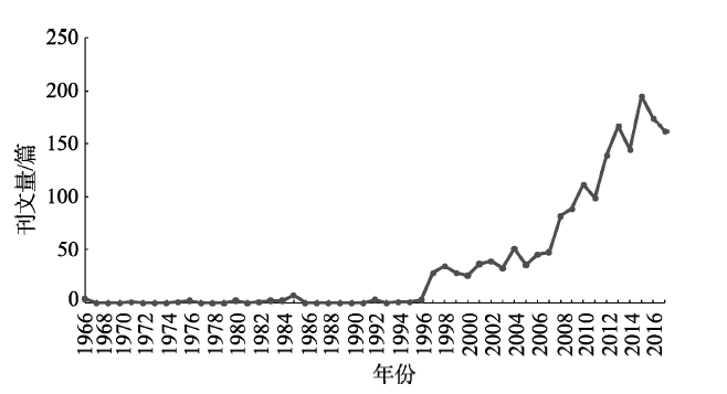
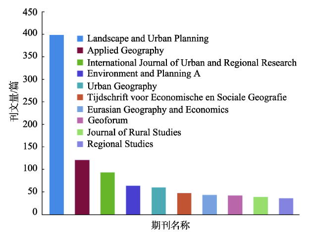

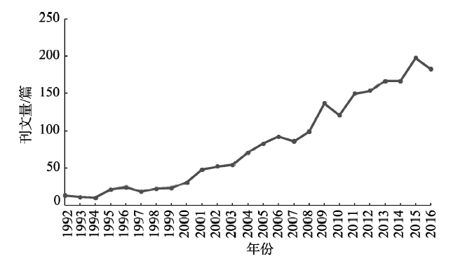

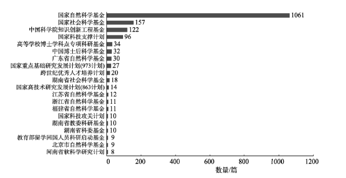

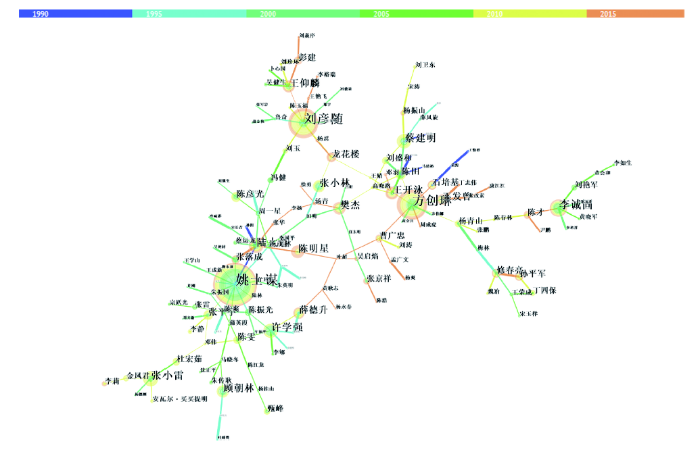

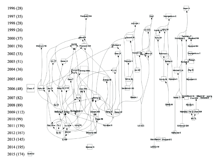
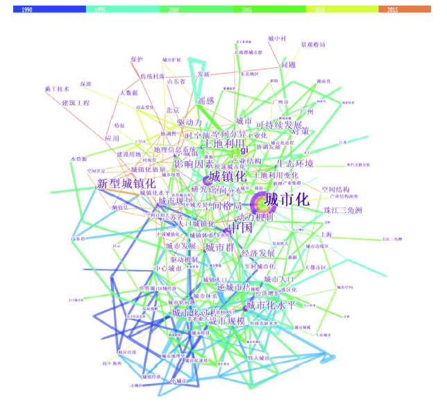