王平
中国科学院地理科学与资源研究所 陆地水循环及地表过程重点实验室,北京 100101
WANG Ping
收稿日期: 2017-09-29
修回日期: 2017-01-24
网络出版日期: 2018-02-28
版权声明: 2018 地理科学进展 《地理科学进展》杂志 版权所有
基金资助:
作者简介:
作者简介:王平(1979-),男,安徽肥西人,副研究员,硕导,主要从事流域水循环与地下水水文过程研究,E-mail: wangping@igsnrr.ac.cn。
展开
摘要
本文依托国家自然科学基金青年项目“河水温度对干旱区宽浅型河床渗透系数影响的定量研究”,并梳理了其他相关研究,总结了中国西北干旱区间歇性河流与含水层水量交换研究所面临的基础科学问题及当前所取得的研究进展。主要结论为:以宽浅型沙质河床为基本特征的西北干旱区内陆河流域下游河流,其河床每年经历数次干湿交替与冻融过程。受河水温度与河流水动力条件的影响,河床作为河流与含水层相互作用的重要界面,其渗透性能具有高度时空变异性,已成为河水与地下水水量交换研究的难点与热点。分析指出,在环境变化和当前交叉学科迅猛发展的背景下,以河流与含水层相互作用为核心的潜流带水文学发展面临新的机遇与挑战。
关键词:
Abstract
Incorporating the research results of the the National Natural Science Foundation supported project "Quantifying the effect of river water temperature on riverbed hydraulic conductivity of broad-shallow rivers in the arid area" (No. 41301025), this article summarizes the basic scientific issues and the current research progress in the field of water exchange between intermittent rivers and aquifers in arid areas of northwestern China. Riverbed at the lower reaches of rivers in the arid regions of northwestern China is shallow, wide, and sandy. Such riverbed experiences several dry/wet alternations and freezing-thawing process each year. Due to the influence of river temperature and river flow conditions, the riverbed as an important interface of river-aquifer systems exerts significant temporal and spatial variability, which has become a key issue in understanding surface water and groundwater exchange. Hyporheic zone hydrology, which focuses on river-aquifer interaction, is facing new opportunities and challenges under the current changing environment and rapidly developing interdisciplinary research.
Keywords:
河流与地下水作为陆地水循环过程的重要组成部分,两者间的相互作用在塑造地表形态的同时,促进潜流带的物质迁移和能量交换,并对河岸带生态系统产生影响(胡立堂等, 2007; Brunner et al, 2017; 朱金峰等, 2017)。近年来持续干旱、修建水库和无序取水等自然环境变化与人类活动对全球河流系统及地表水循环过程造成了严重影响。比如,包括河流在内的近9万平方公里地表水体在过去的32年间(1984-2015)逐渐消失(Pekel et al, 2016)。同时,超过30%的天然河流频繁断流,由常年性河流转变成间歇性河流,而且这一比例仍在增加(Tooth, 2000; Datry et al, 2014)。对于常年性河流系统而言,除了傍河水源地超采地下水所导致的河水与地下水脱节之外,河流与含水层之间通常处于饱和连接状态,即两者之间以饱和流方式进行水量交换(靳孟贵等, 2017)。相比之下,间歇性河流与含水层之间的水力联系则较为复杂,基本存在饱和连接(饱和流)、过渡连接(饱和流与非饱和流共存)和完全脱节(非饱和流)3种不同的水力联系状态,而且3种状态之间频繁转换且交替出现(Brunner et al, 2011)。近年来,间歇性河流脱节过程及其影响要素、以及由饱和连接至完全脱节过程中的河水入渗规律已成为河水与地下水交换研究的热点与难点。
对于饱和连接模式下的河流与含水层系统,河水与地下水之间的水量交换强度同河水位与地下水位差成线性关系(Hunt, 1999),并能依据饱和水流的达西定律来建立相应的解析模型(Hantush, 1965; Wang et al, 2015)。然而,正如Reid等(1990)所指出,一旦河水与地下水开始脱节,在河床与含水层之间会逐渐形成一个包气带。此时,应该结合非饱和土壤水分运动理论来描述下渗水分在包气带中的迁移过程,并需要考虑下渗水分到达地下水面的时间(Niswonger et al, 2005)。Fox等(2003)、Brunner等(2009)运用饱和-非饱和渗流理论先后研究了垂向一维状态下河流与含水层由饱和连接至完全脱节过程中的河水入渗速率变化。研究认为,在河水位及河床入渗性能不变的情况下,水力梯度随着地下水位的下降而不断增加,进而导致河水入渗速率逐渐增大,在河流与含水层完全脱节时达到最大,并趋于稳定。然而,Rivière等(2014)研究发现,在包气带开始形成的过渡连接阶段,当河床渗透性能远低于河床下方含水层渗透性能时,入渗速率在过渡连接初期达到最大,之后缓慢减小并趋于稳定。分析河床下方包气带的形成及其变化过程是深入理解河流脱节机理的关键,也是间歇性河流与含水层相互作用研究的难点,这方面研究仍有待加强。
如何有效识别河水与地下水是否脱节是河流与含水层相互作用研究的另一难点(Brunner et al, 2011)。Wang等(2016)认为,当自由水面的水平水力梯度为零,垂向水力梯度为1时,河水与地下水完全脱节。在地下水渗流理论分析的基础上,Brunner等(2009)基于一维垂向稳定流假设建立了判别河水与地下水脱节与否的数学表达式。然而,对于窄浅型河流与含水层系统,正如靳孟贵等(2017)所指出,由于水平流与垂直流共存,该判据并不适用。水平流的形成与脱节型河流两岸非饱和带的发育密切相关。当河流两岸非饱和带发展到一定阶段,河岸带非饱和介质毛细吸力足以引起河水在垂直入渗过程中产生水平方向的运移,即水平流(Xie et al, 2014; 靳孟贵等, 2017)。对具有淤塞层的河流脱节过程研究发现,当河水与地下水发生脱节之后,在淤塞层下方能够形成悬挂饱水带,其最大厚度约等于河水深(Wang et al, 2016)。Xie等(2014)研究发现,在一定条件下,未淤塞河流脱节之后同样可在河床下方发育有悬挂饱水带。围绕“河流-悬挂饱水带-非饱和带-地下水”系统的饱和与非饱和水流形成与转化研究,将有助于精准刻画间歇性河流与含水层之间的水分迁移过程。
作为河流与含水层相互作用的重要物理界面(Constantz, 2016),河床直接影响河水与地下水交换强度以及潜流带生物地球化学过程(Brunner et al, 2017; 杜尧等, 2017)。河床渗透系数(K)是反映河床沉积物导水能力的重要参数,其大小不仅取决于河床沉积物的性质,如粒度、成分、颗粒排列、充填状况、沉积结构等,同时与河水的物理性质,如容重、粘滞性具有密切的关系(薛禹群, 1997; Cuthbert et al, 2010)。受多种因素的影响,河床沉积物K值有一个较大的变化范围,从小于1×10⁻⁹ m/s到大于1×10-2 m/s不等(Calver, 2001)。不仅如此,河床渗透性能具有强烈的空间非均质性,并在时间上也呈现出一定的变异性(Chen, 2004; Tang et al, 2017)。河床沉积物所具有的这种时空变异特征,一方面,影响河流与含水层之间的转化关系;另一方面,造成难以准确定量河水与地下水交换量。当前,对河床渗透性能时空变异性及其影响因素的识别不仅是研究河水与地下水水量交换的关键与难点(束龙仓等, 2008; Rosenberry et al, 2009; Pozdniakov et al, 2016),也是河流与含水层相互作用研究的热点(Constantz, 2016; Brunner et al, 2017)。
河水与地下水交换的研究方法主要包括室内物理模拟实验、野外测定、数值模拟等(Yager, 1993; Landon et al, 2001; Kalbus et al, 2006; Rosenberry et al, 2008; Fleckenstein et al, 2010)。野外测定的方法很多,比如,河道流量测定法、抽水试验法、微水试验法、渗水试验法、离子示踪法等(Scanlon et al, 2002; Cook, 2015)。近年来,基于达西定律的各种形式原位渗流实验方法得到不断改进与完善,并在此基础上发展出原位测定河床渗透性能的一些新方法。如Chen(2000)所提出的原位竖管法已在河床沉积物渗透系数的野外测定上得到了较为广泛的应用(束龙仓等, 2002; 何志斌等, 2007; 宋进喜等, 2009)。圆盘渗流仪(seepage meter)也被广泛用于研究干旱区河流与含水层水量交换速率(Landon et al, 2001; Rosenberry, 2008)。
当前,随着温度示踪逐渐成为国际上研究河水与地下水交换的一种有效手段,利用温度变化信息定量研究河水与地下水交换,以及河水温度变化对河床沉积物K值的影响正逐渐成为一种新趋势(Ronan et al, 1998; Anderson, 2005; Hatch et al, 2006; Selker et al, 2006; Constantz, 2008; 吴志伟等, 2011; Halloran et al, 2016; Caissie et al, 2017)。通过记录河床的温度剖面,可观测到河水温度瞬变信号在河床内的传播过程,从而根据这个信号的形状和滞后时间估算向下的河水入渗速率(Constantz et al, 2003; Constantz, 2008; Lundquist et al, 2008; Roshan et al, 2012; Vogt et al, 2012)。在此基础上,结合河水与地下水水位及温度观测资料,即可计算获得河床沉积物K值及其随温度的变化关系(Hatch et al, 2006; Hatch et al, 2010; Hyun et al, 2011)。
近年来,在干旱与半干旱地区的常年或间歇性河流河床渗透系数研究方面,已有学者尝试利用温度感测器(固定在直径为4~5 cm的钻孔中)来记录河床剖面温度信号,从而实现对整个河床断面河床沉积物K值的估算(Vogt et al, 2010; Anibas et al, 2011; Gerecht et al, 2011; Anibas et al, 2016)。在计算方法上,采用对流与热传导计算模型对河床剖面的温度与水位观测数据进行分析,已成为定量确定河床入渗性能的一种重要手段(Anderson, 2005)。在河水及地下水热量与水量交换过程模拟,以及河床渗透系数时空变异性分析计算方面,美国农业部盐渍土实验室所开发的HYDRUS-1D水热耦合运移模型(Šimůnek, van Genuchten, 2008; Šimůnek, van Genuchten, Šejna, 2008; Šimůnek et al, 2016)和美国地质调查局所开发的变饱和孔隙介质水热运移模型VS2DH(Healy et al, 1996, 2012)已得到了广泛的应用与验证(Schmidt et al, 2007; Essaid et al, 2008; Anibas et al, 2009; Duque et al, 2010; Vandersteen et al, 2015; Halloran et al, 2016; Huang et al, 2016)。
随着地下水模型(比如,MODFLOW)的河道水流模块SFR1(Prudic et al, 2004)和SFR2(Niswonger et al, 2005)不断发展与完善,对河流与含水层系统的数值模拟已成为区域尺度上河水与地下水交换研究的重要手段(Yao, Zheng, Tian, 2015)。类似模拟研究的可靠性不仅依赖于一个相对完整的河水与地下水水位联合监测网(Wang et al, 2015),而且取决于对河流与含水层系统模型的正确概化以及对模型参数的准确估算(Yao, Zheng, Liu, 2015; Brunner et al, 2017)。从参数化的角度来看,上述所提及的野外研究方法,包括点尺度上的原位渗透实验以及关键河段尺度上的河道水量平衡实验,能为河水与地下水水量交换关键参数(比如,河床渗透系数)的确定提供依据。当前,随着测温技术的不断发展,点式测温、分布式测温、航空和航天遥感测温与水位、流量等传统水文观测相结合(Yao, Huang, et al, 2015),为地表水与地下水耦合模型的校正提供多源校正信息,保证从不同的时空尺度上研究河水与地下水相互作用的规律与强度(黄丽等, 2012; 马瑞等, 2013; 刘传琨等, 2014)。
受研究尺度、研究方法本身的局限性与不确定性等因素制约,单一研究方法所获得的计算结果代表性有限,而不同研究方法所得到的结果之间可能存在较大差异。因此,综合运用多种相互独立的技术方法,是提高河水与地下水水量交换研究结果可靠性的重要保障(McCallum et al, 2014)。
干旱区由于降水稀少,地表水资源贫乏,浅层地下水是人类生产与生活活动的基本保障,也是维持自然生态系统平衡的关键要素。对于干旱区内陆河下游地区来说,河流地表水是浅层地下水补给的重要来源(王平等, 2014)。当前,干旱区河流渗漏补给地下水的基础研究已成为河流与含水层相互作用研究的一项重要前沿课题(de Vries et al, 2002; Villeneuve et al, 2015),也是科学评价河岸带地下水资源,合理维持河流及河岸带生态系统功能(Jolly et al, 2008),以及进行水量调度系统论证的重要依据(程国栋等, 2014; Tian, Zheng, Zheng, et al, 2015; Wu B et al, 2015)。
干旱内陆河流域上、中、下游系于一脉,尽管流域内河水与地下水多次转换,但仍同属一个水资源系统(中国科学院地学部, 1996)。近年来,随着河流中上游水资源的过度开发利用,河流下游发生间歇性断流(Tian, Zheng, Wu, et al, 2015),导致河流与含水层系统之间形成了复杂的“饱和连接-过渡脱节-完全脱节”演化关系(Brunner et al, 2011),增加了河流与含水层之间水量交换研究的难度。此外,干旱区发育有数量众多的短小河流,且多为季节性河流。这些河流通常处于干涸状态,仅在暴雨期间形成河道径流,并通过砂质或砾石质河床快速渗漏补给地下水(Hoffmann et al, 2002; Morin et al, 2009; Noorduijn et al, 2014; Rau et al, 2017)。针对一次来水过程中水流湿润锋在河床下方非饱和带内的垂向运移过程,Dahan等(2008)发展了非饱和层监测系统(Vadose zone monitoring system, VMS),用于观测非饱和层中水流的渗漏过程。通过连续追踪非饱和带内的土壤含水量变化,分析计算水流的入渗速率。该方法已在干旱区间歇性河流一次洪水过程的河床入渗补给机理研究中取得了新的认识(Morin et al, 2009; Rimon et al, 2011)。尽管如此,受自然条件的限制,干旱区水文气象站点稀少,基础观测资料缺乏。因此,在上述地区开展间歇性河流与地下水交换研究仍然面临着极大的困难和挑战(Wheater et al, 2010)。
中国西北干旱区以温带大陆性气候为主,年内与昼夜温差大。由于河流水深较浅,河水与河床的温度受气温影响显著,尤其在严寒的冬季,宽浅型河流通常部分冻实或连底冻(图1)。与此同时,以塔里木河、黑河、石羊河为典型的中国西北内陆河流,其地表径流过程近年来受到了人为的调控(庞忠和, 2014; 王平等, 2014)。通常,每年在春秋两季向下游集中调水,而夏季河床经常处于干涸状态。河水温度年内及昼夜波动、河床季节性冻融与河道间歇性过水,作为西北干旱区下游河流水文的典型特征,势必导致河水物理性质、水动力条件及河床沉积物本身的改变,并进而影响河床渗透性能在时空尺度上的变化。然而,目前在对干旱区河流与地下水交换的定量研究方面,通常假定河床渗透性能是恒定的。由于不考虑环境要素对河床渗透性能的影响,野外试验所获取的河床渗透系数存在很大差异。比如,近年来不同研究人员对中国西北黑河下游额济纳东河河床渗透性能进行原位测试,其中Min等(2013)采用原位竖管法获得的河床渗透系数为12~28 m/d,而 Xi等(2015)利用Guelph入渗仪测定的河床渗透系数却相对较小(< 3 m/d)。除不同实验方法之间可能存在的测算误差外,两次测试期间环境要素(如水温、河水所携带的泥沙含量)的差异可能是导致所测算河床渗透系数差别的重要原因。
图1 黑河下游东居延海冻结冰面(左)与额济纳东河河岸地下冰层(右)
Fig.1 Icy lake of the East Juyan in the lower reach of the Heihe River (left) and underground ice at the riverbank of the East River in the Ejina (right)
在内陆河流域下游生态输水实践中,仍在探索一种更为优化的周期性输水模式,旨在持续恢复河岸带地下水位与河岸林植被(刘登峰等, 2014)。当前,在确定适宜输水期、输水持续时间及单次输水量的过程中,仍存在诸多科学问题尚待研究解决,其中包括:干旱区河流在间歇性过水与季节性冻融环境下,其水动力条件与河水温度是如何变化的,是否存在一定的规律?这些变化又将如何进一步影响河床渗透性能及河水与地下水之间的水量交换,它们之间是否存在某种具有物理机制的联系?
研究区黑河下游额济纳地处中国西北内陆腹地(图2),该区日照充足、干旱少雨、蒸发能力强、温差大、风沙多,为典型的大陆性干旱气候。据额济纳旗国家基本气象站1961-2015年的观测数据显示,这一地区多年平均降水量为35 mm,年均蒸发能力达到1500 mm左右(Wang et al, 2014; Du et al, 2016; Liu et al, 2016)。该地区多年平均气温为9.09 °C,其中月平均最高气温(7月)为27.05 °C,月平均最低气温(1月)为-11.23 °C,年内昼夜温差平均达15 °C。
图2 黑河下游研究区及野外试验场地位置图
Fig.2 Location of the lower reach of the Heihe River and the field experiment site
黑河是流入额济纳地区的唯一河流,在狼心山分为东、西2个支流,通常称之为额济纳东河与西河,并最终分别流向尾闾湖东、西居延海(图2)。20世纪50年代之后,随着黑河中游地区大规模的农业开发,下游地区的地表来水量不断减少,地下水位持续下降,导致绿洲区植被大面积死亡(Wang, Yu, et al, 2011);西居延海与东居延海也分别于1961和1992年干涸,引起沙尘天气增多、强度变大、影响范围变广。为恢复黑河下游日益退化的生态环境,管理部门自2000年开始实施生态输水工程,保证每年向黑河下游集中调水(Wang, Zhang, et al, 2011; Zhang et al, 2011)。
据狼心山水文站(图2)观测,2000-2015年期间向额济纳年均调水约5.5亿m3,其中额济纳东河输水量约占总调水量的70%。此外,额济纳东、西河过水时间主要集中在7-10月以及每年的12月至次年4月。在每年的4-6月,额济纳河流基本处于干涸状态,或仅有短暂的少量过水,总过水量一般不超过当年调水量的5%。7-8月虽然过水,但每次过水时间也非常短暂,因此,额济纳河在夏季以少水或无水为基本特征。与此同时,作为宽浅型河流,额济纳地表河流水深较浅(平均不超过1.5 m),受气温剧烈波动的影响,河水温度也呈现出显著的季节性变化特征。据2011-2012年对额济纳东河河床下方50 cm埋深的水温观测,河水/地下水日均温度在年内变化达到20°C(王平等, 2014)。由此可见,受河流间歇性输水和气温变化的双重影响,额济纳河的河床每年都至少经历1~2次干湿交替以及河水冻结与融化过程,具有中国西北干旱区内陆河下游水文过程的典型特征。
针对1.3所提出的科学问题,在国家自然科学基金青年项目《河水温度对干旱区宽浅型河床渗透系数影响的定量研究(项目批准号:41301025)》的资助下,选取位于额济纳东河中上段(距狼心山水文站约55 km处)的河床断面(图2)为研究对象,开展干旱区河床渗透性能时空变异性及河水与地下水水量交换的试验观测与模拟研究。本文是在青年项目研究成果的基础上,梳理了西北干旱区间歇性河流与含水层水量交换的研究进展,并展望了河流与含水层相互作用的发展趋势及其所面临的基础科学问题。
河床渗透系数定量研究方法总体上可分为实验室分析法、野外测定法、数值模拟法等(Scanlon et al, 2002; Cook, 2015)。实验室分析法主要是基于河床沉积物的颗粒级配曲线推求其渗透系数(Alyamani et al, 1993; Song et al, 2009),而数值模拟法则是通过参数识别的方法确定河床的渗透系数(Yager, 1993; Wang et al, 2015)。实验室分析法与数值模拟法都是通过间接的手段来获取河床渗透系数,而野外测定法则是通过原位实验直接获得河床沉积物K值,也是当前河床渗透系数测定最常用的方法之一。本次研究总体思路是以野外试验与观测为基础,通过分析计算确定河床沉积物K值,并分析不同环境下的K值差异性,揭示河床渗透性能时空变异性及其主要影响因素。研究方法包括典型断面河床剖面野外调查与采样、河床沉积物物理及水理性质室内分析、河床渗透性能原位测试、河流-含水层系统温度与水位同步连续自动观测、数值模拟与计算、数理统计分析等。
2.2.1 河流与含水层系统的水位与温度同步观测
假定河流与两侧地下水交换强度基本相同,由于其对称性,拟以河流中线为界在一侧布设河流与含水层系统的水位与温度同步观测,方案如图3所示。根据Wang等(2015)论证提出的河水与地下水监测方案,在垂直于河道方向上布设3眼地下水观测井(G1-G3)与1眼河水位监测井R1,用于分析河水与河岸带地下水之间的关系。在此基础上,考虑河流宽度及河床断面形态特征,自河流中线至河岸布设一定数量的河床温度与水位监测剖面(如图3所示的RB1-RB4)。然后,根据河床剖面垂向结构,在每个监测剖面自河床表层向下的不同深度内埋设温度自动记录仪,用于观测河床沉积物的温度变化。
图3 河流与含水层系统的水位与温度同步连续观测示意图
Fig.3 Schema of continuous in situ monitoring of water level and temperature for river-aquifer systems
2.2.2 河床渗透性能原位测试
根据非过水期河床剖面垂向结构特征调查结果,采用原位竖管法对河床沉积物渗透系数进行分层测定。Hvorslev(1951)较早提出了原位竖管法的理论计算依据,其试验方法如图4所示(Chen, 2000):将一定规格的测管竖直插入河床沉积物中,然后向竖管内连续注水。在管内注满水后,开始记录水头下降过程中不同时刻测管内水头位置,进而计算河床的垂向渗透系数。由于简单易行,该方法已成为当前河水与地下水交换定量研究中用来原位测试河床渗透性能的重要手段。
图4 原位竖管法测定河床沉积物渗透系数示意图。L为测管内河床沉积物的长度,H1和H2分别为t1和t2时刻所对应的测管内水头高度。
Fig.4 Schematic diagram showing the measurement of riverbed hydraulic conductivity using in-situ standpipe method. L is the thickness of the measured riverbed inside the standpipe, H1 and H2 are the water level inside the standpipe at the testing time t1 and t2, respectively.
原位测试以河流与含水层水位与温度同步监测断面为基准,从河岸一侧按等间距对河床渗透性能分层进行测定。在河流与含水层同步监测断面的上下游,根据河床形态分别增设一处类似的测试断面。考虑到温度、流量等水文气象要素对河床渗透性能的影响,原位测试在不同的季节和流量下进行,并且每次测试期间对河水温度、河水位、流速等要素进行测量与记录。单点测试完毕,原地采集河床沉积物样品,在室内采用筛分(>2-mm 粒级)与激光粒度仪(<2-mm 粒级)相结合的方法进行样品粒度分析。
2.2.3 河床沉积物水分运动参数分析
在河床干涸期,沿着河床渗透性能原位测试点采用容积为100 cm3环刀分层采集河床沉积物原状样品,室内测定样品的物理性质和水分运动参数,包括粒度分布、干容重、饱和含水率、渗透系数、水分特征曲线等。选取合适的含水量和吸力关系模型,如van-Genuchten (vG)模型(van Genuchten, 1980)、Brooks-Corey (BC)模型(Brooks et al, 1964)、Clapp-Hornberger (CH)模型(Clapp et al, 1978),对样品水分特征曲线进行拟合,获取模型计算所需要的水分运动参数。
2.2.4 河床渗透系数计算与分析
首先,分析不考虑温度影响的河床沉积物K值。对河床沉积物颗粒级配曲线进行分析,并根据经验公式计算其渗透系数K(Alyamani et al, 1993; Song et al, 2009)。然后,分析恒定温度下的河床沉积物K值。根据河床渗透性能原位测试结果,利用改进后的Hvorslev公式(Pozdniakov et al, 2016; Wang et al, 2017)计算一定河水温度下的河床沉积物K值。最后,分析计算变化温度下的河床沉积物K值。对河流与含水层系统的温度与水位同步观测原始数据进行预处理,插补因各种无法预测原因导致的观测数据短时段缺失,并生成可用的温度与水位原始步长序列。以水热耦合运移模型,如HYDRUS-1D(Šimůnek, van Genuchten, 2008)和VS2DH(Healy et al, 1996),为模拟分析平台,利用校正之后的河流与含水层温度与水位观测数据,结合所获取的河床断面形态资料与水热运移参数,计算获得不同河水温度下的河床沉积物K值数据序列。
通过对上述3种不同测算方法所获取的K值进行对比,采用数理统计分析方法量化河水温度对河床渗透性能及河水与地下水水量交换的影响。采用时间序列分析,进一步探讨河床渗透性能时空变异性及其对河床干湿交替与冻融过程的响应。
干旱区多发育冲积河床,河道形态及河床本身受水流冲刷作用强烈。当前,在西北干旱区内陆河下游人工输水过程中,单次流量可达到250~300 m3/s。在此流量下的一次洪水过程,能造成河岸与河床的侵蚀与堆积。如图5所示,经过几次洪水过程,干旱区河流河道内所布设的水位观测井被冲弯,而埋在河床下的温度观测线缆也被冲刷露出河床。可见,河床温度观测剖面的埋深是随河床冲刷与堆积过程而发生改变,增加了对温度观测数据分析的难度与不确定性。如何保证河床温度观测埋深的相对稳定是干旱区间歇性河流水热监测所面临的一个技术难题。
图5 被冲弯的河水观测井(左)和被冲刷而露出河床的温度观测线缆(右)
Fig.5 The bent observation well (left) and exposed temperature cable (right) by river flooding
2.4.1 河床渗透性能时间变异性的温度效应
在气温日较差与年较差显著的地区,温度是影响河床渗透性能的重要因素。一方面,河水冷热变化会引起水的密度和粘滞性变化,进而影响河床渗透性能(Doppler et al, 2007)。Constantz等(1994)对位于美国St. Kevin Gulch的160 m天然河段的研究发现,当河水温度从4°C升高到18°C,河床渗透系数约增加38%。在河床季节性温差达到20~25°C的黑河下游地区,因不考虑河水温度变化而导致的河水渗漏量被高估10%~15% (Wang et al, 2017)。特别是在冬季,当河床临近冻结状态(~1°C)时,河床的渗透能力显著降低,而这一因素在当前的河水与地下水交换定量研究中常被忽略。Lapham(1989)在研究不同类型河流的河水温度与河流渗漏量之间关系时,同样发现,河水温度是影响河床渗透系数变化的重要因素之一,尤其在昼夜及年内气温变化剧烈的干旱地区(Constantz, 2008; Mutiti et al, 2010)。另一方面,在季节冻融区,冬季河水冻结能够引起河水位抬升,从而改变河水与地下水之间的水力梯度,并进而影响河水与地下水之间的水量交换强度(Weber et al, 2013)。此外,在温度梯度驱动下,冻融作用引起土壤中水分向冻结锋面迁移,并在河岸形成冰层(Cheng, 1983; 周幼吾等, 2000; 徐斅祖等, 2001)。2012年3月底,我们在野外发现额济纳东河河岸沉积物30 cm深度处存在约10 cm厚的地下冰层(图1)。室内试验也证实,在底部充分供水的情况下,对土柱施加垂向温度梯度,能在土壤饱和带附近快速形成一定厚度的冰层。据此推测,在季节冻土区,当河岸附近地下水位浅、供水充分时,冬季可在冻结锋面处形成一定厚度的地下冰。这种地下冰的存在,在一定程度上降低了河水与地下水在侧向上的水量交换强度。因此,在冬季随着气温下降到0°C以下,在水深较浅的河床底部可能发生局部冻结,从而减少河床渗漏面积,降低河水与地下水的交换强度。
随着全球气候变暖的加剧,在多年冻土区,活动层的季节变动带来水文过程的显著变化,这种现象已受到国内外学者们的广泛关注(Walvoord et al, 2007; 王根绪等, 2007; Frey et al, 2009; Wang et al, 2009; Cheng et al, 2013; Turner et al, 2014; Gao et al, 2016; Hinkel et al, 2017; Liao et al, 2017)。但是,在季节冻土区,土壤的冻融对水文过程的影响机制和影响程度,仍有待探索。尤其在中国西北内陆河流域下游地区,河道输水主要集中在冬季,而河床及两岸沉积物以中细砂为主,导热性较好,冬季易发生冻结,影响河水与地下水之间的水量交换。在全球变暖背景下,研究河流季节性冻融条件下的水文效应,不仅可深化理解干旱区间歇性河流与含水层系统的相互作用过程,而且能为中国西北干旱区内陆河流域优化生态配水方案提供科学依据。
2.4.2 河床渗透性能空间变异性的河流水动力效应
在不同水动力条件下,河床表层细颗粒物质的冲刷与沉降过程是引起河床渗透性能显著变化的重要因素(Partington et al, 2017)。Wang等(2017)在黑河下游河道不同水动力条件下的原位竖管渗透实验结果表明,在河水清澈的低水位期,河床渗透性能好(~36 m/d)且稳定,而在河水浑浊的高水位期,河床渗透性能随实验时间的增加而衰减。与低水位期试验相比,高水位期河床渗透性能显著下降,河床渗透系数平均为6 m/d。据Wang等分析,在高水位期的原位竖管渗透实验过程中,河水所携带泥沙在测管内逐渐沉降,造成河床表层淤塞层不断加厚,从而导致河床渗透性能衰减。
为进一步证实河水所携带泥沙的自然沉降过程将导致河床渗透性能的不断减弱,我们于2017年8月29日在额济纳东河开展了清水与浊水环境下的原位竖管对比实验研究。如图6所示,首先向测管内注入清水,并记录竖管内水位的下降速率,直至实验结束。然后,向同一个竖管内注入浑浊的河水,并重复上述实验。对比实验的结果表明,清水条件下的水位降深随时间变化曲线ln(H0/H(t))~t呈现线性相关;而浊水条件下,ln(H0/H(t))~t曲线随着实验时间的推移,由开始的直线逐渐趋于平缓。对比实验证实了在静水条件下,浑浊河水所携带的泥沙不断沉降,引起河床表层淤塞,并导致河床渗透性能的减弱。
图6 原位竖管渗透实验对比研究,其中左图为清水实验,右图为浊水实验。
Fig.6 A comparative study of the in situ standpipe tests with clean (left) and muddy water (right)
需要指出的是,原位竖管实验结果所反映的是静水条件下的泥沙自然沉降过程,而河流在不同水动力条件下,河道内的细颗粒物质(如黏土、粉土等)的沉降与冲刷过程十分复杂(靳孟贵等, 2017),是引起河床渗透性能时空变异性的主要因素(冯斯美等, 2013)。Doble等(2012)发现,河道内的细粒物质在一次洪水事件中将发生冲刷和沉降两个过程。在洪水前期,水流快速冲刷河床,将河床表层的淤塞层(clogged layer)冲洗并带走,从而减少淤塞层的厚度,增加河床渗透性能(Simpson et al, 2012)。然而,在洪水末期,河水所携带的大量细小泥沙颗粒、碎屑物质以及悬浮物等又快速沉降到河床表层,再次引起河床淤塞,极大地降低河床的渗透性能(Gibson et al, 2011; Chen et al, 2013)。Wu G D等(2015)对山东省境内大汶河河床在洪水期前后的河床渗透性能进行原位测试分析,发现河床渗透性能在洪水之后整体下降,而且呈现出更强的空间异质性。
水位降深随时间变化曲线的显著非线性特征,是高水位期河流泥沙自然沉降过程导致河床表层淤塞的直接证据。尽管数学模型可较好地刻画静水条件下的泥沙沉降过程(Wang et al, 2017),但实际情况远比原位竖管渗透实验条件复杂。在河道过水过程中,受河床微地貌及水流紊流强度的影响,泥沙的冲刷与自然沉降交替(或同时)发生(Partington et al, 2017)。特别是由于河流水动力条件的差异,天然河流的淤塞层并不连续,而是呈现出强烈的空间变异性(靳孟贵等, 2017)。河床渗透性能的高度时空变异性决定了河流与含水层系统水量交换研究的复杂性与不确定性。
自130年前Boussinesq分析河流与连续冲积含水层作用规律以来(Winter, 1995),伴随实验技术和测量手段不断发展,河流与含水层相互作用研究已从当初单一的水文地质学问题发展到集水文地质学、水文地球化学、水文学、环境生态学、气象学等多学科为一体的交叉学科。迄今为止的研究从不同学科角度、不同时空尺度对河流与含水层之间的相互作用机制进行了探讨,提出了河水与地下水之间的转化模式,发展了河水与地下水交换的室内外试验方法与数值模拟技术。然而,由于河流与含水层系统相互作用是一个涉及到物理、化学、生物等多要素、多相流、多尺度的复杂生物地球化学过程,这一学科仍面临诸多亟待解决的基础科学问题。
首先,河床是河流与含水层相互作用的重要物理界面,控制着河流与含水层之间的水文及生物地球化学循环过程,而河床沉积物的物质组成与结构又受到潜流带水文和生物地球化学过程影响。目前,对河流冲积作用、生物化学作用以及冻融作用与河床沉积物时空变异性之间的互馈机制尚不清楚。因此,定量识别河床沉积物变化与潜流带水文和生物地球化学过程之间的互馈关系、探究该种互馈关系对河水与地下水交换的影响(靳孟贵等, 2017)、发展河流与含水层系统交互理论(刘传琨等, 2014)是未来研究的重要方向之一。
其次,当前河水与地下水交换研究主要包含以下3个空间尺度:一是点尺度上的河床渗透性能研究,二是剖面尺度上的河水与地下水交换速率研究,三是流域(河段)尺度上的水量平衡研究。尽管已有研究(Song et al, 2010; 宋进喜等, 2014)指出生物扰动能够改变河床沉积物结构,是影响潜流带水文过程的重要因素,但是对于孔隙尺度上的微生物过程和潜流带水文过程认识十分有限(杜尧等, 2017)。当前,自然环境变化和人类活动对河流生态系统产生了极大的影响,表现在干旱区河床干湿交替的频次在增加、河流与含水层系统温度场在发生改变。由于微生物对水分和温度的变化十分敏感,微生物如何响应变化环境、微生物过程如何影响潜流带水文过程,这将是孔隙尺度上潜流带水文学研究的重要内容。
最后,随着高精度传感与自动监测技术的发展,实现河流与含水层系统水文与生物地球化学过程的高精度、自动化监测将成为可能(杜尧等, 2017)。在获取包括气候、水文、地质、地貌、土壤、生物等自然要素在内的大量数据的同时,如何定量识别上述要素的时空变化过程(束龙仓等, 2003)、各要素间的互馈关系及其对变化环境与人类活动影响的响应,发展能精准刻画潜流带水文与生物地球化学过程的数值模型(Brunner et al, 2017),并解决模型时空尺度匹配、减少模型参数不确定性(Tian, Zheng, Zheng, et al, 2015),是我们面临的挑战。
致谢:感谢国家自然科学基金委员会地学部一处处长冷疏影研究员、中国科学院地理科学与资源研究所于静洁研究员、北京大学遥感与地理信息系统研究所范闻捷副教授在本文写作过程中给予的悉心指导、支持和帮助,感谢匿名审稿人专业且富有建设性的修改意见。本文在撰写过程中得到了中国科学院遗传与发育生物学研究所农业资源研究中心闵雷雷博士、中国科学院地理科学与资源研究所王田野和张学静两位研究生的帮助,在此一并表示衷心的感谢!
The authors have declared that no competing interests exist.
| [39] |
The mechanism of repeated-segregation for the formation of thick layered ground ice [J].https://doi.org/10.1016/0165-232X(83)90017-4 URL [本文引用: 1] 摘要
In this article, a mechanism of repeated-segregation for the formation of thick layered ground ice has been suggested. The mechanism consists of the following processes: (1) Moisture migration to the freezing front and ice lensing there as a result of upward freezing from permafrost. (2) Unequal law of migration of unfrozen water (the combined effect of the following processes: the upward migration of unfrozen water in a frozen active layer in the cold season; water migration and ice lensing in the frozen ground behind the freezing front during upward freezing; water migration and ice lensing in the still frozen ground beneath the thawing plane in the warm season). (3) Self-purification of ice. (4) Syngenetic growth of ground ice due to the addition of material onto the ground surface. (5) Annual repetition of the processes mentioned above. Thus, a new type of ground ice — repeated-segregation ice — is distinguished.
|
| [40] |
Permafrost and groundwater on the Qinghai-Tibet Plateau and in northeast China [J].https://doi.org/10.1007/s10040-012-0927-2 URL [本文引用: 1] 摘要
中国科学院机构知识库(中国科学院机构知识库网格(CAS IR GRID))以发展机构知识能力和知识管理能力为目标,快速实现对本机构知识资产的收集、长期保存、合理传播利用,积极建设对知识内容进行捕获、转化、传播、利用和审计的能力,逐步建设包括知识内容分析、关系分析和能力审计在内的知识服务能力,开展综合知识管理。
|
| [41] |
Empirical equations for some soil hydraulic properties [J].https://doi.org/10.1029/WR014i004p00601 URL [本文引用: 1] 摘要
The soil moisture characteristic may be modeled as a power curve combined with a short parabolic section near saturation to represent gradual air entry. This two-part function—together with a power function relating soil moisture and hydraulic conductivity—is used to derive a formula for the wetting front suction required by the Green-Ampt equation. Representative parameters for the moisture characteristic, the wetting front suction, and the sorptivity, a parameter in the infiltration equation derived by Philip (1957), are computed by using the desorption data of Holtan et al. (1968). Average values of the parameters, and associated standard deviations, are calculated for 11 soil textural classes. The results of this study indicate that the exponent of the moisture characteristic power curve can be predicted reasonably well from soil texture and that gradual air entry may have a considerable effect on a soil's wetting front suction.
|
| [42] |
Heat as a tracer to determine streambed water exchanges [J].https://doi.org/10.1029/2008WR006996 URL [本文引用: 3] 摘要
This work reviews the use of heat as a tracer of shallow groundwater movement and describes current temperature-based approaches for estimating streambed water exchanges. Four common hydrologic conditions in stream channels are graphically depicted with the expected underlying streambed thermal responses, and techniques are discussed for installing and monitoring temperature and stage equipment for a range of hydrological environments. These techniques are divided into direct-measurement techniques in streams and streambeds, groundwater techniques relying on traditional observation wells, and remote sensing and other large-scale advanced temperatureacquisition techniques. A review of relevant literature suggests researchers often graphically visualize temperature data to enhance conceptual models of heat and water flow in the near-stream environment and to determine site-specific approaches of data analysis. Common visualizations of stream and streambed temperature patterns include thermographs, temperature envelopes, and one-, two-, and three-dimensional temperature contour plots. Heat and water transport governing equations are presented for the case of transport in streambeds, followed by methods of streambed data analysis, including simple heat-pulse arrival time and heat-loss procedures, analytical and time series solutions, and heat and water transport simulation models. A series of applications of these methods are presented for a variety of stream settings ranging from arid to continental climates. Progressive successes to quantify both streambed fluxes and the spatial extent of streambeds indicate heat-tracing tools help define the streambed as a spatially distinct field (analogous to soil science), rather than simply the lower boundary in stream research or an amorphous zone beneath the stream channel.
|
| [43] |
Streambeds merit recognition as a scientific discipline [J].https://doi.org/10.1002/wat2.1119 URL [本文引用: 2] 摘要
Streambeds are generally viewed as simply sediments beneath streams, sediments topping alluvial aquifers, or sediments housing aquatic life, rather than as distinct geographic features comparable to soils and surficial geologic formations within watersheds. Streambeds should be viewed as distinct elements within watersheds, e.g., as akin to soils. In this presentation, streambeds are described as central features in watersheds, cycling water between the surface and underlying portions of the watershed. Regarding their kinship to soils, soils are often described as surficial sediments largely created by atmospheric weathering of underlying geologic parent material, and similarly, streambeds should be described as submerged sediments largely created by streamflow modification of underlying geologic parent material. Thus, streambeds are clearly overdue for recognition as their own scientific discipline along side other well-recognized disciplines within watersheds; however, slowing progress in this direction, the point is often made that hyporheic zones should be considered comparable to streambeds, but this is as misguided as equating unsaturated zones to soils. Streambeds and soils are physical geographic features of relatively constant volume, while hyporheic and unsaturated zones are hydrologic features of varying volume. Expanded upon in this presentation, 'Streambed Science' is proposed for this discipline, which will require both a well-designed protocol to physically characterize streambeds as well as development of streambed taxonomy, for suitable recognition as an independent discipline within watersheds.
|
| [44] |
Comparison of heat and bromide as ground water tracers near streams [J].https://doi.org/10.1111/j.1745-6584.2003.tb02403.x URL PMID: 13678119 [本文引用: 1] 摘要
Abstract Heat and bromide were compared as tracers for examining stream/ground water exchanges along the middle reaches of the Santa Clara River, California, during a 10-hour surface water sodium bromide injection test. Three cross sections that comprise six shallow (<1 m) piezometers were installed at the upper, middle, and lower sections of a 17 km long study reach, to monitor temperatures and bromide concentrations in the shallow ground water beneath the stream. A heat and ground water transport simulation model and a closely related solute and ground water transport simulation model were matched up for comparison of simulated and observed temperatures and bromide concentrations in the streambed. Vertical, one-dimensional simulations of sediment temperature were fitted to observed temperature results, to yield apparent streambed hydraulic conductivities in each cross section. The temperature-based hydraulic conductivities were assigned to a solute and ground water transport model to predict sediment bromide concentrations, during the sodium bromide injection test. Vertical, one-dimensional simulations of bromide concentrations in the sediments yielded a good match to the observed bromide concentrations, without adjustment of any model parameters except solute dispersivities. This indicates that, for the spatial and temporal scales examined on the Santa Clara River, the use of heat and bromide as tracers provide comparable information with respect to apparent hydraulic conductivities and fluxes for sediments near streams. In other settings, caution should be used due to differences in the nature of conservative (bromide) versus nonconservative (heat) tracers, particularly when preferential flowpaths are present.
|
| [45] |
Influence of diurnal variations in stream temperature on streamflow loss and groundwater recharge [J].https://doi.org/10.1029/94WR01968 URL [本文引用: 1] 摘要
We demonstrate that for losing reaches with significant diurnal variations in stream temperature, the effect of stream temperature on streambed seepage is a major factor contributing to reduced afternoon streamflows. An explanation is based on the effect of stream temperature on the hydraulic conductivity of the streambed, which can be expected to double in the 0 to 25 C temperature range. Results are presented for field experiments in which stream discharge and temperature were continuously measured for several days over losing reaches at St. Kevin Gulch, Colorado, and Tijeras Arroyo, New Mexico. At St. Kevin Gulch in July 1991, the diurnal stream temperature in the 160-m study reach ranged from about 4 to 18 C, discharges ranged from 10 to 18 L/s, and streamflow loss in the study reach ranged from 2.7 to 3.7 L/s. On the basis of measured stream temperature variations, the predicted change in conductivity was about 38%; the measured change in stream loss was about 26%, suggesting that streambed temperature varied less than the stream temperature. At Tijeras Arroyo in May 1992, diurnal stream temperature in the 655-m study reach ranged from about 10 to 25 C and discharge ranged from 25 to 55 L/s. Streamflow loss was converted to infiltration rates by factoring in the changing stream reach surface area and streamflow losses due to evaporation rates as measured in a hemispherical evaporation chamber. Infiltration rates ranged from about 0.7 to 2.0 m/d, depending on time and location. Based on measured stream temperature variations, the predicted change in conductivity was 29%; the measured change in infiltration was also about 27%. This suggests that high infiltration rates cause rapid convection of heat to the streambed. Evapotranspiration losses were estimated for the reach and adjacent flood plain within the arroyo. On the basis of these estimates, only about 5% of flow loss was consumed via stream evaporation and stream-side evapotranspiration, indicating that 95% of the loss within the study reach represented groundwater recharge.
|
| [46] |
Quantifying river gain and loss at regional scales [J].https://doi.org/10.1016/j.jhydrol.2015.10.052 URL [本文引用: 2] 摘要
River quifer exchange is highly spatially variable. For this reason, methods that estimate river gain or loss over small scales cannot be easily extrapolated to provide flux estimates over the tens to hundreds of kilometres of river length required for regional water management. Flux estimates at large scales can be provided by analysis of head gradients, differential flow gauging, river chemistry and groundwater chemistry. Hydraulic gradients allow estimation of exchange fluxes over scales of hundreds of metres or more, if piezometers located at similar distances from the river are available for measurement of aquifer heads. However, the difficulty of measuring hydraulic conductivity at this scale, and the need for piezometers at regular intervals along the river, mean that this method is likely to be inaccurate and difficult to apply in many catchments. Flow gauging has the potential to estimate fluxes over large scales, although it is difficult to apply in rivers where there is significant surface water pumping or where there are large numbers of tributaries. River chemistry can potentially provide estimates of exchange flux over distances of tens to hundreds of kilometres with a spatial resolution of hundreds of metres. Groundwater chemistry can provide estimates of loss rates at small to regional scales, depending upon the availability of piezometers for groundwater sampling, and the tracers that are used. Each method has its own advantages and limitations, and a combination of methods will usually provide most reliable flux estimates.
|
| [47] |
Impacts of river bed gas on the hydraulic and thermal dynamics of the hyporheic zone [J].https://doi.org/10.1016/j.advwatres.2010.09.014 URL [本文引用: 1] 摘要
Despite the presence of gas in river beds being a well known phenomenon, its potential feedbacks on the hydraulic and thermal dynamics of the hyporheic zone has not been widely studied. This paper explores hypotheses that the presence of accumulated gas impacts the hydraulic and thermal dynamics of a river bed due to changes in specific storage, hydraulic conductivity, effective porosity, and thermal diffusivity. The hypotheses are tested using data analysis and modelling for a study site on the urban River Tame, Birmingham, UK. Gas, predominantly attributed to microbial denitrification, was observed in the river bed up to around 14% by volume, and to at least 0.8 m depth below river bed. Numerical modelling indicates that, by altering the relative hydraulic conductivity distribution, the gas in the river bed leads to an increase of groundwater discharge from the river banks (relative to river bed) by a factor of approximately 2 during river low flow periods. The increased compressible storage of the gas phase in the river bed leads to an increase in the simulated volume of river water invading the river bed within the centre of the channel during storm events. The exchange volume can be more than 30% greater in comparison to that for water saturated conditions. Furthermore, the presence of gas also reduces the water-filled porosity, and so the possible depth of such invading flows may also increase markedly, by more than a factor of 2 in the observed case. Observed diurnal temperature variations within the gaseous river bed at 0.1 and 0.5 m depth are, respectively, around 1.5 and 6 times larger than those predicted for saturated sediments. Annual temperature fluctuations are seen to be enhanced by around 4 to 20% compared to literature values for saturated sediments. The presence of gas may thus alter the bulk thermal properties to such a degree that the use of heat tracer techniques becomes subject to a much greater degree of uncertainty. Although the likely magnitude of thermal and hydraulic changes due to the presence of gas for this site have been demonstrated, further research is needed into the origins of the gas and its spatial and temporal variability to enable quantification of the significance of these changes for chemical attenuation and hyporheic zone biology.
|
| [48] |
Dynamics of flood water infiltration and ground water recharge in hyperarid desert [J].https://doi.org/10.1111/j.1745-6584.2007.00414.x URL PMID: 18194313 [本文引用: 1] 摘要
Abstract A study on flood water infiltration and ground water recharge of a shallow alluvial aquifer was conducted in the hyperarid section of the Kuiseb River, Namibia. The study site was selected to represent a typical desert ephemeral river. An instrumental setup allowed, for the first time, continuous monitoring of infiltration during a flood event through the channel bed and the entire vadose zone. The monitoring system included flexible time domain reflectometry probes that were designed to measure the temporal variation in vadose zone water content and instruments to concurrently measure the levels of flood and ground water. A sequence of five individual floods was monitored during the rainy season in early summer 2006. These newly generated data served to elucidate the dynamics of flood water infiltration. Each flood initiated an infiltration event which was expressed in wetting of the vadose zone followed by a measurable rise in the water table. The data enabled a direct calculation of the infiltration fluxes by various independent methods. The floods varied in their stages, peaks, and initial water contents. However, all floods produced very similar flux rates, suggesting that the recharge rates are less affected by the flood stages but rather controlled by flow duration and available aquifer storage under it. Large floods flood the stream channel terraces and promote the larger transmission losses. These, however, make only a negligible contribution to the recharge of the ground water. It is the flood duration within the active streambed, which may increase with flood magnitude that is important to the recharge process.
|
| [49] |
Intermittent rivers: A challenge for freshwater ecology [J].https://doi.org/10.1093/biosci/bit027 URL [本文引用: 1] 摘要
ABSTRACT For many decades, river research has been focused on perennial rivers. Intermittent river research has a shorter history, and recent studies suggest that alternating dry and wet conditions alter virtually all biotic communities and biogeochemical processes in these rivers. Intermittent rivers constitute more than half of the length of the global river network and are increasing in number and length in response to climate change, land-use alteration, and water abstraction. Our views of the roles that rivers play in maintaining biodiversity and controlling material fluxes will change substantially when intermittent rivers are fully integrated into regional and global analyses. Concepts, questions, and methodologies from lotic, lentic, and terrestrial ecology need to be integrated and applied to intermittent rivers to increase our knowledge and effective management of these rivers.
|
| [50] |
Groundwater recharge: An overview of processes and challenges [J].https://doi.org/10.1007/s10040-001-0171-7 URL [本文引用: 1] 摘要
Since the mid-1980s, a relative explosion of groundwater-recharge studies has been reported in the literature. It is therefore relevant to assess what is now known and to offer further guidance to practitioners involved in water-resource development. The paper summarizes current understanding of recharge processes, identifies recurring recharge-evaluation problems, and reports on some recent advances in estimation techniques. Emphasis is accorded to (semi-)arid regions because the need for information is greatest in those areas groundwater is often the only water source, is vulnerable to contamination, and is prone to depletion. Few studies deal explicitly with groundwater recharge in temperate and humid zones, because recharge is normally included in regional groundwater investigations as one component of the water balance. The resolution of regional water-balance studies in (semi-)arid areas is, in contrast, often too low to quantify the limited recharge component with sufficient precision. Despite the numerous studies, determination of recharge fluxes in (semi-)arid regions remains fraught with uncertainty. Multiple tracer approaches probably offer the best potential for reliable results in local studies that require 'at-point' information. However, many investigations indicate that these approaches are not straightforward, because in some cases preferential flow contributes as much as 90% of the estimated total recharge. Tracer results (e.g. Cl , 3 H) must therefore be interpreted with care in areas with multi-modal flow in the vadose zone. Moreover, accurate estimation of total chloride deposition is essential, and tritium may be influenced by vapour transport at low flux rates. In addition, paleoclimatic and paleohydrological conditions may cause discrepancies between measured actual processes and calculated long-term averages. The frequently studied issues of localized recharge and spatial variability need not be a problem if concern is with regional estimates. The key for practitioners is the project objective, which dictates whether 'at-point' or area-/groundwater-based estimation methods are appropriate. Many indirect (wadi) recharge studies reported in the literature are site specific; the relationship between 'at point' hydraulic properties and channel-reach losses demands further investigation.
|
| [51] |
Groundwater recharge from overbank floods [J].https://doi.org/10.1029/2011WR011441 [本文引用: 1] 摘要
Overbank flood recharge is increasingly acknowledged as important for estimations of aquifer sustainable yield. The physics of this process in areas with shallow groundwater, however, is not well understood and typically is not included in river or groundwater models. Modeling of the overbank flood recharge process was undertaken using a fully coupled, surface-subsurface flow model to compare the volume of infiltration through a floodplain with varying surface sediment, aquifer, and flood parameters. The infiltration volume was found to increase with the conductance of the clogging layer (represented by a thin veneer of sediments across the floodplain and river bed), flood wave height, peak duration, and aquifer transmissivity and to decrease with increasing water table gradient (positive toward the river). The influence of the flood wave and aquifer hydraulic parameters was more pronounced in systems with sand or loam clogging layers. Irregularities in floodplain elevation had a large effect on infiltration volume. A dimensionless analysis of the flood recharge process identified the factors that limited flood infiltration for each of the modeled scenarios: the clogging layer conductance, unsaturated aquifer storage, or aquifer transmissivity. A dimensionless numberF* was used to predict the limiting factor in floodplain systems. An analytical equation was developed to estimate the infiltration volume for catchments where full numerical modeling is not warranted or applicable. Results from the analytical equation compared favorably with recharge modeled using a more complex numerical model.
|
| [52] |
Field evidence of a dynamic leakage coefficient for modelling river-aquifer interactions [J].https://doi.org/10.1016/j.jhydrol.2007.09.017 URL [本文引用: 1] 摘要
In groundwater flow modelling, the interaction between rivers and aquifers is usually modelled with spatially and temporally constant leakage coefficients. We used conventional model calibration techniques to investigate the time-varying river–aquifer interactions in the sandy gravel aquifer of the upper Limmat valley in Zurich (Switzerland). The aim of the study was to determine whether the leakage coefficients have to be treated as time-dependent in order to adequately model the dynamics of the groundwater flow. A transient horizontal two-dimensional groundwater flow model was established together with a one-dimensional hydraulic model for river flow, as well as a scheme calculating groundwater recharge and lateral inflow from meteorological data and a soil water balance model. The groundwater flow model was calibrated using hydraulic head data from May and June 2004 and July and August 2005. The verification period covered 1302years using hydraulic head data from 9002piezometers. The comparison of the model results with the measurements in the verification period revealed three phenomena concerning river–aquifer interaction which all showed up as systematic deviations between model and observations. (1) The major flood event in May 1999 had a significant and persistent influence on the river–aquifer interaction. In an impounded river section upstream of a weir, the infiltration of river water was enhanced by the flooding probably due to erosion processes. (2) Seasonal river water temperature fluctuations influenced the infiltration rate, due to the temperature dependence of hydraulic conductivity of the river bed. (3) Depending on geometry and hydraulic characteristics of the riverbanks the leakage coefficient can be a function of the river stage. With higher water levels, additional areas can contribute to the infiltration of river water. Therefore, in modelling groundwater flow with strong river–aquifer interactions, it can become necessary to consider dynamic leakage coefficients and to recalibrate periodically.
|
| [53] |
2016. Reference evapotranspiration changes: Sensitivities to and contributions of meteorological factors in the Heihe River basin of northwestern China (1961-2014) [J].https://doi.org/10.1155/2016/4143580 URL [本文引用: 1] 摘要
This paper investigates reference evapotranspiration (ET0) changes, sensitivities to and contributions of meteorological factors in the Heihe River Basin (arid and inland region). Results show that annual ET0 over the whole basin has increasing trend (2.0165mm·1065yr612) and there are significant increasing spatial variations from the upper (75365mm65yr611) to the lower (155365mm65yr611) regions. Sensitivity analysis indicates that relative humidity is the most sensitive factor for seasonal and annual ET0 change, and the influence is negative. The sensitivity of minimum temperature is the weakest and negative. Contribution analysis shows that the main contributors to ET0 changes are aerodynamic factors rather than radiative factors. This study could be helpful to understand the response of ecoenvironment to the meteorological factors changes in the Heihe River Basin.
|
| [54] |
Investigating river-aquifer relations using water temperature in an anthropized environment (Motril-Salobreña aquifer) [J].https://doi.org/10.1016/j.jhydrol.2009.11.032 URL [本文引用: 1] 摘要
Changes in groundwater temperatures recorded between 15 and 40 m deep are detected during the periods of higher river discharge. Temperature logs envelopes reveal areas of infiltration dominance and areas where vertical upward flows are present. For the quantification of the recharge volume, a model was constructed with VS2DHI. The study of the temperature measurements suggests an upper zone of groundwater temperature variability related with the direct infiltration from the river. Also there is a deeper zone where temperature changes are related with the heat transport associated to the main groundwater flow in the aquifer. With the evaluation of the temperature data by different means, the conceptual three-dimensional flow model has been strongly improved establishing the basis for a future 3D modelling.
|
| [55] |
Using heat to characterize streambed water flux variability in four stream reaches [J].https://doi.org/10.2134/jeq2006.0448 URL PMID: 18453424 [本文引用: 1] 摘要
Abstract Estimates of streambed water flux are needed for the interpretation of streambed chemistry and reactions. Continuous temperature and head monitoring in stream reaches within four agricultural watersheds (Leary Weber Ditch, IN; Maple Creek, NE; DR2 Drain, WA; and Merced River, CA) allowed heat to be used as a tracer to study the temporal and spatial variability of fluxes through the streambed. Synoptic methods (seepage meter and differential discharge measurements) were compared with estimates obtained by using heat as a tracer. Water flux was estimated by modeling one-dimensional vertical flow of water and heat using the model VS2DH. Flux was influenced by physical heterogeneity of the stream channel and temporal variability in stream and ground-water levels. During most of the study period (April-December 2004), flux was upward through the streambeds. At the IN, NE, and CA sites, high-stage events resulted in rapid reversal of flow direction inducing short-term surface-water flow into the streambed. During late summer at the IN site, regional ground-water levels dropped, leading to surface-water loss to ground water that resulted in drying of the ditch. Synoptic measurements of flux generally supported the model flux estimates. Water flow through the streambed was roughly an order of magnitude larger in the humid basins (IN and NE) than in the arid basins (WA and CA). Downward flux, in response to sudden high streamflows, and seasonal variability in flux was most pronounced in the humid basins and in high conductivity zones in the streambed.
|
| [56] |
Groundwater-surface water interactions: New methods and models to improve understanding of processes and dynamics [J].https://doi.org/10.1016/j.advwatres.2010.09.011 URL [本文引用: 1] 摘要
Interest in groundwater (GW)-surface water (SW) interactions has grown steadily over the last two decades. New regulations such as the EU Water Framework Directive (WFD) now call for a sustainable management of coupled ground- and surface water resources and linked ecosystems. Embracing this mandate requires new interdisciplinary research on GW-SW systems that addresses the linkages between hydrology, biogeochemistry and ecology at nested scales and specifically accounts for small-scale spatial and temporal patterns of GW-SW exchange. Methods to assess these patterns such as the use of natural tracers (e.g. heat) and integrated surface-subsurface numerical models have been refined and enhanced significantly in recent years and have improved our understanding of processes and dynamics. Numerical models are increasingly used to explore hypotheses and to develop new conceptual models of GW-SW interactions. New technologies like distributed temperature sensing (DTS) allow an assessment of process dynamics at unprecedented spatial and temporal resolution. These developments are reflected in the contributions to this Special Issue on GW-SW interactions. However, challenges remain in transferring process understanding across scales.
|
| [1] |
黑河流域生态—水文过程集成研究进展 [J].https://doi.org/10.11867/j.issn.1001-8166.2014.04.0431 Magsci [本文引用: 1] 摘要
<p>国家自然科学基金重大研究计划“黑河流域生态—水文过程集成研究”(简称黑河计划)贯穿地球系统科学的思维, 针对我国内陆河地区严峻的水—生态问题, 探索流域尺度提高水效益的理论和方法。计划执行4年来, 建立了遥感—监测—实验一体的流域生态水文观测系统及其相应的数据平台; 初步揭示了流域冰川、森林、绿洲等重要生态水文过程耦合机理, 认识了流域一级生态水文单元的水系统特征, 奠定了流域水循环、水平衡的科学基础; 计算了黑河下游生态需水量, 为黑河流域水资源优化管理厘定了重要的约束条件。今后几年将在高精度气、水、生、经时空数据的支持下, 耦合与集成流域综合模型, 保证我国流域科学能在世界前沿占一席之地。</p>
Advances in synthetic research on the eco-hydrological process of the Heihe River Basin [J].https://doi.org/10.11867/j.issn.1001-8166.2014.04.0431 Magsci [本文引用: 1] 摘要
<p>国家自然科学基金重大研究计划“黑河流域生态—水文过程集成研究”(简称黑河计划)贯穿地球系统科学的思维, 针对我国内陆河地区严峻的水—生态问题, 探索流域尺度提高水效益的理论和方法。计划执行4年来, 建立了遥感—监测—实验一体的流域生态水文观测系统及其相应的数据平台; 初步揭示了流域冰川、森林、绿洲等重要生态水文过程耦合机理, 认识了流域一级生态水文单元的水系统特征, 奠定了流域水循环、水平衡的科学基础; 计算了黑河下游生态需水量, 为黑河流域水资源优化管理厘定了重要的约束条件。今后几年将在高精度气、水、生、经时空数据的支持下, 耦合与集成流域综合模型, 保证我国流域科学能在世界前沿占一席之地。</p>
|
| [57] |
Unsaturated hyporheic zone flow in stream/aquifer conjunctive systems [J].https://doi.org/10.1016/S0309-1708(03)00087-3 URL [本文引用: 1] 摘要
Saturated flow is typically assumed for seepage from a stream underlain by an alluvial aquifer. However, if the water table falls a sufficient distance below a semipervious streambed, the head losses in this less conductive layer will cause the region beneath the stream, or hyporheic zone, to become unsaturated. Hyporheic zone flow is defined loosely in this research as the flow that occurs underneath the streambed. Unsaturated flow transforms streams from constant head boundaries to constant flux boundaries, impacting the biogeochemistry in the hyporheic zone. The objective of this paper is to discuss the development and implications of unsaturated flow beneath the streambed. Conditions under which saturated or unsaturated flow occurs and the characteristics of each flow regime are discussed. Next, the effect of unsaturated flow is illustrated for the case of stream leakage induced by a well pumping from an aquifer that is hydraulically interacting with a partially penetrating stream. Prior analytical solutions for alluvial well depletions fail to model unsaturated flow between the streambed and water table. An approximating solution is proposed to estimate aquifer drawdown and stream depletion under saturated/unsaturated hyporheic zone flow conditions.
|
| [58] |
Impacts of permafrost degradation on arctic river biogeochemistry [J].https://doi.org/10.1002/hyp.7196 URL [本文引用: 1] 摘要
Over the next century, near-surface permafrost across the circumpolar Arctic is expected to degrade significantly, particularly for land areas south of 70 N. This is likely to cause widespread impacts on arctic hydrology, ecology, and trace gas emissions. Here, we present a review of recent studies investigating linkages between permafrost dynamics and river biogeochemistry in the Arctic, including consideration of likely impacts that warming-induced changes in permafrost may be having (or will have in the future) on the delivery of organic matter, inorganic nutrients, and major ions to the Arctic Ocean. These interacting processes can be highly complex and undoubtedly exhibit spatial and temporal variabilities associated with current permafrost conditions, sensitivity to permafrost thaw, mode of permafrost degradation (overall permafrost thaw, active layer deepening, and/or thermokarst processes), and environmental characteristics of watersheds (e.g. land cover, soil type, and topography). One of the most profound consequences of permafrost thaw projected for the future is that the arctic terrestrial freshwater system is likely to experience a transition from a surface water-dominated system to a groundwater-dominated system. Along with many other cascading impacts from this transition, mineral-rich groundwater may become an important contributor to streamflow, in addition to the currently dominant contribution from mineral-poor surface water. Most studies observe or predict an increase in major ion, phosphate, and silicate export with this shift towards greater groundwater contributions. However, we see conflicting accounts of whether the delivery of inorganic nitrogen and organic matter will increase or decrease with warming and permafrost thaw. It is important to note that uncertainties in the predictions of the total flux of biogeochemical constituents are tightly linked to future uncertainties in discharge of rivers. Nonetheless, it is clear that over the next century there will be important shifts in the river transport of organic matter, inorganic nutrients, and major ions, which may in turn have critical implications for primary production and carbon cycling on arctic shelves and in the Arctic Ocean basin interior. Copyright 2008 John Wiley & Sons, Ltd.
|
| [59] |
Reduced winter runoff in a mountainous permafrost region in the northern Tibetan Plateau [J].https://doi.org/10.1016/j.coldregions.2016.03.007 URL [本文引用: 1] 摘要
The degradation of mountain permafrost under climate warming may alter the runoff regime of high mountainous catchments. In this study, we evaluated the influence of permafrost on the hydrological regime using hydrological signals in the Yeniugou Basin located in a mountainous permafrost region in the Qilian Mountains of the northern Tibetan Plateau (TP). The effect of permafrost degradation on the hydrological response was assessed based on 28 years of runoff and meteorological data. The results indicated that the investigated region exhibited a large increase in annual surface ground temperature from 1979 to 2006, with almost unchanged precipitation and evaporation potential. The winter runoff levels exhibited a significant decreasing linear trend, whereas the annual runoff and runoff in other seasons did not show any distinct linear trends. According to a comprehensive analysis of the relationships between winter runoff and meteorological factors, the ratio of maximum (Q max ) and minimum (Q min ) discharge, the recession coefficient and baseflow separation, and the reduced winter runoff were significantly correlated with thawing of permafrost. However, due to a time-lag response of climate forcing to permafrost thawing, some of these changes are undetectable over a short period. This study provides preliminary data on cold region hydrology and its response to climate change.
|
| [60] |
Dynamics of hyporheic flow and heat transport across a bed-to-bank continuum in a large regulated river [J].https://doi.org/10.1029/2010WR009794 URL [本文引用: 1] 摘要
The lower Colorado River (LCR) near Austin, Texas is heavily regulated for hydropower generation. Daily water releases from a dam located 23 km upstream of our study site in the LCR caused the stage to fluctuate by more than 1.5 m about a mean depth of 1.3 m. As a result, the river switches from gaining to losing over a dam storage-release cycle, driving exchange between river water and groundwater. We assessed the hydrologic impacts of this by simultaneous temperature and head monitoring across a bed-to-bank transect. River-groundwater exchange flux is largest close to the bank and decreases away from the bank. Correspondingly, both the depth of the hyporheic zone and the exchange time are largest close to the bank. Adjacent to the bank, the streambed head response is hysteretic, with the hysteresis disappearing with distance from the bank, indicating that transient bank storage affects the magnitude and direction of vertical exchange close to the bank. Pronounced changes in streambed temperature are observed down to a meter. When the river stage is high, which coincides with when the river is coldest, downward advection of heat from a previous cycles' warm-water pulse warms the streambed. When the river is at its lowest stage but warmest temperature, upwelling groundwater cools the streambed. Future research should consider and focus on a more thorough understanding of the impacts of dam regulation on the hydrologic, thermal, biogeochemical, and ecologic dynamics of rivers and their hyporheic and riparian zones.
|
| [2] |
潜流带水文—生物地球化学: 原理、方法及其生态意义 [J].https://doi.org/10.3799/dqkx.2017.054 URL [本文引用: 3] 摘要
精确量化潜流带水文交换和生物地球化学反应一直是一个挑战,潜流带水文-生物地球化学研究的核心任务是将小尺度上的水文通量及生物地球化学反应动力学与更大尺度上它们对河流水质和生态的累积效应关联起来.基于潜流带水文-生物地球化学耦合原理,系统综述了渗流仪测量、测压管测量、示踪剂注射试验、温度示踪等潜流带水文学研究方法以及野外示踪试验、室内培养试验等生物地球化学研究方法,针对性地评述了潜流带水文-生物地球化学过程在更大尺度上的累积效应及其对河流生态系统的重要意义,并指出未来的研究将从潜流带研究技术方法的先进化、水文地貌理论与模型的深入化和潜流带生物地球化学过程的尺度化等方面持续地发展.
Hydro-biogeochemistry of hyporheic zone: Principles, methods and ecological significance [J].https://doi.org/10.3799/dqkx.2017.054 URL [本文引用: 3] 摘要
精确量化潜流带水文交换和生物地球化学反应一直是一个挑战,潜流带水文-生物地球化学研究的核心任务是将小尺度上的水文通量及生物地球化学反应动力学与更大尺度上它们对河流水质和生态的累积效应关联起来.基于潜流带水文-生物地球化学耦合原理,系统综述了渗流仪测量、测压管测量、示踪剂注射试验、温度示踪等潜流带水文学研究方法以及野外示踪试验、室内培养试验等生物地球化学研究方法,针对性地评述了潜流带水文-生物地球化学过程在更大尺度上的累积效应及其对河流生态系统的重要意义,并指出未来的研究将从潜流带研究技术方法的先进化、水文地貌理论与模型的深入化和潜流带生物地球化学过程的尺度化等方面持续地发展.
|
| [61] |
Visualization and analysis of temporal trends of sand infiltration into a gravel bed [J].https://doi.org/10.1029/2011WR010486 URL [本文引用: 1] 摘要
Sand infiltration into gravel frameworks affects a wide range of ecological, geomorphic, and engineering processes. Four flume experiments were conducted with tracer materials to examine how a sand pulse infiltrates into a gravel bed. These experiments were primarily designed to test two hypotheses: (1) that vertical gradational trends of interstitial deposits are due to differential transport of finer sand in suspended load (hydraulic sorting) and (2) that the formation of a bridge layer (a thin layer of infiltrated sediments that become lodged in shallow pore throats) precludes subsequent infiltration into a gravel framework. Several sand colors were sequentially introduced into a flume containing a gravel substrate. After the experiments were conducted bed cores were collected and separated into vertical layers including surface layers composed primarily of sand that was transporting as bed load before the experiment was terminated and interstitial deposits in the gravel framework. Sand from each layer was sieved and measured. The color distribution of each grain class of each vertical layer of each core was measured to determine the temporal provenance of the interstitial deposits. Results supported the occurrence of hydraulic sorting. Older (finer) sand particles were disproportionately prevalent in interstitial deposits when compared to bed load samples. The experiments did not support the second hypothesis. Substantial secondary infiltration occurred after the initial formation of a bridge layer. More secondary infiltration was measured for systems with higher d/dratios and when bed shear was sufficient to mobilize the gravel.
|
| [62] |
Heat as a tracer to quantify processes and properties in the vadose zone: A review [J].https://doi.org/10.1016/j.earscirev.2016.06.009 URL [本文引用: 2] 摘要
Soil moisture and temperature are some of the most important controls for a wide variety of geochemical and ecological processes in the vadose zone (VZ). Soil moisture is highly variable both spatially and temporally. The development of methods to measure it on various scales has been the subject of much activity. Recently, geoscientists have been increasingly interested in measuring temperature as a proxy for hydrologic properties and parameters, including soil moisture. Here, we discuss the motivation, primary concepts, equipment, and fundamental thermal and hydraulic models related to heat and water transport in variably saturated porous media. A large variety of methods for heat tracing, including both passive and active-heating methodologies, are detailed. Heat tracing methods offer the capacity to measure soil moisture on a scale from ~ 1 cm up to several km using temperature, a parameter whose measurement in VZ studies is often required anyway due to its effect on many subsurface processes. Furthermore, heat-tracing methods are not affected by high salinity pore water that can limit electromagnetic soil moisture methods. We also review coupled thermo-hydro VZ modelling software and VZ thermal regime studies and identify several knowledge gaps. With the intention to serve as an introduction to VZ heat-tracing, this review consolidates recent advances and outlines potential themes for future research.
|
| [3] |
河流潜流带渗透系数变化研究进展 [J].
介绍了河流潜流带的含义,即是河水与地下水发生物质能量交换的区域,其水力联系和交换水量大小受河床沉积物渗透系数的影响。对近年来国内外学者对河床潜流带渗透系数变化进行了大量研究。由于特殊的环境与水文地质条件,潜流带渗透系数的大小不仅取决于沉积物孔隙大小和孔隙的连通性,而且与生物扰动、河流流水等作用紧密相关:洪水带来的细小颗粒引起河床表面沉积物孔隙淤塞,致使渗透系数减小,但在洪水退后,潜流带的水文交换和生物扰动能破坏淤塞层,从而引起反淤塞作用,造成河床渗透系数增大。因此,淤塞-反淤塞作用改变着河床的渗透性能。最后,指出存在的问题今后的研究方向。
An overview of the effects of hyporheic processes on the streambed hydraulic conductivity in the hyporheic zone of a river [J].
介绍了河流潜流带的含义,即是河水与地下水发生物质能量交换的区域,其水力联系和交换水量大小受河床沉积物渗透系数的影响。对近年来国内外学者对河床潜流带渗透系数变化进行了大量研究。由于特殊的环境与水文地质条件,潜流带渗透系数的大小不仅取决于沉积物孔隙大小和孔隙的连通性,而且与生物扰动、河流流水等作用紧密相关:洪水带来的细小颗粒引起河床表面沉积物孔隙淤塞,致使渗透系数减小,但在洪水退后,潜流带的水文交换和生物扰动能破坏淤塞层,从而引起反淤塞作用,造成河床渗透系数增大。因此,淤塞-反淤塞作用改变着河床的渗透性能。最后,指出存在的问题今后的研究方向。
|
| [63] |
Wells near streams with semipervious beds [J].https://doi.org/10.1029/JZ070i012p02829 URL [本文引用: 1] 摘要
Currently used formulas for the drawdown distribution and the rate and total volume of river depletion resulting from wells pumping nearby are based primarily on the assumption that the bed of the stream is as permeable as the aquifer it completely cuts through. These formulas have been empirically modified to be approximately applicable when the stream bed is semipervious and is partially penetrating the aquifer. This modification is based on the assumption that the resistance to flow due to the partial penetration and the semiperviousness of the stream bed can be reasonably replaced by its equivalent owing to flow through a horizontal additional stretch of the main aquifer. This additional length is determined empirically by using pumping test data in conjunction with the drawdown equation for the substitute system. In the present study, the approach to the problem is to replace the resistance to flow due to the semiperviousness of the bed of the stream by an equivalent resistance due to a horizontal flow through a semipervious layer of insignificant storage capacity which is lying between the aquifer and the channel of the stream. The conjecture is that this approach is closer to reality and, consequently, yields flow formulas that reproduce the flow conditions in the actual system more closely. Except for the unsteady drawdown equation, this approach has led to flow equations that are as easy as their counterparts now in use. Tabulation of the function involved in the unsteady drawdown equation is not difficult, and, once completed, the equation becomes as easy to use as any other simple formula. Quantitative comparison between results of the old and the new approaches are presented graphically. A procedure using the steady-state drawdown equation is outlined for obtaining the transmissivity of the aquifer, the effective distance to the stream, and the retardation coefficient of the channel lining.
|
| [64] |
Quantifying surface water-groundwater interactions using time series analysis of streambed thermal records: Method development [J].https://doi.org/10.1029/2005WR004787 URL [本文引用: 2] 摘要
We present a method for determining streambed seepage rates using time series thermal data. The new method is based on quantifying changes in phase and amplitude of temperature variations between pairs of subsurface sensors. For a reasonable range of streambed thermal properties and sensor spacings the time series method should allow reliable estimation of seepage rates for a range of at least ??10 m d-1 (??1.2 ?? 10-2 m s-1), with amplitude variations being most sensitive at low flow rates and phase variations retaining sensitivity out to much higher rates. Compared to forward modeling, the new method requires less observational data and less setup and data handling and is faster, particularly when interpreting many long data sets. The time series method is insensitive to streambed scour and sedimentation, which allows for application under a wide range of flow conditions and allows time series estimation of variable streambed hydraulic conductivity. This new approach should facilitate wider use of thermal methods and improve understanding of the complex spatial and temporal dynamics of surface water-groundwater interactions. Copyright 2006 by the American Geophysical Union.
|
| [4] |
河床水力传导度及其各向异性的测定 [J].https://doi.org/10.3321/j.issn:1001-6791.2007.03.007 URL Magsci [本文引用: 1] 摘要
采用直接测定法观测了黑河中游段河床水力传导度及其各向异性,结果表明:河床水力传导度不仅存在较强的各向异性,而且存在空间尺度上的变异性.河床中心位置在垂直、水平和θ=30°方向的平均水力传导度分别为0.45、22.49和1.71 m/d,河床边分别为5.95、29.69、16.80 m/d.在同一测点,水力传导度随着与水平方向的夹角增大呈幂函数曲线下降.试验结果表明河床边是河水的主要渗漏区,并且以侧渗为主.
Measurement of streambed hydraulic conductivity and anisotropy analysis [J].https://doi.org/10.3321/j.issn:1001-6791.2007.03.007 URL Magsci [本文引用: 1] 摘要
采用直接测定法观测了黑河中游段河床水力传导度及其各向异性,结果表明:河床水力传导度不仅存在较强的各向异性,而且存在空间尺度上的变异性.河床中心位置在垂直、水平和θ=30°方向的平均水力传导度分别为0.45、22.49和1.71 m/d,河床边分别为5.95、29.69、16.80 m/d.在同一测点,水力传导度随着与水平方向的夹角增大呈幂函数曲线下降.试验结果表明河床边是河水的主要渗漏区,并且以侧渗为主.
|
| [65] |
Spatial and temporal variations in streambed hydraulic conductivity quantified with time-series thermal methods [J].https://doi.org/10.1016/j.jhydrol.2010.05.046 URL PMID: 15373905 [本文引用: 1] 摘要
We gauged and instrumented an 11.42-km long experimental reach of the Pajaro River, central coastal California, to determine rates of streambed seepage (loss and hyporheic exchange) using reach averaged and point specific methods. We used these data to assess changes in streambed hydraulic conductivity with time, as a function of channel discharge and associated changes in sediment scour and deposition. Discharge loss along the experimental reach was generally 0.1–0.3 m 3 s 611 when channel discharge was 812 m 3 s 611, with most of the loss occurring along the lower part of the experimental reach. Point specific seepage rates, determined using time-series analysis of streambed thermal records, indicate seepage rates as great as 611.4 m day 611 (downward into the streambed). Seepage rates varied spatially and with time, with greater seepage occurring along the lower part of the reach and during the summer and fall. Seepage rate and hydraulic gradient data show that streambed hydraulic conductivity was 10 616–10 614 m s 611 along the experimental reach, with lower conductivity determined later in the dry season, as sediment was deposited on the streambed during low flow conditions. These results suggest that models of surface water–ground water interactions may benefit from inclusion of relations between stream discharge, sediment load, and streambed hydraulic properties.
|
| [66] |
VS2DI: Model use, calibration, and validation [J].https://doi.org/10.13031/2013.42238 URL [本文引用: 1] 摘要
VS2DI is a software package for simulating water, solute, and heat transport through soils or other porous media under conditions of variable saturation. The package contains a graphical preprocessor for constructing simulations, a postprocessor for displaying simulation results, and numerical models that solve for flow and solute transport (VS2DT) and flow and heat transport (VS2DH). Flow is described by the Richards equation, and solute and heat transport are described by advection-dispersion equations; the finite-difference method is used to solve these equations. Problems can be simulated in one, two, or three (assuming radial symmetry) dimensions. This article provides an overview of calibration techniques that have been used with VS2DI; included is a detailed description of calibration procedures used in simulating the interaction between groundwater and a stream fed by drainage from agricultural fields in central Indiana. Brief descriptions of VS2DI and the various types of problems that have been addressed with the software package are also presented.
|
| [5] |
地表水和地下水相互作用及集成模型研究 [J].Advances in the interactions and integrated model between surface water and groundwater [J]. |
| [67] |
Documentation of computer program VS2DH for simulation of energy transport in variably saturated porous media—Modification of the U.S. Geological Survey's computer program VS2DT [R]. |
| [68] |
Can deep groundwater influx be detected from the geochemistry of thermokarst lakes in arctic Alaska [J].https://doi.org/10.1002/ppp.1895 URL [本文引用: 1] 摘要
Abstract In the continuous permafrost zone, unfrozen ground may exist beneath large lakes and streams. Sub-lake taliks that extend through permafrost provide a potential conduit for subpermafrost groundwater to reach the surface, increasing dissolved ion concentrations in lake water. Twenty-eight lakes on the Arctic Coastal Plain of northern Alaska were sampled in 2013 14 to determine whether a difference in ionic concentration could be detected between lakes with and without through taliks. A thermal model originally developed by J. Ross Mackay indicated that 20 of the lakes may have a talik that penetrates the permafrost. Lake water samples were analysed for a variety of ions and geochemical properties. Generally, there was little interannual variation in ion concentration, pH and specific conductivity of lake water. Proximal lakes tended to have similar chemical signatures, but there were large variations across the study region. Local factors appeared largely to control lake water chemistry. Lakes with suspected through taliks did not demonstrate a hydrochemical signature distinct from nearby lakes lacking a through talik. This suggests that either: (1) there is no hydrological connection with subpermafrost groundwater due to aquicludes in the subsurface; (2) the flux of groundwater is too small to have a measurable impact on lake water chemistry; or (3) the steady-state condition for talik configuration assumed in the thermal model is not justified. Copyright 2016 John Wiley & Sons, Ltd.
|
| [6] |
分布式光纤测温技术在黑河中游地表水与地下水转换研究中的应用 [J].
本研究首次应用分布式光纤测温 技术,监测张掖市临泽县平川段的黑河河床表面温度与河水温度,确定了该时段黑河中游湿地临泽平川段的地表水地下水转换情况。分布式光纤测温系统温度分辨率 为0.01℃,采样间距为0.25m,时间间隔为4min。通过对全长550m的河床表面温度与河水温度连续监测,分析该区段温度场动态,发现试验区河段 河流受地下水补给,有地下水溢出带。通过河床表面温度与河水温度、环境温度的对比,清楚反映了该河段温度异常带的分布与变化规律,明确了地下水溢出带的位 置与地下水溢出强度。
Application of distributed temperature sensing to study groundwater-surface water interactions in the Heihe River Basin [J].
本研究首次应用分布式光纤测温 技术,监测张掖市临泽县平川段的黑河河床表面温度与河水温度,确定了该时段黑河中游湿地临泽平川段的地表水地下水转换情况。分布式光纤测温系统温度分辨率 为0.01℃,采样间距为0.25m,时间间隔为4min。通过对全长550m的河床表面温度与河水温度连续监测,分析该区段温度场动态,发现试验区河段 河流受地下水补给,有地下水溢出带。通过河床表面温度与河水温度、环境温度的对比,清楚反映了该河段温度异常带的分布与变化规律,明确了地下水溢出带的位 置与地下水溢出强度。
|
| [69] |
Characteristics of shallow deposits beneath Rillito Creek, Pima County, Arizona [R]. |
| [70] |
Assimilation of temperature and hydraulic gradients for quantifying the spatial variability of streambed hydraulics [J].https://doi.org/10.1002/2015WR018408 URL [本文引用: 1] 摘要
Understanding the spatial and temporal characteristics of water flux into or out of shallow aquifers is imperative for water resources management and eco-environmental conservation. In this study, the spatial variability in the vertical specific fluxes and hydraulic conductivities in a streambed were evaluated by integrating distributed temperature sensing (DTS) data and vertical hydraulic gradients into an ensemble Kalman filter (EnKF) and smoother (EnKS) and an empirical thermal-mixing model. The formulation of the EnKF/EnKS assimilation scheme is based on a discretized 1D advection-conduction equation of heat transfer in the streambed. We first systematically tested a synthetic case and performed quantitative and statistical analyses to evaluate the performance of the assimilation schemes. Then a real-world case was evaluated to calculate assimilated specific flux. An initial estimate of the spatial distributions of the vertical hydraulic gradients was obtained from an empirical thermal-mixing model under steady-state conditions using a constant vertical hydraulic conductivity. Then, this initial estimate was updated by repeatedly dividing the assimilated specific flux by estimates of the vertical hydraulic gradients to obtain a refined spatial distribution of vertical hydraulic gradients and vertical hydraulic conductivities. Our results indicate that optimal parameters can be derived with fewer iterations but greater simulation effort using the EnKS compared with the EnKF. For the field application in a stream segment of the Heihe River Basin in northwest China, the average vertical hydraulic conductivities in the streambed varied over three orders of magnitude (5 10to 5 10m/d). The specific fluxes ranged from near zero (q< 卤0.05 m/d) to 1.0 m/d, while the vertical hydraulic gradients were within the range of -0.2 to 0.15 m/m. The highest and most variable fluxes occurred adjacent to a debris-dam and bridge pier. This phenomenon is very likely the result of heterogeneous streambed hydraulic characteristics in these areas. Our results have significant implications for hyporheic micro-habitats, fish spawning and other wildlife incubation, regional flow and hyporheic solute transport models in the Heihe River Basin, as well as in other similar hydrologic settings.
|
| [7] |
脱节型河流与地下水相互作用研究进展 [J].https://doi.org/10.14042/j.cnki.32.1309.2017.01.017 URL [本文引用: 6] 摘要
河流与地下水的脱节现象广泛存在于干旱及半干旱地区,二者间的相互作用已成为目前的研究热点。在简要分析河流与地下水关系的基础上,综述了河流与含水层之间由饱和连接,经过渡脱节,演化为完全脱节系统的物理过程及机理和脱节系统形成的必要条件。总结分析了最大渗漏量法、临界地下水位法、水位波动法等河流与地下水关系判别方法以及优缺点。讨论了非稳定演化过程中河水的入渗规律以及介质时空非均质性对脱节系统的影响。分析认为目前脱节形成机理仍不完全明晰;简便有效的判别方法还需进一步研究;介质时空非均质性对河水渗漏的影响是未来研究的重要方向。
Disconnected stream and groundwater interaction: A review [J].https://doi.org/10.14042/j.cnki.32.1309.2017.01.017 URL [本文引用: 6] 摘要
河流与地下水的脱节现象广泛存在于干旱及半干旱地区,二者间的相互作用已成为目前的研究热点。在简要分析河流与地下水关系的基础上,综述了河流与含水层之间由饱和连接,经过渡脱节,演化为完全脱节系统的物理过程及机理和脱节系统形成的必要条件。总结分析了最大渗漏量法、临界地下水位法、水位波动法等河流与地下水关系判别方法以及优缺点。讨论了非稳定演化过程中河水的入渗规律以及介质时空非均质性对脱节系统的影响。分析认为目前脱节形成机理仍不完全明晰;简便有效的判别方法还需进一步研究;介质时空非均质性对河水渗漏的影响是未来研究的重要方向。
|
| [71] |
Unsteady stream depletion from ground water pumping [J].https://doi.org/10.1111/j.1745-6584.1999.tb00962.x URL [本文引用: 1] 摘要
Abstract A solution is obtained for stream flow depletion created by pumping from a well beside a stream. This solution assumes that streambed penetration of the aquifer and dimensions of the streambed cross section are all relatively small. It also assumes that the streambed is clogged and that a linear relationship exists between the outflow seepage through the streambed and the change in piezometric head across the semipervious clogging layer. The solution is general enough to include the earlier solutions of Theis, Glover and Balmer, and Hantush. A solution is also obtained for the drawdown at any point within the aquifer, and it is suggested that this solution might be matched with experimental field data to obtain estimates for aquifer and streambed leakage parameters.
|
| [72] |
Time lag and soil permeability in groundwater observations[R]. Waterways experiment station bulletin 36. Vicksburg, MS: US Army Corps of |
| [8] |
基于温度信息的地表—地下水交互机制研究进展 [J].Advances in using temperature to study surface water-groundwater interactions [J]. |
| [73] |
Characterizing streambed water fluxes using temperature and head data on multiple spatial scales in Munsan stream, South Korea [J].https://doi.org/10.1016/j.jhydrol.2011.03.032 URL [本文引用: 1] 摘要
Accurate characterization of water fluxes in the streambed where surface water–ground water (SW–GW) interacts is essential to evaluate the fate and transport of a contaminant plume and to investigate aquatic ecosystems in aquifers connected to rivers or streams. Vertical streambed water fluxes were characterized on multiple spatial scales using temperature-depth profiles and head data measured in a reach of Munsan stream, Paju-si, South Korea. This study applied an exponential model and type curves to determine water fluxes on a large scale of aquifer thickness including a streambed (=1502m) under the assumption of steady state heat transport. On a small scale of the streambed (=0.302m) Darcy’s law was used to calculate water fluxes through the streambed. The results showed that regional ground water discharges occurred to the stream through the streambed over the reach considered in both August, 2008 and January, 2009 while significant spatial variability in vertical streambed fluxes was found for the streambed of 0.302m in thickness due to heterogeneities in streambed hydraulic conductivity, variations in stream discharge, and hydraulic gradients in the streambed. Therefore, it is concluded that vertical water fluxes in the streambed of the site are affected by regional ground water flow moving from a deep aquifer to stream and by local small-scale upward or downward hyporheic flow simultaneously. From seepage flux estimates and electrical conductivity (EC) data of water samples, the origins of water in the streambed were inferred. It suggested that SW–GW mixing zones were present at 0.302m deep or probably even deeper streambeds at S3–S5 located in mid- to downstream at the site. Results have significant implications on effective water resources managements and aquatic habitat investigations in ground water dependent ecosystems of the site.
|
| [74] |
A review of groundwater-surface water interactions in arid/semi-arid wetlands and the consequences of salinity for wetland ecology [J].https://doi.org/10.1002/eco.6 URL [本文引用: 1] 摘要
In arid/semi-arid environments, where rainfall is seasonal, highly variable and significantly less than the evaporation rate, groundwater discharge can be a major component of the water and salt balance of a wetland, and hence a major determinant of wetland ecology. Under natural conditions, wetlands in arid/semi-arid zones occasionally experience periods of higher salinity as a consequence of the high evaporative conditions and the variability of inflows which provide dilution and flushing of the stored salt. However, due to the impacts of human population pressure and the associated changes in land use, surface water regulation, and water resource depletion, wetlands in arid/semi-arid environments are now often experiencing extended periods of high salinity. This article reviews the current knowledge of the role that groundwater-surface water (GW-SW) interactions play in the ecology of arid/semi-arid wetlands. The key findings of the review are as follows: 1. GW-SW interactions in wetlands are highly dynamic, both temporally and spatially. Groundwater that is low in salinity has a beneficial impact on wetland ecology which can be diminished in dry periods when groundwater levels, and hence, inflows to wetlands are reduced or even cease. Conversely, if groundwater is saline, and inflows increase due to raised groundwater levels caused by factors such as land use change and river regulation, then this may have a detrimental impact on the ecology of a wetland and its surrounding areas. 2. GW-SW interactions in wetlands are mostly controlled by factors such as differences in head between the wetland surface water and groundwater, the local geomorphology of the wetland (in particular, the texture and chemistry of the wetland bed and banks), and the wetland and groundwater flow geometry. The GW-SW regime can be broadly classified into three types of flow regimes: (i) recharge - wetland loses surface water to the underlying aquifer; (ii) discharge - wetland gains water from the underlying aquifer; or (iii) flow-through - wetland gains water from the groundwater in some locations and loses it in others. However, it is important to note that individual wetlands may temporally change from one type to another depending on how the surface water levels in the wetland and the underlying groundwater levels change over time in response to climate, land use, and management. 3. The salinity in wetlands of arid/semi-arid environments will vary naturally due to high evaporative conditions, sporadic rainfall, groundwater inflows, and freshening after rains or floods. However, wetlands are often at particular risk of secondary salinity because their generally lower elevation in the landscape exposes them to increased saline groundwater inflows caused by rising water tables. Terminal wetlands are potentially at higher risk than flow-through systems as there is no salt removal mechanism. 4. Secondary salinity can impact o
|
| [9] |
基于生态水文耦合模型的塔里木河下游人工输水优化方案研究 [J].
2000年开始,塔里木河下游实施了多次人工生态输水,下游植被得到显著恢复。为维持并进一步扩大生态水文恢复效果,在流域调控能力持续增强的条件下人工生态输水仍是重要的措施,为此需要分析确定人工输水的优化方案。根据实际操作的可能,设计了周期和自动两种输水模式,周期输水模式的输水周期为1年,设定不同的输水开始时间和持续时间,共有36个方案。自动输水模式设定地下水位的上下临界值自动控制输水的起止时间,共有10个方案。应用干旱区河岸植被生态水文演化模型分析了不同输水方案下塔里木河下游英苏断面的地下水和植被演化,结果显示各种方案经过长期实施后地下水和植被都能演化趋于稳定状态,地下水位和植被覆盖度都有较大的提高。以地下水位最高和植被覆盖度最大为输水的优化目标,对于周期输水模式,优化方案是在适宜输水的8-10月进行输水。对于自动输水模式,稳定期地下水位和植被覆盖度随着控制输水起止的上下临界水位的提高而提高,同时年平均输水天数和地下水补给量增大。在自动输水模式的10个输水方案中,优化方案是上下临界水位分别为832.0m和830.0m的方案。
Study on optimal scheme of water transfer in the lower Tarim river based on ecohydrological evolution model [J].
2000年开始,塔里木河下游实施了多次人工生态输水,下游植被得到显著恢复。为维持并进一步扩大生态水文恢复效果,在流域调控能力持续增强的条件下人工生态输水仍是重要的措施,为此需要分析确定人工输水的优化方案。根据实际操作的可能,设计了周期和自动两种输水模式,周期输水模式的输水周期为1年,设定不同的输水开始时间和持续时间,共有36个方案。自动输水模式设定地下水位的上下临界值自动控制输水的起止时间,共有10个方案。应用干旱区河岸植被生态水文演化模型分析了不同输水方案下塔里木河下游英苏断面的地下水和植被演化,结果显示各种方案经过长期实施后地下水和植被都能演化趋于稳定状态,地下水位和植被覆盖度都有较大的提高。以地下水位最高和植被覆盖度最大为输水的优化目标,对于周期输水模式,优化方案是在适宜输水的8-10月进行输水。对于自动输水模式,稳定期地下水位和植被覆盖度随着控制输水起止的上下临界水位的提高而提高,同时年平均输水天数和地下水补给量增大。在自动输水模式的10个输水方案中,优化方案是上下临界水位分别为832.0m和830.0m的方案。
|
| [75] |
Measuring methods for groundwater-surface water interactions: A review [J].https://doi.org/10.5194/hess-10-873-2006 URL [本文引用: 1] |
| [76] |
Comparison of instream methods for measuring hydraulic conductivity in sandy streambeds [J].https://doi.org/10.1111/j.1745-6584.2001.tb02475.x URL PMID: 11708453 [本文引用: 2] 摘要
Abstract Streambed hydraulic conductivity (K) values were determined at seven stream transects in the Platte River Basin in Nebraska using different instream measurement techniques. Values were compared to determine the most appropriate technique(s) for use in sandy streambeds. Values of K determined from field falling- and constant-head permeameter tests analyzed using the Darcy equation decreased as permeameter diameter increased. Seepage meters coupled with hydraulic gradient measurements failed to yield K values in 40% of the trials. Consequently, Darcy permeameter and seepage meter tests were not preferred approaches. In the upper 0.25 m of the streambed, field falling- and constant-head permeameter tests analyzed with the Hvorslev solution generally had similar K values that were significantly greater than those determined using the Hazen grain-size, Bouwer and Rice slug test for anisotropic and isotropic conditions, and Alyamani and Sen grain-size methods; median differences between these tests and the Hvorslev falling-head 60 cm diameter permeameter were about 8, 9, 17, and 35 m/day, respectively. The Hvorslev falling-head permeameter test is considered the most robust method for measuring K of the upper 0.25 m of the streambed because of the inherent limitations of the empirical grain-size methods and less sediment disturbance for permeameter than slug tests. However, lateral variability in K along transects on the Platte, North Platte, and Wood Rivers was greater than variability in K between valid permeameter, grain-size, or slug tests, indicating that the method used may matter less than making enough measurements to characterize spatial variability adequately. At the Platte River tributary sites, the upper 0.3 m of the streambed typically had greater K than sediment located 0.3 to 2.5 m below the streambed surface, indicating that deposits below the streambed may limit ground water/surface water fluxes. The Hvorslev permeameter tests are not a practical measurement approach for these greater depths. Thus, selection of a method for measuring streambed K needs to consider the vertical location of the sediments that are most likely to limit the rate of ground water/surface water interaction.
|
| [10] |
地表水与地下水相互作用的温度示踪与模拟研究进展 [J].[本文引用: 1] 摘要
刻画地表水与地下水的相互作用过程及精确计算二者的交换量始终是个挑战,而新兴的温度示踪方法对于这方面的研究具有独特优势。重点介绍了地表水与地下水相互作用的温度示踪方法原理、应用及相关模拟的研究进展。温度示踪方法的数据获取成本低且温度适宜密集与连续监测,可对地表水与地下水相互作用过程进行精细刻画;在进行地表水与地下水相互作用的水-热耦合模拟时,温度数据可用于进一步校正模型,降低模型的不确定性,以提高交换量的计算精度。监测河水温度和河床沉积物内的水温,运用温度示踪方法研究河水与地下水的相互作用过程,并将水流及热运移数值模型相耦合,利用多源数据进行模型校正,可精细刻画地表水与地下水的交换量、相互作用带内的水流途径、流速及其变化趋势和控制因素,为地表水与地下水相互作用研究提供新的模型与方法。
Using heat to trace and model the surface water-groundwater interactions: A review [J].[本文引用: 1] 摘要
刻画地表水与地下水的相互作用过程及精确计算二者的交换量始终是个挑战,而新兴的温度示踪方法对于这方面的研究具有独特优势。重点介绍了地表水与地下水相互作用的温度示踪方法原理、应用及相关模拟的研究进展。温度示踪方法的数据获取成本低且温度适宜密集与连续监测,可对地表水与地下水相互作用过程进行精细刻画;在进行地表水与地下水相互作用的水-热耦合模拟时,温度数据可用于进一步校正模型,降低模型的不确定性,以提高交换量的计算精度。监测河水温度和河床沉积物内的水温,运用温度示踪方法研究河水与地下水的相互作用过程,并将水流及热运移数值模型相耦合,利用多源数据进行模型校正,可精细刻画地表水与地下水的交换量、相互作用带内的水流途径、流速及其变化趋势和控制因素,为地表水与地下水相互作用研究提供新的模型与方法。
|
| [77] |
Use of temperature profiles beneath streams to determine rates of vertical ground-water flow and vertical hydraulic conductivity[R]. US Geological Survey water-supply paper 2337. Denver, |
| [78] |
Quantifying the role of permafrost distribution in groundwater and surface water interactions using a three-dimensional hydrological model [J].https://doi.org/10.1657/AAAR0016-022 URL [本文引用: 1] 摘要
This study uses a three-dimensional groundwater flow model to investigate groundwater dynamics and groundwater urface water (GW-SW) interactions considering the effects of permafrost distribution for the Tanana Flats Basin in interior Alaska. The Parameter ESTimation (PEST) code is used to calibrate the model with observed stream discharge data. A 36-year MODLFOW-USG regional simulation shows the following. (1) Permafrost impedes groundwater movement in all directions and through taliks provides a major pathway to connect the groundwater and surface water systems. More than 80% of the vertical groundwater flow occurs within the permafrost-free zones. (2) Permafrost holds a significant amount of water that cannot be easily released through groundwater movements; however, water above the permafrost table has much higher renewal rates than deep groundwater. (3) Groundwater upwelling supports the base flow for the Tanana River and its tributaries throughout the year and feeds water to the wetland ecosystems at the Tanana Flats through unfrozen zones. Stream leakage is also highly correlated with stream discharge. Our study suggests that cold regional hydrological cycle studies should consider the effects of permafrost distribution under future warming conditions. This study provides a robust three-dimensional hydrological modeling tool that can be applied for the regions underlain with either continuous or discontinuous permafrost.
|
| [11] |
新疆水循环变化机理与水资源调蓄 [J].https://doi.org/10.3969/j.issn.1001-7410.2014.05.01 URL Magsci [本文引用: 1] 摘要
干旱区水资源紧缺,研究气候变化与人类活动双重营力作用下水循环变化机理,制定合理有效的调蓄对策,是应对全球变化的重要任务。新疆作为全球极端干旱区之一,近期水循环发生了显著变化。作为中国最西端及中亚地区的水资源发源地,天山发挥了中亚水塔的作用,其周边干旱区广泛分布,人类生存与生态系统受水资源变化影响十分强烈。近十年来,笔者在天山山区及其周边的塔里木盆地、准噶尔盆地等地开展了大气-地表-地下的多尺度水循环研究。本文从降水形成条件、地表水变化、地下水对地表水变化的响应等不同视角对水循环进行系统分析,探讨在气候变化与人类活动影响下水循环发生变化的机理及其水资源效应。在此基础上,提出干旱区水资源的调蓄途径。研究表明,青藏高原和天山隆升在新疆产生雨影效应,新疆大气降水的水气来源以西风带水气为主,本地再循环水气在降水构成中仅占8%,区域造雨能力低下。双重因素长期作用导致新疆地区干旱化。天山山区与盆地相比,更有利于形成降水,加上冰雪储备丰厚,因此在区域水循环中占主导地位。在气候变化的影响下,气温升高、降水增加、冰川融化加速、主要河流出山径流平均增加约10%,对于气候变化敏感的一些冰川河,增加可达40% 以上,造成洪水灾害。下游荒漠中的绿洲,基本上没有降水,水循环由地表水主导,河道断流导致地下水位下降,引发生态退化。塔里木河调水,在流域尺度上证明了这一点。天山山前地带的绿洲农业,是区域用水最多的环节,因而,也是调蓄水资源的有利位置。利用山前戈壁带有利的地质结构和快速循环的地下水,地下水库工程符合干旱区水循环基本规律,相对于平原水库具有明显优势。天山南北符合条件的储水构造很多,可调蓄水量可观。这一地表水地下水联合调蓄的模式,将成为干旱区应对环境变化带来的水资源问题的重要途径。
Mechanism of water cycle changes and implications on water resources regulation in Xinjiang Uygur autonomous region [J].https://doi.org/10.3969/j.issn.1001-7410.2014.05.01 URL Magsci [本文引用: 1] 摘要
干旱区水资源紧缺,研究气候变化与人类活动双重营力作用下水循环变化机理,制定合理有效的调蓄对策,是应对全球变化的重要任务。新疆作为全球极端干旱区之一,近期水循环发生了显著变化。作为中国最西端及中亚地区的水资源发源地,天山发挥了中亚水塔的作用,其周边干旱区广泛分布,人类生存与生态系统受水资源变化影响十分强烈。近十年来,笔者在天山山区及其周边的塔里木盆地、准噶尔盆地等地开展了大气-地表-地下的多尺度水循环研究。本文从降水形成条件、地表水变化、地下水对地表水变化的响应等不同视角对水循环进行系统分析,探讨在气候变化与人类活动影响下水循环发生变化的机理及其水资源效应。在此基础上,提出干旱区水资源的调蓄途径。研究表明,青藏高原和天山隆升在新疆产生雨影效应,新疆大气降水的水气来源以西风带水气为主,本地再循环水气在降水构成中仅占8%,区域造雨能力低下。双重因素长期作用导致新疆地区干旱化。天山山区与盆地相比,更有利于形成降水,加上冰雪储备丰厚,因此在区域水循环中占主导地位。在气候变化的影响下,气温升高、降水增加、冰川融化加速、主要河流出山径流平均增加约10%,对于气候变化敏感的一些冰川河,增加可达40% 以上,造成洪水灾害。下游荒漠中的绿洲,基本上没有降水,水循环由地表水主导,河道断流导致地下水位下降,引发生态退化。塔里木河调水,在流域尺度上证明了这一点。天山山前地带的绿洲农业,是区域用水最多的环节,因而,也是调蓄水资源的有利位置。利用山前戈壁带有利的地质结构和快速循环的地下水,地下水库工程符合干旱区水循环基本规律,相对于平原水库具有明显优势。天山南北符合条件的储水构造很多,可调蓄水量可观。这一地表水地下水联合调蓄的模式,将成为干旱区应对环境变化带来的水资源问题的重要途径。
|
| [79] |
Lake evaporation in a hyper-arid environment, northwest of China—measurement and estimation [J].https://doi.org/10.3390/w8110527 URL [本文引用: 1] 摘要
Lake evaporation is a critical component of the hydrological cycle. Quantifying lake evaporation in hyper-arid regions by measurement and estimation can both provide reliable potential evaporation (ET0) reference and promote a deeper understanding of the regional hydrological process and its response towards changing climate. We placed a floating E601 evaporation pan on East Juyan Lake, which is representative of arid regions’ terminal lakes, to measure daily evaporation and conducted simultaneous bankside synoptic observation during the growing season of 2013–2015. A semi-empirical evaporation model derived from Dalton model was parameterized and validated with measured data. The model was then used to estimate lake evaporation during 2002–2015. According to in situ measurements, maximum, minimum and mean lake evaporation were 8.1, 3.7 and 6.5 mm/day, and growing season evaporation was 1183.3 mm (~80% of the annual amount). Adding up non-growing season evaporation that we converted from φ20 pan evaporation at Ejina weather station, the annual mean lake evaporation, 1471.3 mm, was representative of lower Heihe River’s ET0. Model inter-comparison implied our model performed well both in simplicity and accuracy and has potential utilization in a data-sparse area. In 2002–2015, estimated mean daily evaporation was 6.5 mm/day and growing season evaporation was 1233.7 mm. Trend analysis of estimated evaporation proved the evaporation paradox’s existence in this hyper-arid region and validated complementary relationship theory’s adaptability.
|
| [80] |
Using inexpensive temperature sensors to monitor the duration and heterogeneity of snow-covered areas [J].https://doi.org/10.1029/2008wr007035 URL [本文引用: 1] 摘要
Small, self-recording temperature sensors can be deployed quickly and inexpensively to monitor spatial and temporal patterns of snow accumulation and melt in complex environments. Burying these sensors slightly below the soil surface provides a record of the presence or absence of snow cover because near-surface soil temperatures only experience diurnal temperature oscillations when they are not covered by an insulating layer of snow. When combined with an air temperature record and snowmelt model, the date snow cover disappears can be used to approximate the amount of snow that accumulated at the start of the melt season.
|
| [12] |
美国内布拉斯加州普拉特河河床沉积物渗透系数的现场测定 [J].https://doi.org/10.3321/j.issn:1001-6791.2002.05.017 URL Magsci [本文引用: 1] 摘要
竖管测定法可现场测定河床的渗透系数.采用人工梯度法和自然梯度法两种方法,对普拉特河位于卡尼市(KearneyCity)东南河段河床的垂直、水平和任意方向的渗透系数进行了野外现场测定.10个测点的垂向渗透系数的平均值为30.51m/d,一个测点的水平方向渗透系数为97.2m/d,其各向异性比率约为3.结果表明:普拉特河床沉积物剖面上具有一定的各向异性,平面上为非均匀介质.
Measurement in situ of streambed hydraulic conductivities in the Platte River, Nebraska [J].https://doi.org/10.3321/j.issn:1001-6791.2002.05.017 URL Magsci [本文引用: 1] 摘要
竖管测定法可现场测定河床的渗透系数.采用人工梯度法和自然梯度法两种方法,对普拉特河位于卡尼市(KearneyCity)东南河段河床的垂直、水平和任意方向的渗透系数进行了野外现场测定.10个测点的垂向渗透系数的平均值为30.51m/d,一个测点的水平方向渗透系数为97.2m/d,其各向异性比率约为3.结果表明:普拉特河床沉积物剖面上具有一定的各向异性,平面上为非均匀介质.
|
| [81] |
River-aquifer interactions in a semiarid environment investigated using point and reach measurements [J].https://doi.org/10.1002/2012WR012922 URL [本文引用: 1] 摘要
A critical hydrological process is the interaction between rivers and aquifers. However, accurately determining this interaction from one method alone is difficult. At a point, the water exchange in the riverbed can be determined using temperature variations over depth. Over the river reach, differential gauging can be used to determine averaged losses or gains. This study combines these two methods and applies them to a 34 km reach of a semiarid river in eastern Australia under highly transient conditions. It is found that high and low river flows translate into high and low riverbed Darcy fluxes, and that these are strongly losing during high flows, and only slightly losing or gaining for low flows. The spatial variability in riverbed Darcy fluxes may be explained by riverbed heterogeneity, with higher variability at greater spatial scales. Although the river-aquifer gradient is the main driver of riverbed Darcy flux at high flows, considerable uncertainty in both the flux magnitude and direction estimates were found during low flows. The reach-scale results demonstrate that high-flow events account for 64% of the reach loss (or 43% if overbank events are excluded) despite occurring only 11% of the time. By examining the relationship between total flow volume, river stage and duration for in-channel flows, we find the loss ratio (flow loss/total flow) can be greater for smaller flows than larger flows with similar duration. Implications of the study for the modeling and management of connected water resources are also discussed. Key Points Losing riverbed fluxes under high flows and approximately neutral under low flows Event driven riverbed fluxes dominate reach losses Smaller events can have higher loss ratio than larger events
|
| [82] |
The spatial variability of streambed vertical hydraulic conductivity in an intermittent river, northwestern China [J].https://doi.org/10.1007/s12665-012-1973-8 URL [本文引用: 1] 摘要
Streambed vertical hydraulic conductivity ( K ) plays an important role in river water and groundwater interaction. The K at the ten transects (Ts1–Ts10) at the Donghe River (an intermittent river) in the Ejina Basin, northwestern China, was measured to investigate its spatial variation. Based on the sediment characteristics and vertical hydraulic conductivity of the riverbed, the entire riverbed of the Donghe River could be divided arbitrarily into two parts: an upper part (starting at Ts1 and ending at Ts9, without an obvious and continuous clogging layer) and a lower part (the remaining riverbed, with an obvious and continuous clogging layer). In the upper part, although the K varied with depth within the 0–3002cm layer, the variability with depth could be ignored in practice. The arithmetic mean K of the upper part ranged from 12 to 27.602m/day, three orders of magnitude larger than that of the lower part (0.0602m/day). The change of K along the river cross section was significant, and larger values of K often occurred in the parts of the channels with greater water depth. However, there were no consistent patterns of the variability of K at transects across the river, which was influenced by the variation in streambed characteristics. The results could be useful for the estimation of groundwater recharge from river and groundwater resources evaluation in the Ejina Basin.
|
| [13] |
河流—含水层系统中水文要素的变化过程分析 [J].Variation process of hydrologic elements of river-aquifer system [J]. |
| [83] |
Flood routing and alluvial aquifer recharge along the ephemeral arid Kuiseb River, Namibia [J].https://doi.org/10.1016/j.jhydrol.2009.02.015 URL [本文引用: 2] 摘要
Flood water infiltrates ephemeral channels, recharging local and regional aquifers, and it is the main water source in hyperarid regions. Quantitative estimations of these resources are limited by the scarcity of data from such regions. The floods of the Kuiseb River in the Namib Desert have been monitored for 46 years, providing a unique data set of flow hydrographs from one of the world’s hyperarid regions. The study objectives were to: (1) subject the records to quality control; (2) model flood routing and transmission losses; and (3) study the relationships between flood characteristics, river characteristics and recharge into the aquifers. After rigorous quality-testing of the original gauge-station data, a flood-routing model based on kinematic flow with components accounting for channel-bed infiltration was constructed and applied to the data. A simplified module added to this routing model estimates aquifer recharge from the infiltrating flood water. Most of the model parameters were obtained from field surveys and GIS analyses. Two of the model parameters—Manning’s roughness coefficient and the constant infiltration rate—were calibrated based on the high-quality measured flow data set, providing values of 0.025 and 8.5 mm/h, respectively. This infiltration rate is in agreement with that estimated from extensive direct TDR-based moisture measurements in the vadose zone under the Kuiseb River channel, and is low relative to those reported for other sites. The model was later verified with additional flood data and observed groundwater levels in boreholes. Sensitivity analysis showed the important role of large and medium floods in aquifer recharge. To generalize from the studied river to other streams with diverse conditions, we demonstrate that with increasing in infiltration rate, channel length or active channel width, the relative contribution of high-magnitude floods to recharge also increases, whereas medium and small floods contribute less, often not reaching the downstream parts of the arid ephemeral river at all. For example, more than three-quarters of the floods reaching the downstream Kuiseb River (with an infiltration rate of 8.5 mm/h) would not have reached similar distances in rivers with all other properties similar but with infiltration rates of 50 mm/h. The recharge volume in the downstream segment in the case of higher infiltration is mainly contributed by floods with magnitude 8293rd percentile, compared to floods in the 63rd percentile at an infiltration rate of 8.5 mm/h.
|
| [84] |
Using temperature modeling to investigate the temporal variability of riverbed hydraulic conductivity during storm events [J].https://doi.org/10.1016/j.jhydrol.2010.05.011 URL [本文引用: 1] 摘要
Understanding the impact of storm events on riverbed hydraulic conductivity is crucial in assessing the efficacy of riverbank filtration as a water-treatment option. In this study, the variability of riverbed hydraulic conductivity and its correlation to river stage during storm events was investigated. Water levels and temperatures were continuously monitored in the river using creek piezometers screened beneath the riverbed, and monitoring wells located on the river bank. The range of values for water levels during the study period was from 161.3 to 163.702m AMSL while temperatures ranged from 3.7502°C to 2402°C. During the duration of the study the Great Miami River was losing water to the underlying aquifer due to pumping in the adjacent municipal well field. Flow and heat transport were simulated in a groundwater heat and flow program VSH2D to determine the hydraulic conductivity of the riverbed. Hydraulic conductivity was estimated by using it as a calibration parameter to match simulated temperatures to observed temperatures in a monitoring well. Hydraulic heads in the aquifer responded to storm events at the same times but with dampened amplitudes compared to the river stage. The relative responses resulted in increased head gradients during the rising limb of the stage-hydrograph. Heat-flow modeling during five storm events demonstrated that a rise in head gradient alone was not sufficient to produce the temperature changes observed in the wells. Simulated temperatures were fitted to the observed data by varying both river stage (as measured in the field) and riverbed hydraulic conductivity. To produce the best fit temperatures, riverbed hydraulic conductivity consistently needed to be increased during the rising and peak stages of the storm events. The increased conductivity probably corresponds to a loss of fine sediments due to scour during high river stage. Hydraulic conductivity increases during storm events varied from a factor of two (0.0951–0.219502m/d) to almost one order of magnitude (0.0007–0.0065802m/d). Despite these predicted changes the highest model-predicted hydraulic conductivity value was 0.6602m/d, which is still much lower than the infiltration rate used in sand filtration systems (3.5902m/d). These low values suggest that storm events do not pose a significant risk to the water quality at this well field. There was a direct correlation between the duration of rising limb, rate of change of stage and maximum river stage and the magnitude of change of riverbed hydraulic conductivity.
|
| [14] |
考虑参数不确定性的地表水与地下水交换量的计算方法 [J].https://doi.org/10.3969/j.issn.1000-3665.2008.05.016 URL [本文引用: 1] 摘要
在计算地表水与地下水的交换量 时,常规的方法是对实际获取的渗透系数采用集中式数学模型或者分布程度较低的分布式模型,使用以代表观测井为中心的泰森多边形划分计算区域。本研究在考虑 实际获取的渗透系数基础上,进一步考虑参数空间分布的不确定性,利用渗透系数服从对数正态分布的已有研究成果,使用数字仿真技术,另外考虑地表水水位、地 下水水位的动态变化对渗流方向的影响,在常规方法的基础上,基于D8算法提出改进,使用分布式模型计算地表水与地下水交换量,并与常规方法的结果进行对 比。结果表明常规方法计算的交换量结果偏小,两者水位动态变化对渗流方向的影响显著。
Calculation method of the exchange volume between surface water and groundwater based on uncertainty of parameters [J].https://doi.org/10.3969/j.issn.1000-3665.2008.05.016 URL [本文引用: 1] 摘要
在计算地表水与地下水的交换量 时,常规的方法是对实际获取的渗透系数采用集中式数学模型或者分布程度较低的分布式模型,使用以代表观测井为中心的泰森多边形划分计算区域。本研究在考虑 实际获取的渗透系数基础上,进一步考虑参数空间分布的不确定性,利用渗透系数服从对数正态分布的已有研究成果,使用数字仿真技术,另外考虑地表水水位、地 下水水位的动态变化对渗流方向的影响,在常规方法的基础上,基于D8算法提出改进,使用分布式模型计算地表水与地下水交换量,并与常规方法的结果进行对 比。结果表明常规方法计算的交换量结果偏小,两者水位动态变化对渗流方向的影响显著。
|
| [85] |
Documentation of the Streamflow-Routing (SFR2) Package to include unsaturated flow beneath streams—A modification to SFR1 [R]. |
| [86] |
Estimating seepage flux from ephemeral stream channels using surface water and groundwater level data [J].https://doi.org/10.1002/2012WR013424 URL [本文引用: 1] 摘要
Seepage flux from ephemeral streams can be an important component of the water balance in arid and semiarid regions. An emerging technique for quantifying this flux involves the measurement and simulation of a flood wave as it moves along an initially dry channel. This study investigates the usefulness of including surface water and groundwater data to improve model calibration when using this technique. We trialed this approach using a controlled flow event along a 1387 m reach of artificial stream channel. Observations were then simulated using a numerical model that combines the diffusion-wave approximation of the Saint-V nant equations for streamflow routing, with Philip's infiltration equation and the groundwater flow equation. Model estimates of seepage flux for the upstream segments of the study reach, where streambed hydraulic conductivities were approximately 10m d, were on the order of 10mdm. In the downstream segments, streambed hydraulic conductivities were generally much lower but highly variable ( 10to 10m d). A Latin Hypercube Monte Carlo sensitivity analysis showed that the flood front timing, surface water stage, groundwater heads, and the predicted streamflow seepage were most influenced by specific yield. Furthermore, inclusion of groundwater data resulted in a higher estimate of total seepage estimates than if the flood front timing were used alone.
|
| [15] |
美国内布拉斯加州埃尔克霍恩河河床沉积物渗透系数深度变化特征 [J].
<p>准确计算河床沉积物渗透系数对于河流-地下水相互关系及其流域生态系统分析具有十分重要的作用. 采用水头下降竖管渗透试验法对美国内布拉斯加州埃尔克霍恩河(Elkhorn River)8个不同地点、共60个试验点位上的河床上、下两层沉积物垂向渗透系数(<em>K<sub>v</sub></em>)做了试验研究. 结果表明: 上层沉积物<em>K<sub>v</sub></em>值普遍高于下层沉积物的. 从所有测试点来看, 上层沉积物中<em>K<sub>v</sub></em>测试值在2.7~104.9 m/d之间, 其平均值为26.6 m/d; 而下层沉积物Kv测试值在0.4~73.4 m/d之间, 其平均值为16.1 m/d. 河床沉积物<em>K<sub>v</sub></em>值随深度增加而减小这一现象主要是由于河流-地下水交错带水文过程引起的. 交错带中水流流出和流入的交换作用增加了河床孔隙度从而增加了沉积物渗透性. 此外, 生物扰动作用能够有效地破坏河床表面细小沉积物形成的淤塞层, 在沉积物中产生新的孔隙空间, 从而增大了河床表层沉积物渗透系数.</p>
Variability of streambed vertical hydraulic conductivity with depth along the Elkhorn River, Nebraska, USA [J].
<p>准确计算河床沉积物渗透系数对于河流-地下水相互关系及其流域生态系统分析具有十分重要的作用. 采用水头下降竖管渗透试验法对美国内布拉斯加州埃尔克霍恩河(Elkhorn River)8个不同地点、共60个试验点位上的河床上、下两层沉积物垂向渗透系数(<em>K<sub>v</sub></em>)做了试验研究. 结果表明: 上层沉积物<em>K<sub>v</sub></em>值普遍高于下层沉积物的. 从所有测试点来看, 上层沉积物中<em>K<sub>v</sub></em>测试值在2.7~104.9 m/d之间, 其平均值为26.6 m/d; 而下层沉积物Kv测试值在0.4~73.4 m/d之间, 其平均值为16.1 m/d. 河床沉积物<em>K<sub>v</sub></em>值随深度增加而减小这一现象主要是由于河流-地下水交错带水文过程引起的. 交错带中水流流出和流入的交换作用增加了河床孔隙度从而增加了沉积物渗透性. 此外, 生物扰动作用能够有效地破坏河床表面细小沉积物形成的淤塞层, 在沉积物中产生新的孔隙空间, 从而增大了河床表层沉积物渗透系数.</p>
|
| [87] |
Blueprint for a coupled model of sedimentology, hydrology, and hydrogeology in streambeds [J].https://doi.org/10.1002/2016RG000530 URL [本文引用: 2] 摘要
Abstract The streambed constitutes the physical interface between the surface and the subsurface of a stream. Across all spatial scales, the physical properties of the streambed control surface water-groundwater interactions. Continuous alteration of streambed properties such as topography or hydraulic conductivity occurs through erosionandsedimentation processes. Recent studies from thefields of ecology, hydrogeology, and sedimentology provide field evidence that sedimentological processes themselves can be heavily influenced by surface water-groundwater interactions, giving rise to complex feedback mechanisms between sedimentology, hydrology, and hydrogeology. More explicitly, surface water-groundwater exchanges play a significant role in the deposition of fine sediments, which in turn modify the hydraulic properties of the streambed. We explore these feedback mechanisms and critically review the extent of current interaction between the different disciplines. We identify opportunities to improve current modeling practices. For example, hydrogeological models treat the streambed as a static rather than a dynamic entity, while sedimentological models do not account for critical catchment processes such as surface water-groundwater exchange. We propose a blueprint for a new modeling framework that bridges the conceptual gaps between sedimentology, hydrogeology, and hydrology. Specifically, this blueprint (1) fully integrates surface-subsurface flows with erosion, transport, and deposition of sediments and (2) accounts for the dynamic changes in surface elevation and hydraulic conductivity of the streambed. Finally, we discuss the opportunities for new research within the coupled framework.
|
| [88] |
High-resolution mapping of global surface water and its long-term changes [J].https://doi.org/10.1038/nature20584 URL PMID: 27926733 [本文引用: 1] 摘要
Abstract The location and persistence of surface water (inland and coastal) is both affected by climate and human activity and affects climate, biological diversity and human wellbeing. Global data sets documenting surface water location and seasonality have been produced from inventories and national descriptions, statistical extrapolation of regional data and satellite imagery, but measuring long-term changes at high resolution remains a challenge. Here, using three million Landsat satellite images, we quantify changes in global surface water over the past 32 years at 30-metre resolution. We record the months and years when water was present, where occurrence changed and what form changes took in terms of seasonality and persistence. Between 1984 and 2015 permanent surface water has disappeared from an area of almost 90,000 square kilometres, roughly equivalent to that of Lake Superior, though new permanent bodies of surface water covering 184,000 square kilometres have formed elsewhere. All continental regions show a net increase in permanent water, except Oceania, which has a fractional (one per cent) net loss. Much of the increase is from reservoir filling, although climate change is also implicated. Loss is more geographically concentrated than gain. Over 70 per cent of global net permanent water loss occurred in the Middle East and Central Asia, linked to drought and human actions including river diversion or damming and unregulated withdrawal. Losses in Australia and the USA linked to long-term droughts are also evident. This globally consistent, validated data set shows that impacts of climate change and climate oscillations on surface water occurrence can be measured and that evidence can be gathered to show how surface water is altered by human activities. We anticipate that this freely available data will improve the modelling of surface forcing, provide evidence of state and change in wetland ecotones (the transition areas between biomes), and inform water-management decision-making.
|
| [16] |
河流潜流带颤蚓生物扰动对沉积物渗透性的影响研究 [J].https://doi.org/10.13671/j.hjkxxb.2014.0586 URL Magsci [本文引用: 1] 摘要
为了探究河流沉积物中底栖动物扰动对沉积物渗透性的影响,以渭河陕西段为研究对象,通过原位采样,布置不同颤蚓密度的试验管,进行室内颤蚓生物扰动对渗透系数影响的模拟实验测试.同时,通过对不同颤蚓密度下垂向渗透系数和沉积物指标进行相关分析和回归分析,研究颤蚓密度大小对渗透系数变化、沉积物表层特征、成分及渗透性变化的影响.结果表明,在研究时段内,渗透系数在白天和晚上的变化程度小于在整个试验时段上的变化程度;光照条件对颤蚓扰动作用影响不明显;沉积物的渗透系数在颤蚓密度约为1.0 ind.·cm<sup>-2</sup>时达到最大值,颤蚓密度越大,沉积物表面越粗糙,沉积物厚度变化程度越大,沉积物成分变化越大,沉积物颗粒有变小趋势,浮泥含量增加.颤蚓生物扰动作用能够影响沉积物的渗透性能,当颤蚓密度小于一定量值时,颤蚓生物扰动对沉积物渗透性有加强作用;而颤蚓密度大于一定量值后,颤蚓生物扰动对沉积物渗透性有减弱作用,这一颤蚓密度量值大致在2.0~2.5 ind.·cm<sup>-2</sup>之间.研究表明,颤蚓通过生物扰动改变沉积物的内部和表层结构、沉积物成分组成等,以此破坏或加强沉积物中细小颗粒物的阻塞,致使沉积物的渗透性能增强或减弱.
Effects of Tubificid bioturbations on vertical hydraulic conductivity of the hyporheic streambed sediments [J].https://doi.org/10.13671/j.hjkxxb.2014.0586 URL Magsci [本文引用: 1] 摘要
为了探究河流沉积物中底栖动物扰动对沉积物渗透性的影响,以渭河陕西段为研究对象,通过原位采样,布置不同颤蚓密度的试验管,进行室内颤蚓生物扰动对渗透系数影响的模拟实验测试.同时,通过对不同颤蚓密度下垂向渗透系数和沉积物指标进行相关分析和回归分析,研究颤蚓密度大小对渗透系数变化、沉积物表层特征、成分及渗透性变化的影响.结果表明,在研究时段内,渗透系数在白天和晚上的变化程度小于在整个试验时段上的变化程度;光照条件对颤蚓扰动作用影响不明显;沉积物的渗透系数在颤蚓密度约为1.0 ind.·cm<sup>-2</sup>时达到最大值,颤蚓密度越大,沉积物表面越粗糙,沉积物厚度变化程度越大,沉积物成分变化越大,沉积物颗粒有变小趋势,浮泥含量增加.颤蚓生物扰动作用能够影响沉积物的渗透性能,当颤蚓密度小于一定量值时,颤蚓生物扰动对沉积物渗透性有加强作用;而颤蚓密度大于一定量值后,颤蚓生物扰动对沉积物渗透性有减弱作用,这一颤蚓密度量值大致在2.0~2.5 ind.·cm<sup>-2</sup>之间.研究表明,颤蚓通过生物扰动改变沉积物的内部和表层结构、沉积物成分组成等,以此破坏或加强沉积物中细小颗粒物的阻塞,致使沉积物的渗透性能增强或减弱.
|
| [89] |
A semi-analytical generalized Hvorslev formula for estimating riverbed hydraulic conductivity with an open-ended standpipe permeameter [J].https://doi.org/10.1016/j.jhydrol.2016.06.061 URL [本文引用: 2] 摘要
The well-known Hvorslev (1951) formula was developed to estimate soil permeability using single-well slug tests and has been widely applied to determine riverbed hydraulic conductivity using in situ standpipe permeameter tests. Here, we further develop a general solution of the Hvorslev (1951) formula that accounts for flow in a bounded medium and assumes that the bottom of the river is a prescribed head boundary. The superposition of real and imaginary disk sources is used to obtain a semi-analytical expression of the total hydraulic resistance of the flow in and out of the pipe. As a result, we obtained a simple semi-analytical expression for the resistance, which represents a generalization of the Hvorslev (1951). The obtained expression is benchmarked against a finite-element numerical model of 2-D flow (in r - z coordinates) in an anisotropic medium. The results exhibit good agreement between the simulated and estimated riverbed hydraulic conductivity values. Furthermore, a set of simulations for layered, stochastically heterogeneous riverbed sediments was conducted and processed using the proposed expression to demonstrate the potential associated with measuring vertical heterogeneity in bottom sediments using a series of standpipe permeameter tests with different lengths of pipe inserted into the riverbed sediments.
|
| [90] |
A new streamflow-routing (SFR1) package to simulate stream-aquifer interaction with MODFLOW-2000 [R]. |
| [17] |
长江源区高寒生态与气候变化对河流径流过程的影响分析 [J].https://doi.org/10.3969/j.issn.1000-0240.2007.02.001 URL Magsci [本文引用: 1] 摘要
近40 a来长江源区气候变化剧烈,是青藏高原增温最为显著的地区之一,高寒生态系统与冻土环境不断退化.采用多因素逐次甄别方法与半经验理论方法相结合,基于多年冻土的不同植被覆盖降水-径流观测场观测试验结果,分析了长江源区气候-植被-冻土耦合系统中各要素变化对河川径流的不同影响.结果表明:近40 a来长江源区河川径流呈持续递减趋势,年均径流量减少了15.2%,频率>20%的径流量均显著减少,而>550 m<sup>3</sup>·s<sup>-1</sup>的稀遇洪水流量发生频率增加;气候变化与高寒草甸覆盖变化对源区径流变化的影响较大,分别占5.8%和5.5%;气候与植被覆盖变化对径流的显著影响是与冻土耦合作用的结果,但冻土环境与冰川变化对径流的贡献尚不能准确评价.高寒沼泽湿地和高寒草甸生态系统对于源区河川径流的形成与稳定起到关键作用,这两类生态系统的显著退化是驱动河川径流过程中变差增大、降水-径流系数减少以及洪水频率增加的主要原因.保护源区高寒草甸与独特的高寒湿地生态,对于维护源区水涵养功能和流域水安全意义重大.
Impacts of alpine ecosystem and climate changes on surface runoff in the headwaters of the Yangtze River [J].https://doi.org/10.3969/j.issn.1000-0240.2007.02.001 URL Magsci [本文引用: 1] 摘要
近40 a来长江源区气候变化剧烈,是青藏高原增温最为显著的地区之一,高寒生态系统与冻土环境不断退化.采用多因素逐次甄别方法与半经验理论方法相结合,基于多年冻土的不同植被覆盖降水-径流观测场观测试验结果,分析了长江源区气候-植被-冻土耦合系统中各要素变化对河川径流的不同影响.结果表明:近40 a来长江源区河川径流呈持续递减趋势,年均径流量减少了15.2%,频率>20%的径流量均显著减少,而>550 m<sup>3</sup>·s<sup>-1</sup>的稀遇洪水流量发生频率增加;气候变化与高寒草甸覆盖变化对源区径流变化的影响较大,分别占5.8%和5.5%;气候与植被覆盖变化对径流的显著影响是与冻土耦合作用的结果,但冻土环境与冰川变化对径流的贡献尚不能准确评价.高寒沼泽湿地和高寒草甸生态系统对于源区河川径流的形成与稳定起到关键作用,这两类生态系统的显著退化是驱动河川径流过程中变差增大、降水-径流系数减少以及洪水频率增加的主要原因.保护源区高寒草甸与独特的高寒湿地生态,对于维护源区水涵养功能和流域水安全意义重大.
|
| [91] |
Characterising the dynamics of surface water-groundwater interactions in intermittent and ephemeral streams using streambed thermal signatures [J].https://doi.org/10.1016/j.advwatres.2017.07.005 URL [本文引用: 1] 摘要
Ephemeral and intermittent flow in dryland stream channels infiltrates into sediments, replenishes groundwater resources and underpins riparian ecosystems. However, the spatiotemporal complexity of the transitory flow processes that occur beneath such stream channels are poorly observed and understood. We develop a new approach to characterise the dynamics of surface water-groundwater interactions in dryland streams using pairs of temperature records measured at different depths within the streambed. The approach exploits the fact that the downward propagation of the diel temperature fluctuation from the surface depends on the sediment thermal diffusivity. This is controlled by time-varying fractions of air and water contained in streambed sediments causing a contrast in thermal properties. We demonstrate the usefulness of this method with multi-level temperature and pressure records of a flow event acquired using 12 streambed arrays deployed along a 12 km dryland channel section. Thermal signatures clearly indicate the presence of water and characterise the vertical flow component as well as the occurrence of horizontal hyporheic flow. We jointly interpret thermal signatures as well as surface and groundwater levels to distinguish four different hydrological regimes: [A] dry channel, [B] surface run-off, [C] pool-riffle sequence, and [D] isolated pools. The occurrence and duration of the regimes depends on the rate at which the infiltrated water redistributes in the subsurface which, in turn, is controlled by the hydraulic properties of the variably saturated sediment. Our results have significant implications for understanding how transitory flows recharge alluvial sediments, influence water quality and underpin dryland ecosystems.
|
| [92] |
Modeling the effects of unsaturated, stratified sediments on groundwater recharge from intermittent streams [J].https://doi.org/10.1016/0022-1694(90)90079-D URL [本文引用: 1] 摘要
The style of stream/water table connection suggests simplified physically based interaction models that may be appropriate for these settings. We compared channel loss and groundwater recharge computed using two simplified models, a Darcian seepage equation and the Green-Ampt infiltration equation, with the results from our 2-D simulations. Simplified models using parameters from the 2-D simulations appear to perform well in cases with homogeneous and low permeability streambed sediments. In cases with low permeability lenses or layers, the simplified models require calibrated parameters to perform well.
|
| [18] |
额济纳绿洲浅层地下水动态监测研究及其进展 [J].https://doi.org/10.3969/j.issn.1001-7410.2014.05.08 Magsci [本文引用: 3] 摘要
浅层地下水动态是影响与制约我国西北干旱区黑河流域下游额济纳绿洲生态系统维持与修复的根本要素之一。本文通过梳理近年来额济纳绿洲浅层地下水动态变化的研究成果,结合典型观测站点的地下水水位与盐分自动监测(2010~2013年),回顾了该地区地下水监测站网的发展阶段,归纳了地下水年际动态变化特征及其空间变化类型,综述了其驱动因素。地下水动态长期观测的综合分析结果表明,该地区浅层地下水水位自20世纪50年代起开始下降,一直持续到20世纪90年代末期,2000年生态输水之后,地下水位整体得到回升。根据地下水时空动态变化特征及其驱动因素,可以将研究区划分为4个典型区域:以河道渗漏补给与植被蒸腾作用为主的河岸带;以区域地下水侧向补给与潜水蒸发作用为主的荒漠戈壁带;以地下水依赖型生态系统蒸散发与区域地下水侧向补给作用为主的天然绿洲区;以地下水开采与人工回灌作用为主的人工绿洲区。研究认为,间歇性河流的渗漏补给以及荒漠-绿洲生态系统的蒸散发是该地区浅层地下水系统动态变化的主要驱动因素。此外,人为配置地表水资源与局部开采地下水资源加剧了地表水与地下水之间的相互转化,改变了浅层地下水系统的天然动态。为了定量识别生态输水配置下的地表水-地下水相互转化及其与生态环境之间的关系,下一阶段的研究应以地表水/地下水系统动态联合监测为基础,深入开展关键水文过程野外试验研究,同时强化人类调控下的水文过程多尺度综合模拟。
Shallow groundwater regime and its driving forces in the Ejina Oasis [J].https://doi.org/10.3969/j.issn.1001-7410.2014.05.08 Magsci [本文引用: 3] 摘要
浅层地下水动态是影响与制约我国西北干旱区黑河流域下游额济纳绿洲生态系统维持与修复的根本要素之一。本文通过梳理近年来额济纳绿洲浅层地下水动态变化的研究成果,结合典型观测站点的地下水水位与盐分自动监测(2010~2013年),回顾了该地区地下水监测站网的发展阶段,归纳了地下水年际动态变化特征及其空间变化类型,综述了其驱动因素。地下水动态长期观测的综合分析结果表明,该地区浅层地下水水位自20世纪50年代起开始下降,一直持续到20世纪90年代末期,2000年生态输水之后,地下水位整体得到回升。根据地下水时空动态变化特征及其驱动因素,可以将研究区划分为4个典型区域:以河道渗漏补给与植被蒸腾作用为主的河岸带;以区域地下水侧向补给与潜水蒸发作用为主的荒漠戈壁带;以地下水依赖型生态系统蒸散发与区域地下水侧向补给作用为主的天然绿洲区;以地下水开采与人工回灌作用为主的人工绿洲区。研究认为,间歇性河流的渗漏补给以及荒漠-绿洲生态系统的蒸散发是该地区浅层地下水系统动态变化的主要驱动因素。此外,人为配置地表水资源与局部开采地下水资源加剧了地表水与地下水之间的相互转化,改变了浅层地下水系统的天然动态。为了定量识别生态输水配置下的地表水-地下水相互转化及其与生态环境之间的关系,下一阶段的研究应以地表水/地下水系统动态联合监测为基础,深入开展关键水文过程野外试验研究,同时强化人类调控下的水文过程多尺度综合模拟。
|
| [93] |
Vadose zone water pressure variation during infiltration events [J].https://doi.org/10.2136/vzj2010.0061 URL [本文引用: 1] 摘要
Abstract Measurements of vadose zone water pressure using custom-made tensiometers provided insight into the dynamics of rainfall-induced infiltration events in a 22-m-thick sandy formation. The tensiometers, based on vadose zone sampling ports, were assembled in a vadose zone monitoring system that allowed in situ, real-time measurements of the temporal variation in vadose zone water content and pore water pressure. Results revealed the critical relationship between temporal variations in vadose zone water content and water pressure, as well as the dynamic connectivity of the vadose zone gas phase to the atmosphere. As expected, variation in the sediment water contents, induced by infiltration events across the vadose zone, resulted in corresponding variations in pore water pressure; however, the measured responses of sediment water pressure to wetting events were delayed compared with the measured variations in water content. The delay in the pressure response to a wetting process varied with location as well as between wetting events. Most of the time, the vadose zone gas phase was well connected to the atmosphere; however, this connectivity was limited during rain events and, therefore, compensation of the measured water pressure variation for the measured atmospheric pressure fluctuation is not straightforward. Connectivity of the vadose zone gas phase to the atmosphere was reestablished simultaneously across the entire vadose zone following redistribution of the percolating water in the upper part of the cross-section.
|
| [94] |
Experimental and numerical assessment of transient stream-aquifer exchange during disconnection [J].https://doi.org/10.1016/j.jhydrol.2014.05.040 URL [本文引用: 1] |
| [19] |
地下水温度示踪理论与方法研究进展 [J].
对地下水温度示踪理论与方法的相关研究做了评述,介绍了当前地质体中温度场与渗流场耦合作用模型、数值模拟技术和渗流参数反演方法,并从温度示踪方法的两个主要应用领域:地表水与地下水交换和工程地下水渗漏探测(以堤坝为例),说明地下水温度示踪的应用研究。在地质体中温度场与渗流场耦合模型方面,裂隙介质、非饱和带、复杂边界条件和非Darcy流是研究的难点和热点。在未来的研究中,需要改进相关模型及求解方法,使之能够适应复杂介质特征、复杂水动力条件、复杂热环境等问题。在温度示踪的应用研究方面,采用数理统计方法来处理海量的时间序列观测资料,更有效地确定地表水与地下水的交换速率,以及如何利用温度资料定量化确定堤坝区地质体中集中渗漏通道的位置和特性是未来进一步研究的方向。
Temperature as a groundwater tracer: Advances in theory and methodology [J].
对地下水温度示踪理论与方法的相关研究做了评述,介绍了当前地质体中温度场与渗流场耦合作用模型、数值模拟技术和渗流参数反演方法,并从温度示踪方法的两个主要应用领域:地表水与地下水交换和工程地下水渗漏探测(以堤坝为例),说明地下水温度示踪的应用研究。在地质体中温度场与渗流场耦合模型方面,裂隙介质、非饱和带、复杂边界条件和非Darcy流是研究的难点和热点。在未来的研究中,需要改进相关模型及求解方法,使之能够适应复杂介质特征、复杂水动力条件、复杂热环境等问题。在温度示踪的应用研究方面,采用数理统计方法来处理海量的时间序列观测资料,更有效地确定地表水与地下水的交换速率,以及如何利用温度资料定量化确定堤坝区地质体中集中渗漏通道的位置和特性是未来进一步研究的方向。
|
| [95] |
Field study and simulation of diurnal temperature effects on infiltration and variably saturated flow beneath an ephemeral stream [J].https://doi.org/10.1029/98WR01572 URL [本文引用: 1] 摘要
Two experiments were performed to investigate flow beneath an ephemeral stream and to estimate streambed infiltration rates. Discharge and stream-area measurements were used to determine infiltration rates. Stream and subsurface temperatures were used to interpret subsurface flow through variably saturated sediments beneath the stream. Spatial variations in subsurface temperatures suggest that flow beneath the streambed is dependent on the orientation of the stream in the canyon and the layering of the sediments. Streamflow and infiltration rates vary diurnally: Streamflow is lowest in late afternoon when stream temperature is greatest and highest in early morning when stream temperature is least. The lower afternoon Streamflow is attributed to increased infiltration rates; evapotranspiration is insufficient to account for the decreased Streamflow. The increased infiltration rates are attributed to viscosity effects on hydraulic conductivity from increased stream temperatures. The first set of field data was used to calibrate a two-dimensional variably saturated flow model that includes heat transport. The model was calibrated to (1) temperature fluctuations in the subsurface and (2) infiltration rates determined from measured Streamflow losses. The second set of field data was to evaluate the ability to predict infiltration rates on the basis of temperature measurements alone. Results indicate that the variably saturated subsurface flow depends on downcanyon layering of the sediments. They also support the field observations in indicating that diurnal changes in infiltration can be explained by temperature dependence of hydraulic conductivity. Over the range of temperatures and flows monitored, diurnal stream temperature changes can be used to estimate streambed infiltration rates. It is often impractical to maintain equipment for determining infiltration rates by traditional means; however, once a model is calibrated using both infiltration and temperature data, only relatively inexpensive temperature monitoring can later yield infiltration rates that are within the correct order of magnitude.
|
| [96] |
A seepage meter designed for use in flowing water [J].https://doi.org/10.1016/j.jhydrol.2008.06.029 URL [本文引用: 1] 摘要
Seepage meters provide one of the most direct means to measure exchange of water across the sediment–water interface, but they generally have been unsuitable for use in fluvial settings. Although the seepage bag can be placed inside a rigid container to minimize velocity head concerns, the seepage cylinder installed in the sediment bed projects into and disrupts the flow field, altering both the local-scale fluid exchange as well as measurement of that exchange. A low-profile seepage meter designed for use in moving water was tested in a seepage meter flux tank where both current velocity and seepage velocity could be controlled. The conical seepage cylinder protrudes only slightly above the sediment bed and is connected via tubing to a seepage bag or flowmeter positioned inside a rigid shelter that is located nearby where current velocity is much slower. Laboratory and field tests indicate that the net effect of the small protrusion of the seepage cylinder into the surface water flow field is inconsequentially small for surface water currents up to 65 cm s 611. Current velocity affects the variability of seepage measurements; seepage standard deviation increased from 652 to 656 cm d 611 as current velocity increased from 9 to 65 cm s 611. Substantial bias can result if the shelter is not placed to minimize hydraulic gradient between the bag and the seepage cylinder.
|
| [20] |
|
| [97] |
Field techniques for estimating water fluxes between surface water and ground water [R]. |
| [98] |
Local-scale variability of seepage and hydraulic conductivity in a shallow gravel-bed river [J].https://doi.org/10.1002/hyp.7433 URL [本文引用: 1] 摘要
Seepage rate and direction measured with a seepage metre modified for use in flowing water were greatly variable along a 300-m reach of a shallow, gravel-bed river and depended primarily on the local-scale bed topography. The median value of seepage measured at 24 locations was 24 cm/day, but seepage measured at specific sites ranged from -340 to +237 cm/day. Seepage also varied substantially over periods of hours to days and occasionally reversed direction in response to evolution of the sediment bed. Vertical hydraulic conductivity was related to seepage direction and was larger during upward seepage than during downward seepage; with differences ranging from 4 to 40% in areas of active sediment transport to more than an order of magnitude in areas where current was too slow to mobilize bed sediment. Seepage was poorly related to hydraulic gradient measured over vertical distances of 0 3 m and appeared to be opposite the hydraulic gradient at 18% of the locations where both parameters were measured. Results demonstrate the scale dependence of these measurements in coarse-grained hyporheic settings and indicate that hydraulic gradients should be determined over a much shorter vertical increment if used to indicate exchange across the sediment-water interface. Published in 2009 by John Wiley & Sons, Ltd.
|
| [99] |
Use of heat as tracer to quantify vertical streambed flow in a two-dimensional flow field [J].https://doi.org/10.1029/2012WR011918 URL [本文引用: 1] 摘要
Analytical solutions to the heat transport equation in porous media have been developed in the past to estimate surface water-groundwater interactions. These solutions, however, are based upon simplifying assumptions that are frequently violated in natural systems. A nonvertical flow field, inherent to most field settings, can violate the one-dimensional (1-D) flow assumption and lead to erroneous velocity estimates. In this study, we have developed a 2-D heat and mass transport finite element-based numerical model for a stream aquifer cross section experiencing flow-through. Synthetic multilevel streambed temperature time series were generated with the model using a sinusoidal temperature boundary. The temperature data was used to quantify the vertical flow velocity with a 1-D analytical solution based on the amplitude decay and phase shift of temperature with depth. Results demonstrate that erroneous vertical components of fluid velocity can be obtained by the 1-D analytical solution when the true vertical velocity approaches zero and the flow regime becomes almost horizontal. The results also illustrate that the amplitude ratio method performs quite poorly on the gaining side of the stream where the only reliable method is phase shift. On the losing side of the stream, both methods can be employed but a better estimation is obtained from the amplitude ratio method. In general, amplitude ratio and phase shift data should be used in conjunction to maximize the information of the system.
|
| [100] |
Choosing appropriate techniques for quantifying groundwater recharge [J].https://doi.org/10.1007/s10040-001-0176-2 URL [本文引用: 2] 摘要
Various techniques are available to quantify recharge; however, choosing appropriate techniques is often difficult. Important considerations in choosing a technique include space/time scales, range, and reliability of recharge estimates based on different techniques; other factors may limit the application of particular techniques. The goal of the recharge study is important because it may dictate the required space/time scales of the recharge estimates. Typical study goals include water-resource evaluation, which requires information on recharge over large spatial scales and on decadal time scales; and evaluation of aquifer vulnerability to contamination, which requires detailed information on spatial variability and preferential flow. The range of recharge rates that can be estimated using different approaches should be matched to expected recharge rates at a site. The reliability of recharge estimates using different techniques is variable. Techniques based on surface-water and unsaturated-zone data provide estimates of potential recharge, whereas those based on groundwater data generally provide estimates of actual recharge. Uncertainties in each approach to estimating recharge underscore the need for application of multiple techniques to increase reliability of recharge estimates.
|
| [21] |
|
| [101] |
Evaluation and field-scale application of an analytical method to quantify groundwater discharge using mapped streambed temperatures [J].https://doi.org/10.1016/j.jhydrol.2007.08.022 URL [本文引用: 1] 摘要
A method for calculating groundwater discharge through a streambed on a sub-reach to a reach scale has been developed using data from plan-view mapping of streambed temperatures at a uniform depth along a reach of a river or stream. An analytical solution of the one-dimensional steady-state heat-diffusion dvection equation was used to determine fluxes from observed temperature data. The method was applied to point measurements of streambed temperatures used to map a 60 m long reach of a river by Conant Jr. [Conant Jr. B., 2004. Delineating and quantifying ground water discharge zones using streambed temperatures. Ground Water 42(2), 243 257] and relies on the underlying assumption that streambed temperatures are in a quasi-steady-state during the period of mapping. The analytical method was able to match the values and pattern of flux previously obtained using an empirical relationship that related streambed temperatures to fluxes obtained from piezometers and using Darcy law. A second independent test of the analytical method using temperature mapping and seepage meter fluxes along a first-order stream confirmed the validity of the approach. The USGS numerical heat transport model VS2DH was also used to evaluate the thermal response of the streambed sediments to transient variations in surface water temperatures and showed that quasi-steady-state conditions occurred for most, but not all, conditions. During mapping events in the winter, quasi-steady-state conditions were typically observed for both high and low groundwater discharge conditions, but during summer mapping events quasi-steady-state conditions were typically not achieved at low flux areas or where measurements were made at shallow depths. Major advantages of using this analytical method include: it can be implemented using a spreadsheet; it does not require the installation or testing of piezometers or seepage meters (although they would help to confirm the results); and it needs only a minimal amount of input data related to water temperatures and the thermal properties of water and the sediments. The field results showed the analytical solution tends to underestimate high fluxes. However, a sensitivity analysis of possible model inputs shows the solution is relatively robust and not particularly sensitive to small uncertainties in input data and can produce reasonable flux estimates without the need for calibration.
|
| [102] |
Distributed fiber-optic temperature sensing for hydrologic systems [J].https://doi.org/10.1029/2006WR005326 URL [本文引用: 1] 摘要
temperature distributed sensing lake stream glacier fiber optic 1814 Hydrology: Energy budgets 1839 Hydrology: Hydrologic scaling 1843 Hydrology: Land/atmosphere interactions 1895 Hydrology: Instruments and techniques: monitoring
|
| [22] |
西北干旱区水资源考察报告: 关于黑河、石羊河流域合理用水和拯救生态问题的建议 [J].Xibei ganhanqu shuiziyuan kaocha baogao: Guanyu HeiHe, ShiYangHe liuyu heli yongshui he zhengjiu shengtai wenti de jianyi [J]. |
| [103] |
Modeling effects of floods on streambed hydraulic conductivity and groundwater-surface water interactions [J]. |
| [104] |
Modeling nonequilibrium flow and transport processes using HYDRUS [J].https://doi.org/10.2136/vzj2007.0074 URL [本文引用: 2] 摘要
Accurate process-based modeling of nonequilibrium water flow and solute transport remains a major challenge in vadose zone hydrology. Our objective here was to describe a wide range of nonequilibrium flow and transport modeling approaches available within the latest version of the HYDRUS-1D software package. The formulations range from classical models simulating uniform flow and transport, to relatively traditional mobile-immobile water physical and two-site chemical nonequilibrium models, to more complex dual-permeability models that consider both physical and chemical nonequilibrium. The models are divided into three groups: (i) physical nonequilibrium transport models, (ii) chemical nonequilibrium transport models, and (iii) physical and chemical nonequilibrium transport models. Physical nonequilibrium models include the Mobile-Immobile Water Model, Dual-Porosity Model, Dual-Permeability Model, and Dual-Permeability Model with Immobile Water. Chemical nonequilibrium models include the One Kinetic Site Model, the Two-Site Model, and the Two Kinetic Sites Model. Finally, physical and chemical nonequilibrium transport models include the Dual-Porosity Model with One Kinetic Site and the Dual-Permeability Model with Two-Site Sorption. Example calculations using the different types of nonequilibrium models are presented. Implications for the formulation of the inverse problem are also discussed. The many different models that have been developed over the years for nonequilibrium flow and transport reflect the multitude of often simultaneous processes that can govern nonequilibrium and preferential flow at the field scale.
|
| [23] |
|
| [105] |
Development and applications of the HYDRUS and STANMOD software packages and related codes [J].https://doi.org/10.2136/vzj2007.0077 URL [本文引用: 1] 摘要
Mathematical models have become indispensable tools for studying vadose zone flow and transport processes. We reviewed the history of development, the main processes involved, and selected applications of HYDRUS and related models and software packages developed collaboratively by several groups in the United States, the Czech Republic, Israel, Belgium, and the Netherlands. Our main focus was on modeling tools developed jointly by the U.S. Salinity Laboratory of the USDA, Agricultural Research Service, and the University of California, Riverside. This collaboration during the past three decades has resulted in the development of a large number of numerical [e.g., SWMS_2D, HYDRUS-1D, HYDRUS-2D, HYDRUS (2D/3D), and HP1] as well as analytical (e.g., CXTFIT and STANMOD) computer tools for analyzing water flow and solute transport processes in soils and groundwater. The research also produced additional programs and databases (e.g., RETC, Rosetta, and UNSODA) for quantifying unsaturated soil hydraulic properties. All of the modeling tools, with the exception of HYDRUS-2D and HYDRUS (2D/3D), are in the public domain and can be downloaded freely from several websites.
|
| [106] |
Recent developments and applications of the HYDRUS computer software packages [J].https://doi.org/10.2136/vzj2016.04.0033 URL [本文引用: 1] 摘要
Published June 24, 2016 Review and Analysis Recent Developments and Applications of the HYDRUS Computer Software Packages Ji00í 07im01nek,* Martinus Th. van Genuchten, and Miroslav 07ejna Core Ideas 61 Review of selected capabilities of HYDRUS implemented since 2008 61 New standard and nonstandard specialized add-on modules signifi- cantly expanded capabilities of the software 61 Review of selected applications of the HYDRUS models published in VZJ and elsewhere in recent years The HYDRUS-1D and HYDRUS (2D/3D) computer software packages are widely used finite-element models for simulating the one- and two- or three-dimensional movement of water, heat, and multiple solutes in variably saturated media, respectively. In 2008, 07im01nek et al. (2008b) described the entire history of the development of the various HYDRUS programs and related models and tools such as STANMOD, RETC, ROSETTA, UNSODA, UNSATCHEM, HP1, and others. The objective of this manuscript is to review selected capabilities of HYDRUS that have been implemented since 2008. Our review is not limited to listing additional processes that were imple- mented in the standard computational modules, but also describes many new standard and nonstandard specialized add-on modules that signifi- cantly expanded the capabilities of the two software packages. We also review additional capabilities that have been incorporated into the graphi- cal user interface (GUI) that supports the use of HYDRUS (2D/3D). Another objective of this manuscript is to review selected applications of the HYDRUS models such as evaluation of various irrigation schemes, evaluation of the effects of plant water uptake on groundwater recharge, assessing the trans- port of particle-like substances in the subsurface, and using the models in conjunction with various geophysical methods. Abbreviations: CRS, cosmic-ray sensing; EC, electrical conductivity; ERT, electrical re- sistivity tomography; FEM, finite element mesh; GPR, ground-penetrating radar; GUI, graphical user interface; TDT, time-domain transmissometry. The HYDRUS-1D and HYDRUS (2D/3D) software packages (07im01nek et J. 07im01nek, Dep. of Environmental Sciences, Univ. of California, Riverside, CA 92521, USA; M. Th. van Genuch- ten, Dep. of Mechanical Engineering, Federal Univ. of Rio de Janeiro, UFRJ, Brazil and Dep. of Earth Sciences, Utrecht Univ., the Netherlands; M. 07ejna, PC-Progress, Ltd., Prague, Czech Republic. *Corresponding author (Jiri.Simunek@ucr.edu). Vadose Zone J. doi:10.2136/vzj2016.04.0033 Received 21 Apr. 2016. Accepted 25 May 2016. Open access. 08 Soil Science Society of America. This is an open access article distributed under the CC BY-NC-ND license (http://creativecommons.org/licenses/ by-nc-nd/4.0/). al., 2008b) are finite-element models for simulating the one- and two- or three-dimensional movement of water, heat, and multiple solutes in variably saturated media, respectively. The standard versions, as well as various specialized add-on modules, of the HYDRUS programs numerically solve the Richards equation for saturated–unsaturated water flow and convec- tion–dispersion type equations for heat and solute transport. The flow equation incorporates a sink term to account for water uptake by plant roots as a function of water and salinity stress. Both compensated and uncompensated water uptake by roots can be considered. The heat transport equation considers movement by both conduction and convection with flowing water. The governing convection–dispersion solute transport equations are written in a rela- tively general form by including provisions for nonlinear, nonequilibrium reactions between the solid and liquid phases and linear equilibrium reactions between the liquid and gaseous phases. The transport models also account for convection and dispersion in the liquid phase as well as diffusion in the gas phase, thus permitting the models to simulate solute transport simultaneously in both the liquid and gaseous phases. Hence, both adsorbed and volatile solutes, such as pesticides and fumigants, can be considered. The solute transport equations further incorporate the effects of zero-order production, first-order degradation independent of other solutes, and first-order decay and production reactions that provide coupling between solutes involved in sequential first-order chain reactions. Typical examples of such first-order degradation chains involve radionuclides, various N species, pesticides, and many organic pollutants. Physical nonequilibrium Vadose Zone Journal | Advancing Critical Zone Science
|
| [24] |
地表水与地下水相互作用研究进展 [J].[本文引用: 1] 摘要
地表水与地下水的水量转化是水文循环的重要过程,地表水与地下水的相互作用及转化关系是水文地质等领域研究的热点和难点.为分析和掌握其规律特征,更好的进行水资源分析评价、物质迁移和能量变化的相关研究,本文对国内外近20年的地表地下水循环及其相互作用的相关研究进行了系统的分析和探讨.通过梳理自然因子和人类活动影响下地表水与地下水相互作用的研究热点及前沿问题,总结了该研究领域发展的主要研究方法与关键模拟技术.通过有关研究方法的分析对比,当前开始更多结合新技术对不同实验方法、解析法和数值模型的综合研究,耦合自然因子和人类活动影响的流域地表水和地下水相互作用的研究成为研究的前沿和热点.
Review on the research of surface water and groundwater interactions [J].[本文引用: 1] 摘要
地表水与地下水的水量转化是水文循环的重要过程,地表水与地下水的相互作用及转化关系是水文地质等领域研究的热点和难点.为分析和掌握其规律特征,更好的进行水资源分析评价、物质迁移和能量变化的相关研究,本文对国内外近20年的地表地下水循环及其相互作用的相关研究进行了系统的分析和探讨.通过梳理自然因子和人类活动影响下地表水与地下水相互作用的研究热点及前沿问题,总结了该研究领域发展的主要研究方法与关键模拟技术.通过有关研究方法的分析对比,当前开始更多结合新技术对不同实验方法、解析法和数值模型的综合研究,耦合自然因子和人类活动影响的流域地表水和地下水相互作用的研究成为研究的前沿和热点.
|
| [107] |
Feasibility of grain-size analysis methods for determination of vertical hydraulic conductivity of streambeds [J].https://doi.org/10.1016/j.jhydrol.2009.06.043 URL [本文引用: 1] 摘要
Accurate estimation of streambed vertical hydraulic conductivity ( K v) is of great importance in the analysis of water quantity exchange and solute transfer between a stream and its sediments. The paper analyzed the inaccuracy of hydraulic conductivity values of sediments derived from grain-size distribution ( K g), which were determined from eight empirical grain-size methods to represent streambed K v. In this study, the values of K v for a streambed were derived using falling-head standpipe permeameter tests conducted at eight study sites in the Elkhorn River, Nebraska, and the tested streambed columns were then collected for grain-size analysis by sieving. These empirical methods were used to calculate the K g values of the streambed from grain-size distribution data of sediments. Unlike many other studies, this study verifies K g from grain-size distribution with K v from permeameter tests on the basis of the same samples of streambed sediments. The K g values derived from the eight empirical methods were larger than the K v from permeameter tests; there are five methods that give K g values of about 3 6 times larger than these K v. The K g values from the Kozeny formula followed by the Hazen formula give the largest overestimation error if they are used to represent the K v of the streambed. The USBR and Shepherd formulas generated K g values close to K v, but these K g values are still larger in general than the K v values. Moreover, the new values of coefficient C for the empirical formulas were revised so that they can be used to calculate the approximate K v of a streambed. Among the eight methods, the ratios of the original C values to the average new C range from 1.3 to 5.9. It can be hypothesized that smaller C values must be used in the estimation of K v for general soil samples if these empirical formulas are used to calculate K v.
|
| [108] |
Observation of bioturbation and hyporheic flux in streambeds [J].https://doi.org/10.1007/s11783-010-0233-y URL [本文引用: 1] 摘要
In the Elkhorn River, burrows, tubes, and sediment mounds created by invertebrate bioturbation were observed in the exposed streambed and commonly concentrated on the fine-sediment patches, which consist of silt, clay, and organic matter. These invertebrate activities could loosen the thin layer of clogging sediments and result in an increase of pore size in the sediments, leading to greater vertical hydraulic conductivity of the streambed ( K v ). The measurements of the vertical hydraulic gradient across the submerged streambed show that vertical flux in the hyporheic zone can alter directions (upward versus downward) for two locations only a few meters apart. In situ permeameter tests show that streambed K v in the upper sediment layer is much higher than that in the lower sediment layer, and the calculated K v in the submerged streambed is consistently greater than that in the clogged sediments around the shorelines of the sand bars. Moreover, a phenomenon of gas bubble release at the water-sediment interface from the subsurface sediments was observed in the groundwater seepage zone where flow velocity is extremely small. The bursting of gas bubbles can potentially break the thin clogging layer of sediments and enhance the vertical hydraulic conductivity of the streambed.
|
| [25] |
Determination of hydraulic conductivity from complete grain-size distribution curves [J].https://doi.org/10.1111/j.1745-6584.1993.tb00587.x URL [本文引用: 2] 摘要
Abstract Current methods of relating hydraulic conductivity to grain-size distribution rely on a single so-called representative grain-size distribution parameter such as the effective diameter, geometric mean, median, standard deviation, etc. An alternative procedure is proposed which relates the hydraulic conductivity to the initial slope and intercept of the grain-size distribution curve. The proposed methodology is documented with data from Australia and Saudi Arabia.
|
| [26] |
Heat as a ground water tracer [J].https://doi.org/10.1111/j.1745-6584.2005.00052.x URL PMID: 16324018 [本文引用: 2] 摘要
Abstract Heat carried by ground water serves as a tracer to identify surface water infiltration, flow through fractures, and flow patterns in ground water basins. Temperature measurements can be analyzed for recharge and discharge rates, the effects of surface warming, interchange with surface water, hydraulic conductivity of streambed sediments, and basin-scale permeability. Temperature data are also used in formal solutions of the inverse problem to estimate ground water flow and hydraulic conductivity. The fundamentals of using heat as a ground water tracer were published in the 1960s, but recent work has significantly expanded the application to a variety of hydrogeological settings. In recent work, temperature is used to delineate flows in the hyporheic zone, estimate submarine ground water discharge and depth to the salt-water interface, and in parameter estimation with coupled ground water and heat-flow models. While short reviews of selected work on heat as a ground water tracer can be found in a number of research papers, there is no critical synthesis of the larger body of work found in the hydrogeological literature. The purpose of this review paper is to fill that void and to show that ground water temperature data and associated analytical tools are currently underused and have not yet realized their full potential.
|
| [109] |
The influence of riverbed heterogeneity patterns on river-aquifer exchange fluxes under different connection regimes [J].https://doi.org/10.1016/j.jhydrol.2017.09.031 URL [本文引用: 1] 摘要
Riverbed hydraulic conductivity (K) is a critical parameter for the prediction of exchange fluxes between a river and an aquifer. In this study, the role of heterogeneity patterns was explored using the fully integrated hydrological model HydroGeoSphere simulating complex, variably saturated subsurface flow. A synthetic 3-D river-aquifer reference model was constructed with a heterogeneous riverbed using non-multi-Gaussian patterns in the form of meandering channels. Data assimilation was used to test the ability of different riverbed K patterns to reproduce hydraulic heads, riverbed K and river-aquifer exchange fluxes. Both fully saturated as well as variably saturated conditions underneath the riverbed were tested. The data assimilation experiments with the ensemble Kalman filter (EnKF) were carried out for four types of geostatistical models of riverbed K fields: (i) spatially homogeneous, (ii) heterogeneous with multi-Gaussian distribution, (iii) heterogeneous with non-multi-Gaussian distribution (channelized structures) and (iv) heterogeneous with non-multi-Gaussian distribution (elliptic structures). For all data assimilation experiments, state variables and riverbed K were updated by assimilating hydraulic heads. For saturated conditions, heterogeneous geostatistical models allowed a better characterization of net exchange fluxes than a homogeneous approximation. Among the three heterogeneous models, the performance of non-multi-Gaussian models was superior to the performance of the multi-Gaussian model, but the two tested non-multi-Gaussian models showed only small differences in performance from one another. For the variably saturated conditions both the multi-Gaussian model and the homogeneous model performed clearly worse than the two non-multi-Gaussian models. The two non-multi-Gaussian models did not show much difference in performance. This clearly shows that characterizing heterogeneity of riverbed K is important. Moreover, particularly under variably saturated flow conditions the mean and the variance of riverbed K do not provide enough information for exchange flux characterization and additional histogram information of riverbed K provides crucial information for the reproduction of exchange fluxes.Tang, Q.; Kurtz, W.; Schilling, O. S.; Brunner, P.; Vereecken, H.; Hendricks-Franssen, Harrie-Jan
|
| [110] |
Modeling surface water-groundwater interaction in arid and semi-arid regions with intensive agriculture [J].https://doi.org/10.1016/j.envsoft.2014.10.011 URL [本文引用: 1] 摘要
In semi-arid and arid areas with intensive agriculture, surface water-groundwater (SW-GW) interaction and agricultural water use are two critical and closely interrelated hydrological processes. However, the impact of agricultural water use on the hydrologic cycle has been rarely explored by integrated SW-GW modeling, especially in large basins. This study coupled the Storm Water Management Model (SWMM), which is able to simulate highly engineered flow systems, with the Coupled Ground-Water and Surface-Water Flow Model (GSFLOW). The new model was applied to study the hydrologic cycle of the Zhangye Basin, northwest China, a typical arid to semi-arid area with significant irrigation. After the successful calibration, the model produced a holistic view of the hydrological cycle impact by the agricultural water use, and generated insights into the spatial and temporal patterns of the SW-GW interaction in the study area. Different water resources management scenarios were also evaluated via the modeling. The results showed that if the irrigation demand continuous to increase, the current management strategy would lead to acceleration of the groundwater depletion, and therefore introduce ecological problems to this basin. Overall, this study demonstrated the applicability of the new model and its value to the water resources management in arid and semi-arid areas.
|
| [27] |
A simple thermal mapping method for seasonal spatial patterns of groundwater-surface water interaction [J].https://doi.org/10.1016/j.jhydrol.2010.11.036 URL [本文引用: 1] 摘要
A simple thermal mapping method for simulating seasonal and spatial patterns of groundwater urface water interaction is developed and tested for a segment of the Aa River, Belgium. Spatially distributed temperature profiles in the hyporheic zone of the river are measured in winter and summer seasons of three consecutive years. Inverse modeling of the one-dimensional heat transport equation is applied to estimate vertical advective fluxes using the numerical STRIVE model and an analytical model. Results of the study show that seasonal flux estimates for summer and winter can be derived with a minimum data input and simulation effort. The estimated fluxes are analyzed via non-parametric statistical tests, while spatial interpolation techniques are used to generate maps of distributed flux exchange. The estimated seepage is compared with volumetric flux obtained from piezometer measurements and output of a groundwater model. The thermal method shows higher discharge rates in winter and that the relative contribution of exfiltration to the river discharge is higher in summer. A higher flux and a more heterogeneous flow pattern are observed in the upper reach of the river compared to the lower reach. This spatial difference shows the importance of the local geomorphology and to a lesser extent the hydrogeologic setting on hyporheic flux exchange in the river. A significantly higher flux is noted on the banks than in the center of the river, which is driven by the relatively high hydraulic conductivity of the river banks. It is concluded that bank flow in groundwater urface water interaction deserves more attention. The main channel of the Aa River alone accounts for about 15% of the total river discharge at its outlet. As the developed thermal method is cost-effective, simple and fast, it is recommended for use in identifying zones of interest in initial stages of field investigations of groundwater urface water interaction.
|
| [28] |
Transient or steady-state? Using vertical temperature profiles to quantify groundwater-surface water exchange [J].https://doi.org/10.1002/hyp.7289 URL [本文引用: 1] 摘要
Heat is recognized as a natural tracer to identify the exchange of water between the groundwater and surface water compartment. One-dimensional (1D) heat transport models have the ability to obtain quantitative estimates of vertical fluxes through the sediment matrix. Input to these models can come from temperatures observed in the surface water and in the bed material of rivers and lakes. The upper thermal boundary condition at the groundwater-surface water interface is affected by seasonal and diurnal temperature variations. We hypothesize that effects of these transient influences are negligible at certain times of the year, such that the vertical temperature distribution can be approximated to be at steady state. Temperature time series observed over a year in the surface water and at several depths below a river in Belgium and in sediments of an acid mine lake in Eastern Germany were simulated with a heat balance model implemented in FEMME and the water and energy model VS2DH to obtain seepage fluxes. Temperature variations throughout the year at all depths could be adequately reproduced with the transient models. Vertical temperature profiles at several measuring times during the year were also fitted with an analytical, steady-state solution for 1D heat transport and the obtained fluxes compared to the results from transient simulations. Fluxes obtained from the much simpler steady-state solution were compared well with the flux rates from transient simulations for moments between mid and late summer, as well as during the winter. During transitional seasons (fall and spring), the fluxes from the steady-state solution deviated significantly from the transient estimates with a tendency to underestimate at the beginning and to overestimate towards the end of those seasons. We conclude that fitting a simple analytical solution for 1D vertical heat transport to temperature data observed at particular well-selected times of the year can provide an inexpensive, simple method to obtain accurate point estimates of groundwater-surface water exchange in rivers and lakes. Copyright 2009 John Wiley & Sons, Ltd.
|
| [111] |
Exploring scale-dependent ecohydrological responses in a large endorheic river basin through integrated surface water-groundwater modeling [J].https://doi.org/10.1002/2015WR016881 URL [本文引用: 2] 摘要
Abstract Ecohydrological processes in a water-limited environment are sensitive to both climate conditions and human activities, but the response mechanisms have rarely been explored for large endorheic river basins via an integrated modeling approach. This study established an integrated surface water-groundwater model for the Heihe River Basin (HRB), China's second largest endorheic river basin, using GSFLOW as the modeling platform. Evapotranspiration (ET) and Leaf Area Index (LAI) data independently derived from remote sensing products were compared and correlated, respectively, with the modeling results. Scale-dependent interrelationships among ecological, hydrological, and human-impact (i.e., diversion and pumping) variables were revealed through multiple regression analyses. Major study findings include: (1) the independent ET and LAI data enabled the modeler to crosscheck the modeling results from a unique angle not possible with conventional groundwater and streamflow observations; (2) controlling factors for the temporal variability of ET and LAI exhibit notable scale-dependence, reflecting distinctive climate, and human impacts on different land covers; and (3) there exists an intricate linkage between the hydrological regimes in the lower HRB and the middle HRB, essentially equivalent to a tradeoff between the ecosystem health of the lower HRB and the sustainable development of the middle HRB. Overall, the integrated modeling assisted by the independent ET and LAI data has provided a coherent understanding on the regional water cycle, and led to new insights on tackling the existing water conflicts in HRB.
|
| [112] |
Process, form and change in dryland rivers: A review of recent research [J].https://doi.org/10.1016/S0012-8252(00)00014-3 URL [本文引用: 1] 摘要
Many of the world's extensive warm dryland regions support numerous, albeit often infrequently flowing, rivers. Dryland rivers are increasingly a focus of scientific and applied interest but empirical research and fluvial theory for drylands need to be strengthened. Recent research in arid central Australia indicates greater diversity in dryland river process, form and change than has hitherto been appreciated, and highlights the need for a global review assessing the present state of knowledge. This review outlines the distinctive characteristics of dryland fluvial environments (hillslope and channel hydrological and sediment transport processes, river pattern and geometry, temporal and spatial aspects of channel change, sedimentary structures and bedforms), many of which contrast with more humid fluvial environments. Although features common to many dryland fluvial environments can be identified (extreme temporal and spatial variability of rainfall, runoff and sediment transport, poor integration between tributary and trunk channels, importance of large floods as a control on channel morphology, lack of equilibrium between process and form), the fluvial diversity that exists within drylands requires recognition of the limitations to these generalisations. In particular, research in central Australia illustrates the need to understand the rivers of this region using empirical relationships, terms, and concepts additional to those defined by earlier work in drylands. Key deficiencies in dryland fluvial research are identified, and relate to three main areas: limited study of some aspects of modern dryland rivers (floodplain characteristics, influence of vegetation, downstream changes, importance of scale); limited understanding of dryland river behaviour over longer (Cenozoic) timescales; and lack of integration between the results from short-term, process-form studies and studies of the longer term histories of river behaviour. Linking knowledge of past hydrological and channel changes to present-day changes in dryland rivers is suggested as a key research priority. This will help develop a sound theoretical basis for the assessment of future developments in dryland river systems which will contribute to their improved scientific understanding and environmentally sensitive management.
|
| [29] |
From streambed temperature measurements to spatial-temporal flux quantification: Using the LPML method to study groundwater-surface water interaction [J].https://doi.org/10.1002/hyp.10588 URL [本文引用: 1] 摘要
Knowledge on groundwater–surface water interaction and especially on exchange fluxes between streams and aquifers is an important prerequisite for the study of transport and fate of contaminants and nutrients in the hyporheic zone. One possibility to quantify groundwater–surface water exchange fluxes is by using heat as an environmlental tracer. Modern field equipment including multilevel temperature sticks and the novel open-source analysis tool LPML make this technique ever more attractive. The recently developed LPML method solves the one-dimensional fluid flow and heat transport equation by combining a local polynomial method with a maximum likelihood estimator. In this study, we apply the LPML method on field data to quantify the spatial and temporal variability of vertical fluxes and their uncertainties from temperature–time series measured in a Belgian lowland stream. Over several months, temperature data were collected with multilevel temperature sticks at the streambed top and at six depths for a small stream section. Long-term estimates show a range from gaining fluxes of 6129165mm65day611 to loosing fluxes of 1265mm65day611; average seasonal fluxes ranged from 6113865mm65day611 in winter to 6116 mm65day611 in summer. With our analyses, we could determine a high spatial and temporal variability of vertical exchange fluxes for the investigated stream section. Such spatial and temporal variability should be taken into account in biogeochemical cycling of carbon, nutrients and metals and in fate analysis of contaminant plumes. In general, the stream section was gaining during most of the observation period. Two short-term high stream stage events, seemingly caused by blockage of the stream outlet, led to a change in flow direction from gaining to losing conditions. We also found more discharge occurring at the outer stream bank than at the inner one indicating a local flow-through system. With the conducted analyses, we were able to advance our understanding of the regional groundwater flow system. Copyright 08 2015 John Wiley & Sons, Ltd.
|
| [30] |
Hydraulic properties of porous media[R]. Hydrology papers. Fort Collins, |
| [113] |
Characterising runoff generation processes in a lake-rich thermokarst landscape (Old Crow Flats, Yukon, Canada) using δ18O, δ2H and d-excess measurements [J].https://doi.org/10.1002/ppp.v25.1 URL [本文引用: 1] |
| [114] |
A closed-form equation for predicting the hydraulic conductivity of unsaturated soils [J].https://doi.org/10.2136/sssaj1980.03615995004400050002x URL [本文引用: 1] 摘要
A new and relatively simple equation for the soil-water content-pressure head curve, theta (h), is described in this paper. The particular form of the equation enables one to derive closed-form analytical expressions for the relative hydraulic conductivity, Kr, when substituted in the predictive conductivity models of N.T. Burdine or Y. Mualem. The resulting expressions for Kr(h) contain three independent parameters which may be obtained by fitting the proposed soil-water retention model to experimental data. Results obtained with the closed-form analytical expressions based on the Mualem theory are compared with observed hydraulic conductivity data for five soils with a wide range of hydraulic properties. The unsaturated hydraulic conductivity is predicted well in four out of five cases. It is found that a reasonable description of the soil-water retention curve at low water contents is important for an accurate prediction of the unsaturated hydraulic conductivity.
|
| [31] |
Hydrogeologic controls on disconnection between surface water and groundwater [J].https://doi.org/10.1029/2008WR006953 URL [本文引用: 2] 摘要
Understanding how changes in the groundwater table affect surface water resources is of fundamental importance in quantitative hydrology. If the groundwater table below a stream is sufficiently deep, changes in the groundwater table position effectively do not alter the infiltration rate. This is referred to as a disconnected system. Previous authors noted that a low-conductivity layer below the surface water body is a necessary but not sufficient criterion for disconnection to occur. We develop a precise criterion that allows an assessment of whether surface water-groundwater systems can disconnect or not. We further demonstrate that a disconnected system can be conceptualized by a saturated groundwater mound and the development of a capillary zone above this mound. This conceptualization is used to determine the critical water table position at the point where full disconnection is reached. A comparison of this calculated critical water table position with a measurement of the water table depth in a borehole allows the assessment of the disconnection status. A sensitivity analysis of this critical water table showed that for a given aquifer thickness and river width, the depth to groundwater where the system disconnects is approximately proportional to the stream depth and the hydraulic conductivity of the streambed sediments and inversely proportional to the thickness of these sediments and the hydraulic conductivity of the aquifer. The conceptualization also allows the disconnection problem to be analyzed using both variably saturated and fully saturated groundwater models and provides guidance for numerical and analytical approaches.
|
| [32] |
Disconnected surface water and groundwater: From theory to practice [J].https://doi.org/10.1111/j.1745-6584.2010.00752.x URL PMID: 20849421 [本文引用: 3] 摘要
Abstract When describing the hydraulic relationship between rivers and aquifers, the term disconnected is frequently misunderstood or used in an incorrect way. The problem is compounded by the fact that there is no definitive literature on the topic of disconnected surface water and groundwater. We aim at closing this gap and begin the discussion with a short introduction to the historical background of the terminology. Even though a conceptual illustration of a disconnected system was published by Meinzer (1923), it is only within the last few years that the underlying physics of the disconnection process has been described. The importance of disconnected systems, however, is not widely appreciated. Although rarely explicitly stated, many approaches for predicting the impacts of groundwater development on surface water resources assume full connection. Furthermore, management policies often suggest that surface water and groundwater should only be managed jointly if they are connected. However, although lowering the water table beneath a disconnected section of a river will not change the infiltration rate at that point, it can increase the length of stream that is disconnected. Because knowing the state of connection is of fundamental importance for sustainable water management, robust field methods that allow the identification of the state of connection are required. Currently, disconnection is identified by showing that the infiltration rate from a stream to an underlying aquifer is independent of the water table position or by identifying an unsaturated zone under the stream. More field studies are required to develop better methods for the identification of disconnection and to quantify the implications of heterogeneity and clogging processes in the streambed on disconnection. Copyright 2010 The Author(s). Journal compilation 2010 National Ground Water Association.
|
| [115] |
Determining groundwater-surface water exchange from temperature-time series: Combining a local polynomial method with a maximum likelihood estimator [J].https://doi.org/10.1002/2014WR015994 URL [本文引用: 1] 摘要
Abstract The use of temperature-time series measured in streambed sediments as input to coupled water flow and heat transport models has become standard when quantifying vertical groundwater-surface water exchange fluxes. We develop a novel methodology, called LPML, to estimate the parameters for 1-D water flow and heat transport by combining a local polynomial (LP) signal processing technique with a maximum likelihood (ML) estimator. The LP method is used to estimate the frequency response functions (FRFs) and their uncertainties between the streambed top and several locations within the streambed from measured temperature-time series data. Additionally, we obtain the analytical expression of the FRFs assuming a pure sinusoidal input. The estimated and analytical FRFs are used in an ML estimator to deduce vertical groundwater-surface water exchange flux and its uncertainty as well as information regarding model quality. The LPML method is tested and verified with the heat transport models STRIVE and VFLUX. We demonstrate that the LPML method can correctly reproduce a priori known fluxes and thermal conductivities and also show that the LPML method can estimate averaged and time-variable fluxes from periodic and nonperiodic temperature records. The LPML method allows for a fast computation of exchange fluxes as well as model and parameter uncertainties from many temperature sensors. Moreover, it can utilize a broad frequency spectrum beyond the diel signal commonly used for flux calculations.
|
| [116] |
Groundwater recharge via infiltration through an ephemeral riverbed, central Australia [J].https://doi.org/10.1016/j.jaridenv.2015.02.009 URL [本文引用: 1] 摘要
61We examine transmission loss, infiltration and recharge from an ephemeral river.61A perched aquifer forms within the river channel following river flows.61The measured transmission loss is approximately equal to the volume of the perched aquifer sediments.61A chloride balance approach is used to partition infiltration into recharge and evapotranspiration.
|
| [33] |
Advances in understanding river-groundwater interactions [J].https://doi.org/10.1002/2017RG000556 URL [本文引用: 5] 摘要
River-groundwater interactions are at the core of a wide range of major contemporary challenges, including the provision of high-quality drinking water in sufficient quantities, the loss of biodiversity in river ecosystems, or the management of environmental flow regimes. This paper reviews state of the art approaches in characterizing and modeling river and groundwater interactions. Our review covers a wide range of approaches, including remote sensing to characterize the streambed, emerging methods to measure exchange fluxes between rivers and groundwater, and developments in several disciplines relevant to the river-groundwater interface. We discuss approaches for automated calibration, and real-time modeling, which improve the simulation and understanding of river-groundwater interactions. Although the integration of these various approaches and disciplines is advancing, major research gaps remain to be filled to allow more complete and quantitative integration across disciplines. New possibilities for generating realistic distributions of streambed properties, in combination with more data and novel data types, have great potential to improve our understanding and predictive capabilities for river-groundwater systems, especially in combination with the integrated simulation of the river and groundwater flow as well as calibration methods. Understanding the implications of different data types and resolution, the development of highly instrumented field sites, ongoing model development, and the ultimate integration of models and data are important future research areas. These developments are required to expand our current understanding to do justice to the complexity of natural systems.Brunner, Philip; Therrien, Ren茅; Renard, Philippe; Simmons, Craig T.; Franssen, Harrie-Jan Hendricks
|
| [34] |
Quantifying streambed advection and conduction heat fluxes [J].https://doi.org/10.1002/2016WR019813 URL [本文引用: 1] 摘要
Groundwater and accompanying heat fluxes are particularly relevant for aquatic habitats as they influence living conditions both within the river and streambed. This study focuses on the theory and the development of new equations to estimate conduction and advection heat fluxes into and out of the bed, correcting some earlier misunderstandings and adding parameterizations that extend our understanding of timing of heat fluxes. The new heat flux equations are illustrated using Catamaran Brook (New Brunswick, Canada) stream/streambed temperature data. We show important relationships between fluxes when the surface water temperature (1) follows a sinusoidal function superimposed on a steady state condition (constant deep streambed temperature) and (2) when sinusoidal variations in stream temperature at two frequencies (annual and diel) are superimposed. When the stream temperature is used as a prescribed boundary condition, the contribution of bed fluid fluxes to stream temperature occurs through the effects of conductive thermal gradients, not through direct contribution/mixing of cold/warm water. Boundary conditions can be modified, however, to account for direct contribution of cold/warm water (e.g., localized upwelling) and consequences for the conduction heat flux. Equations developed allow for prediction of conductive fluxes to the bed during summer driven by diel and annual temperature fluctuations of the stream water and good agreement was observed between analytic solutions and field data. Results from this study provide a better insight into groundwater and heat fluxes which will ultimately result in better stream temperature models and a better management of fisheries resources.
|
| [117] |
Investigating riparian groundwater flow close to a losing river using diurnal temperature oscillations at high vertical resolution [J].https://doi.org/10.5194/hess-16-473-2012 URL [本文引用: 1] 摘要
River-water infiltration is of high relevance for hyporheic and riparian groundwater ecology as well as for drinking water supply by river-bank filtration. Heat has become a popular natural tracer to estimate exchange rates between rivers and groundwater. However, quantifying flow patterns and velocities is impeded by spatial and temporal variations of exchange fluxes, insufficient sensors spacing during field investigations, or simplifying assumptions for analysis or modeling such as uniform flow. The objective of this study is to investigate lateral shallow groundwater flow upon river-water infiltration at the shoreline of the riverbed and in the adjacent riparian zone of the River Thur in northeast Switzerland. Here we have applied distributed temperature sensing (DTS) along optical fibers wrapped around tubes to measure high-resolution vertical temperature profiles of the unsaturated zone and shallow riparian groundwater. Diurnal temperature oscillations were tracked in the subsurface and analyzed by means of dynamic harmonic regression to extract amplitudes and phase angles. Subsequent calculations of amplitude attenuation and time shift relative to the river signal show in detail vertical and temporal variations of heat transport in shallow riparian groundwater. In addition, we apply a numerical two-dimensional heat transport model for the unsaturated zone and shallow groundwater to obtain a better understanding of the observed heat transport processes in shallow riparian groundwater and to estimate the groundwater flow velocity. Our results show that the observed riparian groundwater temperature distribution cannot be described by uniform flow, but rather by horizontal groundwater flow velocities varying over depth. In addition, heat transfer of diurnal temperature oscillations from the losing river through shallow groundwater is influenced by thermal exchange with the unsaturated zone. Neglecting the influence of the unsaturated zone would cause biased interpretation and underestimation of groundwater flow velocities. The combination of high resolution field data and modeling shows the complex hydraulic and thermal processes occurring in shallow riparian groundwater close to losing river sections as well as potential errors sources for interpreting diurnal temperature oscillations in such environments.
|
| [118] |
Estimation of seepage rates in a losing stream by means of fiber-optic high-resolution vertical temperature profiling [J].https://doi.org/10.1016/j.jhydrol.2009.10.033 URL [本文引用: 1] 摘要
Vertical temperature profiling in the river beds of losing streams has been shown to be useful in obtaining seepage rates. We present a method for high-resolution vertical temperature profiling in surface-water sediments for detailed quantification of seepage flux over depth and time. The method is based on fiber-optic distributed temperature sensing, in which temperature profiles along an optical fiber are obtained by making use of Raman scattering. An optical fiber was wrapped around a 2 in. PVC tube and installed vertically within the streambed sediment. The wrapping transfers the spatial resolution along the fiber of 1 m to a vertical resolution of about 5 mm. The high-resolution temperature profiler was tested at a losing reach of the Swiss prealpine River Thur resulting in a 20-day long temperature time series with a temporal resolution of 10 min. The time series are analyzed by means of dynamic harmonic regression to obtain the diurnal contributions of the measured time series at all depths and time points. The time for the diurnal temperature signal to reach the observation depth and the associated attenuation of the signal are calculated from the phase angles and amplitudes of the diurnal contributions. The time shift results in an apparent celerity of diurnal temperature propagation, which is converted into an apparent seepage rate by fitting the data to the analytical solution for convective onductive heat transfer in a semi-infinite, uniform, one-dimensional domain with a sinusoidal surface temperature. The high spatial resolution allows the location of discontinuities in the river bed which would have remained undetected if temperature had been measured only at a few individual depths to be identified. This is a particular strength of the fiber-optic high-resolution temperature profiler. The time series also give evidence of sporadic high infiltration rates at times of high water tables.
|
| [35] |
Riverbed permeabilities: Information from pooled data [J].https://doi.org/10.1111/j.1745-6584.2001.tb02343.x URL PMID: 11447855 [本文引用: 1] 摘要
Numerical values of hydraulic conductivities of river channel-lining materials are assembled from published and unpublished sources. These are found to cover a range from below 1.0×10 619 to above 1.0×10 612 m sec 1 and to be concentrated in the region 1.0×10 617 to 1.0 ×10 613 m sec 611 . Variability within a site can be large. Assessment of the values in relation to sediment, scale, and method of determination presents a complex picture, and generalization is not straightforward. Hydraulic conductivity determinations from numerical modeling, which tends to be associated with averaging at larger spatial scales, are associated with a more conservative range of values than those derived from field and laboratory analyses. The sample of determinations provides a guideline basis of representative values for hydrological and hydrogeological assessment where specific investigation is not possible.
|
| [36] |
The impact of floods on infiltration rates in a disconnected stream [J].https://doi.org/10.1002/2013WR013762 URL [本文引用: 1] 摘要
In theory, infiltration rates increase linearly with river water depth, as indicated by Darcy's law. Previous studies show average infiltration rate in a disconnected stream was doubled during the summer flood months than the winter and estimate 40% of the total aquifer input was from river flooding infiltration. However, some studies suggest an increase in water depth will compress the clogging layer, which then becomes less permeable. Infiltration rates did not increase linearly with water depth and sometimes actually decrease, as had been observed in field cases and column tests. In a flood event, an older clogged streambed may be eroded but a new one will be forming quickly while the concentration of suspended load is very high. Our purpose is to understand the flood effects on infiltration rates in a disconnected stream. We use diurnal temperature time series to determine the daily streambed infiltration rates during several flood events in a disconnected stream, the Chohsui stream, in Central Taiwan. Our data do not support the flood dramatic increasing infiltration rate theory. The infiltration rates were also low in the flooding season because of the streambed was clogged very quickly with large load of suspended particle. However, the total recharge amount to aquifer would be increase because the increase of wet perimeter in the stream during a flood period.
|
| [119] |
Increased groundwater to stream discharge from permafrost thawing in the Yukon River basin: Potential impacts on lateral export of carbon and nitrogen [J].https://doi.org/10.1029/2007GL030216 URL [本文引用: 1] 摘要
Arctic and subarctic watersheds are undergoing climate warming, permafrost thawing, and thermokarst formation resulting in quantitative shifts in surface water - groundwater interaction at the basin scale. Groundwater currently comprises almost one fourth of Yukon River water discharged to the Bering Sea and contributes 5-10% of the dissolved organic carbon (DOC) and nitrogen (DON) and 35-45% of the dissolved inorganic carbon (DIC) and nitrogen (DIN) loads. Long-term strearnflow records (>30 yrs) of the Yukon River basin indicate a general upward trend in groundwater contribution to streamflow of 0.7-0.9%/yr and no pervasive change in annual flow. We propose that the increases in groundwater contributions were caused predominately by climate warming and permafrost thawing that enhances infiltration and supports deeper flowpaths. The increased groundwater fraction may result in decreased DOC and DON and increased DIC and DIN export when annual flow remains unchanged.
|
| [120] |
The influence of freeze-thaw cycles of active soil layer on surface runoff in a permafrost watershed [J].https://doi.org/10.1016/j.jhydrol.2009.06.046 URL [本文引用: 1] 摘要
As a result of global warming, the discharges from rivers in permafrost regions have varied significantly. However, its mechanism remains unclear. One of possible factors is active soil freeze–thaw cycle, which may influence surface runoff in the variation of permafrost water cycle processes. In this study, a typical permafrost watershed in the Qinghai-Tibet plateau was selected, its hydrological processes were monitored from 2004 to 2007, and the effects of the freezing and thawing depth of the soil active layer on runoff processes were assessed. The runoff modulus, runoff coefficient, direct runoff ratio, recession gradient and their seasonal variations were estimated and analyzed. The active soil dynamics and water budget were analyzed to prove the features of the surface runoff and the influences of active soil freeze–thaw processes. The primary factors influencing surface runoff processes during different seasons were analyzed by Principal Component Analysis (PCA) and statistical regression methods. The results showed that the high runoff coefficient and low direct runoff ratio were the main characteristics during the spring flood period (May–June) and during the autumn recession period (September). The runoff modulus and its year-to-year variability were the greatest in the summer flood period. The direct runoff ratio decreased from 0.43 in May to 0.29 in September, with the exception of the highest ratio, which occurred during the summer recession period (July). The active soil thawing in the upper layer of depth of 60 cm had contributed to increase in discharge, but the increase in thawing depth deeper than 60 cm led to a decrease in surface runoff and slowness in the recession process. Precipitation played a small role in the spring flood runoff and the autumn runoff. The soil active layer freeze–thaw variation, which affected seasonal soil water dynamic and water budget and reformed seasonal runoff characteristics, along with vegetation cover changes, is considered the potential major factor in control of the hydrological processes in the permafrost region.
|
| [37] |
Measurement of streambed hydraulic conductivity and its anisotropy [J].https://doi.org/10.1007/s002540000172 URL [本文引用: 2] 摘要
A method is described for the measurement of streambed hydraulic conductivity. Unlike permeameter methods, this method applies straight and l -shaped standpipes directly to streambeds for measurements of in-situ hydraulic conductivity in the vertical ( K v ) and horizontal ( K h ) directions, as well as in other oblique directions ( K s ). This method has advantages in determination of K v values over grain-size analysis, permeameter tests, or slug test methods. Also unique to this method is that it provides K s values of a streambed. The measured results can be used to construct a hydraulic conductivity ellipse and to evaluate the anisotropy of streambed sediments. Field examples from the Republican River, Nebraska, demonstrated the usefulness of this method in the determination of streambed hydraulic conductivity and anisotropy along or across a river channel. Results indicate that the K h is about three to four times larger than K v , whereas K s values are larger than K v but smaller than K h .
|
| [38] |
Streambed hydraulic conductivity for rivers in south-central Nebraska [J].https://doi.org/10.1111/j.1752-1688.2004.tb04443.x URL [本文引用: 1] 摘要
Abstract ABSTRACT: This paper presents hydraulic conductivities of streambeds measured in three rivers in south-central Nebraska: the Platte, Republican, and Little Blue Rivers. Unlike traditional permeameter tests in streams that determine only the vertical hydraulic conductivity (K v ), the extended permeameter methods used in this study can measure K in both vertical and horizontal as well as oblique directions. As a result, the anisotropy of channel sediments can be determined from streambed tests of similar sediment volumes. Sandy streambeds with occasional silt/clay layers exist in the Republican and Platte Rivers. The average K v values range from about 15 to 47 m/day for the sandy streambed and about 1.6 m/day for the silt/clay layers. Statistical analyses indicated that the K v values of sand and gravel in the Platte and Republican Rivers essentially have the same mean; but the K v values from the Little Blue River have a statistically different mean. K v is about four times smaller than the horizontal hydraulic conductivity (K h ) for the top 40 cm of sandy streambed. Measured K h values of the sandy streambed are in the same magnitude as the K h of the alluvial aquifer determined using pumping tests. The smaller K v value in the whole aquifer is the result of interbedded layers of silt and clay within the sand and gravel sediments.
|
| [121] |
Optimum experimental design of a monitoring network for parameter identification at riverbank well fields [J].https://doi.org/10.1016/j.jhydrol.2015.02.004 URL [本文引用: 4] 摘要
A steady-state flow regime in riverbank well fields is often violated by fluctuations in river stages and variations in groundwater extraction. In this study, a criterion of quasi-steady flow during filtration processes at riverbank well fields was introduced. Under the assumption of steady-state flow, an analytical approach for determining the key hydraulic parameters (aquifer transmissivity and riverbed filtration resistance) between a stream and a hydraulically connected aquifer during riverbank filtration was presented. An optimal regular observation network (consisting of the locations of monitoring wells and the observation regime), which is based on the model-oriented approach using an example of a riverbank well field near the Kuybyshev Reservoir, Russia, was designed to minimise the uncertainty in the estimates of hydraulic parameters. The analyses showed that the initial recession in the surface water levels for the simplest constant groundwater withdrawal patterns can be used to determine the key hydraulic parameters; the error in these estimated parameters was less than 7% or 12%, depending on the designed monitoring network. When comparing the two typical monitoring networks, observation line A鈥揂 that passes midway through the water supply wells performed better than observation line B鈥揃 that passes through the water supply wells when estimating the hydraulic parameters. The results of this study can be used as a reference for designing and optimising a monitoring network that aims to determine the key hydraulic parameters at riverbank well fields.
|
| [122] |
Estimating groundwater-ephemeral stream exchange in hyper-arid environments: Field experiments and numerical simulations [J].https://doi.org/10.1016/j.jhydrol.2017.10.004 URL [本文引用: 4] 摘要
Surface water infiltration from ephemeral dryland streams is particularly important in hyporheic exchange and biogeochemical processes in arid and semi-arid regions. However, streamflow transmission losses can vary significantly, partly due to spatiotemporal variations in streambed permeability. To extend our understanding of changes in streambed hydraulic properties, field investigations of streambed hydraulic conductivity were conducted in an ephemeral dryland stream in north-western China during high and low streamflow periods. Additionally, streamflow transmission losses were numerically estimated using combined stream and groundwater hydraulic head data and stream and streambed temperature data. An analysis of slug test data at two different river flow stages (one test was performed at a low river stage with clean water and the other at a high river stage with muddy water) suggested that sedimentation from fine-grained particles, i.e., physical clogging processes, likely led to a reduction in streambed hydraulic properties. To account for the effects of streambed clogging on changes in hydraulic properties, an iteratively increasing total hydraulic resistance during the slug test was considered to correct the estimation of streambed hydraulic conductivity. The stream and streambed temperature can also greatly influence the hydraulic properties of the streambed. One-dimensional coupled water and heat flux modelling with HYDRUS-1D was used to quantify the effects of seasonal changes in stream and streambed temperature on streamflow losses. During the period from 6 August 2014 to 4 June 2015, the total infiltration estimated using temperature-dependent hydraulic conductivity accounted for approximately 88% of that using temperature-independent hydraulic conductivity. Streambed clogging processes associated with fine particle settling/wash up cycles during flow events, and seasonal changes in streamflow temperature are two considerable factors that affect water infiltration in ephemeral dryland streams. Our results show that time series measurements of stream and sediment temperature and surface and groundwater head can be used to effectively determine the seasonal dynamics of streambed water exchange. Such combined heat and head monitoring at field sites is useful for calibrating regional surface-groundwater models. The results of this study may provide insights into hyporheic exchange in ephemeral dryland streams.
|
| [123] |
Shallow groundwater dynamics and its driving forces in extremely arid areas: A case study of the lower Heihe River in northwestern China [J].https://doi.org/10.1002/hyp.9682 URL [本文引用: 1] 摘要
Shallow groundwater is an important source of water for the maintenance and restoration of ecosystems in arid environments, which necessitates a deeper understanding of its complex spatial and temporal dynamics driven by hydrological processes. This study explores the dominant hydrological processes that control the shallow groundwater dynamics in the Gobi Desert-riparian-oasis system of the lower Heihe River, a typical arid inland river basin located in northwestern China. The groundwater level and temperature were monitored in 14 shallow wells at 30-min intervals during the 20100900092012 period. After combining this information with meteorological and hydrological data, a comprehensive analysis was conducted to understand the dynamic behaviour of the shallow groundwater system and to determine the dominant factors that control the groundwater flow processes. The results of the study indicate notably large temporal and spatial variations in both the groundwater level and temperature. Noticeable fluctuations in the groundwater level (0.50900091 m) and temperature (40900098 00°C) were observed in the riparian zone, evidencing a clear river influence. In comparison, the groundwater fluctuations in the Gobi Desert were more stable (the annual variations of the water table were less than 0.5 m, and the water temperature varied by no more than 2 00°C). Strong variations in the groundwater table (1.50900095.0 m/year) and temperature (1.50900096.5 00°C), mainly caused by surface flood irrigation and groundwater pumping, were observed in the oasis area. The investigated sites were categorized into three types that reflect the dominant hydrological processes: (1) the riparian zone, dominated by riverbank filtration and groundwater evapotranspiration; (2) the Gobi Desert area, controlled by groundwater evaporation and lateral recharge; and (3) the oasis area, dominated by groundwater evapotranspiration as well as surface090009groundwater interactions caused by human activities. Copyright 0008 2012 John Wiley & Sons, Ltd.
|
| [124] |
Impacts of environmental flow controls on the water table and groundwater chemistry in the Ejina Delta, northwestern China [J].https://doi.org/10.1007/s12665-010-0811-0 URL [本文引用: 1] 摘要
The impacts of environmental flow controls on the water table and chemistry of groundwater in the Ejina Delta, an arid inland river basin in northwest China, were investigated with field observations in 2001 and 2009. The results indicate that the shallow groundwater level rose by 0–202m in the upper reaches of the east tributary of the Heihe River and in the areas of Saihantaolai—Dalaikubu during the period of environmental flow controls. The chemical constituents of the groundwater show a distinct spatial heterogeneity with the total dissolved solids (TDS) in the groundwater increasing from the periphery towards the depocenter of the Ejina Basin. In addition, the rate of groundwater cycling in the south of the Ejina Delta increased, and the mineralization of groundwater declined, while the overall mineralization and salinity increased in the northern regions, especially in the depocenter of the Ejina Basin. Since shallow groundwater is important to the ecology of arid regions, and because understanding the changes in the shallow groundwater environment (groundwater level and hydrochemistry) in response to environmental flow controls is essential for the sustainable improvement of the ecological environment, the results of this paper can be used as a reference for watershed water resources planning and management to help maintain the health and proper function of rivers in arid regions.
|
| [125] |
Vegetation dynamics induced by groundwater fluctuations in the lower Heihe River Basin, northwestern China [J].https://doi.org/10.1093/jpe/rtr002 URL [本文引用: 1] 摘要
Since 2000, the environmental flow controls project has been implemented in the lower Heihe River Basin, a typical arid inland river basin in northwest China, to restore the deteriorated ecological environment in this region. The aim of this study was to explore the impacts of groundwater fluctuations on vegetation dynamics. Our results can be used as a reference for water resources planning and management to maintain proper environmental flows in arid areas. The location (by Global Positioning System) and depth of the monitoring wells, as well as groundwater table depth and salinity were measured in situ at each site from July to August 2009. Based on the measurements of the groundwater table depth and salinity following the implementation of environmental flow controls project (EFCP) in the lower Heihe River Basin, the groundwater fluctuations during the period from 2001 to 2009 were analyzed. Descriptive statistics and Pearson's correlation were used to analyze the relationship between vegetation changes and groundwater table fluctuations. Additionally, the spatial distributions of the groundwater table depth and salinity were interpolated using the simple kriging method. Trend analysis was applied to the time series of integrated Moderate Resolution Imaging Spectroradiometer normalized difference vegetation index data to identify interannual vegetation dynamics. The relationship between vegetation status and groundwater environment was investigated at different spatial scales by analyzing and comparing the time series and trends. (i) The groundwater table and salinity increased significantly in most of the study area with spatial heterogeneity. On average, the groundwater table rose similar to 0.5 and 1.5 m in the upper and lower Ejina Basin, respectively, and the groundwater salinity increased across the study area by 0-4%. (ii) A notable correlation between the vegetation status and the groundwater table was revealed when the groundwater table depth fluctuated between 1.8 and 3.5 m, whereas the vegetation did not show an obvious response to groundwater table changes when the groundwater table depth was more than 5-6 m. (iii) Vegetation restoration mainly occurred in riparian areas within 500-1 000 m of from natural rivers, where the groundwater table depth varied from 2 to 4 m, and salinity was < 5%, whereas vegetation degradation appeared at some locations where groundwater environment had deteriorated.
|
| [126] |
A quantitative analysis of hydraulic interaction processes in stream-aquifer systems [J].https://doi.org/10.1038/srep19876 URL PMID: 4730216 [本文引用: 2] 摘要
The hydraulic relationship between the stream and aquifer can be altered from hydraulic connection to disconnection when the pumping rate exceeds the maximum seepage flux of the streambed. This study proposes to quantitatively analyze the physical processes of stream-aquifer systems from connection to disconnection. A free water table equation is adopted to clarify under what conditions a stream starts to separate hydraulically from an aquifer. Both the theoretical analysis and laboratory tests have demonstrated that the hydraulic connectedness of the stream-aquifer system can reach a critical disconnection state when the horizontal hydraulic gradient at the free water surface is equal to zero and the vertical is equal to 1. A boundary-value problem for movement of the critical point of disconnection is established for an analytical solution of the inverted water table movement beneath the stream. The result indicates that the maximum distance or thickness of the inverted water table is equal to the water depth in the stream, and at a steady state of disconnection, the maximum hydraulic gradient at the streambed center is 2. This study helps us to understand the hydraulic phenomena of water flow near streams and accurately assess surface water and groundwater resources.
|
| [127] |
Dynamic ice formation in channels as a driver for stream-aquifer interactions [J].https://doi.org/10.1002/grl.50620 URL [本文引用: 1] 摘要
This research introduces and provides evidence of a novel mechanism of stream-aquifer exchange caused by dynamic ice formation on streams. At a stream site in southwestern Wisconsin, we document a significant fluctuation in stream depth and the potentiometric surface in the adjacent aquifer during periods of ice formation, suggesting that stream-aquifer interactions may be influenced by these transient events. Four years of winter stream data document that dynamic ice formation (1) causes an average increase in stream depth of 106%, (2) affects stream depth on 20% of days from December through February, and (3) substantially alters stream-aquifer interactions by reducing the hydraulic gradient toward the channel during ice formation events. Dynamic ice formation represents a potentially widespread mechanism for altering stream-aquifer interactions and associated biogeochemical transformations. The sensitivity of this process to air temperature indicates a need for further research on the impacts of climate warming.
|
| [128] |
|
| [129] |
Recent advances in understanding the interaction of groundwater and surface water [J].https://doi.org/10.1029/95RG00115 URL [本文引用: 1] 摘要
The most common image of the interaction of groundwater and surface water is that of the interaction of streams with a contiguous alluvial aquifer. This type of system has been the focus of study for more than 100 years, from the work of Boussinesq (1877) to the present, and stream-aquifer interaction continues to be the most common topic of papers discussing the interaction of groundwater and surface water. However, groundwater and surface water interact in a wide variety of landscapes from alpine to coastal. Within these landscapes, ground-water systems range in scale from local to regional, and the types of surface water include streams, lakes, wetlands, and oceans. Given the broad spectrum of the topic of groundwater and surface water interaction, an overview of studies of this topic could be organized according to surface water type, landscape type, scale of hydrologic systems, or field and analytical methods. All these factors are discussed, but this paper is organized according to landscape type because of the great increase in studies of the interaction of groundwater and surface water in landscapes other than riverine systems in the last 15 years. Furthermore, discussing studies by landscape type facilitates comparison of methods and results from different geologic and climatic settings. The general landscapes discussed are mountain terrane, riverine systems, coastal terrane, hummocky terrane, and karst terrane.
|
| [130] |
Optimizing water resources management in large river basins with integrated surface water-groundwater modeling: A surrogate-based approach [J].https://doi.org/10.1002/2014WR016653 URL [本文引用: 1] 摘要
Abstract Integrated surface water-groundwater modeling can provide a comprehensive and coherent understanding on basin-scale water cycle, but its high computational cost has impeded its application in real-world management. This study developed a new surrogate-based approach, SOIM (Surrogate-based Optimization for Integrated surface water-groundwater Modeling), to incorporate the integrated modeling into water management optimization. Its applicability and advantages were evaluated and validated through an optimization research on the conjunctive use of surface water (SW) and groundwater (GW) for irrigation in a semiarid region in northwest China. GSFLOW, an integrated SW-GW model developed by USGS, was employed. The study results show that, due to the strong and complicated SW-GW interactions, basin-scale water saving could be achieved by spatially optimizing the ratios of groundwater use in different irrigation districts. The water-saving potential essentially stems from the reduction of nonbeneficial evapotranspiration from the aqueduct system and shallow groundwater, and its magnitude largely depends on both water management schemes and hydrological conditions. Important implications for water resources management in general include: first, environmental flow regulation needs to take into account interannual variation of hydrological conditions, as well as spatial complexity of SW-GW interactions; and second, to resolve water use conflicts between upper stream and lower stream, a system approach is highly desired to reflect ecological, economic, and social concerns in water management decisions. Overall, this study highlights that surrogate-based approaches like SOIM represent a promising solution to filling the gap between complex environmental modeling and real-world management decision-making.
|
| [131] |
Variations of streambed vertical hydraulic conductivity before and after a flood season [J].https://doi.org/10.1007/s10040-015-1275-9 URL [本文引用: 1] 摘要
The change of vertical hydraulic conductivity ( Kv) before and after a flood season is crucial in understand ing the long-term temporal variation of streambed permeability. Therefore, in this study, a
|
| [132] |
The spatial heterogeneity of riverbed saturated permeability coefficient in the lower reaches of the Heihe River Basin, Northwest China [J].https://doi.org/10.1002/hyp.10544 URL [本文引用: 1] 摘要
Abstract In arid region, direct infiltration from rainfall contributes little to groundwater compared with localized recharge from streams. How to quantify riverbed infiltration to groundwater systems is an important area of research in hydrology. In this study, saturated permeability coefficient of a riverbed in an arid inland river basin located in the northwest of China was obtained by Guelph Permeameter and laboratory analysis methods. The characteristics of riverbed infiltration and its spatial patterns were analysed using geostatistical method and kriging method. The results showed that the saturated permeability coefficient varied from 0.089 to 2.802 /d, indicating moderate degree of variability. The Guelph Permeameter and laboratory test methods provided consistent estimates of saturated permeability coefficient. There was a strong spatial correlation for K fs of the riverbed in this study area when Range ( A ) was less than 0.276 , suggesting that the maximum sampling distance for saturated permeability coefficient of the riverbed was 0.276 under isotropic conditions. The K fs near the centre of the riverbed was higher than the value near riverbank. The K fs values decreased in the direction of upstream to downstream in the Heihe River Basin. The riverbed mechanical composition, initial soil water content and bulk density have significant influence up on the riverbed infiltration. Besides, the topographical factors including the width, altitude and distance factors of the riverbed together impacted the riverbed infiltration and the slope of the riverbed and also influenced the riverbed infiltration. Copyright 2015 John Wiley & Sons, Ltd.
|
| [133] |
When can inverted water tables occur beneath streams [J].https://doi.org/10.1111/gwat.12109 URL PMID: 24032399 [本文引用: 1] 摘要
Abstract Decline in regional water tables (RWT) can cause losing streams to disconnect from underlying aquifers. When this occurs, an inverted water table (IWT) will develop beneath the stream, and an unsaturated zone will be present between the IWT and the RWT. The IWT marks the base of the saturated zone beneath the stream. Although a few prior studies have suggested the likelihood of an IWT without a clogging layer, most of them have assumed that a low-permeability streambed is required to reduce infiltration from surface water to groundwater, and that the IWT only occurs at the bottom of the low-permeability layer. In this study, we use numerical simulations to show that the development of an IWT beneath an unclogged stream is theoretically possible under steady-state conditions. For a stream width of 1 m above a homogeneous and isotropic sand aquifer with a 47 m deep RWT (measured in an observation point 20 m away from the center of the stream), an IWT will occur provided that the stream depth is less than a critical value of 4.1 m. This critical stream depth is the maximum water depth in the stream to maintain the occurrence of an IWT. The critical stream depth decreases with stream width. For a stream width of 6 m, the critical stream depth is only 1 mm. Thus while theoretically possible, an IWT is unlikely to occur at steady state without a clogging layer, unless a stream is very narrow or shallow and the RWT is very deep.
|
| [134] |
Estimation of hydraulic conductivity of a riverbed and aquifer system on the Susquehanna River in Broome County, New York[R]. USGS water supply paper 2387. New York: U.S . |
| [135] |
Spatiotemporal variation of river temperature as a predictor of groundwater/surface-water interactions in an arid watershed in China [J].https://doi.org/10.1007/s10040-015-1265-y URL [本文引用: 1] 摘要
Interactions between groundwater and surface water in arid regions are complex, and recharge ischarge processes are often influenced by the hydrological regime, climate and geology. Traditional methods such as hydraulic gradient measuring by piezometers, differential discharge gauging and conservative tracer experiments, are often inadequate to capture the spatial and temporal variation of exchange rates. In this study, the distribution and the size of the overall groundwater inflow zone (GIZ) and the hyporheic inflow zone (HIZ) in the middle Heihe River Basin, northwest China, are characterized, and the relative inflow flux is estimated by high-resolution temperature measurements. Distributed temperature sensing (DTS) was used to measure the mixing temperatures of a 5-km reach of streambed with a spatial resolution of 0.5 m. The sampling interval was 0.25 m, and the temporal interval was 15 and 10 min at Pingchuan and Banqiao experimental sites, respectively. Two separate measurement periods in Pingchuan (Ping1, Ping2) captured different meteorological and stream-flow conditions. The results show that the number and the size range of the individual HIZs are greater than those of GIZs. Groundwater upwelling (GIZ) causes a larger decrease in river-water temperature with less inflow flux compared with the HIZ. The distribution pattern of HIZs and GIZs is influenced by the hydrodynamics of the river and the hydraulic permeability of the riverbed. High-resolution temperature variation based on DTS is an effective predictor of distributed inflows from groundwater upwelling and hyporheic exchange in an arid region.
|
| [136] |
Conceptual and numerical models for groundwater flow in an arid inland river basin [J].https://doi.org/10.1002/hyp.10276 URL [本文引用: 1] 摘要
Abstract The Heihe River Basin (HRB) is an inland watershed in northwest China with a total area of approximately 130,000 km2, stretching from the Qilian Mountains in the south to the oases and agricultural fields in the middle and further to the Gobi desert in the north bordering Mongolia. As part of a major ecohydrological research initiative to provide a stronger scientific underpinning for sustainable water management in arid ecosystems, a regional-scale integrated ecological and hydrological model is being developed, incorporating the knowledge based on the results of environmental isotope tracer analysis and the multiscale observation datasets. The first step in the model development effort is to construct and calibrate a groundwater flow model for the middle and lower HRB where the oases and vegetation along the Heihe river corridor are highly dependent on groundwater. In this study, the software tool rc Hydro Groundwater is used to build and visualize a hydrogeological data model for the HRB that links all relevant spatiotemporal hydrogeological data in a unified geodatabase within the ArcGIS environment. From the conceptual model, a regional-scale groundwater flow model has been developed using MODFLOW-2005. Critical considerations in developing the flow model include the representation of mountainous terrains and fluvial valleys by individual model layers, treatment of aquifer heterogeneities across multiple scales and selection of proper observation data and boundary conditions for model calibration. This paper discusses these issues in the context of the Heihe River Basin, but the results and insights from this study will have important implications for other large, regional groundwater modelling studies, especially in arid and semiarid inland river basins. Copyright 2014 John Wiley & Sons, Ltd.
|
| [137] |
Numerical modeling of regional groundwater flow in the Heihe River Basin, China: Advances and new insights [J].https://doi.org/10.1007/s11430-014-5033-y URL [本文引用: 1] 摘要
Numerical groundwater modeling is an effective tool to guide water resources management and explore complex groundwater-dependent ecosystems in arid regions. In the Heihe River Basin (HRB), China second largest inland river basin located in arid northwest China, a series of groundwater flow models have been developed for those purposes over the past 20 years. These models have elucidated the characteristics of groundwater flow systems and provided the scientific basis for a more sustainable management of groundwater resources and ecosystem services. The first part of this paper presents an overview of previous groundwater modeling studies and key lessons learned based on seven different groundwater models in the middle and lower HRB at sub-basin scales. The second part reviews the rationale for development of a regional basin-scale groundwater flow model that unifies previous sub-basin models. In addition, this paper discusses the opportunities and challenges in developing a regional groundwater flow model in an arid river basin such as the HRB.
|
| [138] |
Vegetation responses to integrated water management in the Ejina basin, northwest China [J].https://doi.org/10.1002/hyp.8073 URL [本文引用: 1] 摘要
Abstract The Ejina basin, which is located in arid and semi-arid areas of northwest China, has experienced severe environmental deterioration in the past several decades, and an exploratory project was launched by the Chinese Government in 2001 to restore this degraded ecosystem. In this study, multi-scale remotely sensed data and field investigations were used to quantify the responses of vegetation to the implementation of integrated water management under this project. In terms of the seasonal accumulated Normalized Difference Vegetation Index (SAN) variation, (1) the vegetation in 80·4% of the oasis regions showed an increasing or recovering trend, and increasing SAN trends with a magnitude greater than 0·14 a 611 mainly resulted from cultivated land reclamation; (2) the vegetation in 91·5% of the desert regions presented an increasing trend, and the statistically significant trends mainly appeared in the middle and lower Ejina basin; (3) the vegetation in 19·6% of oasis and 5·1% of desert regions showed a decreasing or degrading trend, mainly where rivers diminished and along artificial concrete canals; and (4) opposite signs of vegetation trends occurred simultaneously along some natural rivers experiencing water reduction, with a decreasing trend generally appearing in the high SAN regions, whereas an increasing trend was seen in the low SAN regions. The broad vegetation recovery observed was due to the comprehensive improvement of the water environment, which was attributed to both the increase in runoff entering the Ejina basin and the adoption of engineering measures. Vegetation degradation in the area mainly resulted from deterioration of the local water environment, which was closely related to the problems of water management. The results of this study can be used as a reference for adjusting the current water resource management strategy to effectively restore this ecosystem. Copyright 08 2011 John Wiley & Sons, Ltd.
|

/
| 〈 |
|
〉 |
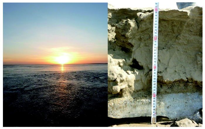
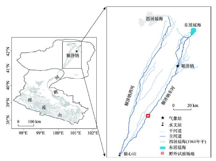

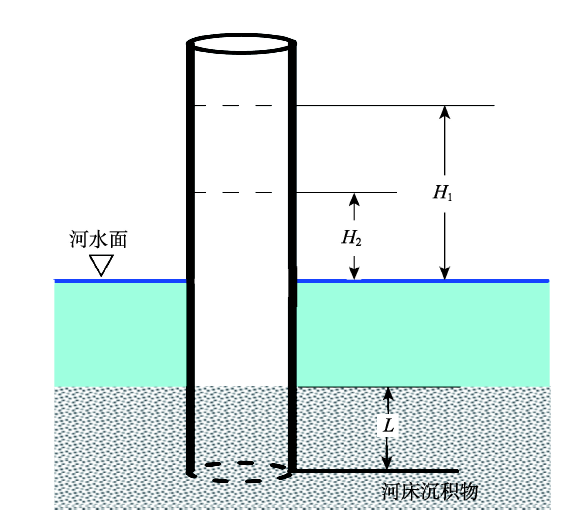

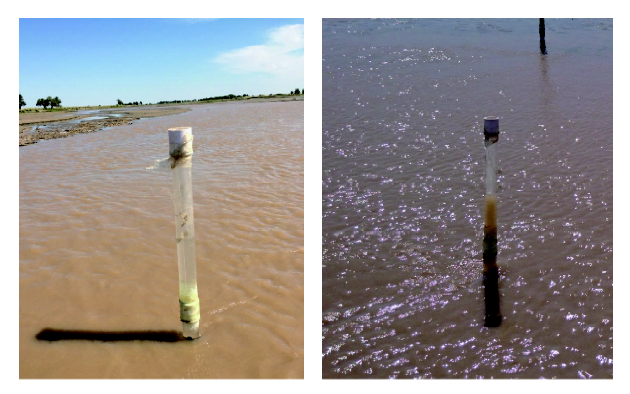