鹿化煜
LU Huayu
收稿日期: 2018-01-11
修回日期: 2018-01-13
网络出版日期: 2018-01-28
版权声明: 2018 地理科学进展 《地理科学进展》杂志 版权所有
基金资助:
作者简介:
作者简介:鹿化煜(1968-),男,陕西西安人,教授,主要从事地貌过程、古气候和全球变化研究,E-mail: huayulu@nju.edu.cn。
展开
摘要
地貌变化有内在的规律,对环境保育、资源利用和自然灾害防治有重要影响。作为交叉学科和地理学的重要分支学科,地貌学具有重要理论价值和实际意义。过去10多年来,随着遥感、地理信息技术和沉积物定年、地球物理和地球化学探测以及数值模拟等新技术和新方法的应用,地貌学家的研究视野和深度不断扩大与加深,在构造地貌、气候地貌和人类活动与地貌过程等传统领域有很多新进展,揭示了不同地貌单元的变化规律和机理,极大地推动了地貌学的发展。在新时代,除了继续加强传统地貌单元的深入研究外,地貌学的发展应与全球环境变化和未来地球等重大科学问题(计划)紧密结合;地貌学家要关心人类活动对地貌过程的影响及适应,并利用新技术开展地貌过程的定量重建和数值模拟。同时加强地理学专业学生的地质学基础学习、发展定量地貌学和行星地貌学、系统开展人类活动对地貌过程的影响和适应研究,是提升中国地貌学水平的途径,也可为推动国际地貌学发展做出贡献。
关键词:
Abstract
The formation and evolution of landform and landscape on Earth follow unique rules with specific forcing mechanisms. Earth surface processes have affected human environment, resource exploitation, and natural hazards and disasters. As an important branch of geography, geomorphology is an interdisciplinary field with important theoretical and practical values. With the application of remote sensing, geographical information system, digital elevation models, and sediment dating techniques, detection and tracing techniques of geophysics and geochemistry, and numerical simulation, the scope of geomorphology has been expanded and deepened over the past 10 years. Study on geomorphological process modulated by tectonic movement, climatic changes, gravity forcing, and human activities has greatly moved forward. New geomorphological processes and forcing mechanisms have been unraveled, and these recent achievements have significantly improved our understanding of Earth surface processes. In this new era of research, in addition to strengthening the study in traditional areas such as investigating different geomorphological processes at various temporal and spatial scales, bridging geomorphological research with global environment change and Future Earth programs is recommended. In particular, geomorphologists should pay much more attention to human activities, which is a vital agent that modulates Earth surface in the Anthropocene. Quantitatively reconstructing and modeling geomorphological processes are also an important area to explore. In China, to train geography students with more extensive and in-depth geological knowledge and practices, develop quantitative geomorphology and planetary geomorphology, and strengthen research on human impact on landform and topography will improve the quality of research, and promote geomorphology as a key discipline in Earth system science.
Keywords:
地貌学是研究地球表层地形和景观特征、分布及其形成和演化的科学,强调空间和时间演化过程,是联系地质学、地理学和气候学等的交叉学科。地表物质的侵蚀、堆积和地壳构造活动是影响地貌发育的重要因素。在新时代,对月球、火星等地貌形态和物质组成的研究,成为地貌学的新内容。可以说,地貌学是揭示地表过程和格局变化的重要科学。地貌过程影响着气候、水循环、生物、土壤等环境要素的分布格局,因此,地貌学是地理学的重要基础和分支,也是地球表层系统科学的重要组成部分。
地表是人类活动最重要的场所,也是与人类联系最直接的地球要素之一。人们的生活和生产活动在不同的地貌单元上进行,人类生存所依赖的水、土壤、动植物资源甚至于气候和交通条件等,都受到地貌的影响和控制。毫无疑问,全面认识不同时间和空间尺度地貌变化的规律和驱动机制,具有重要的理论和实际意义。
中国地貌类型多样,地表过程复杂,对环境影响大。加强中国的地貌学研究,不仅可为解决社会经济发展中遇到的资源和环境问题提供科学依据,对于推动国际地貌学学科的进步、发展地球表层系统科学,也有重要意义。本文基于作者在地貌学学习、研究和教学实践中的粗浅认识,结合调研分析最近10多年在《Geomorphology》《地理学报》《科学通报》《地理科学进展》等杂志发表的地貌学相关论文,评述地貌学的最新进展和未来趋势①。
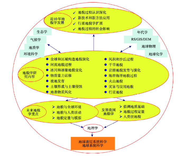
不同类型地貌发育过程的规律和驱动机制,依然是最近10多年来地貌学研究的重要内容。从南半球新西兰火山海岸小冰期的冰碛物组成和分布、到北美洲大平原地区沙丘活化与植被的联系;从青藏高原—喜马拉雅山地地貌发育对大江大河水系结构的控制,到植物根系发育过程对土壤沉积物分层的控制和影响,以及海岸盐沼植物对潮滩沟脊发育的作用和围垦对淤泥质海岸发育的影响等,都是当今地貌学家关心的重要内容,也是当前的热点地貌学问题。全球和区域构造地貌演化、河流地貌过程、冰川和冰缘地貌变化、物质重力运移和坡地发育、地表物质风化和土壤形成与侵蚀、风成沉积过程和沙丘动力过程与干旱地貌、岩溶地貌发育与演化、海岸海洋地貌过程与河口沉积动力、火山地貌、灾害与应用地貌和行星地貌等,是最近10年地貌学发展最为迅速的领域(程维明等, 2017; 莫多闻等, 2017; 徐志伟等, 2018; 并请参阅Geomorphology杂志2017-2018的论文)(图1)。国内外地貌学家围绕不同地貌体的形成过程、影响机制和发展过程展开研究(请参阅Journal of Geographical Sciences 2017第11期;请浏览9th International Conference on Geomorphology 2017网站)。地貌学问题跨越不同的时空尺度。在宏观尺度,研究问题包括:新生代欧亚板块强烈挤压控制青藏高原—喜马拉雅生长过程(鹿化煜等, 2013),由于全球气候变暖导致的热带太平洋地区数百公里区域的珊瑚死亡和珊瑚礁白化,或者是海面上升导致的全球海岸区域淹没和海岸带自然灾害加剧、影响数万公里的海岸线(Hughes et al, 2017)等。在微观尺度,研究问题包括:风蚀地区沙砾物质启动的风速阈值(崔梦淳等, 2015)、海岸大米草盐沼植物对潮滩冲沟的影响(Wang et al, 2012)等等,甚至于研究动物活动对地表形貌的影响(李华等, 2007),正形成一门新的动物地貌学(Zoogeomorphology)(Butler et al, 2018; Leonardi et al, 2018)。
图1 地貌学的研究内容及其与相邻学科的联系和未来发展
黄色区域是地貌学内容及其发展;蓝色区域是相关的学科。
Fig.1 Research of geomorphology in the past 10 years, its linkages with other disciplines, and the trend of development
The yellow area indicates the geomorphology, the blue area are other disciplines。
总结文献发现,在最近10多年,地貌学家围绕地表物质形态、地貌发育过程和驱动机制,对不同尺度地貌单元的形成、发育及它们之间的联系进行了深入研究,深化了我们对地貌过程的认识。相关的地貌学论文也逐年增多,体现出学科的繁荣。以国际地貌学杂志《Geomorphology》为例,2007年以来每年发表的论文数达到300余篇。
新技术和新方法的应用有力地推动了地貌学发展,深刻地揭示了地表物质运动规律和影响因素。主要体现在3个方面:①遥感技术(RS)、地理信息科学(包括地理信息系统(GIS)和数字高程模型(DEM)等);②年代学、地球化学与地球物理探测和示踪;③数值模型和计算技术。其中,遥感技术极大地扩大了地貌学家的视野范围,并能揭示地表物质运动的全过程。比如,通过遥感监测可以揭示强尘暴在中亚地区的起源、沿中高纬地区随着西风环流向东扩散、达到太平洋和北美洲甚至于格陵兰冰盖地区,为认识粉尘的长距离扩散和环境影响提供了直接证据(Uno et al, 2009; Lu W Y, 2017)。同样,长江、湄公河、尼罗河和密西西比河等大江大河携带的物质的搬运过程、在河口区的扩散和分布等,可从遥感影像直接观察到(Chen et al, 2007; Lee et al, 2018)。在侵蚀性淤泥质海岸潮汐叉道的形成和发育速度以及干旱沙漠中大型沙丘的移动速率(Xu et al, 2017; 黄骁力等, 2017)等方面,这些以前靠人工测量才能获得的数据,在高分辨率不同时序的遥感影像图上得到了很好的体现。可以说,遥感影像分析带来了地貌过程研究的一场革命,使我们以全新的视角和全域的空间尺度认识短时间尺度的地貌过程和地表物质迁移。同时,基于遥感技术和地理信息大数据分析,可揭示不同时间和空间尺度地貌单元间的相互作用和演化过程,成为现代地貌学分析的有力工具。另外,地貌过程的数值模拟和计算技术发展迅速,从黄土堆积侵蚀过程的数字高程模型预估到数值模拟(汤国安, 2014),以及河口三角洲增长过程极限模拟(Gao, 2007)等,从多个角度揭示地貌过程和趋向。应用上述技术,更加准确地揭示了地貌的发育过程,并为预测模拟服务。
揭示地貌演化的过程和规律,需要独立的时间标定。近10多年来,在十年—百年时间尺度的210Pb、137Cs定年,到千年—万年时间尺度的放射性14C、光释光,以及万年—百万年构造时间尺度宇成核素定年(如10Be-26Al埋藏年龄、Ar-Ar、锆石U-Pb)等定年技术的快速发展,加上传统的古生物地层、土壤地层和磁性地层等方法,使得我们可揭示不同时间尺度的地貌演化过程。最近发表的大量地貌演化方面的论文,很多都得益于这些定年技术的进步。
在对地球表层不同地貌体和地貌过程认识的基础上,随着遥感和空间探测技术的发展,揭示行星地表地貌过程,是最近10年强劲发展的领域。西方国家对于月球地貌的探索可追溯到20世纪60-70年代,并发展到现代的火星地貌研究(Grotzinger et al, 2015; Black et al, 2017 )。中国行星地貌学研究起步较晚,但在最近10多年来发展迅速,在完成了绕月和登陆月球工程后,获得了全月地貌地形图,揭示了月球地貌特征(王娇等, 2015; 周成虎, 2015)。中国探月计划的首要科学问题就是获取月球表面三维立体影像,精细划分月球表面的基本构造和地貌单元,进行月球表面撞击坑形态、大小、分布、密度等的研究,为类地行星表面年龄划分和早期演化历史研究提供基本数据,并为月面软着陆区选址和月球基地位置优选提供基础资料(Zhang et al, 2016)。这些恰恰是地貌学研究最基本的内容。同时,中国行星探测计划正在积极推进之中,行星地貌过程必将是未来地貌学家研究的主要内容之一。尤其是在中国行星地貌学家人数相对不多的情况下,开展行星地貌学的研究,具有不可替代的重要意义。
地貌学与人类活动和行为具有不可分割的相关性(Lu H Y et al, 2017)。滑坡、泥石流和沙尘暴等地表过程灾害对社会的影响已是不言而喻,尤其是在山地和干旱地区,已受到国际社会多方面的重视(崔鹏, 2014)。虽然已经意识到人类活动对地貌过程的深刻影响,但是相关的研究成果还较少。比如,英国诸多城市及其邻区人类活动对地表物质迁移速率和数量的影响,已经超过自然过程的数倍甚至于数十倍,但是,这些物质输移对环境的影响极其效应还没有得到精确的评估。在中国,高速城市化进程正在全面改变着地貌形态,这些地表变化如何影响城市环境、地表物质迁移是否有序和可持续,也需要评价。特别是地铁、地下商城、地下排水设施的大量建设,如何像地面上的规划有序、布局合理,并且减少对区域环境的影响,需要全面研究。随着地下场所的全面建设,绘制地下地貌图和地图,可能是未来地貌学与地图学交叉研究的重要内容之一。随着人类上天、入地活动的深入发展,地貌学家把眼光投向外空和地下已势在必行。
此外,地貌格局可能影响到全球尺度的环境污染评价和管理。在全球海岸地区的污染物排放中,不同洋流背景下污染物的输移和保存有较大的区别(Tessler et al, 2015)。同样,随着沉积物的输移和沉积,污染物质(如微塑料)的分布和富集与地貌动力过程联系密切,成为揭示污染物迁移、埋藏和释放的新研究方向。
从以上的分析可以看出,对地貌单元进行全面深入的研究,需要重视并结合遥感和地理信息技术、沉积物定年技术,以及对地貌过程的地球物理探测与地球化学示踪、地貌过程的数值模拟和预估等。同时,也应该看到,地貌学家只有把眼光投向关系人类生存发展的重大环境、资源以及灾害等问题,发挥地貌学研究的独特优势,才能提高地貌学的学科竞争力,使其真正成为地球系统科学基础的、重要的和前沿的学科方向,从而发展新时代的地貌学。基于这样的原因,地貌学家不仅要开展传统的地貌学问题研究,更要进行学科交叉,服务于国家战略,扩大地貌学的影响。
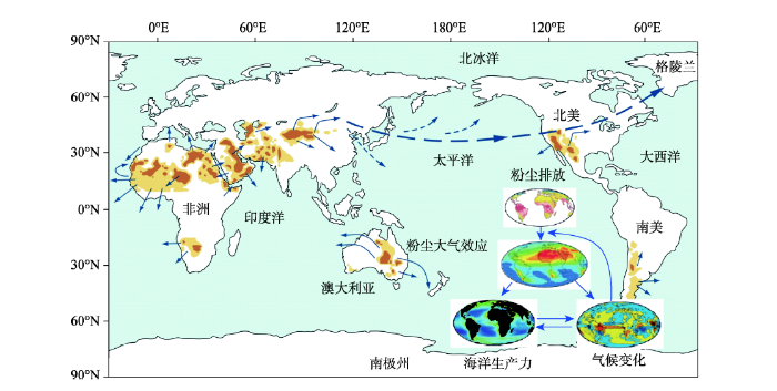
全球气候和环境变化是地球系统科学的前沿和重要科学问题之一。在未来地球(Future Earth)计划中,动态的星球(内容包括观测、解释和预测地球、环境和社会系统的变化趋势、驱动机制及相互作用)是3个重要议题之一。作为地球表层重要的要素,地貌过程在全球环境变化中起着重要的作用,有时甚至于是决定性作用。比如,我们正在承担的美国科学基金会项目(NSF-PIRE)和国家重点研发计划项目(2016YFE010950),探索的科学问题就是亚洲的地貌变化如何影响全球气候。亚洲地貌发育与全球变化联系的可能机制为:亚洲南部青藏高原—喜马拉雅地貌抬升—高原和山地周边大量的物质不断堆积、以及亚洲中部干旱加剧—粉尘释放增多—太平洋高纬中部“铁肥效应”增强—海洋生物(特别是浮游生物)繁盛—吸收和消耗更多的大气CO2 (draw down CO2)—全球气候变冷(图2)(Jickells et al, 2005; Garzione et al, 2015)。当然,这一假说是否成立,还需要更多的研究和事实检验。但可以确信,地貌过程在全球变化中发挥着重要作用,它可能是全球环境演化的“起搏器”;也可能是全球变化的响应者,并对全球环境变化有反馈作用。在未来地球和全球变化中,地貌学家肯定能够发挥重要作用。
图2 亚洲和全球的粉尘循环过程及其在地球环境变化中作用 (
Fig.2 Dust circulation process in the Earth system and its effect on global environmental change (
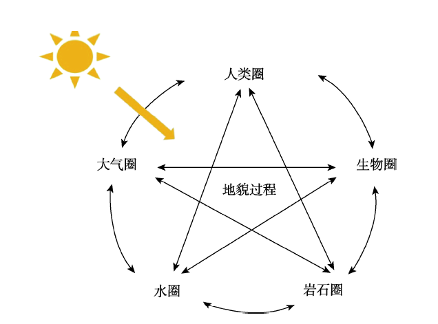
人类活动已成为地貌过程的重要应力,人类世(Anthropocene)已成为独立于已有地史单元的新成员。在这一新时代背景下,人类活动已经与大气环流、生物作用、岩石圈风化和水文循环等,成为影响地表过程的重要因素。人类圈的概念也相应诞生(图3)。作为揭示地表物质形态变化过程的地貌学,考虑人类活动的影响、揭示人类活动在地貌过程中的作用,必然是重要的研究内容。从最近10多年、尤其是近几年发表的地貌学相关的论文来看,有关人类因素的论文越来越多。这反映了地貌学研究的新趋势。
图3 地貌过程在人类世中的作用:地貌过程受到自然环境变化和人类活动的综合影响 (
Fig.3 Geomorphology and the Anthropocene: Linking the geomorphological processes, environmental change, and human activities (
作为自然科学的地貌学,与地质学、气候学、生态学、环境科学等学科有着密切的联系。地貌过程与地球要素的联系在不同的时间和空间尺度上存在差异。为了更好地揭示地貌过程的规律和机制,及其与其他要素的联系和相互作用,需要加强地貌过程的定量研究。比如,我们要揭示全球沙漠形成和演化的规律,就必须对各个沙漠的形成时代、气候背景和生态要素等有准确的认识和定量表达。这样,可在时间和空间上进行对比分析,找出其间的联系和异同。另外,作为复杂的地貌系统,简单的描述和分析,难以揭示地貌过程的真实面目、内在的动力过程和要素间复杂的响应与反馈机制;建立相应的数值模型,是最终认识地貌演化规律、影响因素和预测未来趋势的必由之路。因此,地貌过程的定量化重建和数值模拟,是未来研究中必须加强的方向。
纵观10多年来中国地貌学发展,可以看出,中国科学家在地貌过程及驱动机制和环境、资源效应等方面取得了很多重要的成果。比如,在新生代青藏高原—喜马拉雅的形成演化及其效应、沙漠—戈壁的起源演化与环境效应、河流地貌、海岸地貌、冰川—冰缘地貌、丹霞地貌、山地过程与灾害、地貌工程等领域,发表了大量高水平的论文、解决了实际生产中的诸多问题。同时,也应看到,中国地貌学研究的系统性和深入程度还有待提高,尤其是在培养人才方面,以前的一些做法也需要改进,以迎接新时代地貌学发展的挑战。
从近10年来的《地理学报》《地理科学进展》《科学通报》和《中国科学》等学术刊物可以看出,不少地貌学相关论文的地质学基础较为薄弱,诸多地貌学论文对基础地质数据和地质过程的理解表面化。因此,有些论文对于地貌学问题的理解和分析是片面的甚至于出现错误。一方面,在大学的地理教育中,需要强化《普通地质学》《构造地质学》和《沉积学》等基础地质学的教育和训练,加强地貌专业学生的地质学基础;另一方面,具有地理背景的地貌学家要加强相关地质要素研究,多从地质过程的角度考虑地貌学的问题,以减少对地貌过程片面理解或者曲解。
中国地貌学研究中从事数据采集、实验和过程分析的人员相对多,从事数值模拟的人员少。因而,定性描述的传统地貌过程研究论文多,定量分析地貌动力和演化过程的论文少。在未来的地貌学研究中,对于典型地貌过程的定量表达与模拟是必然的趋势之一,需要加强相关人员的培养和支持。同时,部分从事地貌模拟的年轻人员过于相信模型输出的结果,弱化了地貌过程的实际考察和实验验证,以至于一个“看上去不错”的模型输出结果,但与实际地貌过程相去甚远,甚至是错误的。这些问题在一些年轻地貌学家的论文和报告中已经显现。作为未来优秀的地貌学研究,必须做到数值模拟结果和实际定量分析的统一。
随着人类世(Anthropocene)的到来,人类活动作为一种地貌应力,深刻地改变着地貌过程。在这种背景下,加强人类活动对地貌过程的影响研究,指导人类活动对地貌灾害的适应,是地貌学家义不容辞的责任(Lu H Y et al, 2017)。在中国相关人类世地貌过程的研究已经开展,比如三峡大坝建设对流域及河口、海岸地貌过程的影响(Chen et al, 2007),沿海围垦工程的资源和环境效应,城市化过程中的水文效应(Du et al, 2012)和地面沉降、地裂缝等问题,表明中国地貌学家在认识人类世及其影响方面的积极态度。中国是一个人口大国,尤其是东部和中部人口密度大、人类活动影响地貌过程的强度高、速率快、范围广,甚至可以说,人类活动已经影响到地貌过程的各个环节。这些地貌过程的改变会带来何种资源、环境和灾害问题,是地貌学家需要特别关注的内容。
最近10多年来,国内外在传统的地貌学领域,向过程分析、定量化重建和机理理解不断前进,加强了遥感和地理信息技术、年代学、地球物理和地球化学以及数值模拟等技术的应用,对地貌过程的认识不断深入。同时,应该认识到,未来将地貌过程与全球环境变化、人类世资源和灾害问题、数值模拟与预估等结合,才能解决地貌学中的复杂问题,提高地貌学学科竞争力,为发展地球表层系统科学和国家经济建设服务。加强地质学基础教育和培训、重视地貌过程定量表达和分析、重视人类活动对地貌过程的影响,是提升中国地貌学水平的重要途径。
致谢:感谢傅伯杰院士、赵文武教授的组织、约稿和修改。感谢王晓勇副教授、研究生吕娜娜、常茜在论文插图、文献核对等方面的帮助。感谢王晓勇副教授、王先彦教授和徐志伟博士阅读原文并提出宝贵的修改意见。感谢审稿人提出的宝贵修改意见。
The authors have declared that no competing interests exist.
| [1] |
中国近40年来地貌学研究的回顾与展望 [J].https://doi.org/10.11821/dlxb201705001 URL [本文引用: 1] 摘要
地貌学是地理学的一门主要分支学科,其研究成就与发展一直倍受人们关注。本文对中国近60年来的研究状况,尤其近40年来研究历程进行了回顾,从总结经验与发展态势出发,对地貌学科未来发展方向提出了展望。分析认为,中国地貌学科在地貌基本类型、区划以及分支学科:包括动力地貌学(包括冰川地貌、冰缘地貌、风沙地貌、黄土地貌、喀斯特地貌、河流地貌、海岸地貌等)、构造地貌学、气候地貌学、古地貌、岩石地貌学(包括丹霞地貌、花岗岩与流纹岩地貌)、其他地貌类型(包括重力地貌,人工地貌)等方面取得重大进展,地貌学已逐渐发展成为一门拥有完整学科体系的科学。通过回顾认为,应坚持地貌成因、形态相统一的原则发展传统地貌与综合地貌。加强地貌基础理论与综合地貌研究、开展地貌结构及其功能研究、构建全方位资源环境地貌信息系统、加强海岸地貌与海洋地貌研究、加强人才培养和学术团队建设,将是中国实现地貌强国目标的主要途径。
Retrospect and perspective of geomorphology researches in China over the past 40 years [J].https://doi.org/10.11821/dlxb201705001 URL [本文引用: 1] 摘要
地貌学是地理学的一门主要分支学科,其研究成就与发展一直倍受人们关注。本文对中国近60年来的研究状况,尤其近40年来研究历程进行了回顾,从总结经验与发展态势出发,对地貌学科未来发展方向提出了展望。分析认为,中国地貌学科在地貌基本类型、区划以及分支学科:包括动力地貌学(包括冰川地貌、冰缘地貌、风沙地貌、黄土地貌、喀斯特地貌、河流地貌、海岸地貌等)、构造地貌学、气候地貌学、古地貌、岩石地貌学(包括丹霞地貌、花岗岩与流纹岩地貌)、其他地貌类型(包括重力地貌,人工地貌)等方面取得重大进展,地貌学已逐渐发展成为一门拥有完整学科体系的科学。通过回顾认为,应坚持地貌成因、形态相统一的原则发展传统地貌与综合地貌。加强地貌基础理论与综合地貌研究、开展地貌结构及其功能研究、构建全方位资源环境地貌信息系统、加强海岸地貌与海洋地貌研究、加强人才培养和学术团队建设,将是中国实现地貌强国目标的主要途径。
|
| [2] |
便携式粉尘观测仪测定腾格里沙漠和毛乌素沙地PM10释放通量 [J].https://doi.org/10.1360/n972014-01157 URL [本文引用: 1] 摘要
中国北方沙漠和沙地是亚洲粉尘释放的重要源区,定量估算这一地区的粉尘释放量有助于评估区域大气环境质量及其气候效应.目前,对中国北方粉尘释放量的估算主要是基于模拟结果,野外直接观测数据很少.利用一种新型的粉尘释放观测仪器——便携式粉尘观测仪(PI-SWERL),测量腾格里沙漠和毛乌素沙地若干典型地表(沙丘、干湖、灌丛沙丘、河流冲积物等)的粉尘释放通量,获得了不同地表潜在粉尘释放量的直接观测数据.结果表明,不同地表的PM10释放通量存在较大差异,但均随摩阻风速的增加而增加.在相同的摩阻风速U*=0.55 m/s条件下,灌丛沙丘的PM10通量最高(0.70~10.23 mg/(m2 s)),河流冲积物次之(0.12~4.97 mg/(m2 s)),干湖湖底、沙丘等地表的通量较小(0.5 mg/(m2 s)).对比试验表明,破碎结壳地表释放的PM10通量是未破碎结壳的几倍甚至几十倍;披覆松散沙粒结壳地面的PM10释放通量高出未披覆的1~2个数量级.对比前人研究结果,PI-SWERL可以较好地反映不同源区粉尘释放的差异,对定量评估区域乃至全球的粉尘释放量等具有重要意义.
PM10 emission flux in the Tengger Desert and Mu Us Sand field, northern China, measured by PI-SWERL [J].https://doi.org/10.1360/n972014-01157 URL [本文引用: 1] 摘要
中国北方沙漠和沙地是亚洲粉尘释放的重要源区,定量估算这一地区的粉尘释放量有助于评估区域大气环境质量及其气候效应.目前,对中国北方粉尘释放量的估算主要是基于模拟结果,野外直接观测数据很少.利用一种新型的粉尘释放观测仪器——便携式粉尘观测仪(PI-SWERL),测量腾格里沙漠和毛乌素沙地若干典型地表(沙丘、干湖、灌丛沙丘、河流冲积物等)的粉尘释放通量,获得了不同地表潜在粉尘释放量的直接观测数据.结果表明,不同地表的PM10释放通量存在较大差异,但均随摩阻风速的增加而增加.在相同的摩阻风速U*=0.55 m/s条件下,灌丛沙丘的PM10通量最高(0.70~10.23 mg/(m2 s)),河流冲积物次之(0.12~4.97 mg/(m2 s)),干湖湖底、沙丘等地表的通量较小(0.5 mg/(m2 s)).对比试验表明,破碎结壳地表释放的PM10通量是未破碎结壳的几倍甚至几十倍;披覆松散沙粒结壳地面的PM10释放通量高出未披覆的1~2个数量级.对比前人研究结果,PI-SWERL可以较好地反映不同源区粉尘释放的差异,对定量评估区域乃至全球的粉尘释放量等具有重要意义.
|
| [3] |
中国山地灾害研究进展与未来应关注的科学问题 [J].https://doi.org/10.11820/dlkxjz.2014.02.001 URL [本文引用: 1] 摘要
本文首先简要回顾了山地灾害研究与防治方面的新进展:认识了山地灾害的空间分布规律,建立了山洪、泥石流、滑坡危险性评价方法;发展了滑坡稳定性分析的原理和计算方法,建立了泥石流流体应力本构关系、泥石流流速流量和冲击力计算公式、粘性泥石流起动模型,提出了山洪和泥石流规模放大效应;基于降雨和地面成灾环境要素耦合分析,发展了山地灾害气象预报方法;基于对灾害物理特性的认识,研发了一系列灾害监测预警仪器、数字流域平台与智能手机网络相结合的山洪预警系统;发展了灾害治理工程技术,形成了适合欠发达地区特点的灾害治理技术体系。在此基础上,分析了在灾害形成、运动、预测预报、防治技术和风险管理等方面还需要进一步深化研究的问题,提出山地灾害学科今后面临的任务。最后,针对国家减灾需求和学科发展目标,提出灾害对生态的响应机制、气候变化对山地灾害的影响与巨灾预测、水—土耦合的细观结构力学、灾害风险的理论与方法、基于灾害形成理论的机理预报模式、灾害防治技术规程的健全等未来应该关注的科学技术问题。
Progress and prospects in research on mountain hazards in China [J].https://doi.org/10.11820/dlkxjz.2014.02.001 URL [本文引用: 1] 摘要
本文首先简要回顾了山地灾害研究与防治方面的新进展:认识了山地灾害的空间分布规律,建立了山洪、泥石流、滑坡危险性评价方法;发展了滑坡稳定性分析的原理和计算方法,建立了泥石流流体应力本构关系、泥石流流速流量和冲击力计算公式、粘性泥石流起动模型,提出了山洪和泥石流规模放大效应;基于降雨和地面成灾环境要素耦合分析,发展了山地灾害气象预报方法;基于对灾害物理特性的认识,研发了一系列灾害监测预警仪器、数字流域平台与智能手机网络相结合的山洪预警系统;发展了灾害治理工程技术,形成了适合欠发达地区特点的灾害治理技术体系。在此基础上,分析了在灾害形成、运动、预测预报、防治技术和风险管理等方面还需要进一步深化研究的问题,提出山地灾害学科今后面临的任务。最后,针对国家减灾需求和学科发展目标,提出灾害对生态的响应机制、气候变化对山地灾害的影响与巨灾预测、水—土耦合的细观结构力学、灾害风险的理论与方法、基于灾害形成理论的机理预报模式、灾害防治技术规程的健全等未来应该关注的科学技术问题。
|
| [4] |
地貌发育演化研究的空代时理论与方法 [J].https://doi.org/10.11821/dlxb201701008 URL [本文引用: 1] 摘要
地貌的发育在特定的条件下往往呈现空间分布上由“新”至“老”的过渡,据此,对地貌类型与特征在空间上的序列采样,即可为研究某种地貌的个体发育提供基本依据.该方法即为地貌学研究中的空代时.本文首先介绍了空代时方法产生的背景与基本概念.分析了近年来空代时方法应用于河流地貌、构造地貌、河口海岸地貌等不同地貌类型演化过程的研究进展.在此基础上,明确了空代时方法在地貌学研究中的适用条件、影响因素及分类体系,并提出了地貌学空代时的研究范式.本文认为今后的研究工作一方面应充分利用海量的地理空间数据,运用空代时方法研究多种空间尺度下的地貌演化的问题;另一方面,应结合现有的物理机制和统计规律,构建集形、数、理一体化的地貌演化模型.
Theories and methods of space-for-time substitution in geomorphology [J].https://doi.org/10.11821/dlxb201701008 URL [本文引用: 1] 摘要
地貌的发育在特定的条件下往往呈现空间分布上由“新”至“老”的过渡,据此,对地貌类型与特征在空间上的序列采样,即可为研究某种地貌的个体发育提供基本依据.该方法即为地貌学研究中的空代时.本文首先介绍了空代时方法产生的背景与基本概念.分析了近年来空代时方法应用于河流地貌、构造地貌、河口海岸地貌等不同地貌类型演化过程的研究进展.在此基础上,明确了空代时方法在地貌学研究中的适用条件、影响因素及分类体系,并提出了地貌学空代时的研究范式.本文认为今后的研究工作一方面应充分利用海量的地理空间数据,运用空代时方法研究多种空间尺度下的地貌演化的问题;另一方面,应结合现有的物理机制和统计规律,构建集形、数、理一体化的地貌演化模型.
|
| [5] |
潮间带盐沼植物对海岸沉积动力过程影响的研究进展 [J].https://doi.org/10.3321/j.issn:1001-8166.2007.06.004 URL [本文引用: 1] 摘要
根据已有文献归纳出盐沼植物对水动力、悬沙运动、沉积、地貌影响研究已取得的进展,包括:①单位距离盐沼中波能的损失可为相邻光滩的数倍至数十倍;波浪传入互花米草盐沼20~30m后,波能可全部损失;②盐沼植物可使潮流流速降低一个数量级;当植冠被淹没后,垂向流速剖面在植冠附近出现转折;③当植冠被淹没后,垂向上植冠层内的紊动强度趋于一致且明显低于植冠层以上;互花米草盐沼中的紊动强度可比相邻光滩低1~2个数量级;④盐沼植物通过2种机制影响悬沙的运动:其一是降低水体紊动,从而促进悬沙的沉降并遏制滩面沉积物再悬浮;其二是茎叶对悬沙的直接黏附。这两种机制可使盐沼中的悬沙浓度比相邻光滩低一半以上;⑤植物对细颗粒悬沙的促淤作用导致盐沼中的底床滩面沉积物细化;⑥盐沼中的垂向沉积速率可比光滩高7~8倍;盐沼中波痕和侵蚀坑等微地貌不易发育,滩面平整化;与光滩上频繁发生的冲淤交替相比,盐沼中通常只淤不冲,滩面稳定性较高;⑦植物对上述沉积动力过程的影响程度与植物的高度、密度、盖度等生态参数密切相关,因此,不同的植物种类对沉积动力过程的影响往往存在显著差异。在此基础上,展望了今后该领域研究进一步加强的几个方面。
A review of influences of saltmarsh vegetation on physical processes in intertidal wetlands [J].https://doi.org/10.3321/j.issn:1001-8166.2007.06.004 URL [本文引用: 1] 摘要
根据已有文献归纳出盐沼植物对水动力、悬沙运动、沉积、地貌影响研究已取得的进展,包括:①单位距离盐沼中波能的损失可为相邻光滩的数倍至数十倍;波浪传入互花米草盐沼20~30m后,波能可全部损失;②盐沼植物可使潮流流速降低一个数量级;当植冠被淹没后,垂向流速剖面在植冠附近出现转折;③当植冠被淹没后,垂向上植冠层内的紊动强度趋于一致且明显低于植冠层以上;互花米草盐沼中的紊动强度可比相邻光滩低1~2个数量级;④盐沼植物通过2种机制影响悬沙的运动:其一是降低水体紊动,从而促进悬沙的沉降并遏制滩面沉积物再悬浮;其二是茎叶对悬沙的直接黏附。这两种机制可使盐沼中的悬沙浓度比相邻光滩低一半以上;⑤植物对细颗粒悬沙的促淤作用导致盐沼中的底床滩面沉积物细化;⑥盐沼中的垂向沉积速率可比光滩高7~8倍;盐沼中波痕和侵蚀坑等微地貌不易发育,滩面平整化;与光滩上频繁发生的冲淤交替相比,盐沼中通常只淤不冲,滩面稳定性较高;⑦植物对上述沉积动力过程的影响程度与植物的高度、密度、盖度等生态参数密切相关,因此,不同的植物种类对沉积动力过程的影响往往存在显著差异。在此基础上,展望了今后该领域研究进一步加强的几个方面。
|
| [6] |
晚新生代东亚气候变化: 进展与问题 [J].Evolution of the monsoon and dry climate in East Asia during late Cenozoic: A review [J]. |
| [7] |
北京大学地貌第四纪学科的创建与发展 [J].Establishment and development of geomorphology and Quaternary sciences at Peking University [J]. |
| [8] |
我国数字高程模型与数字地形分析研究进展 [J].Progress of DEM and digital terrain analysis in China [J]. |
| [9] |
全月球撞击坑识别、分类及空间分布 [J].A global inventory of lunar craters: Identification, classification, and distribution [J]. |
| [10] |
自然地理学发展迎来新时代: 从“2017年全国自然地理学大会”看自然地理学新发展与新挑战 [J].Ziran dilixue fazhan yinglai xin shidai: Cong "2017 nian quanguo ziran dilixue dahui" kan ziran dilixue xin fazhan yu xin tiaozhan [J]. |
| [11] |
全空间地理信息系统展望 [J].https://doi.org/10.11820/dlkxjz.2015.02.001 URL [本文引用: 1] 摘要
地理信息系统作为一门空间科学,以其独特的空间观点和空间思维,从空间相互联系和相互作用出发,揭示各种事物与现象的空间分布特征和动态变化规律。本文从地理信息系统所研究的空间对象出发,对地理信息系统发展新方向提出思考:1从地球空间拓展到宇宙空间,需要构建宇心坐标系和宇宙GIS、月球GIS等;2从室外空间延伸到室内空间,需要发展室内GIS,并拓展到水下空间和地下空间;3从宏观到微观空间,可以发展面向游戏的体育GIS、面向生命健康管理的人体GIS等;4面向大数据时代,发展大数据空间解析的理论和方法,贡献于大数据科学的发展。
Prospects on pan-spatial information system [J].https://doi.org/10.11820/dlkxjz.2015.02.001 URL [本文引用: 1] 摘要
地理信息系统作为一门空间科学,以其独特的空间观点和空间思维,从空间相互联系和相互作用出发,揭示各种事物与现象的空间分布特征和动态变化规律。本文从地理信息系统所研究的空间对象出发,对地理信息系统发展新方向提出思考:1从地球空间拓展到宇宙空间,需要构建宇心坐标系和宇宙GIS、月球GIS等;2从室外空间延伸到室内空间,需要发展室内GIS,并拓展到水下空间和地下空间;3从宏观到微观空间,可以发展面向游戏的体育GIS、面向生命健康管理的人体GIS等;4面向大数据时代,发展大数据空间解析的理论和方法,贡献于大数据科学的发展。
|
| [12] |
Global drainage patterns and the origins of topographic relief on Earth, Mars, and Titan [J].https://doi.org/10.1126/science.aag0171 URL PMID: 28522528 [本文引用: 1] 摘要
Rivers have eroded the topography of Mars, Titan, and Earth, creating diverse landscapes. However, the dominant processes that generated topography on Titan (and to some extent on early Mars) are not well known. We analyzed drainage patterns on all three bodies and found that large drainages, which record interactions between deformation and erosional modification, conform much better to long-wavelength topography on Titan and Mars than on Earth. We use a numerical landscape evolution model to demonstrate that short-wavelength deformation causes drainage directions to diverge from long-wavelength topography, as observed on Earth. We attribute the observed differences to ancient long-wavelength topography on Mars, recent or ongoing generation of long-wavelength relief on Titan, and the creation of short-wavelength relief by plate tectonics on Earth.
|
| [13] |
Zoogeomorphology in the Anthropocene [J].https://doi.org/10.1016/j.geomorph.2017.12.003 URL [本文引用: 1] 摘要
This project will employ a variety of field methods (transect sampling, quadrat sampling, water quality analyses) to explore variables that will feed into a habitat model for the North American bea…" [more]
|
| [14] |
Monsoon rivers of Asia [J].https://doi.org/10.1016/j.geomorph.2006.08.001 URL [本文引用: 2] |
| [15] |
Assessing the effects of urbanization on annual runoff and flood events using an integrated hydrological modeling system for Qinhuai River basin, China [J].https://doi.org/10.1016/j.jhydrol.2012.06.057 URL [本文引用: 1] 摘要
This study developed and used an integrated modeling system, coupling a distributed hydrologic and a dynamic land-use change model, to examine effects of urbanization on annual runoff and flood events of the Qinhuai River watershed in Jiangsu Province, China. The Hydrologic Engineering Center Hydrologic Modeling System (HEC-HMS) was used to calculate runoff generation and the integrated Markov Chain and Cellular Automata model (CA-Markov model) was used to develop future land use maps. The model was calibrated and validated using observed daily streamflow data collected at the two outlets of watershed. Landsat Thematic Mapper (TM) images from 1988, 1994, 2006, Enhanced Thematic Mapper Plus (ETM+) images from 2001, 2003 and a China razil Earth Resources Satellite (CBERS) image from 2009 were used to obtain historical land use maps. These imageries revealed that the watershed experienced conversion of approximately 17% non-urban area to urban area between 1988 and 2009. The urbanization scenarios for various years were developed by overlaying impervious surfaces of different land use maps to 1988 (as a reference year) map sequentially. The simulation results of HEC-HMS model for the various urbanization scenarios indicate that annual runoff, daily peak flow, and flood volume have increased to different degrees due to urban expansion during the study period (1988 2009), and will continue to increase as urban areas increase in the future. When impervious ratios change from 3% (1988) to 31% (2018), the mean annual runoff would increase slightly and the annual runoff in the dry year would increase more than that in the wet year. The daily peak discharge of eight selected floods would increase from 2.3% to 13.9%. The change trend of flood volumes is similar with that of peak discharge, but with larger percentage changes than that of daily peak flows in all scenarios. Sensitivity analysis revealed that the potential changes in peak discharge and flood volume with increasing impervious surface showed a linear relationship, and the changes of small floods were larger than those of large floods with the same impervious increase, indicating that the small floods were more sensitive than large floods to urbanization. These results suggest that integrating distributed land use change model and distributed hydrological model can be a good approach to evaluate the hydrologic impacts of urbanization, which are essential for watershed management, water resources planning, and flood management for sustainable development.
|
| [16] |
Physical geography in the Anthropocene [J].https://doi.org/10.1177/0309133317736424 URL [本文引用: 2] 摘要
react-text: 387 Exploring the global ecological patterns created by sustained direct human interactions with ecosystems. /react-text react-text: 388 /react-text
|
| [17] |
Modeling the growth limit of the Changjiang Delta [J].https://doi.org/10.1016/j.geomorph.2006.03.021 URL [本文引用: 1] 摘要
River deltas grow in response to sediment discharge from the land. It is not clear, however, whether or not there is a limit for such growth. Conceptual geometric models are used in this paper, in association with the principle of mass conservation, in an attempt to answer this question. Preliminary analyses of the Changjiang Delta indicate that delta growth is constrained by a number of factors: the original topography/bathymetry, sediment supply, sediment retention in the estuary, sea-level rise, ground subsidence. The quantity of sediment supply per unit area and the Sediment Retention Index for the subaqueous delta decrease as the delta progrades towards deeper water, resulting in a decreasing rate of growth. The limit of growth is reached when the index approaches zero, i.e. the shoreline reaches the shelf edge. If the combined effect of sea-level rise and ground subsidence is considered together with decrease in the sediment discharge from land, the limit is reached at an earlier stage. For the Changjiang Delta, the model output (using hypothesized Sediment Retention Index estimates) implies that the delta growth will reach its limit in the near future. This will occur sooner if the sediment output of the river is reduced to 60% of its original level, in response to the upstream basin changes. Further knowledge, however, is required of the Retention Index, together with the information on future changes in river input and the character of the sediments in order to improve the accuracy of the simulations.
|
| [18] |
PIRE: Dust stimulated draw-down of atmospheric CO2 as a trigger for Northern Hemisphere Glaciation[R]. Alexandria, Virginia: |
| [19] |
Deposition, exhumation, and paleoclimate of an ancient lake deposit, Gale crater, Mars [J].https://doi.org/10.1126/science.aac7575 URL PMID: 26450214 [本文引用: 1] 摘要
The landforms of northern Gale crater on Mars expose thick sequences of sedimentary rocks. Based on images obtained by the Curiosity rover, we interpret these outcrops as evidence for past fluvial, deltaic, and lacustrine environments. Degradation of the crater wall and rim probably supplied these sediments, which advanced inward from the wall, infilling both the crater and an internal lake basin to a thickness of at least 75 meters. This intracrater lake system probably existed intermittently for thousands to millions of years, implying a relatively wet climate that supplied moisture to the crater rim and transported sediment via streams into the lake basin. The deposits in Gale crater were then exhumed, probably by wind-driven erosion, creating Aeolis Mons (Mount Sharp).
|
| [20] |
Coral reefs in the Anthropocene [J].https://doi.org/10.1038/nature22901 URL PMID: 28569801 [本文引用: 1] 摘要
Coral reefs support immense biodiversity and provide important ecosystem services to many millions of people. Yet reefs are degrading rapidly in response to numerous anthropogenic drivers. In the coming centuries, reefs will run the gauntlet of climate change, and rising temperatures will transform them into new configurations, unlike anything observed previously by humans. Returning reefs to past configurations is no longer an option. Instead, the global challenge is to steer reefs through the Anthropocene era in a way that maintains their biological functions. Successful navigation of this transition will require radical changes in the science, management and governance of coral reefs.
|
| [21] |
Global iron connections between desert dust, ocean biogeochemistry, and climate [J].URL PMID: 15802595 [本文引用: 3] 摘要
Abstract The environmental conditions of Earth, including the climate, are determined by physical, chemical, biological, and human interactions that transform and transport materials and energy. This is the "Earth system": a highly complex entity characterized by multiple nonlinear responses and thresholds, with linkages between disparate components. One important part of this system is the iron cycle, in which iron-containing soil dust is transported from land through the atmosphere to the oceans, affecting ocean biogeochemistry and hence having feedback effects on climate and dust production. Here we review the key components of this cycle, identifying critical uncertainties and priorities for future research.
|
| [22] |
Regional landslide susceptibility assessment using multi-stage remote sensing data along the coastal range highway in northeastern Taiwan [J].https://doi.org/10.1016/j.geomorph.2017.10.019 URL [本文引用: 1] 摘要
Abstract Typhoons Megi (2010) and Saola (2012) brought torrential rainfall which triggered regional landslides and flooding hazards along Provincial Highway No. 9 in northeastern Taiwan. To reduce property loss and saving lives, this study combines multi-hazard susceptibility assessment with environmental geology map a rock mass rating system (RMR), remote sensing analysis, and micro-topography interpretation to develop an integrated landslide hazard assessment approach and reflect the intrinsic state of slopeland from the past toward the future. First, the degree of hazard as indicated by historical landslides was used to determine many landslide regions in the past. Secondly, geo-mechanical classification of rock outcroppings was performed by in-situ investigation along the vulnerable road sections. Finally, a high-resolution digital elevation model was extracted from airborne LiDAR and multi-temporal remote sensing images which was analyzed to discover possible catastrophic landslide hotspot shortly. The results of the analysis showed that 37% of the road sections in the study area were highly susceptible to landslide hazards. The spatial distribution of the road sections revealed that those characterized by high susceptibility were located near the boundaries of fault zones and in areas of lithologic dissimilarity. Headward erosion of gullies and concave-shaped topographic features had an adverse effect and was the dominant factor triggering landslides. Regional landslide reactivation on this coastal highway are almost related to the past landslide region based on hazard statistics. The final results of field validation demonstrated that an accuracy of 91% could be achieved for forecasting geohazard followed by intense rainfall events and typhoons
|
| [23] |
Dynamic interactions between coastal storms and salt marshes: A review [J].https://doi.org/10.1016/j.geomorph.2017.11.001 URL [本文引用: 1] 摘要
Abstract This manuscript reviews the progresses made in the understanding of the dynamic interactions between coastal storms and salt marshes, including the dissipation of extreme water levels and wind waves across marsh surfaces, the geomorphic impact of storms on salt marshes, the preservation of hurricanes signals and deposits into the sedimentary records, and the importance of storms for the long term survival of salt marshes to sea level rise. A review of weaknesses, and strengths of coastal defences incorporating the use of salt marshes including natural, and hybrid infrastructures in comparison to standard built solutions is then presented. Salt marshes are effective in dissipating wave energy, and storm surges, especially when the marsh is highly elevated, and continuous. This buffering action reduces for storms lasting more than one day. Storm surge attenuation rates range from 1.7 to 25 cm/km depending on marsh and storms characteristics. In terms of vegetation properties, the more flexible stems tend to flatten during powerful storms, and to dissipate less energy but they are also more resilient to structural damage, and their flattening helps to protect the marsh surface from erosion, while stiff plants tend to break, and could increase the turbulence level and the scour. From a morphological point of view, salt marshes are generally able to withstand violent storms without collapsing, and violent storms are responsible for only a small portion of the long term marsh erosion. Our considerations highlight the necessity to focus on the indirect long term impact that large storms exerts on the whole marsh complex rather than on sole after-storm periods. The morphological consequences of storms, even if not dramatic, might in fact influence the response of the system to normal weather conditions during following inter-storm periods. For instance, storms can cause tidal flats deepening which in turn promotes wave energy propagation, and exerts a long term detrimental effect for marsh boundaries even during calm weather. On the other hand, when a violent storm causes substantial erosion but sediments are redistributed across nearby areas, the long term impact might not be as severe as if sediments were permanently lost from the system, and the salt marsh could easily recover to the initial state.
|
| [24] |
Earth surface processes and their effects on human behavior in monsoonal China during the Pleistocene-Holocene epochs [J].https://doi.org/10.1007/s11442-017-1437-x URL [本文引用: 2] 摘要
There is a wide diversity of landforms in China.The topography of three major terraces,decreasing in height stepwise from west to east,was formed by the early Miocene.With the commencement of the Great Northern Hemisphere Glaciations (GHGs) and the glacial-interglacial cycles in the Pleistocene,thick loess deposits accumulated in north China,and fluvial terraces were formed and lakes expanded and contracted in eastern and central China.The earliest evidence of hominins in China is dated to 1.7 Ma;they occupied the monsoon-dominated region for a long interval,until the late Pleistocene, 50 ka.In this study,we investigated a large area rich in the relics and artifacts of early man.The results indicate that the early humans occupied riverine areas,especially medium-sized fluvial basins,and lake shores.Even in the relatively recent geological past,the occupation and abandonment of settlements were directly forced by the shifting of sand dune fields in the desert-loess transitional zone,which in turn was closely associated with variations in the monsoon climate and vegetation patterns.Our observations indicate that landforms were one of the main determinants of early human behavior,in that loess tableland,large alluvial plains,desert-Gobi areas,and the Tibetan Plateau,were not suitable environments for early human settlement.We infer that the early humans in China adapted their behavior to specific landforms and landform processes.The monsoon climate,which shapes the large-scale step-like pattern of fluvial landforms,promotes vegetation coverage and dominates soil formation,provides a crucial context for early human adaptation.The adaptation of early humans to earth surface processes in East Asia is investigated for the first time in this study.Future investigations will provide further information that will increase our understanding of the linkage between early human behavior and landform processes in East Asia.
|
| [25] |
Iron mineralogy and speciation in clay-sized fractions of Chinese desert sediments [J].
Abstract Iron released from Asian desert dust may be an important source of bioavailable iron for the North Pacific Ocean and thereby may stimulate primary productivity. However, the Fe species of the fine dusts from this source region are poorly characterized. Here we investigate iron species and mineralogy in the clay-sized fractions (< 2 m, CSFS), the size fraction most prone to long-distance transport as dust. Samples were analyzed by sequential chemical extraction, X-ray diffraction and diffuse reflectance spectrometry. Our results show that Fe dissolved from easily reducible iron phases (ferrihydrite and lepidocrocite) and reducible iron oxides (dominated by goethite) are 0.81 wt.% and 2.39 wt.% respectively, and Fe dissolved from phyllosilicates extracted by boiling HCl (dominated by chlorite) is 3.15 wt.%. Dusts originating from deserts in north-western China, particularly the Taklimakan desert, are relatively enriched in easily reducible Fe phases, probably due to abundant Fe contained in fresh weathering products resulting from the rapid erosion associated with active uplift of mountains to the west. Data about Fe speciation and mineralogy in Asian dust sources will be useful for improving the quantification of soluble Fe supplied to the oceans, especially in dust models.
|
| [26] |
Profiling risk and sustainability in coastal deltas of the world [J].https://doi.org/10.1126/science.aab3574 URL [本文引用: 1] |
| [27] |
Asian dust transported one full circuit around the globe [J].https://doi.org/10.1038/ngeo583 URL [本文引用: 1] 摘要
Each month, Nature Geoscience will bring you top-quality research papers, reviews and opinion pieces - in print and online.
|
| [28] |
Sediment transport over an accretional intertidal flat with influences of reclamation, Jiangsu coast, China [J].https://doi.org/10.1016/j.margeo.2011.01.004 URL [本文引用: 1] 摘要
78 Hydrodynamic and sediment transport have responses to reclamations on tidal flat. 78 Suspended sediment fluxes are dominated by the longshore component. 78 Onshore–offshore fluxes provide sufficient sediment supply for tidal flat accretion. 78 Fine-grained sediment transport onshore, together with coarse sediment offshore. 78 Tidal flat equilibrium shape of cross-section cannot maintain under reclamations.
|
| [29] |
Crescentic dune migration and stabilization: Implications for interpreting paleo-dune deposits as paleoenvironmental records [J].https://doi.org/10.1007/s11442-017-1439-8 URL [本文引用: 1] 摘要
Paleo-dune deposits have been widely used as a proxy indicator of past dune activity, which is further used to reconstruct paleoclimates. However, recent studies have critically examined the reproducibility of dune chronologies and the complexity of paleo-dune deposits as paleoenvironmental records. This paper addresses questions on the paleoenvironmental implications of dune chronostratigraphies that have been raised by those reviews, in the specific case of crescentic dunes, using a case study from the Mu Us dune field, north-central China. The processes of turn-over and stabilization of relatively small crescentic dunes are first investigated by observational evidence. In combination with the analysis of a simplified sand preservation model and stratigraphic records, the effect of dune morphodynamics on sand preservation is demonstrated. It is especially evident that thick, nearly instantaneously deposited sand units record dune stabilization near the very end of a dune activity episode, while thin sand units may signal the preservation of sand deposited earlier in episodes of activity. Interpreting the distribution of luminescence ages that indicate sand deposition over time is not as simple as assumed in some previous work. Low frequency of sand ages could indicate an interval of either dune field stabilization or extensive dune activity but poor sand preservation. A peak of sand age frequency likely represents a shift in dune field activity towards stabilization, not a peak of active dune extent, especially if it partially overlaps with an independently identified interval of stabilization(e.g. one recorded by paleosols). The nature and magnitude of these biases in the distribution of sand ages over time are strongly affected by the magnitude of net sand accumulation, which is in turn related to sand supply, transport capacity and sand availability, and ultimately climate change. Relatively short dune stabilization and turn-over time(10~1 to 10~2 yrs) indicate that dune geomorphic processes can quickly respond to short-term disturbance, but the chronology of that response must be interpreted in light of how those processes influence age distributions.
|
| [30] |
Study of the continuum removal method for the Moon Mineralogy Mapper (M-3) and its application to Mare Humorum and Mare Nubium [J]. |

/
| 〈 |
|
〉 |