李孟桐, 杨令宾 , 魏冶
, 魏冶
东北师范大学地理科学学院,长春 130024
LI Mengtong, YANG Lingbin, WEI Ye
通讯作者:
版权声明: 2016 地理科学进展 《地理科学进展》杂志 版权所有
基金资助:
作者简介:
作者简介:李孟桐(1989-),女,吉林辽源人,硕士研究生,主要从事GIS应用、灾害风险评价、地理建模与应用等方面研究,E-mail:limt251@nenu.edu.cn。
展开
摘要
合理的配置公共服务设施对城市的现代化建设至关重要。空间可达性是度量公共服务设施配置是否合理的方法之一。在诸多的研究方法中,高斯两步移动搜索法由于直观且运算简便,因而得到广泛应用。但该方法也有不足之处,本文运用格网GIS方法,以上海市的绿地空间可达性为例,对两步移动搜索法进行模型方法的改进研究,并对高斯两步移动搜索法和格网化的高斯两步移动搜索法进行对比分析,结果表明:后者可降低空间可达性的误差,提高可达性精度,对上海市绿地空间可达性反映更加真实、客观。如果选择合理的数据将其格网化,该方法也可以用于其他公共服务设施的空间可达性研究。
关键词:
Abstract
In recent years, urban public service facilities have increased rapidly. Spatial accessibility measurement can be applied to assess the soundness of public service facilities distribution. Among various kinds of methods, the Gaussian based 2-step floating catchment area (2SFCA) method is relatively straightforward, and the greatest strength of the method is that it overcomes the restriction of using only pre-defined regional boundaries. Therefore it is most widely used. However, further research is needed to improve its accuracy. Many recent improvements to the 2-step floating catchment area method generally account for distance-decay within a catchment or enable the usage of variable catchment sizes. In order to improve the method, this study conducted a case study of green space accessibility analysis for the city of Shanghai using the census data of 2000 and 2010 and raster GIS analysis. The result was compared to the original 2-step floating catchment area method output. The results show that the raster Gaussian based 2-step floating catchment area method is a more precise method than the Gaussian based 2-step floating catchment area method for measuring the spatial accessibility to green space. A map of spatial accessibility was developed to show the geographic distribution of spatial accessibility to green space in Shanghai. Spatial accessibility is higher in the peri-urban part as compared to the central part of the city. The raster Gaussian based 2-step floating catchment area method can reduce the error of Kriging spatial interpolation. In the Gaussian based 2-step floating catchment area method the result is expressed as values at the center points of streets and these values are discrete. But in the raster Gaussian based 2-step floating catchment area method the green space accessibility of a point in the space is computed for the grid cell. Thus the raster Gaussian based 2-step floating catchment area method is more precise than the Gaussian based 2-step floating catchment area method. Also, the raster Gaussian based 2-step floating catchment area method calculates the exact number of demand within a catchment. The green space accessibility example is used to demonstrate the advantage of the improved method, but it can also be applied in other urban public service facility studies.
Keywords:
完善的公共服务设施是城市现代化的重要标志,是公众生存和发展不可缺少的资源和服务(宋正娜等, 2010),对城市居民的生活质量有着积极的影响。高效、合理的配置公共服务设施是城市可持续发展的重要保障。研究表明,获得适当的公共服务条件,并保持心情愉悦是人类生存的基本需求(Lee et al, 2014)。因此,对公共服务设施的空间布局及管理展开研究具有重要的现实和理论意义。
空间可达性是评价公共设施服务是否合理的重要指标之一,是指从一个给定的位置到活动位置的相对难易程度,例如医疗、教育、养老和应急避险等。它的概念灵活,可对诸多领域上的空间变化进行解释。国际上关于公共服务设施空间可达性的研究不胜枚举,主要集中在城市居民就医及公共绿地空间可达性的研究。如Dai曾使用两步移动搜索法对居民就医及公共绿地的空间可达性进行研究(Dai, 2010, 2011);Schuurman等(2010)运用重力模型对加拿大就医可达性进行计算;McGrail等(2009b)针对农村就医进行可达性分析。在国内方面,比较注重研究城市公共服务设施的配置评价。如程岩等(2011)使用两步移动搜索法对城市郊区公园的绿地空间可达性进行分析;Tsou等(2005)用GIS方法针对公共服务设施是否平等进行可达性评价;Liu等(2015)对农村居民的生产生活适应性进行可达性评价;胡瑞山等(2012)将两步移动搜索法用于就医空间的可达性分析;陶卓霖等(2014)应用改进的两步移动搜索法,用单一有效半径和按规模区分有效服务半径对北京市养老设施空间可达性进行对比分析;魏冶等(2014)运用高斯两步移动搜索法评价了沈阳市绿地空间可达性;张鹏飞等(2015)基于E2SFCA法对城市旅游景点进行空间可达性分析。综上所述,两步移动搜索法是研究空间可达性的重要方法之一。两步移动搜索法最早由Luo等(2003)提出,由于该方法克服了需求地行政区域边界的限制,并且直观、运算简便,故被广泛应用于有关公共服务设施可达性的研究。然而,两步移动搜索法自身存在一定的局限性(陶卓霖等, 2016),主要表现在以下2个方面:
(1) 采用空间上供给点和需求者之间的直线距离取代实际距离,忽略了实际阻力,也就意味着供给点对需求者提供的任意服务都是均等的。这种忽略距离衰减的计算方法,在人口稠密的小规模地区尚可,但在人口稀少的地区(例如农村地区),公共服务设施对需求者提供的服务是不均等的。针对该问题,Luo等(2009)提出了增强的两步移动搜索法(E2SFCA),它以时间阻力将空间作用域划分为3个区域,并且每个区域内分配了相同的权重。Wan、Zhan等(2012)在E2SFCA的基础上,增加了30~60 min的空间作用区域。Wan、Zou等(2012)在进一步的研究中,将空间作用域划分4个区域,每个区域借鉴高斯方程赋予权重,验证了权重的数值与阻力衰减的快慢有关。尽管诸多学者在应用两步移动搜索法过程中,均针对服务能力衰减问题提出解决办法,但并没有证据证明哪种衰减函数更能反映真实情况。
(2) 由于供给地规模不同,供给地所提供的服务半径也不尽相同,同样,需求地的半径也不同。但在两步移动搜索法中并没有考虑半径的差异性。因此,McGrail等(2009a)建立了供给地的区域模型并限制需求地作用域的大小。类似地,Luo等(2012)用动态的方法逐步增加空间作用域,直到满足人口与医生比例(1:3500)的标准要求。上述研究主要针对研究对象的特点及特性对两步移动搜索法进行了相关的改进,但并没有针对算法本身的缺陷加以修订和改进。该算法的缺陷主要表现在:供给地与需求地均以点要素参与计算,而忽略其形状属性,这将会导致其计算可达性时存在较大误差。因此,本文应用格网GIS,针对两步移动搜索法本身进行改进,以期降低可达性计算时的误差,为今后公共服务设施可达性评价提供更高精度的方法与技术。
高斯两步移动搜索法分别以供给地和需求地为基础,分两步计算公共服务设施的可达性。其具体计算步骤如下:
第一步:取每一个供给地j的重心,选定或假设一个空间距离
式中:dkj为需求点k和供给地j之间的距离;
第二步:对于每一个需求地i,给定空间距离
式中:Rl是需求地(i)搜索区(即
高斯两步移动搜索法计算出的空间可达性可解释为:在研究单元内,人均享有公共服务设施的数量。
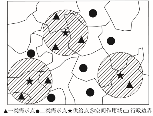
尽管高斯两步移动搜索法运算简便且增加了距离衰减函数,但其本身具有一定的缺陷,即在第一步移动搜索过程中,存在需求人口统计上的误差。在高斯两步移动搜索的过程中,首先以供给地为中心,求解其形成的空间作用域,并统计落入其空间作用域内的需求点。按照需求点的分布状况与数量进行需求人数的统计,最终求得供需比例。然而,在诸多需求点中,从空间分布角度应分为2类,本文称之为一类需求点和二类需求点。一类需求点即需求地重心落入供给地空间作用域范围内的点;而二类需求点是指有部分区域落入供给地的空间作用域内,但重心点并未落入的需求点(图1)。而现行的各种两步移动搜索法,在统计需求人数的过程中,仅计算了一类需求点,而二类需求点往往被忽略了。在需求地的空间几何图形规则的情况下,该类计算方法的精度有所保证;然而,在实际应用中,行政区划常常被当作需求地进行研究,而行政区划的形状多数往往为不规则几何体,这样提取出的需求点中就可能存在大量的二类需求点,进而使得计算结果与实际值差异较大。当然,在第二步计算研究对象的可达性时,由于也使用了类似的搜索计算方法,同样也存在该问题。
为解决上述问题,本文提出将需求地进行格网化处理。用格网的几何中心代替需求地的重心统计需求数,计算供需比,以期减轻由于形状不规则而产生的计算误差,进而提高高斯两步移动搜索法所计算研究对象空间可达性的精度,使其更加客观、真实、可靠的描述研究对象可达性的空间分布状态,为进一步的决策分析提供支持。
图1 高斯两步移动搜索法示意图
Fig.1 Gaussian based two-step floating catchment area (2SFCA) method
上海作为国家中心城市,人口众多,为合理进行城市居住区公共服务设施设置,对其进行可达性研究具有重要意义。因此,本文以上海市为研究区,包括浦东新区、长宁区、徐汇区、卢湾区、静安区、黄浦区、闸北区、虹口区、杨浦区以及普陀区。以各区的社区街道为基本单元,以第五次及第六次人口普查数据为依托,分别对上海市2000年及2010年的绿地可达性进行分析。考虑到研究区内的居民也可以使用研究区外的绿地,故研究区周边的绿地也被考虑在内。但由于研究区东北部濒临海湾,因此,并没有考虑该方向上的绿地。
数据准备:在ArcGIS中使用Fishnet命令将上海市社区数据格网化,格网单元大小为200 m×200 m;投影方式为Gauss_Kruger,共生成54210个独立的格网单元,由计算机自动生成编码。在对上海市的社区单元进行格网化的操作时,假设每个格网内的人口是均匀分布。利用Feature to point命令,将绿地与格网化的社区面状数据转换为点状数据,并求取其空间作用域范围。参考肖华斌等(2009)的研究,人的步行速度约为5 km/h,且最大承受限度不超过0.5 h,故本文选取步行0.5 h的距离约为2.5 km作为作用域半径。具体步骤为:①利用Spatial Analysis工具提取每个绿地空间作用域内的格网点,利用Field Calculate工具计算绿地点与提取后的格网点的距离,利用该距离计算高斯方程加权的绿地需求,按照绿地格网点进行加和并计算供需比。②Spatial Analysis工具提取以2.5 km为半径的每个格网点空间作用域内的绿地点,并利用Field Calculate工具计算格网点与提取后绿地点的距离,利用该距离计算高斯方程加权的格网点需求,按照格网点对供需比例进行加和得到最终的绿地可达性数值。
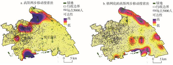
运用高斯两步移动搜索法和格网化的高斯两步移动搜索法,分别使用第五次人口普查(2000年)及第六次人口普查(2010年)数据,对研究区内绿地进行可达性评价(图2-3)。
图2 2000年上海市中心城区绿地可达性与人口分布
Fig.2 Green space accessibility and population distribution of the central urban area of Shanghai, 2000
图3 2010年上海市中心城区绿地可达性与人口分布
Fig.3 Green space accessibility and population distribution of the central urban area of Shanghai, 2010
图2a显示:2000年,研究区的绿地可达性呈现东北部及南部的可达性高、西部可达性低的整体空间特征。可达性高值区主要分布在浦东新区,形成5个大小不同的空间组团,其中东北部和南部的4个空间组团较大、东部的空间组团较小;可达性低值区主要分布在研究区的西部与浦东新区的中部。图3a显示:2010年,研究区绿地可达性呈现西高东低的整体特征。可达性高值区主要分布在西部,形成4个空间大小不同的空间组团;其中杨浦区与浦东新区交界处的组团较大,长宁区组团较小;可达性低值区主要分布在浦东新区、普陀区、黄浦区、卢湾区及徐汇区。结合研究区的绿地分布图及人口密度分布图可知(图2a和图3a),可达性高的区域周边均有较大面积的服务绿地存在,且人口密度较小;可达性低值区域存在较多的小型服务绿地,并且其人口密度相对较大。
格网化的高斯两步移动搜索法得到的可达性结果显示:2000年研究区绿地可达性呈现东高西低的整体空间特征(图2b)。高值区大多分布在浦东新区,形成6个高值区,包括东北部1个、东部2个、南部1个以及浦东新区中部2个,其中以浦东新区东北部的规模最大,南部和中部规模次之,东部规模较小;低值区主要分布在研究区的西部。2010年格网化的高斯两步移动搜索法结果(图3b)与2000年格网化的高斯两步移动搜索法结果(图2b)在整体空间特征上较为相似,高值区与低值区分布情况大体相同。整体上看,格网化的高斯两步移动搜索法以绿地为中心,呈环状向外扩散并且可达性逐渐降低。对照上海市绿地的分布图及人口密度分布图可知(图2b和图3b),可达性高值区均以绿地为中心点向外扩散,距离绿地中心近且人口密度较小的地区可达性高。可达性低值区包括除浦东新区以外的其他8个区,这8个区人口密度相对较大,但现有的绿地面积较小。绿地可达性可以理解为人均享有的绿地面积,其值的高低是由绿地面积和人口密度2个因素决定的。从图2与图3中均可以看到,研究区的东北部及南部绿地面积较大且其周围人口密度较小,因此这两处成为可达性高值区。反之,绿地面积小且周围人口密度大的地区,成为可达性低值区。理论上,没有绿地的地区周围其可达性应该为零。
格网化的高斯两步移动搜索法的结果以绿地为中心呈明显的同心圆特征。从图2中可以看到,利用2种算法得到的绿地可达性结果在浦东新区中部有较大差异。在高斯两步移动搜索法中,该处可达性值与周围地区相差不明显,而在格网化的高斯两步移动搜索法中该处可达性却明显高于周围地区。在图3中,浦东新区中部也存在同样的情况。出现这种情况的原因是,高斯两步移动搜索法得到的绿地可达性是各街道将面数据转化成点数据之后的离散数值,不能对计算结果进行空间展布,因此引入空间插值来获得空间上的可达性值。空间插值将离散的点根据某种规则将点转化为面,用已知的点推测同一区域内的未知点,这种插值的结果必然会与现实有一定的误差。从研究区整体看,因为浦东新区东北部及南部与中部的绿地面积差别不大(图2),从理论上讲,这三处的空间可达性值应具有较小的差异。但由于高斯两步移动搜索法选取街道中心点作为需求地来计算绿地可达性,且最后通过插值的方法对空间可达性值进行空间展布,进而导致了图2a中的结果。同理,图3a中也存在类似的情况,即浦东新区东部与南部均存在较为集中的小型服务绿地,但其可达性与周围地区差别不明显。可见,利用空间插值的方法对绿地的空间可达性进行空间展布确实存在一定的问题,会对结果产生较大的误差。然而格网化的高斯两步移动搜法可直接对可达性结果进行空间展布,因此改进后的结果会更符合实际情况。
虽然浦东新区东部均属可达性高值区,但可达性的值却有较大差别,图2b中该处可达性值明显要高于图2a,可达性高值分布也不尽相同。这是因为高斯两步移动搜索法以街道的中心点来计算供需比,从而得到绿地的可达性。这样就会出现以下情况:虽然以绿地为中心的空间作用域确实影响了某些街道,但该街道的中心点并未被绿地的空间作用域包括在内,导致该街道的需求者没有被计算在内,从而使得供需比不准确。在第二步计算可达性时也存在同样的问题,导致可达性的不准确,在图3a中尤为突出。A处的绿地面积为126 km2,B处的绿地面积为106 km2。而从图3a中明显可以看到,A处的人口密度远远小于B处的人口密度,A处的可达性反而低于B处。运用高斯两步移动搜索法计算第二步可达性时,使用绿地的中心点与街道中心点距离进行计算,一旦街道中心点到绿地中心点的距离大于2.5 km,该算法就会认为该处的绿地可达性为零。然而实际上,在街道点以2.5 km为半径进行搜索时,可能会有一部分的绿地落入搜索区域中,因而就会导致A、B两处可达性的差异。而改进后的方法,将街道数据划分为200 m×200 m正方形格网,利用格网的中心代替街道重心计算供需比,这样就会精确地统计出落入空间作用域内的需求者,得到更准确的供需比。同理,在第二步中,也会精确地统计出落入街道空间作用域内的绿地面积,这样就会得到更贴近实际的可达性,结果得到优化。从图2b与图3b可以看出,改进后的方法是合理、有效,也是有普适性的。它不只是针对某一年的可达性可以进行计算,对不同年份、不同人口数量均能进行可达性计算,说明改进后的方法具有普适性。
本文通过对高斯两步移动搜索法算法的详细分析,发现该方法虽然运算简便,可操作性强,但其将供给地和需求地以点状要素进行计算,忽略了其面状特征,导致统计供给地空间作用域范围内的需求者时存在较大误差。同时,由于高斯两步移动搜索法利用插值的方法将计算结果进行空间展布,这使其计算结果有较大的误差。为解决上述问题,计算出更准确的可达性,本文对高斯两步移动搜索法进行了需求地格网化处理,提出了格网化的高斯两步移动搜索法;并以上海市为研究区,其绿地可达性为研究对象,利用ArcGIS 10.0软件,以第五次和第六次人口普查数据为依托,将高斯两步移动搜索法与格网化的高斯两步移动搜索法进行对比分析。结果显示:在研究区内,2000年高斯两步移动搜索法及格网化的高斯两步移动搜索法均表现为东高西低的整体空间特征;2010年高斯两步移动搜索法整体空间特征为西高东低,2010年格网化的高斯两步移动搜索法整体空间特征为东高西低。结合研究区内绿地与人口分布情况,综合分析发现,格网化的高斯两步移动搜索法所得结果较为符合实际,且更为精确,可很好地反映上海市绿地空间配置情况,说明本文对高斯两步移动搜索法的改进合理、有效;并且格网化的方法具有普适性,亦可应用到其他的公共服务设施的空间可达性研究。
但本文也存在以下不足之处:一是由于本文将行政单元格网化,且假设每个格网内的人口是均匀分布,然而实际上,每个格网内的人口数量并不一定相同,因此格网化与实际还有一定的差异性。二是仅将改进的高斯两步移动搜索法用于对上海市的绿地进行可达性分析,而高斯两步移动搜索法最开始用于就医的空间可达性分析,改进后的高斯两步移动搜索法对其他公共服务设施空间可达性分析还有待进行深入研究。
The authors have declared that no competing interests exist.
| [1] |
基于2步移动搜索法的城市郊区公园绿地空间可达性分析 [J].https://doi.org/10.3969/j.issn.1003-6075.2011.03.009 URL 摘要
随着城市化进程的发展,大城市郊区绿地资源空间分布不均匀现象日 益突出,公园绿地空间可达性分析可以为城市郊区公园绿地空间布局规划提供科学依据。以2005年南京市郊雨花台区公园绿地为研究对象,运用2步移动搜索法 (2SFCA),计算研究区公园绿地可达性指数,并通过在研究区南部增加5个湿地公园的方式,进行规划前后公园绿地空间可达性改善状况的对比分析。研究结 果表明:①雨花台区靠近主城区和风景区的北部、东南部可达性指数较高,中部指数中等,而南部偏远农村地区可达性指数偏低;②规划后公园绿地可达性指数低、 中等部分几乎全部消失,研究区公园绿地可达性指数将提高到一个较高层次;③规划后,研究区域公园绿地不平衡分布状况得到极大改善,符合雨花台区生态环境建 设发展方向。
Spatial accessibility analysis of green space in suburb parks based on 2SFCA [J].https://doi.org/10.3969/j.issn.1003-6075.2011.03.009 URL 摘要
随着城市化进程的发展,大城市郊区绿地资源空间分布不均匀现象日 益突出,公园绿地空间可达性分析可以为城市郊区公园绿地空间布局规划提供科学依据。以2005年南京市郊雨花台区公园绿地为研究对象,运用2步移动搜索法 (2SFCA),计算研究区公园绿地可达性指数,并通过在研究区南部增加5个湿地公园的方式,进行规划前后公园绿地空间可达性改善状况的对比分析。研究结 果表明:①雨花台区靠近主城区和风景区的北部、东南部可达性指数较高,中部指数中等,而南部偏远农村地区可达性指数偏低;②规划后公园绿地可达性指数低、 中等部分几乎全部消失,研究区公园绿地可达性指数将提高到一个较高层次;③规划后,研究区域公园绿地不平衡分布状况得到极大改善,符合雨花台区生态环境建 设发展方向。
|
| [2] |
就医空间可达性分析的两步移动搜索法: 以江苏省东海县为例 [J].https://doi.org/10.11820/dlkxjz.2012.12.005 URL Magsci 摘要
精确评价医疗设施可达性的空间 分异样状况是合理配置医疗资源的前提。本文在回顾国内外关于医疗空间可达性研究的基础上,采用两步移动搜索法,以江苏省贫困县——东海县为案例,以行政村 和医院为分析单元,基于迪卡斯特拉算法计算出各村到医院(卫生院)的最短通行时间,进而分析各村医疗空间可达性分异情况。采用不用服务时间阈值范围进行空 间敏感性分析,综合研判缺医地区分布特点。与传统的医卫人员和人口比值的方法相比,两步移动搜索法能有效显示县域范围内医疗可达性的空间分异情况。采用较 大的时间阈值,医疗空间可达性分异较为平滑,采用较小服务阈值则空间分异显著,缺医范围也较大。东海县医疗空间可达性整体呈单核结构,并沿主要交通线延 伸,缺医地区多分布于边缘乡镇。提高边缘乡镇的行政村的甲级卫生院等级和乡村道路等级将会改善边缘乡镇的就医可达性。
A two-step floating catchment area (2SFCA) method for measuring spatial accessibility to primary healthcare searvice in China: A case study of Donghai County in Jiangsu Province [J].https://doi.org/10.11820/dlkxjz.2012.12.005 URL Magsci 摘要
精确评价医疗设施可达性的空间 分异样状况是合理配置医疗资源的前提。本文在回顾国内外关于医疗空间可达性研究的基础上,采用两步移动搜索法,以江苏省贫困县——东海县为案例,以行政村 和医院为分析单元,基于迪卡斯特拉算法计算出各村到医院(卫生院)的最短通行时间,进而分析各村医疗空间可达性分异情况。采用不用服务时间阈值范围进行空 间敏感性分析,综合研判缺医地区分布特点。与传统的医卫人员和人口比值的方法相比,两步移动搜索法能有效显示县域范围内医疗可达性的空间分异情况。采用较 大的时间阈值,医疗空间可达性分异较为平滑,采用较小服务阈值则空间分异显著,缺医范围也较大。东海县医疗空间可达性整体呈单核结构,并沿主要交通线延 伸,缺医地区多分布于边缘乡镇。提高边缘乡镇的行政村的甲级卫生院等级和乡村道路等级将会改善边缘乡镇的就医可达性。
|
| [3] |
公共服务设施空间可达性及其度量方法 [J].https://doi.org/10.11820/dlkxjz.2010.10.009 URL Magsci 摘要
<p>空间可达性度量既可用于评价公共服务设施空间布局的合理性,也可用于比较规划方案的优劣。公共服务设施空间可达性度量需要针对不同设施特有的空间布局目标,选取与之相适应的可达性评价因子,并采用合适的度量方法展开,对此进行专题研究的文献并不多见。本文一方面在对公共服务设施按照时效性、接受性、数量、等级性进行分类的基础上,系统阐述如何针对不同设施进行空间布局目标设定和可达性评价因子选取;另一方面将主要的度量方法分为比例法、最近距离法、基于机会累积的方法、基于空间相互作用的方法,并对各类方法的应用领域及优缺点予以分析比较,同时以潜能模型、两步移动搜寻法为例探讨相关方法在公共服务设施空间可达性度量中的应用;最后在对上述研究总结评述的基础上,本文指出多等级设施空间可达性、从需求者的活动规律考虑空间可达性、针对各类设施的综合空间可达性以及相关度量方法与GIS的集成等主题值得投入更多关注。</p>
Spatial accessibility to public service facilities and its measurement approaches [J].https://doi.org/10.11820/dlkxjz.2010.10.009 URL Magsci 摘要
<p>空间可达性度量既可用于评价公共服务设施空间布局的合理性,也可用于比较规划方案的优劣。公共服务设施空间可达性度量需要针对不同设施特有的空间布局目标,选取与之相适应的可达性评价因子,并采用合适的度量方法展开,对此进行专题研究的文献并不多见。本文一方面在对公共服务设施按照时效性、接受性、数量、等级性进行分类的基础上,系统阐述如何针对不同设施进行空间布局目标设定和可达性评价因子选取;另一方面将主要的度量方法分为比例法、最近距离法、基于机会累积的方法、基于空间相互作用的方法,并对各类方法的应用领域及优缺点予以分析比较,同时以潜能模型、两步移动搜寻法为例探讨相关方法在公共服务设施空间可达性度量中的应用;最后在对上述研究总结评述的基础上,本文指出多等级设施空间可达性、从需求者的活动规律考虑空间可达性、针对各类设施的综合空间可达性以及相关度量方法与GIS的集成等主题值得投入更多关注。</p>
|
| [4] |
两步移动搜寻法及其扩展形式研究进展 [J].https://doi.org/10.18306/dlkxjz.2016.05.006 URL 摘要
两步移动搜寻法是公共服务设施空间可达性研究中的重要方法,在国内外公共服务设施布局研究中得到了广泛应用,且发展出了众多扩展形式。但国内研究中对两步移动搜寻法尤其是其扩展形式的应用还较为有限。本文对两步移动搜寻法的主要扩展形式进行系统梳理和总结,将国内外研究中提出的两步移动搜寻法扩展形式归纳为基于引入距离衰减函数的扩展、对搜寻半径的扩展、针对需求或供给竞争的扩展以及基于出行方式的扩展4类,并分析了各种扩展形式的优缺点、适用情景以及未来可能改进方向。旨在为相关研究的方法选择提供参考,促进两步移动搜寻法及其扩展形式在国内相关领域的应用和发展。
Research progress of the two-step floating catchment area method and extensions [J].https://doi.org/10.18306/dlkxjz.2016.05.006 URL 摘要
两步移动搜寻法是公共服务设施空间可达性研究中的重要方法,在国内外公共服务设施布局研究中得到了广泛应用,且发展出了众多扩展形式。但国内研究中对两步移动搜寻法尤其是其扩展形式的应用还较为有限。本文对两步移动搜寻法的主要扩展形式进行系统梳理和总结,将国内外研究中提出的两步移动搜寻法扩展形式归纳为基于引入距离衰减函数的扩展、对搜寻半径的扩展、针对需求或供给竞争的扩展以及基于出行方式的扩展4类,并分析了各种扩展形式的优缺点、适用情景以及未来可能改进方向。旨在为相关研究的方法选择提供参考,促进两步移动搜寻法及其扩展形式在国内相关领域的应用和发展。
|
| [5] |
北京市养老设施空间可达性评价 [J].https://doi.org/10.11820/dlkxjz.2014.05.003 URL Magsci [本文引用: 1] 摘要
发展养老服务是当前中国社会建设中的重要部分。近年来,北京市养老设施发展迅速,但是由于快速的人口老龄化,北京市养老设施的供给仍难以满足老年人口对养老设施的需求。对北京市养老设施空间可达性进行科学评价是进行合理空间配置的基础,具有重要的现实意义。本文基于GIS技术,应用改进的两步移动搜索法,对北京市养老设施的空间可达性进行了测算,并重点对1小时单一有效服务半径和按养老设施规模划分的三级有效服务半径这两种情形进行了比较分析。结果表明,后者对北京市养老设施的空间可达性评价更具合理性。本文对空间可达性的测算结果识别出了北京市各区域养老设施的稀缺程度,为养老设施的空间布局提出了政策性建议。
Measuring spatial accessibility to residential care facilities in Beijing [J].https://doi.org/10.11820/dlkxjz.2014.05.003 URL Magsci [本文引用: 1] 摘要
发展养老服务是当前中国社会建设中的重要部分。近年来,北京市养老设施发展迅速,但是由于快速的人口老龄化,北京市养老设施的供给仍难以满足老年人口对养老设施的需求。对北京市养老设施空间可达性进行科学评价是进行合理空间配置的基础,具有重要的现实意义。本文基于GIS技术,应用改进的两步移动搜索法,对北京市养老设施的空间可达性进行了测算,并重点对1小时单一有效服务半径和按养老设施规模划分的三级有效服务半径这两种情形进行了比较分析。结果表明,后者对北京市养老设施的空间可达性评价更具合理性。本文对空间可达性的测算结果识别出了北京市各区域养老设施的稀缺程度,为养老设施的空间布局提出了政策性建议。
|
| [6] |
基于高斯两步移动搜索法的沈阳市绿地可达性评价 [J].https://doi.org/10.11820/dlkxjz.2014.04.005 URL Magsci 摘要
基于高斯两步移动搜索法,进行沈阳市绿地可达性分析。在揭示研究区内绿地可达性空间格局的同时,探索这一新方法的实际应用价值。结果显示:① 沈阳市绿地可达性整体上具有北高南低、东高西低的空间分布特征,4 个高值区与3 个低值区可清晰识别;高值区域主要分布在核心城区的近外围,低值区域主要分布于核心城区与城市的西部及南部远郊。② 沈阳市绿地可达性空间格局十分不平衡,具有较强的空间极化特征,70%以上的街道绿地可达性低于全市平均水平,只有少数街道呈现较高的可达性,人口与绿地的空间不匹配是造成不平衡的主要因素。③ 根据可达性评价结果,提出了实施空间优化策略,促进绿地服务均等化的相关建议。该方法能够较好地揭示城市绿地系统与人口相互作用的规律,未来还应进一步与客观实际结合,使之更加具体化和实用化。
Evaluation of green space accessibility of Shenyang using Gaussian based 2-step floating catchment area method [J].https://doi.org/10.11820/dlkxjz.2014.04.005 URL Magsci 摘要
基于高斯两步移动搜索法,进行沈阳市绿地可达性分析。在揭示研究区内绿地可达性空间格局的同时,探索这一新方法的实际应用价值。结果显示:① 沈阳市绿地可达性整体上具有北高南低、东高西低的空间分布特征,4 个高值区与3 个低值区可清晰识别;高值区域主要分布在核心城区的近外围,低值区域主要分布于核心城区与城市的西部及南部远郊。② 沈阳市绿地可达性空间格局十分不平衡,具有较强的空间极化特征,70%以上的街道绿地可达性低于全市平均水平,只有少数街道呈现较高的可达性,人口与绿地的空间不匹配是造成不平衡的主要因素。③ 根据可达性评价结果,提出了实施空间优化策略,促进绿地服务均等化的相关建议。该方法能够较好地揭示城市绿地系统与人口相互作用的规律,未来还应进一步与客观实际结合,使之更加具体化和实用化。
|
| [7] |
基于可达性和服务面积的公园绿地空间分布研究 [J].https://doi.org/10.3969/j.issn.1006-0022.2009.02.016 URL [本文引用: 1] 摘要
传统的绿地评价指标具有明显的局限性,不能反映实际的空间分布和使用情况.本文通过结合地理信息系统中的空间分析工具,提出了空间可达性和服务面积的绿地评价指标,并希望能够基于此建立更加完善的评价体系,在公园绿地的布局上兼顾到公平和效率的原则.以广州市的四个城区为例,对现有的公园绿地进行了空间分布上的评价,以期对今后的规划和建设提供依据.
Green space distribution based on accessibility and serving area [J].https://doi.org/10.3969/j.issn.1006-0022.2009.02.016 URL [本文引用: 1] 摘要
传统的绿地评价指标具有明显的局限性,不能反映实际的空间分布和使用情况.本文通过结合地理信息系统中的空间分析工具,提出了空间可达性和服务面积的绿地评价指标,并希望能够基于此建立更加完善的评价体系,在公园绿地的布局上兼顾到公平和效率的原则.以广州市的四个城区为例,对现有的公园绿地进行了空间分布上的评价,以期对今后的规划和建设提供依据.
|
| [8] |
基于E2SFCA的城市旅游景点的潜在空间可达性分析 [J].https://doi.org/10.14188/j.2095-6045.2015.01.021 URL 摘要
针对城市景点空间分布的公平性问题,以武汉市为例,使用增强的二 步移动搜索法(E2SFCA)对武汉市景点的潜在可达性进行了研究.分别选取60 min、180 min作为最大搜索范围,分别得到了E2SFCA可达性效果图.分析结果可知,武汉市景点潜在空间可达性不均衡,整体上表现出中心城区可达性较高边远辖区 可达性较低的圈层结构.最大搜索范围为180 min的可达性比60 min的可达性均衡性好,圈层结构更明显.
Potential spatial accessibility to urban scenic spots based on E2SFCA [J].https://doi.org/10.14188/j.2095-6045.2015.01.021 URL 摘要
针对城市景点空间分布的公平性问题,以武汉市为例,使用增强的二 步移动搜索法(E2SFCA)对武汉市景点的潜在可达性进行了研究.分别选取60 min、180 min作为最大搜索范围,分别得到了E2SFCA可达性效果图.分析结果可知,武汉市景点潜在空间可达性不均衡,整体上表现出中心城区可达性较高边远辖区 可达性较低的圈层结构.最大搜索范围为180 min的可达性比60 min的可达性均衡性好,圈层结构更明显.
|
| [9] |
Black residential segregation, disparities in spatial access to health care facilities, and late-stage breast cancer diagnosis in metropolitan Detroit [J].https://doi.org/10.1016/j.healthplace.2010.06.012 URL PMID: 20630792 摘要
This study evaluates the role of black residential segregation and spatial access to health care in explaining the variation in late-stage diagnosis of breast cancer in metropolitan Detroit. Data pertaining to female breast cancer from 1998 to 2002 are obtained from the Michigan Cancer Surveillance Program. An isolation index is used to assess black segregation. The 2-step floating catchment area approach integrated with a Gaussian function is used to estimate the health care access. While socioeconomic factors at ZIP code level are controlled, ordinary least squares and spatial lag models are used to explore the association between the rates of late-stage diagnosis and segregation and health care access. Results suggest that living in areas with greater black segregation and poorer mammography access significantly increases the risk of late diagnosis of breast cancer. Disadvantaged populations including those with low socioeconomic status or sociocultural barriers tend to experience high rates of late diagnosis. Findings emphasize the need for heightened screening, surveillance, and intervention programs in these areas. Copyright 2010 Elsevier Ltd. All rights reserved.
|
| [10] |
Racial/ethnic and socioeconomic disparities in urban green space accessibility: Where to intervene [J].https://doi.org/10.1016/j.landurbplan.2011.05.002 URL Magsci 摘要
Access to green spaces is important to physical activities and public health, yet one concern remains as to whether the disparities in green space access exist. This study aimed to (1) introduce an approach to quantify potential spatial accessibility to green spaces in a Geographic Information Systems (GIS) environment; and (2) evaluate the racial/ethnic and socioeconomic disparities in green space access. Urban green spaces (n
|
| [11] |
Effects of servicescape on perceived service quality, satisfaction and behavioral outcomes in public service facilities [J].https://doi.org/10.3130/jaabe.13.125 URL Magsci 摘要
The identification of significant factors affecting the behaviors of customers and occupants of physical environments and assessing their importance are imperative for effective architectural planning and design. This study investigated the effects of servicescape on perceived service quality and behavioral intention. The four main factors of servicescape selected for this study were attractiveness, cleanliness, layout, and comfort; the two perception indicators were service quality and satisfaction; and the behavioral outcome measures were loyalty and public service facility revisit intentions. A total of 594 questionnaires were collected from the users of five public service facilities located in Seoul, Korea. SPSS 18 and Lisrel 8.54, confirmatory factor analysis, and structural equation modeling (SEM) were used to test hypotheses. The results revealed that cleanliness had a significantly direct impact on users鈥 satisfaction and an indirect impact on loyalty and reuse in public service facilities. Easy layout (easy access) was also found to be an essential factor for service quality and satisfaction. The findings also support the positive effects of comfort on perceived service quality and satisfaction. Although attractiveness was expected to be an indicator, the results failed to support a relationship between attractiveness and service quality or satisfaction.
|
| [12] |
Suitability evaluation of rural settlements based on accessibility of production and living: A case study of Tingzu Town in Hubei Province of China [J].https://doi.org/10.1007/s11769-015-0771-0 URL 摘要
Rural settlements are the main carriers of agriculture, rural areas and farmers; thus, optimizing the production and living space of rural settlements is highly significant to rural development. Taking the effective allocation of resources as the starting point, a suitability evaluation system of rural settlements, based on accessibility of production and living, was proposed in this study to provide scientific basis for the optimization of production and living space. The accessibility of production and living was measured by an improved two-step floating catchment area method, which considered proximity and availability based on the inclination of rural residents. The suitability evaluation system consisted of traditional suitability evaluation and newly proposed limiting factor identification based on the loss score proportion of suitability. Tingzu Town of Hubei Province, China, was chosen as the case study area. Based on the results of the suitability evaluation system, corresponding suggestions on rural land consolidation, industry division, as well as the layout of health care and education facilities were proposed to optimize the production and living space of rural settlements in Tingzu Town. It is found that the suitability evaluation based on accessibility of production and living is more scientific and accurate than the traditional ones which significantly overestimate production and living convenience. Moreover, the limiting factor identification can help us put forward suggestions according to local conditions and bring about the highly targeted optimization of production and living space of rural settlements.
|
| [13] |
An enhanced two-step floating catchment area (E2SFCA) method for measuring spatial accessibility to primary care physicians [J].https://doi.org/10.1016/j.healthplace.2009.06.002 URL PMID: 19576837 摘要
This paper presents an enhancement of the two-step floating catchment area (2SFCA) method for measuring spatial accessibility, addressing the problem of uniform access within the catchment by applying weights to different travel time zones to account for distance decay. The enhancement is proved to be another special case of the gravity model. When applying this enhanced 2SFCA (E2SFCA) to measure the spatial access to primary care physicians in a study area in northern Illinois, we find that it reveals spatial accessibility pattern that is more consistent with intuition and delineates more spatially explicit health professional shortage areas. It is easy to implement in GIS and straightforward to interpret.
|
| [14] |
Measures of spatial accessibility to health care in a GIS environment: Synthesis and a case study in the Chicago region [J]. |
| [15] |
Variable catchment sizes for the two-step floating catchment area (2SFCA) method [J].https://doi.org/10.1016/j.healthplace.2012.04.002 URL PMID: 22560115 摘要
Government efforts designed to help improve healthcare access rely on accurate measures of accessibility so that resources can be allocated to truly needy areas. In order to capture the interaction between physicians and populations, various access measures have been utilized, including the popular two-step floating catchment area (2SFCA) method. However, despite the many advantages of 2SFCA, the problems associated with using fixed catchment sizes have not been satisfactorily addressed. We propose a new method to dynamically determine physician and population catchment sizes by incrementally increasing the catchment until a base population and a physician-to-population ratio are met. Preliminary application to the ten-county region in northern Illinois has demonstrated that the new method is effective in determining the appropriate catchment sizes across the urban to suburban/rural continuum and has revealed greater detail in spatial variation of accessibility compared to results using fixed catchment sizes.
|
| [16] |
a. A new index of access to primary care services in rural areas [J].https://doi.org/10.1111/j.1753-6405.2009.00422.x URL PMID: 19811476 [本文引用: 1] 摘要
Abstract Objective: To outline a new index of access to primary care services in rural areas that has been specifically designed to overcome weaknesses of using existing geographical classifications. Methods: Access was measured by four key dimensions of availability, proximity, health needs and mobility. Population data were obtained through the national census and primary care service data were obtained through the Medical Directory of Australia. All data were calculated at the smallest feasible geographical unit (collection districts). The index of access was measured using a modified two-step floating catchment area (2SFCA) method, which incorporates two necessary additional spatial functions (distance-decay and capping) and two additional non-spatial dimensions (health needs and mobility). Results: An improved index of access, specifically designed to better capture access to primary care in rural areas, is achieved. These improvements come from: 1) incorporation of actual health service data in the index; 2) methodological improvements to existing access measures, which enable both proximity to be differentiated within catchments and the use of varying catchment sizes; and 3) improved sensitivity to small-area variations. Conclusion: Despite their recognised weaknesses, the Australian government uses broad geographical classifications as proxy measures of access to underpin significant rural health funding programs. This new index of access could provide a more equitable means for resource allocation. Implications: Significant government funding, aimed at improving health service access inequities in rural areas, could be better targeted by underpinning programs with our improved access measure.
|
| [17] |
b. The index of rural access: An innovative integrated approach for measuring primary care access [J].https://doi.org/10.1186/1472-6963-9-124 URL PMID: 19624859 [本文引用: 1] 摘要
Abstract BACKGROUND: The problem of access to health care is of growing concern for rural and remote populations. Many Australian rural health funding programs currently use simplistic rurality or remoteness classifications as proxy measures of access. This paper outlines the development of an alternative method for the measurement of access to primary care, based on combining the three key access elements of spatial accessibility (availability and proximity), population health needs and mobility. METHODS: The recently developed two-step floating catchment area (2SFCA) method provides a basis for measuring primary care access in rural populations. In this paper, a number of improvements are added to the 2SFCA method in order to overcome limitations associated with its current restriction to a single catchment size and the omission of any distance decay function. Additionally, small-area measures for the two additional elements, health needs and mobility are developed. By utilising this improved 2SFCA method, the three access elements are integrated into a single measure of access. This index has been developed within the state of Victoria, Australia. RESULTS: The resultant index, the Index of Rural Access, provides a more sensitive and appropriate measure of access compared to existing classifications which currently underpin policy measures designed to overcome problems of limited access to health services. The most powerful aspect of this new index is its ability to identify access differences within rural populations at a much finer geographical scale. This index highlights that many rural areas of Victoria have been incorrectly classified by existing measures as homogenous in regards to their access. CONCLUSION: The Index of Rural Access provides the first truly integrated index of access to primary care. This new index can be used to better target the distribution of limited government health care funding allocated to address problems of poor access to primary health care services in rural areas.
|
| [18] |
Measuring potential spatial access to primary health care physicians using a modified gravity model [J].https://doi.org/10.1111/j.1541-0064.2009.00301.x URL [本文引用: 1] 摘要
Ensuring equity of access to primary health care (PHC) across Canada is a continuing challenge, especially in rural and remote regions. Despite considerable attention recently by the World Health Organization, Health Canada and other health policy bodies, there has been no nation-wide study of potential (versus realized) spatial access to PHC. This knowledge gap is partly attributable to the difficulty of conducting the analysis required to accurately measure and represent spatial access to PHC. The traditional epidemiological method uses a simple ratio of PHC physicians to the denominator population to measure geographical access. We argue, however, that this measure fails to capture relative access. For instance, a person who lives 90 minutes from the nearest PHC physician is unlikely to be as well cared for as the individual who lives more proximate and potentially has a range of choice with respect to PHC providers. In this article, we discuss spatial analytical techniques to measure potential spatial access. We consider the relative merits of kernel density estimation and a gravity model. Ultimately, a modified version of the gravity model is developed for this article and used to calculate potential spatial access to PHC physicians in the Canadian province of Nova Scotia. This model incorporates a distance decay function that better represents relative spatial access to PHC. The results of the modified gravity model demonstrate greater nuance with respect to potential access scores. While variability in access to PHC physicians across the test province of Nova Scotia is evident, the gravity model better accounts for real access by assuming that people can travel across artificial census boundaries. We argue that this is an important innovation in measuring potential spatial access to PHC physicians in Canada. It contributes more broadly to assessing the success of policy mandates to enhance the equitability of PHC provisioning in Canadian provinces.
|
| [19] |
An accessibility-based integrated measure of relative spatial equity in urban public facilities [J].https://doi.org/10.1016/j.cities.2005.07.004 URL Magsci [本文引用: 1] 摘要
<p id="">The achievement of equity in the distribution of urban public facilities is a goal of paramount importance to urban planners, who must analyze whether and to what degree their distribution is equitable. Recent efforts have probed into the equity of one type of facility, leaving an overall examination unconsidered. In this paper, integrated equity indices with which planners can analyze the relative equity status of facility distributions are presented, integrating GIS and spatial analysis models. Ren-de, Taiwan is the test site for this prototype method, and results show it allows users to understand the characteristics of spatial equity both for disaggregated and aggregated levels, and it demonstrates significant differences between urban public facilities.</p>
|
| [20] |
A relative spatial access assessment approach for analyzing potential spatial access to colorectal cancer services in Texas [J].https://doi.org/10.1016/j.apgeog.2011.05.001 URL Magsci 摘要
The usefulness of gravity-based spatial access models is limited because of the uncertainty introduced by the range of values of the impedance coefficient. To solve this problem, this paper proposes the concept of spatial access ratio (SPAR) derived from the enhanced 2-step floating catchment area (E2SFCA) method鈥 a recent extension of the gravity model 鈥 to assess potential spatial access. First, a sensitivity assessment is conducted to verify the effectiveness of SPAR and its advantages in overcoming the uncertainty problem. Then, the E2SFCA method and the shortest travel time method are employed to measure potential spatial access to colorectal cancer (CRC) prevention and treatment services in Texas based on data at the census tract level. The socio-demographic and geographic distributions of potential spatial access to CRC services are also examined. The sensitivity assessment reveals substantial fluctuations in the values of the spatial access index calculated directly by the E2SFCA method under different values of the impedance coefficient. However, the values of SPAR remain stable under different values of the coefficient. A comparative analysis indicates that potential spatial access to primary care physicians (PCPs), CRC screening facilities, and oncologists varied among different racial/ethnic and socioeconomic population groups as well as in different geographic regions in Texas. Non-Hispanic blacks, Asians, and people in affluent areas had a geographical advantage in accessing CRC services than other groups. The urban/rural difference was more obvious and serious than those of different racial/ethnic groups and groups with different socio-economic statuses, as metropolitan residents had more than three times the potential spatial access than isolated rural residents.
|
| [21] |
A three-step floating catchment area method for analyzing spatial access to health services [J].https://doi.org/10.1080/13658816.2011.624987 URL [本文引用: 1] 摘要
Gravity-based spatial access models have been widely used to estimate spatial access to healthcare services in an attempt to capture the interaction of various factors. However, these models are inadequate in informing health resource allocation work due to their inappropriate assumption of healthcare demand. For the purpose of effective healthcare resource planning, this article proposes a three-step floating catchment area (3SFCA) method to minimize the healthcare-demand overestimation problem. Specifically, a spatial impedance-based competition scheme is incorporated into the enhanced two-step floating catchment area (E2SFCA) method to account for a reasonable model of healthcare supply and demand. A case study of spatial access to primary care physicians along the Austin鈥揝an Antonio corridor area in central Texas showed that the proposed method effectively minimizes the overestimation of healthcare demand and reflects a more balanced geographic pattern of spatial access than E2SFCA. In addition, by us...
|

/
| 〈 |
|
〉 |
